Grant Kohrs Ranch Fence Report
|
|
|
- Roxanne Moody
- 6 years ago
- Views:
Transcription

1 Grant Kohrs Ranch Fence Report Philip B. Davis Dr. Lisa Rew Montana State University Department of Land Resources and Environmental Sciences March 2011
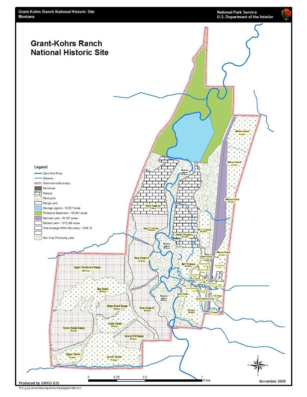
2 Table of Contents Executive Summary... iii Introduction... 1 Pasture/Hayfield Component Landscape... 5 Overview... 5 Stuart Field... 5 Stuart Annex... 7 Bull Pasture Effluent Field 5 (AKA L-Barn Field) L-Barn Field North North Meadows Effluent Fields 1-4 (AKA Front Fields) West Hay Fields Field Field Field Field Upland Pasture Component Landscape Overview Upper and Lower Taylor Fields Taylor Ridge Range Big Gulch Upper Northwest Range Little Gulch Gravel Pit Range i
3 Riparian Woodlands Landscape Overview North Riparian Cottonwood Riparian South Riparian Cottonwood Creek Riparian Development Zone Component Landscape Other Areas of Concern Johnson Creek Stock Shelters Horse Pasture Conclusions and Additional Recommendations Sources Consulted Appendix: Wildlife Compatible Fences References Acknowledgements ii
4 Executive Summary The fences at Grant-Kohrs Ranch National Historic Site (GRKO) were assessed in summer 2010 to determine which have been installed by the National Park Service (NPS) and which were present prior to NPS acquisition of the park. All fences in the Pasture/Hayfields, Upland Pasture, Riparian Woodlands, and Development Zone Component Landscapes were assessed. About half of these fences have been installed by the NPS, and most of these still serve their intended purposes. However, some should be considered for removal in the near future including the cross fences of Westside Hayfields 1-4 and Effluent Fields 1-4. Discussion of the implications of these removals and suggestions for additional fence modifications/removals are included. An additional objective of this research was to visually assess the impacts of grazing on the ranch, relative to fence locations. The area in which the most prominent damage was noticed includes a section of Johnson Creek located east of the Kohrs-Manning Ditch flume and south of stock shelters HS-24, HS-27, HS-29. It is recommended that this area be rehabilitated to improve ecological integrity and usefulness. Suggestions for improvements at Johnson Creek and additional areas within fields that exhibited minor undesirable vegetation, soil, and/or water characteristics are discussed within the specific field subsections. Lastly, research on wildlife-friendly fencing techniques that GRKO can implement to facilitate co-existence with animals that frequent the ranch are included in an appendix. Suggestions on installing drop sections, alternatives to using five- and six-strand barbed wire, and ways to enhance visibility are presented to help minimize harm to deer, elk, and birds. These options should be implemented with careful consideration to GRKO s primary goal of conveying historical accuracy. iii
5 Introduction Fences represent an important component of the historically and culturally significant Grant Kohrs Ranch National Historic Site (GRKO). They have an impact on ranch management, visitor experiences, and the ability to interpret its history. Fences also aid in conveying the spatial arrangement and historical uses of the fields within the cultural landscape, an objective that is central to the park s overall mission (18). However, since the acquisition of GRKO by the National Park Service (NPS) in 1972, many changes to the fences have occurred - over half of the existing fences were installed by the NPS in new locations. Although most of the individual replacements, additions, and removals of fences are inconsequential when considered singularly, the cumulative effects of these actions can negatively impact the ability of the ranch to convey the expansive, wide open feel that is characteristic of the historic GRKO. The primary goal of this research project was to determine if existing fence locations and material types date to the historic period of the ranch (1860s /87), or if they were installed by the NPS and why. In addition, this project determined how the presence/absence of fences impacts ecological and cultural characteristics, and the report offers recommendations to alter fences to improve historical accuracy and ecological integrity of certain areas. After surveying the ranch to determine types and locations of fences as they existed in summer 2010, various sources of information including aerial and ground-based photographs, written documents, Section 106 Compliance Reports, and maps, were consulted to determine which fences were built by the NPS and which existed prior to NPS acquisition of the park. This information was used to update the GRKO GIS fence locations database and to create a map differentiating between NPS and non-nps installed fences. Of the fences assessed during this project, more than half were installed by the NPS and are therefore, non-historic. Recommendations on removing non-essential NPS-installed fences 1
6 to facilitate historical accuracy, while maintaining a functional ranch, are provided. The primary source on which these recommendations are based is from interviews with GRKO interpretive, maintenance, and resources staff. Staff members provided insightful, but often opposing opinions, as to which fences should be removed or retained. If there was no strong consensus or disagreement among interviewed staff, and if the authors of the report did not determine any strong ecological reasons for fences built after 1972 to be removed, then no recommendations are provided in that specific section of the report. It appears that most of the newer fences (post 1972) do indeed aid ranch management, and although they potentially impair the visual openness of the landscape, it should be noted that many of the fences cannot be seen from the areas which visitors frequent. The second goal of this project was to identify areas within fields that display undesirable ecosystem attributes (soil erosion, compaction, loss of vegetation, etc.); recommendations, including non-fencing techniques, to mitigate damages in these areas are also provided. Where fencing is not currently recommended, it may be a viable approach should the extent of the damage increase over time. In addition to descriptions of these areas in this report, they are located on the fence map that was created from this project. The main text of this report addresses the project s primary goal, as described above. It is organized by Component Landscapes, as defined in the 2004 Cultural Landscape Report Part I, with each one presented in its own section. Following a brief overview of the characteristics and uses of the Component Landscape, the section is subdivided by fields, and the research results and recommendations are discussed in detail. The exception to this is the Development Zone Component Landscape, which is rather small and therefore, is not subdivided into sections based on the fields contained within it. For clarity, a satellite photograph of the field and fences being 2
7 discussed are often provided to supplement the written descriptions. There are two additional areas that were identified during the course of this project which exhibit undesirable impacts due to overuse that do not belong to any of the Component Landscapes researched in this report. These are described near the end in a separate section titled Other Areas of Concern. In addition to the main report, information about wildlife compatible fence techniques that GRKO could implement in future fence installations is also included. However, because this is not directly related to the primary goal of the project, it is presented in a separate appendix at the end of the main text. 3
8 4
9 Pasture/Hayfield Component Landscape Overview Most of the fields within the Pasture/Hayfield Component Landscape are situated in the low-lying areas on either side of the Clark Fork River, except for Effluent Fields 1-4, which are located north of the Warren Hereford Ranch. Fields within this component landscape are used for grazing and hay production, and are separated from one another with various fence types. Although most fence locations and material types are historic, many have been installed by the NPS. Of the 55 fence segments assessed in this landscape, 29 (53%) are non-historic, and 24 (44%) are historic, and two sections (0.4%) have both historic and non-historic elements. Stuart Field The east boundary fence of Stuart Field is jackleg, in its original location and in-kind material type. The south half of this fence was installed first and existed as of 1947 (1a), while the north half was present by The south boundary fence, which is also the north boundary fence of the Cottonwood Creek Riparian area, is also jackleg. The exact date of construction for this fence is not known, but it was between 1983 and 1988 (10,11,1g). Its primary function appears to be as a protective barrier to prevent damage to the Cottonwood Creek Riparian Area, and therefore, is not recommended for removal. The north boundary of Stuart Field is marked by the Clark Fork River Bridge Road that runs east-west, and immediately to the north of this road is a vertical board fence with sections of jackleg on either side. This north boundary as it exists currently is representative of the historic era (1j,2,4,11). The west boundary fence of Stuart Field, which follows the east side of the Kohrs- Manning Ditch, is also jackleg and was installed in 1995 (7) or 1996 (11) to create a new pasture for livestock management. It was not intended to be a permanent installation and because of this, it was decided that the impact of this fence would have no effect on the cultural and historical landscape of the ranch (7). In addition to the west fence, there is a short section of jackleg 5

10 extending from it to a wood gate that crosses the Clark Fork River Bridge Road, and another section of jackleg that connects the gate to the north boundary fence (Photo 1). Although the exact date of this installation is unknown, it was after the construction of the west fence in Its intended purpose was the same as the west fence, to facilitate efficient livestock management (12). The presence of the west boundary fence likely eliminates any adverse impacts to the Kohrs-Manning ditch because it restricts access by cattle from Stuart Field. Because of this, and the fact that these fences and the gate facilitate cattle management (e.g., pasture rotation and enhancing visitor contact with the animals) (19), as per their original intention, these sections are not recommended for removal. However, if GRKO is true to its mission of preserving the historical integrity of the ranch, these sections should be removed because they were installed by the NPS (19). If this is done, alternatives should be developed (e.g. hiring more staff) to ensure that management goals can still be achieved without the fence (9). Jackleg fence / gate extension West boundary fence Photo 1. Northwest corner of Stuart Field with jackleg fence and gate extension from the west boundary fence. 6
11 Stuart Annex Jackleg fences characterize all boundaries of Stuart Annex. The fence on the west boundary of Stuart Annex, which also marks the east boundary of the South Riparian portion of the Riparian Woodland Component Landscape, was originally installed by the NPS between 1983 and 1988 (1f,1g). However, it was moved further west towards the Clark Fork River in the summer of 2001 to provide horses with shelter in the winter and shade in the summer (7). The south boundary of Stuart Annex is essentially a continuation of this west boundary fence; thus, it is assumed that it was constructed and subsequently rerouted at the same time as the west fence. None of the fences in this field are historic; however, they serve as important barriers to exclude livestock from the adjacent Cottonwood and South Riparian areas. To avoid ecosystem degradation due to overgrazing, and to ensure that livestock and people are not harmed by the concentrations of heavy metals in the area (11), these fences are not recommended for removal (see Riparian Woodland Component Landscape section for alternatives to complete removal). The fence on the east boundary of Stuart Annex, just beyond the Kohrs-Manning Ditch serves as the barrier to Stuart Field. Because the majority of the length of the ditch in Stuart Annex appears to be in good condition, and it provides cattle access to water, a fence is not recommended currently. However, there are two locations that were identified as areas of concern and should be monitored to ensure that further damage is not incurred. The first section is on the north end of the ditch, where it appears that excessive widening of the channel is occurring due to pugging and hummocking. Pugging and hummocking result from grazing on moist soils, and cause soil compaction and uplift, respectively (Photo 2). These are undesirable characteristics because they can reduce land quality and usefulness. The second damaged area is near the middle of the field where cattle cross the ditch, thus exposing the soil (Photo 3). The 7


12 map that is associated with this report, located in GRKO GIS database, can be consulted for exact locations and aerial extent of the damage. Photo 2. Pugging and hummocking along the Kohrs-Manning Ditch in the Stuart Annex Field at the Clark Fork River Bridge Road. Photo 3. Exposed soil where cattle cross the Kohrs-Manning Ditch in Stuart Annex Field. If damage along the streambank increases to an unacceptable level, and because Stuart Annex is subjected to greater grazing pressure than Stuart Field, a more appropriate location for the fence might be on the west side of the Kohrs-Manning Ditch. With the inclusion of water gaps in the new fence, overall impact to the streambank might be reduced. That said, this is an irrigation ditch and therefore, its purpose is not to represent a natural system but rather, to serve as a tool for water movement on the ranch. Thus, damages to this channel can be repaired with a backhoe. 8
.")
13 There is an additional, unnamed area in the north of the Stuart Annex field that contains historic-era farming equipment and is fenced with jackleg. It is located between the current north fence of Stuart Annex and the fence along the Clark Fork River Bridge Road (Photo 4). This north fence of this section, along the Clark Fork River Bridge Road, was part of the jackleg installation on the east side of the Kohrs-Manning Ditch in Stuart Field in 1995 (7) or 1996 (11) The rest of this area was fenced between 1994 and 2001 (1j, 1l). Historically, a portion of this area was used to stack hay, and when doing so, was enclosed with a temporary fence. This area is still used for that purpose, although the fenced area is larger than in the past. N Stuart Annex Photo 4. Non-historic fenced area between the north side of Stuart Annex and the Clark Fork River Bridge Road. Through conversations with GRKO staff, there are conflicting thoughts about this area. One staff member indicated the desire to remove the portion of the jackleg fence along the Clark Fork River Bridge Road because it impedes visitors ability to view the historic farming 9
14 equipment (8). Conversely, this section facilitates effective cattle management (19), similar to fences in Stuart Field. The jackleg fence used is consistent in type with the majority of fences used in this area historically. Consequently, it does not impede greatly on the ability to interpret the history of the ranch as GRKO intends. However, if the difficult viewing of the machinery is of major concern to the park, there are two potential compromise solutions between the two opposing viewpoints presented above. First, GRKO could relocate the farming equipment to an area that is more readily apparent, and keep the fence. Second, GRKO could remove the portion of the fence along the road, thus enhancing viewing of the equipment, and simply erect a temporary fence when it is needed to protect hay. The removal of this fence would not greatly affect cattle management because the gate on the south boundary (north boundary of Stuart Annex) of this area would serve as the barrier to prevent cattle from leaving or entering Stuart Annex. Bull Pasture This field is fenced entirely with jackleg. The north boundary fence that separates the Bull Pasture from the North Meadows was created between 1979 and 1983 (1e,1f) by the NPS, and no fence existed prior. The east jackleg fence that separates the Bull Pasture from L-Barn Field South appears to represent the historic era, with the exception of the portion that was extended northward in 1975, when the NPS created the Boneyard (see section Effluent Field 5 for details about the Boneyard) (Photo 5). The southeast fence that parallels the west side of the Kohrs- Manning Ditch is not historic, as it was built between 1983 and 1988 (1f,1g,11). The south boundary of the Bull Pasture is currently jackleg. This was installed in 1995 and replaced a historic fence constructed of a patchwork of various materials that posed a safety risk to people and livestock (7). The new fence was placed in the same location as the historic fence and jackleg 10

15 was chosen because of the wet conditions in the area. The west boundary fence was installed between 1984 and 1988 (1f,1g) to exclude cattle from the Clark Fork River riparian area. Because of the valid justifications of adding and altering non-historic fences to this field, and because of the importance of The Boneyard in daily operations of GRKO, no changes to fences in this field are recommended. N The Boneyard Bull Pasture L-Barn Field South Photo 5. Historic (yellow line) and current (white line) boundaries of the Bull Pasture and north historic boundary (yellow line) of L-Barn Field South. Effluent Field 5 (AKA L-Barn Field) The south boundary of Effluent Field 5 is a jackleg fence. Although built with traditional materials (4), it is not historic in its placement. Prior to the construction of The Boneyard by the NPS in 1975 (10), the fence came directly off the north side of the L-Barn, traveling west, and terminating in the northwest corner of L-Barn Field South (1b,1d,2,4). With the creation of The 11

16 Boneyard, the south boundary fence of Effluent Field 5 was moved north from the L-Barn, to where it lies currently (Photo 6). Although the creation of The Boneyard is within the period of significance, it is a NPS installation and therefore is not historical. Effluent Field 5 N The Boneyard L-Barn Field South Photo 6. Historical and current southern boundaries (yellow and white lines, respectively) of Effluent Field 5. The north and east boundary fences of Effluent Field 5 are currently constructed of metal posts and barbed wire. The original fences were present by 1947 (1a) however, the original material used for this fence is unknown. The current fence is most likely a NPS replacement, as the fence is in very good condition. It may have been part of the fencing that Montana 12
17 Conservation Corps (MCC) did in summer 1995 because it is identical to the fences that MCC installed on the east and west boundaries of the nearby L-Barn Field North (14). However, there is no documentation to support this unequivocally. It is probable that the original material for this fence was indeed barbed wire with metal or wood posts, because barbed wire was used extensively in fields away from the Home Ranch area, and the use of metal posts date to about 1940 (11). Also, the railroad corridor, which is immediately to the east, was fenced prior to 1983 (11) ; therefore, the fences on the north and east boundary will be considered historic. The fence along the west boundary of Effluent Field 5 is constructed primarily from metal posts and barbed wire and was installed between 1994 and 2001 (1j,1l). The exception to the metal post and barbed wire fence on this boundary occurs in the northwest corner of the field. There is a short remnant section of metal post and barbed wire fence that has been abandoned in favor of a length of jackleg fence (Photo 7). This section travels west to cross the Kohrs- Manning Ditch and then northeast to meet the gate on the Warren Pumphouse Road. It was installed in 1995 at the time the west boundary fence of L-Barn Field North was constructed (7). 13
 and jackleg fence (white lines) in the northwest corner of Effluent Field 5.")
18 N Metal Post / Barbed Wire Remnant Effluent Field 5 Photo 7. Metal post and barbed wire remnant and existing fences (yellow line) and jackleg fence (white lines) in the northwest corner of Effluent Field 5. L-Barn Field North The north boundary of L-Barn Field North is characterized by a wood post and barbed wire fence and was present by 1947 (1a). Although the fence that is present now is most likely not the original fence, there is no documentation of any substantial replacements or alterations to the fenceline as it lies today. The west fenceline is constructed from metal posts and barbed wire, and parallels the Kohrs-Manning Ditch. It was installed by the NPS in 1995 (10,7,5). There is essentially no south boundary to this field, as the east and west fences converge at a gate on Warren Pumphouse Road. The east boundary fence of the L-Barn Field North adjacent to the Barrow Pit was present by 1947 (1a). In summer 1995, MCC installed a replacement that was constructed from 14
.")
19 metal posts and barbed wire. The original material used for this fence, as well as the portion surrounding The Dump, is a mixture of different types, as can be seen from the before and after photos from this installation (14). Specifically, the old fence around The Dump appears to be jackleg braces with woven wire or a combination of woven wire and barbed wire (Photo 8). Beyond the dump to the north, the pre-existing fence was made of cedar posts, with metal posts as needed (probably for repairs through time), and a mixture of woven wire, smooth wire, and barbed wire (Photo 9). Thus, the present location of the fence is historic, but the type of material chosen for the replacement is ambiguous as to its historical significance. Photo 8. Fence around The Dump before replacement by Montana Conservation Corp in summer
.")
20 Photo 9. Old fence north of The Dump before replacement by Montana Conservation Corps in summer North Meadows The north boundary fence of North Meadows is constructed from metal posts and barbed wire and was present by 1947 (1a). The west fence is also made of metal posts and barbed wire was installed in 1994 (11). The south boundary of the North Meadows is characterized with jackleg fence, which exists because of the extension of the jackleg fence from the northwest corner of L-Barn Field South, westward across the Clark Fork River (see section Lower Yard Fields for details). The east side of the North Meadows has no fence, as the Kohrs-Manning Ditch serves as the barrier to L-Barn Field North and Effluent Field 5. Effluent Fields 1-4 (AKA Front Fields) The north, east, and west outer-boundary fences surrounding Effluent Fields 1-4 consist of metal posts and barbed wire. The east and west fences were installed by 1947 (1a) and the north fence was present by 1965 (1b). The south boundary of Effluent Fields 1-4 borders the 16

21 Warren Hereford Ranch Component Landscape, and consists of several fences/materials on each side of the entrance gate. To the west of the gate, the fence posts alternate wood and metal, with a combination of woven wire and barbed wire. To the east of the entrance gate, the fence is vertical board, followed by the back wall of cow shed HS-73, and then a section of post and rail that meets with the metal post and barbed wire fence of the entire east boundary of Effluent Fields 1-4 (Photo 10). This group of fences can be considered historical, in terms of placement (11), but the exact type of fencing materials used historically has not been determined. Photo 10. South boundary fence types of Effluent Field 1, east of the entrance gate. There are three cross fences that separate the four Effluent Fields, all of which run eastwest and are constructed from metal posts and barbed wire. The fence between fields 1 and 2 was installed by Con Warren, prior to 1965 (1b). The other two were constructed in 1997, at the time when GRKO decided to utilize the City of Deer Lodge s effluent water for irrigation of Effluent Fields 1-4, as well as Effluent Field 5 (7). The purpose of the additional cross fences was to employ approximately a five-day rotation schedule with each field (including Effluent Field 5, presumably) in one of four phases: irrigation, drying, grazing, or resting. In compliance forms 17
22 from 1997 it was acknowledged that these fences would have an impact on the visual landscape. However, it was determined that this negative aspect outweighed the possibility of revitalizing the Effluent Fields, while providing a service to the City of Deer Lodge out of concern for the environment (7). Because these cross fences aid in cattle management and most visitors do not tour this area, it is not necessary to remove the fences. However, if in the future the area is frequented by visitors, then park management may want to consider the fences impact on the cultural landscape. West Hay Fields Each of the four West Hay Fields are bounded on the west by the Kohrs Ditch, the Kohrs Ditch Road, and wood post and barbed wire fence sections which was installed in 1940 (10,11). There are three cross fences running east-west that separate West Hay Fields 1-4; they are constructed from metal posts and barbed wire. The first of these cross fences was installed in 1995 (15,16), thereby separating Field 4 from the rest of the West Hayfield. The purpose of this fence was to supply additional pasture in the summer and the West Hayfield 4 was chosen because it was difficult to provide adequate irrigation to that area for hay production, the traditional use (7). In the NPS compliance report for this project it was decided that the addition of this non-historic fence would be unobtrusive to the visual landscape. The remaining two cross fences were constructed in 1997, thereby creating West Hayfields 1, 2, and 3 (11,16). The following details focus on fences that are unique to each West Hayfield that were not previously described: 18
23 Field 1 The east boundary fence, north of the South Pumphouse is jackleg and was originally installed by the NPS between 1979 and 1983 (1e,1f). In summer 2001, this fence was moved east toward the Clark Fork River to provide shelter for stock (7). In the compliance report for this project, it was noted that this alteration was acceptable because it more closely mimicked the placement of the original fence installed in that area by Con Warren. However, through this research, no fence was identified to have existed prior to the NPS installation between 1979 and South of the South Pumphouse, the fence is metal post and barbed wire and was erected by the NPS between 1972 and 1979 (1c,1e). The south boundary fence of Western Hay Field 1 is wood posts and barbed wire and was installed ca. 1930s (11). Field 2 The east boundary fence is primarily jackleg, with the exception of a small stretch of metal post and barbed wire on the north end of the east fence. The jackleg section was built between 1979 and 1983 (1e,1f) and the barbed wire section was built in 1994 (11). Field 3 The east boundary fence is metal post and barbed wire and was installed in 1994 (11). The cross fence separating Field 3 from Field 4 is nearly all metal post and barbed wire, as mentioned above; however, there is a short section of jackleg on the west side of the entrance gate to Field 4 (Photo 11). It is not known if this portion was built in 1995 at the time the rest of the cross fence was installed. 19
. The east boundary fence is also metal post and barbed wire and was installed in 1994 (11).")
24 GRKO Boundary Jackleg West Hayfield 4 Metal Post / Barbed Wire N Metal Gate West Hayfield 3 Photo 11. Cross fence between Western Hayfields 3 and 4. Field 4 The north boundary fence is made from metal posts and barbed wire and was present by 1965 (1b). The east boundary fence is also metal post and barbed wire and was installed in 1994 (11). The cross fences themselves are not a visual distraction from a distance, but the way they are utilized and managed (e.g. hay, pasture), if different on adjacent fields, can create a discontinuous or chopped up feel of what used to be one large expanse. This is especially apparent towards the end of the summer and into the fall when haying occurs. GRKO staff has indicated the desire to reduce the number of these fences or eliminate them altogether. If all fences were eliminated it would increase the need to move cows and possibly install temporary electric fences so that areas that they prefer do not receive too much pressure. It is recommended that the fences be removed in stages, so management plans can be developed to avoid overgrazing. The cross fence between Fields 2 and 3 causes the most visual intrusion from a distance; therefore, this fence is recommended to be removed first. The fence between Fields 1 20
25 and 2 that parallels the Clark Fork River Bridge Road is not as much of a concern because the road splits those two fields anyway. The fence that separates Field 3 from Field 4 should be the last priority because of its distance from the main visitor areas. Also, inadequate irrigation to this field reduces its productivity for hay as compared to the other fields, but provides a useable pasture for cows (19). 21
26 Upland Pasture Component Landscape Overview The Upland Pasture Component Landscape became part of the historic Grant, Kohrs, and Warren Ranch in the 1930s and the property boundary was fenced about the same time. Traditional uses of this area include grazing and hay production, and irrigation is provided via lateral ditches sourced from Taylor Creek on the park s southern boundary and the West Side Ditch from the Clark Fork River. Of the 24 fence segments assessed in the Upland Pasture, 12 (50%) are non-historic and 12 (50%) are historic. All of the interior fences in the Upland Pasture were installed by the NPS (18,11). Upper and Lower Taylor Fields There is no fence that separates Upper Taylor from Lower Taylor, but the two are separated by the Westside Ditch and the Upland Pasture Road. The south, east, and west boundary fences are constructed from wood posts and barbed wire, and identify the GRKO park boundary. They were installed ca. 1930s (11). On the north boundary is a metal post and barbed wire cross fence that separates these two fields from Taylor Ridge Range and Little Gulch. This fence was installed in 1998 (6,10,11,7) to control grazing pressure. The northeast boundary is marked by the Gravel Pit Road and a metal post and barbed wire fence that was installed in 1993 to protect the newly reclaimed Gravel Pit pasture area (11). In addition to the main fences that mark the outsides of the Taylor Fields, there are three sections within the fields themselves that are fenced. First, there is an electric fence along the north side of a ditch just west of the east boundary fence. It follows the length of the ditch from near the Gravel Pit Range Road to the GRKO property line on the south (Photo 12). The precise installation date of this fence is not known, but it was probably between summer 2005 and spring 2008, at which time the ditch was lined with plastic by the NPS to prevent flooding of nearby 22

27 private residences to the east (7). The second and third fenced areas within the Taylor Fields are along the south boundary fence that parallels Taylor Creek, where there are two small sections of fence that completely enclose the waterway. On the south of these two sections is the same wood post and barbed wire fence that marks GRKO property boundary, and the other three sides are constructed of metal posts and barbed wire. These two exclosures represent two stretches of Taylor Creek that were rerouted when the Westside Prison Road was upgraded in the mid-1990s (6). They were most likely installed to exclude cattle, thereby increasing the probability of successful restoration of these new Taylor Creek sections. Start N Photo 12. Approximate start and end points of the electric fence that follows the contour of the ditch at the east edge of Lower Taylor Field near GRKO property boundary (yellow lines). End Taylor Ridge Range The fence that marks the west boundary of the Taylor Ridge Range is wood post and barbed wire and identifies the GRKO park boundary. It was constructed ca. 1930s (11). The south boundary fence is the same metal post and barbed wire cross fence that is shared with the north boundary of the Taylor Fields. It was installed in 1998 (6,10,11,7) to control grazing pressure. Upon nearing the Upland Pasture Road, this metal post and barbed wire fence crosses it and the Westside Ditch and continues east to delineate the Taylor Fields from Little Gulch. However, at 23

28 this point an electric fence travels north and marks the east boundary of Taylor Ridge Range (Photo 13). It follows the Upland Pasture Road and meanders to the west to form the northern boundary of the Taylor Ridge Range. This electric fence does not completely enclose the Taylor Ridge Range because just before meeting the main GRKO boundary fence on the west, it turns and travels north. This electric fence was installed by the NPS ca (11). Taylor Ridge Range Little Gulch N Electric Metal Post / Barbed Wire Westside Ditch Upper and Lower Taylor Fields Photo 13. Cross fences (white lines) and electric fence (yellow line) that separate Upper and Lower Taylor Fields, Little Gulch, and Taylor Ridge Range. 24
29 Big Gulch Big Gulch is surrounded on three sides with the electric fence that shares boundaries with the Upper Northwest Range and the Taylor Ridge Range. It was installed by the NPS ca (11). The east boundary of Big Gulch, near where the Clark Fork River Bridge Road and the Kohrs Ditch Road intersect, consists of a wood post and barbed wire fence and two wire gates. The wood post and barbed wire fence was installed ca. 1930s (11). Upper Northwest Range The north, east, and west fences of the Northwest Range are constructed from wood posts and barbed wire and mark GRKO property boundary. They were originally constructed ca. 1930s (11). The south boundary is delineated by the electric fence installed by the NPS ca that meanders around the Taylor Ridge Range and Big Gulch. Little Gulch The east edge of Little Gulch is marked with the wood post and barbed wire fence that follows the Kohrs Ditch Road. This was installed ca. 1930s (11). The southeast boundary is marked by the same metal post and barbed wire fence that identifies the northwest edge of the Gavel Pit Range. It was installed by the NPS in 1993 (11). The south boundary of Little Gulch is the metal post and barbed wire cross fence that was installed by the NPS in 1998 (6,10,11,7) to separate it from the Taylor Fields. There is no fence to mark the west boundary, as the Westside Ditch serves as a barrier. There is also no fence to mark the northern boundary, but instead is an auxiliary ditch and the uphill slope of the Ridge Range. Gravel Pit Range The northeast boundary of the Gravel Pit Range is the wood post and barbed wire fence that was installed ca. 1930s (11) and follows the Kohrs Ditch Road. Upon reaching the south 25
. This fence was installed ca.")
30 boundary of GRKO property, this fence makes a 90 turn to the west, thereby marking the south boundary of the Gravel Pit Range. This wood post and barbed wire fence again makes a 90 turn to head south and mark the east boundary of the Gravel Pit Range as well GRKO property boundary (Photo 14). This fence was installed ca. 1930s (11). The northwest boundary of the Gravel Pit Range is marked by the metal post and barbed wire fence that is the shared fence with the southeast border of Little Gulch. This fence turns to form the southwest border of the Gravel Pit Range, paralleling the Gravel Pit Range Road (Photo 14). It was installed in 1993 (11). Little Gulch N Gravel Pit Range Lower Taylor Photo 14. Metal post (white lines) and wood post (yellow lines) barbed wire fences of the Gravel Pit Range. 26
31 Riparian Woodlands Landscape Overview The Riparian Woodland Component Landscape includes the Clark Fork River, Johnson Creek, and Cottonwood Creek, and their floodplains. Areas within the Riparian Woodland were fenced beginning in the 1980s, and by 1994 all sections were fenced (11). These fences serve to exclude cattle and were installed for two main reasons. First, these areas are the most ecologically diverse spots on the ranch, containing numerous native and non-native species, and preservation of this diversity is important (11). Second, some areas contain high concentrations of heavy metals from mine tailings that have been distributed downstream to GRKO from Butte and Anaconda. These mine tailings represent potential health hazards to people and livestock; as such, the area was fenced. These two reasons for fencing provide the additional benefit of preservation of the greater Clark Fork River ecosystem (11). Of the 20 fence sections assessed in this area, 16 (80%) are non-historic, 3 (15%) are historic, and the historic status of one fence section (0.5%) is unknown. North Riparian The east and west borders of this area are fenced with metal posts and barbed wire and were installed by the NPS by 1994 (11). The north boundary fence, installed prior to 1947 (1a), is also metal post and barbed wire, but appears to be rather old and in one section along the Clark Fork River, is in need of replacement (Photo15). The south boundary fence is jackleg on both sides of the Clark Fork River, and was installed between 1979 and 1983 (1e,1f). There is a section of the west boundary fence that crosses the Clark Fork River that is constructed from PVC pipes that hang from just above the water line. It was installed in 2006 to prevent neighboring cattle from trespassing on Grant Kohrs Ranch (7). This type of fence was 27

32 chosen because it deters cattle from crossing the park boundary, yet allows for navigation of the river by recreationists (7). Although this fence is visually unappealing, it is not recommended for removal because it still serves its intended purpose, and does not interfere with visitor experience due to its distance from the Home Ranch area. City of Deer Lodge Sewage Lagoons N North Riparian Photo 15. Northern portion of North Riparian area and the damaged section of metal post and barbed wire fence (white line) along the Clark Fork River. Cottonwood Riparian The small Cottonwood Riparian area (not to be confused with Cottonwood Creek Riparian area) is located west of the Clark Fork River and is situated among West Hayfields 2 28
33 and 3 and the North and Middle Riparian areas. It is enclosed with a combination of fences (Photo 16). The south boundary fence is jackleg and was installed between 1979 and 1983 (1e,1f). The southwest and northwest fences are barbed wire and metal posts and represent portions of fencelines of West Hayfields 2 and 3, respectively. The east boundary is an older barbed wire section and is a combination of wood and metal posts. When this fence was originally installed has not been determined, but it may be a remnant section that was not removed when the west boundary (east boundary of the West Hayfield 3) was fenced in Additionally, the reason for this installation was not obtained through this research. However, because it seems that this short remnant section serves little purpose presently, it could be removed provided appropriate compliance was completed. If it is removed, this area would become part of the North Riparian Area. 29
 and jackleg (white lines) fences of Cottonwood Riparian area.")
34 West Hayfield 3 N N North Riparian Remnant Section Cottonwood Riparian West Hayfield 2 Middle Riparian Photo 16. Metal and wood post barbed wire (yellow lines) and jackleg (white lines) fences of Cottonwood Riparian area. Middle Riparian The north boundary of this area is the same jackleg fence, installed between 1979 and 1983 (1e,1f), of the south boundary of the North Riparian area. The Middle Riparian east boundary is also the west jackleg fence of the Bull Pasture and was installed by the NPS between 1984 and 1988 (1f,1g,11). The south boundary follows the Clark Fork River Bridge Road and is constructed from two types of fencing. First, east of the Clark Fork River Bridge the fence is jackleg and the second type occurs west of the bridge and is made from wood posts with woven wire and barbed wire (Photo 17). They were installed between 1984 and 1988 (1f,1g). The west boundary of the Middle Riparian area is characterized by the same jackleg fence that identifies the east side of West Hayfield 2 and was installed between 1979 and 1983 (1e,1f). 30
35 South Riparian The north boundary of this area is similar to the south boundary of the Middle Riparian, just on the opposite side (south) of the Clark Fork River Bridge Road: jackleg to the east of the Clark Fork River Bridge and to the west, the fence is constructed from wood posts with woven wire and barbed wire. However, unlike the woven and barbed wire section of middle riparian that starts right at the bridge, there is a section of approximately 100 ft where there is no fence (Photo 17). The woven wire and barbed wire section of the north boundary of South Riparian also defines a portion of the west boundary because it curves southward before meeting a section of jackleg that terminates at the Clark Fork River (Photo 17). These fences were built by the NPS between 1984 and 1988 (1f,1g). The remainder of the west boundary is the jackleg fence that is also the east boundary of Western Hayfield 1 and was originally built by the NPS in 1984 (7). The south boundary of the South Riparian area is a jackleg fence, which is also short section of Grant Kohrs Ranch property boundary. It was originally installed ca. 1930s (11). 31
 and jackleg (white lines) fences on the southern boundary of the Middle Riparian area and the north and west boundaries of South Riparian area.")
36 Middle Riparian N Clark Fork River Bridge South Riparian Photo 17. Wood post with woven wire and barbed wire (yellow lines) and jackleg (white lines) fences on the southern boundary of the Middle Riparian area and the north and west boundaries of South Riparian area. Cottonwood Creek Riparian This area is surrounded entirely with jackleg. The north and east boundary fences were installed by the NPS between 1983 and 1988 (10,11,1g). The south boundary is Grant Kohrs Ranch property boundary and was installed ca. 1930s (11). There is no fence on the west, as it is bounded by the Clark Fork River. 32
37 Development Zone Component Landscape This small component landscape includes all of the areas around the visitor center including Stuart Homestead Field, Stuart Pasture, the curatorial building, restrooms, bookstore, the parking lot, and walkway leading from the parking lot to the Grant-Kohrs Residence. Also included in this component landscape is the Cottonwood Creek Nature Trail. All of the fences on the interior of this area are jackleg and were installed by the NPS after They serve to direct visitors and provide easy viewing of cattle (6) and therefore, are not recommended for removal. All of the fences that surround the Development Zone were installed prior to 1965 (1a,1b) and all are jackleg except for two. The two exceptions are the east boundary fence that runs adjacent to Business Loop I-90, north of the visitor center entrance road, which is constructed from wood posts and some metal posts with woven and barbed wire. Second, the north boundary fence that lies on either side of the Warren Residence is made from wood posts with woven and barbed wire, while the fence that abuts the house is white picket. When surveying this area for undesirable ecological impacts, an important characteristic of the black cottonwood (Populous balsamifera) and willow (Salix spp.) populations in this area was noticed along Johnson Creek, just behind the Warren Residence. It appears that most of the black cottonwoods are rather old, and there are very few middle-aged trees and even fewer young trees present. Because cottonwoods represent an important cultural aspect of the ranch (11), it is important that ecological succession is ensured. However, cottonwoods are dependent on flood disturbance for seed establishment (17) and this ecosystem process is probably largely subdued, plus cattle grazing appears to be impeding the survival of saplings. To ensure that cottonwood trees persist in this area, and everywhere else around the ranch, it is recommended that what few saplings are present be fenced to exclude grazing by cattle or browsing by wildlife. The map that is associated with this report identifies saplings that have not yet been damaged, 33

38 and if enclosed with a small fence, will help to facilitate their growth. It is important that if any cottonwood trees are fenced, that they exhibit one main stem only, as this will ensure the desired growth habit of a tree. If the top is removed, then apical dominance is removed, and the growth habit will be shrub-like (3) (Photo 18). Similarly, the willow populations in this area, although not particularly old, do not contain many young plants. In fact, no willow saplings were located that could be fenced and therefore, this information is not on the map. If GRKO decides that they want to enclose willows to promote sapling survival it is not important that there is only one main stem, as the natural growth habit of most willows is shrub-like. Photo 18. Example of a black cottonwood exhibiting shrub-like growth as a result of grazing or browsing. Another potential undesirable characteristic that was noticed along Johnson Creek behind the Warren Residence is the occasional widening of the stream channel. The natural channel appears to be very narrow, but in some places may be widening due to trampling by cattle. However, the extent of the damage is not severe, as there is no bare soil and therefore, no cause 34
39 for immediate concern. Nonetheless, the areal extent of spots to monitor is shown on the map and can be consulted in the future to determine if channel width is increasing. 35
40 Other Areas of Concern Johnson Creek Stock Shelters This section of Johnson Creek is located just east of the Kohrs-Manning Ditch Road and the Kohrs-Manning Ditch Flume, and immediately south of three stock shelters (HS-24, HS-27, HS-29). It is of concern because of the mixture of historic and non-historic fences and their impact on the cultural landscape and the ecological integrity of the area (9). Currently, there are numerous historic and non-historic jackleg fences crossing and paralleling the creek (Photo 10). Historically, stock kept in these corrals had open access to Johnson Creek. However, this practice is now viewed as unsustainable and ecological damage caused by doing so includes streambank erosion and widening due to trampling, thereby increasing sedimentation, as well as increased nitrate levels in the water from stock waste. In turn, this has the potential to, and visually appears to be degrading habitat for aquatic organisms, reducing desired ecosystem functioning, and increasing non-point source pollution. In an attempt to combat these issues, additional fences were constructed in 1996 (7,11). One fence was installed along the north bank of the creek, from HS-27 to HS-24, thus blocking access to the creek in these areas. To provide water, a trough was installed and shared by the animals in each of the corrals. It was constructed such that water flowed freely in and out of the trough, although this trough is currently in disrepair (12). In the HS-29 corral, a trough was not installed, but a water gap was constructed to allow stock access to a small portion of the creek. The ground was initially covered with a layer of gravel in an attempt to reduce trampling, and the gap was narrow enough to preclude loitering by cattle, yet the size was adequate to allow for drinking (7). In the NPS compliance report for this project, it was determined that this installation of non-historic fences would have no adverse impact on the historical qualities of GRKO. 36
.")
41 The fences that are present other than the ones from the 1996 addition are historical in type and location (4). However, there is one currently missing fence that is present in 1974 Historic American Buildings Survey photos (Photo 19). The reason for removal, as well as the precise date of removal is unknown, although it was sometime after 1987 (13). HS-29 HS-27 HS-24 N Photo 19. Fences in the Johnson Creek area east of the Kohrs-Manning Ditch Road: historical, but currently absent (blue line), historical fences that are currently present (white lines), and NPS-installed fences that are currently present (yellow lines). Impacts to hydrologic, stream channel, and vegetation characteristics in this area are noticeable. Specifically, water flow is minimal and the stream channel has widened. This has created stagnant conditions optimal for colonization by cattails and algae. A combination of factors, including livestock use in a small, confined area, short depth to the water table, and slow natural flow-rate are presumably responsible for current conditions. It is assumed that the 1996 fence installation was meant to limit the impacts to the stream, and to reduce stream widening; however, the water flow appears to be impeded by the presence 37

42 of the Kohrs-Manning Ditch Road (Photo 20), and without active streambank restoration to direct the water to the culvert, this area may remain in the current condition. Photo 20. Stagnant water and channel widening of Johnson Creek at the Kohrs-Manning Ditch Road and Stock Shelters HS-24, 27, and 29. Soil compaction and vegetation loss due to stock use has occurred along the fences that were installed in 1996 on the north bank of the creek (Photo 21). It appears that trampling has exposed and compacted the soil, and because it is close to the stream, has created consistently muddy conditions, thus further impacting hydrologic, streambank, soil, and vegetation characteristics. To help improve this area, it is recommended that two objectives be evaluated. First, active restoration of the north bank of Johnson Creek should be implemented to narrow the channel and to direct water towards the culvert underneath KM Ditch Road. Second, the eastwest fences along the north bank of Johnson Creek should be relocated approximately 8-10 feet northward, thereby putting them at slightly higher elevation than they are currently. This will 38

43 reduce the probability that future trampling along the fences reaches the water table, and muddy conditions, excessive soil compaction, and loss of vegetation will be reduced. Photo 21. Soil compaction and vegetation loss along the fence on the north bank of Johnson Creek at Stock Shelter HS-29 To be used in combination with these two suggestions, two additional recommendations to improve this area are provided: 1. Remove the water gap at HS-29 so livestock do not have access to Johnson Creek. This would necessitate improvement or replacement of the water trough between HS- 24 and HS-27, and installation of a water trough at HS-29. If this option is chosen, the fences that cross Johnson Creek would not be needed; therefore, they should be removed to increase water flow rate. 39

44 2. Install a geo-textile product in the ground at the water gap of HS-29, thus limiting further soil compaction and streambank widening. Horse Pasture On a section along Kohrs-Manning Ditch, in the northern section of the Horse Pasture, a water gap is present on what is otherwise a completely fenced boundary. It may be beneficial that livestock use is concentrated in one small area to eliminate impacts to the rest of Kohrs- Manning Ditch in the Horse Pasture; however, this area exhibits intensive use (Photo 22). Soil compaction and erosion, as well as vegetation loss are noticeable, and could be reduced or eliminated in this area. Similar to recommendations provided above for the Johnson Creek Stock Shelters, the area would benefit from either fencing off the water gap entirely and installing a water trough, or installing a geo-textile product to reduce further soil compaction and erosion. Photo 22. Excessive soil compaction and vegetation loss at the Horse Pasture water gap. 40
Appendix B Adaptive Management Strategy
 Adaptive Management Strategy This appendix identifies the adaptive management strategy that would be implemented as part of the proposed action. This strategy and the processes contained and described
Wildlife-Friendly Fences: Tools for Healthy Riparian Areas
 CLICK HERE TO TAKE SURVEY Prepared by Big Hole River Foundation Wildlife-Friendly Fences: Tools for Healthy Riparian Areas Technical Guidance Series V o l u m e 1, N u m b e r 1 J u n e 2 0 1 0 A Resource
PROJECT HIGHLIGHTS,
 PROJECT HIGHLIGHTS, 2012-003 935 linear feet of fence encompassing livestock pond 1 water tank, 2 water troughs, 3800 linear feet pipeline Project: 2012-003 Watershed: Tomales Bay, East Shore Practices:
APPENDIX F LIVESTOCK MANAGEMENT TOOLS
 APPENDIX F LIVESTOCK MANAGEMENT TOOLS Management of livestock grazing has always been a fluid process that requires the flexibility to address resource issues/concerns as they occur, there is not a one
Bald Fire Salvage and Restoration Project
 Bald Fire Salvage and Restoration Project Range Report Prepared by: KC Pasero Rangeland Management Specialist Hat Creek Ranger District /s/ KC Pasero April 27, 2015 Introduction The Bald Fire Salvage and
Riparian Planting & Livestock Control
 Riparian Planting & Livestock Control Tip Hudson WSU Extension Associate professor, rangeland & livestock management Topics 1. Landowner communication 2. Animal influences on riparian planting 3. Upland
Keefer Pasture Drift Fence Project. Challis-Yankee Fork Ranger District Salmon-Challis National Forest
 Keefer Pasture Drift Fence Project Challis-Yankee Fork Ranger District Salmon-Challis National Forest PROPOSED ACTION The Challis-Yankee Fork Ranger District proposes construction of approximately.11 miles
Attachment C Applicant s Proposed Mitigation Statement Alaska DOT&PF Northern Region Pilot Station Airport Relocation Project POA
 Attachment C Applicant s Proposed Mitigation Statement Alaska DOT&PF Northern Region Pilot Station Airport Relocation Project POA-2004-1223 Introduction This mitigation statement was prepared as an attachment
CATEGORY a protection of the natural environment, its ecosystems and biodiversity.
 29. ENVIRONMENTAL DEVELOPMENT PERMIT AREA CATEGORY a protection of the natural environment, its ecosystems and biodiversity. The requirement to obtain an environmental development permit is cited in Section
FLEXIBILITY. Slide 1. Slide 2. Slide 3. Design and Layout of Grazing Systems. Components of the Grazing System
 Slide 1 Design and Layout of Grazing Systems Mark Green District Conservationist Natural Resources Conservation Service w/o Slide 2 Components of the Grazing System Landscape Forage Livestock Water Fence
Voluntary Water Quality Conservation Plan
 Voluntary Water Quality Conservation Plan Plan Table of Contents A. Mid Coast Agricultural Water Quality Management Area Rules and Plan Overview B. Landowner Resource/Practice Inventory C. Recommended
Strategies for Seasonal Livestock Use
 Managing pastures for water quality Strategies for Seasonal Livestock Use Rhonda R. Gildersleeve, UW-Extension Grazing Research Specialist Peggy Compton, UW-Extension Basin Educator Learning for life Riparian
NJDEP Regulations that impact or soon will impact agricultural operations. April 1, 2007 Horses 2007
 NJDEP Regulations that impact or soon will impact agricultural operations. April 1, 2007 Horses 2007 Peter L. Kallin, Ph.D., P.W.S. Phone: 732-499-3600 Ext. 237 E-mail: pkallin@aesop.rutgers.edu www.water.rutgers.edu
The following recommendations will need to be re-evaluated given the recent fire at the Kennedy Meadows Pack Station.
 Kennedy Meadows Planning Unit The following recommendations will need to be re-evaluated given the recent fire at the Kennedy Meadows Pack Station. Sustainable Forestry Evaluate existing timber inventory
3.6 Riparian Ecosystem Wildlife
 3.6 Riparian Ecosystem Wildlife 3.6.1 Introduction and Methodology Riparian areas and associated wetlands are widely recognized for the significant and diverse roles they play in the landscape. They clean
Site Condition Evaluation & Environmental Benefits Report
 Site Evaluation & Environmental Benefits Report Background The New York State Conservation Reserve Enhancement Program is a collaborative effort between the USDA and the State of New York. The goal of
Warren Wagon Road Improvement Project McCall Ranger District, Payette National Forest Project Description
 Warren Wagon Road Improvement Project McCall Ranger District, Payette National Forest Project Description Introduction The analysis of the Warren Wagon Road Improvement Project is tiered to the 2003 Environmental
Our environment contains a variety of
 The Environmentally Friendly Horse Our environment contains a variety of plants, animals and aquatic life. Each species has a unique role within the environment, and, as a result, each relies on the other
Proposal for Plumas Watershed Forum. 1. Project Name: Feather River Irrigated Lands Water Quality Improvement Program.
 Proposal for Plumas Watershed Forum 1. Project Name: Feather River Irrigated Lands Water Quality Improvement Program. 2. County: The project area encompasses Plumas County and parts of Sierra and Lassen
Proposed Action and Alternatives
 Chapter Proposed Action and Alternatives Chapter 2 Proposed Action and Alternatives Page 15 CHAPTER 2 - PROPOSED ACTION AND ALTERNATIVES INTRODUCTION Chapter 2 describes and compares the Southwest Fence
Fencing Systems for Pasture Management
 Fencing Systems for Pasture Management Rocky Lemus and Jimmy Ray Parish Extension Forage Specialist and Forage Variety Testing Manager Mississippi has soils and climate that favor growth of a wide range
2017 MB Envirothon. Theme Training Document
 2017 MB Envirothon Theme Training Document Envirothon Training Soil and Water Conservation Stewardship: Beneficial Management Practices Types of BMPs Water Management BMPs: Water Retention Wetland Restoration
Cattle Grazing Strategies That Limit Stream Bank Degradation
 Cattle Grazing Strategies That Limit Stream Bank Degradation Mike McInnis and Jim McIver SUMMARY This report summarizes our two published studies that test whether altering timing of grazing (McInnis and
Funding Guidelines State Fiscal Year 2016
 State Fiscal Year 2016 Water Quality Financial Assistance Centennial Clean Water Program Clean Water Act Section 319 Program Stormwater Financial Assistance Program Washington State Water Pollution Control
DECISION MEMO. West Fork Blacktail Deer Creek Hardened Crossing
 Page 1 of 6 Background DECISION MEMO USDA Forest Service Madison Ranger District Madison County T12S, R4W, Section 30 The project is in the Gravelly Landscape, Snowcrest Recommended Wilderness Management
Urban Riparian & Stream Restoration Program: Management & Photo Monitoring. Texas Water Resource Institute
 Urban Riparian & Stream Restoration Program: Management & Photo Monitoring Texas Water Resource Institute Hindrances to Healthy / Functional Riparian Areas: Farming too close to the bank Mowing, spraying
Phase II: Proposed (regulated) Impervious in disturbed area (ac) Long Lake Existing Impervious in disturbed area (ac)
 Impervious in disturbed area (ac) Long Lake Existing Impervious in disturbed area (ac)") Permit Application No.: 17-181 Rules: Erosion Control, Wetland Protection, and Waterbody Crossings & Structures Applicant: Hennepin County Received: 4/27/17 Project: CSAH 112 Phase II Complete: 9/5/17
Permit Application No.: 17-181 Rules: Erosion Control, Wetland Protection, and Waterbody Crossings & Structures Applicant: Hennepin County Received: 4/27/17 Project: CSAH 112 Phase II Complete: 9/5/17
COTTON CREEK CULVERT REPLACMENT
 COTTON CREEK CULVERT REPLACMENT Integrating Mobility with Environmental Innovation Located along a scenic section of Highway 3/95 in British Columbia, Moyie Bluffs, a 6.5 km stretch of inland highway had
MONTEREY PENINSULA WATER MANAGEMENT DISTRICT PROJECT DESCRIPTION FOR SELECTIVE VEGETATION MANAGEMENT AND BANK RESTORATION (RANCHO SAN CARLOS AREA)
") MONTEREY PENINSULA WATER MANAGEMENT DISTRICT PROJECT DESCRIPTION FOR SELECTIVE VEGETATION MANAGEMENT AND BANK RESTORATION (RANCHO SAN CARLOS AREA) IN THE CARMEL RIVER CHANNEL, SUMMER AND FALL 2014 SELECTIVE
MONTEREY PENINSULA WATER MANAGEMENT DISTRICT PROJECT DESCRIPTION FOR SELECTIVE VEGETATION MANAGEMENT AND BANK RESTORATION (RANCHO SAN CARLOS AREA) IN THE CARMEL RIVER CHANNEL, SUMMER AND FALL 2014 SELECTIVE
FLEXIBILITY. Flexibility What does that really mean? Design and Layout of Grazing Systems. Guidelines for Grazing System Design
 Components of the Grazing System Design and Layout of Grazing Systems Mark Green Lead Resource Conservationist Natural Resources Conservation Service Landscape Forage Livestock Water Fence w/o Flexibility
Table 1. Relationship between critical areas and key functions. Shaded areas represent functions associated with each critical area. Storage.
 Flow Storage Nutrients Temperature Bacteria Contaminants Cowlitz County Voluntary Stewardship Program 4 Goals, Benchmarks, Strategies and Indicators 4.1 Approach Goals and Benchmarks Critical Areas Functions
Appendix E : Guidelines for Riparian Buffer Areas
 Appendix E : Guidelines for Riparian Buffer Areas This document should be read in conjunction with the CRCA Planning Policy. 1.0 PURPOSE The purpose of this document is to summarize the recommendations
5.15 Wetlands and Other Waters of the U.S.
 I-70 East Final EIS 5.15 Wetlands and Other Waters of the U.S. 5.15 Wetlands and Other Waters of the U.S. This section discusses wetlands, open waters, and other waters of the U.S. in the study area and
D1 June 11, 2014 Public Hearing
 D1 June 11, 2014 Public Hearing APPLICANT: VIRGINIA BEACH HORSEBACK PROPERTY OWNER: CHARLIE & ROSEMARY THOMPSON STAFF PLANNER: Kristine Gay REQUEST: Conditional Use Permit (Horses for Hire) ADDRESS / DESCRIPTION:
Logan River at Rendezvous Park, Channel and Floodplain Restoration: Crack Willow (Salix fragilis) Issues and Management Strategies
 Issues and Management Strategies") Logan River at Rendezvous Park, Channel and Floodplain Restoration: Crack Willow (Salix fragilis) Issues and Management Strategies Prepared May 2, 2017 by Darren Olsen, BIO-WEST, Inc. Issues Crack willow
Logan River at Rendezvous Park, Channel and Floodplain Restoration: Crack Willow (Salix fragilis) Issues and Management Strategies Prepared May 2, 2017 by Darren Olsen, BIO-WEST, Inc. Issues Crack willow
Duwamish Waterway Self Guided Tour: Turning Basin Number Three and Terminal 105 Aquatic Habitat Restoration Sites
 Duwamish Waterway Self Guided Tour: Turning Basin Number Three and Terminal 105 Aquatic Habitat Restoration Sites Text and illustrations in the following pages include: (1) summary information describing
Transportation Association of Canada Environmental Achievement Award Nomination Submission:
 Transportation Association of Canada Environmental Achievement Award Nomination Submission: Highway 26 New Wildlife Passage and Enhancements Ontario Ministry of Transportation, Central Region Nominees:
3 Baseline and Existing Conditions
 1 2 3 4 5 6 7 8 9 10 11 12 13 14 3 Baseline and Existing Conditions The effective date of the VSP legislation is July 22, 2011. This is also the date chosen by the legislature as the applicable baseline
Proposed Action and Alternatives
 Chapter Proposed Action and Alternatives Page 15 CHAPTER 2 - PROPOSED ACTION AND ALTERNATIVES INTRODUCTION Chapter 2 describes and compares the Southwest Fence Relocation and Waterline Project s Proposed
Concerns about ranching and
 Understanding the Science of Ranch Water Quality Ken Tate UC Davis Concerns about ranching and Microbial quality Erosion and sedimentation Riparian and stream health Sensitive aquatic species Stream temperature
Public Notice. US Army Corps of Engineers Fort Worth District. Applicant: Mill Branch Stream Mitigation Bank. Permit Application No.
 Public Notice US Army Corps of Engineers Fort Worth District Applicant: Mill Branch Stream Mitigation Bank Permit Application No.: Date: November 10, 2010 The purpose of this public notice is to inform
2017 Agricultural Water Quality Workshop
 2017 Agricultural Water Quality Workshop Focus Area Lower Lewis and Clark Clatsop SWCD has identified this area as one that needs much improvement This does not mean we can t do projects in other areas
No. 6 December, Wisconsin s Forestry Best Management Practices for Water Quality Forest Roads
 No. 6 December, 1995 Wisconsin s Forestry Best Management Practices for Water Quality Forest Roads Steve Holaday, Wisconsin Dept. of Natural Resources, and Jeff Martin, Dept. of Forestry, UW-Madison BMPs
Appendix D Wetland and Stream Photographs
 Appendix D Wetland and Stream Photographs WETLAND PHOTOS Wetland 5-1: north end of wetland in I-5 right-of-way (ROW), looking south. Himalayan blackberry is overgrowing wetland; scattered willows and
Range Improvements: Tools and Methods to Improve Cattle Distribution 1
 Oregon State University BEEF056 Beef Cattle Library Beef Cattle Sciences Range Improvements: Tools and Methods to Improve Cattle Distribution 1 David Ganskopp 2 Introduction With few exceptions, the goal
COTTONWOOD CREEK RECLAMATION PHASE I & II
 COTTONWOOD CREEK RECLAMATION PHASE I & II COTTONWOOD CREEK RECLAMATION Stream Stabilization Approach to Urban Runoff Quality Cherry Creek Basin Water Quality Authority The Problem The Cherry Creek Reservoir
File Code: 1950 Date: September 13, 2017
 United States Department of Agriculture Forest Service Darby-Sula Ranger District 712 N. Main Street Darby, MT 59829 406-821-3913 File Code: 1950 Date: September 13, 2017 The Bitterroot National Forest
MISSOULA CONSERVATION DISTRICT 2018 COST-SHARE APPLICATION
 MISSOULA CONSERVATION DISTRICT 2018 COST-SHARE APPLICATION 3550 Mullan Road, Suite 106 Missoula, MT 59808-5125 Phone: (406) 829-3395 x 101 Email: info@missoulacd.org Website: www.missoulacd.org OFFICE
Hydrology and Flooding
 Hydrology and Flooding Background The 1996 flood Between February 4, 1996 and February 9, 1996 the Nehalem reporting station received 28.9 inches of rain. Approximately 14 inches fell in one 48 hour period.
SECTION 3 NATURAL RESOURCES
 SECTION 3 NATURAL RESOURCES The natural environment plays a large role in planning for future development. Environmental conditions, such as topography, wetlands, floodplains, and water bodies, can often
Kobe Pumping Plant and Pipeline Project Narrative UPDATED 6/28/13
 Kobe Pumping Plant and Pipeline Project Narrative UPDATED 6/28/13 Introduction/Background The Kobe Pumping Plant and Pipeline (the Project ) is located in Mesa and Garfield Counties near DeBeque, Colorado.
WATER, HEAT STRESS, AND DROUGHT
 WATER, HEAT STRESS, AND DROUGHT Barbara Bellows, NCAT Agriculture Specialist 2004 NCAT Slide 1 800-346-9140 www.attra.ncat.org Livestock Water Use Criteria Animal characteristics Animal species and breed
2.0 Purpose. 3.0 Work Plan. Page 1 of 7
 2.0 Purpose The purpose of this document is to present the findings of the field investigation and concept design study, as well as recommend appropriate track relocation and bridge modifications to provide
Maine s Land Use Regulations and Erosion Control Techniques
 Maine s Land Use Regulations and Erosion Control Techniques Protecting Maine s Air, Land and Water Colin Clark 441-7419 colin.a.clark@maine.gov Tom Gilbert 441-8031 thomas.gilbert@maine.gov Jim Rodrigue
South St. Vrain / Hall Meadows Restoration Planning August 20, 2015
 South St. Vrain / Hall Meadows Restoration Planning August 20, 2015 Agenda Introductions Purpose & Goals of Meeting Planning Area Master Plan Restoration Planning: Cost Estimates, Grants, Scope, Timeline
Section , Article 4 of the Zoning Ordinance December 14, 2012 Page 1 of 8
 Page 1 of 8 5.37-1 Fence Regulations (Amended Ordinance 1598 12/23/12) A. Intent: The intent of this section is to provide reasonable regulations for fence installation while allowing property owners the
Chapter 13: Wildlife and Vegetation
 Chapter 13: Wildlife and Vegetation Introduction and Setting Nevada County contains an extremely wide range of plants, animals and habitat types. With topographic elevations ranging from 300 feet in the
BURNEY GARDENS PLANNING UNIT Cow-Battle Creek Watershed
 Existing Conditions & Uses Overview Formerly homesteaded scenic mountain meadows and forestland surrounded by private timber and grazing lands 1,611 acres in Shasta County No FERC Project associated with
DECISION MEMO FOR CATEGORICAL EXCLUSION HOLY JIM CREEK CROSSING REPLACEMENT
 DECISION MEMO FOR CATEGORICAL EXCLUSION HOLY JIM CREEK CROSSING REPLACEMENT U.S.D.A. Forest Service Cleveland National Forest Trabuco Ranger District Orange County, California Background The current configuration
Post-Fire BAER Assessment Burned Area Emergency Response (BAER)
") November 2017 Post-Fire BAER Assessment Burned Area Emergency Response (BAER) Information Brief Diamond Creek Fire Values at Risk Matrix and Treatments CentralWashingtonFireRecovery.info EMERGENCY DETERMINATION
November 2017 Post-Fire BAER Assessment Burned Area Emergency Response (BAER) Information Brief Diamond Creek Fire Values at Risk Matrix and Treatments CentralWashingtonFireRecovery.info EMERGENCY DETERMINATION
SR 161: Jovita Boulevard to South 360th St. Stage 2 / WSDOT Stream Buffer Mitigation (Agreement Y-9403) 2012 Final Monitoring Report
 2012 Final Monitoring Report") 2012 SR 161: Jovita Boulevard to South 360th St. Stage 2 / WSDOT Stream Buffer Mitigation (Agreement Y-9403) 2012 Final Monitoring Report SR 161: Jovita Boulevard to South 360th St. Stage 2 (MP 31.95 to
2012 SR 161: Jovita Boulevard to South 360th St. Stage 2 / WSDOT Stream Buffer Mitigation (Agreement Y-9403) 2012 Final Monitoring Report SR 161: Jovita Boulevard to South 360th St. Stage 2 (MP 31.95 to
Town of Aurora Stream Management Master Plan PUBLIC INFORMATION CENTRE May 1 st, 2018
 Town of Aurora Stream Management Master Plan PUBLIC INFORMATION CENTRE May 1 st, 2018 Your comments are encouraged and appreciated, as this will provide us an opportunity to address project issues and
streams Taking Care of
 A Guide to iparian Areas in angelands Best Management Practices for Erosion Control (.L. Mahler, et al., Soil Science Division, Life on the Edge: Improving iparian Function (D. Godwin, 2000, State University
Nancy L. Young, Forester USAID/USDA Natural Resources Conservation Service
 Forest Management Nancy L. Young, Forester USAID/USDA Natural Resources Conservation Service Material translated by: Mohammadullah Karimi, Training & Liaison Officer Afghan Conservation Corps Managing
Agency Organization Organization Address Information. Name United States Department of Agriculture
 Logo Department Name United States Department of Agriculture Agency Organization Organization Address Information Forest Service Pacific Northwest Region 1220 SW Third Avenue (97204) P.O. Box 3623 Portland,
Chapter 10 Natural Environment
 Chapter 10 Natural Environment Existing Conditions The Natural Environment Element addresses the protection, conservation, preservation, and restoration of the natural resources the Bayview Ridge Subarea,
IDEM Wetlands and Streams Regulatory Overview. An overview of IDEM permitting for work in Waters of the State
 IDEM Wetlands and Streams Regulatory Overview An overview of IDEM permitting for work in Waters of the State Who Has Jurisdiction? Adjacent wetland: USACE & IDEM Stream > 1 sq. mile drainage: IDNR, USACE
FENCING FOR OPTIMUM GRAZING. Larry W. Turner Extension Agricultural Engineer University of Kentucky
 30 FENCING FOR OPTIMUM GRAZING Larry W. Turner Extension Agricultural Engineer University of Kentucky Controlled or rotational grazing can result in better utilization of forage resources. By better forage
Public Notice ISSUED: 11 February 2019 EXPIRES: 13 March 2019
 SPONSOR: Minnesota Board of Water and Soil Resources Public Notice ISSUED: 11 February 2019 EXPIRES: 13 March 2019 REFER TO: MVP-2019-0122-JTB SECTION: 404 - Clean Water Act 1. WETLAND COMPENSATORY MITIGATION
Indian Creek Ranch. Presents. Brusett, Montana
 Presents Brusett, Montana PO BOX 1231 2515 Main Street Miles City, MT 59301 Office: (406)234-1523 Monty Cell: (406) 853-1523 Rob Cell: (406)853-2066 Vance cell (406)951-4431 Website: leshandcompany.com
SOURCE WATER ASSESSMENT SUMMARY BROCHURE
 SOURCE WATER ASSESSMENT SUMMARY BROCHURE USFS WOLF CREEK JOB CORPS PWS # 4101095 WHAT IS A SOURCE WATER ASSESSMENT? The Source Water Assessment was recently completed by the Department of Environmental
UNITY, OREGON CATTLE RANCH
 64347 HARNEY AVE CRANE, OR 987.62 DEEDED ACRES THREE TAX LOTS 445.1 ACRES WATER RIGHTS FOR NATIVE MEADOW HOME, BARN, 2 SHOPS, CORRALS UNITY, OREGON CATTLE RANCH 191 HEAD FOREST PERMIT, 2 HEAD BLM PRIVATE
Yakima Tributary Access & Habitat Program Summary of Accomplishments Diversion 14 Fish Passage and Screening, 2003 Ahtanum Creek
 Yakima Tributary Access & Habitat Program Summary of Accomplishments Diversion 14 Fish Passage and Screening, 2003 Ahtanum Creek This early action project involved removing a fish passage barrier, screening
Central Assiniboine and Lower Souris River Watershed. Public Consultation What you told us. June 2010
 Central Assiniboine and Lower Souris River Watershed Public Consultation What you told us June 2010 Table of Contents Introduction... 5 Methods... 5 Results of Public Consultation... 6 Individual Watershed
Urban Design Manual 13.0 LANDSCAPE AND NATURAL FEATURES TREE MANAGEMENT POLICY. Definitions. Air Photo: Standards General Vegetation Overview:
 4242424242421 13.0 LANDSCAPE AND NATURAL FEATURES TREE MANAGEMENT POLICY The complete City of Kitchener Tree Management Policy may be obtained from the Community Services Department. The following is a
Representative Reference Area Akehurst, Venner meadow, Burnette lake, Fork meadow, paradise meadow, Rimrock swamp, Goose Carex,
 Description This wetland community occurs mainly in pure stands. Awned sedge is able to tolerate anaerobic soil conditions for the entire growing season. Minor amounts of beaked sedge, slough grass, slimstem
BMP 5.4.2: Protect /Conserve/Enhance Riparian Areas
 BMP 5.4.2: Protect /Conserve/Enhance Riparian Areas The Executive Council of the Chesapeake Bay Program defines a Riparian Forest Buffer as "an area of trees, usually accompanied by shrubs and other vegetation,
CHAPTER 1. Ecological Integrity
 CHAPTER 1 Ecological Integrity RIPARIAN RESTORATION ECOLOGICAL INTEGRITY This chapter suggests a broad interpretation of the riparian ecosystem and its influences. Often riparian ecosystems are described
STAFF REPORT FOR POLICY PLAN AMENDMENT S10-CW-1CP
 STAFF REPORT FOR POLICY PLAN AMENDMENT S10-CW-1CP EXECUTIVE SUMMARY This Plan Amendment would serve to clarify policy guidance regarding circumstances under which proposals for disturbances to Environmental
Basic Information: Individual Vernal Pool
 Basic Information: Individual Vernal Pool Assessment Area Name: Project Name: Assessment Area ID #: Project ID #: Assessment Team Members for This AA Date: AA Location: Latitude: Longitude: Datum: Wetland
Management intensive Rotational Stocking
 Transition to Grazing: Designing the Grazing Farm Grazing Plan Paddock Layout & Design Fencing Water Systems Lanes Managed Grazing Stocking Methods According to Occupancy Period: Continuous Stocking (7
WATERSHED. Maitland Valley. Report Card 201
 Maitland Valley WATERSHED Report Card 201 The Maitland Valley Conservation Authority has prepared this report card as a summary on the state of our forests, wetlands, surface water, and ground water resources.
ATTACHMENT F Mitigation Project PC-05-01
 Mitigation Project PC-05-01 Figure 143. Detail drawing of preliminary design of irrigation system for mitigation plantings. Project: The watering system would be connected to an existing farm irrigation
Creating and Using a Sacrifice Area for Horses
 Creating and Using a Sacrifice Area for Horses Probably the most important aspect of managing pastures is the time when you take your horses off your pasture. You can greatly improve the health and productivity
Wetland restoration and monitoring on the Chevelon Wildlife Area
 Wetland restoration and monitoring on the Chevelon Wildlife Area Michael Ingraldi, Ph.D. Research Branch Arizona Game and Fish Department Phoenix, Arizona 85023 The Chevelon State Wildlife Area is located
Wildlife Management Planning Guidelines for the South Texas Plains Ecoregion
 Habitat Control Practices Required Intensity Description Grazing Management Prescribed Burning Range Enhancement (Range Reseeding) Brush Management Riparian Management and Enhancement Wetland Enhancement
TOWN OF SMYRNA Water Quality Buffer Zone Policy
 TOWN OF SMYRNA Water Quality Buffer Zone Policy Section I - Description A water quality buffer zone (a.k.a. a riparian zone) is a strip of undisturbed native (indigenous) vegetation, either original or
SECTION 4.0 ALTERNATIVES
 SECTION 4.0 ALTERNATIVES 4.1 CEQA REQUIREMENTS The key requirements under the California Environmental Quality Act (CEQA) to identify and evaluate alternatives in an Environmental Impact Report (EIR) are
UNITY, OREGON CATTLE RANCH
 64347 HARNEY AVE CRANE, OR 987.62 DEEDED ACRES THREE TAX LOTS 445.1 ACRES WATER RIGHTS FOR NATIVE MEADOW HOME, BARN, 2 SHOPS, CORRALS UNITY, OREGON CATTLE RANCH 191 HEAD FOREST PERMIT, 2 HEAD BLM PRIVATE
Maintaining Riparian Areas and Wetlands
 Maintaining Riparian Areas and Wetlands Riparian areas are the lands along the banks of our rivers, lakes, and tidal waters. Many riparian areas not only border surface waters, but they are often adjacent
Bluff Creek One Water
 Bluff Creek One Water The Bluff Creek Watershed has no lakes within its boundaries. As the westernmost watershed within the District, land use changes from agricultural to residential have occurred relatively
Beaverhead-Deerlodge National Forest Madison Ranger District
 United States Department of Agriculture Forest Service Beaverhead-Deerlodge National Forest Madison Ranger District 5 Forest Service Road Ennis, MT 59729 406 682-4253 File Code: 1950 Date: April 19, 2013
Juncrock Timber Sale Draft Environmental Impact Statement. Appendix G Soils
 Juncrock Timber Sale Draft Environmental Impact Statement Appendix G Soils Soil Condition Monitoring on the Barlow Ranger District of the Mt. Hood National Forest 1999 The Barlow Ranger District conducts
SECTION I: BACKGROUND INFORMATION
 1 of 8 6/17/2008 1:05 PM APPROVED JURISDICTIONAL DETERMINATION FORM U.S. Army Corps of Engineers SECTION I: BACKGROUND INFORMATION A. REPORT COMPLETION DATE FOR APPROVED JURISDICTIONAL DETERMINATION (JD):
HEADQUARTERS WEST LTD. PHOENIX - TUCSON - SONOITA - COTTONWOOD - ST. JOHNS
 Offered for sale exclusively by: Traegen Knight Headquarters West, Ltd. PO BOX 1980 St. Johns, AZ 85936 Phone: (928) 524-3740, Fax: (928) 563-7004, Cell: (602) 228-3494 info@headquarterswest.com www.headquarterswest.com
West Fork White River Watershed Conservation Map Summaries. Prepared for the Beaver Watershed Alliance. By the Watershed Conservation Resource Center
 West Fork White River Watershed Conservation Map Summaries Prepared for the Beaver Watershed Alliance By the Watershed Conservation Resource Center November 2014 The Watershed Conservation Resource Center
These notes have been compiled to provide a current indication of the general situation on the St Clair Property
 These notes have been compiled to provide a current indication of the general situation on the St Clair Property 11-03-2010 NOTE Some modification to the document was made in October 2011. This was to
Appendix P. U.S. Fish and Wildlife Service Planning Aid Letter
 Appendix P U.S. Fish and Wildlife Service Planning Aid Letter This page is intentionally left blank. United States Department of the Interior FISH AND WILDLIFE SERVICE Missouri Ecological Services Field
DECISION MEMO. Crow Creek Hardened Crossing
 Page 1 of 5 DECISION MEMO USDA Forest Service Madison Ranger District Madison County T12S, R4W in Section 35 Background A perennial cattle crossing on Crow Creek in in the Gravelly Landscape in the Centennial
FLOODPLAIN PERMIT APPLICATION SUBMITTAL REQUIREMENTS
 Planning Department 215 South 4 th Street, Suite F Hamilton, MT 59840 Phone 406-375-6530 Fax 406-375-6531 planning@rc.mt.gov FLOODPLAIN PERMIT APPLICATION SUBMITTAL REQUIREMENTS To initiate the permit