South St. Vrain / Hall Meadows Restoration Planning August 20, 2015
|
|
|
- Brandon McCormick
- 6 years ago
- Views:
Transcription


1 South St. Vrain / Hall Meadows Restoration Planning August 20, 2015
2 Agenda Introductions Purpose & Goals of Meeting Planning Area Master Plan Restoration Planning: Cost Estimates, Grants, Scope, Timeline Design Considerations
3 Purpose & Goal Purpose: to discuss creek restoration along South St. Vrain Creek with neighbors and other stakeholders Goals to get up-to-speed on the planning area, grants, scope, timeline, and next steps to listen to opportunities and constraints
4 Watershed Recovery Emergency Response Immediate Threat Assessment and Mitigation Long-Term Vision Watershed Master Plans Future Creek Projects Funding and Implementation
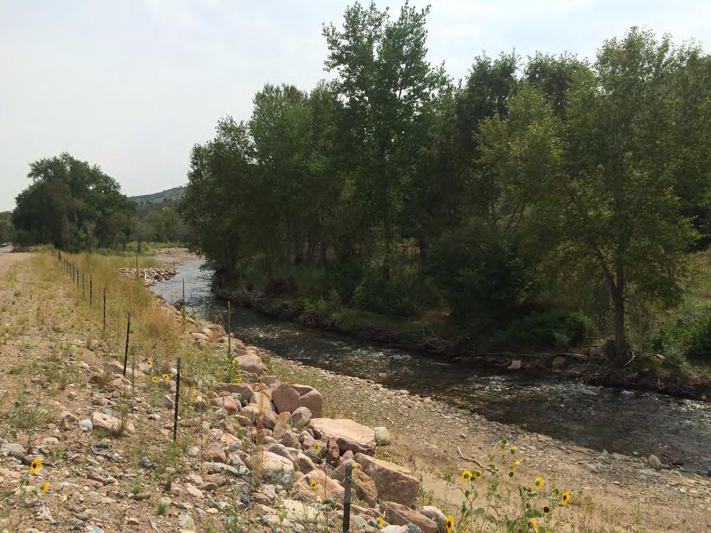
5 South St. Vrain / Hall Meadows Planning Area
6 South St. Vrain / Hall Meadows Management Plans and Assessments
7 County Assessments & Plans Boulder County Comprehensive Plan Environmental Resource Element (2014) Hall Ranch Meadows Natural Resource Assessment (2005) St. Vrain Creek Open Space Management Plan (2004) Environmental Assessment South St. Vrain Creek (2000) Resource Assessment Report Custode Property (2000) North Foothills Management Plan (1996)
8 Management Boulder County Comprehensive Plan Environmental Resources Element (2014) Critical Wildlife Habitat #7, St. Vrain Corridor Significant Natural Communities Riparian and Wetland Areas Riparian Habitat Connectors Preble s Meadow Jumping Mouse (PMJM) Habitat Conservation Area
9 Management St. Vrain Creek Corridor Open Space Management Plan Corridor designated as Natural and Agriculture The vision for the county open space properties along St. Vrain Creek is: Boulder County Parks and Open Space (BCPOS) responsibly and innovatively manages the County's water resources for diverse purposes. These resources are managed in an effective, sustainable, and efficient manner to support agriculture, provide quality visitor use opportunities, maintain viable riparian corridors, and for other environmental benefits. Stakeholders, government agencies, and BCPOS staff work together as stewards to ensure the protection and optimum utilization of these resources. (BCPOS 2004, p. 9)
10 Management North Foothills Management Plan Corridor designated as important bird habitat Some of the management goals include: Protect and properly manage Conservation Areas, Significant Plant Communities, and rare plants. Manage vegetative communities by maintaining and encouraging desirable native species, restoring degraded areas, and eliminating or controlling undesirable exotic species. Manage for ecosystem integrity by encouraging and planning for naturally occurring processes, or the simulation of those processes, so they will remain vital components of the ecosystem. The management direction is toward protecting critical resources, encouraging native species over exotic, and maintaining natural processes. Where feasible, a passive approach of letting nature take its course will be utilized (p. 19)
11 Post-Flood Work
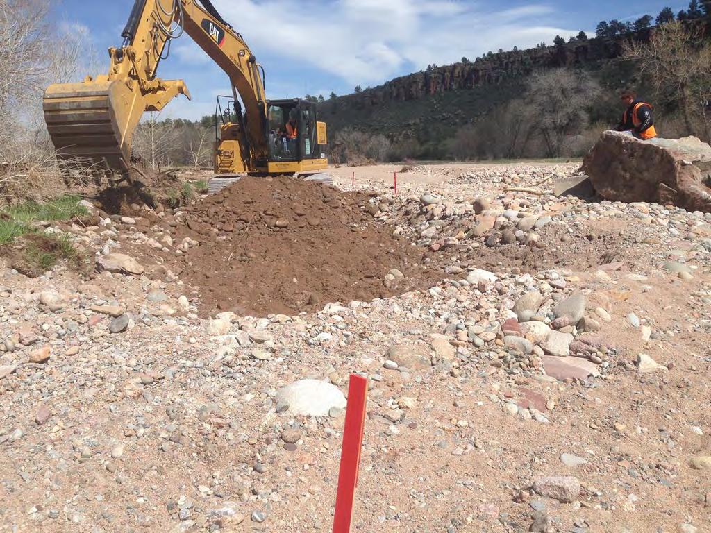
12

13 Hall II Lyons Quarry Post-Flood / Pre-Clean Up

14 Hall II Lyons Quarry Post-Flood / Pre-Clean Up

15 Hall II Lyons Quarry

16 Hall II Lyons Quarry

17 Hall II Lyons Quarry

18 Hall II Lyons Quarry

19 Hall II Access Road (FEMA)

20 Andesite Bridge (FEMA BC Transportation)
21 Andesite Bridge (FEMA BC Transportation)
22

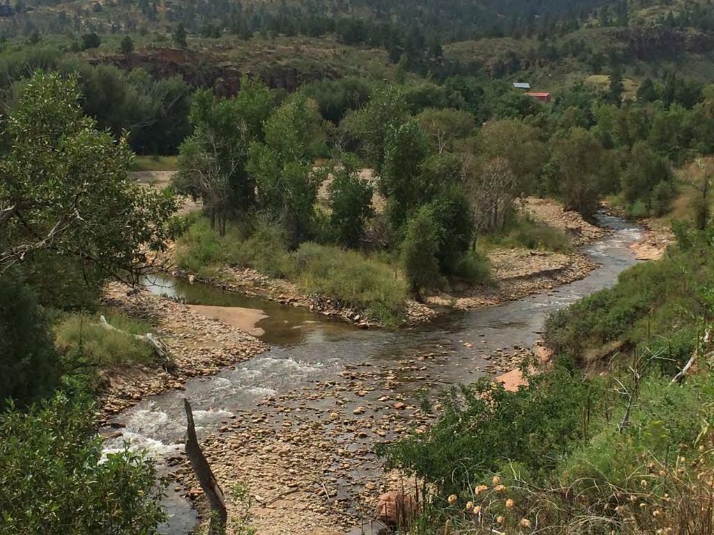
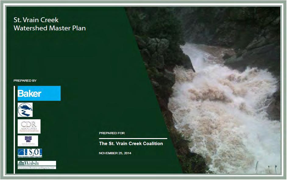
23 Secondary Channel Spring 2014
24 Secondary Channel October 2014

25 Secondary Channel August 2015

26 Secondary Channel August 2015

27 South Ledge & Meadows Diversion
28
29
30 St. Vrain Creek Watershed Master Plan Prepared through the St. Vrain Creek Coalition Adopted by Board of County Commissioners on February 26, 2015 Roadmap for long-term recovery Geomorphic Assessments Ecological Assessments Conceptual-level Designs Prioritization
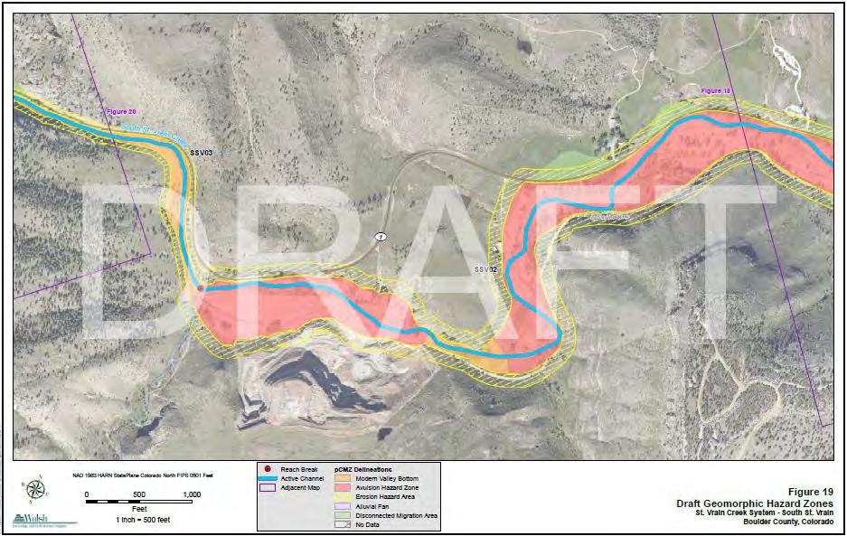
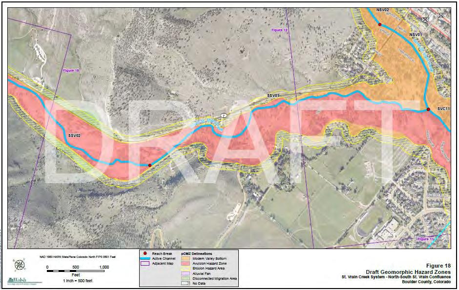
31 Geomorphic Assessment Due to the nature of the South St. Vrain Creek (slope, channel characteristics, bed material, etc.) the channel will tend to migrate and avulse for a range of hydrologic conditions. Absent of large flow events, the channel plan form for these reaches will likely remain reasonably stable once stream bank vegetation has re-established. However, beyond some threshold discharge the channel plan form can be expected to change, and in some instances change significantly due to avulsion and migration. Consequently, it is recommended that in most instances along South St. Vrain Creek that the channel be left in the current (post-flood) alignment In areas where it may be necessary to reclaim limited amounts of private property or protect infrastructure (including bridges, roadways and utilities), minor realignment of the main channel may be necessary. In addition, the use of localized rock riprap bank protection is recommended to stabilize local sections of the channel where necessary. However, it should be recognized that in these reaches it will not likely be possible to stabilize the channel plan form over long reaches, for a range of high flow conditions. (pp. 4-5) St. Vrain Creek Watershed Master Plan: Quantification of Geomorphic Parameters, Anderson Consulting, Inc., August 7, 2014
32 Geomorphic Assessment At the mouth (near the gravel quarry upstream of Lyons) the valley slope significantly flattens, the channel becomes unconfined and the South St Vrain becomes a highly depositional rifflepool gravel dominated C-type channel with a propensity for braiding and meandering. (p. 6) Geomorphic Assessment of St. Vrain Creek System, Walsh Environmental, July 28, 2014
33
34
35 Geomorphic Assessment Channelization (straightening) and stream bank armoring occurs throughout the St. Vrain Creek system. The response of the stream system to these modifications typically occurs within and beyond the modified reach and frequently begins with a bed incision process. As channels incise or berms are constructed, channels are disconnected from their floodplains, and in turn, the excess energy in the system causes an increase in erosion laterally and/or vertically. The increased erosion leads to an increase in sediment load transferred downstream of the channelized reach, where the channel may not have the capacity to continue to move the sediment through, ultimately leading to bed aggradation. (p. 14) Geomorphic Assessment of St. Vrain Creek System, Walsh Environmental, July 28, 2014
36 Geomorphic Assessment When possible the St. Vrain Coalition should seek to maintain a naturally meandering stream with frequent opportunities for floodplain access. (p. 14) Floodplains play an important role in dissipating stream energy and provide low-risk locations for natural sediment deposition in addition to providing ecological complexity and good riparian habitat. (p. 14) Geomorphic Assessment of St. Vrain Creek System, Walsh Environmental, July 28, 2014
37 Geomorphic Assessment Overflow channels and flood chutes carved though the floodplains during the 2013 flood provide opportunities for seasonal floodplain access. It is recommended that the St. Vrain Coalition prioritize protecting and restoring these locations as well as the wider channel corridor from the impacts of development, in order to reap the multiple benefits of increased flood protection and improved stream health provided by floodplain access and seasonal side channels. (p. 14) Geomorphic Assessment of St. Vrain Creek System, Walsh Environmental, July 28, 2014
38 Ecological Assessment SSV02 = Old St. Vrain Road bridge to quarry Channel Condition = 3 Hydrologic Alteration = 7 Bank Condition = 2 Riparian Quantity = 3 Riparian Quality = 1 Canopy Cover = 1 Nutrient Enrichment = 10 Manure or Septic = 10 Pools = 1 Barriers to Movement = 10 Fish Habitat Complexity = 4 Aquatic Invertebrate Habitat = 5 Total = 4.8 (POOR) Table 3, Page 8, Rapid Ecological Assessment of St. Vrain Creek Corridor, Walsh Environmental, July 15, 2014
39 Ecological Assessment Recommendation SSV02: Develop sediment transport/channel alignment plan through this reach; regrade floodplain while keeping floodplain access; protect as depositional reach Table 4, Page 9, Rapid Ecological Assessment of St. Vrain Creek Corridor, Walsh Environmental, July 15, 2014
40 St. Vrain Creek Watershed Master Plan Tier 1 - Projects reducing flood risk due to post-flood conditions Natural channel design Provide protection of infrastructure including ditches, homes, roads, and the town of Lyons Ecological restoration
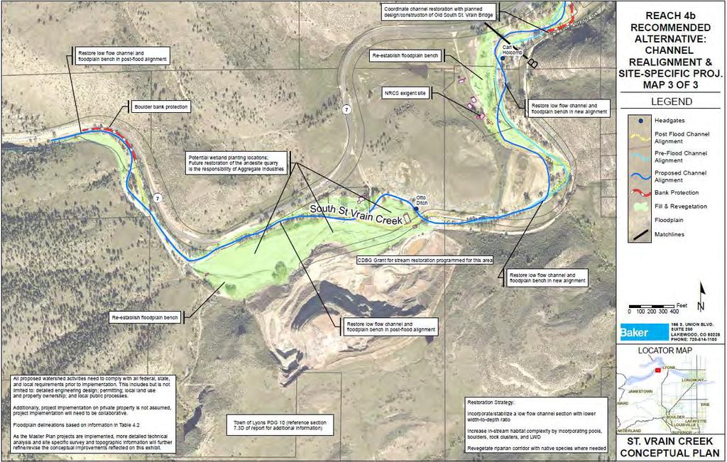
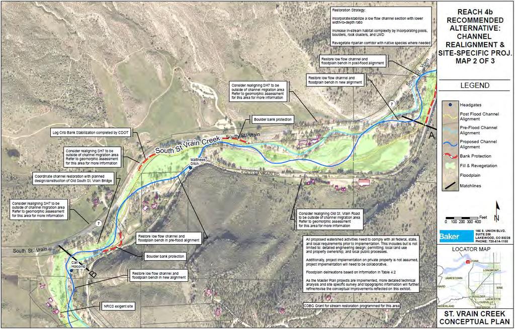
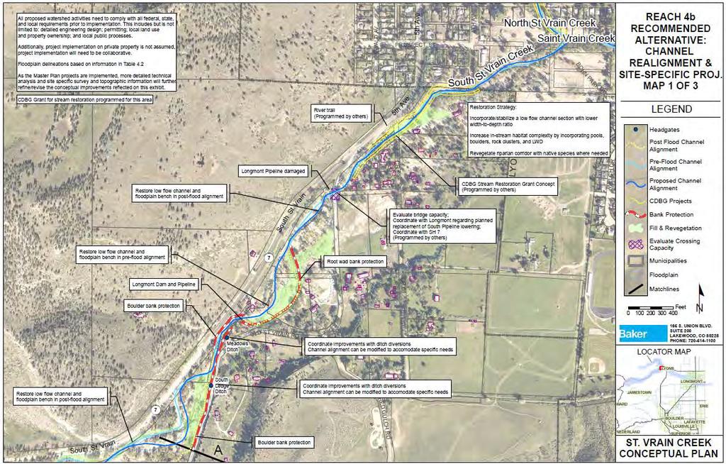
41 St. Vrain Creek Watershed Master Plan The purpose of this alternative is to implement a channel alignment that will optimize the interaction with completed, ongoing, and funded projects while being sensitive to the constraints presented by the presence of numerous private residences throughout this river corridor. The implementation of this alternative will expedite the maturation of this reach by re-establishing a natural channel, repairing erosion scars, re-establishing floodplain benches, building point-bars and excavating pools, re-vegetating denuded areas, and stabilizing channel banks. (p. 7-18).
42
43
44

45 Master Plan Cost Estimate BCPOS Estimated Total Cost = $5.6 million (removed fill, reduced revegetation, less bank protection)
46 Funding to Date Colorado Water Conservation Board - CWCB Stream Restoration Grant = $110,000 Planning, design, and demonstration project Community Development Block Grant Disaster Relief (CDBG-DR) Colorado Watershed Resilience Planning Grant Program = $295,000 Planning, engineering, surveys, and up to 30% design
47 CDBG-DR Project Scope Location: 3.2 mile stretch of the South St. Vrain Creek Custode to the end of the Hall Ranch property at Old St. Vrain Road bridge Public and private lands The project will consist of: engineering analysis and surveys, including hydraulics, geomorphological and sediment transport studies 30% design (preliminary)
48 South St. Vrain / Hall Meadows Planning Area
49 Technical Hydrology & Hydraulics Sediment Transport Environmental Resources Restoration Options & Prioritization Permitting (local, state, and federal) Implementation Grant Management Public Outreach

50 Harman, W., R. Starr, M. Carter, K. Tweedy, M. Clemmons, K. Suggs, C. Miller A Function- Based Framework for Stream Assessment and Restoration Projects. US Environmental Protection Agency, Office of Wetlands, Oceans, and Watersheds, Washington, DC EPA 843-K
51 CDBG-DR Grant Timeline Grant Contract (September-October 15) Request for Proposal (90 days from contract) Engineering and Surveys (winter summer 16) Design - Alternatives & Priorities (summer-fall 2016) Implementation including Permitting and Construction TBD * Public, SVCC, and other stakeholder outreach and input at various points throughout project
52 Future Projects PROJECTS DEPENDANT ON FUTURE FUNDS Potentially prioritize projects: Protect infrastructure in the reach between the Andesite Quarry & Old St. Vrain Road bridges Ecological values
53 Design Considerations
54 Design Considerations Maintain natural creek processes Resilience measures where appropriate: natural stream design to increase bank & channel stability a reduction in maximum flow velocity through increased floodplain connectivity other mitigation measures as appropriate Restore and protect habitat low flow channel with a lower width-to-depth ratio increased in-stream habitat complexity revegetation with native species Channel realignment at specific locations if necessary

55 Design Considerations Private Homes, Property, and Infrastructure Downstream Impacts Roadways Bridges Ditches Conveyance Debris/Hazards Other Studies $$$$


56 Design Considerations Questions, Ideas, Concerns What are your priority areas? What considerations are we missing?
Project Goals and Scoping
 Prepared for: Boulder County, Colorado Flood Planning & Preliminary Design Services for South St. Vrain Creek Restoration at Hall Ranch and Scoping May 24, 2016 Meeting with General Public In association
Parks and Open Space 5201 St. Vrain Road Longmont, Colorado Fax:
 Parks and Open Space 5201 St. Vrain Road Longmont, Colorado 80503 303.678.6200 Fax: 303.678.6177 www.bouldercounty.org HALL RANCH 2 ACCESS ROAD REPAIRS Project Summary for Limited Impact Special Use Review
IMPROVING OUTCOMES FOR STREAM ALTERATION PROJECTS
 IMPROVING OUTCOMES FOR STREAM ALTERATION PROJECTS Bethany Matousek Inland Lakes and Streams Program Coordinator Wetlands, Lakes and Streams Unit DEQ Water Resources Division MatousekB@Michigan.gov 517-243-6421
EcoStream Getting Our Feet Wet at Every Stage: Optimizing the Restoration of Urban Streams August 16, 2018
 EcoStream 2018 Getting Our Feet Wet at Every Stage: Optimizing the Restoration of Urban Streams August 16, 2018 Presentation Outline Planning/Design challenges, approaches, optimization Public Outreach/Stakeholder
Natural Channel Design and Dead River Case Study Stream Restoration in the Great Lakes Basin: Using In-stream Structures & Natural Channel Design
 Natural Channel Design and Dead River Case Study Stream Restoration in the Great Lakes Basin: Using In-stream Structures & Natural Channel Design January 22, 2013 S. Paige Baker, PE, MLE Presentation Outline
SHORELINE INVENTORY AND RESTORATION PLANNING
 CHAPTER 3 SHORELINE INVENTORY AND RESTORATION PLANNING A. PURPOSE OF THE SHORELINE INVENTORY AND CHARACTERIZATION A first step in the comprehensive Master Program update process is development of a shoreline
Logan River at Rendezvous Park, Channel and Floodplain Restoration: Crack Willow (Salix fragilis) Issues and Management Strategies
 Issues and Management Strategies") Logan River at Rendezvous Park, Channel and Floodplain Restoration: Crack Willow (Salix fragilis) Issues and Management Strategies Prepared May 2, 2017 by Darren Olsen, BIO-WEST, Inc. Issues Crack willow
Logan River at Rendezvous Park, Channel and Floodplain Restoration: Crack Willow (Salix fragilis) Issues and Management Strategies Prepared May 2, 2017 by Darren Olsen, BIO-WEST, Inc. Issues Crack willow
Use of WARSSS in Stream Restoration and Watershed Planning. Michigan Aquatic Restoration Conference 2015
 Use of WARSSS in Stream Restoration and Watershed Planning Michigan Aquatic Restoration Conference 2015 October 22, 2015 Use of WARSSS in Stream Restoration and Watershed Planning 1. Watershed Management
Table D1: WC-R1 to WC-R3 (Wilket Creek Park)
") APPENDIX D Table D1: WC-R1 to WC-R3 (Wilket Creek Park) Category of Consideration Criteria Alternative 1 Do Nothing Alternative 2 Local Improvements Alternative 3 Channel Realignment Natural Geomorphic
APPENDIX D Table D1: WC-R1 to WC-R3 (Wilket Creek Park) Category of Consideration Criteria Alternative 1 Do Nothing Alternative 2 Local Improvements Alternative 3 Channel Realignment Natural Geomorphic
Watershed Hydrology: Go with the flow. Greg Jennings, PhD, PE
 Watershed Hydrology: Go with the flow Greg Jennings, PhD, PE jenningsenv@gmail.com Streams What are your CHALLENGES? Hydrology too much water Pollutants upstream and on-site Vegetation wrong plants, wrong
Colorado Water Conservation Board Flood Recovery Update
 Colorado Water Conservation Board Flood Recovery Update Chris Sturm Stream Restoration Coordinator Colorado Water Conservation Board chris.sturm@state.co.us ORGANIZATIONAL CHART GOVERNOR DEPARTMENT OF
May 15, Lower Squaw Creek Restoration Public Workshop. for The Friends of Squaw Creek Truckee River Watershed Council Sierra Nevada Conservancy
 Lower Squaw Creek Restoration Public Workshop for The Friends of Squaw Creek Truckee River Watershed Council Sierra Nevada Conservancy Prepared by: Mike Liquori May 15, 2008 Funding for this project has
Local Flood Hazard Mitigation Program. A framework for hazard mitigation in the NYC West of Hudson Water Supply Watersheds
 Local Flood Hazard Mitigation Program A framework for hazard mitigation in the NYC West of Hudson Water Supply Watersheds Flood Hazard Mitigation Defined 2 2 Presentation Overview Why and how is the NYC
URBAN STREAM RESTORATION BMP
 FREQUENTLY ASKED QUESTIONS: URBAN STREAM RESTORATION BMP OVERVIEW In May of 2013, the Water Quality Goal Implementation Team (WQGIT) approved the Final Recommendations of the Expert Panel to Define Removal
River Restoration in Iowa is there anything fishy going on here? or Fish Habitat in Iowa
 River Restoration in Iowa is there anything fishy going on here? or Fish Habitat in Iowa Jeff Kopaska Iowa Water Conference Ames, IA March 22, 2018 Where did we start? Lea, 1836 In every part of this whole
Municipal Class Environmental Assessment for Pottersburg Creek Slope Stability Study South of Hamilton Road, Schedule B
 Municipal Class Environmental Assessment for Pottersburg Creek Slope Stability Study South of Hamilton Road, Schedule B February 13, 2013 Municipal Class EA Process We are here Purpose and Objective of
Beaver Creek Hydrology, LLC. Franklin, Tennessee
 Beaver Creek Hydrology, LLC. Franklin, Tennessee The Harpeth River Blueway Problems with Harpeth River EPA s 303(d) Listed for siltation, habitat alteration, nutrient enrichment and low dissolved oxygen
Management Objectives and Targets
 Management Objectives and Targets As part of the Yampa River Stream Management Plan, the community of Steamboat Springs developed management objectives for the reach of the Yampa River near Steamboat Springs.
Understanding and Restoring Natural Floodplain Function. Gary James CTUIR Fisheries Program Manager
 Understanding and Restoring Natural Floodplain Function Gary James Fisheries Program Manager Future of Our Salmon Technical Workshop on Healthy Floodplains Spokane, WA - August 16-18, 2016 Presentation
Stream Restoration in the Urban Environment Concepts and Considerations
 Stream Restoration in the Urban Environment Concepts and Considerations The Restoration of Our Rivers; October 5, 2012 Matthew A. Van Eps, PE & Sandi J. Formica: Watershed Conservation Resource Center
POLICY FOR NATURAL RESOURCE MANAGEMENT AREAS
 POLICY FOR NATURAL RESOURCE MANAGEMENT AREAS I. POLICY STATEMENT Auburn University's (the University's) "Policy for Natural Resource Management Areas" implements the Campus Master Plan Land Use Element
Wood-Pawcatuck Watershed Flood Resiliency Management Plan Community Meeting October 20, 2016
 Wood-Pawcatuck Watershed Flood Resiliency Management Plan Community Meeting October 20, 2016 Wood-Pawcatuck Watershed Association Meeting Agenda 10:00 10:05 Introductions and Meeting Goals 10:05 10:15
RIPARIAN CORRIDOR STUDY FINAL CITY CREEK MANAGEMENT PLAN TABLE OF CONTENTS
 TABLE OF CONTENTS 1.0 INTRODUCTION... 1-1 Riparian Corridor Study and Management Plan Goals... 1-1 Study Area... 1-2 Importance and Functions of Riparian Corridors... 1-2 Habitat for Mammals, Birds, and
FREQUENTLY ASKED QUESTIONS: URBAN STREAM RESTORATION BMP. David Wood Chesapeake Stormwater Network. Lisa Fraley-McNeal Center for Watershed Protection
 FREQUENTLY ASKED QUESTIONS: David Wood Chesapeake Stormwater Network URBAN STREAM RESTORATION BMP Lisa Fraley-McNeal Center for Watershed Protection Bill Stack Center for Watershed Protection FREQUENTLY
Wood-Pawcatuck Watershed Flood Resiliency Management Plan
 Wood-Pawcatuck Watershed Flood Resiliency Management Plan Project Steering Committee Meeting May 21, 2015 Wood-Pawcatuck Watershed Association Meeting Agenda 10:00 10:05 Welcome and Opening Remarks 10:05
CHATHAM PARK EXCEPTIONAL DESIGN EVALUATION
 CHATHAM PARK EXCEPTIONAL DESIGN EVALUATION 1 Chatham Park Basics 7,600 Acre Mixed Use Development 22,000 New Residences 22 Million Square Feet Commercial Space 60,000 Jobs 2,000+ Acres Open Space Estimated
Wood Canyon Emergent Wetland Project. City of Aliso Viejo 12 Journey, Suite 100 Aliso Viejo, CA 92656
 Wood Canyon Emergent Wetland Project City of Aliso Viejo 12 Journey, Suite 100 Aliso Viejo, CA 92656 Introduction Wood Canyon is located within Aliso and Wood Canyon Regional Park in southwest Orange County,
Tribal Partnership Program Jamestown S Klallam Tribe and USACE Dungeness River in Washington State
 Tribal Partnership Program Jamestown S Klallam Tribe and USACE Dungeness River in Washington State Zac Corum, PE, Sr. Hydraulic Engineer, Seattle District USACE Randy Johnson, Habitat Program Manager (JSKT)
Public Information Centre September 19 th, 2017
 Public Information Centre September 19 th, 2017 WELCOME! Public Information Centre for the Maple Hill Creek Rehabilitation Class Environmental Assessment Please take the time to sign our sign in sheet
WHY ARE STREAM IMPROVEMENTS NEEDED IN TENNESSEE? TENNESSEE STREAMS
 WHY ARE STREAM IMPROVEMENTS NEEDED IN TENNESSEE? TENNESSEE STREAMS Most diverse aquatic fauna in the country Majority of West TN streams are channelized 36,000 miles of degraded stream are in need of restoration
STREAM RESTORATION PURPOSE, PRACTICE, AND METHODS. By Marcus Rubenstein, CPESC
 STREAM RESTORATION PURPOSE, PRACTICE, AND METHODS By Marcus Rubenstein, CPESC WHAT IS STREAM RESTORATION? The return of a stream s lost natural functions, usually resulting from watershed alterations,
The Lower Watershed Ecosystem Services in Coastal Areas with a focus on the Courtenay River Floodplain
 The Lower Watershed Ecosystem Services in Coastal Areas with a focus on the Courtenay River Floodplain Jennifer Sutherst Estuary Coordinator and Staff Biologist Comox Valley Project Watershed Society Lower
There is a reliable, clean water supply for current and future generations.
 E2 There is a reliable, clean water supply for current and future generations. E2.1. Current and future water supply for municipalities, industries, agriculture, and the environment is reliable. 2.1.1.
Meacham Creek Restoration Project
 Meacham Creek Restoration Project Meacham Creek Restoration Project Umatilla National Forest Walla Walla Ranger District Michael Rassbach, District Ranger Public Scoping Document Proposal Summary The Walla
The Nature Conservancy Cosumnes River Preserve Franklin Boulevard Galt CA 95632
 Study Partners The Nature Conservancy Cosumnes River Preserve 13501 Franklin Boulevard Galt CA 95632 East Bay Municipal Utility District 1 Winemaker Way, Unit K Lodi CA 95240 Sacramento County Water Agency
LITTLE SHADES CREEK RESTORATION PROJECT CWA Section 319(h) Nonpoint Source Implementation Grant Project Workplan #17 ADEM Contract #C
 Nonpoint Source Implementation Grant Project Workplan #17 ADEM Contract #C") LITTLE SHADES CREEK RESTORATION PROJECT CWA Section 319(h) Nonpoint Source Implementation Grant Project Workplan #17 ADEM Contract #C90593066 PARTNERS Alabama Department of Environmental Management Cawaco
LITTLE SHADES CREEK RESTORATION PROJECT CWA Section 319(h) Nonpoint Source Implementation Grant Project Workplan #17 ADEM Contract #C90593066 PARTNERS Alabama Department of Environmental Management Cawaco
Site Selection and Design for Stream Mitigation
 Site Selection and Design for Stream Mitigation Will Harman, PG Stream Mechanics The Association of State Wetland Managers State/Tribal/Federal Coordination Meeting March 19-21, 2013 NCTC Our Relationship
Introduction to stream assessment
 Why do stream assessment? Introduction to stream assessment Given the current condition of rivers and the heightened public interest in them, there is a significant need for the ability to determine the
Massachusetts River and Stream Crossing Standards: Technical Guidelines
 Massachusetts River and Stream Crossing Standards: Technical Guidelines August 6, 2004 INTRODUCTION As long and linear ecosystems, rivers and streams are very important for fish and other wildlife movements,
Appendix P. U.S. Fish and Wildlife Service Planning Aid Letter
 Appendix P U.S. Fish and Wildlife Service Planning Aid Letter This page is intentionally left blank. United States Department of the Interior FISH AND WILDLIFE SERVICE Missouri Ecological Services Field
ADDENDUM #1 RFP WOLFTRAP CREEK STREAM RESTORATION
 ADDENDUM #1 February 6, 2015 RFP 15-03 WOLFTRAP CREEK STREAM RESTORATION ******ATTENTION BIDDERS****** (To be completed and returned with bid response) A request was made that the Stormwater Local Assistance
PROJECT SCREENING MATRIX: A User s Guide
 Version 2.0 Page 1 of 7 November 9, 2010 PROJECT SCREENING MATRIX: A User s Guide BACKGROUND The Project Screening Matrix (Screening Matrix) is one of several tools that comprise the River Restoration
REPLACING CULVERTS FOR FLOOD RESILIENCY AND AQUATIC CONNECTIVITY. Cheryl Bondi and Lori Sommer NHDES Aquatic Resource Mitigation Program
 REPLACING CULVERTS FOR FLOOD RESILIENCY AND AQUATIC CONNECTIVITY Cheryl Bondi and Lori Sommer NHDES Aquatic Resource Mitigation Program How do stream crossings impact aquatic ecosystems and public safety?
Bridging the Gap to Resilience Western Bridge Preservation Partnership Denver, CO May 23, 2017
 Bridging the Gap to Resilience Western Bridge Preservation Partnership Denver, CO May 23, 2017 Presenter Heather Paddock, PE Region 4 Central Program Engineer and Flood Recovery Manager heather.paddock@state.co.us
RIPARIAN CORRIDOR STUDY FINAL PARLEYS CREEK MANAGEMENT PLAN TABLE OF CONTENTS
 TABLE OF CONTENTS 1.0 INTRODUCTION... 1-1 Riparian Corridor Study and Management Plan Goals... 1-1 Study Area... 1-2 Importance and Functions of Riparian Corridors... 1-2 Habitat for Mammals, Birds, and
Drainage Criteria Manual Review
 City of Colorado Springs Stormwater Management Assessment and Standards Development Drainage Criteria Manual Review March 8, 2013 Springsgov.com/City Agencies/Stormwater/Stormwater Engineering/ Stormwater
Toronto and Region Conservation 2017 Progress & 2018 Budget Peel Council
 Toronto and Region Conservation 2017 Progress & 2018 Budget Peel Council November 16, 2017 1 2 Input $4,248,000 44 Projects Activities Watershed 2017 Output Increased coverage of Flood Monitoring and Real
Stinson Beach Watershed Program
 Stinson Beach Watershed Program www.marinwatersheds.org Purpose The Board of Supervisors authorized the Department of Public Works to begin implementation of a County-wide Watershed Program on May 13,
The Beckett s Run Experience. Fort Wayne, Indiana
 The Beckett s Run Experience Fort Wayne, Indiana Introductions Charlie Cochran City of Fort Wayne, Wet Weather Storm & Sewer Engineering Jason Durr, PE Christopher B. Burke Engineering, LLC 2 A Little
Reclaiming Seiad Creek Part 1
 Reclaiming Seiad Creek Part 1 After 100+ Years of Placer Mining Presented by: Jason E. Poulsen May 4, 2016 Montana Tech Mine Design, Operation & Closure Conference Badges? We ain t got no badges... We
Stream Restoration Verification Guidance
 Stream Restoration Verification Guidance Version: Final, February 6 th, 2014 The guidance is revised to incorporate comments provided by the Chesapeake Bay Program Verification Review Panel (CBP Water
Wood-Pawcatuck Watershed Flood Resiliency Management Plan
 Wood-Pawcatuck Watershed Flood Resiliency Management Plan Project Steering Committee Kickoff Meeting March 26, 2015 Wood-Pawcatuck Watershed Association Meeting Agenda 10:00 10:05 Welcome and Opening Remarks
Assessing Stream Functions for Watershed Management in Oregon. Dana Hicks, Mitigation Policy Specialist Oregon Department of State Lands
 Assessing Stream Functions for Watershed Management in Oregon Dana Hicks, Mitigation Policy Specialist Oregon Department of State Lands ASWM State/Tribal/Federal Coordination Meeting April 12, 2018 How
STREAMBANK RESTORATION DESIGN
 STREAMBANK RESTORATION DESIGN WITH VINYL SHEET PILE GRADE CONTROL STRUCTURES BRUCE M. PHILLIPS, M.S., P.E. ABSTRACT Grade control structures are an effective channel stabilization measure which can eliminate
Floodplain Restoration with Large Wood
 Floodplain Restoration with Large Wood Caitlin Alcott, CE, CFM ASFPM Conference June 21, 2016 Overview: 1. Functions of large wood in rivers and floodplains 2. Human impacts on large wood dynamics 3. Design
Sustainable Disaster Recovery Within a Dynamic Watershed: A Colorado Flooding Case Study
 Sustainable Disaster Recovery Within a Dynamic Watershed: A Colorado Flooding Case Study Jeff Brislawn, AMEC Environment and Infrastructure ASFPM Annual Conference 2014 Presentation Outline The event of
Lake Samish Comprehensive Stormwater Plan Capital Improvement Recommendations
 Lake Samish Comprehensive Stormwater Plan Capital Improvement Recommendations drainage. The easement could potentially be used to site a surface water quality treatment facility for the flow. The design
NCS Design Approach. Biology/Ecology Primer. Presented by: Jack Imhof, National Biologist Trout Unlimited Canada
 NCS Design Approach Biology/Ecology Primer Presented by: Jack Imhof, National Biologist Trout Unlimited Canada Biology/Ecology Key biological principles that are applied Need to speak the same language
Urban Riparian & Stream Restoration Program: Management & Photo Monitoring. Texas Water Resource Institute
 Urban Riparian & Stream Restoration Program: Management & Photo Monitoring Texas Water Resource Institute Hindrances to Healthy / Functional Riparian Areas: Farming too close to the bank Mowing, spraying
Clallam County Shoreline Master Program Update
 Clallam County Shoreline Master Program Update Board of Commissioners Work Session November 13, 2017 Topics Buffers Channel Migrations Zones (CMZs) Mitigation and No Net Loss Importance of Buffers Provide
Chehalis Basin Strategy Programmatic SEPA Draft EIS
 Chehalis Basin Strategy Programmatic SEPA Draft EIS History of Flooding I-5 closed in 1990, 1996, 2007, 2009 Five largest flood events occurred since 1986 2 History of Habitat Degradation Harvest has been
The Salt River Ecosystem Restoration Project Phase 2 Design Update
 The Salt River Ecosystem Restoration Project Phase 2 Design Update Prepared for: Humboldt County Resource Conservation District & Salt River Watershed Council Prepared by: Jeremy Svehla, PE Conor Shea,
F7 Stream Reach Summary
 F7 Stream Reach Summary Study Reach: F7, Fraser River - Ranch Creek confluence downstream to Canyon below Strawberry Road. Reach Description: Approximate channel length: 1 ½ miles, approximate channel
DRAFT-2 1/31/2004. Memorandum of Understanding
 DRAFT-2 1/31/2004 Memorandum of Understanding The following points of agreement between the Army Corps of Engineers and the Resource Agencies provide the parameters for the continued development of a NED
Request for Proposal Scope Development Guide. Asotin County Geomorphic Assessment. and. Conceptual Restoration Plan
 Request for Proposal Scope Development Guide Asotin County Geomorphic Assessment and Conceptual Restoration Plan Asotin County Conservation District December 3, 2015 1 1.0 INTRODUCTION The Asotin County
TABLE OF CONTENTS. TOC-i
 TOC-i TABLE OF CONTENTS 1.0 INTRODUCTION... 1-1 Riparian Corridor Study and Management Plan Goals... 1-1 Study Area... 1-2 Importance and Functions of Riparian Corridors... 1-2 Habitat for Mammals, Birds,
Burke Creek Restoration Potential and Design Concepts. Final Memorandum
 Burke Creek Restoration Potential and Design Concepts For Portions Both Inside and Outside the Sierra Colina Parcel and for Consideration in the TRPA Burke Creek EIP #161 Study Final Memorandum Prepared
Walnut Creek Watershed Management Authority. Project Kick Off March 18, 2015
 Walnut Creek Watershed Management Authority Project Kick Off March 18, 2015 Agenda Schedule & Meeting Purpose Meeting Purpose TMDL Raccoon River TMDL Impaired by Nitrate and E.coli Includes Walnut Creek
Restoration of Riparian Forests and Riparian Ecosystem Processes and Implications for Salmon Restoration. Katie Ross-Smith Jennifer Hammond
 Restoration of Riparian Forests and Riparian Ecosystem Processes and Implications for Salmon Restoration Katie Ross-Smith Jennifer Hammond Outline > Background California riparian communities Riparian
MONTEREY PENINSULA WATER MANAGEMENT DISTRICT PROJECT DESCRIPTION FOR SELECTIVE VEGETATION MANAGEMENT AND BANK RESTORATION (RANCHO SAN CARLOS AREA)
") MONTEREY PENINSULA WATER MANAGEMENT DISTRICT PROJECT DESCRIPTION FOR SELECTIVE VEGETATION MANAGEMENT AND BANK RESTORATION (RANCHO SAN CARLOS AREA) IN THE CARMEL RIVER CHANNEL, SUMMER AND FALL 2014 SELECTIVE
MONTEREY PENINSULA WATER MANAGEMENT DISTRICT PROJECT DESCRIPTION FOR SELECTIVE VEGETATION MANAGEMENT AND BANK RESTORATION (RANCHO SAN CARLOS AREA) IN THE CARMEL RIVER CHANNEL, SUMMER AND FALL 2014 SELECTIVE
Burke Creek Highway 50 Crossing and Realignment Project Monitoring Plan
 Burke Creek Highway 50 Crossing and Realignment Project Monitoring Plan Table of Contents Table of Figures... i Introduction... 1 Background... 1 Burke Creek Issues... 2 Monitoring Objectives and Goals...
GETTING STARTED: LEVERAGING FUNDING SOURCES TO CREATE OPPORTUNITIES KAMM CONFERENCE August 24, 2016 Presented By: Sarah Taylor
 GETTING STARTED: LEVERAGING FUNDING SOURCES TO CREATE OPPORTUNITIES 2016 KAMM CONFERENCE August 24, 2016 Presented By: Sarah Taylor OVERVIEW Do I really have a problem? Identifying the need Finding the
Step-Pool Creation to Restore Fish Passage and Riparian Health
 Step-Pool Creation to Restore Fish Passage and Riparian Health Jenny Kindig Water Resources Engineer Denny Mengel, Senior Environmental Scientist Steve Miller, Water Resources Engineer Gloria Beattie,
Appendix B Stormwater Site Plan Submittal Requirements Checklist
 Stormwater Site Plan Submittal Requirements Checklist The Submittal Requirements Checklist is intended to aid the design engineer in preparing a Stormwater Site Plan. All items included in the following
F5 Stream Reach Summary
 F5 Stream Reach Summary Study Reach: F5, Fraser River - Town of Fraser at Meadow Ridge Road downstream to the Consolidated Wastewater Treatment facility downstream of County Road 8. Reach Description:
Mike Jastremski, CFM Watershed Conservation Director
 Planning for Flood Resilient and Fish Friendly Road-Stream Crossings in CT s Northwest Hills Mike Jastremski, CFM Watershed Conservation Director Presentation Outline Project area Climate threats Field
Ingram Gulch Drainage 30% Design Report
 Ingram Gulch Drainage 30% Design Report Submitted to: Four Mile Watershed Coalition Project Number: 970-1 Date: March 13, 2017 Norwest Corporation 950 South Cherry Street, Suite 800 Denver, Colorado 80246
Plan Rollout Presentation July 31, Michael G. Hahn, P.E., P.H. Chief Environmental Engineer. Southeastern Wisconsin Regional Planning Commission
 Plan Rollout Presentation July 31, 2014 Michael G. Hahn, P.E., P.H. Chief Environmental Engineer Southeastern Wisconsin Regional Planning Commission # 219703 Racine County Flooding Recommendations and
Stream Restoration at Road Crossings in Northern Wisconsin. Dale Higgins, USDA Forest Service
 Stream Restoration at Road Crossings in Northern Wisconsin Dale Higgins, USDA Forest Service Key Points Large # of road and trail stream crossings on the landscape Many crossings adversely impact streams
Ecohydrology Research Vision. SCCWRP Commission Meeting December 4, 2015
 Ecohydrology Research Vision SCCWRP Commission Meeting December 4, 2015 Roadmap for Today What is Ecohydrology? Why is Ecohydrology important? How does SCCWRP s Ecohydrology research vision relate to policy
TRCA Natural Channel Design Monitoring Program. SOSMART Group Meeting December 7, 2010
 TRCA Natural Channel Design Monitoring Program SOSMART Group Meeting December 7, 2010 Natural Channel Design (NCD) Reconstruction of a stream channel and floodplain using techniques to restore or replicate
Sustainable Post Disaster Recovery
 Sustainable Post Disaster Recovery May 14, 2013 4 PM Lucinda Andreani & Dustin Woodman Coconino County Public Works (Arizona) 1 Presenters Lucinda Andreani, Deputy Director, Coconino County Public Works
7.0 WATER-BASED CONTROL MEASURES
 7.0 WATER-BASED CONTROL MEASURES 7.1 IDENTIFICATION AND DESCRIPTION OF CONTROL MEASURES Table 7-1 lists the water-based options being considered for implementation in the initial screening stage. Descriptions
Environment and Natural Resources Trust Fund 2015 Request for Proposals (RFP)
") Project Title: Total Project Budget: $ Environment and Natural Resources Trust Fund 2015 Request for Proposals (RFP) Flood Recovery on Sargent Creek Duluth Habitat Restoration Category: Proposed Project
Project Title: Total Project Budget: $ Environment and Natural Resources Trust Fund 2015 Request for Proposals (RFP) Flood Recovery on Sargent Creek Duluth Habitat Restoration Category: Proposed Project
CHESAPEAKE BAY COMPREHENSIVE WATER RESOURCES AND RESTORATION PLAN. Habitat GIT Meeting 9 May 2017
 CHESAPEAKE BAY COMPREHENSIVE WATER RESOURCES AND 255 255 255 237 237 237 0 0 0 217 217 217 163 163 163 200 200 200 131 132 122 239 65 53 80 119 27 RESTORATION PLAN 110 135 120 252 174.59 112 92 56 62 102
CROSBY BROOK RESTORATION STUDY BRATTLEBORO, VT
 Key Stakeholders: CROSBY BROOK RESTORATION STUDY BRATTLEBORO, VT Funded By: VT Dept. of Environmental Conservation VT Agency of Transportation (VTrans) Town of Brattleboro NEWEA Spring Meeting Omni Mt.
COTTON CREEK CULVERT REPLACMENT
 COTTON CREEK CULVERT REPLACMENT Integrating Mobility with Environmental Innovation Located along a scenic section of Highway 3/95 in British Columbia, Moyie Bluffs, a 6.5 km stretch of inland highway had
Moonlight Aquatic Organism Passage Project
 Notice of Proposed Action Moonlight Aquatic Organism Passage Project Mt. Hough Ranger District Plumas National Forest Plumas County, California Figure 1. Hungry 1 aquatic organism passage outlet showing
COON CREEK WATERSHED DISTRICT PERMIT REVIEW. Spring Lake Park Schools Westwood Middle School st Avenue NE, Spring Lake Park, MN 55432
 PAN 16-112, Westwood Middle School, Page 1 of 6 COON CREEK WATERSHED DISTRICT PERMIT REVIEW MEETING DATE: August 22, 2016 AGENDA NUMBER: 10 FILE NUMBER: 16-112 ITEM: Westwood Middle School RECOMMENDATION:
INDIAN CREEK WATERSHED PLAN EXECUTIVE SUMMARY
 INDIAN CREEK WATERSHED PLAN EXECUTIVE SUMMARY The Indian Creek Watershed covers a 38 square mile area in southern Lake County, Illinois that drains 24,116 acres before discharging into the Des Plaines
D Olive Watershed. Path Toward Restoration
 D Olive Watershed Path Toward Restoration Water is the most critical resource issues of our lifetime and our children s lifetime. The health of our waters is the principal measure of how we live on the
Stream Simulation in Very Low Gradient Channels
 University of Massachusetts - Amherst ScholarWorks@UMass Amherst International Conference on Engineering and Ecohydrology for Fish Passage International Conference on Engineering and Ecohydrology for Fish
Bluff Creek One Water
 Bluff Creek One Water The Bluff Creek Watershed has no lakes within its boundaries. As the westernmost watershed within the District, land use changes from agricultural to residential have occurred relatively
Surface Water. Solutions for a better world
 1 Surface Water Solutions for a better world Our Surface Water Services Expertise Growing worldwide awareness of water scarcity has encouraged water preservation programs, better irrigation techniques
Don Catchment Vision
 Don Catchment Vision Don Catchment Vision A healthy and biodiverse catchment that is valued and enjoyed, contributing to the economic and social well-being of local communities. Aims for the Don To identify
Conceptual Design and Feasibility of a Natural Fishway at the Fremont BART Weir, Alameda Creek, California
 Conceptual Design and Feasibility of a Natural Fishway at the Fremont BART Weir, Alameda Creek, California Final Report September 2005 Prepared by Center for Ecosystem Management and Restoration, Oakland,
BASIC PRINCIPLES AND MANAGEMENT GUIDELINES
 Chapter 1 BASIC PRINCIPLES AND MANAGEMENT GUIDELINES The overall goal of the management program for the Sacramento River Conservation Area (SB 1086) is to preserve remaining riparian habitat and reestablish
COTTONWOOD CREEK RECLAMATION PHASE I & II
 COTTONWOOD CREEK RECLAMATION PHASE I & II COTTONWOOD CREEK RECLAMATION Stream Stabilization Approach to Urban Runoff Quality Cherry Creek Basin Water Quality Authority The Problem The Cherry Creek Reservoir
Meacham Creek Fish Habitat Enhancement: Application of the CTUIR River Vision
 Meacham Creek Fish Habitat Enhancement: Application of the CTUIR River Vision Future of Our Salmon A Vision of Restoration in the Columbia River Basin June 1, 2011 James Webster Confederated Tribes of