Bond release verification requirements for successful reclamation at Wyoming surface coal mines
|
|
|
- Josephine Gilmore
- 6 years ago
- Views:
Transcription

1 Bond release verification requirements for successful reclamation at Wyoming surface coal mines Dr. Anna Krzyszowska Waitkus Coal bond release procedure in Wyoming Coal bond release verification criteria and performance standards Tracking bond release at a large Wyoming coal mining operation 1


2 41% of USA total coal production comes from Wyoming Million tons, 2015 North Antelope Rochelle Mine (NARM) 2

3 Reclamation bond The Federal, Surface Mining Control and Reclamation Act (SMCRA) requires as a condition for obtaining a coal mining permit posting a reclamation performance bond to ensure that: - regulatory authority will have sufficient funds to reclaim the site if the permittee fails to complete the reclamation plan approved in the permit. - regulatory authority will have sufficient funds to hire a third party to complete the reclamation plan in the event of a bankruptcy of the coal mine company. 3
4 Total bond for minerals mined in Wyoming (November 2014) Mineral Bond, $ % Coal, 35 coal mines 2,828,871, Uranium 375,450, Trona 149,516,450 4 Bentonite 70,432,273 2 Sand & gravel, granite, limestone, sandstone, clay, decorative rock, diamonds, dolomite, feldspar, gravel, gypsum, iron, jade, leonardite, opal, quartzite, sand, scoria, shale 42,694,405 1 Total 3,466,964,
5 Reclamation bond The permittee may apply for bond release through incremental bond release phases as the permittee completes phases of reclamation. Wyoming Department of Environmental Quality (WDEQ), Land Quality Division (LQD) approves reclamation bond submitted by the permittee through Annual Reports. Bond release - reduction of the reclamation bonds and the financial risk to the public. 5
6 Wyoming reclamation bond release procedures There are two steps to release a bond: 1. Verification and evaluation of bond release criteria and performance standards for reclaimed areas. 2. Reclamation bond release approval of areas that were verified. 6
7 Bond release phases and bond release verification criteria, WY Each of the bond release phases has certain criteria and performance standards (permit commitments) that must be met before the bond is released. Bond release phases Area Bond Verification of the bond release criteria Backfilling, regrading completed according to the approved plan 60% 15% Phase 1 Phase 2 Phase 3 Stream channels reconstructed Soil applied Vegetation established (ocular evaluation) Surficial stability established Permanent impoundment construction/renovation designed and State Engineer Office approved Revegeation success standards established (statistical analysis) 25% Mitigation of wetlands (approved by the US Army Corps of Engineers) Trees established 7
8 Reclamation bond release procedures How this is done at the State of Wyoming? 1. Bond release verification request for specific areas (submittals by the operator) - inspections by the WDEQ/LQD of the requested area - reviews of the submitted information - approval of the request within 60 days from the submittal 2. Bond release request for areas that have already been verified. - declaration of completion within 15 days from the approved submittal. 3. After approval by the WDEQ/LQD - the public is notified. - public notice asking for comments/objections is published in a local newspaper at least once per week for four consecutive weeks. 4. WDEQ/LQD, OSMRE (federal agency) representatives, and the land owners perform the inspection of the bond release requested areas together. 5. Reclamation bond release for requested areas is approved. 8
9 Cooperative effort: Wyoming guidelines, bond release - WDEQ/LQD - coal industry - Office of Surface Mining, Reclamation and Enforcement (OSMRE) - consultants - Guideline No Bond Release Categories and Submittal Procedures for Coal Mines - Guideline No. 21 Area Bond and Rough Backfill Verification Procedures for Coal Mines - Guideline No Verification for Phase 1 Bond Release for Coal Mines - Guideline No. 23 Verification fro Phase 2 Bond Release Procedures for Coal Mines - Guideline No. 25 Verification for Phase 3 Bond Release Procedures for Coal Mines 9
10 Bond release verification procedures What? How? Verification of the: - criteria - performance standards Field inspections Annual reports Reviews 10
11 Area Bond Rough Backfill verification - As built map demonstrating acceptable postmining topography (PMT). - Elevation tolerance (reclaimed elevation are within +/- 20 feet of the approved PMT). - Drainage divides match those of the approved PMT. - Hill slopes lengths and profiles (complex hill slope profile). - Valley bottom alignment, slopes and profile (generally flattening in a downstream direction). - Special commitments (Alluvial Valley Floors construction). 11


12 Area Bond Rough backfill verification Approximate Original Contour 12

13 Phase 1- Stream Channels Reconstruction - Permanent diversions and restored stream channels have been constructed per approved designs and are stable (no erosion). - Rebuilt drainages must meet the premine drainage elevations and must tie-in to existing drainages in the surrounding native areas. - Rebuilt all suitable channel morphology (gradients, lengths, profiles, sinuosity) for all channels with a drainage area greater than 50 acres. - No depression >0.5 acre-ft. unless approved. - Suitable backfill quality in drainage channels and floodplains. 13


14 Phase 1- Stream Channel Reconstruction Verification - During the inspection, the reconstructed Porcupine Creek was surveyed by the LQD inspector using a handheld Geographic Positioning System (GPS) unit. - The surveyed channel was overlaid on the permit map to compare the restored location of the creek to the original channel. - Results were very good. 14


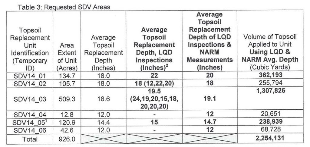


15 Phase 1 Soil depth verification 15


 has")
16 Phase 2 Verification of: - ocular vegetation establishment - surficial stability Phase 1 Phase 2 - permanent water impoundment construction - Verified if the surface landowner has consented. - Verified if State Engineer s Office (SEO) has approved the impoundment for its intended use. 16
17 Phase 3- verification submittals Approved postmining land uses have been restored Achievement of the revegetation performance standards Achievement of the shrub stablishment goals and/or standards Achievement of the tree replacement standards Successful restoration of wildlife habitat Postmining ground water supports the approved postmining land uses Postmining surface water quality and quantity support the approved postmining land use and minimize impacts to the hydrologic balance All approved postminng road types and corridors are in place and functional in support of approved postminng land uses Removal of all temporary structures 17
18 Phase 3 - achievement of the revegetation performance standards Requirements Goals, standards Vegetation Vegetation sampling Species composition/diversity Production and cover estimated on reclaimed areas and compared with baseline Two years of monitoring data at the end of 10 year periods of vegetation establishment Quantitative and qualitative analysis of reclaimed areas compared to baseline based on: - Species and life form % cover - Relative cover - Relative frequency Shrub density Goal 1 shrub/m 2 on 10% land (3/27/1981-8/6/1996) Standard 1 shrub/m 2 on 20% land (post 8/6/1996) Tree density The same as pre-mining (80% of trees have been in place for 8 years)

19 Phase 3 - achievement of revegetation goals Verified if bond for revegetation has been retained for at least ten years after the operator has completed seeding and other work to ensure revegetation. Revegetation sampling methods: - A map with vegetation units and Reference Areas. - Vegetation description: composition, the major species, cover. - Vegetation sampling time (after June 1 st and before September 1 st ) - Statistical analysis of results from transect points showing that: total plant cover, total ground cover, perennial production, species compositions of the reclaimed areas are comparable with standards derived from the Reference Area. 19

20 Phase 3 -Postmining ground and surface water Goals of the reclaimed mine land: - Supports the postmining land use (grazing, wildlife use, pasture, cropland). - Minimize disturbances to the hydrologic balance. - Provides a rate of recharge that approximates the premining recharge rate. Verification: - WDEQ/LQD reviews data annually and decides if the groundwater quality and quantity are trending toward baseline or groundwater uses. - WDEQ/LQD reviews surface water quality data and decides if water quality is within standards for livestock uses. 20
21 Reclamation bond, example Cost of the incremental phases of contemporaneous reclamation (Phase 1) as of 2014 (calculation from the mine s Annual Report) for a coal mine. Phases of reclamation 1 ac Area bond (including backfilling, rough and final grading) $13,627 Topsoil replacement, scarifying and seeding $2,418 TOTAL $16,


22 Reclamation results at a large western US surface coal mine Access Road Photos taken from the same location at the North Antelope Rochelle Mine (NARM) May 2005 July 2006 July
 Bond Release Geodatabase to track the verification of environmental performance standards and reclaimed areas that have achieved bond")
23 How do we track all bond release verification criteria, performance standards and bond release areas? GIS/GPS approach - Using a Geographic Information System (GIS) Bond Release Geodatabase to track the verification of environmental performance standards and reclaimed areas that have achieved bond release at NARM. - Using a Geographic Positioning System (GPS) equipment to verify the reclamation and bond release compliance requirements during inspections. - Developed a system of spatial data exchange between the LQD and the operator for sending, verifying, and approving features of the Geodatabase.

24 Structure of the geodatabase Feature datasets Criteria, bond release verification = Feature classes Data sets, feature classes, attribute fields and domains were chosen on the basis of the WYLQD Guidelines.


25 GPS screen, field inspection
26 Compliance assessment-checking for erosion features Field name Data type Domains Comments Feature ID text Number Inspection Date date Calendar Date of the last inspection Inspector Name text Waitkus Choose the inspector name Erosion Type text Rill active, Rill inactive Gully active, Gully inactive Depth, width Erosion Compliance text Acceptable, Not acceptable A significant active or inactive feature is not acceptable Erosion Compliance Date date Calendar A target date when the erosional feature will be repaired Cover status text Permanent seeded Temporary seeded Mulched Vegetation present text Yes, No Comments text Photo_Link text Link to the folder: Documents_Hotlink


27 Tracking erosion features - photo hotlink November 2009 December 2009 November 2009 December 2009

28 Benefits of Geodatabaseefficiency and quality - Improving accuracy and transparency of the collected data. - Tracking of all bond release verification criteria and performance standards. - Streamlining data retrieval for reports and summaries. - Decreasing time of preparing an inspection report by 50%. - Compliance assessment - document the location and circumstances of incidents and events for further action or reporting.

29

30 Questions? 30
TEXAS WESTMORELAND COAL COMPANY. Jewett Mine DS E-11 Civil Structure
 TEXAS WESTMORELAND COAL COMPANY Jewett Mine DS E-11 Civil Structure Reclamation Award Application Limestone, Leon, and Freestone Counties Jewett, Texas January 2016 NOMINATION: Coal THE MINE Texas Westmoreland
Operating and Reclamation Plan
 Operating and Reclamation Plan For sites in sensitive locations, additional information may be required. If more space is needed, attach additional sheets or use the blank sheet provided at the end of
DRAFT CH 10 & CH 11 October 7, 2015 From: SLDCProposedAmendmentsBCCPacket part3-1Nsm
 DRAFT CH 10 & CH 11 October 7, 2015 From: SLDCProposedAmendmentsBCCPacket10-13-2015part3-1Nsm 10.19. SMALL SCALE SAND AND GRAVEL EXTRACTION. 10.19.1. Applicability. This section applies to any mineral
Environmental Impact Assessment (EIA)
") Environmental Impact Assessment (EIA) as a tool for sustainable mining Cheryl E. Wasserman Associate Director for Policy Analysis Office of Federal Activities Office of Enforcement and Compliance Assurance
Environmental Impact Assessment (EIA) as a tool for sustainable mining Cheryl E. Wasserman Associate Director for Policy Analysis Office of Federal Activities Office of Enforcement and Compliance Assurance
RECLAMATION PLAN FOR. (name of Mine) MINING OPERATION
 MINING OPERATION") RECLAMATION PLAN FOR (name of Mine) MINING OPERATION Note: This prototype, developed by the State Mining and Geology Board (Board), is intended to assist smaller-scale mine operators in environmentally
RECLAMATION PLAN FOR (name of Mine) MINING OPERATION Note: This prototype, developed by the State Mining and Geology Board (Board), is intended to assist smaller-scale mine operators in environmentally
Appendix B Stormwater Site Plan Submittal Requirements Checklist
 Stormwater Site Plan Submittal Requirements Checklist The Submittal Requirements Checklist is intended to aid the design engineer in preparing a Stormwater Site Plan. All items included in the following
Reclamation Project or Water Pollution Abatement Project under the Environmental Good Samaritan Act Application
 COMMONWEALTH OF PENNSYLVANIA DEPARTMENT OF ENVIRONMENTAL PROTECTION BUREAU OF MINING AND RECLAMATION Reclamation Project or Water Pollution Abatement Project under the Environmental Good Samaritan Act
COLORADO DIVISION OF MINERALS AND GEOLOGY GUIDELINE REGARDING SELECTED COAL MINE BOND RELEASE ISSUES. April 18, 1995
 COLORADO DIVISION OF MINERALS AND GEOLOGY GUIDELINE REGARDING SELECTED COAL MINE BOND RELEASE ISSUES April 18, 1995 TABLE OF CONTENTS Introduction... 1 Part 1 - Application Requirements and Inspection
Reclamation Plan for the Non-metallic Mining Site owned and operated by Birds Eye Foods, LLC.
 MEMO Date: April 15, 2011 Land Use and Resource Management To: From: Walworth County Zoning Agency Matthew Weidensee, Associate Planner, Land Use Division Fay Amerson, Urban Program Specialist, Walworth
Compensatory Mitigation Plan Requirements For Permittee Responsible Mitigation Projects St. Louis District, Corps of Engineers May 2010
 Compensatory Mitigation Plan Requirements For Permittee Responsible Mitigation Projects St. Louis District, Corps of Engineers May 2010 The U.S. Army Corps of Engineers (Corps) and U.S. Environmental Protection
The Impact of Surface Coal Mining on Water Quality in the Northern Great Plains
 The Impact of Surface Coal Mining on Water Quality in the Northern Great Plains by Joseph D. Friedlander The North American Coal Corporation Presented at the 2015 National Meeting of the American Society
Bond Schedule for the Calculation of Bond Amounts on Noncoal Mining Operations
 Bond Schedule for the Calculation of Bond Amounts on Noncoal Mining Operations [Saturday, December, 2016] The Department of Environmental Protection (Department) announces the bond schedule for noncoal
CCSD#1 Stormwater Standards
 SECTION 6 EROSION CONTROL STANDARDS 6.1 INTRODUCTION The policies of this section shall apply during construction and until permanent measures are in place following construction as described herein, unless
DEPARTMENT OF ENVIRONMENTAL QUALITY LAND QUALITY DIVISION
 DEPARTMENT OF ENVIRONMENTAL QUALITY LAND QUALITY DIVISION GUIDELINE NO. 12A STANDARDIZED RECLAMATION PERFORMANCE BOND COST CALCULATION METHODS FOR NONCOAL SMALL SCALE MINING OPERATIONS Rev 10/21/14 Page
Department of the Army Permit Application
 Department of the Army Permit Application DA File Number U.S. Army Corps of Engineers Honolulu District Date Received by CEPOH-RO Send Completed Application to: Honolulu District, U.S. Army Corps of Engineers
ARTICLE 6 EXCAVATION OF MINERAL MATERIALS
 ARTICLE 6 EXCAVATION OF MINERAL MATERIALS SECTION 1. PURPOSE All excavations, extraction of materials and minerals, open pits and impounding of waters hereafter established or enlarged shall conform to
APPENDIX II Soil Testing Plan
 APPENDIX II Soil Testing Plan After rough backfilling and grading, Alcoa will place permanent markers on 500-foot centers in the regraded area to delineate a 5.7-acre grid system for monitoring postmine
Lignite Mining and Reclamation Process. Kayla Torgerson The Coteau Properties Co.
 Lignite Mining and Reclamation Process Kayla Torgerson The Coteau Properties Co. 1 Presentation Overview History of Regulation The Process of Mining and Reclamation Harmony Lake 2 1 2 3 4 5 6 7 8 Which
Chapter 7. Standards and Methods for Evaluating the Success of Reclamation
 Chapter 7 Standards and Methods for Evaluating the Success of Reclamation Contents Page Chapter Overview.................................................. 207 Performance Bonds and the Bond Release Process.......................
FLOODPLAIN PERMIT APPLICATION SUBMITTAL REQUIREMENTS
 Planning Department 215 South 4 th Street, Suite F Hamilton, MT 59840 Phone 406-375-6530 Fax 406-375-6531 planning@rc.mt.gov FLOODPLAIN PERMIT APPLICATION SUBMITTAL REQUIREMENTS To initiate the permit
ALABAMA SURFACE MINING COMMISSION ADMINISTRATIVE CODE CHAPTER 880-X-10C PERFORMANCE STANDARDS SURFACE MINING ACTIVITIES TABLE OF CONTENTS
 Surface Mining Commission Chapter 880-X-10C ALABAMA SURFACE MINING COMMISSION ADMINISTRATIVE CODE CHAPTER 880-X-10C PERFORMANCE STANDARDS SURFACE MINING ACTIVITIES TABLE OF CONTENTS 880-X-10C-.01 Scope
Larimer County Land Use Code Section 5.8: Rural Land Use Process
 Larimer County Land Use Code Section 5.8: Rural Land Use Process 5.8.6 PRINCIPLES D. Development Standards 3. Engineering Standards and Guidelines for Roads and Drainage The following Standards and Guidelines
Papua New Guinea LNG Project. Environmental and Social Management Plan Appendix 11: Reinstatement Management Plan PGGP-EH-SPENV
 Esso Highlands Limited Papua New Guinea LNG Project Environmental and Social Management Plan Appendix 11: PGGP-EH-SPENV-000018-013 LNG Project Page 2 of 13 CONTENTS 1.0 Objectives... 3 2.0 Legal and Other
Some excerpts from the federal Surface Mining Control and Reclamation Act of 1977 (SMCRA), passed August 3, 1977
, passed August 3, 1977") Some excerpts from the federal Surface Mining Control and Reclamation Act of 1977 (SMCRA), passed August 3, 1977 PURPOSES [30 U.S.C. 1202] SEC. 102. It is the purpose of this Act to - (a) establish a nationwide
Some excerpts from the federal Surface Mining Control and Reclamation Act of 1977 (SMCRA), passed August 3, 1977 PURPOSES [30 U.S.C. 1202] SEC. 102. It is the purpose of this Act to - (a) establish a nationwide
MINING AND RECLAMATION PLAN BLACK MESA AND KAYENTA MINES INDEX. Chapter Title Volume
 INDEX Chapter Title Volume 15 (Cont.) Attachment 11 - Alluvial Well Lithologic Logs Attachment 12 - Alluvial Well Hydrograph Analyses Attachment 13 - Alluvial Cross Sections Using Seismic Refraction Technique
Regulation of Mines In South Florida
 Florida Department of Environmental Protection Bureau of Mining and Minerals Regulation Regulation of Mines In South Florida Howard J. Hayes, Program Administrator February 8, 2011 What is a mine? Nonphosphate
All nonmetallic mining sites subject to this chapter shall be reclaimed in conformance with the standards contained below.
 ARTICLE B: STANDARDS Sec. 16-1-11 Standards All nonmetallic mining sites subject to this chapter shall be reclaimed in conformance with the standards contained below. (a) General Standards. 1. REFUSE AND
E & S Plan Approved. Not required but may be a municipal requirement** Not required but may be a. municipal. requirement** Not required but may be a
 Disturbed Area 0-5000 Sq. ft 5000 Sq. ft to less than 1 acre 1 to
Conservation and Reclamation INFORMATION LETTER. Environmental Protection Guidelines for Oil Production Sites - Revised January 2002
 March 2002 Conservation and Reclamation INFORMATION LETTER C&R/IL/02-1 Environmental Protection Guidelines for Oil Production Sites - Revised January 2002 CHANGES TO THE INFORMATION LETTER This Information
Ch. 291 LAND APPLICATION 25 CHAPTER 291. LAND APPLICATION OF RESIDUAL WASTE
 Ch. 291 LAND APPLICATION 25 CHAPTER 291. LAND APPLICATION OF RESIDUAL WASTE Subchap. Sec. A. GENERAL... 291.1 B. GENERAL APPLICATION REQUIREMENTS FOR THE LAND APPLICATION OF RESIDUAL WASTE... 291.101 C.
GUIDE TO THE DEVELOPMENT OF A MINING AND RECLAMATION PLAN IN NEW BRUNSWICK
 PROVINCE OF NEW BRUNSWICK DEPARTMENT OF ENERGY AND RESOURCE DEVELOPMENT Minerals and Petroleum Development Branch GUIDE TO THE DEVELOPMENT OF A MINING AND RECLAMATION PLAN IN NEW BRUNSWICK Guide to the
Environmental Resource Inventories. What are ERIs? Significance of information How to use them
 Environmental Resource Inventories What are ERIs? Significance of information How to use them Environmental Resource Inventory - ERI Compiled by the environmental commission Information about the natural
Geomorphic Reclamation on the Lionkol Project SUBMITTED TO: American Society of Mining and Reclamation June 2014
 ADVANCEMENTS IN GEOMORPHIC MINE RECLAMATION DESIGN APPROACH WYOMING ABANDONED MINE LAND PROJECT 17H-2B LIONKOL COAL MINING DISTRICT SWEETWATER COUNTY, WYOMING Geomorphic Reclamation on the Lionkol Project
Information for File # RMM
 Information for File # 20-084-R Applicant: Mr. Paul Nelson Corps Contact: Ryan Malterud Address: 80 Fifth Street East, St. Paul, Minnesota 550 E-Mail: Ryan.M.Malterud@usace.army.mil Phone: (5) 290-528
Chapter CONSTRUCTION SITE EROSION CONTROL
 Chapter 19.30 CONSTRUCTION SITE EROSION CONTROL Sections: 19.30.010 When required. 19.30.020 Definitions. 19.30.030 Technical Standards 19.30.040 Erosion and sediment control performance standards for
[1] Level spreaders can release sheet flow down steep slopes, but the level spreader itself must be constructed across a level gradient.
![[1] Level spreaders can release sheet flow down steep slopes, but the level spreader itself must be constructed across a level gradient.](/thumbs/86/93230989.jpg "[1] Level spreaders can release sheet flow down steep slopes, but the level spreader itself must be constructed across a level gradient.") Level Spreaders DRAINAGE CONTROL TECHNIQUE Low Gradient Velocity Control Short Term Steep Gradient [1] Channel Lining Medium-Long Term Outlet Control Soil Treatment Permanent [1] Level spreaders can release
Level Spreaders DRAINAGE CONTROL TECHNIQUE Low Gradient Velocity Control Short Term Steep Gradient [1] Channel Lining Medium-Long Term Outlet Control Soil Treatment Permanent [1] Level spreaders can release
MINNEHAHA CREEK WATERSHED DISTRICT BOARD OF MANAGERS REVISIONS PURSUANT TO MINNESOTA STATUTES 103D.341. Adopted April 24, 2014 Effective June 6, 2014
 MINNEHAHA CREEK WATERSHED DISTRICT BOARD OF MANAGERS REVISIONS PURSUANT TO MINNESOTA STATUTES 103D.341 Adopted April 24, 2014 Effective June 6, 2014 EROSION CONTROL RULE 1. POLICY. It is the policy of
DEPARTMENT OF ENVIRONMENTAL PROTECTION BUREAU OF MINING AND RECLAMATION. Coal Refuse Disposal - Site Selection
 DEPARTMENT OF ENVIRONMENTAL PROTECTION BUREAU OF MINING AND RECLAMATION DOCUMENT NUMBER: 563-2113-660 TITLE: Coal Refuse Disposal - Site Selection EFFECTIVE DATE: February 8, 1999 AUTHORITY: The Coal Refuse
City of Valdosta Land Development Regulations
 Chapter 324 Section 324-1 Environmental Planning Criteria Protection of Groundwater Recharge Areas (A) Purpose and Intent. Pursuant to O.C.G.A. 12-2-8 and the Georgia Department of Natural Resources (DNR),
CHAPTER SURFACE MINING AND RECLAMATION PLAN REGULATIONS
 CHAPTER 19.66 SURFACE MINING AND RECLAMATION PLAN REGULATIONS Section: 19.66.010 PURPOSE AND INTENT 19.66.020 INCORPORATION OF SMARA AND STATE REGULATIONS 19.66.030 APPLICABILITY 19.66.040 EXEMPTIONS 19.66.050
Code of Practice for Exploration Operations
 Code of Practice for Exploration Operations September 2005 Made under the Environmental Protection and Enhancement Act Published by Alberta Queen s Printer Alberta Queen s Printer Suite 700, Park Plaza
UTILIZATION OF COAL BED METHANE PRODUCED WATER AT THE NORTH ANTELOPE ROCHELLE MINE CAMPBELL COUNTY, WYOMING 1
 UTILIZATION OF COAL BED METHANE PRODUCED WATER AT THE NORTH ANTELOPE ROCHELLE MINE CAMPBELL COUNTY, WYOMING 1 Philip A. Murphree P.G. 2 Abstract. Coal bed methane production has recently begun in the vicinity
West Virginia Stream and Wetland Valuation Metric v2.1 (September 2015)
") West Virginia Stream and Wetland Valuation Metric v2.1 (September 2015) The SWVM is composed of six tabs including the following: Instructions, Stream Parts I-II, Stream Parts III-VI, Multiple Site Unit
West Virginia Stream and Wetland Valuation Metric v2.1 (September 2015) The SWVM is composed of six tabs including the following: Instructions, Stream Parts I-II, Stream Parts III-VI, Multiple Site Unit
U.S. Army Corps of Engineers (USACE) Galveston District
 Galveston District") Appendix II U.S. Army Corps of Engineers (USACE) Galveston District SWG MITIGATION BANK PROSPECTUS TEMPLATE This Template includes the information required for a mitigation bank prospectus as outlined
Appendix II U.S. Army Corps of Engineers (USACE) Galveston District SWG MITIGATION BANK PROSPECTUS TEMPLATE This Template includes the information required for a mitigation bank prospectus as outlined
HOUSE BILL lr0052
 M HOUSE BILL lr00 By: Chair, Environment and Transportation Committee (By Request Departmental Environment) Introduced and read first time: February, 0 Assigned to: Environment and Transportation Committee
Florida Department of Environmental Protection. Bureau of Mining and Minerals Regulation. Regulation of Mines. Howard J. Hayes, Program Administrator
 Florida Department of Environmental Protection Bureau of Mining and Minerals Regulation Regulation of Mines Howard J. Hayes, Program Administrator April 2011 What is a mine? Nonphosphate mine: Subsections
U.S. Army Corps of Engineers, Alaska District PRECONSTRUCTION NOTIFICATION FORM
 U.S. Army Corps of Engineers, Alaska District PRECONSTRUCTION NOTIFICATION FORM May be used instead of Form ENG 4345 to request verification under a Nationwide Permit (NWP) Applicant: Address: City, State,
Page 1 of 6 Permit No: MN R J. Mineral Mining and Dressing
 Page 1 of 6 J. Mineral Mining and Dressing 1. Authorized Stormwater Discharges The requirements in Sector J apply to stormwater discharges associated with industrial activity from active, temporarily inactive
SOUTH ST. LOUIS SOIL AND WATER CONSERVATION DISTRICT FINDINGS OF FACT
 SOUTH ST. LOUIS SOIL AND WATER CONSERVATION DISTRICT RECORD OF DECISION In the Matter of the Determination of the Need for an Environmental Impact Statement for the Sargent Creek Channel and Floodplain
Rehabilitating Mines using Natural Landforms
 Rehabilitating Mines using Natural Landforms Ecological Rehabilitation of Mined Land Conference 25 September 2014 Rod Eckels, Landforma Nicholas Bugosh, GeoFluv TM Rock Storage Facility- Waste Rock Storage
Response: Eastern Shore will require additional permanent easement and temporary workspace (TWS) in the following municipalities:
 in the following municipalities:") 2. There are multiple properties throughout the Chester County portion of the 2017 Expansion Project area which contain preservation easements on them. Eastern Shore Natural Gas Company should be aware
2. There are multiple properties throughout the Chester County portion of the 2017 Expansion Project area which contain preservation easements on them. Eastern Shore Natural Gas Company should be aware
PRELIMINARY DRAFT RULE LANGUAGE 8/28/2014 MNDNR SILICA SAND RECLAMATION Reclamation Plan Requirements
 PRELIMINARY DRAFT RULE LANGUAGE 8/28/2014 MNDNR SILICA SAND RECLAMATION Reclamation Plan Requirements PURPOSE OF THIS DOCUMENT: This document contains preliminary draft language related to silica sand
Mined Land Reclamation for Reforestation and TACF s Conservation Innovation Grant
 Mined Land Reclamation for Reforestation and TACF s Conservation Innovation Grant Pre-SMCRA Loblolly Pine, West Kentucky Pre-SMCRA Mixed Hardwood, East Tennessee Pre-SMCRA White Oak, Southern Illinois
Jim Burger, Don Graves, Patrick Angel, Vic Davis, and Carl Zipper
 Chapter 2 The Forestry Reclamation Approach Jim Burger, Don Graves, Patrick Angel, Vic Davis, and Carl Zipper INTRODUCTION The Forestry Reclamation Approach (FRA) is a method for reclaiming coal-mined
GRADING, EROSION AND SEDIMENTATION CONTROL
 SECTION 500 GRADING, EROSION AND SEDIMENTATION CONTROL 501 Erosion and Sedimentation Control Plan All engineering plans for projects that propose to construct new, or modify existing drainage facilities,
Details of the Proposed Action
 Details of the Proposed Action Proposed Action This alternative is based on the proposed Plan of Operations submitted to the Forest Service on June 4, 2010 by Shoshone Silver/Gold Mining Company for the
DA Permit SAJ Attachment G - Compensatory Mitigation Plan Attachment A, Part 3 - Mitigation Categories
 DA Permit SAJ-1993-01395 Attachment G - Compensatory Mitigation Plan Attachment A, Part 3 - Mitigation Categories ST-IS-R24 South Pasture Extension No Mine Boundary Open Water USACE Reclamation Only USACE
Public Notice.
 Public Notice US Army Corps of Engineers Louisville District Public Notice No. Open Date: Close Date: LRL-2013-0444-rjb 8 Aug 2014 8 Sep 2014 Please address all comments and inquiries to: U.S. Army Corps
Chapter 2 Technical Summary
 Chapter 2 Technical Summary Contents Page Introduction... +.................................................... 21 Baseline and Monitoring Data......................................... 21 Data Collection...................................................
COON CREEK WATERSHED DISTRICT PERMIT REVIEW
 16-054 Woodland Creek Wetland Banking Restoration Project, Page 1 of 6 COON CREEK WATERSHED DISTRICT PERMIT REVIEW MEETING DATE: August 22, 2016 AGENDA NUMBER: 11 FILE NUMBER: 16-054 ITEM: Woodland Creek
Green CCR Landfill. Disposal of Coal Combustion Residuals (CCR) from Electric Utilities Final Rule CCR Landfill 2016 Annual Inspection Report
 from Electric Utilities Final Rule CCR Landfill 2016 Annual Inspection Report") Green CCR Landfill Disposal of Coal Combustion Residuals (CCR) from Electric Utilities Final Rule CCR Landfill 2016 Annual Inspection Report January 10, 2017 Prepared By: Project ID: 160122B Big Rivers
Green CCR Landfill Disposal of Coal Combustion Residuals (CCR) from Electric Utilities Final Rule CCR Landfill 2016 Annual Inspection Report January 10, 2017 Prepared By: Project ID: 160122B Big Rivers
SOUTH BRANCH SUBWATERSHED
 SOUTH BRANCH SOUTH BRANCH SUBWATERSHED The South Branch Subwatershed includes the South Branch drainage area plus all the drainage area along the main stream to the south from the mouth of Surrena Run
An Analysis of IMC Estimated Reclamation Costs for the Proposed Ona Mine
 An Analysis of IMC Estimated Reclamation Costs for the Proposed Ona Mine This report will evaluate the costs of phosphate mine reclamation estimated by IMC for the proposed Ona Mine. Providing successful
Technical Data
 4906-17-05 Technical Data (A) PROJECT AREA SITE have occurred in this section. (1) Geography and Topography have occurred in this section. (2) Aerial Photography have occurred in this section. (3) Site
Ponds. Pond A water impoundment made by excavating a pit, or constructing a dam or an embankment.
 POND SITE SELECTION AND CONSTRUCTION Uses, Planning, & Design David Krietemeyer Area Engineer USDA-NRCS June 20, 2008 Uses Considerations for Location of Commonly Used Terms Pond A water impoundment made
GRADING PERMIT CITY OF RAPID CITY 300 SIXITH STREET RAPID CITY, SD ID NO: (605) PIN NO:
 PIN NO:") PERMIT NUMBER: GRADING PERMIT CITY OF RAPID CITY 300 SIXITH STREET RAPID CITY, SD 57701 ID NO: (605) 394-4157 PIN NO: APPLICATION DATE: DATE ISSUED: PROPERTY INFORMATION CONTRACTOR INFORMATION LOT ADDRESS
PERMIT NUMBER: GRADING PERMIT CITY OF RAPID CITY 300 SIXITH STREET RAPID CITY, SD 57701 ID NO: (605) 394-4157 PIN NO: APPLICATION DATE: DATE ISSUED: PROPERTY INFORMATION CONTRACTOR INFORMATION LOT ADDRESS
SECTION 10: WETLANDS PROTECTION
 SECTION 10: WETLANDS PROTECTION 10-1 INTENT AND PURPOSE A. Intent 1. The City finds that wetlands serve a variety of beneficial functions. Wetlands maintain water quality, reduce flooding and erosion,
CHAPTER 20.8 SURFACE MINING AND LAND RECLAMATION REGULATIONS
 CHAPTER 20.8 SURFACE MINING AND LAND RECLAMATION REGULATIONS 20.8.10 PURPOSE AND INTENT... 8-2 20.8.20 INCORPORATION OF SMARA AND STATE REGULATIONS... 8-2 20.8.30 APPLICABILITY...8-2 20.8.40 CONTENTS OF
EVOLUTION OF RECLAMATION FOR WILDLIFE HABITAT AT SULPHIDE MINES IN BRITISH COLUMBIA, CANADA. Natalie Tashe November 9, 2012
 EVOLUTION OF RECLAMATION FOR WILDLIFE HABITAT AT SULPHIDE MINES IN BRITISH COLUMBIA, CANADA Natalie Tashe November 9, 2012 1 GEOGRAPHIC CONTEXT 2 DEFINING WILDLIFE HABITAT 3 OUTLINE 1. Mine Cycle for reclamation
Old Mill School Stream Restoration
 Project Overview This conceptual plan restores and stabilizes two consecutive reaches of a highly incised and unstable stream and reconnects them with the floodplain. The restoration reaches are part of
SECTION 4.0 ALTERNATIVES
 SECTION 4.0 ALTERNATIVES 4.1 CEQA REQUIREMENTS The key requirements under the California Environmental Quality Act (CEQA) to identify and evaluate alternatives in an Environmental Impact Report (EIR) are
Erosion and Sediment Pollution Control Guidelines for Residential Lots with soil disturbance of less than 1 acre (see exceptions)
") Adams Co. Conservation District 670 Old Harrisburg Road, Suite 201 Gettysburg, PA 17325 Telephone: 334-0636 Fax: 337-0730 www.adamscounty.us Erosion and Sediment Pollution Control Guidelines for Residential
Adams Co. Conservation District 670 Old Harrisburg Road, Suite 201 Gettysburg, PA 17325 Telephone: 334-0636 Fax: 337-0730 www.adamscounty.us Erosion and Sediment Pollution Control Guidelines for Residential
Appendix B Construction SWPPP Short Form
 Appendix B Construction SWPPP Short Form Projects falling within the thresholds listed below may use this short form instead of preparing a formal Construction Stormwater Pollution Prevention Plan (SWPPP).
Produced by Virginia Cooperative Extension, Virginia Tech, 2018
 PUBLICATION 460-132 P o w e l l R i v e r P r o j e c t Reclamation Guidelines for Surface Mined Land Reclaiming Mined Lands as Industrial Sites C. E. Zipper, Extension Specialist, Crop and Spoil Environmental
Roscommon County Soil Erosion and Sedimentation Control (SESC) Program Guide
 Program Guide") Roscommon County SESC Program 500 Lake Street Roscommon, Michigan 48653 Phone: 989-275-8323 Fax: 989-275-8640 Roscommon County Soil Erosion and Sedimentation Control (SESC) Program Guide INCLUDED ATTACHMENTS
Roscommon County SESC Program 500 Lake Street Roscommon, Michigan 48653 Phone: 989-275-8323 Fax: 989-275-8640 Roscommon County Soil Erosion and Sedimentation Control (SESC) Program Guide INCLUDED ATTACHMENTS
Monitoring Report #3 Kenston Lake Stream Restoration Bainbridge, Ohio
 Monitoring Report #3 Kenston Lake Stream Restoration Bainbridge, Ohio Prepared by: EnviroScience, Inc. 5070 Stow Rd Stow OH 44224 (330) 688-0111 Year Ending: December 31, 2013 I. Project Overview The following
STANDARDS FOR HEALTHY PUBLIC RANGELANDS
 STANDARDS FOR HEALTHY PUBLIC RANGELANDS Standard #1 Within the potential of the ecological site (soil type, landform, climate, and geology), soils are stable and allow for water infiltration to provide
TABLE OF CONTENTS. Page
 TABLE OF CONTENTS Page 1 PROJECT INTRODUCTION... 1-1 1.1 PROJECT BACKGROUND... 1-2 1.2 PROJECT PROPONENT... 1-2 1.3 PROJECT OVERVIEW... 1-3 1.4 PROJECT REGULATORY APPROVAL PROCESS... 1-4 1.4.1 Existing
Permit Application: Soil Erosion and Sediment Control Program
 Missaukee Conservation District Soil Erosion and Sediment Control Program 6180 W. Sanborn Road, Suite 3 Lake City, MI 49651 Ph 231.839.7193 Fax 231.839.5411 http://missaukeecd.org/soil-erosion/ kate.nietling@macd.org
ACTIVITIES AUTHORIZED BY 2017 NATIONWIDE PERMIT WITHIN THE STATE OF NEW YORK Expiration March 18, 2022
 ACTIVITIES AUTHORIZED BY 2017 NATIONWIDE PERMIT WITHIN THE STATE OF NEW YORK Expiration March 18, 2022 B. Nationwide Permits 27. Aquatic Habitat Restoration, Enhancement, and Establishment Activities.
Nationwide Permit 27 - Aquatic Habitat Restoration, Enhancement, and Establishment Activities
 Nationwide Permit 27 - Aquatic Habitat Restoration, Enhancement, and Establishment Activities Effective Date: March 19, 2017; Expiration Date: March 18, 2022 (NWP Final Notice, 82 FR 1860) Nationwide Permit
Nottawasaga Valley Conservation Authority
 Nottawasaga Valley Conservation Authority PROCEDURAL GUIDELINE FOR THE PLACEMENT OF LARGE QUANTITIES OF FILL Effective: October 28, 2011 Nottawasaga Valley Conservation Authority 8195 8th Line, Utopia,
Peatland Restoration. Environment and Sustainable Resource Development
 Peatland Restoration Environment and Sustainable Resource Development Why Peatland Criteria? Equivalent Capability Carbon Sequestration Water Storage Reservoir Filter Precipitation as it recharges the
No. 6 December, Wisconsin s Forestry Best Management Practices for Water Quality Forest Roads
 No. 6 December, 1995 Wisconsin s Forestry Best Management Practices for Water Quality Forest Roads Steve Holaday, Wisconsin Dept. of Natural Resources, and Jeff Martin, Dept. of Forestry, UW-Madison BMPs
CATEGORY a protection of the natural environment, its ecosystems and biodiversity.
 29. ENVIRONMENTAL DEVELOPMENT PERMIT AREA CATEGORY a protection of the natural environment, its ecosystems and biodiversity. The requirement to obtain an environmental development permit is cited in Section
Produced by Communications and Marketing, College of Agriculture and Life Sciences, Virginia Polytechnic Institute and State University, 2009
 PUBLICATION 460-132 P o w e l l Ri v e r Pr o j e c t Reclamation Guidelines for Surface Mined Land Reclaiming Mined Lands as Industrial Sites C. E. Zipper, Extension Specialist, Crop and Spoil Environmental
LAKE COUNTY STORMWATER MANAGEMENT COMMISSION GENERAL PERMIT NUMBER 3 AUTHORIZING MINOR MAINTENANCE DREDGING ACTIVITIES
 I. INTRODUCTION This document is created under the authorities granted to the Lake County Stormwater Management Commission (LCSMC) with respect to the Lake County Watershed Development Ordinance (WDO)
General Permit No.: OHR Page 53 of 146
 Page 53 of 146 Part 8 Sector-Specific Requirements for Industrial Activity Subpart J Sector J Non-Metallic Mineral Mining and Dressing. You shall comply with Part 8 sector-specific requirements associated
SW-74 SERENOVA PRESERVE SITES 2, 3, 4, 8 MITIGATION PLAN
 SW-74 SERENOVA PRESERVE SITES 2, 3, 4, 8 MITIGATION PLAN BACKGROUND INFORMATION Project SWIM? Aquatic Control? Exotic Control? Mitigation Bank? Type No No No No Mitigation Restoration and enhancement Type
Temporary Watercourse Crossing: Fords
 Temporary Watercourse Crossing: Fords DRAINAGE CONTROL TECHNIQUE Low Gradient Velocity Control Short Term Steep Gradient Channel Lining Medium-Long Term Outlet Control Soil Treatment Permanent [1] [1]
PROJECT HIGHLIGHTS,
 PROJECT HIGHLIGHTS, 2012-003 935 linear feet of fence encompassing livestock pond 1 water tank, 2 water troughs, 3800 linear feet pipeline Project: 2012-003 Watershed: Tomales Bay, East Shore Practices:
Interstate-Callahan Upper and Lower Rock Dumps RA Construction Project. East Fork Ninemile Creek, Idaho May 3, 2016
 Interstate-Callahan Upper and Lower Rock Dumps RA Construction Project East Fork Ninemile Creek, Idaho May 3, 2016 Tony Wesche, P.E. Pioneer Technical Services, Inc. and North Wind Group Presentation Topics
Wetlands. DuPage County Stormwater Ordinance Update- Wetlands and Buffers. Is a Stormwater Permit Required? 7/13/2012
 DuPage County Stormwater Ordinance Update- Wetlands and Buffers PRESENTED BY: MARY BETH FALSEY WETLAND SPECIALIST Wetlands Section 15-18.A.1.a: If a Stormwater Administrator has the expertise, he/she can
Soil Erosion and Sedimentation Control (SESC) Information and Application Packet
 Information and Application Packet") ARENAC COUNTY BUILDING DEPARTMENT SOIL EROSION & SEDIMENT CONTROL P.O. BOX 724 * 120 NORTH GROVE ST * STANDISH, MI 48658 PH. 989-846-9791 FAX: 989-846-9188 This institution is an equal opportunity provider.
ARENAC COUNTY BUILDING DEPARTMENT SOIL EROSION & SEDIMENT CONTROL P.O. BOX 724 * 120 NORTH GROVE ST * STANDISH, MI 48658 PH. 989-846-9791 FAX: 989-846-9188 This institution is an equal opportunity provider.
Since the Game Lands are publicly owned, reclamation can be done with Project 500 bond issue funds. E. D'Appolonia Consulting Engineers, Inc.
 FINAL REPORT ENGINEERING SURVEY AND FEASIBILITY STUDY MINE DRAINAGE POLLUTION ABATEMENT STATE GAME LANDS NO. 117 WASHINGTON COUNTY, PENNSYLVANIA PROJECT NO. SL-130-1 1.0 INTRODUCTION Raccoon Creek is one
Residential Site Soil Erosion and Sedimentation Control Permit Application
 Residential Site Soil Erosion and Sedimentation Control Permit Application Kent County Road Commisson Permit No. Exp. Date 1500 Scribner Avenue NW Grand Rapids, MI 49504 Permit Fee Paid (616) 242-6920
Stormwater Management. Cayuga County NY 20 July 2016 Presenter : John B. Zepko, CPESC
 Stormwater Management Cayuga County NY 20 July 2016 Presenter : John B. Zepko, CPESC Agenda What is Stormwater? Why is Stormwater a Problem? NY State Regulations Stormwater Pollution Prevention Plans What
CITY OF JENKS EARTH CHANGE PERMIT APPLICATION
 CITY OF JENKS EARTH CHANGE PERMIT APPLICATION Any applicable State or Federal permits must be attached to this application or must be applied for with copies attached to this application if this permit
Reservoir age, increasing human population,
 B-6249 02/12 Eagle Mountain Watershed Management Brent Clayton, Justin Mechell, David Waidler and Clint Wolfe* Reservoir age, increasing human population, and changing land uses have prompted the development
Coal Combustion Facility Assessment Report. October 20, 2010
 Coal Combustion Facility Assessment Report October 20, 2010 Introduction Stantec Consulting Services Inc. North American Consulting Firm 10,000 Engineers, Geologists, Architects, Scientists and Technicians