TABLE OF CONTENTS 1-3 A VISION FOR WESTLAND 4 PART 1 A RESOURCE MANAGEMENT STRATEGY FOR WESTLAND 5
|
|
|
- Polly Perkins
- 6 years ago
- Views:
Transcription
1
2 TABLE OF CONTENTS PAGE/S TABLE OF CONTENTS 1-3 A VISION FOR WESTLAND 4 PART 1 A RESOURCE MANAGEMENT STRATEGY FOR WESTLAND Introduction to the Plan Structure of the District Plan The Management Environment PART 2 IMPLEMENTATION AND PROCEDURE The Council's Functions and Responsibilities Duty to Comply Applying for a Resource Consent Designations and Heritage Orders Plan Changes and District Plan Review Issues Crossing Territorial Boundaries 27 PART 3 KEY RESOURCE MANAGEMENT ISSUES AND OBJECTIVES Explanation Sustainable Communities Image of the District Infrastructure and Services Maori Perspective Mineral Resources Natural Environments The Land Resource The Built Resource Landscape Water Resources The Coastal Environment Natural Hazards Page - 1
3 TABLE OF CONTENTS cont. PAGE/S PART 4 POLICIES, METHODS, OUTCOMES AND MONITORING Explanation Settlement Character Location of Settlements Amenity Heritage Infrastructure and Servicing Land and Soil Quality Landscape Natural Habitats and Ecosystems The Coast Water Quality Activities on the Surface of Lakes and Rivers Mineral Resources Natural Hazards Monitoring PART 5 POLICY UNITS Explanation Hokitika Policy Unit Small Settlement Policy Unit Tourist Settlement Policy Unit B Franz Josef Developments Outline Development Plan A Franz Alpine Resort, Stony Creek Coastal Settlement Policy Unit Rural Policy Unit Waiho River Severe Flood Hazard Policy Unit PART 6 OTHER ACTIVITIES IN ALL ZONES Explanation Permitted Activities Controlled Activities Restricted Discretionary Activities Discretionary Activities Standards for Temporary Military Training Activities and Network Utilities Page - 2
4 TABLE OF CONTENTS cont. PAGE/S PART 7 SUBDIVISION AND FINANCIAL CONTRIBUTIONS Explanation Information to be supplied with applications for Subdivision Consent 7.3 Activities Subdivision to be declined in certain circumstances Matters over which control is reserved on Controlled Activities Assessment of Discretionary Subdivision Activities Financial Contributions for Land Use and Subdivision Consents PART 8 GENERAL RULES - PERFORMANCE STANDARDS FOR ALL ACTIVITIES IN ALL ZONES Explanation Signs Stormwater Disposal Roadside Planting Glare Hazardous Substances Use of Roads Airport Protection Access Manoeuvring and Parking Space Dimensions for Cars PART 9 DEFINITIONS PART 10 APPENDICES 231 A Historic Places B Schedule of Designated Lands and Heritage Orders C Roading Hierarchy D Recession Plane Controls E Assessment of Discretionary Activities - Guidelines F Signs in Hokitika and the Tourist Zone G Odorous Activities 263 H Verandahs 264 I 10 metre vegetation buffer strip Franz/Waiau 265 The District Planning Maps Attached at the rear of the Plan are the Ngai Tahu Claims Settlement Act 1998 Statutory Acknowledgements and Nohoanga Sites Page - 3
5 A 'VISION' FOR WESTLAND DISTRICT Westland District will continue to develop down a path of burgeoning economic and social opportunity where a relaxed and less hectic lifestyle can be enjoyed by residents and visitors alike. In such an environment, people are free to experience the unique features of Westland District and to contribute to their maintenance and enhancement. These features will include: healthy indigenous ecosystems locations where the environment is pristine a broad-based economy with an increased level of processing of natural and physical resources of the District availability of a wide range of business and employment opportunities an effective and well developed transportation system a safe and relaxed lifestyle where crime and city pressures are less significant a prosperous rural community producing high quality products vibrant and resilient settlements with strong community identity and pride a rich heritage and culture based on early settlement and resource use including the Maori greenstone trade a distinctive and internationally recognised dramatic coast-to-alpine environment and vistas which are accessible for the enjoyment of both inhabitants and visitors a District where the Council's regulatory control reflects community aspirations and needs While there is potential for conflict between some of the above features, an effective management approach guided by the Plan will ensure that the environmental standards (bottom line) are set in a manner which does not. Westland District will also continue to offer a friendly and memorable experience to visitors, a unique lifestyle opportunity for its residents and an encouraging business environment. Page - 4
6 PART 1 - A RESOURCE MANAGEMENT STRATEGY FOR WESTLAND 1.1 INTRODUCTION TO THE PLAN 1.2 STRUCTURE OF THE PLAN 1.3 THE MANAGEMENT ENVIRONMENT Location Population and Settlement Natural and Physical Resources and Activities Page - 5
7 PART 1 - A RESOURCE MANAGEMENT STRATEGY FOR WESTLAND 1.1 INTRODUCTION TO THE PLAN The District Plan establishes a framework within which natural and physical resources will be managed in Westland. The Plan identifies issues relating to resource use, development and/or protection and sets out objectives and policies which address the issues. Rules and non-regulatory measures have been developed in consultation with the community which aim to implement policy and so achieve the objectives. The District Plan is just one of many documents that are required to be prepared under the Resource Management Act The Act is the principle piece of legislation which guides how natural and physical resources are to be managed in New Zealand. The Act has as its overall purpose "to promote the sustainable management of natural and physical resources." Figure 1 illustrates the hierarchy of plans and regulations under the Act and indicates where the District Plan will operate in relation to documents prepared by other agencies. The Council's own Annual Plan will have a role in achieving the objectives and policies of the District Plan. The Annual Plan is produced each year under the Local Government Act The Plan sets out among other items the Council's significant activities, and details its financial commitments. The Annual Plan may also provide the mechanism for implementing policies on financial incentives. Page - 6
8 RESOURCE MANAGEMENT ACT 1991 NATIONAL ENVIRONMENTAL STANDARDS AND REGULATIONS NATIONAL POLICY STATEMENT NZ COASTAL POLICY STATEMENT WATER CONSERVATION ORDERS WEST COAST REGIONAL POLICY STATEMENT WEST COAST REGIONAL POLICY PLAN WEST COAST REGIONAL PLANS WESTLAND DISTRICT PLAN COUNCIL ANNUAL PLAN IWI PLANS OTHER MANAGEMENT PLANS FISHERIES REGULATIONS PLANS OF ADJOINING DISTRICT COUNCILS COUNCIL STRATEGIC PLAN Figure 1: Hierarchy of Plans and Regulations prepared under the Resource Management Act 1991 and other legislation and relationship to the Westland District Plan. Page - 7
9 1.2 STRUCTURE OF THE DISTRICT PLAN The Plan is divided into 10 parts and the planning maps. The contents of Parts 2 to 10 are described below: Part 2 - Implementation and Procedure This part of the plan gives information on the provisions and procedures that apply to the implementation of the Plan. It includes information on applications for resource consents, designations, heritage orders and plan changes. The procedure for review of the District Plan is also outlined. Part 3 - Towards A Sustainable Westland : Key Resource Management Issues and Objectives The objectives in this Part establish the overall framework for resource management in Westland. They are derived from key or significant issues in Westland relating to the use, development and/or protection of natural and physical resources. Part 4 - Policies Policies set out a specific course of action to be taken by the Council in order to achieve objectives stated in Part 3. The division of objectives and policies into separate parts of the Plan results in less repetition of policies and integration of policies with more than one objective. Anticipated environmental outcomes are stated at the end of each policy section. Outcomes are based on community desires and aspirations with regard to the natural, physical, social, cultural and economic environments. Part 5 - Policy Units Each management area is separated into smaller units for the purposes of rule development. Four policy units have been identified in the urban management area and one in the rural management area. Part 5 includes the rules and standards which apply to each policy unit which should be read in conjunction with the accompanying explanations. Part 6 - Other Activities in All Zones This part of the Plan specifies a range of activities which are permitted, controlled or discretionary in all zones. Page - 8
10 Part 7 - Subdivision and Financial Contributions The subdivision standards and rules for Westland are set out in this part of the Plan. In addition the financial contributions which may be imposed on subdivision or land use consents are stated here. Part 8 - General Rules - Performance Standards for all activities in all zones This part of the Plan sets out rules which apply to all activities in all zones in order to avoid repeating them in each zone. Part 9 - Definitions Key terms used in the Plan are clearly defined to aid in interpretation. Part 10 - Appendices The appendices contain schedules of protected items, and designations, the roading hierarchy, recession plane controls, assessment of discretionary activities, signs in Hokitika and the list of odorous activities. Planning Maps The planning maps identify the extent of the policy units and constituent zones. Historic places, waahi tapu, and designations are also identified. The structure of the Plan reflects the management approach taken by the District Council. Figure 2 illustrates the approach and identifies the process for developing objectives, policies and rules (contained within the policy units). The Vision for Westland District The "Vision for Westland District" is set out as a foreword to the Plan. The vision, in broad terms, states the desired future state of the District's environment and may include social, cultural, economic and ecological goals. The vision is a non-statutory statement by the Council as to where it sees the District heading in the long term. Page - 9
11 ENVIRONMENT AND ACTIVITIES KEY RESOURCE MANAGEMENT ISSUES AND OBJECTIVES POLICIES, METHODS & ANTICIPATED ENVIRONMENTAL OUTCOMES POLICY UNITS Hokitika Small Settlements Tourist Settlements Coastal Settlements Rural Other Activities in all Zones Subdivision & Financial Contributions General Rules MONITORING Figure 2: - The Management Approach Page - 10
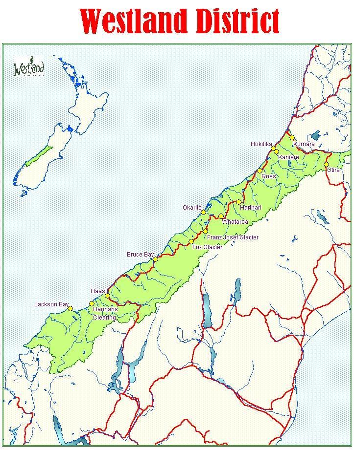
12 1.3 THE MANAGEMENT ENVIRONMENT Location Westland District is located on the West Coast of the South Island of New Zealand. The District includes the former Hokitika Borough and Westland County. The geographical extent of the District is shown in Figure 3. The land area of Westland District comprises approximately 11,400 km 2 (1,140,000 hectares). The District stretches for 330 kilometres from the Taramakau River in the north to Big Bay in the south. The western boundary is mean high water springs (MHWS) on the Tasman Coast and the eastern limit is a line running along the Main Divide of the Southern Alps/Ka Tirititi o te Moana. The District has common boundaries with Grey, Selwyn, Hurunui, Ashburton, Mackenzie, Waitaki, Queenstown-Lakes and Southland Districts and comes within the jurisdiction of the West Coast Regional Council Population and Settlement Westland was first settled by Europeans with the onset of the West Coast gold rushes in the 1860's. The District also has a long history of Maori settlement. Many important cultural sites remain, particularly along the coast and rivers, and reflect early patterns of resource use. Today tangata whenua in Westland is Ngai Tahu represented by three runanga Te Runanga O Tuhuru, Te Runanga O Te Koeti Turanga and Te Runaka O Kati Wae Wae. Hokitika was, and is, the largest settlement in the District. The town reached a peak population of more than 6,000 in 1866 at the height of the gold rush. Settlement spread south along the coast with activity centred on gold mining, forestry and farming. A wealth of historic places remain today in settlements and in areas which were worked. The population of the District stands at 10,025 (1996 Census) of which 3,342 live in Hokitika. Other significant settlements include Fox Glacier, Franz Josef Glacier/Waiau, Whataroa, Ross, Harihari and Kumara. The potential for growth associated with the tourist and mining industries cannot be overlooked. Any resultant increase in population will have a positive influence on community viability and associated services. Page - 11
13 1.3.3 Natural and Physical Resources and Activities Westland District is dominated by bush clad foothills and snow-capped mountains which are drained at regular intervals by large rivers. Closer to the coast these rivers have formed coastal plains. The forest areas of Westland represent a considerable resource and hold a number of significant values. Podocarp species have been utilised for their timber values since early settlement. The principal forest types are the hardwoods at the higher altitudes and mixed podocarps and hardwoods on the lower terraces. With some 85% of the land area in Westland being held under a conservation mandate by the Department of Conservation, little of this resource is available for production forestry. Timberlands West Coast Ltd manages both exotic and indigenous vegetation with exotic plantations occurring principally in the Waimea, Kaniere and Mahinapua forests with substantial plantings in the Ianthe and Wanganui Forests. Forested areas are also valued as wildlife and habitat areas, for soil conservation purposes and for recreation. A number of concessions, leases, easements and rights are held for land administered by the Department of Conservation for activities ranging from jetboating and canoeing, guided walks and climbs, gathering sphagnum moss, to mining and pastoral grazing rights. The high proportion of forested land in Westland and generally poor quality of the soils means that only relatively small areas of land are available for agricultural use. A strip of narrow, coastal soils and river flats have a medium to high value for food production. Over 173,000 hectares are farmed mostly on alluvial river flats. Dairying and beef farming dominate although sheep, deer and mixed livestock farming are also important. Mineral resources are plentiful in Westland. Gold, greenstone (pounamu), schist, aggregate and river protection rock are all found in quantities of economic significance. As at 2 nd October 1997, the following minerals permits and licences were issued in the District: 2 prospecting permits covering 267 ha. 53 mining licences covering 3, 549 ha. 2 prospecting permits covering 318 km exploration permits covering 2, 955 ha. 60 mining permits covering 2, 849 ha. These areas include areas of gold mining as well as greenstone and agricultural limestone. (source: Crown Minerals) Page - 12
14 Industries include sphagnum moss harvesting with processing plants having been established in the District. Other secondary processing industries include the dairy and meat factories, timber mills, and a fish processing plant. Physical resources include buildings and infrastructure. The transport network, in particular the State Highways, are vital to the communities in Westland due to the geographical nature of the District and its isolation from other parts of the country. Hokitika Airport, the Franz Josef Glacier/Waiau aerodrome, Waiho Flat Road airstrip, Mount Cook airstrip at Fox, as well as several Helicopter pads are important elements of the districts transport infrastructure which supports the tourist sector. Tourism has considerable potential to expand in Westland. The New Zealand Tourism Board is promoting a figure of 3 million visitors to New Zealand by the year Tourism is recognised as a key area of economic growth on the West Coast which is well placed to take advantage of any increases. The District's scenic, recreational and historic attractions mark it as a prime tourist destination. The creation of a World Heritage Area in the south of the District and the establishment of the West Coast Heritage Highway may prove to be significant additional attractions for Westland. Page - 13
15 Page - 14
16 PART 2 - IMPLEMENTATION AND PROCEDURE 2.1 THE COUNCIL'S FUNCTIONS AND RESPONSIBILITIES 2.2 DUTY TO COMPLY 2.3 APPLYING FOR A RESOURCE CONSENT Types of Consent Existing Uses Information to be Supplied Notification Notification Procedure Submissions Hearings Exemptions to the Plan Fees 2.4 DESIGNATIONS AND HERITAGE ORDERS Designations State Highway Designations Heritage Orders 2.5 PLAN CHANGES AND THE DISTRICT PLAN REVIEW Changes to the District Plan Review of the District Plan Interim Provisions 2.6 ISSUES CROSSING TERRITORIAL BOUNDARIES Issues straddling district boundaries Issues with District and Regional interest Page - 15
17 PART 2 - IMPLEMENTATION AND PROCEDURE 2.1 THE COUNCIL'S FUNCTIONS AND RESPONSIBILITIES The Council must implement the Plan in accordance with the provisions of the Resource Management Act The Act requires the Council to prepare a District Plan for the purposes of carrying out its functions in order to achieve the purpose of the Act. The purpose of the Act is "...to promote the sustainable management of natural and physical resources." (Section 5 (1)). The Act defines sustainable management as: "... managing the use, development, and protection of natural and physical resources in a way, or at a rate, which enables people and communities to provide for their social, economic, and cultural well-being and for their health and safety while- (a) (b) (c) Sustaining the potential of natural and physical resources (excluding minerals) to meet the reasonably foreseeable needs of future generations; and Safeguarding the life-supporting capacity of air, water, soil, and ecosystems; and Avoiding, remedying, or mitigating any adverse effects of activities on the environment." Sections 6, 7 and 8 of the Act set out principles for the sustainable management of natural and physical resources that guide the Council. Section 6 states "Matters of National Importance" as follows: "In achieving the purpose of the Act, all persons exercising functions and powers under it, in relation to managing the use, development, and protection of natural and physical resources, shall recognise and provide for the following matters of national importance: (a) (b) The preservation of the natural character of the coastal environment (including the coastal marine area), wetlands, and lakes and rivers and their margins, and the protection of them from inappropriate subdivision, use and development: The protection of outstanding natural features and landscapes from inappropriate subdivision, use, and development: Page - 16
18 (c) (d) (e) The protection of areas of significant indigenous vegetation and significant habitats of indigenous fauna: The maintenance and enhancement of public access to and along the coastal marine area, lakes and rivers: The relationship of Maori and their culture and traditions with their ancestral lands, water, sites, waahi tapu, and other taonga. Section 7 Lists "Other Matters" as follows: "In achieving the purpose of this Act, all persons exercising functions and powers under it, in relation to managing the use, development, and protection of natural and physical resources, shall have particular regard to- (a) (b) (c) (d) (e) (f) (g) (h) Kaitiakitanga: The efficient use and development of natural and physical resources: The maintenance and enhancement of amenity values: Intrinsic values of ecosystems: Recognition and protection of the heritage values of sites, buildings, places, or areas: Maintenance and enhancement of the quality of the environment: Any finite characteristics of natural and physical resources: The protection of the habitat of trout and salmon." and Section 8 relates to the Treaty of Waitangi. "-In achieving the purpose of this Act, all persons exercising functions and powers under it, in relation to managing the use, development, and protection of natural and physical resources, shall take into account the principles of the Treaty of Waitangi (Te Tiriti o Waitangi)." The specific functions, powers and obligations of the District Council include responsibility for developing and implementing objectives, policies and methods to achieve integrated management of effects of land based activities; the control of the effects of land use including implementing rules for natural hazards and hazardous substances management, controlling land subdivision and noise emissions and control of the effects of activities on the surface of lakes and rivers. Page - 17
19 In working towards the achievement of the purpose of the Act, the Council will seek to ensure that in the short and long term adverse environmental effects are avoided, remedied or mitigated. In the context of Westland District, implementation of such a philosophy through the District Plan requires recognition of and management of conflicts in order to promote sustainable management. An example of such a situation is divergence of views on mining activities, particularly when they are located in natural environments. In the short term the effects of such an activity may constitute a nuisance, in the long term the effects may be minimal, in particular where rehabilitation is successful. The Council is committed to taking account of the views of all parties and interests in ensuring that the future viability of the Westland environment including communities is not jeopardised. Page - 18
20 2.2 DUTY TO COMPLY The Resource Management Act 1991 is a complex piece of legislation which repealed over 20 Acts of Parliament. The Council is required to enforce compliance with the Act through the provisions of the District Plan. Accordingly before commencing any activity relating to the areas Council has functions and powers over, the Plan should be checked for compliance of that activity. Should compliance not be possible then an application for a resource consent may be required (See Section 2.3). In addition to the requirements of the Plan every person has a duty to avoid, remedy or mitigate any adverse effects on the environment whether or not the activity concerned is in accordance with a rule in the District Plan, a resource consent or relates to a use carried out before the Act came into force. (Section 17 (1) of the Act). Although this duty in itself cannot be enforced, the enforcement provisions contained in the Act do give the Council legal power to act in these situations. The Building Act 1991 should also be considered by those wishing to carry out an activity on land. The Building Act establishes a framework for the control, construction and maintenance of buildings to safeguard public health, safety and amenity. While a consent may not be required under the Building Act, the District Plan may require that a consent be obtained under the Resource Management Act. Page - 19
21 2.3 APPLYING FOR A RESOURCE CONSENT Types of Consent There are two types of resource consents which the District Council may require for an activity which does not comply with a provision of the District Plan, namely:- (a) (b) a land use consent, and a subdivision consent Additional consents may be required by the Regional Council for activities involving the taking of water, the use of coastal resources, disturbance of the land surface and earthworks, or discharges into air, water or onto land. The West Coast Regional Council should be contacted for information regarding these types of consents and compliance with regional plans. The Act requires that information accompanying each application be sufficient to enable it to be readily understood. The type of information and the level of detail required will depend on the category of activity for which the application is made and the scale and magnitude of environmental effects which the activity may generate. Activities requiring a resource consent will be determined by standards and criteria laid out in the Plan. There are four categories of consent provided for in the Plan. These are: (i) (ii) (iii) (iv) Permitted Controlled Discretionary Non-complying Permitted activities do not require a consent provided full compliance can be demonstrated with all rules in the Plan. On application the Council may issue a Certificate of Compliance for the activity. Resource consents can be obtained for controlled and discretionary activities in accordance with rules and criteria specified in the Plan. Applications for controlled activities must be granted by Council but can be subject to conditions on matters specified. Activities which contravene rules in the Plan or that do not meet discretionary criteria can apply for resource consent as a non-complying activity. Page - 20
22 2.3.2 Existing Uses Activities requiring resource consents under the Plan should be checked for existing use rights. (Section 10 of the Act). Under this provision certain existing uses of land which would normally require a resource consent are permitted to continue Information to be Supplied The information to be supplied with an application for a land use or subdivision consent shall be to the extent specified on the prescribed form available from Council offices. In accordance with section 92 of the Act, the Council can also require that further information be supplied by the applicant after receipt of the application. The Council may, where it considers it appropriate, commission a report on any matters relating to the application or on the information supplied on the application by the applicant Notification The matter of whether a resource consent application will be notified will be determined in accordance with the provisions of Sections 93, 94 and 95 of the Act, notwithstanding any other provision of the Plan. Subject to the provisions of the Act, an application for a resource consent is not required to be notified in accordance with Section 93 of the Act, if: i) The application is for a subdivision consent which is a controlled activity. ii) iii) The application relates to a controlled activity, or a discretionary activity over which the Council has restricted the exercise of its discretion, and the Plan expressly permits consideration of the application without the need to obtain the written approval of affected persons. The application relates to a controlled activity and written approval has been obtained from every person who in the opinion of the Council may be adversely affected by the granting of the resource consent; unless in the Council's opinion it is unreasonable, in the circumstances, to require the obtaining of every such approval. Page - 21
23 iv) The application relates to a discretionary activity or noncomplying activity and the Council is satisfied that the adverse effect on the environment of the activity of which consent is sought will be minor; and v) Written approval has been obtained from every person whom the Council is satisfied may be adversely affected by the granting of the resource consent, unless the Council considers it is unreasonable in the circumstances to require the obtaining of every such approval. Notwithstanding i) to v) above, the Council may require any application to be notified even if this Plan expressly provides that it need not be notified, if the Council considers special circumstances exist in relation to the application Notification Procedure The notification process is carried out in accordance with the requirements of Section 93 of the Act. This procedure involves preparing a notice in the forms set out in the Resource Management (Forms) Regulations 1991 (Form 6) and serving copies of it on the following people: Owners and occupiers of the site. Persons likely to be directly affected, including adjacent owners and occupiers of land. Local authority, iwi authorities and others as the Council considers appropriate. This category may include Heritage Protection Authorities, Ministers of the Crown, interest groups and community organisations. A list is held by Council for the purpose of notification. This notice is also required to be fixed in a conspicuous place on the subject site and to be published in the newspaper. The notice will give details of the application and give the closing date for submissions to be received by the Council. Submissions must be in writing and may be made by any person. They should be sent to the Council Office nominated in the notice and served on the applicant. Page - 22
24 2.3.6 Submissions Submissions on a resource consent application that is notified may be made by any person or body. The information required in a submission should include: the reasons for making the submission the decision the person making the submission wishes the Council to make whether or not the person making the submission wishes to be heard by the Council Hearings A hearing will be held by the Council to consider the application for a resource consent unless there are no submissions or the parties involved do not wish to be heard. The Act provides for pre-hearing meetings to be held for the purposes of clarifying, mediating, or facilitating the resolution of any issues raised by submitters. On completion of the hearing the Council makes its decision on the application which is circulated to the applicant and submitters. A right of appeal to the Planning Tribunal exists for all parties involved Exemptions to the Plan Fees If the limited exemption available under section 4(3) of the Resource Management Act 1991 is to be invoked by the Crown, the Council shall be notified of this intention and the nature of the work or activity. The notification should state the consistency of the proposed exemption with the relevant strategy or management plan and an assessment of its impact on adjoining land and resources so Council can check its consistency with section 4(3) of the Act. The Council shall from time to time set any fees or schedule of fees, that it considers necessary in order to recover the reasonable costs of processing resource consent applications. The schedule will be available from Council offices. In addition the Council may charge resource consent holders for any monitoring of conditions on a resource consent as it deems appropriate. Page - 23
25 2.4 DESIGNATIONS AND HERITAGE ORDERS Designations Designations are provisions made in the District Plan for public works or for projects or works of requiring authorities. A requiring authority is a Minister of the Crown, a local authority or an approved network utility operator and includes Westland District Council. The requiring authority must serve a notice of requirement on the Council with the appropriate information. The Council will consider the proposal and make a recommendation to the Minister or network utility operator. The Council will consider the environmental effects of the proposal, including effects on historic places. Once confirmed, the Council must identify the land to be designated and state the purpose for which the land is to be used without further formality. Designated lands are identified on the Planning Maps and Appendix B. Where a designation is included in the District Plan, then, notwithstanding anything contrary in the Plan and regardless of any resource consent (but subject to Sections 9(3) and 11 to 15 of the Act): (a) (b) The requiring authority responsible for the designation may do anything that is in accordance with the designation and No person may, without the prior written consent of that requiring authority, do anything in relation to the land that is the subject of the designation that would prevent or hinder the work State Highway Designations The "State Highway Purposes" designation provides for Transit NZ, either itself or through agents, to control, manage and improve the state highway network. Two sections of State Highway 6 have been declared "Limited Access Roads" under the Transit NZ Act The two sections are Taramakau River to Richards Drive, Hokitika, and Weld St Hokitika to Ruatapu. The objective of this control is to protect and maintain the safety and high level of traffic service on these important routes which may otherwise be adversely affected by subdivision and traffic generating activities. The effect is to prevent the proliferation of new access points and to reduce the number of accesses and volumes of traffic using them. State Highway 6 runs through Mount Aspiring National Park and Westland National Park/Tai Poutini National Park, and State Highway 73 through Arthurs Pass National Park. The existing state highways are not part of the national park. As such they are designated in the Westland District Plan as part of the existing state highway network. Page - 24
26 If a proposed work encroaches onto national park land, the appropriate statutory approval for land use is via a Section 55 application under the National Parks Act The Minister of Conservation may, in accordance with the management plan policies for the national park in question, grant approval for the construction of roads over or through the park. Where required, appropriate resource consents must also be applied. In Westland District, one Section 55 consent has been granted for proposed works associated with the Otira viaduct and its approaches. The consent gives statutory approval for the design and construction to proceed subject to conditions Heritage Orders Heritage orders have the effect of protecting places or areas of special interest, character, intrinsic or amenity value or visual appeal, or of significance to tangata whenua. The use of land in the area subject to the order may be restricted in a manner that ensures the effect of the heritage order is not wholly or partly nullified. Land which is the subject of heritage orders in Westland District will be identified in the Plan. Page - 25
27 2.5 PLAN CHANGES AND DISTRICT PLAN REVIEW Changes to the District Plan Any person (in addition to the Council) can make a request to change the District Plan in accordance with the provisions of the 1st schedule, Part II of the Act. The Council will consider whether to proceed with the plan change request and can either adopt it in whole or in part as its own change, or process the application as a private request. The Council may charge applicants for the costs of change to the District Plan or for the carrying out of its functions in relation to such applications Review of the District Plan The Act requires that a full review of the Plan be commenced within 10 years of it becoming operative. The review of the District Plan will generally take into account the information collected under the District's environmental monitoring programme including the monitoring of the effectiveness of objectives, policies, and rules in the Plan, and monitoring of the effectiveness of, and compliance with, conditions set out on resource consents. If changes to the Plan are deemed necessary as a result of any review, they shall be carried out in the manner set out in the First Schedule to the Act Interim Provisions The Council has sought a range of interim provisions while it prepares a Significant Natural Areas (SNA) Survey. These recognise the importance of ecosystems, natural habitats and landscapes within the Westland District in regard to Section 6 (and Part II matters) of the Resource Management Act. It is the intention of Council that the District Plan provide a scheduled approach to protect all SNA. However, at the present time the Council has insufficient information upon which to identify them. Accordingly, the objectives, policies and rules relating to the clearance of indigenous vegetation will be reviewed subsequent to the completion of the SNA survey. (Refer to Part 4.9: Method e. ) Page - 26
28 2.6 ISSUES CROSSING TERRITORIAL BOUNDARIES Issues straddling district boundaries The characteristics of natural and physical resources are such that the management issues which relate to them may not necessarily be confined to one district. However the Council envisages that there will be very few issues which fall into this category within Westland District with the possible exception of the proposed Haast Hollyford Road. In this and any other possible future cases, appropriate consultation procedures will be set in place and the option of joint hearings involving the affected District Councils will be considered. Other than the above, specific provision for addressing such issues is not provided for in the Plan Issues with District and Regional interest It is likely that some issues will be of concern to both the District Council and the Regional Council and that some functions may overlap. In the situations where resource consents are required from both authorities, liaison will take place and where issues are best resolved in one forum, joint hearings will be held. No transference of functions has been proposed between the Regional Council and the Westland District Council and therefore the Councils will be guided as to their functions by the Act. Page - 27
29 PART 3 - KEY RESOURCE MANAGEMENT ISSUES AND OBJECTIVES 3.1 EXPLANATION 3.2 SUSTAINABLE COMMUNITIES 3.3 IMAGE OF THE DISTRICT 3.4 INFRASTRUCTURE AND SERVICES 3.5 MAORI PERSPECTIVE 3.6 MINERAL RESOURCES 3.7 NATURAL ENVIRONMENTS 3.8 THE LAND RESOURCE 3.9 THE BUILT RESOURCE 3.10 LANDSCAPE 3.11 WATER RESOURCES 3.12 THE COASTAL ENVIRONMENT 3.13 NATURAL HAZARDS. Page - 28
30 PART 3 - KEY RESOURCE MANAGEMENT ISSUES AND OBJECTIVES 3.1 EXPLANATION This part of the Plan sets out a framework under which the "Vision for Westland" can be achieved in tandem with on-going development and implementation of the Councils own corporate planning and those of other agencies. Key resource management issues are clearly identified, discussed and evaluated. Issues arise when the demands or expectations placed on resources differ between different groups in society, or when there are major environmental effects arising from any one activity. Successful resource management, as guided by the principle of sustainable management, is one method of resolving such conflicts or avoiding, remedying or mitigating adverse environmental effects. The objectives contained in this part of the Plan specifically address and flow from key resource management issues for Westland. Each objective provides the basis for policy development in Part 4 of the Plan. Accordingly the structure of each section of this part of the Plan takes the following form: Key Issue The key or significant resource management issue relevant to Westland is stated. Background The background to the issue is explained which identifies the resources and affected resource users. Objective Objectives reflect specific environmental outcomes desired by the District that relate directly to each issue. Objectives should be achievable and where possible measurable. Reasons The principal reasons for adopting each objective are stated. They explain how each objective is necessary to promote sustainable management and to fulfil the Council's functions and responsibilities under the Act. Page - 29
31 3.2 SUSTAINABLE COMMUNITIES Key Issue The need to encourage community well being and viability in a manner that which will ensure the sustainable management of Westlands natural and physical resources. Background Westland is well endowed with natural and physical resources on which the viability of Westland's communities depend, both directly and indirectly. Reliance on the resource base has been a feature of Westland's population for more than 100 years. As in other parts of New Zealand, the number of people living in the District has fluctuated as different resources are utilised. Population numbers peaked in the 1860's during the goldrush and now Westland District supports just over 9,200 people, of which approximately 40% live in Hokitika. Loss of population can severely limit the viability of a range of services and has a negative impact on the economic and social structure, and the health of what in Westland are predominantly small, tight-knit and often isolated communities. The Council has given priority to the issue of community viability and recognises people as a most important asset to Westland District. The Council is very aware that sustainability of the natural and physical resource base is fundamental to, and is interconnected with, the continued welfare of the District's communities. For example, a safe and efficient state highway network is essential to enable people to move themselves and goods. Development should therefore not occur where it will mean that "bottom lines" are threatened, that is, that there will be a level of resource use or degradation at which severe or irreversible damage occurs. Above this, the Council will be guided by a number of performance standards designed to avoid, remedy or mitigate adverse effects. Page - 30
32 Objective To establish levels of environmental quality for Westland which enable people and communities to provide for their social, economic and cultural well being, while meeting the principles of sustainable management of natural and physical resources. Reasons Will allow clear provision to be made for establishing the level of environmental quality desirable in Westland. Recognises the principle of sustainable management and also the importance of people and communities in Westland. Will provide people and communities with the necessary power and freedom to use, develop and protect natural and physical resources as they see fit within a framework set by environmental "bottom-lines" and performance standards. Page - 31
33 3.3 IMAGE OF THE DISTRICT Key Issue Threats to Westland's environment as a result of insensitive developments and activities. Background Westland is internationally renowned for its outstanding natural landscapes and pristine water environments. This clean, green image is one which the Council wishes to promote as it provides the community with a sense of identity and pride and leads to financial benefits from tourism. In order to ensure that Westland remains widely recognised as clean and green, the Council will seek to ensure that the effects of activities which directly threaten this image are avoided, or where this is not practicable, that such activities are mitigated. For example, the Council (in conjunction with the Regional Council) will seek to control hazardous waste or developments which could contaminate land. The Council realises that international issues such as depletion of the ozone layer, global warming and rising sea levels may have an impact on Westland. The Council is supportive of efforts to research the effects these may have. The Council also expresses its support for the terms of the New Zealand Nuclear Free Zone, Disarmament and Arms Control Act 1987 and will not support the introduction of nuclear energy, the manufacture and production of radioactive material, nor the disposal of waste products resulting from the use of radioactive materials. The Council wishes to encourage local efforts to enhance the clean, green image of Westland. Initiatives to reduce, reuse or recycle waste for example will be supported. Reduction and reuse are most effective as they avoid having to deal with unnecessary waste. Provision of recycling facilities at major refuse sites will be supported where the material is self-sorted and can be put to good use. The Council would also like to see energy saving measures such as energy efficient design and insulation but believes that the costs of rules on this basis outweigh the benefits and thus relies on individual action. Page - 32
34 Objective To recognise and promote Westland's image as a clean, green District. Reasons Recognises the value of Westland's character for the well-being of the community and as a tourism asset. Aids in sustaining natural and physical resources. Page - 33
35 3.4 INFRASTRUCTURE AND SERVICES Key Issues Adverse environmental effects of the development of infrastructure and services. Threats to the infrastructure resource as a result of developments which may adversely affect their operation. Background Infrastructure and servicing facilities are an important part of the physical resource base. Water supply, stormwater and sewerage systems, rubbish disposal, roading, rail and air travel facilities are vital to the development of Westland but care needs to be taken to ensure that they do not generate adverse effects on amenities and resources. For example leachate contamination of water and soil from rubbish disposal sites can have significant environmental effects. Facilities which service the community such as reserves and recreation facilities are also important to the well-being of the community. The effective and efficient provision of services in Westland is hampered to some degree by the low population, small size and geographic isolation of settlements. Isolation highlights the importance of the transport network, in particular the state highway system; air transport; and the need for adequate telecommunications systems, radio and television transmission. For example, the Hokitika airport is important to the current and future business and tourism development in the District. The level of services, and the cost to extend, upgrade or add new facilities can act as an effective constraint on further development. The level of isolation experienced in many parts of the District emphasises the need for Westland to become less energy dependent on the rest of New Zealand and more energy efficient. In this regard, hydro electric power generation could represent a viable option in the future provision of the District's energy needs. In addition, independent and small scale generators of energy are likely to be required. Where the environmental impacts of infrastructure development may be significant, well managed siting, design and construction of facilities will have to avoid or mitigate adverse impacts. Once the infrastructure is in place adverse effects on them should be minimised in order to protect the resource. For example, access points onto a State Highway should be carefully managed to protect the value of the State Highway for efficient traffic movement. Signs and activities with the potential to cause distraction to traffic also need to be controlled. Infrastructure, service and communications resources represent a significant financial investment and are highly valued by the community, business and industry. Page - 34
36 Recreational facilities are important elements of the District's infrastructure. The District is well endowed with passive outdoor spaces and much more active recreation occurs on land managed by Timberlands West Coast and the Department of Conservation. Indoor facilities, however, are especially desired, given high rainfall in the District. Without the Council being involved in the provision or significant enhancement of recreational facilities, it is possible that a number of recreational options would be unavailable due to the low population. Objectives To ensure that all servicing activities are carried out in a manner, and in locations, which avoid, remedy or mitigate adverse environmental effects To ensure that activities located adjacent to infrastructure resources do not adversely affect the safe and efficient use of those resources To ensure that new development provides for a share of the requirements for recreation facilities generated in the District. Reasons Ensures that Council activities and those of other organisations involved in service and infrastructure provision are treated equally and according to common criteria. Infrastructure and services make a significant contribution to the welfare of people and communities but can also impact on their welfare and amenities if effects are not managed effectively. Infrastructure resources and service facilities are significant physical resources which represent a substantial financial and social commitment. As such the effects of activities which may detrimentally impact on this resource need to be effectively controlled. New and upgraded recreation facilities are in constant demand from residents especially as a result of new development in the District. Page - 35
37 3.5 MAORI PERSPECTIVE Key Issue The ability of tangata whenua to exercise their traditional relationship with ancestral lands, water, sites, waahi tapu and other taonga is sometimes threatened by conflicting values on activities. Background Westland has a long history of Maori occupation and, as a result of this, there are many important archaeological sites in the District. The main focus of settlement in Westland was believed to be in the Hokitika area where pounamu was abundant. Access to the District was generally from walking along the seabeach, or through river valley and mountain pass routes because canoe voyaging was a dangerous undertaking on the hazardous Tasman sea. Most early Maori communities lived in the coastal fringes around river mouths and sheltered bays. Archaeological sites indicate that Maori utilised the pounamu of the District and lived off fish and forest birds. The natural environment held great importance for the Maori, a factor which remains relevant today. The Resource Management Act specifically requires all persons exercising powers and functions under the Act to have regard to kaitiakitanga - or the traditional Maori way of protecting the value of the land, and passing it to future generations in a state which is as good as, or better than, the current state. In achieving the purpose of the Act, the principles of the Treaty of Waitangi shall also be taken into account. The Council recognises the mana whenua and rangatiratanga of Poutini Ngai Tahu in Westland and will consult with the hapu and individuals generally on all major issues of land and water use and especially in those areas that have been identified to Council as being of particular significance to Poutini Ngai Tahu. Where waahi tapu are identified by Ngai Tahu, the Council will use whatever non-statutory means appropriate to promote their protection. The Council also recognises the special relationship of Poutini Ngai Tahu with the total environment and their particular concerns. For example, effluent and waste disposal are of particular concern especially where effluent enters rivers and coastal waters. The special needs of Poutini Ngai Tahu will also be recognised, for example in relation to providing for marae (meeting places) and papakainga (traditional community housing). Page - 36
38 Objectives To pursue a partnership of consultation and participation between the Council and Poutini Ngai Tahu relating to resource management To recognise and provide for the relationship, culture and traditions of tangata whenua with their ancestral lands, water, sites, waahi tapu and other taonga. Reasons Recognises and provides for Sections 6(e), 7(a) and 8 of the Resource Management Act. Page - 37
39 3.6 MINERAL RESOURCES Key Issue Mineral extraction and exploration activities can adversely affect the natural landscape and ecosystems, amenity value, and water quality. Background Westland has from pre-european times traditionally been the site of mineral exploration and development. Gold, Pounamu (Greenstone), mineral sands, decorative stone, aggregate and river protection rock have either been mined or have potential for development within the District. The aggregate resources and river protection rock in Westland are rich and resources are expected to last for a considerable period of time. Gold mining has also experienced a resurgence in recent years although nothing on a scale to resemble the initial gold rushes of the 1860's throughout the District. Access to mineral resources and mining are controlled by a number of bodies. Under the Crown Minerals Act 1991, permits are issued for prospecting, exploration and mining rights of Crown minerals. Certain types of land require landowner consent to carry out even minimum impact activities. These classes of land include: land managed under the Conservation Act; land subject to QEII open space covenant; land under crop; land of 4.05 hectares or less; and land regarded as waahi tapu. For all activities, other than minimum impact activities (as defined in the Crown Minerals Act) the landowner has a right of veto to non-petroleum minerals unless the compulsory arbitration provisions are invoked. The Department of Conservation has a statutory responsibility to develop management policies and strategies for land the Department manages. These polices and strategies can provide for the appropriate utilisation of mineral resources on land managed by the Department, while at the same time protecting that land from the adverse effects some mining activities could have. At the Regional Council level, a resource consent application will be required to deal with matters such as soil conservation, discharges to air and discharges to water. Westland District Council recognises the utilisation of mineral resources as important for the communities viability and that the use can have adverse effects that need to be avoided, remedied or mitigated. Such effects may include impact on roading, or the need to restore landscapes. Page - 38
40 Objective To enable people and communities to provide for their economic and social wellbeing through the efficient utilisation and development of mineral resources To safeguard the life supporting capacity of air, water, solid and ecosystems and avoid, remedy or mitigate adverse effects from the use and development of mineral resources To avoid, remedy or mitigate mining s adverse effects on natural environments, landscapes and waterways. Reasons Encourages efficient utilisation of mineral resources for the benefit of communities in Westland. Allows balancing of short term effects against long term benefits and provides protection for ecosystems, natural and physical resources. Recognises responsibility of the District Council in conjunction with other responsible agencies. Page - 39
41 3.7 NATURAL ENVIRONMENTS Key Issue Utilisation of natural areas (including habitats) may in some instances threaten the health and integrity of the resource. Background Westland is recognised both nationally and internationally as having outstanding and relatively unmodified natural areas. Such areas include what is commonly referred to as the last great Kahikatea forest at Hunts Beach and habitats for rare flora and fauna. The internationally recognised South West New Zealand World Heritage Area is, for a large part, contained within the District, as are Westland, Arthurs and Mount Aspiring National Parks, numerous wilderness areas and protected areas. Consequently some 85% of the District's land area is managed under a conservation mandate covering the vast majority of lands with significant conservation values. These conservation areas have varying degrees or levels of protection and are largely administered and managed by the Department of Conservation. It is envisaged that the West Coast Conservation Management Strategy will provide additional guidance and control on activities on this land. Given the over-riding emphasis on conservation orientated-management within the District, the Plan's approach is to support sustainability managed, development opportunities that can avoid, remedy or mitigate adverse effects on the natural environment. The Council also has an active policy of encouraging land swaps, whereby land with conservation values, outside the DOC estate, is exchanged for land within the DOC estate which does not have significant conservation values (for example, some stewardship land). The adverse effects of activities need to be controlled so that the integrity of natural areas is retained. The pressure for urban or farming activities is limited due to the remoteness of most such areas and the Conservation mandate. But activities which have the potential to impact on the natural values of such areas include mining, harvesting activities (for example sphagnum moss) and tourism. Many tourist activities rely on the 'untouched and unspoilt' nature of natural areas, whereas mining can have quite a significant adverse effect depending on the scale, location and duration of the activity. While tourism can generate employment and growth, it can also lead to pressure on resources. Development may occur in inappropriate locations, so generating adverse environmental effects compromising the very values that first attracted visitors. Page - 40
42 Objective To recognise and provide for the unique values and importance of natural environments and ecosystems in Westland To recognise that the people of the district can provide for their needs within the context of sustainable management To protect the integrity, functioning, and health of indigenous ecosystems and maintain the current diversity of indigenous flora and fauna. Reasons Gives explicit consideration of Section 5 of the Act, in particular "safe-guarding the life supporting capacity of air, water, soil and ecosystems..." and its importance in achieving sustainable management of resources. Gives regard to Section 6(c) of the Act, protection of areas of significant indigenous vegetation habitats and fauna and Section 7(d), intrinsic values of ecosystems. Recognises the multi-value nature of natural environments in Westland, their national and international significance and the need for clear management guidance. Page - 41
43 3.8 THE LAND RESOURCE Key Issues Land use activities can adversely affect the quality, versatility or retention of topsoil, the natural landscape and ecosystems and amenity values. Background The productive land resource in Westland is finite and limited by the dominance of steep bush and mountainous areas. Consequently most fertile soils are restricted to strips along the main rivers, smaller streams or on alluvial fans. The richest soils in Westland are the Hokitika soils and have formed on recent alluvium deposited by rivers (including the Hokitika, Kokatahi and Waitaha Rivers). Ikamatua soils are also among the most fertile but have an extremely limited distribution. Small pockets are found on the north bank of the Arahura River and in the vicinity of Kokatahi and Kowhitirangi. Other soils with good pastoral potential include Harihari soils located along Taramakau, Arahura, Kaniere and Kokatahi Rivers and in substantial stretches in the Harihari/Whataroa locality. However drainage of Harihari soils is required before agricultural use. Other soils suitable with medium value for farming purposes include the Mahinapua soils. These soils occur in a narrow coastal strip from the Taramakau River in the north to the Mikonui and Waitaha Rivers in the south. The dominant agricultural activities in Westland are dairying (especially in the north of the District) and beef farming (most common in south Westland). Some of New Zealand's richest and most productive farms are found within the District. Other types of productive land use include sheep, deer and mixed livestock farming and forestry. Westland District is not a significant pig farming area with only nine farms recorded as containing pigs in Land which is not in agricultural use in Westland is dominated by forest or including regenerating indigenous vegetation, and is often located on steeper sloping hillsides. Soil quality is low, ranging from Class IV to Class VIII land. (New Zealand Land Resources Inventory). However much of this land has important erosion control value. Where activities have an effect on soil conservation, the Regional Council is responsible for their control. The 1986 West Coast Accord, a contract between the Crown, West Coast local government, national conservation interests and the West Coast timber industry provides for the maintenance of the sawmilling industry on the West Coast and a transition from non-sustainable management of Crown forests to sustained yield management of Crown production forests. Page - 42
44 The productive land resource in Westland is generally managed with a commitment to the sustainability of the soil. However external and internal factors, particularly the general decline in farm incomes can pressure the land resource and lead to overuse or its conversion so that it is no longer available for primary production. Diversification of the rural economy is generally desirable but it should not prejudice protection of the overall productive potential of the soil resource and maintenance of the unique lifestyle opportunities available within the District. In some instances the economic viability of a farm will depend on access to Crown lease-hold land. The security of tenure of these leases is of particular concern to the rural community. It is essential that the options available to rural communities to remain viable are kept open or not unduly restricted. This includes the ability to enhance the productive use of land for example through moss harvesting. Demand for rural-residential subdivision development close to settlements is an example of possible pressure on the productive land resource. However, demand is not great for such development so undue constraint is not considered necessary given the benefit of attracting people to the District. The outer edges of settlements are however, defined to avoid unnecessary expansion onto rural land and ribbon development. Subdivision in the rural area down to 5000m 2 minimum lot sizes, controls residential development with regard to access and suitable lot sizes in accordance with market demand. This approach has the positive effect of conserving more land for primary production, by not forcing larger than desired rural residential lots. Where land adjoining a waterbody is subdivided, some land may be required to be set aside for an esplanade reserve, esplanade strip or access strip. Westland District contains many kilometres of land adjoining waterbodies. As the pressure for subdivision is low it is unlikely that a connected system of esplanade reserves will develop. The Council therefore considers that applications to waive or reduce requirements may be acceptable provided that there are no outstanding conservation, recreation or access values. Objectives To avoid, remedy or mitigate adverse effects of land use activities on land and water resources To protect and maintain the productive potential of the higher quality soils in Westland District. Page - 43
45 Reasons Recognises the contribution that utilisation of the productive land resource makes, and will continue to make, to the character of Westland. Allows control of effects which might have a direct impact on sustainability of the productive land resource and the wider ecosystem including environmental amenities. Recognises the finite nature of the productive land resource, and the potentially conflicting uses of the resource. Page - 44
46 3.9 THE BUILT RESOURCE Key Issues Threats to the distinctive character of Westland settlements including adverse environmental effects arising from the design, siting or construction of buildings, including the siting of new subdivisions. Adverse effects of activities in urban areas on residential amenities and environmental quality. Background Westland's settlement pattern (with the major exception of Hokitika) is characterised by small, isolated communities generally centred on farming, and more recently on tourism. Hokitika has a population of over 3,200 people and is the largest settlement in Westland. It provides services and important facilities for much of the District. The buildings within Hokitika and other settlements therefore represent an important resource for the community. Infrastructure elements, including the State Highway network, are also a key element in the built environment and are discussed separately in section 3.4. The built environment is generally to be managed in such a way that character is enhanced and tourist opportunities are maximised. Hokitika should become a tourist and visitor destination in its own right, rather than a convenient stopping place for attractions further north or south. Hokitika's greater size and the potential for relatively large scale activities to locate in the town, such as hotels and other tourist facilities, means that segregation of activities on the basis of effects might be more appropriate here than in the District's smaller settlements. Future growth in Hokitika will be dependent on new industry and business locating in the town and the expansion of existing enterprises. The siting of new subdivision and the extent of town boundaries must be considered as part of the expansion and development of Hokitika as a whole. Recent subdivision in Hokitika has to date been concentrated in a few areas, such as Blue Spur. The smaller settlements in Westland perform important rural and tourist servicing roles and can be grouped on the basis of character and function. For example predominantly tourist settlements include Fox Glacier, Franz Josef Glacier/Waiau, and Haast; the coastal settlements include Okarito, Okuru, Neils Beach, Jackson Bay/Okahu and Bruce Bay, and the small settlements such as Arahura, Kumara, Whataroa, Hannah's Clearing and Harihari have largely rural service functions. A number of settlements, for example Woodstock and Rimu are not recognised by the existing zoning pattern. Woodstock and Rimu are both close to Hokitika, were originally gold mining settlements and are rich in heritage and character. Page - 45
47 Planning must take into account and enhance where necessary, the historic values of heritage buildings and sites in Westland. The historic resource has significant tourist appeal and historic resources also make an important contribution to the character of individual settlements. The District Council is responsible for the integrated management of the effects of land use activities. Accordingly, the Council must set criteria which determine under what circumstances industry and commerce, residential, rural and recreation activities and public services and infrastructure establish and operate. Expressed as standards, performance levels ensure that environmental quality is maintained and enhanced, wherever an activity locates. Where activities meet performance standards they are permitted. Where one or more performance standards cannot be met, an application is required. Although an application may be required, an activity can be suitable if it conforms to general policies - for example a school or a church is likely to be acceptable in a residential area. Objectives To identify, protect and enhance the distinctive Westland character of the District s settlements To provide for the intermingling of land use activities within Westland s settlements and towns, where this does not detrimentally impact on the amenities, health and safety of residents and workers. Reasons Encourages improvement in the visual appeal and amenities of settlements and recognises the importance of settlements as a tourist and visitor attraction. Ensures that a range of lifestyle and living opportunities continue to be available in Westland. The built environment is a significant resource the quality of which is essential to the continued welfare of people and the character of the District. Page - 46
48 Recognises that sustainable management of natural and physical resources also includes management of structures and buildings including protection of them from adverse effects. Segregation of activities can only be justified for the purposes of avoiding, remedying or mitigating adverse environmental effects. Rules for the avoidance and mitigation of natural hazards must be incorporated into the District Plan. Several hazards pose a significant threat to the built resource of the District and to people and communities. Page - 47
49 3.10 LANDSCAPE Key Issue Adverse effects of a variety of activities on the integrity of the existing landscape and character of Westland. Background The Westland landscape is comprised of a distinctive mix of natural features, including the mountains and peaks of the Southern Alps/Ka Tiritiri o te Moana, glaciers, lakes and rivers, extensive areas of relatively unmodified indigenous vegetation, the coastline, and a unique flora and fauna. The built environment and pastoral farmland are also significant in some areas. Westland is the unbroken ecological sequences that exist between the mountains and the coast over a distance of generally less than 50 km. The integrity of this landscape, particularly in the south of the District, is significant. The northern part of the District is more heavily populated relative to south Westland and contains comparatively larger tracts of private land used for traditional rural activities, for example in the Kokatahi, Whataroa and Harihari areas. The area south of Whataroa is more strongly influenced by the natural environment with relatively small and isolated pockets of productive land and associated service and tourist settlements. Within this context, development in south Westland is likely to have a greater impact on the overall integrity of the landscape than in the north of the District. However, even in the most developed areas, there is a distinctive "wild" character to the landscape because of its mix of natural, historic and economic values. The Westland landscape is unique to New Zealand and provides an essential platform for the growing tourism industry. Individual elements of this landscape, such as the glaciers, lakes and wildlife also attract significant visitor numbers. Tourism has become an integral part of the viability of a number of small communities in the District. The landscape quality, individual stands of trees and natural features also contribute to the amenities and environmental quality enjoyed by local residents. While protection of the integrity of the landscape is important, it must be recognised that the landscape often changes dramatically through natural processes and in acceptable manner by development. For example highway rest areas, or sympathetically designed buildings may be acceptable changes to the landscape. The Westland landscape is generally resilient to, and able to absorb change more readily than many other New Zealand landscapes, because of its generally forested character, the high rainfall climate and fast re-growth rates. In addition, the vast majority of lands (some 86%) are in the conservation estate, managed under a conservation mandate, including the high skyline which dominates vistas from most locations within the District, both north and south. Page - 48
50 The following are examples of outstanding natural landscapes in the district; land above 300 m, i.e. podocarp forest and mountains, Lake Ianthe/Matahi, Lake Mapourika, Lake Wahapo, Lake Moeraki, Lake Paringa, Saltwater Lagoon, Okarito Lagoon, Coastline. Objectives To ensure development does not impinge on the integrity of landscapes in Westland To maintain and protect the existing scenic and open and diverse character of Westland District, dominated by natural dynamic processes To ensure that land uses, buildings and development have regard to the natural landscapes in which they are located or seek to be located. Reasons Protection of outstanding natural features and landscapes is listed as a matter of national importance (Section 6(b) of the Act). Recognises that the overall integrity of landscape is important (and advocated by the Act) not just views from selected vantage points, such as the State Highway. Recognises that many individual elements of Westland's landscape have national and international significance and should be managed accordingly. Page - 49
51 3.11 WATER RESOURCES Key Issues Adverse effects of land based activities on water quality. Adverse effects of activities carried out on the surface of lakes and rivers in Westland. Need for access to waterways and conservation of riparian strips. Environmental effects of disposal of human sewage on land from mobile sources. Background Water is an important element of Westland's resource base. The many lakes, rivers, wetlands and coastal waters in the District provide the basis for a range of recreation and tourist activities. High rainfall in the District means that the water resource is large and is sufficient to meet the requirements of all users. The water resource also holds considerable significance for tangata whenua and is a major contributor to overall environmental quality. The maintenance of water quality is of concern to the public for health, economic and aesthetic reasons. Discharges of effluent to water, especially those from humans, is particularly offensive to the runanga of the District. Degraded water quality may impact on mahinga kai and degrade traditional food gathering sites. The West Coast Regional Council has the primary water quality and quantity management role in Westland. The Regional Council is responsible for the maintenance and enhancement of water quality and quantity and can control discharges of contaminants into water. The District Council, as part of its function to control the effects of land use activities has a specific concern with the impact of land based activities on water quality. The integration of Regional and District Council policies and rules is essential to achieving the effective and efficient management of water resources in Westland. Water quality is very high over most of the District and provides opportunities for businesses and enterprises to establish which depend on high water quality. A recent proposal to export water from Okuru and the establishment of a salmon farm at Paringa are two examples. Westland's whitebait industry is also dependent on the quality of water and on water habitats. The protection of spawning and breeding areas is important to the continued success of this industry. The whitebait industry makes a significant contribution to the viability of communities in Westland and has important historic and cultural ties and values. Page - 50
52 Water quality can be compromised or impacted on by a variety of activities including those both land and water based. Examples include mining, forestry, industry, solid/liquid waste disposal, and agricultural discharges. While the effects of these activities may be localised and temporary, inadequate controls, maintenance and management of facilities and associated activities can result in adverse environmental impacts or cumulative effects going undetected. Appropriate separation distances are thus required (possibly in the form of esplanade reserves or strips) and management practices which avoid adverse effects on water quality should be encouraged. A particular water quality issue in Westland is rural runoff and effluent entering the Hokitika River. Intensive farming occurs in this catchment. However, the problem is not as serious as it could be, largely because of the high rate and intensity of flushing which occurs on the Hokitika River and on all other rivers in the District. Another particular issue is the retention of remaining wetlands. Most fertile wetlands in the District have been drained or modified by drainage of adjacent land, and those that remain therefore have considerable importance to the ecology of the District. Lowland wetlands are the main habitat for inanga, the principle whitebait species, as well as other threatened species such as fernbird and grebe and the white heron. Waterways in Westland offer substantial opportunities for a multitude of recreational activities including, fishing, swimming, scuba diving, wind surfing, yachting, power boating, canoeing and rafting. While these activities depend on a high water quality environment, some have the potential to impact on that environment and in particular on other people's enjoyment of the resource. Conflicts can occur between commercial users and private interests as well as various private interests. The use of waterways is controlled by a number of different bodies. The Department of Conservation administers most lakes in the District and the headwaters of most rivers. Other parts of rivers on Crown Land are administered by Land Information New Zealand (LINZ). The Water Recreation Regulations, administered by the Maritime Safety Authority of NZ, control use of boats. The District Council is responsible for controlling the effects of activities on the water surface. Commercial activities must gain a concession from the Department of Conservation on waterways it administers, but must also comply with District Plan rules. The Department of Conservation, through the management plan process, have already limited or restricted some activities on the surface of water bodies in areas it manages. For example power boating is prohibited on Lake Matheson (except for management purposes) and within Westland National Park/Tai Poutini National Park power boat racing is restricted to Lake Wahapo only. Page - 51
53 Esplanade reserves can serve as a riparian buffer to protect water quality and also for recreational access to waterways, but where they are not required for these purposes, their provision can be unnecessary and costly. The District already has an extensive public access network along the coast and most major waterways in the form of legal roads. These also often act as riparian strips providing shelter for wildlife, and protecting water quality. The public also generally has free access across land administered by the Department of Conservation. Objectives To control landuse and subdivision activities that may have adverse effects on the quality, instream values and availability of water resources and recognise the importance of water to the environment To avoid, remedy and/or mitigate the adverse effects of activities which utilise surface waters. Reasons Recognises the link and integral relationship between land and water resources. Recognises the importance of safeguarding the life supporting capacity of water (and ecosystems) for achieving sustainable resource management. Recognises the relationship of Maori with water resources. Emphasises quality of resources and the nature of water as required by Section 7 of the Act. Allows water resources to be utilised and enjoyed by people and communities in Westland within specified environmental limits. Page - 52
54 3.12 THE COASTAL ENVIRONMENT Key Issue Threats to the character and quality of the coastal environment as a result of land use and resource development, and public access for recreation activities. Background The coastal environment in Westland is a significant resource forming the western boundary of the District. The elongated nature of the District means that the coast has a strong influence on the overall character and amenities of Westland. At the widest point the distance between the coast and mountains is only just over 50 km. Due to the importance of coastal areas throughout the country, a number of bodies all have a role to play in its management. The Minister of Conservation has prepared the New Zealand Coastal Policy Statement 1994 identifying national policies. The Regional Council in addition to the Regional Policy Statement may prepare a Coastal Plan. The Regional Council and Department of Conservation have management responsibilities for activities below mean high water springs (MHWS), and the District Council above MHWS in addition to a responsibility to control the effects of activities which impact on coastal waters. A number of important wetlands of high to moderate wildlife and ecological value are found along Westland's coast. Okarito Lagoon for example is considered to be the most important and largest estuarine wetland on the West Coast. Other significant natural values in the coastal zone above Mean High Water Springs include a small number of dune systems with more or less intact indigenous vegetation communities, coastal forest, rocky coastlines, rock stacks and the Open Bay islands where seals and seabirds breed and roost. Natural processes are at work along the Westland coast and most areas are in a phase of active erosion. The main hazard areas occur where the erosion threatens populated areas, such as at Okarito and Hokitika. These issues are dealt with specifically in Section The Built Resource. Because there is a relative lack of understanding about coastal processes and the effects of activities on coastal processes, a precautionary approach should generally be adopted towards proposed activities. Early coastal settlements have established and grown, at for example Hokitika and Jackson Bay/Okahu. Several areas of coastline in Westland have sites of archaeological and cultural importance relating to early settlers, both Maori and European. The coastal environment is also an important source of Page - 53
55 mahinga kai for local Maori where a number of traditional food gathering sites and mahinga kai are still used. The coastal environment is an important tourist asset and also offers a range of recreational opportunities including boating, walking and sightseeing. The State Highway is an important resource as it enables access to a number of coastal areas. Access to the coastline is currently good as a large proportion of land fronting the sea is held by the Department of Conservation. Consequently limited pressure is expected to occur for increased coastal access in the future. It is considered that there is sufficient provision for living in a coastal environment within the existing settlements, and proposals for further settlements are unlikely to receive Council support. Similarly, because of the sensitivity of the coast, especially in unmodified locations, likely effects of any activity will need to be carefully considered. Objectives To preserve the natural character and unique qualities of the coastal environment by taking into account the effects of subdivision, use or development on these values. Reasons Allows for a range of management options to be utilised in the coastal environment including opportunities for use and development subject to specified environmental constraints, including impact on character. Such an approach is consistent with the concept of sustainable management as defined in the Act. Allows for development of policies and rules within the Plan which give effect to the New Zealand Coastal Policy Statement. Recognises the contribution of the coastal environment to the overall character and landscape of Westland, and its status as an important tourist and visitor asset. Page - 54
56 3.13 NATURAL HAZARDS Key Issue Adverse effects on the built resource, infrastructure, communities arising from the impact of natural hazards. people and Background Natural processes can impact on amenities and can impose a significant threat to buildings and infrastructure. Such hazards exist over large parts of the District. Flooding can occur at any time of the year with rivers in Westland rising and falling rapidly. A combination of the District s topography and climate accentuates the flood risk. Flood damage, for example to roads and bridges, can isolate some small communities and individual households and can cause damage to farmland, buildings and communication links. The West Coast Regional Council has a series of flood hazard maps which can be used to indicate the level of hazard in particular areas. A potentially devastating hazard in Westland is earthquakes. The Alpine Fault runs through Westland and is one of the world s largest faults. Consequently, earthquakes are probably the most destructive hazard threatening the District. One of the most damaging features of the earthquake hazard is their potential to trigger other hazards such as landslides and tsunami. There is also concern regarding liquefaction and post earthquake flooding by rivers being dammed. The coastal location of some of the District s settlements means substantial losses could occur. While most of the coastline in Westland District is eroding, it presents a hazard only where there is a threat to existing development and infrastructure. For example, both commercial and residential properties in Hokitika are especially vulnerable to flooding and coastal erosion, however the cost of moving buildings is such that it is not practicable to remove urban zoning from Hokitika. As well as coastal erosion, blockage of some lagoons and river mouths occur periodically, for example at Okarito, causing surface flooding of the township. Page - 55
57 Significant landslide, stability and flooding hazards exist elsewhere. Otira township and the Mount Adams/Poerua River are known examples. Objectives Rules for the avoidance and mitigation of natural hazards have been incorporated in the District Plan given that severe hazards pose a significant threat to the built resource and infrastructure of the District and people and communities. Reasons Rules for the avoidance and mitigation of natural hazards have been incorporated in the District Plan given that severe hazards pose a significant threat to the built resource and infrastructure of the District and people and communities. Page - 56
58 PART 4 - POLICIES, METHODS, OUTCOMES AND MONITORING 4.1 EXPLANATION 4.2 SETTLEMENT CHARACTER 4.3 LOCATION OF SETTLEMENTS 4.4 AMENITY 4.5 HERITAGE 4.6 INFRASTRUCTURE AND SERVICING 4.7 LAND AND SOIL QUALITY 4.8 LANDSCAPE 4.9 NATURAL HABITATS AND ECOSYSTEMS 4.10 THE COAST 4.11 WATER QUALITY 4.12 ACTIVITIES ON THE SURFACE OF LAKES AND RIVERS 4.13 MINERAL RESOURCES 4.14 NATURAL HAZARDS 4.15 MONITORING Page - 57
59 PART 4 POLICIES, METHODS, OUTCOMES AND MONITORING 4.1 EXPLANATION The objectives contained in Part 3 of the Plan provide an overall framework for resource management in Westland. Policies are specific to a particular aspect of a resource issue or may apply to just one geographic area. Policies indicate the direction for future management and are linked to stated environmental outcomes. The anticipated environmental outcomes provide a basis for the monitoring system of the Plan. The structure of each section of this part of the Plan takes the following form: Policy Policies derive from objectives and indicate in a broad sense the areas for, or type of, action that the Council intends to take in order to achieve the objectives. Methods Methods describe the specific actions, techniques, programmes and procedures to give effect to the policies and objectives. In most cases they cover a package of methods, both District Plan rules and non-statutory methods such as provision of information and services. Explanation/Reasons The policies and methods are explained as being necessary in terms of promoting sustainable management of resources in Westland and fulfilling the Council's functions and responsibilities under the Act. Anticipated Environmental Outcomes The environmental outcomes that the Council intends to achieve through implementation of the policies and their parent objectives are stated. Outcomes are based on community expectations relating to the environment, natural and physical resources, and reflect the Vision Statement. They should also form a measurable basis for monitoring the effectiveness of the District Plan in achieving the overall goal of sustainable management. Page - 58
60 4.2 SETTLEMENT CHARACTER Policies A B A range of activities should be able to locate in the urban areas provided that any adverse effects on the environment or neighbouring land uses are avoided, remedied or mitigated. The status and importance of historic and cultural settlements and parts of settlements should not be adversely affected by development. Refer to Objectives: 3.2, 3.3, 3.4, 3.5, 3.6, 3.7, 3.8, 3.9, 3.10, 3.11, 3.12 Methods a. Settlements shall be grouped on the basis of character for the purpose of developing rules. b. The central business and commercial areas shall be defined within Hokitika. c. Rules and standards have been developed to provide for a range of activities in the urban character area while ensuring that adverse effects are avoided, remedied or mitigated. d. To recognise the status and importance of Arahura and Makawhio (Bruce Bay) to Maori. e. Development of Franz Alpine Resort shall proceed in accordance with a comprehensive outline development plan and design guidelines, so as to achieve a high level of integration of built form, natural values, water resources, heritage and public open space. Where possible, rules have been included in the District Plan to manage the environmental effects of built form and subdivision of this site, by way of Part 5.4 Tourist Settlement Policy Unit. The guidelines, where not reflected in the District Plan rules, will be administered outside the District Plan, by private covenant or other legal method, and subject to the scrutiny of a design committee administered by the developer independent of the Council s processes. f. Development within Kumara Junction Developments shall proceed in accordance with an outline development plan and site-specific rules in the District Plan, in order to achieve a high level of natural amenity where the built environment is concealed by buffer zones of indigenous vegetation Page - 59
61 Explanation/Reasons The settlements in Westland are of a varied character which in turn provides a range of lifestyle opportunities. The form of individual settlements contributes to this character. Some settlements are constrained by sea, rivers or hills, but others have no apparent constraints and limiting the direction of development can be a useful tool in providing the settlement with a focus and preventing unnecessary expansion into the rural area. Settlement character contributes to the overall landscape form and identity of Westland. Containment of settlements accentuates the contrast between the rural and urban environments. Within the main town of Hokitika, it is useful to identify the central business and commercial area in order to focus street improvements and provide guidance to developers. To a large degree, current settlement form is representative of the history and culture of an area and changing influences over time. Many of these attributes have significant tourist appeal with resulting flow on benefits to the local community. The new Tourist Settlement Policy Unit at Stony Creek has been provided to complement the role of Franz Josef as a tourist service centre. It occupies a site that is still predominantly bush clad, and with Stony Creek running through the site. These values are to be retained and harnessed as much as practical in future tourist, commercial and residential development of this area, sensitive to its environmental context. The purpose of Part 5.4, the Outline Development Plan and design guidelines is to achieve a consistently high standard of building and landscape design, both in subdivision of the site and in assisting future land and business owners to manage and use their land in a manner creating an urban environment attractive to residents and visitors. At the time of subdivision consent, applicants will be required to demonstrate how the outline development plan and design guidelines have been promoted in the layout and design of sections (including retention of indigenous vegetation), and what private covenants or other legal mechanisms are proposed to maintain a high standard of building design through changing land ownership and use. Page - 60
62 Anticipated Environmental Outcomes Implementation of the above policies and parent objectives is expected to achieve the following outcomes: I II III IV V VI VII Protection and enhancement of the distinctive character of Westland settlements. Clear definitions of the outer edges of settlements emphasising the contrast between urban and rural environments. A vibrant and compact commercial centre within Hokitika. Intermingling of compatible activities within residential areas and increased opportunities and flexibility for activities locating in urban areas. A comprehensive multi-use village at Stony Creek, sensitive to its landscape and natural setting, while contributing to the tourism experiences of visitors to the northern glacier region. Development of Franz Alpine Resort which is sensitive to the visual and landscape values of the site, by integrating built and natural environments through retention of indigenous vegetation within the settlement and attention to building design and appearance; use of the natural contour and drainage patterns to service development and provide an aesthetically pleasing environment for residents and visitors; incorporating a network of forested links, wetlands and waterways as significant natural and recreational resources within Stony Creek. Development of Kumara Junctions Developments which is sensitive to the secluded small rural residential settlement nature of this development, including night sky views; integrating the built and natural environments through the retention of indigenous vegetation and minimal light pollution. Page - 61
63 4.3 LOCATION OF SETTLEMENTS Policies A. Urban development should be located in areas of low natural landscape value, low natural hazard risk and areas that do not have high public servicing costs. B. The unnecessary intrusion of urban activities into the rural environment should be avoided. C. Subdivision for houses in the rural zone should not result in the creation of an unplanned new settlement. D. Any expansion of settlements beyond the current policy unit zone boundaries shall take into account the significant landscape and visual qualities of the area. E. Any further subdivision or development within the coastal environment should be restricted to areas already significantly modified, or where located in relatively unmodified areas, where any adverse environmental impact can be satisfactorily mitigated. F. Any future urban subdivision or development within the coastal environment should generally occur only in areas already modified, and any development in unmodified areas must avoid, remedy or mitigate any adverse effects on the natural character of the Westland coastal environment. Refer to Objectives: 3.2, 3.3, 3.4, 3.6, 3.7, 3.8, 3.9, 3.10, 3.11, Methods a. Existing settlements and potential growth areas shall be recognised by their inclusion in the urban management area where an urban zoning is appropriate having regard to natural values, servicing and natural hazard risk. b. The outer edges of settlements shall be clearly defined by zoning boundaries. c. Where new settlements are proposed, other than small rural-residential settlements, the appropriate technique will be a Proposed Plan Change. Page - 62
64 Explanation/Reasons Demand for rural-residential living and subdivision is not significant at present. However, badly planned and/or sited development can have quite significant environmental effects. Visual and landscape considerations are important not only for reasons of overall environmental quality but also in maintaining and enhancing this important tourist resource. By concentrating future development in areas already modified and therefore less vulnerable to change, such as in and around existing settlements, the value and integrity of, for example, other more pristine stretches of the coastline will be protected. Anticipated Environmental Outcomes Implementation of the above policies and parent objectives is expected to achieve the following outcomes. I II III IV V Built development sited in harmony and not in conflict with the surrounding environment, especially the landscape and visual values of the site and surrounds. Consolidation of existing settlements and a general concentration of development in areas already modified by human activities. Maintenance and enhancement of natural values and character of the coastal environment. Increased levels of community awareness of natural hazards and their potential impacts on communities and people. A reduction in the magnitude and scale of the impacts of natural hazards on community infrastructure and built resources. Page - 63
65 4.4 AMENITY Policies A. The effects of activities which can have significant adverse effects on amenities and the well being of residents shall generally be avoided, remedied or mitigated. B. Noxious, offensive, and/or dangerous activities shall be segregated where there is potential to generate adverse effects on the environment. C. The development and use of energy efficient design and technology should be encouraged within working, living and leisure environments. D. The safe handling, management and disposal of hazardous substances in a manner which protects community well-being, road safety, and soil and water resources shall be encouraged. E. The effects of activities which can be seen as adversely affecting the overall environmental amenity of the District shall be avoided. F. To ensure that signs are appropriate to the character of the area and do not detract from the amenity values of that environment. G. To avoid a proliferation of signs which have the potential to result in cumulative adverse effects on amenity values. Refer to Objectives: 3,2, 3.3, 3.4, 3.5, 3.6, 3.7, 3.8, 3.9, 3.10, 3.11, Page - 64
66 Methods a. Industrial zones will be included in the Plan to provide for types of industrial activities which should be segregated because of noxious or otherwise objectionable elements. b. Rules and standards have been developed to avoid any adverse effects of noxious, offensive or dangerous activities. c. The Council will provide information where available on how to design buildings to take advantage of solar energy. d. Regional Council initiatives to co-ordinate the establishment of a regional hazardous waste disposal facility shall be encouraged and supported. e. General rules have been developed to ensure the safe handling, management and disposal of hazardous substances. f. Rules have been developed to ensure that signs generally do not detract from the amenity of the area. Page - 65
67 Explanation/Reasons The Plan takes a permissive approach to providing opportunities for a range of activities to locate within settlements, thus allowing flexibility and choice to residents, potential investors and business. A wide range of activities is also permitted within rural areas, compatible with traditional rural amenities. However it is important that in taking this approach the amenities of residents and workers are protected. It is acknowledged however, that in some cases this may not be practicable, for example new electricity transmission lines may adversely affect amenities but overall may be desirable to enable the community to provide for their social and economic well-being. In some instances it may be necessary to segregate activities from neighbouring land uses or to require buffers or other means of mitigation of adverse effects. Segregation allows activities with potentially adverse effects to establish in a specified area with minimum inconvenience. The policies allow activities with potentially noxious elements to still remain viable given an appropriate location and appropriate neighbouring activities. The types of adverse effects where control or segregation may be necessary include noise, smell, fumes, vibration or the need to operate 24 hours a day. Amenity of residents can also be improved through design measures. For example the orientation of living spaces to maximise sunlight and outlook. Amenity provisions may also improve the energy efficiency of buildings. Design improvements can significantly reduce energy requirements as well as having a beneficial effect on the rate of in particular, finite energy resource use. While these are encouraged, rules are costly to administer and it is considered that most designers are responsible in considering amenity. Poor storage and handling of hazardous substances poses a significant threat to amenities and to the general environment. Hazardous substances include oils, fuels, paint stripper and discarded batteries, to name a few. The management of hazardous substances is largely controlled by specific industry guidelines and Codes of Practice, and the District Plan aims to ensure that these rules are adhered to and integrated into general resource management practice. The West Coast Regional Council also has responsibilities under the Act with regard to hazardous substances. It is to develop a facility to provide for storage, treatment, collection and disposal of hazardous substances. Coordination and co-operation with the Regional Council is therefore essential to achieving integrated management of hazardous substances on the West Coast. A regional facility is favoured because the quantities of hazardous waste generated individually by each of the three West Coast districts is relatively small. It is most likely that a regional facility will be established as part of a centrally based solid waste landfill at Greymouth. Page - 66
68 On a lesser scale, a number of activities individually have minor effects but cumulatively may adversely impact on the amenities of the District. In order to preserve and enhance the amenities of the District, controls are required to avoid, remedy or mitigate such effects where practicable. Signs may potentially detract from amenity values, particularly visual amenity. The degree of effect will depend on the sensitivity of the receiving environment and the nature of the sign itself. Controls on signage are more restrictive (in terms of size, number, height, placement etc.) in more sensitive receiving environments, including residential and rural areas. Remote signs i.e. signs not relating to onsite activities are not permitted throughout the District, other than regulatory signs, traffic signs, signs identifying public facilities e.g. toilets and motorist information signs erected by a public body. This is necessary to avoid visual clutter associated with excessive and unnecessary signage and to protect traffic safety. The Council recognizes that there is a demand for advance signs on the state highway identifying upcoming tourist and other business activities. Such motorist information signs are already provided for by Transit New Zealand, in the form of internationally recognized motorist service signs (white and blue) and tourist attraction signs (brown and white). Anticipated Environmental Outcomes Implementation of the above policies and parent objectives is expected to achieve the following outcomes. I II III Maintenance and enhancement of the quality of the living, working and leisure environment. Increased awareness of safe management practices relating to hazardous wastes and a reduction in the number of accidents and spills involving hazardous substances. Establishment of a regional hazardous waste disposal and storage facility. Page - 67
69 4.5 HERITAGE Policies A. Buildings, places and items of significant historic, cultural or scientific interest and their relationship with places in Westland District should be preserved and maintained. B. The re-use of historic buildings and incorporation of heritage buildings features and/or sites into future developments which are planned on the same site or location shall be encouraged. C. Activities within historic buildings should generally be in accordance with the zoning requirements, but in recognition of the building's value, where a different activity will help preserve the building, special consideration should be given. Such applications are likely to be more favourably considered than would otherwise be the case. D. The protection of waahi tapu, taonga and urupa within Westland District shall be encouraged. Refer to Objectives: 3.2, 3.3, 3.4, 3.5, 3.6, 3.7, 3.8, 3.9, 3.10, 3.11, 3.12 and Appendices A. and B. Methods a. The Council will support the work of the New Zealand Historic Places Trust and other groups such as Heritage Hokitika working to conserve buildings of merit. b. The Council will work with tangata whenua in identifying and protecting waahi tapu, taonga and urupa within Westland District. c. The Council will promote awareness of the values of historic buildings and places in Westland. d. Historic places of significant merit have been included in the Plan and rules developed to ensure that applications for resource consent are required in advance of any modification. e. The Council will consider public works (such as street improvements) aimed at enhancing heritage through its Annual Plans. f. The Council will consider imposing heritage orders where buildings of significant historical merit are under threat. Page - 68
70 g. The Council has established a Schedule of Heritage Items included in Appendix A to this Plan. This appendix includes buildings registered under the Historic Places Act 1993, items of local significance, recorded archaeological sites and waahi tapu identified by the tangata whenua. Explanation/Reasons Buildings, structures, trees and other sites or places which have significant historical components, contribute to the amenities and character of Westland and to the enjoyment of residents and tourists. Historic places and buildings provide a sense of cultural identity and a link with the past. Sites of cultural significance to tangata whenua may be included in silent files. Consultation with tangata whenua on relevant resource consent applications will provide the opportunity for cultural concerns about land to be considered. The District Council is a Heritage Protection Authority under the Act. Heritage orders will be considered where the Council believes them to be necessary to protect places. If confirmed, heritage orders will be included in the District Plan without any further formality. All archaeological sites (both recorded and unrecorded) are protected under the Historic Places Act 1993 and the consent of the Trust is required before any work can be undertaken on these sites. Anticipated Environmental Outcomes Implementation of the above policies and parent objectives are expected to achieve the following outcomes: I II III Recognition and provision of heritage and cultural values into the decision making process. Protection of significant cultural and heritage sites, places and buildings throughout the District. Increased community awareness of heritage and cultural values in Westland. Page - 69
71 4.6 INFRASTRUCTURE AND SERVICING Policies A. The efficient provision and development of all future services and infrastructure within the District shall be encouraged. B. The roading hierarchy shall be used as a factor in determining the acceptability of activities (including subdivision) which affect traffic flows or the road resource; and the standards of access required. C. The formation, construction and maintenance of any transport, communications or other service facilities should be carried out in a manner which maintains environmental quality. D. Requirements for infrastructure and services will be on a user pays basis, where such users can be identified. E. Reduction in the quantities of waste produced in Westland and energy efficiency shall be encouraged in conjunction with the Regional Council, individual communities and landowners. F. The efficient provision of refuse disposal facilities will be encouraged. G. To ensure that signs do not adversely affect traffic safety by confusing, distracting, or obstructing the views of motorists or pedestrians, or by obstructing roads or footpaths, particularly in proximity to intersections. H. To avoid a proliferation of signs which have the potential to result in cumulative adverse effects on traffic safety. Refer to Objectives: 3.2, 3.3, 3.4, 3.5. Page - 70
72 Methods a. All existing service and infrastructure facilities shall be recognised as permitted activities. b. All dwellings shall be required to be serviced with a potable water supply and sewage disposal facilities which do not give rise to adverse effects. c. A roading hierarchy shall be established in conjunction with Transit NZ which recognises the importance of the transport network in maintaining the welfare and viability of communities and will help determine the appropriateness of land use activities and standards of access. d. Rules and standards have been developed for signs and other activities which could adversely affect the safety and efficiency of roads. e. Applications for resource consent in relation to land adjacent to a state highway which are of interest to Transit New Zealand shall be referred to Transit New Zealand for comment in particular in relation to their "Highway Planning under the Resource Management Act 1991" document. f. The Council will review its own waste management policies and landfill operation to emphasise waste reduction, refuse and recycling and will support community initiatives to reduce, reuse and recycle waste, cleaner production technologies off-street. g. Financial contributions shall be taken from subdivision and other activities where they are required and improve existing services and infrastructure, including recreational facilities. h. Provision of new and upgraded recreational facilities will be a shared cost between developers, ratepayers, and the local community. i. Land use activities shall be required to make sufficient provision for parking, manoeuvring and loading. Page - 71
73 Explanation/Reasons Existing servicing and infrastructure facilities represent a significant physical resource which should be recognised. Examples include roads, sewerage, electricity supply facilities, airports, water pipes and communication cables. Infrastructure and services make a significant contribution to the health and safety of individuals and the whole community. Services are continually being upgraded and maintained. Provided maintenance activities do not result in adverse effects they shall be permitted in recognition of the need to maintain the resource to an appropriate standard. Activities which could adversely affect infrastructure and service resources will be controlled to protect the value of the resource. The access section contains rules designed to protect the safe and efficient functioning of the state highways in particular, as well as other roads in the District. This recognises the roading hierarchy. For access to state highways a trigger level is used to require that varying levels of control are applied to accesses depending upon their level of generation and the volumes of traffic on the state highway or section of state highway they have access to. The cost of replacing infrastructure resources, is significant. For example one kilometre of highway is estimated to cost one million dollars. Therefore any extension of services must be in a way which represents the most efficient and effective use of available resources. Waste disposal facilities are also expensive to replace. Waste disposal sites, both for solid waste and effluent need to be managed and sited so as to avoid adverse environmental effects. The demand for solid waste disposal can be reduced through waste minimisation. The policies in this section make allowance for new infrastructure and service developments in urban settlements. They assume that when providing services both the Council and other organisations are treated equally in terms of meeting "bottom-line" environmental standards. Signs have the potential to distract drivers and obscure visibility thereby impacting on the safe and efficient functioning of the road network. Examples of potentially confusing and distracting signs are flashing signs, moving signs, and red, green or amber colours close to controlled intersections, signs that have inadequate lettering size and poor legibility and the visual clutter of signs. The District Plan particularly seeks to minimize driver distraction on the state highway which carries high volumes of traffic at high speeds. In this environment the Plan controls not only the amount of signage, but also the location and design of signage. Page - 72
74 Anticipated Environmental Outcomes Implementation of the above policies and parent objectives are expected to achieve the following outcomes: l ll lll lv Protection of public health and amenities and increasing awareness of waste management issues. Services and infrastructure facilities sited, constructed and maintained in an unobtrusive, and inoffensive manner, minimising landscape and visual impacts. Development concentrated in areas where services can be provided most efficiently and with least environmental cost. A reduction in the volumes of waste entering the District s landfills. Page - 73
75 4.7 LAND AND SOIL QUALITY Policies A. Land management practices which maintain or enhance the quality of land and its productive potential and the quality of water resources shall be encouraged and promoted where they do not give rise to other significant adverse effects. B. Landuse activities in the rural area should avoid, mitigate and remedy their adverse effects on adjoining landuses, the community and ecosystems. C. The establishment of activities which degrade, erode or contaminate high quality soils should be avoided to safeguard their productive capabilities and to protect human and animal health and safety. D. Subdivision for dwellings in the Rural zone should not be permitted where it will unreasonably restrict the operation of existing activities permitted as of right on adjacent sites. Refer to Objectives 3.2, 3.4, 3.5, 3.6, 3.7, 3.8, 3.9, 3.11, Methods a. The Council will provide information on land management practices which maintain or enhance the quality of land and its productive potential where available. b. Rules and standards have been developed so that adjacent land use activities are compatible in the rural area or adverse effects satisfactorily mitigated. c. The Council will encourage research by other appropriate agencies on ways of ensuring sustainable use of the soil resource. Explanation/Reasons The sustainability of resources in the rural area is critical for the long term viability of Westland communities. Integral to achieving sustainability will be ensuring that adjacent land uses are compatible or that adverse effects on neighbours can be mitigated. A well managed farm should enhance the quality of the land and not give rise to significant effects. Farming is also of major importance to the District's economy and welfare. Westland's dairy and beef products are recognised as among the best in New Zealand. Page - 74
76 Alternative uses of the rural land resource which require a rural location such as rural-residential living, commercial forestry and natural resource-based tourist activities are generally considered to be appropriate in the rural management area, given the importance of economic diversification to maintaining small, vulnerable rural communities. Mining is locationally specific and a temporary activity and can be accommodated in Westland where affected land can be restored to the same or higher potential. Land that has specific conservation values and is within the conservation estate will also be managed by the Department of Conservation. Other activities may also be appropriate, and are provided for in this Plan as discretionary, so that their specific environmental effects can be assessed on a case-by-case basis, including cumulative effects, for example, on the amenity and open character of the rural, as opposed to urban, environment. Anticipated Environmental Outcomes Implementation of the above policies and parent objectives are expected to achieve the following outcomes. I II III Improvement in the condition and value of the land resource. Maintenance of the character and amenities of the rural area and communities. Maintenance of the productive potential of the land resource. Page - 75
77 4.8 LANDSCAPE Policies A. The continuity of the mountains to sea landscape in Westland particularly in the south of the District and significant landscape elements shall be protected by ensuring development takes into account the landscape setting. B. The contribution of indigenous vegetation to the landscape character of the district shall be recognised and its clearance controlled. C. Council will protect significant landscape areas, including natural features, in the District. All significant landscape areas shall meet the following criteria: 1. Intactness (naturalness) The landscape is natural, open and spacious and is largely unmodified by human activity or development (relative to other landscapes). AND 2. Scientific or other Cultural value The area is a type, locality or other scientific reference area, is listed as a geopreservation site or has distinctive amenity value (e.g. it contributes to a distinctive and outstanding landscape of the district or has other significant historic or cultural value or is of an international importance). AND 3. Distinctiveness The area has one or more of the following: - outstanding size, shape, diversity or pattern of natural features or landforms. - outstanding area of predominantly indigenous vegetation. - outstanding or popular accessible viewpoints/key views. OR Representativeness Area has one of the best examples of distinctiveness outlined above. Page - 76
78 In addition, the following criteria will also be used to assess the overall significance of all areas:- Protected Status The area has been set aside by NZ statute or covenant for protection and preservation or is a recognised wilderness area. Buffering The area is well protected from other human based modifying influences. Visual Sensitivity The area is high in visual sensitivity to change. Visual Coherence The area is high in visual coherence (pleasantness). D. To maintain and enhance significant indigenous vegetation on water margins. E. To control the destruction and removal of significant indigenous vegetation on water margins. Refer to Objectives: 3.2, 3.3, 3.4, 3.5, 3.6, 3.7, 3.8, 3.9, 3.10, 3.11, Methods a. Subdivision design in the rural areas shall be in sympathy with significant natural landscape features. Building platforms may be delineated to ensure such features are not obscured or compromised. b. Decisions on Resource Consent applications will recognise and provide protection of: - outstanding natural features or land forms. - significant indigenous vegetation. - outstanding or popular view points/key views. c. Minimum site areas for subdivision in the rural area have been set in order to retain the predominantly open rural character of the District. d. Part III of the Forests Act 1949, promotes sustainable forest management and provides some controls on vegetation clearance. However, large areas are exempt from the Act's provisions because these are managed under other legislation. Rules in the Plan managing indigenous vegetation clearance will reduce adverse effects on indigenous fauna and habitat, Page - 77
79 landscape character, amenity and intrinsic value and soil and water quality. Landowners are encouraged to manage indigenous vegetation in accordance with registered Sustainable Forest Management Plans or Permits. e. Some 85% of the District's land area is managed under a conservation mandate, with tight controls over development with potential to impact on visual and landscape values and/or natural features. This provides an added level of environmental protection of this land. Explanation/Reasons The Act states that the protection of outstanding natural features and landscapes from the effects of inappropriate subdivision, use and development is a matter of national importance. The continuity of the mountains to sea landscape and individual elements of it, for example the glaciers and lakes has particular value in Westland to residents and as a tourist asset. However the policies recognise that not only individual elements of the landscape require specific attention but that the landscape as a whole has considerable worth. Different parts of the landscape exhibit differing degrees of vulnerability to change and to the effects of activities. The policies recognise that in general the north of the District is more developed compared to the south in terms of settlements, density of development, farming activity and modification of natural areas. This pattern of land use is a direct result of the higher level of private ownership of land in the north of Westland. Although South Westland has a greater vulnerability to even small scale change, it is more likely that change will occur in North Westland which could have significant cumulative effects. Protection of important landscape and natural features over the vast majority of the District is essentially assured by virtue of the fact that some 85% of the land area is managed under a conservation mandate by the Department of Conservation. Page - 78
80 Anticipated Environmental Outcomes Implementation of the above policies and parent objectives are expected to achieve the following outcomes. I II III Protection of significant landscape features in Westland. Increased sensitivity of development to impacts on landscape values. Maintenance of the natural character of the mountains to sea landscape in the south of the district, from Mikonui South. Page - 79
81 4.9 NATURAL HABITATS AND ECOSYSTEMS Policies A. Adverse effects on the integrity, functioning and health of natural habitats and ecosystems and indigenous species shall be avoided, or where avoidance is not practical, remedied or mitigated. B. The protection and enhancement of areas of significant indigenous vegetation and habitats of indigenous fauna, and outstanding natural features in the district will be encouraged. C. To control the modification of natural wetlands to protect their natural character, landscape values and their significance as areas of indigenous vegetation and habitat for indigenous fauna, and to sustain their life supporting capacity as indigenous ecosystems. D. Council will protect areas of significant indigenous vegetation and significant habitats of indigenous fauna and outstanding natural features in the District. Council will, in particular, target those indigenous vegetation types occurring in alluvial and coastal areas. All areas of significant indigenous vegetation and habitats shall meet one or more of the following criteria: (i) Intactness The area is unmodified by human activity, comprises a predominantly intact indigenous system and is not affected in a major way by weed or pest species; AND Size The area of indigenous vegetation has a predominant cover of 5 hectares of more. (ii) Representativeness The area is one of the best examples of an association of species which is typical of its ecological district; (iii) Distinctiveness The area has indigenous species or an association of indigenous species which is unusual or rare in the ecological district, or endemic or reaches a distribution limit in the ecological district. The area may be distinctive because of the influences of factors such as altitude, water table, soil type or geothermal activity. Page - 80
82 (iv) Protected Status The area has been set aside by New Zealand Statue or Covenant for protection and preservation or is a recognised wilderness area. (v) Connectivity The area is connected to one or more other significant areas in a way, (including through ecological processes) which makes a major contribution to the overall value or natural functioning of those areas. (vi) Threat The area supports an indigenous species or community of species which is threatened within the ecological district or threatened nationally. (vii) Migratory Species: An inter-tidal area or area of forest, wetland, lake, estuary or other natural habitat that is important for migratory species or for breeding, feeding or other vulnerable stages of indigenous species. (viii) Scientific or other Cultural Value: The area is a type, locality or other scientific reference area, is listed as a geopreservation site, or has a distinctive amenity value (e.g. it contributes to a distinctive and outstanding landscape of the district, has other significant cultural value or is of international importance). Refer to Objectives: 3.3, 3.4, 3.5, 3.6, 3.7, 3.8, 3.10, 3.11, Methods a. Council will work with other agencies with a view to promoting and encouraging the protection of indigenous vegetation and wildlife habitats in the District. Other opportunities able to be adopted by Council that highlight the importance of protecting particular indigenous vegetation and wildlife habitats include, where appropriate, public education, applying and encouraging conservation covenants on subdivisions or providing incentives. Council will also consider waiving Resource Consent application fees where the outcomes have a demonstrable public good. Page - 81
83 b. The Forests Act 1949 will assist in ensuring some indigenous vegetation on private land is milled on a sustainable basis. Clearance of indigenous vegetation shall be a discretionary activity. c. Some 85% of the District's land area is managed under a conservation mandate, with strict controls in order to protect significant conservation areas. d. To recognise and provide for the protection of natural wetlands through plan rules, decisions on resource consent applications, public education, and incentives. e. Within three years of the adoption of this plan the Westland District Council will notify a change pursuant to the First Schedule of the Resource Management Act 1991 involving the listing and/or mapping within the Plan of all land, other than land held for conservation purposes, on which there is significant indigenous vegetation or significant habitats of indigenous fauna. f. The Council will make decisions on resource consent applications which recognise and provide protection of: - significant indigenous vegetation and animal communities. - outstanding natural features and landscapes, including geological and geomorphologic features and sites. - natural values associated with riparian margins. g. Council recognition that plants listed in the National Generic Pest Management Strategy Distribution Control List are a significant threat to natural diversity and that the prevention of introduced plant species to Westland can be assisted by public education. Council will liaise with the West coast Regional Council with regard to the establishment of the West Coast Regional Pest Management Strategy to be adopted pursuant to the Biosecurity Act Explanation/Reasons The protection of significant indigenous vegetation and significant habitat of indigenous fauna is listed as a matter of national importance in the Act. The policies recognise the importance and significance of this resource in the District and encourage a range of tools, including non-regulatory methods to protect natural areas. In particular, the Council will encourage land swaps between areas of land of conservation value and private land, and land administered by the Department of Conservation without significant conservation values. Page - 82
84 In some cases, regulatory tools are appropriate however and other legislation, in particular the Forest Amendment Act is important in this regard as it details how native forestry will be sustainably managed. Emphasis is placed on retaining the sustainability of natural areas. Activities may then utilise the resource provided adverse effects can be remedied or mitigated and options for future use of the resource remain open. This approach places the onus on developers and landowners to derive environmentally sound practices and methods of rehabilitation so that the full potential and benefits of resources to communities can be realised. The vast majority of significant natural areas are located on the Conservation Estate, and accordingly, their preservation is assured. Retention of significant habitats is also important for community welfare. For example, a range of natural environments must be retained in order to ensure that the five species of whitebait continue to spawn, and the industry surrounding them remains sustainable. The importance and value of natural areas to tangata whenua is also recognised. The coast, rivers and forests are valued as areas traditionally used for food gathering. Maintenance of the quality of these resources and continued access to them is of concern to the runanga in Westland. Anticipated Environmental Outcomes Implementation of the above policies and parent objectives is expected to achieve the following outcomes. I II Retention of significant indigenous vegetation and natural habitats and the protection of life supporting capacity of indigenous ecosystem on land where subdivision and development take place. Restoration and rehabilitation of disturbed or degraded areas. III Awareness of tangata whenua concerns regarding resource development within the Westland community. Page - 83
85 4.10 THE COAST Policies A. Development, use or subdivision affecting the natural character of the coastal environment shall have particular regard to the following: Coastal processes and natural landforms The area is distinctive for natural coastal processes which may also provide a defence to hazards such as beach erosion, shoreline recession, coastal entrance stability, sand drift, coastal inundation, slope and cliff instability. Ecosystem functioning and health The area is ecologically representative and/or by its connection to one or more significant areas, makes a major contribution to the overall functioning or value of these areas. Indigenous vegetation and habitat The area supports significant indigenous vegetation and/or natural habitat that is important for migratory species or for breeding, feeding or other vulnerable stages of indigenous species. Open space and amenity values The area contains popular areas of open space and/or significant historic, cultural, recreational or scientific values. Protected Status The area has been set aside by NZ statute or covenant for protection and preservation or is a recognised wilderness area. Buffering The area is well protected from other human based modifying influences. B. The adverse effects of subdivision, use or development on the natural character of the coastal environment shall be avoided or mitigated, in particular, in highly sensitive areas such as Wetlands and lagoons. Page - 84
86 C. The maintenance and enhancement of public access and areas of open space shall be encouraged to and along the coastline where these will contribute to enjoyment of the coastal environment by the public. D. Development, within the coastal area should take place in modified areas such as existing settlements in preference to unmodified areas. E. Development in unmodified areas should only take place where the setting is integral to the development proposal and adverse effects can be avoided, remedied or mitigated. Refer to Objectives: 3.2, 3.3, 3.4, 3.5, 3.6, 3.7, 3.8, 3.9, 3.10, 3.11, Methods a. Integrated management of the coastal environment shall be sought through liaison and co-operation with other relevant management agencies. b. Decisions on resource consent applications will recognise and provide protection of: - coastal processes and natural landforms - ecologically important areas/indigenous vegetation and habitats - popular open space/significant cultural, recreational or scientific values. c. Existing coastal settlements are included in a special coastal settlement zone with appropriate rules and standards. d. Rules will be included in the Plan to ensure that activities which could have an adverse effect on the coast and buildings and structures are set back a minimum distance from Mean High Water Springs. Explanation/Reason The policies apply to activities carried out in the coastal environment. The responsibilities of a number of different agencies meet at the sea/land interface. The Regional Council prepares policy and rules below MHWS, the District Council above MHWS and the Department of Conservation has prepared and administers the New Zealand Coastal Policy Statement. The Statement provides a national framework for coastal management and is designed to provide an integrated approach recognised by local authorities. Page - 85
87 Where urban areas encroach on what might naturally have been the coastal environment, the landward boundary is taken as 40 metres inland of mean high water springs. In Westland, the coastal environment is a significant resource, stretching for 330 kilometres and encompassing a range of seascapes, settlements and natural areas. The dominance of the coast combined with the status given to preservation of the natural character of the coast in the Act (as a Matter of National Importance) justify separate policy development within the District Plan. The Act gives a clear indication that in the coastal environment it is the natural character that must be recognised, not dominance by human activities. In some developed areas, such an approach is no longer possible and in fact settlements may enhance or be integral to the character of a stretch of coastline. While development in the coastal environment will have least impact in areas already modified, some activities, for example tourist ventures, may depend on a relatively unmodified coastal location. Any coastal development will be required to meet strict performance criteria, in particular for landscape and visual effects. At present the coastal environment in Westland District is not under significant development pressure. The entire coastline is considered to have value to tangata whenua primarily for the abundance of food gathering sites. Accordingly any development in the coastal environment, including areas adjacent to wetlands and estuaries, should involve consultation with tangata whenua. Westland's extensive coastline provides numerous opportunities for the public to gain access in order to enjoy the coastal environment. The State Highway affords good access into the area, and it is recognised that extensions or shape corrections may be necessary in the future. While the provision of public access to and along the District's coast is not considered to be a major issue, development or changes in land tenure or ownership patterns may have an impact in the future. There are also instances where public access may need to be restricted for public safety, security or defence purposes. Page - 86
88 Anticipated Environmental Outcomes Implementation of the above policies and parent objectives is expected to achieve the following outcomes. I II III Development within the coastal environment contributing to people's enjoyment of the coast and not detracting from the coast's natural character. Protection of kaimoana from direct and indirect effects of activities in particular those based on land. Maintenance and improvement of public access to and along the coastline where appropriate. Page - 87
89 4.11 WATER QUALITY Policies A. Land based activities shall avoid, remedy or mitigate adverse effect on the water quality of rivers, lakes and streams. B. Developers and landowners shall be encouraged to establish buffer zones or riparian strips along the margins of water bodies adjacent to land use activities with potential to adversely affect water quality. C. Esplanade strips shall be required for the purposes of enabling public access and contributing to the protection of conservation values by, in particular: (i) Maintaining or enhancing the natural functioning of the adjacent river, and (ii) Maintaining or enhancing water quality, and (iii) Maintaining or enhancing riparian or aquatic habitats. D. To maintain and enhance significant indigenous vegetation on water margins. E. To control the destruction and removal of significant indigenous vegetation on water margins. Refer to Objectives: 3.2, 3.3, 3.4, 3.5, 3.6, 3.7, 3.8, 3.9, 3.10, 3.11, Methods a. Liaison shall occur with the Regional Council, tangata whenua, the Fish and Game Council and other organisations on water quality issues for the purposes of achieving integrated water management. b. Liaison with the Regional Council will take place concerning means of avoiding, remedying or mitigating effects of land based activities with the potential to have a detrimental impact on the quality of rivers, lakes and streams in Westland, and joint hearings will take place where appropriate. c. The Council, in conjunction with the Regional Council, will provide information on the benefits of riparian management and techniques to improve management of farms with regard to water quality. Page - 88
90 d. Esplanade reserves or strips shall be provided along the margins of lakes, rivers and the coast where significant conservation and/or recreation/access values exist. Explanation/Reasons While the West Coast Regional Council has the prime responsibility under the Act for controlling discharges to water bodies and for maintaining and enhancing water quality, land based activities can have significant impacts on water quality. Consequently District Plan policies and implementation measures can also address water quality issues within a framework provided by the Regional Policy Statement. Generally water quality is high throughout the District, aided by high dilution rates and constant flushing during periods of high rainfall. However localised pollution problems occur, for example around settlements, intensively farmed areas (in particular the Hokitika catchment) and in association with forestry and mining operations. While most point source discharges are relatively easy to control and monitor, effects arising from non-point sources for example from contaminated runoff, can have impacts on water quality. Contaminated runoff can contain effluent, fertiliser residues and sediment. As land use intensifies throughout the District it is expected that the level of pollutants in runoff will increase. Leachate from rubbish tips is another potential contaminant of water and can have effects if it enters streams or rivers. Liaison with tangata whenua, in particular for new development proposals affecting water quality, is essential given the importance and complexity of Maori values and issues related to water. Policies encourage assessment of effects on water resources as well as land resources from any activity. Mitigation and prevention measures are promoted, in particular riparian or buffer strips. Improved management of riparian areas can significantly reduce the impacts of surrounding land use on water quality and increases the compatibility of land and water users. Esplanade reserves can also serve as riparian buffers, although their provision can incur quite significant costs on the Council and/or developer. Costs include survey, fencing and maintenance - often over isolated areas. Consequently the Council considers it appropriate to require an esplanade contribution at subdivision only as required by the Act. Page - 89
91 Anticipated Environmental Outcomes Implementation of the above policies and parent objectives is expected to achieve the following outcomes. I II III Improvement in water quality where this is currently degraded. Increased awareness of water quality issues and the potential impacts of activities on water quality. Protection of life-supporting capacity of aquatic ecosystems including cultural values. Page - 90
92 4.12 ACTIVITIES ON THE SURFACE OF LAKES AND RIVERS Policies A. To ensure that activities being undertaken on the District's lakes and rivers occur in a manner which avoids, remedies or mitigates their effects on wildlife habitats, other natural conservation values and tangata whenua values. Refer to Objectives: 3.2, 3.3, 3.4, 3.5, 3.6, 3.7, 3.10, 3.11, Methods a. Liaison shall generally occur with the Department of Conservation and the Fish and Game Council on issues related to activities on the surface of lakes and rivers. The council will, through the above liaison mechanism, monitor the incidence, extent and character of activities carried out on the surface of water bodies. If future conflicts arise, the Council, will consider a Plan Change to require a resource consent for commercial activities. b. Monitor the effectiveness and suitability of provisions in plans and related decisions in resource consents and instigate a change to the Plan to address any issues/effects not being dealt with under the provisions of the plan. Explanation/Reasons The District contains a considerable range and variety of rivers and lakes, not all of which are suitable (physically or environmentally) for use by activities on their surface waters. Activities on the surface of water bodies can generate a range of impacts, from effects on other users of the resource, for example noise and disruption of wilderness values, to ecological impacts on aquatic plants and animals. Many activities do not generate harmful impacts however, and contribute to people's enjoyment of Westland District, and as such are generally encouraged. Other legislation also has a role in controlling activities on the surface water bodies and includes the Reserves Act, Wildlife Act, Water Recreation Regulations, Fisheries Act, Conservation Act and the National Parks Act. These laws largely control recreational use, safety and navigational issues. Commercial boating operations on the surface of lakes and rivers must Page - 91
93 comply with the requirements of the Maritime Safety Authority for the craft and its crewing. Although significant conflicts between resource users do not currently occur in Westland, there is potential for localised problems in specific areas, in particular between motorised craft and more passive forms of recreation such as swimming. As most, if not all waterways and lakes with significant wildlife values fall within the conservation estate, the Council considers that further controls on recreational use of waterways for the purpose of wildlife protection is not necessary at this stage. The Council will however monitor to ensure that conflicts between activities, in particular on lakes, are avoided, remedied or mitigated. Lakes identified as requiring monitoring include Lake Mahinapua, Lake Wahapo, Lake Mapourika and Lake Kaniere. A limited number of rivers in Westland have concessions to commercially operate jetboats, fishing and canoe trips. The concessions are issued by the Department of Conservation. Most rivers are located within the conservation estate and are subject to this concession process. Accordingly it is not considered necessary to place further restrictions on activities on the surface of rivers. The activities have not reached a level where, for example, significant traffic and carparking is generated at the point where the public accesses such activities. Consultation will generally be undertaken with the Department of Conservation in relation to activities on the surface of lakes and rivers in recognition of their interest in this matter. It is however recognised that the Department's aspirations may not necessarily coincide with those of the Council's. Anticipated Environmental Outcomes Implementation of the above policies and parent objectives is expected to achieve the following outcomes. I II Maintenance and enhancement of recreational, wildlife and amenity values of lakes and rivers. A range of activities utilising the surface of lakes and rivers in Westland with minimal or no conflict between users. Page - 92
94 4.13 MINERAL RESOURCES Policies A. The establishment of mineral related activities should incorporate, as an integral component, measures to protect water quality and ecosystems, and appropriate rehabilitation of disturbed areas. B. To require active rehabilitation of areas disturbed by mining activity to generally their original condition or another suitable condition as approved by the Council. C. Ensure that the life supporting capacity of ecosystems is safeguarded and adverse effects of mineral related activities and associated earthworks on natural features and landscapes, indigenous vegetation and habitat, the natural character of the coast, waterways and their margins, historic and cultural sites, public access and amenity values are avoided, remedied or mitigated. Refer to Objectives: 3.2, 3.3, 3.4, 3.5, 3.6, 3.7, 3.8, 3.9, 3.10, 3.11, Methods a. The Council will impose conditions on resource consents required for mining that adequately provide for the avoidance, remedying or mitigation of adverse environmental effects including issues relating to water quality, ecosystems and rehabilitation. Explanation/Reasons The efficient and responsible utilisation of the District's mineral resources is an objective of the Council. This utilisation needs to be controlled to ensure that where significant adverse effects are possible, those effects will be avoided, remedied or mitigated as appropriate. It is generally acknowledged that prospecting and exploration are typically small scale activities with any adverse effects being of a relatively minor and/or temporary nature. The large scale earthworks associated with mining operations can make the establishment of indigenous vegetation difficult. Uncontrolled sediment discharges can smother aquatic life and affect water quality. Council will seek the active rehabilitation of land for all mining activities. Mineral extraction and related activities do not have the ability to locate anywhere other than directly adjacent to the relevant deposit within the District. It is therefore important to recognise that competing land use can have the effect of making a potentially valuable mineral resource Page - 93
95 unattainable. In order to plan for the best utilisation of the District's mineral resources, it is necessary for those resources to be understood and for relevant information to be available to the Council. Anticipated Environmental Outcomes Implementation of the above policies and parent objectives are expected to achieve the following outcomes. I II III IV V Improve in knowledge about the District's mineral resources. Increased sensitivity towards and support for environmentally responsible mineral related activities. Reduced impacts on water quality. Increase in land area rehabilitation after mining. Protection of significant indigenous vegetation and habitat from mining. Page - 94
96 4.14 NATURAL HAZARDS Policies A. Development and subdivision for the purposes of accommodating and/or servicing people and communities should avoid areas of known natural hazard risk unless the risk of damage to property and infrastructure, community disruption and injury and potential loss of life can be adequately mitigated. Refer to Objective Methods a. Further subdivision and development shall not be permitted in areas of severe known natural hazard risk where the risk to buildings, infrastructure, people and communities cannot be avoided or adequately mitigated. b. Community awareness shall be encouraged as to the extent of natural hazards, their consequences and potential adverse impacts in Westland. c. The Council shall work with the West Coast Regional Council, other agencies, local communities and stakeholders to facilitate the identification, adoption and implementation of a comprehensive package of measures, statutory and non-statutory, to avoid, remedy or mitigate the adverse effects of natural hazards in the District. Explanation/Reasons Natural hazards can severely constrain development in some areas and can have disastrous impacts on existing resources. Mitigation measures can incur high costs on the community. A less costly option in many cases is to direct development away from hazard prone areas. In this way, potential adverse effects of hazards on natural and physical resources, and on people, can be avoided. Flood hazards maps held by the West Coast Regional Council can be referred to in order to identify areas of higher risk. Mitigation, is in come cases, more practical than moving an existing settlement or not allowing further development. Hokitika is prone to flooding, but it is considered that flood prevention measures are more practical then directing development elsewhere. At Franz Josef, the Waiho River has aggraded significantly over the last 60 years, to the extent that an acute flood event is considered likely. In the area of severe hazard immediately south of the Waiho Bridge, further Page - 95
97 development and subdivision, other than farming and forestry not involving buildings, is subject to a non-complying resource consent application. It is extremely unlikely to be approved unless it can be established beyond reasonable doubt that the proposed development will not be subject to natural hazard risk. These provisions are incorporated into the Waiho River Severe Flood Hazard Policy Unit and corresponding Zone. The wider Waiho Flats area is also at risk should the Waiho River change course by breaching its south stopbank. Whilst research to date has identified possible breakout options, it is not possible to accurately predict the location of a breakout, or, if the River changes course, the location of the new course. The area is zoned Rural, but with additional assessment matters relating to flooding in the case of dwelling applications, and subdivision, than in the balance of the zone, in recognition of the potential flood hazard. Different mitigation or planning methods will be appropriate for each hazard, be it flooding, coastal erosion or land instability. The Building Act 1992 also requires the Council to take into account the risk from natural hazards on any site. Under Section 36 of that Act any known hazard which could adversely affect the site must be registered on the Certificate of Title if building consent is issued in respect of a known hazardous site. Anticipated Environmental Outcomes Implementation of the above policies and parent objective is expected to achieve the following outcomes. I II A reduction in the magnitude and scale of impacts of natural hazards on built resources, infrastructure and people and communities. Increased levels of community awareness of natural hazards and their potential impacts on community and people. Page - 96
98 4.15 MONITORING The Resource Management Act places clear and quite stringent responsibilities on the Council to monitor not only the effectiveness and implementation of its District Plan but also what the Act describes as "state of the environment" monitoring. Monitoring is both necessary and valuable for a number of reasons. It gives a clear guide as to how well the methods of implementation contained in the Plan are working towards or achieving the stated objectives and policies, and how well these objectives and policies have addressed the issues. Monitoring of social, cultural, economic and ecological variables and trends, is required for this process. The Act requires the District Plan to state the procedures to be used to review the matters in this Plan and to monitor the effectiveness of the Plan as a means of achieving its objectives and policies. The procedures that the Council will undertake are as follows: - The development of a Monitoring Programme. - Preparation of an annual report to Council - Taking corrective action when the information shows unwanted results. The Monitoring Programme will be annually considered by Council in order to ensure that it is relevant to the needs of the community. The monitoring programme is likely to include techniques such as: - Checking development which has been approved by resource consent. - Consultation with interest groups. - Questionnaires. - Inspection of significant sites such as historic places. - Recording the administrative costs of processing resource consents, plan changes etc. A register of written complaints will be kept by Council for at least five years, along with information on how each complaint has been dealt with. The annual report to Council will gather together the information received as a result of the Monitoring Programme and register of complaints, and will deduce the effectiveness of the Plan as a means of achieving its objectives and policies over the year. Page - 97
99 The annual report to Council will complement the monitoring undertaken at a regional level, and by other organisations such as the Department of Conservation, Department of Statistics, Ministry of Forestry and Ministry of Commerce. Where monitoring information identifies a need for immediate corrective action, such as enforcement, this will be undertaken straight away. Other corrective action, such as Plan Changes, may result from the annual report to Council. As the Council's information base from monitoring is developed, wider reporting of environmental issues and yearly comparisons may be included in the annual report. It is intended that the monitoring process will enable the Plan to remain relevant to the changing circumstances in the District and ensure that resources are suitably managed. It is recognised however, that the District Plan as a whole must be reviewed not later than ten years from the date it becomes operative, and it is envisaged that at that time, the Plan will be reconsidered in its totality, taking into account the information gained from monitoring over the years. Page - 98
100 PART 5 - POLICY UNITS 5.1 EXPLANATION 5.2 HOKITIKA POLICY UNIT Description of Policy Unit Zones Standards for Permitted, and Discretionary Activities Additional Control for Erosion Danger Explanation 5.3 SMALL SETTLEMENT POLICY UNIT Description of Policy Unit Zones Standards for Permitted and Discretionary Activities Explanation 5.4 TOURIST SETTLEMENT POLICY UNIT Description of Policy Unit Zones Standards for Permitted, Controlled and Discretionary Activities Explanation 5.5 COASTAL SETTLEMENT POLICY UNIT Description of Policy Unit Zones Standards for Permitted and Discretionary Activities Explanation 5.6 RURAL POLICY UNIT Description of Policy Unit Zones Standards for Permitted and Discretionary Activities Explanation 5.7 WAIHO RIVER SEVERE FLOOD HAZARD POLICY UNIT Description and Policy Unit Zones Explanation. Page - 99
101 PART 5 - POLICY UNITS 5.1 EXPLANATION Part 5 sets out the detailed rules for implementation of the objectives and policies contained in Parts 3 and 4 of the Plan. Five policy units have been identified within the District. Four are urban, recognising existing settlements and in some cases allowing for their expansion. The town of Hokitika is a separate policy unit in recognition of its size, character and importance as a focal point for the District. Most remaining settlements are grouped into either the Tourist, Coastal or Small Settlement Policy Units. Non-urban or rural areas of the District fall into the Rural Policy Unit. The Rural Policy unit covers the entire rural area. About 90% of the rural area is managed for conservation purposes primarily by the Department of Conservation although this does not further inhibit the use of conservation land which will be primarily managed through Conservation Management Strategies. Within each policy unit specific rules and standards relate to different zones. The standards determine the status of activities against the Plan provisions. Accordingly the structure of each section of this part of the Plan takes the following forms: Description of Zone(s) Each policy unit is described in terms of extent, location and general characteristics, including current land use. The overall management philosophy (reflecting the objectives and policies in Parts 3 and 4 of the Plan) is also outlined. Specific Zones The rules for each zone are set out, including the standards for permitted, controlled and discretionary activities. Tables should be read in conjunction with the accompanying explanation. In assessing any application or proposal the rules contained in Parts 6, 7 and 8 of the Plan (General Rules) will also need to be considered. Page - 100
102 5.2 HOKITIKA POLICY UNIT Description of Policy Unit The Hokitika Policy Unit covers the town of Hokitika. The town centre is laid out on a formal grid pattern with wide streets and historic buildings being important features. New development should respect the character of the town. Applications using historic buildings will generally be encouraged. Applications to relocate existing buildings in the town will be tested to ensure they are compatible with nearby buildings. The Hokitika Policy Unit comprises the Commercial Core, Residential Mixed and Industrial/Commercial zones. The Airport Protection Zone is also located partly within this zone. This zone has height and land use controls relating to Hokitika Airport. The intention is to prohibit, or restrict, the introduction of new uses or structures which could limit the safe and efficient operation of Hokitika Airport, or restrict its future development. The Residential Mixed zone incorporates the established residential areas as well as potential areas for growth around the hospital to the North and the racecourse to the northeast. A flexible approach has been adopted for the residential areas which allows a wide range of activities to potentially locate in the zone. However, the primary intention is to retain the character and integrity of the existing residential area and therefore residential activities are encouraged, and other activities should, in most cases, be related to a residential activity on the same site. Standards are set to ensure the residential amenities are protected, for example large buildings require a resource consent. The Commercial Core Zone is the centre of town and is clearly defined to ensure the continued viability of its economic and service functions. This area will be the focus of Council street improvements to encourage businesses to locate here. Rules therefore are less permissive in their approach with an emphasis on commercial activities. The Industrial/Commercial Zone aims to permit a wide range of service and industrial activities in three main areas within Hokitika around Walker Place, East Town Belt/Hau Hau Road, and the airport. The zone recognises existing industrial activities as well as providing a framework within which other industrial and commercial activities can locate. Hokitika has the potential to accommodate a significant hotel, with flow-on benefits for local tourist-related activities. Applications for such will, provided adverse environmental effects are minimal, generally be encouraged especially in the areas close to the Commercial Core to the east. Page - 101
103 Coastal areas in Hokitika are also subject to erosion and flooding from the sea as outlined in the report on coastal hazard management for Hokitika prepared by J.G. Gibb. In accordance with the concerns raised in that report, a limited range of activities will be permitted on the foreshore area. Building may also be restricted in other areas close to the foreshore under S36 of the Building Act Liquefaction is a further hazard resulting from earthquakes which may affect the safety of structures Zones All zones Any activity which does not fall within the permitted, controlled or discretionary categories is deemed to be a non-complying activity. See Part 6 for other activities Residential Mixed Zone A. Permitted Activities Any residential, recreational, or agricultural activity which complies with the standards for permitted activities for the zone (see Table 5.1) and complies with the general rules in Part 8. Any commercial or industrial activity performed entirely within a dwelling or building accessory to a dwelling, by one or more members of the household residing permanently on the site and not more than one other person, the activity being an incidental and secondary part of the use of the site for residential purposes. B. Discretionary Activities Any residential, recreational, commercial, industrial or agricultural activity which complies with the standards for discretionary activities for the zone (see Table 5.2). Page - 102
104 Commercial Core Zone A. Permitted Activities Any commercial activity which complies with the standards for permitted activities for the zone (see Table 5.1) and complies with the general rules in Part 8. Any residential or industrial activity which complies with the standards for permitted activities for the zone (see Table 5.1) and complies with the general rules in Part 8 provided it does not take place at ground floor level. B. Discretionary Activities Any commercial and/or residential activity which complies with the standards for discretionary activities for the zone Industrial/Commercial Zone A. Permitted Activities Any activity which complies with the standards for permitted activities for the zone (see Table 5.1) and complies with the general rules in Part 8. B. Discretionary Activities Airport Protection Zone Any activity which complies with the standards for discretionary activities for the zone. A. Permitted Activities Any activity which complies as a permitted activity in the underlying zone and also complies with the additional standards for the Airport Protection Zone (see 8.8). Page - 103
105 B. Discretionary Activities Any activity which complies as a discretionary activity in the underlying zone and also complies with the additional standards for the Airport Protection Zone (see 8.8) Standards for Permitted, and Discretionary Activities Permitted Activities Table 5.1: Standards for Permitted Activities in the Hokitika Policy Unit (see also 5.2.4) Permitted Activities (a) Hours of Operation (non- residential activities excluding travellers accommodation) Residential Mixed Zone Commercial Zone Industrial/ Commercial Zone - weekdays - all other times plus public holidays 0700 to to 1700 No limit No limit (b) Gross Ground Floor Area - Maximum for nonresidential activities 250 m² No limit No limit (c) Height 3.5 m (accessory building) 9 m (all other buildings) 12 m 15 m (d) Height in Relation to Boundaries Recession Plane in Appendix D to commence 2.5m above site boundaries Recession Plane in Appendix D to commence 2.5m above residential zone boundaries Recession Plane in Appendix D to commence 2.5m above residential zone boundaries (e) Dwellings - minimum area of allotment per dwelling 300 m 2 Discretionary activity Discretionary activity Page - 104
106 Permitted Activities (f) Yards (minimum) Residential Mixed Zone Commercial Zone Industrial/ Commercial Zone - front 4.5 m (except garages) Nil Nil 1.5 m (garages sited at right angles to site frontage to the street) 3.5m (garages fronting onto site frontage to street) - side One of 1.5m and one of 3m (except accessory buildings) 3 m (where adjoins residential zone boundary) 3 m (where adjoins residential zone boundary) - rear 3m (except accessory buildings) 3 m (where adjoins residential zone boundary) 3 m (where adjoins residential zone boundary) (g) Site Coverage - maximum including accessory buildings 40% No limit No limit (h) Building Length - maximum length of wall closer than 1.5 m to boundary 15 m 20 m (where adjoins residential zone boundary) 25 m (where adjoins residential zone boundary) Page - 105
107 Permitted Activities (i) Glare Residential Mixed Zone Commercial Zone Industrial/ Commercial Zone - max. lux spill to residential property 10 lux 10 lux 10 lux (j) (k) Heritage Sites and Buildings Signs No modification to Appendix A items/sites No modification to Appendix A items/sites No modification to Appendix A items/sites - maximum area per site 1 m 2 No Limit (Subject to Appendix F) No Limit (Subject to Appendix F) (l) Noise hrs Mon - Fri and hrs Saturday 55dBA L10 at any point within the boundary of a residential activity 55dBA L10 at any point within the boundary of a residential activity or a residential zone 60dBA L10 at any point within the boundary of a residential activity or a residential zone - all other times including public holidays 45dBA L10 at any point within the boundary of a residential activity 45dBA L10 at any point within the boundary of a residential activity or a residential zone 50dBA L10 at any point within the boundary of a residential activity or a residential zone - on any day between p.m. & 7.00 a.m. the next day. 70dBA Lmax 75dBA Lmax 75dBA Lmax. (m) Outdoor Space - minimum per dwelling 30 m 2 50 m 2 50 m 2 Page - 106
108 Permitted Activities (n) External Storage -non-residential item Residential Mixed Zone Not visible from any adjacent residential site or public place Commercial Zone Screened by 1.8 m fence or landscaped (where adjoins residential zone boundary or any public place) Industrial/ Commercial Zone Screened by 1.8 m fence or landscaped (where adjoins residential zone boundary or any public place) (o) Verandahs No verandah required (p) Non-residential activities excluding travellers' accommodation To be provided in accordance with Appendix H. No verandah required - Maximum number of workers not living on the site 1 No limit No limit (q) Concept Plans Development of land in the area subject to Racecourse Terraces Concept Plan as set out in Part 5.2A shall be in general accordance with the layout shown on the Concept Plan Discretionary Activities Table 5.2: Standards for Discretionary Activities in the Hokitika Policy Unit See appendix E for assessment guidelines Discretionary Activities (a) Hours of Operation (b) Gross Ground Floor Area - Maximum for nonresidential activities Residential Mixed Zone Commercial Zone Industrial/ Commercial Zone No limit No limit No limit 350 m² No limit No limit Page - 107
109 Discretionary Activities (c) Height (Maximum) Residential Mixed Zone Commercial Zone Industrial/ Commercial Zone - accessory buildings - all others 5 m 12 m 5 m 15 m 5 m 20 m (d) Height in Relation to Boundaries No limit No limit No limit (e) Dwellings - minimum area of allotment per dwelling 285 m 2 A square of 15m x 15 m A square of 15 m x 15 m (f) Yards (minimum) - front 3 m (except garages) Nil (garages) Nil Nil - side and rear Nil Nil Nil (g) Site Coverage - maximum including accessory buildings 50% No limit No limit (h) Building Length - maximum length of wall closer than 1.5m to boundary 20 m 35 m (where adjoins residential zone boundary) 35 m (where adjoins residential zone boundary) (i) Glare - max lux spill 10 lux 10 lux 10 lux (j) Heritage Sites and Buildings Modification to Appendix A items/sites Modification to Appendix A items/sites Modification to Appendix A items/sites Page - 108
110 Discretionary Activities (k) Signs Residential Mixed Zone Commercial Zone Industrial/ Commercial Zone - maximum area per site 2 m 2 No limit No limit (l) Noise hrs Mon - Fri hrs Saturday 55dBA L10 at any point within the boundary of a residential activity 60dBA L10 at any point within the boundary of a residential activity or a residential zone 60dBA L10 at any point within the boundary of a residential activity or a residential zone - all other times (including public holidays) 45dBA L10 at any point within the boundary of a residential activity 45dBA L10 at any point within the boundary of a residential activity or a residential zone 50dBA L10 at any point within the boundary of a residential activity or a residential zone - on any day between p.m. & 7.00 a.m. the next day. 70dBA L max 75dBA L max 75dBA L max (m) Outdoor Space No minimum No minimum No minimum (n) External Storage (non-residential items) Not visible from any adjacent residential site or public place Screened by 1.8m fence or landscaped (where adjoins residential zone boundary or public place) Screened by 1.8m fence or landscaped (where adjoins residential zone boundary or public place) (o) Verandahs No verandah No verandah No verandah (p) Non-residential activities excluding travellers' accommodation - Maximum number of workers not living on the site 4 No limit No limit (q) Concept Plans Development not in general accordance with the Racecourse Terraces Concept Plan as set out in Part 5.2A. Page - 109
111 5.2.4 Additional Control of Natural Coastal Processes The entire foreshore of Hokitika is subject to cyclical threat from natural coastal processes that can cause beach erosion and inundation of coastal lands. Further development within the area shown on the planning maps is restricted to avoid or reduce the potential danger, damage or nuisance which could be caused by the processes. Accordingly, the following activities only are permitted within the Coastal Protection Zone: - protective planting for sand drift control - passive recreation - buildings or structures accessory to the above uses provided they are capable of relocation and subject to compliance with performance standards for permitted activities (see Table 5.1). It is essential that the type, location and construction of coastal protection works be consistent with the risk and likely impact of the natural coastal processes at the site. As such, coastal protection works are a restricted discretionary activity with the Council's discretion limited to the consideration of the effects of the work on the adjacent shoreline and neighbouring properties. Any application is subject to the submission to Council of a report, prepared by a qualified coastal engineer that includes the following:- - an assessment of the general stability of the site - a detailed engineering design (including drawings) - a recommendation of an appropriate protective measure, including abandonment or relocation - the effects of the recommended protective measure on the adjacent shoreline and neighbouring properties. All other activities including subdivision, within this area, so defined on the planning maps, shall be non-complying Explanation (a) Hours of Operation for non-residential activities in the Residential Mixed Zone are restricted to ensure the quiet relaxed nature of residential areas is maintained especially during night time hours. It is important that neighbours are not disturbed by activities which operate for extended hours. Page - 110
112 (b) (c) (d) Gross Ground Floor Area is limited for non-residential activities in the Residential Mixed Zone to help ensure that the small scale nature of buildings, in settlements is preserved. Large buildings, particularly bulky buildings have the potential to disrupt residential amenities and other aspects of environmental quality, such as outlook. The size of relocated buildings is limited to ensure that the buildings will not disrupt the amenities of the neighbourhood, because of being of a different scale. Height controls ensure that any building or structure does not adversely impact on the amenities of neighbours, in particular aspects such as sunlight, outlook and privacy. The height limits are set to allow an appropriate scale of activity to locate in each of the zones. Height in Relation to Boundaries is determined by use of recession planes (refer Appendix D for calculation of recession plane angle). Use of the recession plane enables minimum and maximum distances and maximum height of buildings in relation to site boundaries to be determined. Recession planes help reduce the incidence of overshadowing and loss of outlook. Non compliance with recession plane controls shall require an application as a discretionary activity. (e) (f) Dwellings are permitted on a minimum site size of 300 m 2 in the Residential Mixed Zone. Provision is made for a smaller site size as a discretionary activity and will be generally acceptable provided that the buildings are designed to provide each other with private space. Standards relating to height, site coverage, outdoor space and amenity. encourage the existing low to medium residential character of Hokitika to be maintained. Dwellings are discretionary in both the Industrial/Commercial and Commercial Zones. In these zones it is intended that there will be a concentration of commercial/industrial activities, with grouping for the convenience of the public and to maximise efficient use of the land and other resources for example shared parking, street improvements, public amenities. Dwellings in association with commercial/industrial activities may be appropriate. Front Yards are specified to give a sense of openness and maintain the predominant character of Hokitika. Front yards also allow space for landscaping, access and for infrastructure and services to be supplied to a site. They should not be used for external storage purposes. Other yards are specified for access and living space purposes. Page - 111
113 Yard requirements between commercial and industrial zones and residential zones help define the zones and minimise any adverse environmental effects. (g) (h) (i) (j) (k) (l) Site Coverage is controlled to ensure that sufficient open space is provided in built up residential areas and that the scale and intensity of development remains in keeping with the dominant character of each zone. Maximum site coverage standards in the Residential Mixed Zone ensure that the low to medium density of the majority of development in this zone is retained. Building Length of walls is controlled to ensure that large bulky buildings, such as warehouses, do not proliferate throughout predominantly residential areas and that where industrial zones border residential areas outlook and amenity is not adversely affected. Building length standards work with those for gross floor area and yard requirements to ensure that large unbroken walls along the boundaries of residential properties do not detrimentally affect neighbours amenities. Glare from neighbouring properties can detrimentally impact on a person's enjoyment of their property especially at night. Light spill from floodlighting to neighbouring properties and glare from reflective materials shall be avoided where this results in adverse effects on neighbours. Heritage Sites and Buildings scheduled in Appendix A, are protected by the standards. Modification (excluding normal maintenance works) is a discretionary activity. Historic and cultural items and sites, including buildings make a significant contribution to the District's identity and character. Any proposal to modify any of these scheduled sites will be publicly notified. Signs have less of an impact when set against an urban as opposed to rural context and are often appropriate and necessary for the operation of businesses. However, very large signs or an excess of signs can impact on the amenities of residential areas, in particular visual and aesthetic values and the overall character of the neighbourhood. Noise standards are set to prevent cumulative increases in background noise levels and to ensure the protection of community health and amenity. Excessive noise levels can have a detrimental impact on environmental quality. Road traffic noise is excluded from the noise standards. Transit New Zealand has developed draft standards for road traffic noise which may be applied to State Highway improvements. Page - 112
114 All measurements are to be taken and assessed in accordance with the NZ Standards 6801: 1991 "Measurement of Sound" and 6802: 1991 "Assessment of Environmental Sound". The noise shall be measured with a sound level meter complying with the international standard IE 651 (1979): Sound Level Meter, Type 2. (m) (n) (o) Outdoor space is provided for all residential units in the residential mixed zone and is particularly important where building density and site coverage is high. Outdoor space is important for maintaining residential amenity but also for the health and enjoyment of residents. External storage of commercial or industrial products can be visually offensive and can break up the dominant residential character of an area or impact on the amenity of properties adjoining industrial and/or commercial areas. Landscaping of yards adjoining or facing a residential zone is required and such an area can be included as part of the yard requirement. Yards should be developed in a manner where they enhance the visual amenities of the site, and ensures that yards do not become visually offensive through storage of materials or untidy management practices. Verandahs are required in accordance with Appendix H when buildings are erected or reconstructed or substantially altered. Verandahs are a distinctive feature of the main streets of Hokitika and provide benefits for both residents and tourists alike including protection against inclement weather. The rule will help to ensure that the main street character is not undermined or jeopardised by new development. (p) Non-residential activities excluding travellers' accommodation - number of workers - the restriction on number of workers in the Mixed Residential zone is to control the size and thus potential for adverse effects of non-residential activities in the predominantly residential areas. This measure has been adopted, rather than for example, specifying numbers of traffic movements per day as the latter could be difficult to monitor and enforce, particularly for activities with variable traffic generation characteristics. Page - 113
115 (q) Racecourse Terraces Concept Plan the 7.8ha Racecourse Terrace new development area is subject to a concept plan in order to ensure development proceeds in a manner which protects important environmental features on the site, in particular indigenous vegetation on the escarpment area; and the proposed Council reserve at the northern end of the site. The plan also provides for appropriate pedestrian and vehicle connections with adjoining areas. The retention of the escarpment indigenous vegetation will maintain the natural character of this part of the site, which is the most visible part of the site from Hokitika. Page - 114
116 Page - 115
117 5.3 SMALL SETTLEMENT POLICY UNIT Description of Policy Unit The small settlement policy unit includes the existing small to medium sized settlements within Westland District. The general purpose of the policy unit is to provide the community and commercial facilities necessary to service the town, surrounding rural areas and the travelling public. One zone is included in this policy unit, that is the Small Settlement Zone. It covers the towns of Kumara, Kaniere Road, Kaniere, Lake Kaniere, Ross, Harihari, Whataroa, Woodstock, Ruatapu, Arahura, Kokatahi, Hannahs Clearing and Rimu. Kumara Junction Developments is a new settlement at Kumara Junction, in which the integration of built and natural environments is to be promoted through reference to specially developed Rules in the Plan managing subdivision design and landscape values. Some of the small settlements have historic connections with gold mining. In Ross in particular, care should be taken to preserve the character of the historical hill area, although it is possible that some of the flat land could be taken for mining in the future. The boundaries of the settlements reflect the existing development and where appropriate give an indication of the direction for further development. Where possible, in depth expansion is favoured over linear development. The rules for the zone aim to allow activities which are residential in nature, which are compatible with residential use or desirable for the servicing needs of the town. The character of the small settlements is predominantly residential. The standards recognise that the location of non-residential activities will be largely influenced by site specific considerations so that activities are located where they have minimum effects on the environment, including neighbouring activities. It is acknowledged that in Arahura the land is mostly in Maori ownership. The same rules as other small settlements, apply to Arahura but in addition papakainga and marae are controlled activities throughout the District and may be appropriate in Arahura Zones Small Settlement Zone A. Permitted Activities Any residential, recreational, commercial, industrial or agriculture activity which Page - 116
118 complies with the standards for permitted activities for the zone (see Table 5.3) and complies with the general rules in Part 8. B. Discretionary Activities Any residential, recreational, commercial, industrial or agricultural activity which complies with the standards for discretionary activities in the zone (see Table 5.3). C. Non-complying Activities Any activity which does not fall within the permitted, or discretionary categories. D. See Part 6 for other activities Standards for Permitted and Discretionary Activities Permitted and Discretionary Activities (See Appendix E for assessment of discretionary activities) Table 5.3 Standards for Permitted and Discretionary Activities (a) (b) (c) Hours of Operation (nonresidential activities) - weekdays - all other times & public holidays Gross Ground Floor Area - maximum for nonresidential activities Height (maximum) Small Settlement Zone Permitted Activity Discretionary Activity 0700 to to 1700 No limit 250 m² 350 m² - accessory buildings - all other buildings 5 m 10 m 6 m 12 m (d) (e) Height in Relation to Boundaries Dwellings - minimum area of allotment per dwelling (except in Kumara Junction Developments) Recession plane in Appendix D and to commence 2.5 m above site boundaries Recession plane in Appendix D and to commence 2.5 m above site boundaries 300 m m 2 Page - 117
119 - Minimum area of an allotment per dwelling in Kumara Junction Developments Small Settlement Zone Permitted Activity Discretionary Activity 4000m m 2 (f) - Maximum number of dwellings per site in Kumara Junction Developments Yards (minimum) - front (except in Kumara Junction Developments) 1 5 m 2 3 m (g) (h) In Kumara Junction Developments -front -side/rear Note: a residential dwelling may be established within these setbacks on titles created by RC050020, RC070074, RC or RC Site Coverage - maximum including accessory buildings Building Length - maximum length of wall closer than 1.5m to boundary 10m 10m 7m 5m 40% 55% 15 m 20 m (i) Glare - max lux spill 10 lux 10 lux (j) Heritage Sites and Buildings No modification to Appendix A items/sites Modification to Appendix A items/sites (k) (l) Signs - maximum area per site 2m² 4m² Noise hrs Mon - Fri hrs Saturday 55dBA L10 at any point within the boundary of a residential activity 55dBA L10 at any point within the boundary of a residential activity - all other times (including public holidays) 45 dba L10 at any point within the boundary of a residential activity 45 dba L10 at any point within the boundary of a residential activity (m) Outdoor Space - minimum per dwelling 30m 2 No minimum Page - 118
120 Small Settlement Zone Permitted Activity Discretionary Activity (n) External Storage (nonresidential items) Not visible from adjacent residential site or public place Not visible from adjacent residential site or public place (o) Non-residential activities (p) - maximum number of workers not living on the site. Indigenous Forest Retention and Planting (Kumara Junction Developments) 1 4 In Kumara Junction Developments, a minimum 5 metre wide buffer strip of indigenous vegetation shall be retained on all boundaries. Native species shall be retained and/or planted which, at maturity, will screen dwellings and other building from the road, or from neighbouring allotments In Kumara Junction Developments, a minimum 3 metre wide buffer strip of indigenous vegetation shall be retained on all boundaries. Native species shall be retained and/or planted which, at maturity, will screen dwellings and other building from the road, or from neighbouring allotments Maximum vegetation clearance per site 2000m 2 (q) Concept plans Development of land within Kumara Junction Developments shall be in general accordance with the Outline Development Plan set out in Part 5.3A Maximum vegetation clearance per site 2000m 2 As for permitted activity Explanation (a) (b) Hours of Operation for non-residential activities of the small settlements are restricted to ensure the quiet relaxed nature is maintained especially during night time hours. It is important that neighbours are not disturbed by activities which operate for extended hours. Gross Ground Floor Area is limited to ensure that in the Small Settlement Zone the small scale nature of buildings is preserved. Large buildings, particularly bulky buildings have the potential to disrupt residential amenities and other aspects of environmental quality, such as outlook. The size of relocated buildings is limited to ensure that the buildings will not disrupt the amenities of the settlement. Page - 119
121 (c) (d) Height controls ensure that any building or structure does not adversely impact on the amenities of neighbours, in particular aspects such as sunlight, outlook and privacy. Height is limited to ensure that the low rise nature of settlements is maintained and that settlement character remains in keeping with the surrounding rural landscape. Height in Relation to Boundaries is determined by use of recession planes (refer Appendix D for calculation of recession plane angle). The requirements shall apply to all internal site boundaries for all activities in the zone. Use of the recession plane enables minimum and maximum distances and maximum height of buildings in relation to site boundaries to be determined. Recession planes help avoid overshadowing and loss of outlook. Non compliance with recession plane controls shall require an application as a non complying activity. (e) (f) (g) (h) (i) Dwellings are permitted on site sizes of 300 m 2 and 250 m 2 for discretionary activities in most settlements, with larger sites of 4000m 2 and 2500m 2 specified within Kumara Junction Developments. The rule allows low-medium density residential development on a site which is consistent with the scale and open character of housing development currently prevalent within these settlements, while recognising that smaller sites may be necessary given the existing pattern of development. Front yards are specified to ensure an openness in the streetscape. Yards also allow space for landscaping, access and for infrastructure and services to be supplied to a site. Site Coverage is controlled to ensure that sufficient open space is provided and that the scale and intensity of development remains in keeping with the dominant character of the zone. Maximum site coverage standards in the Small Settlement Zone ensure that the low to medium density of most development in this zone is retained. Building Length of walls are controlled to ensure that large bulky buildings, do not proliferate throughout predominantly residential areas and that outlook and amenity is not adversely affected. Building length standards work with those for gross floor area to ensure that large unbroken walls do not detrimentally affect neighbours' amenities. Glare from neighbouring properties can detrimentally impact on a person's enjoyment of their property especially at night. Light spill from floodlighting to neighbouring properties and Page - 120
122 glare from reflective materials shall be avoided where this results in adverse effects on neighbours. (j) (k) (l) Heritage Sites and Buildings scheduled in Appendix A, are protected by the standards. Modification (excluding normal maintenance works) is a discretionary activity. Historic and cultural items and sites, including buildings make a significant contribution to the District's identity and character. Any proposal to modify any of these scheduled sites will be publicly notified. Signs in the Small Settlement Zone are controlled with respect to area only. Generally signs must not exceed an area of 2 m². The rule does not apply to regulatory signs which are required to be erected by the Council, traffic signs erected by the road controlling authority or Council, or signs denoting the names of the streets, number of premises, or the location, timetable or other details of any public facility. Signs have a reduced impact when set against an urban as opposed to rural background. However very large signs or an excess of signs can have a detrimental impact on the amenities of settlements, in particular visual and aesthetic values and the overall character. Noise standards are set to prevent cumulative increases in background noise levels and to ensure the protection of community health and amenity. Excessive noise levels can have a detrimental impact on environmental quality. Road traffic noise is excluded from the noise standards. Transit New Zealand has developed draft standards for road traffic noise which may be applied to State Highway improvements. All measurements are to be taken and assessed in accordance with the NZ Standards 6801: 1991 "Measurement of Sound" and 6802: 1991 "Assessment of Environmental Sound". The noise shall be measured with a sound level meter complying with the international standard IE 651 (1979): Sound Level Meter, Type 2. (m) (n) Outdoor space is provided for all dwellings in the Small Settlement Zone and is particularly important where building density and site coverage is high. Outdoor space is important for maintaining residential amenity but also for the health and enjoyment of residents. External storage of commercial or industrial products can be visually offensive and can break up the dominant residential character of an area or impact on the amenity of properties adjoining industrial and/or commercial areas. Page - 121
123 (o) (p) Non-residential activities - maximum number of workers - the restriction on the number of workers is to control the size and scale and thus potential for adverse effects of non-residential activities. Indigenous Forest Retention and Planting is controlled within Kumara Junction Development so that a high degree of natural amenity is maintained in keeping with the objective for this development, which is to have secluded building sites tucked into attractive native bush surroundings. Page - 122
124 5.3A Kumara Junction Developments Ltd Outline Development Plan Page - 123
125 5.4 TOURIST SETTLEMENT POLICY UNIT Description of Policy Unit The tourist Settlement Policy Unit includes the townships of Fox Glacier, Franz Josef Glacier/Waiau, Franz Alpine Resort and Haast. The current status and future potential of these settlements as tourist focal points and services towns is recognised and enhanced by their status in the Plan. Haast Junction is not recognised as it is unserviced and development is preferred at Haast. The four settlements have different characters which developers should seek to enhance. Franz Josef/Waiau is a compact town nestled into the bush on the edge of a terrace with a backdrop of high peaks. Fox has a distinct rural character and impressive backdrop of a glacial valley. Haast is situated on a river flat with mountains as a backdrop. Development should consolidate the towns generally with low rise buildings, although a large building may be suitable on an appropriate site. Franz Alpine Resort is a new settlement 3km north of Franz Josef/Waiau, and in which integration of built and natural environments is to be promoted through reference to specially developed Rules in the Plan managing landscape, subdivision and building design. The policy unit consists of two zones, the Tourist Zone which covers the town centre and tourist service facilities of each settlement, and a Residential Zone which incorporates the residential areas of the towns. The rules for the Residential Zone are stricter than those for other residential zones in the District. This approach is in recognition of the importance of the towns as tourist centres and their potential for growth in the future. The rules for the Tourist Zone are reasonably strict, but in considering applications, the Council will accord importance to the economic viability of tourist generating activities. Limiting permitted activities in the Tourist Zone to commercial activities and only one dwelling per site will help in establishing tourist ventures by limiting competition from other uses. Where reasonable, however, applications for other activities will be considered favourably. In a similar way, residential development is favoured in the Residential Zone, but if there are particular circumstances making another activity more suitable, applications will be considered. Page - 124
126 Emphasis is on ensuring the settlement is intended to complement the role of the existing township of Franz Josef Glacier. It occupies a site where risks of natural hazards can be appropriately managed, and where the natural environment will be a key feature in the character and amenity of the settlement. It is recognised that expansion of these zones may be required in order to accommodate tourist demand. Land swaps with Department of Conservation may be required in order to make land available. Page - 125
127 5.4.2 Zones All zones Tourist Zone Any activity which does not fall within the permitted, or discretionary categories is deemed to be a non-complying activity. See Part 6 for other activities. A. Permitted Activities Any commercial or residential activity which complies with the standards for permitted activities for the zone (see Table 5.4) and complies with the general rules in Part 8. B. Controlled Activities Any maintenance of the indigenous vegetation on the land shown on Appendix I including the pruning, the removal of any dead or fallen vegetation or undergrowth and replanting with other than indigenous vegetation. Matters over which control is reserved are: The way in which the removal and replanting will maintain a full vegetative screen along the State Highway. The way in which the removal and replanting will maintain the health of the ecosystem of the vegetative screen. Any application will not require the consent of other persons, shall be non-notified and need not be served on any party. Page - 126
128 C. Discretionary Activities Any residential, recreational, commercial or industrial activity which complies with the standards for discretionary activities for the zone (see Table 5.5). D. Non Complying Activities Any removal of any indigenous vegetation on the land shown on Appendix I not specified as a controlled activity in B above General Residential Zone A. Permitted Activities Any residential or recreational activity which complies with the standards for permitted activities (see Table 5.4) and complies with the general rules in Part 8. B. Discretionary Activities Any residential, recreational, commercial, industrial or agricultural activity which complies with the standards for discretionary activities (see Table 5.5). Page - 127
129 5.4.3 Standards for Permitted and Discretionary Activities Permitted Activities Table 5.4 Standards for Permitted Activities Permitted Activities (a) Tourist Zone Residential Zone Hours of Operation (non- residential activities) No limit Discretionary activity (b) Gross Ground Floor Area (c) - maximum for non - residential activities Height - maximum No limit 4 m (accessory buildings) 10 m (all other buildings) Discretionary activity 3.5 m (accessory buildings) 7 m (all other buildings) (d) Height in Relation to Boundaries Recession Plane in Appendix D to commence 2.5 m above residential zone boundaries Recession Plane in Appendix D to commence 2.5 m above site boundaries (e) Dwellings - minimum area of allotment per dwelling - maximum per site 200 m m 2 No limit See 5.4A for Franz Alpine Resort See 5.4A for Franz Alpine Resort (f) Yards (minimum) - front Nil 5 m - side 5 m (where nonresidential activity adjoins residential zone boundary) Nil - rear 3 m (where adjoins residential zone boundary) Nil See 5.4A for Franz Alpine Resort See 5.4A for Franz Alpine Resort Page - 128
130 Permitted Activities (g) Site Coverage Tourist Zone Residential Zone - maximum including accessory buildings 100% 40% See 5.4A for Franz Alpine Resort See 5.4A for Franz Alpine Resort (h) (i) (j) Building Length - maximum length of wall closer than 1.5 m to boundary Glare - max lux spill to residential property Heritage Sites and Buildings 20m where adjoins residential zone boundary 15m 10 lux 10 lux No modification to Appendix A items/sites No modification to Appendix A items/sites (k) Signs - maximum area per site No limit (Subject to Appendix F) 2 m 2 See 5.4A for Franz Alpine Resort See 5.4A for Franz Alpine Resort (l) Noise hrs Mon - Fri hrs Saturday 55 dba L10 at any point within the boundary of a residential activity 55dBA L10 at any point within the boundary of a residential activity - all other times including public holidays 45dBA L10 at any point within the boundary of a residential activity 45 dba L10 at any point within the boundary of a residential activity (m) Outdoor Space - minimum per residential unit 50 m 2 30 m 2 Page - 129
131 Permitted Activities (n) External Storage - Non residential item Tourist Zone Screened by a 1.8m fence or landscaped (where adjoins residential zone boundary or any public place) Residential Zone Not visible from any adjacent residential site or public place (o) (p) (q) Indigenous Forest Retention and Planting Reticulated Water and Sewage Outline Development Plan All sites within Franz Josef Developments Ltd Outline Development Plan area as set out in Part 5.4B - prior to any development proceeding, a land covenant for conservation purposes shall be registered with Lot 12 DP 2631, against the titles of all existing and future sites requiring retention of at least 10% of the indigenous forest on each site. All sites within Franz Josef Developments Ltd Outline Development Plan area as set out in Part 5.4B - all buildings shall be connected to a reticulated sewage treatment and disposal system, and a reticulated water supply which complies with the current New Zealand Drinking Water Standard. The development of land in the area subject to the Franz Josef Developments Ltd Nil As for tourist zone. As for tourist zone. Page - 130
132 (r) (s) Indigenous Forest Retention and Planting Reticulated Water and Sewage Outline Development Plan as set out in part 5.4B shall be in general accordance with the layout shown on the Outline Development Plan. On Section 89 Town of Waiho Gorge Block XI, there shall be an indigenous vegetation strip over an area 10m back from part of the western boundary of the site and detailed in Appendix I On Section 89 Town of Waiho Gorge Block XI, all buildings shall be connected to a reticulated sewage treatment and disposal system, and a reticulated water supply which complies with the current New Zealand Drinking Water Standard. Nil As for tourist zone. Page - 131
133 Discretionary Activities (See Appendix E for assessment guidelines) Table 5.5: Standards for Discretionary Activities Discretionary Activities (a) Hours of Operation (non-residential activities) Tourist Zone Residential Zone - weekdays - all other times plus public holidays No limit No limit (b) Gross Ground Floor Area - maximum for non residential activities No limit 350 m² (c) Height - maximum (d) Height in Relation to Boundaries 5 m (accessory buildings) 12 m (all other buildings) no limit 4.5 m (accessory buildings) 12 m (all other buildings) no limit (e) Dwellings - minimum area of allotment per dwelling - maximum number of dwellings per site no minimum m 2 no limit (f) Yards - front Nil 3 m - side 3 m (where adjoins residential zone boundary) Nil - rear 3 m (where adjoins residential zone boundary) Nil (g) Site Coverage - maximum including accessory buildings 85% 55% (h) Building Length - maximum length of wall closer than 1 m to boundary 25 m (where adjoins residential zone boundary) Page m
134 Discretionary Activities Tourist Zone Residential Zone (i) Glare - max lux spill to residential property 10 lux 10 lux (j) (k) Heritage Sites and Buildings Signs Modification Appendix items/sites to A Modification Appendix items/sites to A - maximum area per site No limit 4 m 2 (l) Noise hrs Mon - Fri hrs Saturday 55dBA L10 at any point within the boundary of a residential activity 55dBA L10 at any point within the boundary of a residential activity - all other times including public holidays 45dBA L10 at any point within the boundary of a residential activity 45dBA L10 at any point within the boundary of a residential activity (m) (n) (o) Outdoor Space - minimum per residential unit No minimum No minimum External Storage Screened by 1.8m fence or - non-residential item landscaped (where Not visible from adjoins residential any adjacent zone boundary or residential site or any public place) public place. Indigenous Forest Retention and Planting All sites within Franz Josef Developments Ltd Outline Development Plan area as for permitted activities. Nil (p) Reticulated Water and Sewage All sites within Franz Josef Developments Ltd Outline Development Plan area as for permitted activities. As for tourist zone. (q) Outline Development Plan Development of land in the area subject to the Franz Josef Developments Ltd Outline Development Plan Page As for tourist zone.
135 Discretionary Activities Tourist Zone as set out in Part 5.4B not in general accordance with the layout shown on the Outline Development Plan. Residential Zone (r) Indigenous Forest Retention and Planting On Section 89 Town of Waiho Gorge Block XI - as for permitted activities. Nil (s) Reticulated Water and Sewage As for permitted activities. As for tourist zone Explanation (a) (b) (c) Hours of Operation are restricted only in the Residential Zone of the tourist settlements and apply to non-residential activities only. The standard aims to ensure that the effects of nonresidential activities do not disrupt the quiet, relaxed nature of residential areas. It is important that neighbours are not disturbed by activities which operate for extended hours. Gross Ground Floor Area is limited for non-residential activities in the Residential Zone to ensure that the small scale nature of buildings in settlements is preserved. Large buildings particularly bulky buildings have the potential to disrupt residential amenities and other aspects of environmental quality, such as outlook. However, larger buildings can be accommodated within the Residential Zone provided they locate in a sensitive and visually unobtrusive manner. The size of relocated buildings is limited to ensure the buildings will not disrupt the amenities of the zones. Height controls limit any building or structure adversely impacting on the amenities of neighbours, in particular aspects such as sunlight, outlook and privacy. The height standard within the Residential Zone ensures that buildings above 2 storeys will require an application to Council. The Council retains its discretion on height limits in relation to location and visual impact, provided the finished height does not exceed 12 metres. Above this, the application would be for a noncomplying activity. Height limits are based on existing ground levels and have the effect of keeping new buildings lower in situations where the land slopes downwards from the relevant boundary. Page - 134
136 (d) (e) (f) (g) Height in Relation to Boundaries is determined by use of recession planes (refer Appendix D for calculation of recession plane angle). The requirements shall apply to all internal site boundaries for all activities in the residential zone and on boundaries between the tourist and residential zone. Use of the recession plane enables minimum and maximum distances and maximum height of buildings in relation to site boundaries to be determined. Used in conjunction with minimum yard requirements, recession planes ensure that overshadowing and loss of outlook are avoided. Non compliance with recession plane controls shall require an application as a discretionary activity. Sunlight and outlook both contribute to environmental quality and buildings and other structures can affect the admission of light to living and working areas which is essential for both amenity and health reasons. Dwellings are restricted to 1 (2 is discretionary) in the Tourist Zone and they should generally be in association with a commercial or service activity. In the residential zone, site size is more important in order to assess site suitability and effects in particular on neighbours. Yards are specified to ensure the effects of an activity on neighbouring landowners and activities are minimised and to maintain amenity values. Yards also allow space for landscaping, access and for infrastructure and services to be supplied to a site. Stricter standards are set out where nonresidential activities, for example commercial and/or industrial activities adjoin a residential use or zone boundary. The greater separation distance will help to ensure that any adverse environmental effects on neighbours are mitigated or avoided. Site Coverage is controlled to ensure that sufficient open space is provided in built up areas and that the scale and intensity of development remains in keeping with the dominant low density nature of the Tourist Settlement Policy Unit. Site coverage standards for the Tourist Zone are also set at a lower level than for example the commercial core of Hokitika. This approach is in recognition of the need to ensure the open character of the landscape, including settlements is maintained in this part of Westland. (h) Building Length of walls is controlled to ensure that large bulky buildings, such as warehouses, do not proliferate throughout predominantly residential areas and that where such buildings adjoin residential zones that length is also controlled. Building length standards work with those for gross ground floor area to ensure that large unbroken walls along the boundaries of Page - 135
137 residential properties do not detrimentally affect neighbours amenities. (i) (j) (k) (l) Glare from neighbouring properties can detrimentally impact on a person's enjoyment of their property especially at night. Light spill from floodlighting to neighbouring properties and glare from reflective materials shall be avoided where this results in adverse effects on neighbours. Heritage Sites and Buildings scheduled in Appendix A, are protected by the standards. Modification (excluding normal maintenance works) is a discretionary activity. Historic and cultural items and sites, including buildings, make a significant contribution to the District's identity and character. Therefore any proposal to modify any of these scheduled sites must be publicly notified. Signs in the Tourist Settlement Policy Unit are controlled with respect to area only. Signs should be appropriately designed in the Tourist Zone and should not exceed 2 m² in the Residential Zone. The rule does not apply to regulatory signs which are required to be erected by the Council, traffic signs erected by the road controlling authority or Council, or signs denoting the names of the streets, number of premises, or the location, timetable or other details of any public facility. Signs have a reduced impact when set against an urban as opposed to rural background. However very large signs or an excess of signs can have a detrimental impact on the amenities of settlements, in particular visual and aesthetic values of the overall character of the neighbourhood. Noise standards are set to prevent cumulative increases in background noise levels and to ensure the protection of community health and amenity. Excessive noise levels can have a detrimental impact on environmental quality. Activities which are likely to generate higher noise levels will be treated as non-complying and will require an application. Road traffic noise is excluded from the noise standards. Transit New Zealand has developed draft standards for road traffic noise which may be applied to State Highway improvements. All measurements are to be taken and assessed in accordance with the NZ Standards 6801: 1991 "Measurement of Sound" and 6802: 1991 "Assessment of Environmental Sound". The noise shall be measured with a sound level meter complying with the international standard IE 651 (1979): Sound Level Meter, Type 2. (m) Outdoor space is provided for all residential units in the Residential Zone and is particularly important where building Page - 136
138 density and site coverage is high. Outdoor space is important for maintaining residential amenity and also for the health and enjoyment of residents. (n) External storage of commercial or industrial products can be visually offensive and can break up the dominant residential character of an area or impact on the amenity of properties adjoining industrial and/or commercial areas. Landscaping of yards adjoining or facing a residential zone is required and such an area can be included as part of the yard requirement. Yards should be developed in a manner where they enhance the visual amenities of the site and ensure that yards do not become visually offensive through storage of materials or untidy management practices. (o) Indigenous Forest Retention conservation covenant requiring 10% indigenous forested areas for all sites is required in order to maintain and the enhance the bush clad character of the Franz Josef/Waiau township. (p) Reticulated water and sewage the requirement for all buildings to be connected to a fully reticulated sewage system and water supply is a requirement for the new development areas at Franz Josef/Waiau, in order to ensure no adverse effects on the environment. The existing township is fully reticulated. The ground conditions (impermeable glacial moraine) are generally not suited to on site systems. (q) Outline development plan the 32 ha Franz Josef Developments Ltd new development area is subject to an outline development plan in order to ensure coordinated, efficient and safe servicing of the area, in particular in terms of vehicle access. (r) Land Covenant for Conservation Purposes - Indigenous Forest Retention and Planting A Conservation covenant of 10m from the western site boundary for the area zoned Tourist Zone and located at the northern entrance to the Franz Josef/Waiau township. Both sides of the State Highway at this point are closely flanked by dense indigenous forest and there is an element of surprise when the township is revealed. The intention of the rules is to ensure that any commercial development is completely screened from the State Highway and a forest corridor is retained which matches the forested corridor opposite on conservation estate. This is necessary to maintain and enhance the distinctive character of the township, in particular as a small town nestled into its bush setting with a backdrop of high peaks. Page - 137
139 (s) Reticulated water and sewage the requirement for all buildings to be connected to a fully reticulated sewage system and water supply is a requirement for the new development areas at Franz Josef/Waiau, in order to ensure no adverse effects on the environment. The existing township is already fully reticulated. The ground conditions (impermeable, glacial moraine material) are not generally suited to on site systems. Page - 138

140 Page - 139
141 5.4A FRANZ ALPINE RESORT, STONY CREEK 1. Application of this Part This Part applies to the site shown as Franz Alpine Resort on Planning Map Purpose of the Rules These rules are to manage development in Franz Alpine Resort, in order that development reflects the physical patterns of the West Coast landscape and its cultural heritage, including through the use of streams and ponds, the retention of forest standards, a vernacular style of architecture with modern elements and indigenous eco-tourist activities. 3. Objectives (i) To create an attractive multi-use village for both locals and tourists. (ii) To acknowledge the relationship between the built and natural environments with a village nestled into an indigenous bush setting. (iii) To recognise the significance of the West Coast heritage. (iv) To utilise the water resource as a significant element within the development. 4. Environmental Outcomes The following environmental outcomes are sought for Franz Alpine Resort. A comprehensive multi-use village consisting of varying sizes of residential allotments, commercial outlets and eco-tourism facilities. A central road for vehicles with wide pavements and nodes for pedestrians. A commercial area as a central core to the whole development with a town square acting as a focal point. The dual purpose use of ponds for amenity and stormwater purposes. Integration of house sites into the existing forest. Provision for tracks throughout the forest. The effective filtering of views of the development from the State Highway by the retention of native forest. 5. General Rules (a) Except for specific rules outlined in 6 below, the normal provisions for the Tourist Settlement Policy Unit apply to all activities. (b) For the purpose of this Part, any reference to site boundaries is to be the boundaries of individual allotments unless otherwise specified. Page - 140
142 6. Standards for Permitted Activities Table 5.4 A Standards for Permitted Activities Tourist Zone (a) Outline Development Plan Development shall proceed in accordance with the Outline Development Plan, except for specific rules listed below. (b) Buffer Area along SH 6 No buildings shall be sited within 50m from the SH 6 boundary, on that frontage between Stony Creek and the western boundary of the zone. Existing native bush within this margin shall be retained to the extent that no more than 25% of the buildings behind are visible from the State Highway. (c) Riparian Setbacks No buildings (other than bridging, viewing platform, or servicing structures) shall be sited within 60m centred on the centreline of Stony Creek. All existing vegetation within this riparian strip shall be retained except for trees that should be removed because the pose a danger. NB: No riparian setback shall apply to manmade streams, lakes or ponds. (d) Building Coverage Max 70% within the commercial town centre (marked Core Commercial Area on the Outline Development Plan). Permitted Activities Residential Zone Development shall proceed in accordance with the Outline Development Plan, except for specific rules listed below. No buildings (other than bridging, viewing platform, or servicing structures) shall be sited within 60m centred on the centreline of Stony Creek. All existing vegetation within this riparian strip shall be retained except for trees that should be removed because the pose a danger. NB: No riparian setback shall apply to manmade streams, lakes or ponds. Max 30%. Max 25% elsewhere in the Tourist Zone. (e) Front Yards 2m, except for the Buffer Area along SH 6. (f) Side Yards 5m (where non-residential activity adjoins Residential zone boundary). 5m. 1.8m one yard and 3.0m the other. Page - 141
143 Permitted Activities Tourist Zone Residential Zone (g) Rear Yards 3m (where adjoins 6m Residential zone boundary) (h) Dwellings - minimum area 200 m 2 800m 2 of allotment per dwelling (i) Service Connection All buildings shall be All buildings (except on connected to a reticulated lots approved prior to sewage treatment and January 2004) shall be disposal system and a connected to fully reticulated water supply reticulated sewage which complies with the treatment and disposal current New Zealand and water supply Drinking Water standard. systems. (j) Building Roof Pitch Between 8 o and 35 o Between 8 o and 35 o (k) Roof Colour Recessive colours in grey/greens or neutral colours. (l) Exterior Wall Materials Buildings shall be clad in wood, plaster, stone and/or profile metal sidings. (m) Accessory Buildings Accessory buildings should be in the style, appearance and materials of the principle building. (n) Signs No signs within the SH 6 Buffer Area. Core Commercial Area as shown on the Outline Development Plan - as for Tourist Zone. Elsewhere - one sign per site, maximum 3m 2. (o) State Highway access No access other than through the two approved accesses. Recessive colours in grey/greens or neutral colours. Buildings shall be clad in wood, plaster, stone and/or profile metal sidings. Accessory buildings should be in the style, appearance and materials of the principle building. As for the Residential Zone. No access other than through the two approved accesses. 7. Discretionary Activities The following are discretionary activities: (a) Any activity not complying with the rules in 6.0 above, and/or Table 5.4 where relevant. 8. Assessment Criteria For activities falling for consideration as discretionary or noncomplying, the following assessment criteria shall apply in addition to those in Appendix E of the Plan. (a) How the proposal achieves and is sympathetic to the Objectives and Anticipated Environmental Outcomes in 3 and 4 of this Part and the Design and Appearance Guidelines set out in Section 9 (below) of this Part. Page - 142
144 (b) (c) (d) (e) The ability to mitigate any adverse effects of increased coverage by compensation within the zone as a whole, ie through enhanced landscaping or open space elsewhere in the zone so as to achieve an overall coverage consistent with the plan standard. Any adverse effects of a reduction in setbacks of buildings from SH 6 or Stony Creek. The ability to mitigate any adverse effects in terms of building design (roof pitch, roof colour, exterior wall cladding) so that development is sensitive to the visual and landscape values of the site. For onsite disposal and treatment and water supplies, any physical impediment preventing connection to the reticulated systems for Franz Alpine Resort and any adverse effects of this on natural resources, neighbouring properties and the efficient management of existing service infrastructure. 9. Design Guidelines General The treatment of the forest and waterways as part of new development and the design of building and street environments are important considerations from the outset. A sensitive approach will assist to reduce environmental impacts, enhance the amenity values and give the place an identity. The following are general principles that shall be adhered to the development of the Franz Alpine Resort: Building forms need to reflect the strong and robust landscape. Building form and materials will be selected which are appropriate to the forest environment: - a clear relationship between roof form, walls and foundations - can be reduced by varying the roof pitch and breaking up the height - integrate verandahs and canopies to cater for weather conditions - preference will be given to natural materials such as colorsteel, plaster, weatherboards, stone and timber. Buildings should exhibit colours that complement the landscape rather than matching or contrasting. Page - 143
145 Forest Retention and Planting Forest Retention: All stands of large podocarp trees shall be retained as well as the immediate area around these trees or stands. Those trees or stands of trees worthy of retention shall be marked on site. Well-formed trees that provide significant flowers and berries for bird life shall be retained, eg, fuchsia, kamahi. Generally; roads and building sites will be located away from large trees and stands of trees. Future Planting: A native forest theme is considered an important element of the development. All future planting shall be of native species, indigenous to the location and propagated from local stock to retain genetic integrity for the area. Landscape Materials Historical associations will be considered as well as availability of local material when undertaking landscape design. Stone is appropriate with plenty of material available from the site. For signage, seating etc tumble material is indigenous to the site. Paving for footpath needs to be consistent for level and slope and should be an imported material like clay or concrete pavers, asphalt or chip gravel. Fences - boundary fencing is to be discouraged other than for safety reasons. Plantings can define boundaries and create privacy and a list of suitable species will be provided to purchasers. Walls could be incorporated into tourist/commercial sites provided that they are part of, and connected to buildings. Building Design Details This site is influenced by both alpine and rural farmland features. Preference is given to the selection of building forms and materials which enhance the development, ie, building which demand attention by exotic forms, colours and finishes are inappropriate. Page - 144
146 Roofs Roof pitch of between 8 o and 35 o are encouraged to reflect the rural nature of the site. While an eave may not always be necessary, strong shadow lines created by recesses and verandahs are encouraged. All roofs should be of a recessive colour in grey/greens or neutral colours. Exterior Wall Materials Appropriate materials include wood, plaster, stone and profile metal sidings. Accessory Buildings Accessory buildings should be in the style, appearance and materials of the principle building. Design Control Committee A design control committee for buildings which are not permitted activities will be established by the developer and administered outside the District Plan. Page - 145

147 Page - 146
148 5.5 COASTAL SETTLEMENT POLICY UNIT Description of Policy Unit The Coastal Settlement Policy Unit recognises the unique character and locality of the small coastal settlements in Westland District. The policy unit includes the settlements of Okarito, Okuru, Neils Beach, Jackson Bay/Okahu and Bruce Bay. The combination of the natural environment and buildings gives these settlements a distinctive appearance and atmosphere which attracts both residents and visitors alike. Further development should be of a small scale and not dominate the coastal environment. The settlements are small with no distinctive commercial centre or service areas. Many occupants gain a living from fishing. While there is a small number of permanent residents in all of these settlements, there is also a relatively large holiday population which swells numbers each year and who influence the form and character of each settlement. The rules provide for residential activities and holiday accommodation, and control the height of buildings to two storeys as a maximum. Discretion is retained over activities which are not residential or recreational in character so that careful consideration can be given as to the appropriateness and scale of the enterprise. Specific design controls are not included as in most cases it is the lack of coherent design of buildings and their unique form and appearance that gives each settlement its unique atmosphere. The policy unit consists of one zone, the Coastal Settlement Zone. Bruce Bay (Makawhio) has been identified as an area where development of a marae might occur. Marae and papakainga are controlled activities throughout the District and will generally be encouraged in locations of traditional significance to Maori such as Makawhio. Council also acknowledges that there is some demand for residential sections in the area and that there are satisfactory building sites, particularly for holiday accommodation. Episodic coastal erosion and flooding is a problem in many of the small coastal settlements, especially Okarito and Hannahs Clearing Zones Coastal Settlement Zone A. Permitted Activities Any residential or recreational activity which complies with the standards for permitted activities (see Table 5.6) and complies with the general rules in 6.2 and 6.3. Page - 147
149 B. Discretionary Activities Any residential, recreational, commercial industrial or agricultural activity which complies with the standards for discretionary activities (see Table 5.6). C. Non-complying Activities Any activity which does not fall within the permitted or discretionary categories. D. See Part 6 for other activities Standards for Permitted and Discretionary Activities (See Appendix D for Assessment of Discretionary Activities) Page - 148
150 Table 5.6: Standards for Permitted and Discretionary Activities (a) (b) (c) Hours of Operation (non-residential activities) - weekdays - all other times plus public holidays Gross Ground Floor Area - maximum per site Height Permitted Activities Coastal Settlement Zone Discretionary Activities Discretionary activity 0800 to to m² 350 m² - maximum 3m (accessory buildings) 7m (all other buildings) 3m (accessory buildings) 7m (all other buildings) (d) Height in Relation to Boundaries Recession plane in Appendix D to commence 2.5m above site boundaries Recession plane in Appendix D to commence 2.5m above site boundaries (e) Dwellings - minimum area of allotment per dwelling 500 m m 2 (f) Yards (minimum) - front 5 m 3 m (g) Site Coverage - maximum including accessory buildings 40% 50% (h) Glare and Illumination - max lux spill to residential property 10 lux 10 lux (i) Heritage Sites and Buildings No modification to Appendix A items/sites Modification to Appendix A items/sites (j) Signs - maximum area per site 1 m² 2 m² Page - 149
151 (k) Noise Permitted Activities Coastal Settlement Zone Discretionary Activities hrs Mon - Fri hrs Saturday - all other times including public holidays 55dBA L10 at any point within the boundary of a residential activity 45dBA L10 at any point within the boundary of a residential activity 55dBA L10 at any point within the boundary of a residential activity 45dBA L10 at any point within the boundary of a residential activity (l) External Storage - non-residential items Not visible from any adjacent residential site or public place Not visible from any adjacent residential site or public place Explanation (a) (b) (c) Hours of Operation are restricted only for non-residential activities in the Coastal Settlement Zone. The standards aim to ensure the quiet relaxed nature of these coastal areas is maintained in particular during night time hours. It is important that neighbours are not disturbed by activities which operate for extended hours. Gross Ground Floor Area aims to ensure that the small scale nature of buildings in settlements is preserved. Large buildings particularly bulky buildings have the potential to disrupt residential amenities and other aspects of environmental quality, such as outlook. Height controls aim to ensure that any building or structure does not adversely impact on the amenities of neighbours, in particular aspects such as sunlight, outlook and privacy. The seven metre height limit for both permitted and discretionary activities ensures that buildings above 2 storeys in height will require an application as a non-complying activity. Height limits are based on existing ground levels and have the effect of keeping new buildings lower in situations where the land slopes downwards from the relevant boundary. Controls on height in the Coastal Settlement Zone are necessary to ensure the built-up areas remain in scale with the surrounding landscape and that the visual impact of buildings is minimised. Page - 150
152 (d) (e) (f) (g) (h) (i) Height in Relation to Boundaries is determined by use of recession planes (refer Appendix D for calculation of recession plane angle). The requirements shall apply to all internal site boundaries for all activities in the zone. Use of the recession plane enables minimum and maximum distances and maximum height of buildings in relation to site boundaries to be determined. Used in conjunction with minimum yard requirements recession planes ensure that overshadowing and loss of outlook is avoided. Non compliance with recession plane controls shall require an application as a non complying activity. Dwellings are required to have a slightly larger site size than elsewhere in keeping with the character of the zone. However with consideration given to design, location and external appearance and impact on the visual and landscape values of the settlement, more dwellings may be accommodated. Yards are specified to ensure the effects of an activity on neighbouring landowners and activities are minimised and to maintain amenity values. Yards also allow space for landscaping, access, and for infrastructure and services to be supplied to a site. Stricter standards are set out where nonresidential activities, for example commercial and/or industrial activities adjoin a residential use or zone boundary. The greater separation distance will help to ensure that any adverse environmental effects on neighbours are avoided or mitigated. Site Coverage is controlled to ensure sufficient open space is provided in each settlement. The character of the coastal areas is low density development consistent with the open form of the surrounding landscape, including the sea, and the standards will ensure this atmosphere is maintained. Glare from neighbouring properties can detrimentally impact on a person's enjoyment of their property especially at night. Light spill from floodlighting to neighbouring properties and glare from reflective materials shall be avoided where this results in adverse effects on neighbours. Heritage Sites and Buildings scheduled in Appendix A, are protected by the standards. Modification (excluding normal maintenance works) is a discretionary activity. Historic and cultural items and sites, including buildings make a significant contribution to the District's identity and character. Any proposal to modify any of these scheduled sites will be publicly notified. Page - 151
153 (j) (k) Signs have less of an impact when set against an urban as opposed to rural context. However very large signs or an excess of signs can impact on the amenities of residential areas, in particular visual and aesthetic values and the overall character of the neighbourhood. The standards specified for signs do not apply to regulatory signs which are required to be erected by the Council, traffic signs erected by the road controlling authority or Council, or signs denoting the names of the street, number of premises, or the location, timetable or other details of any public facility. Noise standards are set to prevent cumulative increases in background noise levels and to ensure the protection of community health and amenity. Excessive noise levels can have a detrimental impact on environmental quality. Road traffic noise is excluded from the noise standards. Transit New Zealand has developed draft standards for road traffic noise which may be applied to State Highway improvements. All measurements are to be taken and assessed in accordance with the NZ Standards 6801: 1991 "Measurement of Sound" and 6802: 1991 "Assessment of Environmental Sound". The noise shall be measured with a sound level meter complying with the international standard IE 651 (1979): Sound Level Meter, Type 2. (l) External storage of commercial or industrial products can be visually offensive and can break up the dominant residential character of an area or impact on the amenity of properties adjoining industrial and/or commercial areas. Page - 152
154 5.6 RURAL POLICY UNIT Description of Policy Unit The Rural Policy Unit covers all non-urban land within Westland District. Rural-residential areas will be included in the Rural zone. One area at Brickfields previously zoned rural-residential has been included in the Rural zone in recognition that it would be inappropriate to allow development down to small lots. Development in this, and any other rural-residential areas can develop in accordance with resource consents. Much of the land within the zone is managed by the Department of Conservation and publicly owned. Permission from the Department of Conservation is required in addition to the Council, for activities on this land. The Airport Protection Zone also lies partly within this policy unit (see section 6.5). The approach recognises the dominant nature of agricultural based activities within the zone but also provides for greater flexibility in the establishment of non-agricultural activities which will contribute to the viability and cohesiveness of rural communities. The Rural zone includes Otira which has been rezoned in recognition of the natural hazard risk that surrounds the settlement. It also includes the Waiho River General Flood Hazard Area as defined on Planning Map 14A. This area is subject to flood risk if the Waiho River changes course by breaching the south stopbank. Dwellings are restricted discretionary activities rather than controlled, as in the rest of the Rural Zone, because of this potential flood risk. In certain locations on the Flats they may not be suitable because of the potential flood risk which cannot be adequately avoided, remedied or mitigated. It also includes Kumara Junction in recognition that this area no longer has servicing facilities and development would be more appropriate in Kumara or Hokitika. Land formerly zoned residential to the North of Hokitika which may have poor amenity as a result of the venison factory and oxidation ponds has been rezoned Rural. Performance standards ensure that in terms of environmental effects, including the effects of the location of activities, the impact on natural and physical resources within the zone is minimised. An increase in population in the rural area will have benefits for rural communities in terms of increased use of local services and facilities but must also be weighed against any impact on land use and the wider environment. Neither subdivision nor new dwellings are therefore permitted as of right and will be carefully considered. Page - 153
155 No specific controls have been placed on activities on the surface of lakes and rivers in the District, as the current level of activity is not such as to give rise to adverse environmental effects, such as noise impacts, or create a safety issue. The exception is in the case of Lake Kaniere, which by virtue of its being controlled by the Department of Conservation is not additionally controlled in this Plan. The operation of water based activities will be monitored, and if they intensify to a level where adverse effects are being generated, a Plan Change will be initiated to put in place the appropriate management measures. Riparian management considerations unique to the district include the high rainfall that tends to fall in Westland and the landscape has a large percentage in or near water in one form or another and has the ability to handle large amounts of water Zones All zones Rural Zone Any activity which does not fall within the permitted or discretionary categories is deemed to be a non complying activity. See Part 6 for other activities. A. Permitted Activities Any agricultural, existing residential, forestry below an altitude of 1000 m (except clearance of indigenous vegetation as specified in C) prospecting or recreational activity. All prospecting activities as defined by the Crown Minerals Act 1991 and all reconnaissance exploration activities up to and including drilling, scout trenching and geophysical surveys, subject to: a) All drilling limited to 150 mm diameter and a density of one drill site per hectare. b) Scout trenching or sampling by hand methods, or by mechanical means where there is existing access to the actual site to be sampled, or by the use of explosives, Page - 154
156 Page where the aggregate length of the samples taken does not exceed 50 linear metres of sample per hectare. c) Geophysical surveys not using explosives. All permitted activities are subject to: (1) Compliance with the standards for permitted activities (see table 5.7); and (2) Compliance with the general rules in Part 8; and (3) No modification to or effect on any outstanding natural features and landscapes, or any area of significant indigenous vegetation or habitat (except as specified in C) and no modification to or effect on the coastal environment. B. Controlled Activities The establishment of new buildings for the purposes of any residential activities except in the Waiho River General Flood Hazard Area as shown on Planning Map 14A. Applications may be considered without the need to obtain the written approval of affected persons or publicly notify the application The matters over which control is reserved are: - financial contributions relating to the provision of potable water and roading - location of access points - method of effluent disposal - distance from existing activities which may have nuisance effects - visual and aesthetic values Advanced exploration activities (i.e. matters subsequent to reconnaissance exploration, but still able to be carried out under an
157 exploration permit) including geophysical surveys using explosives and machine scout trenching. The matters over which control is reserved are: - Distance to boundaries and waterways; - Total area of disturbance; - Noise; - Hours of operation: - Use and transportation of hazardous substances; - Financial contributions relating to landscaping, land restoration and roading; - Options to avoid, remedy or mitigate possible adverse effects on the life supporting capacity of air, water, soil and ecosystems; on the natural character of waterways and their margins and the coast; on significant indigenous vegetation and indigenous habitat; and on outstanding landscapes and natural features; All controlled activities are subject to: (1) Compliance with the standards for controlled activities (see Table 5.7); and (2) Compliance with the general rules in Part 8; and (3) No modification to or effect on any outstanding natural features and landscapes, or any area of significant indigenous vegetation or habitat (except as specified under C) and no modification to or effect on the coastal environment. Applications may be considered without the need to obtain the written approval of affected persons or publicly notify the application. Page - 156
158 C. Discretionary Activities Forestry above an altitude of 1000 m. Any other activity which complies with the standards for discretionary activities (see Table 5.7), except mining. The clearance of more than 2000 m 2 of indigenous vegetation per 5 years per site: (a) Where the contiguous land is managed for conservation purposes, or; (b) (c) From an area of indigenous vegetation in excess of 5 hectares. From a natural wetland. This rule does not include: (a) (b) Exotic plantation forest area. The clearance of regrowth vegetation to maintain existing tracks and stock crossings. (c) The incidental clearance of indigenous vegetation to control gorse, broom or other exotic plant pests. Explanatory Note: No comprehensive list currently exists of areas in Westland which constitute significant indigenous vegetation or significant habitats of indigenous fauna. A project to identify significant natural areas involving Westland and the other West Coast Territorial Local Authorities is underway. This is expected to be completed in As an interim measure, where an application involves the clearance or modification of indigenous vegetation Council will waive the resource consent application fee and assist applicants to co-ordinate an ecological assessment of the site. Council may contribute to the costs of the ecological assessment where it considers the assessment would help to identify potentially significant natural areas. Page - 157
159 This process is intended to assist landowners, Council and others determine whether areas proposed for clearance or modification are important in terms of section 6(c) of the Resource Management Act and Policy 4.9D of this Plan. This Rule will be reviewed and it is anticipated that the Plan will be amended when Westland s significant natural areas have been identified. D. Restricted Discretionary Activities: Mining. The matters over which control is reserved are: - Distance to boundaries - Water bodies and riparian margins - Gradient of mined land to boundaries - Bulk and location of stockpiling and buildings - Noise - Hours of Operation - The use and transport of hazardous substances - Financial contributions relating to landscaping, land restoration and roading - Habitat of threatened or protected species - Intrinsic values - Amenity values - Archaeological, historical and cultural sites - Avoiding, remedying or mitigating potential adverse effects on the life supporting capacity of air, water, soil and ecosystems; on the natural character of waterways and their margins and the coast; on significant indigenous vegetation and significant habitats of indigenous fauna; and on outstanding landscapes and natural features Page - 158
160 Dwellings in the Waiho River General Flood Hazard Area. The matters over which control is reserved are:- - as above for B Controlled Activities - the establishment of new buildings for the purpose of any residential activities; and - the location of the proposed dwelling in relation to potential flood risks; and - the availability and suitability of methods to avoid, remedy or mitigate the adverse effects of flooding on the dwelling and its occupants and on adjoining activities, land and buildings Airport Protection Zone A. Permitted and Controlled Activities Any activity which complies as a permitted or controlled activity in the underlying zone and also complies with the additional standards for the Airport Protection Zone (see 8.8). B. Discretionary Activities Any activity which complies as a discretionary activity in the underlying zone and also complies with the additional standards for the Airport Protection Zone (see 8.8) Standards for Permitted, Controlled and Discretionary Activities (See Appendix E for Assessment of Discretionary Activities) Page - 159
161 Table 5.7: Standards for Permitted, Controlled and Discretionary Activities (a Buildings Permitted Activities Rural Zone Controlled Activities Discretionary Activities maximum gross ground floor area of non-farming building maximum gross ground floor area of farm buildings maximum incremental addition to a building 300 m m 2 no limit no limit no limit 100 m m 2 (b) Yards (minimum) Rural Zone Permitted and Controlled Activities Discretionary Activities buildings for commercial livestock and animals 300 m (residential zone boundary) 45 m (dwelling) 30 m (other site boundary) 100 m (residential zone boundary) 20 m (dwelling) 10 m (other site boundary) forestry and shelter belts (below altitude of 1000 m) 50 m (residential building and/or zone boundary) Nil commercial forestry all other buildings front side/rear state highway boundary 50 m (residential building and/or zone boundary) 10m 3m 20m Nil 7m 2m 10m (c) Dwellings maximum per site 1 2 Page - 160
162 (d) Noise (all activities except forestry, and agricultural activities) Rural Zone Permitted and Controlled Activities Discretionary Activities hrs hrs Mon - Fri Saturday 55dBA L10 at any point within the notional boundary of a residential activity 55dBA L10 at any point within the notional boundary of a residential activity all other times including public holidays 45dBA L10 at any point within the notional boundary of a residential activity 45dBA L10 at any point within the notional boundary of a residential activity (e) (f) Heritage Sites and Buildings Signs maximum area No modification to Appendix A items/sites 2m 2 (subject to Appendix F) Modification to Appendix A items/sites 3m 2 (subject to Appendix F) maximum number per site 1 2 (g) Distance of buildings and structures to MHWS minimum 150 m No limit (h) Height maximum 10 m (residential buildings) 12 m (residential buildings) 8 m (all other buildings) 25 m (all other buildings) (i) Riparian setbacks (no modification) Natural wetlands (greater than 2ha) 25 m lakes 20 m rivers and streams (of more than 3 m in width) 10 m Page - 161
163 5.6.4 Explanation (a) (b) Buildings gross ground floor area limits are set to ensure that the Council retains discretion over the location of large non-farm buildings, relocated buildings, and/or structures which could locate in a visually intrusive manner. Yards are specified to ensure the effects of an activity on neighbouring landowners and activities are minimised and to maintain amenity values. Where a building or structure is to be erected on a property boundary adjoining a State Highway, a greater yard is imposed for the purposes of traffic safety and visual amenity. For industrial buildings and those which involve the keeping of commercial livestock or animals and for forestry, larger separation yards are specified that aim to protect neighbours from any offensive elements of the activity such as smell, odour, noise, shading and outlook. Forestry and shelter belts must also set back from residential buildings for visual reasons and to reduce the impacts such as noise when cutting trees. Large lot forestry requires further separation. The separations are not required to be over land in the same ownership as the forest. Mining is set back from site boundaries for safety and to allow buffer planting. (c) (d) Dwellings are restricted to one per lot in the rural area in order to limit the pressure on resources and retain the open character of the rural area. Noise standards are set to ensure the protection of community health and amenity. Excessive noise levels can have a detrimental impact on environmental quality. Road traffic noise is excluded from the noise standards. Transit New Zealand has developed draft standards for road traffic noise which may be applied to State Highway improvements. All measurements are to be taken and assessed in accordance with the NZ Standards 6801: 1991 "Measurement of Sound" and 6802: 1991 "Assessment of Environmental Sound" and amendments thereto. The noise shall be measured with a sound level meter complying with the international standard IE 651 (1979): Sound Level Meter, Type 2. Page - 162
164 The noise standards are not set to prevent normal agricultural activities taking place, nor to prevent forestry wood cutting and therefore excludes these activities. It does however, seek to protect owners from the noise of activities which may not be expected in the area such as industry. For such activities, measures to contain noise will have to be taken. (e) (f) (g) (h) (i) Heritage Sites and Buildings scheduled in Appendix A, are protected by the standards. Modification (excluding normal maintenance works) is a discretionary activity. Historic and cultural items and sites, including buildings make a significant contribution to the District's identity and character. Any proposal to modify any of these scheduled sites will be publicly notified. Signs associated with permitted or controlled activities are permitted up to one per site in the rural area. The maximum area is 2m 2 and the minimum areas shall be that required to accommodate the message and/or symbols. A proliferation of signs and/or large dominating signs, in particular in the rural environment can have a significant adverse effects on scenic and landscape values and on road safety. Distance of buildings and structures to MHWS is limited in recognition of the high value and sensitivity of the land/sea interface in Westland. Water quality, natural character and ecological values can all be considered by making structures within this area discretionary. Height controls aim to ensure that any building or structure does not adversely impact on the amenities of the rural area and neighbours, in particular aspects such as sunlight, outlook and privacy. Height limits are based on existing ground levels and has the effect of keeping new buildings lower in situations where the land slopes downwards from the relevant boundary. Riparian Setbacks Recognise the sensitivity of waterbody margins. Water quality, natural character and significant vegetation and ecosystems can be protected by the setting back of activities such as vegetation clearance from the margins of water bodies. Permitted activities within riparian setbacks include fencing, the activities of free range stock, pest and weed control, the retrieval of unavoidable logging and the removal of other logging debris, cable suspension logging, and access points to water on the basis of either one per site or one every 400m of linear measurement for stock, vehicles and structures such as whitebait stands. Natural wetland margins and streams under 3m in width are subject to intermittent flow and are often Page - 163
165 without a defined bank. A natural wetland margin or stream bank is defined as the point at which surface water or soil saturation persists throughout the year in most years. Page - 164
166 5.7 WAIHO RIVER SEVERE FLOOD HAZARD POLICY UNIT Description of the Policy Unit The Waiho River Severe Flood Hazard Policy Unit and Zone comprises land south of the confluence of the Callery and Waiho Rivers which is immediately south of the SH6 Waiho River Bridge. The Waiho River has been aggrading substantially in the last 60 years as a result of complex alluvial processes. The construction of stopbanks has accentuated this problem. At Waiho River Bridge, for example, the average riverbed level has risen by approximately 5m in the last 20 years. The level of aggradation has reached a stage where a damaging flood event is likely to occur in any given year. The Waiho River Severe Flood Hazard Zone is prone to a catastrophic event either as a result of a flood in the Waiho or a dam break in the Callery Gorge. The short or no flood warning time available, together with the limited resources in the area (Franz Josef is a small community with a permanent population of 264) mean that a safe evacuation cannot be guaranteed. Accordingly, the only secure solution to the problem is to remove the risk by not populating the area. The Waiho Flood Management Committee has consulted with the community and affected parties and plans are underway for relocation or vacation of existing residences and businesses. Subdivision and development are non-complying activities and are extremely unlikely to be approved unless it can be established beyond reasonable doubt that the proposed development will not be subject to natural hazard risk Zones Waiho River Severe Flood Hazard Zone A. Permitted Activities Any agricultural or forestry activity, subject to: (1) No buildings are permitted in association with these activities; (2) Compliance with the standards for permitted activities in the Rural Zone as set out in Table 5.7; (3) Compliance with the general rules in Part 8; and (4) No modification to or effect on any outstanding natural features and landscapes, or any area of significant indigenous vegetation or habitat (except as specified in B) and no modification to or effect on the coastal environment. B. Discretionary Activities Page - 165
167 Explanatory Note: The clearance of more than 2000m2 of indigenous vegetation per 5 years, per site, except for land identified by the Council as not containing significant indigenous vegetation or habitats in accordance with Policy 4.9D. Until a survey to identify significant indigenous vegetation has been completed and is publicly available, areas which are not significant for the purposes of Section 6(c) of the Resource Management Act 1991 and Policy 4.9D of this Plan will not be clear. As an interim measure to help landowners and others to determine whether a resource consent is required for indigenous vegetation clearance or whether the above exemption to Rule B applies, the Council will assist with field inspections and ecological assessment. A Certificate of Compliance will be issued where Council determines that the indigenous vegetation or habitat is not significant using the criteria in policy 4.9D and that the area falls within the exemption to Rule B Explanation C. Non-complying Activities Any activity not specified as a permitted activity. Note: The provisions of the Waiho River Severe Flood Hazard Zone do not apply to works within the river bed where a landuse consent from the Regional Council is required. The provisions applying to the Waiho River Severe Flood Hazard Zone are necessary to lessen the risk to the built resource, infrastructure, people and communities associated with the flooding hazards imposed by the Waiho and Callery Rivers. Page - 166
168 PART 6 OTHER ACTIVITIES IN ALL ZONES 6.1 EXPLANATION 6.2 PERMITTED ACTIVITIES 6.3 CONTROLLED ACTIVITIES 6.4 RESTRICTED DISCRETIONARY ACTIVITIES 6.5 DISCRETIONARY ACTIVITIES 6.6 TEMPORARY MILITARY TRAINING ACTIVITIES AND NETWORK UTILITIES Page - 167
169 PART 6 OTHER ACTIVITIES IN ALL ZONES 6.1 EXPLANATION There are a number of activities which are acceptable throughout the District, or for which applications will be required, regardless of what zone they are situated in. These activities are mostly works associated with services or temporary activities. Road construction where it relates to existing roads is provided for as of right throughout the District. New roads will require a resource consent, either as part of a subdivision or on their own. A number of activities with the potential to distract traffic will also require a resource consent. The relocation of buildings is specifically controlled throughout the District in order to prevent substandard buildings from being located where they will detract from the amenity of the area. Provision is made for Papakainga and Marae throughout the District on land of significance to tangata whenua. Page - 168
170 6.2 PERMITTED ACTIVITIES The following activities are permitted throughout the District and are not subject to any performance standard or conditions other than those outlined in this part for specific activity categories: (a) (b) (c) Temporary Activities. Temporary Military Training Activities. Subject to 6.6(A). (i) Reconstruction, maintenance (including stockpiling of roading materials), modifications to the geometry of the existing road and state highway network, and improving road design standards, within any existing road reserve or designation. (ii) The construction and formation of the indicative roading shown on the Racecourse Terraces Concept Plan in Section 5.2A, provided any roading and associated services is designed, constructed and formed in accordance with the Westland District Council Code of Practice for Engineering Works. (iii) The construction and formation of the indicative roading shown on the Kumara Junction Developments Outline Development Plan in Section 5.3A, and related local access roading within the development, provided any roading and associated services are designed, constructed and formed in accordance with NZS4404:2010. (d) (e) (f) (g) (h) (i) (j) The construction and maintenance of footways and pedestrian accessways (including pedestrian access facilities). Street furniture and bus shelters. Household, commercial and industrial connections to gas, water, drainage and sewer reticulation systems. Installation and maintenance of pipes for the conveyance of water or sewage and necessary incidental equipment including household connections. Construction and maintenance of irrigation systems, open drains and channels for the conveyance of water. Construction and maintenance of any stopbank or culvert. Installation and maintenance of transformers, lines and associated equipment for conveyancing electricity at a voltage up to and including 110 kv with a capacity up to and including 100 MVA. Subject to 6.6(B). Page - 169
171 (k) (l) (m) (n) (o) Installation and maintenance of any lines as defined by Section 2 of the Telecommunications Act Subject to 6.6(B). Installation and maintenance of underground pipe networks for the distribution (but not transmission) of natural or manufactured gas at a gauge pressure not exceeding 2000 kilopascals and necessary incidental connections and compressor stations. Navigational aids and beacons. Regulatory signs which are required to be erected by the Council; traffic signs erected by the road controlling authority or Council; signs denoting the names of the street, number of premises, or the location, timetable or other details of any public facility; small identification signs of facilities such as parking areas or toilets which are less than 0.5m 2 in size, and motorist information signs erected by a public body denoting facilities in an area. Meteorological Activities provided that: (i) (ii) The minimum height of masts or poles shall not exceed 12 m and no other structure shall exceed a height of 7.5 m. No structure shall be sited closer than 1.5 m to the site boundary of a residential activity. (iii) The maximum site shall not exceed 20 m 2. (p) Any above ground network utility structure subject to 6.6(B). Page - 170
172 6.3 CONTROLLED ACTIVITIES The following activities are controlled throughout the District and are not subject to any performance standards other than those outlined in this part. (a) Papakainga and Marae on land of significance to tangata whenua which is vested in trustees whose authority is defined in Trust Order or other empowering instrument which details that the land will remain vested in the trustees without the power of sale. Matters over which control is reserved are: - Location of buildings with respect to hazards, natural habitats and ecosystems, landscape and heritage. - Height of buildings and site coverage with respect to neighbouring activities and the amenities of the area. - Financial contributions as detailed in 7.7. Page - 171
173 6.4 RESTRICTED DISCRETIONARY ACTIVITIES (a) The formation or construction of a road or state highway on land gazetted, reserved or granted as a road or state highway unformed at the time this plan was made operative. Matters in respect of which the Council has restricted its discretion are as follows, namely: The effects of the formation or construction and alignment of the road on: - Aquatic Habitats - Natural character of the coast and waterbodies and their margins - Clearance of indigenous vegetation - Significant landscape areas, including natural features - Habitat of indigenous fauna - Historic and archaeological sites - Amenity values - Wilderness/remote experience recreational values. Page - 172
174 6.5 DISCRETIONARY ACTIVITIES The following activities are discretionary throughout the District and are not subject to any performance standards other than those outlined in this part. Conditions, including financial contributions may be imposed on resource consents: (a) (b) (c) (d) (e) Relocation of buildings. Formation, construction, maintenance or vesting or gazetting of road or state highway outside the existing road reserve, or designation, or gazette notice area that is not part of a controlled activity subdivision. Any public or network utility not being a permitted activity or exceeding the Permitted Activity standards in 6.6(B). The following activities with the potential to distract traffic movement: helipads, and commercial operations of bungy jumping, hang gliding or similar types of leisure activities. Any temporary military training activities not complying with the standards for permitted temporary military training activities as set out in 6.6(A). (f) Odorous Activities specified in Appendix G. Page - 173
175 6.6(A) STANDARDS FOR TEMPORARY MILITARY TRAINING ACTIVITIES (i) (ii) (iii) (iv) (v) The activity is limited to a period not exceeding a duration of 31 days. The activity does not require the construction of permanent structures. The activity does not require earthworks or excavation (permanent or mechanical) unless provided for in this plan. Flying activity is in compliance with civil aviation regulations. Noise emissions arising from this activity shall not exceed the following schedule at the site boundary: TIME LIMITS (dba) Any day L10 L95 Lmax Noise resulting from the use of explosives is not to exceed 122 dba Page - 174
176 6.6(B)STANDARDS FOR NETWORK UTILITIES Any above ground structure for a public or network utility specified in 6.2(j),(k) or (p): (i) Accessory buildings shall have a ground coverage of less than 15 m 2 and a height not exceeding 7.5 m. (ii) Broadcasting and telecommunications facilities including transmitting/receiving devices such as aerials, dishes, wires, insulators, castings, tunnels and associated equipment, as well as support structures such as towers, masts and poles shall have a maximum height of 25 m and the maximum diameter of dishes shall be 5 m. The 25m maximum height shall not apply to rods and antennas that are no more than 1 m 2 in area and dish antennas that are no more than 1200 mm in diameter. (iii) (iv) The lines shall be underground where located within Residential Mixed and Commercial Core (Hokitika Policy Unit) and Tourist and General Residential Zones (Tourist Policy Unit) except where they involve the extension of existing above ground services, that existed on the day of public notification of this plan, by no more than 5 poles. In the Rural zone, above an altitude of 800m, shall be located on the following existing sites; Kellys Hill, Mt. Greenland, Mt. Bonar, Mt. Stey Brey, Mataketake Range: Mt. Clarke, Bald Hill, Mt. Deelaw, Mt. Price. Page - 175
177 PART 7 SUBDIVISION AND FINANCIAL CONTRIBUTIONS 7.1 EXPLANATION 7.2 INFORMATION TO BE SUPPLIED WITH APPLICATIONS FOR SUBDIVISION CONSENT Description of the Site and Locality Description of the Activity Proposed Proposal for Contributing to Recreation Facilities Proposal for Protecting Areas Adjoining Waterways Proposal for Protecting Areas of Natural Significance 7.3 ACTIVITIES Permitted Activities Controlled Activities Discretionary Activities Non-complying Activities 7.4 SUBDIVISION TO BE DECLINED IN CERTAIN CIRCUMSTANCES 7.5 MATTERS OVER WHICH CONTROL IS RESERVED ON CONTROLLED ACTIVITIES 7.6 ASSESSMENT OF DISCRETIONARY SUBDIVISION ACTIVITIES 7.7 FINANCIAL CONTRIBUTIONS Upgrading of Roads Access and New Roads Sewerage Drainage Supply of Potable Water Supply of Electricity Telephone Links Earthworks Landscaping or Planting Fencing or Screening Protection of Natural Areas and Significant Landscapes Contribution towards Recreation Facilities Esplanade Reserves and Esplanade Strips Cash in Lieu of Carparking Verandahs Heritage Items Page - 176
178 PART 7 - SUBDIVISION AND FINANCIAL CONTRIBUTIONS 7.1 EXPLANATION Subdivision is a procedural and legal function which in itself is neutral in environmental terms, but it creates constraints and opportunities which affect the sustainable management of resources. Constraints can be created when sites are too small for activities that may otherwise be suitable for the area, or sites cannot be serviced economically and thus lead to increased costs for the District as a whole. Inappropriate subdivision on a State Highway can adversely affect the traffic function of the road. Opportunities include the potential for increased population who can pay for a share of the continuing infrastructure requirements in the District. Subdivision within urban areas is generally accepted, provided the site size and shape is sufficient to allow for the type of activities which may be expected on the site, and any adverse effects, for example on infrastructure, can be dealt with. Subdivision within the rural area can cause a variety of effects. Control is required in order to consider effects especially on infrastructure, landscape and character. It may be that in some circumstances, no subdivision will be acceptable and therefore the ability to decline an application must be retained. However in other circumstances, subdivision to quite small sizes will have no adverse effects. The minimum size of 5,000m 2 is however set to ensure that the Rural zone remains rural rather than urban in character. Only in exceptional circumstances, would subdivision into lots of less than 5,000m 2 be likely to be acceptable as a non-complying activity. In considering such applications, the Council will consider the natural landform, whether the subdivision is for an existing house, the use of the balance land, and the reasons for the subdivision, and if approval is given, conditions may be imposed on the use of the land. Financial contributions are commonly required on subdivision consents but may also be required on land use consents. Financial contributions are defined in the Act as a contribution of money, some types of land, works or services or any combination thereof. Financial contributions can only be imposed where this Plan specifies the purpose of the contribution and the maximum amount of the contribution or the means by which it can be determined. Page - 177
179 Esplanade Reserves are surveyed areas of land adjoining waterbodies which are vested in public ownership. They are provided for either conservation, access or recreational purposes as described in s229 of the Act. Generally, the Council considers that subdivision outside of the Conservation Estate is unlikely to be affected by significant conservation values. For subdivision over 4 ha, in determining the need for esplanade reserves or strips, the Council shall have regard to the criteria set out in Section 4.9. The Council is also fortunate in that access to many waterways is currently available through the use of unformed "paper" roads. In addition, the Council believes that as development pressure is low, and contiguous subdivisions are unlikely, that provision of esplanade reserves could lead to maintenance problems. In some situations, for example where land uses requiring resource consent will generate a need to protect a river margin, or ensure access to a river, the Council may impose conditions requiring an esplanade reserve or strip. With regard to subdivision of allotments larger than 4ha however, the Council considers that it is very unlikely that an esplanade reserve or strip would be necessary and therefore no requirement has been included in this Plan. Access strips as described in s237b of the Act provide for public access to a waterway. The Council will consider a proposal to provide access strips in its overall consideration of the subdivision. Westland, as elsewhere in the country, seeks to provide for the varied recreational needs of its residents be it walking in open spaces, swimming at beaches and pools, taking part in team sports on playing fields or undertaking individual sports such as tennis or gymnastics. Westland is fortunate to have an abundance of open spaces which are used for recreational purposes, and Council considers that there is limited need for further recreational land. Compared to population figures, Westland is particularly well endowed, with over 1 square kilometre of reserve land per resident. Due to the low population spread over different areas, recreational facilities such as swimming pools and gymnasia are difficult to fund from users alone however. Westland is unlike much of the rest of the country in this regard, and the private sector is unlikely to find it cost-effective to assist in providing this service. There is a considerable need for recreational facilities in the District in order to retain population, for example retired people may choose to move elsewhere if they cannot pursue hobbies in their District. Due to the high rainfall, indoor facilities are preferred, and roofing areas for recreation are constantly being sought. Page - 178
180 Generally the Council believes that the interests of its residents would be best served by continuing to upgrade existing recreational land and facilities. In the past, capital works and new facilities have been partly provided by the local authority from the Reserve Fund account which was largely accumulated by contributions paid by developers on new land subdivision. The Council has always, and will continue to, rely mainly on rates for the general maintenance and upkeep of recreational facilities. However, it would be unreasonable to expect ratepayers to pay for capital works or new facilities given that they have, indirectly, paid for a share of new facilities when land was subdivided. It is considered reasonable instead to require developers of land to contribute towards payment for these works. The appropriate proportion of costs between ratepayers and developers will be considered annually in the Annual Plan process. It is expected that subdivision will provide approximately 25% of the funds needed yearly to upgrade recreational facilities - the rest being raised through rates, user charges and community funding. The maximum level of contribution for developers is outlined in this Plan. Means of requiring visitors to pay their share of the true cost of providing a facility will be considered through the Annual Plan process. A contribution at subdivision is appropriate as there is a public expectation that contributions from new subdivisions will improve recreational facilities, There are adverse environmental effects from subdivision in terms of servicing requirements and additional pressures on existing recreational and amenity facilities which can be mitigated in this way, and the use of such contributions provides a unique opportunity to provide for facilities for the whole of the District. From time to time the Council reviews the particular standards required for engineering works associated with new subdivisions. Page - 179
181 7.2 INFORMATION TO BE SUPPLIED WITH APPLICATIONS FOR SUBDIVISION CONSENT A description of the site and locality in accordance with the Fourth Schedule of the Act including where relevant: i ii iii iv v vi vii viii Location, address and legal description of the site to be subdivided. A copy of relevant Certificates of Title are to be enclosed. The area and dimensions of the existing site and all new lots showing existing pegs and survey marks. The position of all new boundaries. Access to the site, including roads, tracks, and walkways. General topography including contours and/or spot heights sufficient to establish the grades of roads, the general siting of the buildings and the general level of the land being subdivided. Where there is a slope of more than 10% a topographical map is required. Proposed areas of excavation and fill, together with the proposed finished contours. Any watercourses, wetlands or drainage systems. Areas which may be subject to flooding should be identified. Location of all areas of indigenous vegetation. ix The location of any trees taller than 3m. x xi xii xiii xiv xv Size, location and use of existing buildings on the site. The location of any protected item listed in Appendix A or any other known item of heritage value. Any existing or proposed easements or encumbrances. Identification of any designations applying to the land. An assessment of any hazards such as instability, contamination or erosion. The location and areas of any land below mean high water springs of the sea, or of any part of the bed of a river or lake, as described in s237a of the Act. Page - 180
182 xvi xvii The current nature and standard of infrastructure such as roading, sewage disposal systems, stormwater disposal systems, electricity supply and water supply. An assessment of the presence of archaeological sites A description of the activity proposed including where relevant: i ii iii iv v vi vii Whether other resource consents besides subdivision consent are required. Whether the subdivision involves cross lease or unit titles and if so, details of the planned lease/title. Details of proposed new roads to be formed by the subdivider and a proposal for contributing to upgrading adjacent roads. Details of proposed methods of disposal of effluent and stormwater. Details of proposed provision of potable water. Details of proposed electricity and telephone services. Location of building platforms where proposed A proposal for contributing to recreation facilities if relevant including: i Ii The location and areas of any new reserves to be created and details of their land valuations. Details of any archaeological or other heritage sites that are proposed to be set aside as part of the proposal A proposal for protecting areas adjoining waterways if relevant including: i ii iii The location and dimensions of waterways on or adjoining the site. The location and areas of any proposed esplanade reserves, strips or access strips. Any application to increase, reduce or waive the requirements for esplanade reserve. Page - 181
183 iv The location of land in the coastal marine area or the bed of a river or lake A proposal for protecting areas of natural significance if relevant including: i The location and areas of any land or significant natural feature, the proposed means of protection, and the reasons for it The land subject to the Franz Alpine Resort Outline Development Plan as set out in 5.4A: i ii iii A description of how the subdivision will promote the principles of the Franz Alpine Resort Outline Development Plan and Design Guideline, (including specific reference to landscape materials, retention of forest vegetation, treatment of the street environment, and waterways) in Part 5.4A, and legal mechanisms proposed to ensure that future landowners of any new allotments respect those principles in development and use of their land. Detail of regional consents applied for or held in respect of attainment of fully reticulated water and sewage systems for the whole settlement. A description of how vegetation is to be protected within the subdivision, including the preservation of any significant stands of miro and matai trees in particular. Page - 182
184 7.3 ACTIVITIES Permitted Activities Any subdivision as follows: - the number of titles remain the same as prior to the subdivision (esplanade reserves shall not be counted); and - any existing buildings comply with the District Plan requirements; and - no new roading or access points are required; and - no new Council services are required. Any new subdivision which is needed solely for a public work network utility which is permitted by 6.2 or approved as a result of a resource consent Controlled Activities Any subdivision which complies with the rules for controlled activities in Table 7.1 and, where it fronts onto a state highway, complies with the rules for access to State Highways in 8.9. Any subdivision in the area subject to the Franz Alpine Resort Outline Development Plan as set out in Part 5.4A shall: - Be supplied with a fully reticulated comprehensive sewage treatment and disposal system designed by an appropriately qualified engineer and complying with WDC Engineering Standards, such system having capacity to service the maximum amount of development permitted in the area subject to the Franz Alpine Resort Outline Development Plan as set out in Part 5.4A. - Be supplied with a fully reticulated comprehensive water supply complying with NZ Drinking Water Standards, such system having capacity to service the maximum amount of development permitted in the area subject to the Franz Alpine Resort Outline Development Plan as set out in Part 5.4A. Page - 183
185 7.3.3 Discretionary Activities Any subdivision which complies with the rules for discretionary activities in Table 7.1. All subdivision in the Waiho River General Flood Hazard Area as defined on Planning Map 14A. The exercise of discretion is restricted to the matters set out in 7.6. These activities may be considered as non-notified applications without the need to obtain the written approval of affected persons Non-complying Activities Any subdivision which is not a permitted, controlled or discretionary activity. All subdivision in the Waiho River Severe Flood Hazard Zone as defined on Planning Map 14A. Table Minimum Zone Standards For Subdivision Table Minimum Zone Standards For Subdivision Residential Mixed, Small Settlement, General Residential and Coastal Settlement Zones Permitted Activity Controlled Activity Discretionary Activity - Minimum area for sewered sites as per m m 2 - Minimum area for nonsewered sites (excluding Kumara Junction Developments) as per m m 2 - Minimum area for nonsewered sites Kumara Junction Developments as per m m 2 - Shape factor for site (excluding Public Works Network Utilities and those excluded by resource consent) - Racecourse Terraces Mixed Residential Zone 12 m x 12 m Subdivision shall be in accordance with the Racecourse Terraces Concept Plan set out in part 5.2A 12 m x 12 m Subdivision shall be in accordance with the Racecourse Terraces Concept Plan set out in part 5.2A 10 m x 10 m Subdivision shall be in accordance with the Racecourse Terraces Concept Plan set out in part 5.2A -Kumara Junction Developments Small Subdivision shall be in accordance with Subdivision shall be in accordance with the Kumara Subdivision shall be in accordance with the Kumara Page - 184
186 Settlement Zone the Kumara Junction Developments Outline Development Plan set out in part 5.3A Junction Developments Outline Development Plan set out in part 5.3A Junction Developments Outline Development Plan set out in part 5.3A Commercial Core Zone - Minimum area per site as per m 2 no minimum Industrial/Commercial and Tourist Zones - Minimum area front site as per m 2 no minimum - Minimum area rear site as per m m 2 Rural Zone - Minimum area per site as per not applicable 5000 m 2 Note: The minimum areas exclude access strips for rear sites. Page - 185
187 7.4 SUBDIVISION TO BE DECLINED IN CERTAIN CIRCUMSTANCES Notwithstanding the above, pursuant to s106 of the Act, an application for subdivision consent will be refused where: - Any land in respect of which consent is sought, or any structure on that land, is or is likely to be subject to material damage by erosion, falling debris, subsidence, slippage or inundation from any source; or - Any subsequent use that is likely to be made of the land may accelerate, worsen, or result in material damage to that land, other land, or structure, by erosion, falling debris, subsidence, slippage or inundation from any source - unless the Council is satisfied that the effects of the above are avoided, remedied or mitigated by conditions on a resource consent, or other means including works. Page - 186
188 7.5 MATTERS OVER WHICH CONTROL IS RESERVED ON CONTROLLED ACTIVITIES - The imposition of financial contributions as provided for in Section The design and layout of subdivisions. - The design of the subdivision, in respect of encouraging the protection of any archaeological or other heritage site. - The size and shape of the proposed lot(s). Lots of inadequate size and/or poor soil permeability conditions, such that sewage and effluent cannot be adequately disposed of, are unlikely to be approved. - Siting of buildings. This may require, for example, specified building platforms where parts of the site are subject to flooding, low ground bearing capacity, erosion or fault lines. In Kumara Junction Developments, a planting plan may be imposed to ensure buildings are effectively screened from roads and adjoining properties. - The imposition of conditions, including covering the following matters: Requiring the vesting of ownership of land in the coastal marine area or the bed of a lake or river in accordance with section 237A of the Act. Waiving the requirement for, or reducing the width of, an esplanade reserve or esplanade strip in accordance with section 230 or section 405A of the Act. Subject to Section 220(2) of the Act a condition that any specified part or parts of the land being subdivided or any other adjoining land of the subdividing owner be - (i) (ii) (iii) (iv) Transferred to the owner of any other adjoining land and amalgamated with that land or any part thereof; or Amalgamated, where the specified parts are adjoining; or Amalgamated, whether the specified parts are adjoining or not, for any purpose specified in the district plan or necessary to comply with any requirement of the district plan; or Held in the same ownership, or by tenancy-in-common in the same ownership, for the purpose of providing legal access or part of the legal access to any proposed allotment or allotments in the subdivision. Page - 187
189 - Requiring that any allotment be subject to a requirement as to the bulk, height, location, foundations, or height of floor levels of any structure on the allotments. - That provision be made to the satisfaction of the Council for the protection of the land or any part thereof, or of any land not forming part of the subdivision, against erosion, subsidence, slippage or inundation from any source (being, in the case of land not forming part of the subdivision, subsidence, slippage, erosion or inundation arising or likely to arise as a result of the subdividing of the land which is the subject of the subdivision consent). - That filling and compaction of the land and earthworks be carried out to the satisfaction of the territorial authority. - That any easements be duly granted or reserved. - That any existing easements in respect of which the land is the dominant tenement and which the territorial authority considers to be redundant, be extinguished, or be extinguished in relation to any specified allotment or allotments. - Requiring copies of the survey plan for administration purposes. - Requiring the provision of monitoring information. - Where an access road within the subdivision meets a State Highway, conditions on the location and design of the intersection layout so as to minimise traffic conflicts. - Where an on-site sewage disposal system is proposed, a condition may specify the minimum capacity of that system and the standard of effluent required. In respect of land in Franz Alpine Resort: (a) (b) How the proposal achieves the Objectives and is sympathetic to the Outline Development Plan and Design Guidelines in 5.4A. The imposition of conditions, covenants or other instruments to promote principles contained in the Outline Development Plan and Design Guidelines for that Tourist Settlement Policy Unit, including as these will influence future land use activities and buildings. In respect of the land in the Racecourse Terraces Mixed Residential Zone: (a) How the proposal is in accordance with the Concept Plan in 5.2A (b) The imposition of conditions, covenants, consent notices or other instruments to promote principles contained in the Concept Plan. Page - 188
190 In respect of land in Kumara Junction Developments (a) How the proposal is in accordance with the Outlien Devleopment Plan in Part 5.3A (b) Any subdivision which results in a total of more than 100 allotments within Kumara Junction Developments may require the preovision of a waste transfer station to be established. (c) Where a subdivision results in more than 1000 vehicle movements per day utilising the Sanctuary Place/ State Highway 6 intersection, conditions relating to the avoidance, remedying or mitigation of traffic effects. This may include the upgrading of the State Highway 6/Sanctuary Place intersection and/or Sanctuary Place. Any necessary upgrades shall be carried out to the satisfaction of the territorial authority and the New Zealand Transport Agency. Page - 189
191 7.6 ASSESSMENT OF DISCRETIONARY SUBDIVISION ACTIVITIES In considering applications for resource consent on discretionary activities, the Council will consider Part II, Sections and Part X of the Act and will restrict the exercise of its discretion to the following: - Whether the size and shape of the subdivision is adequate for the activity proposed and any future activity likely on the site. - The effect (including cumulative effect) of the subdivision on the effective and efficient use of the District's resources for servicing, roading, waste disposal and infrastructure development. - Whether the size, shape and soil permeability is sufficient to adequately dispose of sewage and effluent likely to be generated by activities on the new lot. - In the Rural zone, whether the subdivision may threaten the sustainability of existing settlements or lead to the creation of a new settlement. - Whether controls are required in order to ensure that buildings will not be located in inappropriate areas of high visibility or on unstable land. - Whether access can be safely achieved. - All matters in Section 7.5 of this Plan. - The likelihood of the subdivision giving rise to activities which may adversely impact on the operations of existing legitimate activities, and the extent to which such effects can be avoided, remedied or mitigated. - Council's objectives and policies as set out in Part 3 and 4 of the Plan. - Where any access road within a subdivision, or individual access meets a State Highway, conditions on the location and design of the intersection layout so as to minimum traffic conflicts (refer to 8.9). Where alternative access is practicable, access to new lots shall be from side roads and not the State Highway. - Whether the subdivision will threaten the productive capacity of higher quality soils in Westland. - Whether the approval of Transit NZ to the proposed subdivision has been obtained. Page - 190
192 - Whether the proposed subdivision will create the following: (a) (b) (c) (d) (e) (f) Loss of rural character. Adverse effects on valued natural landscape features. Incompatibility or conflicts between activities. Increased demand on roading or services or traffic conflict problems. Loss of future production options Whether, in the Waiho River General Flood Hazard Area, as defined on planning map 14A, the subdivision and anticipated landuse activities will result in natural hazard risk to buildings, infrastructure, people and communities, including on other land and whether that risk can be adequately avoided, remedied or mitigated. Page - 191
193 7.7 FINANCIAL CONTRIBUTIONS FOR LAND USE AND SUBDIVISION CONSENTS Upgrading of roads Circumstances and purposes - To meet the needs of extra traffic likely to be generated by the land use or subdivision, and to provide for the needs of road users where existing roads are of inadequate width formation or construction to cater for the increased usage caused by the land use or subdivision, upgrading of roads (including footpaths and street lighting) adjacent to the land use or subdivision may be required. Maximum Amount (a) (b) 50% of the upgrading works required to meet the required standard to make roading suitable for increased traffic including, where appropriate, the cost of forming the road and acquiring and vesting any land as road for widening purposes. 50% of the cost of the work required for newly created separate frontages, kerb and channel, berms, footpaths, crossings and street lighting Access and New Roads Circumstances and purposes - To provide suitable formed access to the site from a formed road or proposed formed road. Where access cannot be achieved from existing formed roads, new roads may be required. Maximum Amount - The full cost of providing suitable formed access to the site. Access to the State Highway is to be formed to Transit New Zealand's specifications and carparks designed to avoid vehicles reversing onto the State Highway and arterial and collector routes, except for residential activities. Where one or more new roads are required, the full actual cost of constructing the new road, including the cost of the vesting in the Council of the necessary land for the road. Reciprocal rights of way in urban areas are to be sealed. Page - 192
194 7.7.3 Sewerage Circumstances and purposes - To maintain the health and amenity of inhabitants or occupants and to protect the natural environment from indiscriminate and harmful disposal of sewage where new allotments, sites and buildings are intended for human habitation or occupation. Maximum amount - Where a sewerage system is available and has adequate capacity for meeting the proposed additional sewage, the full actual cost of connecting the allotments or buildings to that sewerage system. Where the design capacity of the system is likely to need to be upgraded as a result of the subdivision a contribution of up to 50% towards the upgrading of the system may be required. Where a sewerage system is not available, the full actual cost of disposal, including design and investigation, acquiring sufficient land for on-site disposal of effluent likely from activities on the site, and the cost of increasing the capacity if necessary, together with the full actual cost of providing sewerage within the subdivision or buildings Drainage Circumstances and purposes - To prevent damage and loss of property and amenity from the indiscriminate and uncontrolled run-off of stormwater where new allotments, roads and/or other impervious surfaces are created by subdivision or land use and create a need for extra stormwater disposal. Maximum amount - Where a piped outfall is available, the full actual cost of reticulation control structures within the subdivision or land use. Where a piped outfall is not available or the capacity of an existing system is inadequate, the full actual cost of providing for the disposal of stormwater and increasing the capacity if necessary, together with the full actual cost of reticulation and control structures within the subdivision or building. Page - 193
195 7.7.5 Supply of Potable Water Circumstances and purposes - To provide a potable supply of water for human consumption, (complying with the NZ Standard for Drinking Water) for industrial and commercial activities, or for fire fighting and irrigation where proposed allotments, sites or buildings are intended for human habitation or occupation. Maximum amount - Where a piped water supply is available and sufficient to meet the needs of the proposed activity, the full actual cost of providing all the necessary reticulation to serve the proposed allotments, sites and buildings. Where no supply is available, or the capacity of the supply is inadequate, the full actual cost of providing a supply and increasing the capacity if necessary, together with the cost of reticulation within the subdivision or land use Supply of Electricity Circumstances and purposes - To ensure that all proposed allotments, sites and buildings intended for human habitation and/or occupation can be supplied with electricity. Maximum amount - The full actual cost of providing the supply underground to and within the subdivision or buildings Telephone Links Circumstance and purposes - To ensure that all proposed allotments, sites and buildings intended for human habitation and/or occupation are able to be connected to a telephone system. Maximum amount - The full actual costs of providing telephone links to and within the subdivision or buildings. Page - 194
196 7.7.8 Earthworks Circumstances and purposes - To provide safe and adequate building areas and road access, stormwater control, land stability; to enable better utilisation of land, where the subdivision or land use involves recontouring land to create roading services, site design and building areas; and to ensure that earthworks do not adversely affect significant natural habitats, indigenous vegetation, ecosystems, landscapes and natural features. Maximum amount - The full actual cost of carrying out the earthworks to the appropriate standard, retaining significant areas where required. The full actual cost of clearing, cleaning, filling or compacting land in order to mitigate the effects of former activities and make the site suitable for its proposed activity Landscaping or Planting Circumstances and purposes - To reduce the adverse effects of land clearance and/or recontouring, enhance amenities and improve land stability where earthworks and/or land clearance or development have removed existing vegetation, or where replanting and landscaping will enhance existing amenities and reduce adverse impacts. Maximum amount - The full actual cost of carrying out the landscaping Fencing or Screening Circumstances and purposes - To minimise any adverse effects where a subdivision or land use may impact on heritage features, conservation areas or on important landscapes or public vistas/views or for screening between different activities or between Management Areas. Maximum amount - The full actual costs of carrying out the fencing or screening. Page - 195
197 Protection of Natural Areas and Significant Landscapes Circumstances and purposes Page To ensure protection of significant natural areas and significant landscapes where subdivision occurs and/or land use consent is sought. (The criteria in 4.8 and 4.9 shall be considered in determining these areas). Maximum amount - A condition may be imposed requiring natural areas and/or significant landscape features to be set aside (an amount not exceeding the equivalent amount calculated under ) and protected, for example, by means of a covenant and/or fencing Contribution Towards Recreation Facilities Circumstances and purposes - To upgrade public recreational facilities and reserves for public recreation and enjoyment where a subdivision results, or will result, in additional housing or commercial or industrial activities either in the urban or rural policy units. The level of contribution is set in recognition of the existing level of subdivision and the amount of funding required to upgrade recreational facilities. Maximum amount - A percentage figure published in the Annual Plan not exceeding 5% of the value of each new allotment or the value of 4,000m 2 of each new allotment, whichever is the lesser, with a minimum and a maximum charge each stated in the Annual Plan. Allotments has the meaning in s218 of the Act and includes those created by cross lease Esplanade Reserves and Esplanade Strips Purpose and circumstances in relation to land use consents: - To protect conservation values on riparian and coastal margins and associated water quality and aquatic habitats. - To ensure public access is maintained to and along water bodies where a proposed land use may reduce the ability to gain public access or where access is not currently available. - To ensure recreational opportunities near water bodies are not lost where the proposed land use may reduce those opportunities
198 or to provide recreational opportunities where these are not currently available. Maximum amount - The full actual costs of vesting or contributing a reserve or strip of not greater than 20 metre width including the value of the land or interest in land and the costs of survey and conveyancing Cash in Lieu of Carparking Purpose and circumstances in relation to land use consents: - To supply cash for carparking spaces in the near vicinity of sites in the Commercial Core Zone, Industrial/Commercial Zone or Tourist Zone where off-street parking requirements cannot be met. Maximum amount - The current market value of 35m 2 of land in the zone per parking or loading space required by the vehicle parking standards of the plan Verandahs See Appendix H Heritage Items Purpose and Circumstances: To enable protection of heritage items or Waahi Tapu where subdivision and/or land use consent is sought. Maximum Amount: An amount not exceeding the equivalent amount calculated under Page - 197
199 PART 8 - GENERAL RULES - PERFORMANCE STANDARDS FOR ALL ACTIVITIES IN ALL ZONES 8.1 EXPLANATION 8.2 SIGNS 8.3 STORMWATER DISPOSAL 8.4 ROADSIDE PLANTING 8.5 GLARE 8.6 HAZARDOUS SUBSTANCES 8.7 USE OF ROADS 8.8 AIRPORT PROTECTION Height Controls Height Restriction Surfaces 8.9 ACCESS General Access to a State Highway Access to roads other than State Highways 8.10 MANOEUVRING AND PARKING SPACE DIMENSIONS FOR CARS General Vehicle Parking Standards Page - 198
200 PART 8 - GENERAL RULES - PERFORMANCE STANDARDS FOR ALL ACTIVITIES IN ALL ZONES 8.1 EXPLANATION There are a number of rules which are applicable to all relevant activities within the District. Standards regarding stormwater disposal, roadside planting and glare are intended for safety, especially on roads. Signs are controlled in order to minimise any adverse effect on the environment and on the safe and efficient functioning of traffic. Generally only signs which are to be erected on the property to which they relate are permitted or discretionary. Other signs require an application for a noncomplying activity so that the Council can consider whether the siting and design are appropriate. If an activity involves the use of hazardous substances, extra control is required at the District Council level, although control is also exercised by the Regional Council and under the Dangerous Goods Legislation. In some cases, for example with the transport of hazardous substances, other levels of control are considered adequate to avoid, remedy or mitigate effects. Controls regarding the use of roads ensure that there is no confusion as to what can take place on roads. Special controls are required for buildings which might adversely affect the operational safety of the airport. Standards for access and parking are required for all activities in order to protect the roading network as an essential means of communication and transport in Westland. Vehicles stationary on the road to load or park can detract from the safety of people on the road, and the absence or poor positioning of vehicle access can result in traffic conflict. In situations where the free flow of traffic is important, or for activities which have high traffic generating characteristics, on-site manoeuvring may be required. Council will encourage, in all situations where it is practicable to do so, the provision of property access from roads other than State Highways. Page - 199
201 Where the number of parking spaces required cannot be provided on site, the Council will consider whether there are unusual aspects of the site or the activity which warrant granting resource consent. Joint use of facilities where the need for parking is generated at different times of the day, may be an acceptable solution. Standards relating to intersections are designed to provide good visibility, accommodate vehicle manoeuvres and not adversely affect the free flow of traffic. Cross-roads situations should be avoided. Page - 200
202 8.2 SIGNS Signs may be illuminated but may not be flashing, revolving or retro-reflective. Signs shall have neat and uncluttered lettering. Signs must relate to a facility or activity in the District. Signs shall be erected on the property to which they relate except for any sign advertising forthcoming sporting, religious or cultural events (including general or local body elections) provided that the sign shall be displayed for not more than 3 months before and shall be removed within 10 days after the event. Signs shall be sited so that they do not restrict visibility to and from intersections and property accesses. Signs shall not conflict with the colour combinations or shape of traffic control signs. Signs and support structures shall be well maintained. Page - 201
203 8.3 STORMWATER DISPOSAL Stormwater runoff from buildings shall be directed to the road channel, or to a watercourse within the property, or to an approved drain provided for that purpose. Page - 202
204 8.4 ROADSIDE PLANTING No tree, tree plantation, shelterbelt, or vegetation shall be planted and allowed to grow in any position which could result in any icing of the state highway being perpetuated as a result of shading of the road between 10.00am and 2.00pm on the shortest day. Page - 203
205 8.5 GLARE All exterior lighting shall be designed, installed and maintained so that light emitted does not cause a distraction or glare which could create a traffic hazard on any road. Page - 204
206 8.6 HAZARDOUS SUBSTANCES The following controls on the use, storage, production or mixing of hazardous substances shall only apply where those matters are not already dealt with through other existing legislative or regulatory mechanisms: a) All sites used for the storage of hazardous materials must be adequately roofed and sealed with impervious materials. b) No hazardous substance may be discharged into the stormwater system or otherwise enter the environment in a potentially damaging form. Page - 205
207 8.7 USE OF ROADS Where there is unformed legal road, the activities which may be established on that land shall be the same as those which are permitted for the zone, subject to agreement with the owner of the road unless otherwise shown in the Plan. Notwithstanding the above, the only other activities which may be carried out on land gazetted, granted or reserved as, or for a road are defined in Part 6 as a permitted, controlled or discretionary activity. Page - 206
208 8.8 AIRPORT PROTECTION The following standards shall only apply to all activities located within the Airport Protection Zone, in addition to those standards specified in the plan for the underlying zone: Height Controls No building, structure, mast, pole or tree or other object shall penetrate any height restriction surface for Hokitika Airport, provided that, where there is a conflict between the height control limits, the lowest shall prevail Height Restriction Surfaces The height restriction surfaces on the airport runways shall be in accordance with the Ministry of Transport Aerodrome Standards Manual, Part 2, Table 2.4. Runway 04/22 is classified as Category 5 and Runway 13/31 is classified as Category 6 under Table 2.4. The Hokitika Airport Obstruction Chart shows the approach fans within which height restrictions apply. Note: SO Control Survey, Hokitika Airport provides height controls for the height restriction surfaces. The horizontal surface overlays the aerodrome at a height of 80 m AMSL. Page - 207
209 8.9 ACCESS General 1. Every owner or occupier of land shall provide vehicular access to the site for parking and loading over the site by provision of a vehicle crossing constructed from the carriageway of the road or service lane to the boundary of the site. 2. Vehicular access shall be designed, constructed and maintained to ensure that they are able to be used in all weather conditions; stormwater and detritus do not migrate onto the road; and are suitable for the volume and weight of traffic likely to use the access. 3. Where vehicular access to the rear of a commercial or industrial site is possible by means of a dedication or use of a service lane, or land over which the rights-of-way are held in respect of that site, such means of access shall be provided for parking and loading spaces in preference to any new vehicular crossing over any footpath Access to a State Highway A new property access, or the change in character, intensity and scale of the use of an existing access, to a State Highway shall be a permitted activity provided the following criteria are met: a. The traffic generated through the access is less than 100 equivalent car movements per day 1 (average usage). b. No legal access is available from another road. c. Compliance with the performance criteria given in Table regarding sight distance 2, clearance from intersections and minimum access spacing. d. Vehicle crossing design and/or localised road widening is provided in accordance with Figures 8.1 (c) and (d). If any one or more of the criteria a, b, c, d above are not able to be met, the access shall be a restricted discretionary activity with the Council's discretion restricted to access considerations specified in Appendix E. Page - 208
210 1 An equivalent car movement is defined as follows: 1 car to and from the property = 2 equivalent car movements 1 truck to and from the property = 6 equivalent car movements 1 truck and trailer to and from the property = 10 equivalent car movements Provided that a single residential dwelling is deemed to generate 8 equivalent car movements per day (ecm/d). 2 Sight distance (or vehicle intervisibility distance) to and from an access to enable safe vehicle turning manoeuvres. Refer to figure 8.1(a) for method to determine sight distance at a property access. - The minimum spacing between adjacent property accesses as shown in figure 8.1(b) and specified in Table shall be 7.5 metres for residential land use activities and 15 metres for all other land use activities. - All activities with access onto a State Highway shall make sufficient provision for manoeuvring on site so that reverse manoeuvring onto the State Highway is not required. Page - 209
211 Table Property Access Performance Criteria Posted (Legal) Speed Limit (km/h) Minimu m Sight Distanc e S (m) See (figure 8.1 (a) ) Minimum Distance K (m) Location of Property Access Relative to Intersection (see figure 8.1 (b) ) Minimum Distance L (m) Minimum Side Road Distance N (m) Minimum Spacing Between Adjacent Property Access (On same or opposite frontages) N (m) See (figure 8.1(b) ) Vehicle Generation Thresholds (ecm/d) (refer table 8.9.2) (a) (b) (a) (b) (a) (b) or Table Vehicle Generation Thresholds (ecm/d) State Highway or Section of State Highway (a) Low Generators (b) High Generators 6 Taramakau - Hokitika Less than to Hokitika - Fox Glacier 73 Otira - Kumara Junction 6 South of Fox Glacier (and all other roads) Less than to 100 Less than to 100 Page - 210
212 FIGURE 8.1a SIGHT DISTANCES Page - 211
213 FIGURE 8.1b PROPERTY ACCESS SPACING Page - 212
214 FIGURE 8.1c ACCESSES ON TO RURAL STATE HIGHWAYS (LOW GENERATORS) Page - 213
215 ` FIGURE 8.1d ACCESSES ON TO RURAL STATE HIGHWAYS (HIGH GENERATORS) Page - 214
216 8.9.3 Access to roads other than state highways. 1. Width of Vehicle Access Strips Access strips shall not be less than the following widths in Urban zones: metres to one rear lot metres to two or three rear lots metres to four or more rear lots Access strips shall not be less than 6 metres width to all lots in the Rural zone. 2. Location of Vehicle Crossings Vehicle access shall be a minimum of 50 metres from any intersection in the Rural zone. Where the road frontage of any site in the Rural Zone lies entirely within 60 metres of any intersection the access shall be located within 12 metres of the side boundary of the side furthest from the intersection. These distances shall be measured above the road boundary of the site to the (extension of the) nearest road boundary of the intersecting road. In all other zones no part of a crossing shall be closer than 6m to a street corner. 3. Site Distances The minimum sight distances from an access onto or off a roadway shall be as specified in Table Table Minimum Sight Distance for Access Regulatory Speed Limit (km/h) Sight Distance (m) Page - 215
217 8.10 MANOEUVRING AND PARKING SPACE DIMENSIONS FOR CARS General Every owner or occupier of land shall provide for off-street parking and loading of vehicles used in conjunction with the site. All parking, loading and trade vehicle storage areas, except residential parking areas containing less than six spaces, shall be designed to ensure that vehicles are not required to reverse either onto or off the site. All parking spaces shall be set back from the road at least 5m, measured either as a straight distance from the road boundary or curved. The provision for parking required by the Plan may be made in any case as part of the yard space of any site. Three or more activities on different sites may utilise a parking and loading area for their common use, the total provision to be the sum of their individual requirements. Council reserves the right to reimpose the individual requirement should circumstances change with respect to the right of any person to use the joint parking area Vehicle Parking Standards Off street parking places on the site of the activity must be available according to the following requirements. At least one of the spaces required for commercial and industrial activities should be available for loading. Parking spaces must be formed and made available for use if need for them is generated by the activity. (a) (b) (c) (d) Dwellings: 1 space per dwelling Other residential activities and travellers accommodation: 1 space per bedroom Commercial activities (other than those defined as community facilities): 1 space per 50 m² of gross floor area Industrial activities: 1 space per 100 m² of gross floor area Page - 216
218 (e) Community facilities, recreation and visitor facilities, restaurants and taverns: 1 space per 5 people the facility is designed to accommodate Parking shall be laid out in accordance with the requirements set out in Figures 8.2a and 8.2b and to the dimensions specified in Table Table 8.10: Manoeuvring and Parking Space Dimensions Parking Angle Width of Parking Space (m) Kerb Overhang (m) Depth of Parking Space (m) Manoeuvring Space (m) Total Depth (m) 90 o o o o o Parallel Parking Note: Spaces adjacent to walls should be 300 mm wider. Manoeuvring areas shall accommodate the 90 percentile design motor vehicle. Manoeuvring and loading and parking areas for commercial vehicles and coaches should be designed for vehicles expected to use the site to the specifications in Diagram 8.2(b). Page - 217
219 FIGURE 8.2a - VEHICLE TRACKING CURVES Page - 218
220 FIGURE 8.2b - VEHICLE TRACKING CURVES Page - 219
221 PART 9 - DEFINITIONS In this Plan and in each document relating to this Plan, unless otherwise specified the following meanings shall prevail. Accessory means ancillary and subservient to the primary use of land and/or buildings. Accessory Building on any site means a building, the use of which is incidental to that of any other building or buildings on the site, and includes a building used for accommodating a member of the household in a dwelling on the site. In relation to a site on which no building has been erected the building must be incidental to any permitted activity. Access Strip has the same meaning as in Part 1 of the Act. Access Way has the same meaning as in section 315 of the Local Government Act The Act means the Resource Management Act 1991 and includes any amendments thereto. Agricultural Activities means land based activities the primary purpose of which is to produce livestock or vegetative matter and includes horticultural and pastoral farming but does not include forestry or odorous activities specified in Appendix G. Incidental sales of food items grown on the site is included. Agricultural Buildings means buildings associated with farming including dwellings, hay sheds, cow sheds and accessory buildings. Amenity Values means those natural or physical qualities and characteristics of an area that contribute to people's appreciation of its pleasantness, aesthetic coherence, cultural or recreational attributes. Antenna means any telecommunication apparatus used for transmission or reception including the antenna dish mounting but not any supporting mast or similar structure. This definition includes any satellite dish. Background Noise Level is the mean minimum sound level in the absence of any nuisance noise at the relevant place and time of measurement. When statistical analysis methods are used, the background noise level should be taken as that level which is equalled or exceeded for 95 per cent of the observation time (L95). Page - 220
222 Building, in addition to its ordinary and usual meaning, means any building, structure or part structure, whether temporary or permanent, moveable or immovable except for the following:- - any scaffolding or falsework erected temporarily for maintenance or construction purposes - any mast, pole, or aerial less than 6 metres in height - any fence, boundary wall or retaining wall less than 2.0 metres in height - any construction or erection not exceeding 5m² in a horizontal plane and that does not exceed 1.2 metres in height - any tent or marquee - any temporary storage stack of goods and materials - any sign Coastal Protection Works means the structure and/or programmes (excluding protective planting) designed to protect and rebuild the coastline and/or enhance coastal amenity and use. Commercial Activity means any use of land or buildings for the purposes of the sale of food, services and other commodities and merchandise or the provision of services or professional advice, and includes taverns and restaurants. Commercial Livestock means the keeping and raising of poultry, pigs, cattle and other animals for the purposes of sale. Community Facilities means any building or facility or part thereof intended to be used principally by members of the local community for the assembly of people for recreation, entertainment, cultural instruction and deliberation. Council means Westland District Council and any committee, subcommittee or person to whom the Council's powers, duties and discretion under the provisions of the Act or this Plan has been delegated pursuant to the provisions of the Act or the Local Government Act Dwelling means a residential building, and includes an apartment, a unit and a flat. It must be fully self-contained and designed for or occupied exclusively as one household. Page - 221
223 Earthworks means earthmoving operations carried out by any means for development purposes and includes: - the disturbance of land surfaces by moving, removing, placing or replacing soil or earth; or by excavation, cutting or filling operations. - contouring, road, driveway and access construction. Ecological District means one of the major levels used for the ecological classification of land. New Zealand has been divided into 286 ecological districts according to geological, topographical, climatic and biological features and processes, which interrelate to produce characteristics, landscapes and ranges of biological communities. Endemic refers to species of plants and animals which are unique to an area or animals which may migrate but only breed in the area. Erection, in relation to any building, means new construction or the re-erection or structural alteration of, or making of any addition to the building, or the placing of the building from one position on the same or to any other site; and "erect" and "erected" have corresponding meanings. Esplanade Strip means an area of land alongside a water body and/or the bed of a water body that is created for the purposes set out in Section 229 of the Act and is subject to restrictions on the use of that land which are binding on future landowners. Esplanade strips can be created at any time subject to landowner and local authority agreement. Esplanade Reserve means a reserve defined by Section 229 of the Act which is surveyed off alongside water bodies and vested in the Council with reserve status under the Reserves Act Existing in relation to buildings and activities means lawfully established before the rules in the Plan first became enforceable and in accordance with Section 10 of the Act. Exploration means any activity undertaken for the purpose of identifying mineral deposits or occurrences and evaluating the feasibility of mining particular deposits or occurrences of one of more minerals; and includes any drilling, dredging or excavations (whether surface or subsurface) that are reasonably necessary to determine the nature and size of a mineral deposit or occurrence; and 'to explore' has a corresponding meaning. Page - 222
224 Financial Contribution means land, cash, works (including planting, rehabilitation or restoration of vegetation or enhancement of any natural or physical resources) and services, or a combination thereof. Forestry means the activities involved in the management of forests including planting, maintenance, thinning and felling for extraction and utilisation of trees. Commercial forestry is forestry encompassing a contiguous or near contiguous plantation in excess of 5ha. Front yard means a yard between the street line and a line parallel to, and extending across the full width of the site. Frontage means that portion of land which secures legal access to a lot from an existing road or road to be vested or otherwise legalised and includes any right of way. Garage means an accessory building or part of a building used primarily for housing motor vehicles owned by people living on the site, and includes a carport. Gross Floor Area means the total area of all floors contained within the exterior walls of any building excluding stairwells or any private garage located within those exterior walls. Habitat means the environment in which a particular species or group of species live. It includes the physical and biotic characteristics that are relevant to the species concerned. For example, the habitat of whio/blue duck consists of swift water with an abundance of freshwater insects. Hazardous Facilities means all activities involving hazardous substances, sites where hazardous substances are stored or handled or which might be contaminated by hazardous substances, and all installations containing hazardous substances, including vehicles for their transport. Hazardous Substances means any substances which may impair human, plant, or animal health or may adversely affect the health or safety of any person or the environment, and whether or not contained in or forming part of any other substance or thing; and - includes substances prescribed by regulations as hazardous substances for the purposes of Part XIII of the Resource Management Act. - does not include substances prescribed by regulations as not being hazardous substances for the purposes of Part XIII of the Resource Management Act. Height in relation to a building means the vertical distance between ground level at any point and the highest part of the building immediately above the point (see Page - 223
225 Figure 9.1). For the purpose of calculating height, account shall be taken of parapets but not of:- - radio or television aerials or antennas; or - chimneys (not exceeding 1.1 m in any horizontal direction); or - finials, where the maximum height normally permitted by the standards for the zone is exceeded by not more than 1.5 m FIGURE 9.1 : MAXIMUM HEIGHT Page - 224
226 Household means a housekeeping unit whether one or more persons. Industrial Activity means any activity involving the production, processing, assembly, servicing, testing, repair and/or storage and warehousing of any materials, goods, products or vehicles and includes transportation facilities and freight depots but does not include odorous activities specified in Appendix G. Landscaping means the enhancement of the amenities of a lot by means of planting, land contouring and screening. Land Value shall be based on that figure determined by a registered public valuer and current at the time of subdivision approval and shall be supplied to the Council by the developer or applicant. Marae for the purposes of this Plan means a meeting place on Maori owned freehold land either in multiple ownership or under the jurisdiction of the Maori Land Court. Meteorological Activities means the establishment and operation of facilities and installations or equipment to measure, collect and distribute meteorological information. This includes telecommunication, radio and satellite links. MHWS is Mean High Water Springs which is generally the line of the average of the highest tides (known as spring tides). Mining means to take, win, or extract, by whatever means, a mineral existing in its natural state in land, or a chemical substance from that mineral, for the purpose of obtaining the mineral or chemical substance; but does not include prospecting or exploration; and 'to mine' has a corresponding meaning. Minor Works means minor repair of buildings where minor repair involves the repair of materials by patching, piecing in, splicing and consolidating existing materials and including minor replacement of minor components such as individual bricks, cut stone, tiles and slate where these have been damaged beyond reasonable repair or are missing. The replacement should be of the original it replaces and the number of components replaced should be substantially less than the existing. Modification means physical changes to a building or site which are outside those normally expected by minor works and exclude demolition and removal. Natural Coastal Processes are the result of the interaction of astronomical, meteorological, hydraulic, and sediment transport processes which act on the shoreline. Natural Feature means any non-human feature in the landscape including such items as rocky outcrops and other geological features, headlands and peninsulas, stands of bush or native forest, lakes, rivers and wetlands. Page - 225
227 Natural Wetlands are predominantly wetland and Pakihi, shallow water and land water margins which contain predominantly indigenous vegetation and/or are habitat for indigenous fauna. Wetlands may be brackish, fresh or saline and are characterised in their natural state by plants and animals that are adapted to living in wet conditions. Natural wetlands do not include areas of exotic pasture where water ponds after rain. Net Area in relation to a front or corner site, means the total area of the site and for a rear site means the site area minus the area of the access strip. Network Utility means any activity relating to: - distribution or transmission by pipe line of natural or manufactured gas, petroleum or geothermal energy - telecommunication and radiocommunication as defined in Section 2(1) of the Telecommunications Act transformation, transmission, or distribution of electricity - the distribution of water for supply including irrigation - drainage or sewerage - construction, operation and maintenance of roads and railway lines - construction, operation and maintenance of an airport as defined by the Airport Authorities Act 1966, including the provision of any approach control service within the meaning of the Civil Aviation Act undertaking a project or work described as a "network utility operation" by regulations made under the Resource Management Act lighthouses, navigation aids and beacons and ancillary structures Noise means sound and includes expected background noise as well as irregular noises. The measurement of noise shall be the L10 corrected noise level (that equalled or exceeded 10% of the time). Outdoor Space means an area of land which is not required for buildings, carparking or access and is available for the exclusive use of the occupants of the residential unit to which the space is allocated. Pakihi is land that is dominated by a vegetation association of sedges, ferns, restiads, rushes, mosses and Leptospermum scoparium. Baumea spp., Gleichenia dicarpa, Empodisma minus, Sphagnum spp., with varying amounts of Juncus gregiflorus as the main species. Page - 226
228 Papakainga for the purposes of this Plan are areas of predominantly residential developments on Maori owned freehold land either in multiple ownership or under the jurisdiction of the Maori Land Court. Passive Recreation means those recreational pursuits which are of a passive nature including walkways and bridle paths, picnic areas, swimming, fishing and canoeing activities, cycling, motorised or walking tours. Plan means this District Plan including all operative changes. Prospecting means an activity undertaken for the purpose of identifying land likely to contain exploitable mineral deposits or occurrences; and includes: (a) (b) (c) Geological, geochemical, and geotypical surveys; and The taking of samples by hand or hand held methods; and Aerial surveys, and 'to prospect' has a corresponding meaning. Public Place means any place owned by, or used by the public and includes a road, footpath, park, church, library and other community facilities. Rear Yard means a yard between the rear boundary of the site and a line parallel thereto, extending across the full width of the site; provided that in the event of there being no rear boundary, as in a triangular section, the boundaries of the rear yard shall be the converging side boundaries of the site and the arc of a circle drawn with the apex as centre and a radius of 5 metres. Recession Plane means a surface inclined towards the interior of a site or zone boundary or from points vertically above a site or zone boundary through which no part of a building may intrude, except the following: - chimneys, ventilation shafts, roof water tanks, lift and stair shafts and spires, poles and masts less than 9 metres above ground level, provided the maximum dimension thereof measured parallel to the boundary under consideration shall not exceed 3 metres. - where a single gable end with a base 7.5 metres or less faces a boundary and a recession plane strikes no lower than half way between the eaves and ridge line, that gable end may penetrate the recession plane. Recreational Activity means any use of land for the purposes of sport, recreation or the assembly of people where this is not a commercial activity. Page - 227
229 Relocated Building means a building which is moved either partly or wholly from an existing permanent site to another. Residential Activity means any use of land for the purposes of residential accommodation in a dwelling, apartment or institutional home, not more than 5 extra people are boarding with the residents, and no persons are employed other than for the purposes of caring for residents or boarders. Residential Item means any item used by residents and normally associated with the use of a dwelling. Road shall have the same meaning as set out in Section 315 of the Local Government Act Sign means: (a) Any name, figure, character, outline, display, delineation, announcement, design, logo, mural or other artwork, poster, handbill, banner, captive balloon, flag, flashing sign, flatboard, freestanding sign, illuminated sign, moving sign, roof sign, sandwich board, stream, hoarding or any other thing which is:- (1) Intended to attract attention; and (2) Visible from a road or any public place; and (b) (c) All material and components comprising the sign, its frame, background, structure, any support and any means by which the sign is attached to any other thing. A double sided sign containing the same message on both sides is counted as one sign. Site means any corner site, front site, rear site or through site (see Figure 9.2) that is:- - comprised in a single certificate of title; or - contained in a single lot as an approved survey plan of subdivision for which a separate certificate of title could be issued without further consent of the Council; - an area of land which is composed of two or more contiguous lots held together in one certificate of title in such a way that the lots cannot be dealt with separately without prior consent of the Council; or - an area of land which is composed of two or more contiguous lots held in two or more certificates of title where such titles are: Page - 228
230 subject to a condition imposed under Section 37 of the Building Act or Section 643 of the Local Government Act 1974; or held together in such a way that they cannot be dealt with separately without the prior consent of the Council Except that in the case of land subdivided under the Unit Titles Act 1972 or the cross lease system, "site" shall be deemed to be the whole of the land subject to the unit development or cross lease. In determining the area of rear sites any access strip shall not be included in the calculation for that site. FIGURE 9.2 : SITES Page - 229
231 Site Boundary means every property boundary line around a site including front, side and rear boundaries. Internal site boundaries exclude the boundary with the road. Site Coverage means that portion of the net area of a site which is covered by buildings and:- - Shall include overhanging or cantilevered parts of buildings. - Shall include any part of the eaves and/or spouting projecting more than 750 mm measured horizontally from the exterior wall of the building; and - Shall not include swimming pools not exceeding 1.2 m in height above existing ground levels, pergolas, slated open decks or similar structures of an open nature. Street includes road, avenue, cul-de-sac, parade, lane and means a prepared surface or route for the movement of motor vehicles and people. Structure in addition to its ordinary meaning includes any buildings, scaffolding, mast, pole, aerial, fence, wall or sign. Temporary activity means any land use or structure of a short-term duration of up to 12 months and buildings and scaffolding incidental to a construction project provided that they are dismantled within 5 days of the project's completion or 12 months, whichever is the lesser; sporting events, galas and uses of a similar character provided that they do not occur more than 5 days per year; hawkers carts and mobile shops which are licensed by the Council; and temporary buildings provided that they are moved off the site within 5 days. Temporary military training activity means an activity undertaken for Defence Purposes. Defence Purposes are those in accordance with the Defence Act The Defence Act also enables access to Defence Areas, which includes areas utilised for temporary military training activities to be restricted. Tino Rangatiratanga means chieftainship, chiefly authority, full authority. Travellers Accommodation means buildings primarily used to house travellers and includes hotels, motels, timeshare apartments, and backpackers hostels. Vegetation Clearance means felling, clearing or destroying trees or any vegetation by cutting, crushing, draining, smothering, cultivation, spraying, or burning for any purpose including vehicle tracking. Clearance of vegetation shall have the same meaning. Yard means a part of a site which is required by this Plan to be unoccupied and unobstructed by buildings from the ground upwards, except accessory buildings, eaves, balconies, bay windows, steps, porches and as otherwise provided by this Plan. Page - 230
232 APPENDICES A B C D E F G H I HISTORIC PLACES SCHEDULE OF DESIGNATED LANDS AND HERITAGE ORDERS ROADING HIERARCHY RECESSION PLANE CONTROLS ASSESSMENT OF DISCRETIONARY ACTIVITIES - GUIDELINES SIGNS IN HOKITIKA AND THE TOURIST ZONE ODOROUS ACTIVITIES VERANDAHS 10 METRE VEGETATION BUFFER STRIP FRANZ JOSEF/WAIAU Page - 231
233 APPENDIX A SCHEDULE OF HISTORIC PLACES AND TREES Ref. Name Address VNZ Legal Description Category of Registration 1 Okarito School (Former) now Youth Hostel OKARITO Gaz Res 157 Okarito Town II 2 Donovan's Store OKARITO Memorial Obelisk OKARITO Sec Okarito Twn blk XI Okarito SD Res 1007 Blk XI Okarito SD - Abel Tasman Hist. Res. I II 4 Fox Glacier Hotel Cook Flat RD 11 FOX GLACIER Pt Sec RS 5378 Blk 3 Waiho SD II 5 St James Church (Anglican) SH 6 Waiho Gorge FRANZ JOSEF GLACIER/ Lot 1 DP 703 Blk XI Waiho SD I WAIAU 6 Defiance Hut SH 6 FRANZ JOSEF GLACIER/ WAIAU RS 4690 II 7 Hendes Ferry Cottage Hendes Ferry Rd HARIHARI Lot 1 DP 2384 Blk VI Poerua SD II 8 The Willows Craft Cottage Township Rd 18 HARIHARI II 9 Hokitika Savings Bank Building (Former) 10 Hamilton St HOKITIKA Lot 1 DP 614 Lot 3 DP 615 Pt Secs II 10 Renton Hardware 21 Hamilton St HOKITIKA Secs etc. DP 967 II Page - 232
234 Ref. Name Address VNZ Legal Description Category of Registration 11 National Bank (Former) Revell & cnr Hamilton Sts HOKITIKA II 12 All Saints Church (Anglican) Stafford St 65 HOKITIKA Lot 3 DP 2480 I 13 St Andrew's United Church (Pres/Meth) Fitzherbert St 118 HOKITIKA Sec 1130 Blk 49 I 14 Custom-house Gibson Quay HOKITIKA I 15 Carnegie Free Public Library (Former) Hamilton & cnr Tancred St HOKITIKA Res Town of Hokitika II 16 Bank of New South Wales (Former) Revell St HOKITIKA Secs II 17 Bank of New Zealand (Former) Revell & cnr Camp Sts HOKITIKA II 18 Prestons Building (Former) Revell St 95 HOKITIKA Lot 23 DP 1382 Secs 4A & 3B Pt Sec 4061 II 19 Memorial Clock Tower Sewell & Weld St Intersec HOKITIKA II 20 Seddon Statue Sewell St 14 HOKITIKA Lot 1 DP 3239 I 21 Government Buildings Sewell St 14 HOKITIKA Lot 1 DP 3239 I 22 St Mary's Church (Catholic) Sewell St 71 HOKITIKA Pt Res 440 town of Hokitika II 23 Regent Theatre Weld St 23 HOKITIKA Lot 1 DP 2026 II 24 Racecourse Stand SH 73 KUMARA Lot 14 Pt Res 203 Blk XII Waimea SD II Page - 233
235 Ref. Name Address VNZ Legal Description Category of Registration 25 Arahura Combined Road & Rail Bridge North of Hokitika over Arahura River I 26 Mahinapua Creek / Tuwharewhare Railway Bridge South of Hokitika over the Mahinapua Creek/ Tuwharewhare WESTLAND I 27 St Patrick's Church (Catholic) Aylmer St ROSS Secs 467/472 Ross Town II 28 Hungerford Mausoleum Hokitika Cemetery HOKITIKA Cemetery Res 453 II 29 Lighthouse Seaview Hospital SH 6 HOKITIKA Pt RS 5340 Lot 1 DP 1820 Blk I Kaniere SD, Blk 13 Waimea SD II 30 Trig O Observatory Seddon House Lot 2 DP Chancellor Hut Fox Glacier Te Moeka o Tuawe Westland National Park/Tai Poutini National Park II A Rhododendron 104 Brittan St HOKITIKA Pt Sec 836 Town of Hokitika N/A B Copse of Kahikatea Cnr Bonar Drive and Tudor St HOKITIKA Lot 7 DP 2796 N/A C Rhododendron 23 Stafford St HOKITIKA Lot 3 DP 1095 N/A D Copse of trees Waitaha Valley A Lot 1 DP 3644 Blk XVI Totara SD N/A Page - 234
236 APPENDIX B SCHEDULE OF DESIGNATED LANDS Ref. Function Nature of Designation Requiring Authority Location Legal Description 1 State Highway 6 State Highway Purposes Transit NZ Taramakau Bridge to Summit Haast Pass RS 445 to RP 800/ * State Highway 73* State Highway Purposes Transit NZ Summit of Arthurs Pass to Kumara Junction with SH 6 RS 151 to RP 206/ Hokitika Police Station & Residence 4 Ross Police Station & Residence Police Station and Residence Police Station and Residence Minister of Police 50 Sewell St Hokitika Part Res 441. SO2313 Minister of Police 23 Moorhouse St Ross Reserve 2052 Town of Ross 5 Haast Police Station & Residence Police Station and Residence Minister of Police 2 Pauareka Road Haast RS 5901 Block VII Okuru SD 6 Whataroa Police Station & Residence Police Station and Residence Minister of Police 43 Scally Road Whataroa Pt Res 1038 Block XIV Whataroa SD, SO 2532 & SO Telephone Exchange Telecommunication and Radio Communication and Ancillary Purposes 8 Telephone Exchange Telecommunication and Radio Communication and Ancillary Purposes Telecom NZ Ltd SH 6 Fox Glacier Lot 2 DP 3004 Block XIII Waiho SD Telecom NZ Ltd Haast/Jackson Bay Road Haast RS 5337 Block VII Okuru SD Page - 235
237 Ref. Function Nature of Designation Requiring Authority Location Legal Description 9 Telephone Exchange Telecommunication and Radio Communication and Ancillary Purposes Telecom NZ Ltd SH 6 Harihari Lot 3 DP 1219 Block I Poerua SD 10 Telephone Exchange Telecommunication and Radio Communication and Ancillary Purposes Telecom NZ Ltd Cnr McArthur/Camelback Rd, Kowhitirangi PT RS 965 Block I Toaroha SD 11 Telephone Exchange Telecommunication and Radio Communication and Ancillary Purposes Telecom NZ Ltd Seddon Street Kumara Res 2138 Block XII Waimea SD 12 Telephone Exchange and Depot Telecommunication and Radio Communication and Ancillary Purposes Telecom NZ Ltd Scally Road Whataroa Sect 5 Town of Matainui Block XIV Whataroa SD 13 Microwave Station Telecommunication and Radio Communication and Ancillary Purposes Telecom NZ Ltd Seaview Hospital Hokitika Pt Rural Section 5041 Block IV Mahinapua SD and Block I, Kaniere SD 14 Repeater Station Telecommunication and Radio Communication and Ancillary Purposes Telecom NZ Ltd Ianthe Ridge (between Ross and Harihari) Pt Res 1631 Block XIV Waitaha SD 15 Mobile Station Telecommunication and Radio Communication and Ancillary Purposes 16 Microwave Station Telecommunication and Radio Communication and Ancillary Purposes Telecom NZ Ltd Mt. Bonar Pt Res 1672 Block VIII Mt. Bonar SD Telecom NZ Ltd Mt. Hercules Pt Res 1194 Block VIII Whataroa SD 16a Telecommunications Mast Telecommunication and Radio Communication and Ancillary Purposes Broadcast Communications Ltd Mt. Hercules Pt Res 1194 Block VIII Whataroa SD 17 Ross Telephone Exchange Telecommunication and Radio Communication and Ancillary Purposes Telecom NZ Ltd Grimmond Ave, Ross Pt Res 294 Block II Totara SD Page - 236
238 Ref. Function Nature of Designation Requiring Authority Location Legal Description 18 Zalas Radio Repeater Station Telecommunication and Radio Communication and Ancillary Purposes Telecom NZ Ltd Waitangi State Forest (between Whataroa and Franz Josef) Pt Res 1638 & 1639 Block IV Waiho SD and Block I Waitangitaona 19 Westland High School Secondary School Minister of Education Rolleston/Park Streets Hokitika Sections 98A, , A DP 203 B DP , , , 1073, PT 1074, 1075, 1172, 1172A, 1173, R98, R99, R524, R524A, R525, R525A, 525B, R526, 526A, 526B, R539, R540, R541, 3301, 3301A, 3301B, Hokitika Primary School Primary School Minister of Education Park Street Hokitika Reserve 108,2051,152 Town of Hokitika 21 Hokitika Primary School Dental Clinic Primary School (Dental Clinic) Minister of Education Revell/Stafford Street Hokitika PT Sec 3166 Town of Hokitika 22 Ross Primary School Primary School Minister of Education Monteith Street Ross Reserve South Westland Area School Primary and Secondary School Minister of Education Wanganui Flat Road Harihari Res 795 Lot 4 DP 2333, PT RS 146, Pt Lot 1, DP Franz Josef Glacier Primary School Primary School Minister of Education SH 6 Franz Josef Reserve Fox Glacier Primary School Primary School Minister of Education Kerr Road Fox Glacier PT RS 885 Lot 1 DP 740, Pt Lot 6 DP Haast Primary School Primary School Minister of Education Haast/Jackson Bay Road Reserve Kowhitirangi Primary School (Uplifted, May 2004) Kaniere-Kowhitirangi Road Page - 237
239 Ref. Function Nature of Designation Requiring Authority Location Legal Description 28 Jacobs River Primary School Primary School Minister of Education SH 6 Jacobs River Pt Reserve Kokatahi Primary School Primary School Minister of Education Upper Kokatahi Road Lot 1 DP Kumara Primary School Primary School Minister of Education Fifth Street Kumara Pt Reserve Kaniere Primary School Primary School Minister of Education Camp Street Kaniere R Whataroa Primary School Primary School Minister of Education Scally Road SH6 Whataroa Lot 5 DP Otira Primary School Primary School Minister of Education Railway Lease Land at Otira Lease 46726, 53541, Part Midland Railway Block X Otira SD 35 Combined Periodic Detention Centre and Probation Reporting Office Periodic Detention Centre and Probation Reporting Office Minister of Corrections 71 Revell Street Hokitika Sects 91 and 133 Town of Hokitika Lots 33 and 34 DP 1382 Block IV Mahinapua SD 36 Otira Substation Electricity Substation Trans Power NZ Ltd Adjoining Midland Railway at Otira RS 5285 and RS 5286 Block X Otira SD 37 Arahura Substation Electricity Substation Trans Power NZ Ltd SH 6 Arahura Lot 10 DP 2757 Block XII Waimea SD Page - 238
240 Ref. Function Nature of Designation Requiring Authority Location Legal Description 38 Waitaha Substation Electricity Substation Trustpower NZ Ltd Bold Head Road, Waitaha Pt RS Haast Automatic Weather Station Meteorological Purposes Meteorological Service of NZ Haast Telephone Exchange RS 5337 Blk VII Okuru SD 40 Hokitika Meteorological Office, Automatic Weather Station, Cloud Searchlight Meteorological Purposes Meteorological Service of NZ Hokitika Airport Pt RS 5472 Blk I Kaniere SD 41 Hokitika Oxidation Pond Sewage Treatment Disposal Westland District Council SH 6, Hokitika RS 1003, 1009, 1013, 1021, 4973, Franz Josef Oxidation Pond Sewage Treatment Disposal Westland District Council Adjacent to Waiho River, Franz Josef Lot 1, DP Fox Glacier Oxidation Pond Sewage Treatment Disposal 44 Haast Oxidation Pond Sewage Treatment Disposal Westland District Council Cook Flat Road Lot 1, DP 1984 Westland District Council SH 6, Haast RS Hokitika Aerodrome Airport Purposes Westland District Council Hokitika RS Franz Josef Aerodrome Airport Purposes Westland District Council Waiho Riverbed Res Water Supply Storage and Treatment Public Water Supply Reservoir and Treatment Westland District Council Cement Lead Road and Hau Hau Road, Blue Spur Rural Sections 3697, 3698, 3699, and Part RS 1130, So ** Midland and Greymouth- Hokitika Railway Line Railway Purposes New Zealand Railways Corporation Otira-Jacksons and Taramakau-Hokitika Various parcels described as railway. Footnotes: * The proposed Otira Viaduct and approaches, and a proposed realignment at Candys Point to Starvation Point have been approved as works within a National Park under Section 55 of the National Parks Act ** The Midland and Greymouth-Hokitika Railway Line, involving many parcels described as railway, is designated Railway Purposes and the New Zealand Railways Corporation is the Requiring Authority. Detailed plans of this designation are held in the Council Office. Page - 239
241 APPENDIX B1 SCHEDULE OF DESIGNATED LANDS Ref. Description Heritage Protection Authority Location Legal Description 1 Indigenous vegetation Minister of Conservation SH 6 Dancing Creek Haast PT Rural Sect 2587, Blocks XIII and XIV Mataketake Survey District (PT CT 5D/412) Page - 240
242 APPENDIX C: ROADING HIERARCHY This appendix is a series of 5 maps showing the hierarchy of roads in terms of strategic importance and traffic volumes. The roads within the District are classifies according to a hierarchical system, based on the function of each road, and the need for that road's capacities and capabilities to efficiently fulfil that function. The classification of roads determines their management in regard to land use and subdivision. The 'higher' the classification, the greater the management emphasis is placed on enhancing the movement of through traffic; the 'lower' the classification, the greater the emphasis on access, and on pedestrian, parking and servicing needs. The roading classification system applied to roads within the District is as follows: State Highways These routes form part of the network of nationally or regionally important arterial roads managed by Transit New Zealand. These routes predominantly carry through-traffic, and carry the major traffic movements in and out of the District, usually requiring a road reserve width of 20 m. District Arterials These roads cater for traffic movement between the major areas of the District. Again, traffic management of these roads seeks to facilitate traffic movement, and usually requires a road reserve width of 20 m. Collector Roads These roads collect and distribute traffic to and from the arterial road network, and often act as links between two arterials. These roads also act as local main roads supplementing the district arterials. Through-traffic generally makes up a high proportion of the traffic flow. Road reserve widths are normally between17 m and 20 m. Local Roads These roads provide direct access to adjoining properties. Many local roads, except cul-de-sacs, also collect and distribute traffic to and from other local roads within the District. Traffic flows are usually low, and it is desirable to minimise through or extraneous traffic because of the effects on the adjoining environment and amenities, and the limited physical capabilities of such roads. Road reserve widths range from 12 m for short cul-de-sacs, to 20 m for other local roads. Page - 241
243 There may be other types of roads that do not come within the overall hierarchy. These may include services lanes, which provide safe or rear access to any site from roads in business areas, to minor no-exit access routes in rural areas. In addition, there are a relatively large number of unformed roads throughout the District (known as 'paper roads') which have no active role in the roading network. The Roading Hierarchy Maps shows the hierarchy for roading within the District. Page - 242

244 Page - 243

245 Page - 244

246 Page - 245

247 Page - 246

248 Page - 247

249 Page - 248
250 APPENDIX D - RECESSION PLANE CONTROLS D.1 CALCULATION OF RECESSION PLANES Angles for recession planes shall vary with the direction or bearing of each site boundary according to the diagram set out in D.2 below. They shall commence at points 2.5 m above internal site boundaries for all buildings. The recession plane angle shall be calculated by orienting both site plan and relevant diagram to the true north, placing the recession diagram over the site plan with the circle tangential to the inside of the site boundary under consideration. The recession plane angle shall be that indicated by the diagram at the point where it touches the site boundary. Where recession lines fall between those indicated on the diagram, interpolations shall be made. On irregular boundaries the same principles shall apply with the recession operating at right angles to all parts of the boundary line. The level of site boundaries shall be measured from filled ground level except where there is an existing building at a lower level on the other side of a common boundary, where that lower level shall be adopted. Page - 249
251 D.2 RECESSION PLANE Page - 250
252 APPENDIX E: ASSESSMENT OF DISCRETIONARY ACTIVITIES - GUIDELINES The following information provides guidelines for developers of the matters that Council will consider in assessing applications for discretionary activities. Council reserves the right to consider additional matters and impose additional conditions from those specified here. General The extent to which the activity complies with the objectives and policies of this Plan and meets the purpose of the performance standards explained within each zone. The matters included in the following: i) Part 11; and ii) Section 104 of the Resource Management Act. Financial contributions listed in Section 7.7. Transit NZ will generally be consulted where setback requirements for 'Access and Parking', 'Roadside Planting', 'Glare and Signs' do not meet the standards for permitted activities that are adjacent to, visible from or affect, the safe and efficient operation of State Highways. Standards Hours of Operation Hours of operation above that permitted will be considered in relation to the amount of traffic likely to be generated, and the likely effect on the character of the area. Where adverse effects can be mitigated by upgrading road and/or intersection design or by other methods, conditions may be imposed requiring these works to be paid for by the developer. Where mitigation or conditions are not practicable, and the capacity of the roading network or the expected level of vehicle trips in the area will be affected, applications may be declined. Gross Ground Floor Area of Buildings Applications to increase the size of buildings above that permitted or relocate existing buildings will be considered with regard to the impact of the building on the area. Design, colour, landscaping and screening will be considered and where appropriate, conditions may be imposed to mitigate the impact. The particular activity that the building will be used for will also be considered with regards to its impact - for example a large church may be considered appropriate within a residential area. Page - 251
253 Height and Height in Relation to Boundary Applications relating to height of buildings will be considered with regard to the effect on neighbours and the character of the area. Increased height above that permitted as of right, will only be allowed where there are exceptional circumstances and the building will not cause any more shadow or more restriction of view of neighbours than if the building was built to the permitted height. The effect on character will be considered in relation to the statements on each policy unit and the existing situation. For example, it will generally be inappropriate for a tall building to establish where the area contains only buildings of a much smaller scale, however if the location is particularly appropriate and the activity is to be encouraged, then an application may be granted. Number of Dwellings Per Site in Residential Areas In the residential areas, increased numbers of dwellings will generally be acceptable provided that measures to mitigate any adverse affects are included in the proposal. Such measures should include sufficient outdoor space for each unit, sufficient parking space, appropriate design for the area, landscaping and separation from boundaries. In Kumara Junction Developments, the need for an extra dwelling will be considered. Along with any potential effects on the environment and neighbouring properties. Number of Dwellings Per Site in Rural Areas In the rural area, up to 2 dwellings are allowed as a discretionary activity. The need for an extra dwelling will be considered, along with any potential effects on neighbouring properties. A second dwelling will generally only be allowed where it is needed for staff to carry out a farming activity on the site or where it is needed for a dependent relative. The proposal must demonstrate an ability to meet its own servicing needs and financial contributions may be required. It is anticipated that sites where a second dwelling is applied for, will be larger than average. Dwellings in Industrial, Commercial and Tourist Zones Dwellings in the industrial, commercial and tourist zones should be linked to a permitted activity on the site (for example custodial purposes). Where neighbouring activities are likely to cause adverse effects on residents, measures to mitigate effects such as screening and insulation will be considered. Conditions requiring a dwelling not to be sold separately from the other activity to which it relates may also be considered. In cases where neighbouring activities are likely to lead to an unacceptable health and safety risk for residents, applications will be declined. Setback from Road Applications to reduce the setback from the road will be considered in relation to specific site factors, the character of the area and provision for parking. Where most Page - 252
254 existing buildings in the area are set back from the road, applications to significantly reduce the setback will not normally be granted. As part of the reason for front yards is to provide extra space for parking in front of a dwelling, reduction in the setback for a dwelling will also generally not be permitted if there is insufficient space or access for two parking spaces behind the front line of the dwelling. Specific site factors such as the need to build forward of substantial trees will be considered as mitigating factors. Reductions in setbacks for garages will be considered where the garage will not cause a traffic hazard, landscaping is proposed and the character of the area will not be adversely affected. Other Setbacks Applications to reduce other setbacks will be considered where it can be demonstrated that there are unlikely to be adverse effects on neighbouring properties. Site Coverage Applications to increase site coverage above that permitted will only be considered where there are exceptional circumstances such as unusual site factors. It must be demonstrated that the site coverage will not affect neighbours or the character of the area. Building Length Applications for increased building length will only be granted where it can be demonstrated that there will be no effect on neighbours especially in relation to shadowing, or perceived dominance. Historic Places Applications to modify places listed in Appendix A will be considered with regard to the importance of the place. Where the modification will not affect the historic integrity of the item, it will generally be supported. Where the modification will assist in retaining the item, although affecting some parts of it, the Council will also generally be supportive but may require measures to mitigate the effect such as photos of the item before it is modified. Where the application removes the historic merit of the item or demolishes it, the Council will seek meetings with the applicant and any other interested persons in order to develop proposals for amending the application - whether the proposal is in accordance with the principles of the ICOMOSNZ Charter. Council resolves to place heritage protection authorities who have heritage protection orders on buildings in Westland on a non-statutory register for guidance on 'affected persons'. Page - 253
255 In addition to any other relevant considerations, Council shall have regard to the following matters in respect of any application relating to an item on Appendix A: - The category in which the resource is scheduled by the New Zealand Historic Places Trust and the reasons why it has been scheduled - The nature, form and extent of the proposed development and the effect of these factors on the character of the scheduled item - Any conservation plan or assessment of environmental effects submitted with the application - Whether the consent of the New Zealand Historic Places Trust has been obtained. Outdoor Space Applications to reduce the amount of outdoor space per dwelling will be considered where there are measures to mitigate the effect. Such measures could include balconies, communal open spaces, landscaping or screening for privacy. Proximity to public reserves may also be considered. Verandahs The requirement for verandahs may be waived where adjoining buildings do not have verandahs, there is little pedestrian traffic or the design of the building is such to make a verandah inappropriate, or where a listed item or historic building previously did not have a verandah or where it is not possible for the verandah to be compatible with overall design and appearance of the building. Number of Employees Increased numbers of employees will be considered in relation to the likely effect they will have on the amenity of the area and potential to affect the viability of commercial areas. In particular, traffic generation and noise will be considered. Measures to mitigate the effect such as provision for parking may be imposed as conditions. Distance of Buildings to Mean High Water Springs Applications to reduce the minimum distance of buildings from MHWS will be considered where they will not affect water quality, public access to and along the waterway, and the natural character in the area. Buildings such as protective structures, public works and sewer outfalls may be appropriate. Page - 254
256 Stormwater Disposal Applications to direct stormwater other than as permitted, will be considered with regard to the effect on natural resources and the effect on any neighbouring properties and whether the owners of those properties consent to the proposal. Roadside Planting Applications to retain planting which may affect visibility or safety on the roads will be considered with regard to the importance of the vegetation to the amenity of the area, and the degree of danger likely. Glare Applications for lighting which does not meet the requirements of the Plan will be considered with regard to safety and the effect on any neighbouring properties and whether the owners of those properties consent to the proposal. Hazardous substances Applications for using hazardous substances in a manner which does not comply with the Plan will be considered with regard to safety, and the neighbouring environment. Airport Protection Applications to exceed the height controls and restrictions in the Airport Protection zone will be considered with regard to safety and the comments of the Hokitika Airport controlling authority. Access and Parking Applications to waive or reduce any of the requirements and standards specified in sections 8.9 and 8.10 shall be considered in relation to the following: - Comments from Transit New Zealand. - The accessibility of the site and its physical characteristics to the extent these affect the ability of the site to provide for access and off-street parking space. - The current and probable future traffic volumes on adjoining roads including any particular traffic problems in the locality. - Any impacts on the safety and efficiency of the road or State Highway, traffic congestion and pedestrian/cycle/vehicle conflict in the vicinity of the site. Page - 255
257 - The likely number of visits to the site by car, including service and delivery vehicles or numbers of workers, residents, employed or accommodated on the site such that it is below that normally expected for that activity. - The amount of public off-street parking that is, or is planned to be, available in the vicinity and whether this is sufficient to meet the increase in parking demand created by the activity. - The number of customers or users of the site that are transported to it by bus or other alternative transport such as cycling, train or walking. Bus parking spaces may be required as an alternative to parking standards. - The impact on the amenities of neighbours, in particular in residential areas, of an increase in on-street parking. - The hours of operation of the activity and the potential for several adjoining users to combine or reduce parking areas where off-street parking is required at different times of the day or night. - Where loading and unloading is conducted between 6 p.m. and 8 am a loading space may be dispensed with, as long as this function could occur from a street park adjacent to the site. Signs Applications for signs that do not comply with the performance standards for a permitted activity set out in the rules for the relevant zone are a discretionary activity. Such applications could include applications for additional signage related to the activity occurring on the site, or for larger signs with additional words or symbols. All discretionary activity applications for signs will be considered with regard to the effects of the specific proposal on the environment, including actual or potential effects on visual amenity and traffic efficiency and safety as follows: - Impact on Visual Amenity. When assessing an application, the Council will specifically consider actual or potential effects on the site and its environs including whether the sign will obscure or detract from a particularly significant building, view or landscape feature. In rural areas, signs should not project above the visual horizon when viewed by passing motorists. In all areas, the proposed materials and colours should be sympathetic to the location. - Impact on Traffic Efficiency and Safety. When assessing an application, the Council will specifically consider actual or potential effects on the site and its environs in terms of traffic safety, including but not limited to:- o The legal and operating speed of the road o Whether the sign will: Page - 256
258 - obstruct the motorist s view or dangerously distract their attention from the driving task - obscure or obstruct visibility to other signs, including signs erected by the road controlling authority for road safety or driver information purposes. o The siting of the sign in relation to intersections o The visibility of the sign and the legibility of its content, including consideration of the lettering size and height, numbers of words and symbols and readability of the font used o Whether light spill and glare will be directed away from the road o The potential distraction to road users from the driving task through the use of illumination and flashing, rotating or moving signs or displays o Provision of any mitigating safety benefits through further or better identifying the activity on the site to which the sign relates and clearly identifying its access points. Signs directed at the State Highway will require written approval of Transit New Zealand. - Other Matters. In assessing discretionary activity applications for signage, the Council will also consider: Other o The necessity of the sign for its proposed purpose, particularly if there are other available means of conveying information, such as Transit early warning signs or road information kiosks. o The number of other signs currently present in the locality or area and whether approving the sign will result in a cumulative effect on either traffic safety or amenity values. o The need to impose conditions relating to the location, design, appearance and content of the sign and the period for which it may be erected or operated. The following are notes regarding applications for activities which are anticipated to frequently occur. Applications to Sell Goods to the Travelling Public in the Rural zone Selling produce grown on site is permitted if incidental to an agricultural activity. Any other sales are discretionary. Applications to sell goods in the rural area will be considered with regard to scale, the activities on that site and neighbouring sites, potential impacts on the viability of settlements, and traffic impacts. Most of the goods should be either made on the site (for example crafts) or be similar to those grown on the site (for example different vegetables). Where permission could lead to business within settlements losing viability, an application may be declined. Where permission could lead to unacceptable traffic conflict, applications may be declined, although measures to mitigate effects such as parking and access will be considered. Consultation with Transit New Zealand shall be required where the Page - 257
259 proposed activity is on a State Highway. Minimum sight distances from accesses of rural selling places may be set with reference to Transit NZ guidelines. Applications for Odorous activities Applications to establish any odorous activity specified in Appendix G is a discretionary activity. Applications to establish odorous activities will be considered with regard to neighbouring land use and measures to mitigate adverse effects. Where residents are likely to experience strong smells, or the activity is likely to conflict with existing uses nearby, applications may be declined. Buffers, insulation and good management practices will be considered as mitigating factors. Utilities under 6.4 (c) or (d) The potential for co-siting the utilities and the extent to which the provider of the utility has investigated the potential. Page - 258
260 APPENDIX F: SIGNS IN HOKITIKA COMMERCIAL CORE AND INDUSTRIAL/COMMERCIAL ZONES AND TOURIST ZONE AND RURAL ZONE Signs in Hokitika Commercial Core and Industrial/Commercial Zones and Tourist Zone The following signs shall be permitted: i. Signs attached to, or on, any building or its walls, or a verandah, provided that no part of the sign protrudes above the line of the eaves or parapet of the building. ii. Freestanding signs (i.e. signs not attached to or on a building) not exceeding 3 m 2 in area and 6 m in height. Provided that: iii. Where there is no verandah all signs must: - Be at right angles to the street or against the face of the building. - Be at least 2.5 m above kerb level. Or, in the case of a horizontal sign, (either square or wider than they are tall): - Be no more than 600 mm deep. - Project no more than 1.5 m from the building. - Be no higher than 3.2 m above kerb level. Or, in the case of a vertical sign, (taller than they are wide): - Be no wider than 750 mm. - Be no higher than the building. Page - 259
261 iv. Where there is a verandah all signs must: - Not project beyond the face of the verandah. - Not swing. - Be at least 2.5 m above kerb level if they project over the footpath. v. Where the signs are above a verandah all signs must: - Be at right angles to the street or against the face of the building. - Not project beyond the face of the verandah. Or in the case of a horizontal sign (either square or wider than they are tall) - Be no higher than 1.2 m above the verandah. Or in the case of a vertical sign (taller than they are wide) - Project no more than 1.2 m from the building. - Be no higher than the building. Page - 260
262 Fascia Signs Signs on the fascia of a verandah must: vi. - Be no deeper than 450 mm. - Be at least 450 mm back from the line of the kerb. viii. Sandwich board signs placed on the footpaths must: - Be located directly in front of the property to which they relate. - Not obstruct the pedestrian flow. - Be no larger than 600 mm wide by 900 mm high. - Be confined to normal business hours and be removed when the business is closed. Rural Zone In the Rural Zone, any sign which is erected adjoining a state highway and is permitted by the Plan shall:- 1. Conform to the following minimum visibility and distance requirements: Minimum Visibility to Signs Regulatory Speed Limit (km/h) Visibility (metres) Page - 261
263 Minimum Distance Between Signs Regulatory Speed Limit (km/h) Distance (metres) Have a minimum lettering height of 160mm. 3. Have a maximum of 6 words or symbols and 40 characters. 4. No glare from any illuminated sign shall be directed towards the road reserve. Page - 262
264 APPENDIX G - ODOROUS ACTIVIITES Abattoirs Composting plants Effluent treatment plants Fish farming Fitch farming Mushroom farming Piggeries Poultry farming Rabbit farming Rendering plants Tanning Page - 263
265 APPENDIX H - VERANDAHS Verandahs are required on permitted activities within the Commercial Zone, Hokitika as follows: - Where buildings are erected, reconstructed or substantially altered. - Where the activity is commercial or industrial at ground floor level. The purpose of the verandahs is to ensure weather protection for pedestrians and to maintain the character of the commercial and industrial/commercial zones of Hokitika. Where verandahs are required for permitted activities, they shall be designed as follows: - The verandah shall provide weather protection for pedestrians on the footpath. - The verandah shall be continuous with any adjoining verandahs. - The verandah shall not be supported by posts. - The verandah shall be a minimum of 2.8 m above the kerb, and the front of the verandah is to terminate 450mm from the edge of the kerb. Where the activity requires consent, verandahs may be required as a condition of consent. In this case, the maximum that will be required is as follows: - Weather protection for pedestrians on the footpath. - A design which complements the building and other verandahs in the area and is continuous with adjoining verandahs. The requirement for verandahs for permitted activities, may be waived as a result of a resource consent. Page - 264
266 APPENDIX I 10 METRE VEGETATION BUFFER STRIP FRANZ JOSEF/WAIAU Page - 265
267 THE DISTRICT PLANNING MAPS MAP 1 MAP 1A KUMARA KUMARA JUNCTION MAP 2 ARAHURA MAP 3 HOKITIKA MAP 3A HOKITIKA COMMERCIAL CORE ZONE MAP 3B HOKITIKA AIRPORT OBSTRUCTION CHART MAP 4 KANIERE MAP 5 LAKE KANIERE MAP 6 KOKATAHI MAP 7 WOODSTOCK MAP 8 RIMU MAP 9 RUATAPU MAP 10 ROSS MAP 11 HARIHARI MAP 12 WHATAROA MAP 13 OKARITO MAP 14 FRANZ JOSEF GLACIER/WAIAU MAP 14a WAIHO RIVER FLOOD HAZARD POLICY UNIT MAP 15 FOX GLACIER MAP 16 BRUCE BAY MAP 17 HAAST MAP 18 OKURU MAP 19 HANNAHS CLEARING MAP 20 NEILS BEACH MAP 21 JACKSON BAY/OKAHU MAPS 22 & 23 WESTLAND DISTRICT: OTHER HISTORIC AND DESIGNATED LANDS Page - 266

268 Page - 267

269 Page - 268

270 Page - 269

271 Page - 270

272 Page - 271

273 Page - 272

274 Page - 273

275 Page - 274

276 Page - 275

277 Page - 276

278 Page - 277

279 Page - 278

280 Page - 279

281 Page - 280

282 Page - 281

283 Page - 282

284 Page - 283

285 Page - 284

286 Page - 285

287 Page - 286

288 Page - 287

289 Page - 288

290 Page - 289

291 Page - 290

292 Page - 291

293 Page - 292

294 Page - 293

295 Page - 294

296 Page - 295

297 Page - 296
Legislative and Policy Framework
 2 Legislative and Policy Framework 2 L E G I S L A T I V E A N D P O L I C Y F R A M E W O R K 2.1 Introduction The principal statute under which the natural and physical resources of Otago s coastal marine
OPERATIVE STATUS and SEAL OF THE COUNCIL
 Tairāwhiti Resource Management Plan Part A Last Updated 30 July 2018 OPERATIVE STATUS and SEAL OF THE COUNCIL Current Approval The common seal of the Gisborne District Council is here electronically affixed
5.9 MARAE DEVELOPMENT ZONE
 5.9 MARAE DEVELOPMENT ZONE 5.9.1 ZONE PURPOSE (1) The provision of a specific zone in which Maori people can undertake ongoing development of their culture, traditions and social infrastructure, is one
13 Section 32 Summary for the Residential Chapter
 13 Section 32 Summary for the Residential Chapter The purpose of this section is to present a summary of the evaluation of the objectives, policies and methods of the Residential Zone Chapter of the Proposed
S e c t i o n B i o d i ve r s i t y
 S e c t i o n 2. 2 - B i o d i ve r s i t y The District has a wealth of ecosystems which support indigenous vegetation and habitats of indigenous fauna. Many of these ecosystems are the remnants of the
The aims of the Kaipara River Catchment Water Allocation Strategy are:
 A Introduction 1 1 Background 1.1 Introduction The Kaipara River catchment is the third largest river system in the Auckland Region. In places, there are competing demands for the water resources of the
1. RESOURCE MANAGEMENT STRATEGY
 1. 1.1 RELATIONSHIP WITH COUNCIL S PLANNING DOCUMENTS 1.1.1 Council produces many plans and strategies to enable compliance with its legislative responsibilities and to set future directions. The District
Network utilities, subject to compliance with Part 6 (Infrastructure) A.3 Existing vegetation cover.
 A.3 Existing vegetation cover.") 5.3.2. Rural Zone 5.3.2.1. Permitted Activities 5.3.2.1.1. Residential, recreational, agricultural, exotic forestry or tourist related activities which comply with the standards for permitted activities
5.3.2. Rural Zone 5.3.2.1. Permitted Activities 5.3.2.1.1. Residential, recreational, agricultural, exotic forestry or tourist related activities which comply with the standards for permitted activities
Key Event Date Notified Date Decision Released Date Operative. Regional Plan: Coast 1 July May September 2001
 Key Event Date Notified Date Decision Released Date Operative Regional Plan: Coast 1 July 1994 16 May 1997 1 September 2001 Plan Change 1 (Harbourside) 26 January 2008 14 February 2009 1 December 2009
1 Introduction The Plan. 1.2 Plan Coverage
 1 1 Introduction 1.1 The Plan This plan is the Auckland Regional Plan: Air, Land and Water. It has been prepared by the Auckland Regional Council (ARC) to assist it to carry out its functions in order
8 Subdivision and Development
 8 Subdivision and Development 8.1 Significant Issues Subdivision and development can provide a catalyst for environmental protection and enhancement. Subdivision and development can provide opportunities
A smaller 7.65MW wind farm at Mount Stuart, comprising 9 turbines with a maximum height of 75- metres, was also constructed in 2011.
 3.4. ENERGY 3.4.1. INTRODUCTION The use of energy is of fundamental importance to the development and functioning of modern society. The RMA definition of natural and physical resources includes energy
Report for Agenda Item: 2
 QLDC Council 28 September 2017 Department: Planning & Development Report for Agenda Item: 2 Stage 2 Proposed District Plan Notification Purpose The purpose of this paper is to present those parts of Stage
FORM C: OTHER MATTERS
 APPLICATION FOR RESOURCE CONSENT FORM C: OTHER MATTERS NOTES The following information requirements were introduced by the RM Amendment Act 2013 and took effect on 3/3/2015. Due to this, it is mandatory
SUBURBAN RESIDENTIAL. QLDC PROPOSED DISTRICT PLAN [PART THREE] DECISIONS VERSION 7 lower density SUBURBAN residential
![SUBURBAN RESIDENTIAL. QLDC PROPOSED DISTRICT PLAN [PART THREE] DECISIONS VERSION 7 lower density SUBURBAN residential](/thumbs/79/80169357.jpg "SUBURBAN RESIDENTIAL. QLDC PROPOSED DISTRICT PLAN [PART THREE] DECISIONS VERSION 7 lower density SUBURBAN residential") 7 LOWER DENSITY SUBURBAN RESIDENTIAL 7.1 Zone Purpose The Lower Density Suburban Residential Zone is the largest residential zone in the District. The District Plan includes such zoning that is within
7 LOWER DENSITY SUBURBAN RESIDENTIAL 7.1 Zone Purpose The Lower Density Suburban Residential Zone is the largest residential zone in the District. The District Plan includes such zoning that is within
AND STATEMENT OF EVIDENCE OF RICHARD JOHN MATTHEWS
 IN THE MATTER of the Resource Management Act 1991 AND IN THE MATTER of the submissions and further submissions by Genesis Energy Limited on the Proposed Plan Change 3 to the Waitaki Catchment Water Allocation
National Level AN EVERYDAY GUIDE TO THE RMA SERIES 1.4
 National Level Guidance and Processes AN EVERYDAY GUIDE TO THE RMA SERIES 1.4 AN EVERYDAY GUIDE TO THE RMA Series Overview 1.1 1.2 1.3 1.4 Getting in on the Act Resolving Resource Management Act Concerns
5 Contaminated Sites
 5 Contaminated Sites 5.1 Introduction For the purpose of this Plan, a contaminated site is a site at which hazardous substances occur at concentrations above background levels and where assessment indicates
9 Cross Boundary Processes
 Auckland Regional Council 9-1 9 Cross Boundary Processes 9.1 Introduction Section 67(2)(f) of the RMA states: A regional plan may state the processes for dealing with issues (i) That cross local authority
This section updated November 2007
 This section updated November 2007 In December 1993, the Waitakere City Council adopted a 20 year strategic plan - City Futures. In this, the Council embraced Eco-City as a goal and as a strategy to shift
1 INTRODUCTION TO THE PLAN
 1 INTRODUCTION TO THE PLAN 1.1 Setting the Scene 1.1.1 What is a District Plan? The District Plan (the Plan) must be prepared, implemented and administered to assist the Council in meeting its responsibilities
The difficulties Maori can experience in expressing their cultural relationship with ancestral lands.
 OVERVIEW The Papakaianga Zone provides particular recognition and provision for the relationship of tangata whenua of Banks Peninsula with their ancestral lands. The term Papakaianga can mean original
S e c t i o n S u b d i vision
 S e c t i o n 2. 6 - S u b d i vision Subdivision is a process of defining and redefining land parcel boundaries and can provide a framework for future land use and development. Integrated, well planned
RURAL LIVING AREAS Rural Living Areas Rural Lifestyle and Rural Residential 8.1 Issues, Objectives and Policies
 . Rural Living Areas Rural Lifestyle and Rural Residential.1 Issues, Objectives and Policies.1.1 Resource Management Issues Discussion of additional relevant issues is found in the following Parts of the
5.3 CONSERVATION (WETLAND) ZONE
 ZONE") 5.3 CONSERVATION (WETLAND) ZONE 5.3.1 ZONE PURPOSE (1) The purpose of the Conservation (Wetland) Zone is one of conservation, protection and enhancement (including values of importance to tangata whenua)
5.3 CONSERVATION (WETLAND) ZONE 5.3.1 ZONE PURPOSE (1) The purpose of the Conservation (Wetland) Zone is one of conservation, protection and enhancement (including values of importance to tangata whenua)
This part of the Plan explains what a District Plan is and provides a user friendly guide.
 This part of the Plan explains what a District Plan is and provides a user friendly guide. If you have any questions about this Plan and how it might affect a project you are contemplating, then you are
1 INTRODUCTION TO THE PLAN
 1 INTRODUCTION TO THE PLAN 1.1 Setting the Scene 1.1.1 What is a District Plan? The District Plan (the Plan) must be prepared, implemented and administered to assist the Council in meeting its responsibilities
PLANNING ASSESSMENT SHEET: FARMING ACTIVITY IN HINDS/HEKEAO CATCHMENT
 APPLICATION TO USE LAND FOR FARMING ACTIVITY IN HINDS/HEKEAO CATCHMENT PAGE 1 OF 11 MAY 2017 PLANNING ASSEMENT SHEET PREPARED FOR FARMING ACTIVTIES WITHIN HINDS/HEKEAO CATCHMENT The Resource Management
Lower Density Suburban Residential
 Chapter 7 Lower Density Suburban Residential This table identifies provisions subject to and consequentially affected by appeals: Provision Subject To Appeal (identified in red text in the relevant chapter/s)
10.1 OBJECTIVES. Note: Refer to Section 6 for Issues, Methods of Implementation, and Environmental Results Anticipated.
 SECTION 10 : RURAL SETTLEMENTS Note: Refer to Section 6 for Issues, Methods of Implementation, and Environmental Results Anticipated. 10.1 OBJECTIVES The objectives contained in this section are specific
TRANSPORT and INFRASTRUCTURE
 The Resource Management Act allows district and regional plans and policy statements to enable people and communities to provide for their economic, cultural and social well being (that is part of the
Section 32 Evaluation Report Business Mixed Use Zone (formerly the Business Zone) Contents
 Contents") Section 32 Evaluation Report Business Mixed Use Zone (formerly the Business Zone) Contents Section 32 Evaluation Report: Business Mixed Use Zone (formerly the Business Zone)... 2 1. Strategic Context...
Section 32 Evaluation Report Business Mixed Use Zone (formerly the Business Zone) Contents Section 32 Evaluation Report: Business Mixed Use Zone (formerly the Business Zone)... 2 1. Strategic Context...
Contents GR Geothermal Resources... 1
 Geothermal Resources 14 September 2017 Contents GR Geothermal Resources... 1 Issues... 1 Objectives... 4 Policies... 4 Methods of Implementation... 9 Rules... 14 BAY OF PLENTY REGIONAL COUNCIL TOI MOANA
AND STATEMENT OF EVIDENCE OF RICHARD JOHN MATTHEWS
 IN THE MATTER of the Resource Management Act 1991 AND IN THE MATTER of the submissions and further submissions by Genesis Energy Limited on Proposed Plan Change 4 to the Canterbury Land and Water Regional
7 Section 32 Summary for the Natural Hazards Chapter
 7 Section 32 Summary for the Natural Hazards Chapter The purpose of this section is to present a summary of the evaluation of the objectives, policies and methods of the Natural Hazards Chapter of the
30A RULES FOR RENEWABLE ENERGY GENERATION
 30A RULES FOR RENEWABLE ENERGY GENERATION Policies 16A.4.1 Activities Tables 30A.1 Subdivision Activities Activity Status The operation and maintenance of existing renewable energy generation facilities
RIPARIAN LAND MANAGEMENT AND PUBLIC ACCESS DISTRICT WIDE ACTIVITY
 SECTION 13.9 RIPARIAN LAND MANAGEMENT AND PUBLIC ACCESS DISTRICT WIDE ACTIVITY 13.9.1 INTRODUCTION The Resource Management Act requires Council to recognise and provide for the preservation of the natural
15B Maori Purposes: Treaty Settlement Land
 15B Maori Purposes: Treaty Settlement Land 15B.1 Introduction / Resource Description This Chapter of the District Plan addresses land included as part of the recent Treaty Settlements between: Te Uri o
URBAN WATER QUALITY STRATEGY FOR OTAGO. Caring for Otago s environment: Enabling communities to thrive
 URBAN WATER QUALITY STRATEGY FOR OTAGO Caring for Otago s environment: Enabling communities to thrive 1 CONTENTS Water quality in Otago 3 About this strategy 4 Who is involved 4 Otago s vision for water
PLANNING ASSESSMENT SHEET: FARMING ACTIVITY IN RED ZONE
 APPLICATION TO USE LAND FOR FARMING ACTIVITY IN RED ZONE PAGE 1 OF 15 July 2016 PLANNING ASSEMENT SHEET PREPARED FOR FARMING ACTIVTIES WITHIN THE RED NUTRIENT ALLOCATION ZONE UNDER THE CANTERBURY LAND
Relevant objectives and policies
 Appendix G. Relevant objectives and policies New Zealand Coastal Policy Statement Objective 1 To safeguard the integrity, form, functioning and resilience of the coastal environment and sustain its ecosystems,
15B Maori Purposes: Treaty Settlement Land
 15B Maori Purposes: Treaty Settlement Land 15B.1 Introduction / Resource Description This Chapter of the District Plan addresses land included as part of the recent Treaty Settlements between: Te Uri o
Post Harvest Zone. 19. Post Harvest Zone. Explanatory Statement 26.30
 Post Harvest Zone 19. Post Harvest Zone Explanatory Statement 26.30 The post-harvest requirements of the District s kiwifruit and avocado industries have evolved to the extent that the post-harvest operations
E20 Māori Land. (2) The importance of economic development to support the occupation, development and use of Māori land is recognised.
 The importance of economic development to support the occupation, development and use of Māori land is recognised.") E20. Māori Land E20.1. Background These Auckland-wide provisions recognise the unique legal and governance framework for Māori Land being subject to Te Ture Whenua Māori Act 1993. They provide for the
E20. Māori Land E20.1. Background These Auckland-wide provisions recognise the unique legal and governance framework for Māori Land being subject to Te Ture Whenua Māori Act 1993. They provide for the
general natural area GUIDELINES TO THE RULES This section updated September 2015
 This section updated September 2015 GUIDELINES TO THE RULES 2 The General Natural Area Rules apply to activities on land within the General Natural Area as shown on the Natural Areas Maps. This includes
General A. General A.1 Activities Not Specifically Provided For A.2 Temporary Activities... 3
 Section Contents General... 2 4A. General... 2 4A.1 Activities Not Specifically Provided For... 2 4A.2 Temporary Activities... 3 4A.3 Activities on the Surface of Water... 6 4A.4 Status of Roads... 7 4A.5
H28. Special Purpose Quarry Zone
 H28. Special Purpose Quarry Zone H28.1. Zone description Mineral resources are important to Auckland s economy and development. The Special Purpose Quarry Zone provides for significant mineral extraction
PART A RESOURCE MANAGEMENT REQUIREMENTS
 CONTENTS PART A RESOURCE MANAGEMENT REQUIREMENTS PAGE A1 Introduction. A- 3 A2 Background Purpose & Powers of the District Plan. A- 5 A3 Scope A- 6 A4 Land Development Resource Issues... A- 7 A5 Management
CHAPTER 22: AQUACULTURE
 CHAPTER 22: AQUACULTURE 22.0 INTRODUCTION This chapter deals with aquaculture development in the coastal marine area of the District. Aquaculture development is expected to have significant social, cultural
ACTIVITIES ON THE SURFACE OF WATER RULES
 Chapter 62A ACTIVITIES ON THE SURFACE OF WATER RULES 62A.1 INTRODUCTION Activities on the surface of water are jointly controlled by the Napier City Council, Hastings District Council, the Hawke s Bay
MPT.2.8. Management Plan Technique. Index. Description and Explanations
 MPT.1 Management Plan Technique Index MPT.1 Management Plan Technique MPT.1.1 MPT.1.2 MPT.1.3 MPT.1.4.1.2.3.4.5.6.7.8 Description and Expectations Eligibility Rule Objectives Explanation Description and
Business and Industrial Areas Queenstown, Frankton, Arrowtown and Wanaka 11.1 Issues, Objectives and Policies
 . Business and Industrial Areas Queenstown, Frankton, Arrowtown and Wanaka.1 Issues, Objectives and.1.1 Resources, Activities and Values Business activities occur throughout the commercial, service and
4.1 Introduction. Waipa District Plan. Section 4 - Rural Zone. Page Version - 1 November 2016 Page 1 of 50
 4.1 Introduction 4.1.1 Waipā District is largely characterised by an exceptionally productive rural sector, arising from the existence of high class soils. 37% of the District is classified as containing
8 RURAL ENVIRONMENT CONTEXT 8.1 ISSUES. Chapter 8 - RURAL ENVIRONMENT Section 6 Rural Production Zone
 Section 6 Rural Production Zone 8 RURAL ENVIRONMENT CONTEXT The majority of the land in the Far North is, and will remain, rural, where rural production is the main activity but there are distinct differences
and the term landfill generically refers to all landfills, including the above types, unless specified otherwise.
 7 Landfills 7.1 Introduction Facilities for disposing of wastes to the ground have been variously described as landfills, tips, or dumps, without reference to the degree of environmental safeguards employed
TIMARU DISTRICT COUNCIL HEARINGS COMMITTEE. To rezone land from Residential 4 to Industrial L. SITE: 8 Doncaster Street, Timaru - Pt Lot 33 DP 3363
 TIMARU DISTRICT COUNCIL HEARINGS COMMITTEE DECISION ON PROPOSED PLAN CHANGE NO. 8 APPLICANT: PROPOSAL: Alexander Sutherland Hogg To rezone land from Residential 4 to Industrial L SITE: 8 Doncaster Street,
1 INTRODUCTION TO THE PLAN
 1 INTRODUCTION TO THE PLAN 1.1 Setting the Scene 1.1.1 What is a District Plan? The District Plan (the Plan) must be prepared, implemented and administered to assist the Council in meeting its responsibilities
This Chapter contains rules managing land uses in the Main Rural Zone. The boundaries of this zone are shown on the Planning Maps.
 Chapter 34 MAIN RURAL ZONE RULES INTRODUCTION This Chapter contains rules managing land uses in the. The boundaries of this zone are shown on the Planning Maps. All rules apply throughout the unless otherwise
In the Environment Court of New Zealand Christchurch Registry ENV-2016-CHC- Henley Downs Land Holdings Limited. Appellant. Otago Regional Council
 In the Environment Court of New Zealand Christchurch Registry ENV-2016-CHC- Under In the matter of Between the Resource Management Act 1991 (RMA) an appeal under Clause 14(1), First Schedule of the RMA
Integrating tikanga into resource management law reform
 Integrating tikanga into resource management law reform Professor Jacinta Ruru Faculty of Law, University of Otago Co-Director, Nga Pae o te Maramatanga NZ s Maori Centre of Research Excellence with Adam
subdivision BUSH LIVING ENVIRONMENT ASSESSMENT CRITERIA RULES
 RULES 10.0 General The following rules apply to Subdivision of land within the Bush Living Environment except that area identified as Titirangi Subdivision Area 1 and Titirangi-Laingholm Subdivision Area
H21. Rural Waitākere Ranges Zone
 H21. Rural Waitākere Ranges Zone H21.1. Zone description The Rural Waitākere Ranges Zone comprises most of the privately owned land around the periphery of the public open space and the regional park within
22.1 ISSUES OBJECTIVES POLICIES RULES PERFORMANCE STANDARDS 10
 22 NETWORK UTILITIES 22.1 ISSUES 3 22.2 OBJECTIVES 4 22.3 POLICIES 4 22.4 RULES 6 22.5 PERFORMANCE STANDARDS 10 Whanganui District Plan (15 January 2018) Chapter 22 Network Utilities 22-1 22 NETWORK UTILITIES
D9. Significant Ecological Areas Overlay
 D9. Significant Ecological Areas Overlay D9.1. Background Auckland's indigenous biodiversity is unique with a diverse range of ecosystems reflecting the complex physical environment of the region. Natural
RURAL CONSERVATION ZONE
 Chapter 37 RURAL CONSERVATION ZONE INTRODUCTION This Chapter contains rules managing land uses in the. The boundaries of this zone are shown on the Planning Maps. All rules apply throughout the unless
This table identifies provisions subject to and consequentially affected by appeals:
 Chapter 17 Airport Zone This table identifies provisions subject to and consequentially affected by appeals: Provision Subject To Appeal (identified in red text in the relevant chapter/s) Consequentially
Regional Policy Statement. Review
 Regional Policy Statement Review Consultation Draft 26 November 2014 RPS Consultation Draft 26 November 2014 1 Chairpersons Foreword... 4 PART A: Introduction... 5 Overview... 5 The Otago Region... 5 RPS
Chapter 8 Natural Resources
 Chapter 8 Natural Resources 127-134 8.1 Introduction 8.2 Extractives Industry 8.3 Forestry 8.4 Fishing / Aquaculture 8.1 Introduction Kerry has a number of naturally occurring resources that contribute
subdivision WORKING ENVIRONMENT AND COMMUNITY ENVIRONMENT RULES ASSESSMENT CRITERIA
 Character, Mauri, Amenity Values, Neighbourhood Character, Health & Safety and Heritage RULES ASSESSMENT CRITERIA 5.0 General The following rules shall apply to the of land situated in the Community Environment
BAY OF ISLANDS PLANNING LIMITED 2 Totara Place, Kerikeri PO Box 795
 Far North District Council John Butler Centre Kerikeri Road Kerikeri Attention Ms Louise Wilson 30 May 2018 Dear Louise, BAY OF ISLANDS PLANNING LIMITED 2 Totara Place, Kerikeri PO Box 795 Kerikeri Phone
RA.1 Rural Area. Index. RA.1.1 Description and Expectations
 RA.1 Subsequent to the receipt of appeals, a 'marked up' version of the Proposed District Plan was prepared. The provisions of the Proposed Version of the Plan subject to an Environment Court appeal have
Revised functions for Resource Management Act 1991 decision-makers
 RESOURCE LEGISLATION AMENDMENTS 2017 FACT SHEET 2 Revised functions for Resource Management Act 1991 decision-makers This is part of a series of 16 fact sheets that give an overview of recent resource
Motiti Island Environmental Management Plan
 Motiti Island Environmental Management Plan Motiti Island Environmental Management Plan Department of Internal Affairs May 2016 Motiti Island Environmental Management Plan Date May 2016 Preamble This
In the Environment Court of New Zealand Christchurch Registry ENV-2016-CHC- Real Journeys. Appellant. Otago Regional Council.
 In the Environment Court of New Zealand Christchurch Registry ENV-2016-CHC- Under In the matter of Between the Resource Management Act 1991 (RMA) an appeal under Clause 14(1), First Schedule of the RMA
Rural-Residential Rural-Residential Explanatory Statement Significant Issues Objectives and Policies...
 Section Contents Rural-Residential... 2 16. Rural-Residential... 2 Explanatory Statement... 2 16.1 Significant Issues... 2 16.2 Objectives and Policies... 3 16.3 Activity Lists... 3 16.4 Activity Performance
ENVIRONMENTAL IMPACT ASSESSMENT
 ENVIRONMENTAL LAW ASSOCIATION ENVIRONMENTAL LAW FACT SHEET NO. 1 ENVIRONMENTAL IMPACT ASSESSMENT INTRODUCTION This fact sheet was produced by the Environmental Law Association to provide a plain language
8.3.1 Objective TW1 Recognition of Values & Traditional Relationships
 8. TANGATA WHENUA 8 TANGATA WHENUA 8.1 Introduction As tangata whenua, Rangitaane o Wairarapa and Ngati Kahungunu ki Wairarapa have occupied the Wairarapa for centuries. Both Iwi are holders of traditional
MIXED ACTIVITY ZONE. Chapter 4. Mixed Activity Zone
 Chapter 4 Mixed Activity Zone 4. MIXED ACTIVITY ZONE 4.1 RESOURCE MANAGEMENT ISSUES 1. Activities adjoining main arterial roads can adversely affect the safety, sustainability and efficiency of the network.
Rural Production Environment (RPE)
") 1 RPE.1 Rural Production Environment (RPE) RPE.1.1 Description & Expectations The Rural Production Environment (RPE) encompasses a large area of the Whangarei District. The Environment hosts a wide range
1 RPE.1 Rural Production Environment (RPE) RPE.1.1 Description & Expectations The Rural Production Environment (RPE) encompasses a large area of the Whangarei District. The Environment hosts a wide range
7. NATURAL HAZARDS 7.1 SECTION INTRODUCTION
 7. NATURAL HAZARDS 7.1 SECTION INTRODUCTION 7.1.1 The Resource Management Act empowers Council to control any actual or potential effects of the use, development, or protection of land for the purpose
Most of Kaipara s District is Rural and this Chapter sets out how this area will be managed through the District Plan
 12 Rural Chapter 12.1 Introduction / Resource Description The majority of land in District falls within Rural Zone. Kaipara s economy has historically been driven by pastoral farming and to a lesser extent
A Guide to the Municipal Planning Process in Saskatchewan
 A Guide to the Municipal Planning Process in Saskatchewan An overview of the municipal planning, development permit and the subdivision approval processes in Saskatchewan July 2016 Prepared By: Community
Shaping Whanganui. Have your say, korero mai. Whanganui District Council District Plan Review Phase Six. Section 32AA Report
 Shaping Whanganui Have your say, korero mai. Whanganui District Council District Plan Review Phase Six Section 32AA Report Proposed Plan Change 50 Tangata Whenua 1 CONTENTS Content... 2 Introduction....
READER S GUIDE. Section 10: Cultural and Heritage Values: discusses the adverse effects of gravel excavation on heritage.
 Environment B O P Regional River Gravel Management Plan Reader s Guide READER S GUIDE There may be only some parts of this regional plan that you are interested in reading. To find those parts quickly,
Is the Dual Planning System of New Zealand under the Resource Management Act A Resilient Process? LMD PLANNING CONSULTANCY
 Is the Dual Planning System of New Zealand under the Resource Management Act A Resilient Process? 1 AYUBOWAN A LONG LIFE TO YOU 2 KIA ORA BE HEALTHY & WELL 3 New Zealand, Sri Lanka, Canada what do we have
RPE.3.4. Rural Production Environment. Index. RPE.1.1 Description and Expectations
 RPE.1 Index RPE.1 RPE.1.1 RPE.1.2 RPE.1.3 RPE.1.4 RPE.2 RPE.2.1 RPE.2.2 RPE.2.3 RPE.3 Landuse Description and Expectations Objectives Policies Guidance Note Eligibility Rules Notification Rules Discretionary
PART 8 SUBDIVISION. CITY OF AUCKLAND - DISTRICT PLAN HAURAKI GULF ISLANDS SECTION - OPERATIVE 1996 Page 1 updated 10/03/11
 PART 8 SUBDIVISION HAURAKI GULF ISLANDS SECTION - OPERATIVE 1996 Page 1 PART 8 - SUBDIVISION CONTENTS...PAGE 8.0 INTRODUCTION... 3 8.1 CONTENT AND STRUCTURE... 3 8.2 RESOURCE MANAGEMENT ISSUES... 4 8.3
Introduction to the Resource Management Act 1991 Section 32 reports
 Introduction to the Resource Management Act 1991 Section 32 reports For the Proposed Natural Resources Plan Issues and Evaluation Report Introduction to the Resource Management Act 1991 section 32 reports
Post Harvest Post Harvest Explanatory Statement Significant Issues Objectives and Policies...
 Section Contents Post Harvest... 2 22. Post Harvest... 2 Explanatory Statement... 2 22.1 Significant Issues... 3 22.2 Objectives and Policies... 3 22.3 Activity Lists... 4 22.4 Activity Performance Standards...
FRINGE COMMERCIAL ZONE RULES
 Chapter 17 FRINGE COMMERCIAL ZONE RULES INTRODUCTION This chapter contains rules managing land uses in the. This zone surrounds the CBD area of the City and contains much of the commercial service activity
Through the adoption of proposed mitigation measures, it is considered that the Project will be consistent with this objective.
 New Zealand Coastal Policy Statement (2010) Reference Full text Comment 1 To safeguard the integrity, form, functioning and resilience of the coastal environment and sustain its ecosystems, including marine
186 CHAPTER THREE BUILDING COMMUNITIES REGULATORY SERVICES REGULATORY SERVICES
 186 CHAPTER THREE BUILDING COMMUNITIES REGULATORY SERVICES REGULATORY SERVICES REGULATORY SERVICES OVERVIEW As a regulator we are required to take a balanced response to decision-making by considering
The Impact and Effect of Industrial and/or Commercial Activities on Rural Character and Amenity in the Far North District.
 The Impact and Effect of Industrial and/or Commercial Activities on Rural Character and Amenity in the Far North District August 2010 CONTENTS 1. Executive Summary... 1 2. Background... 3 3. Scope of Report...
subdivision INFILL SUBDIVISION ASSESSMENT CRITERIA RULES
 Safety and Heritage RULES 3.0 General The following rules shall apply to the of land situated in the Living Environment where the is of existing sites either up to 1ha in net site area or which creates
CONSERVATION OF ENVIRONMENT ENACTMENT 1996 CONSERVATION OF ENVIRONMENT (PRESCRIBED ACTIVITIES) ORDER 1999
 ORDER 1999") (No. JPBN. 1509/27 Vol. II CONSERVATION OF ENVIRONMENT ENACTMENT 1996 CONSERVATION OF ENVIRONMENT (PRESCRIBED ACTIVITIES) ORDER 1999 In exercise of the powers conferred by section 5 of the Conservation
(No. JPBN. 1509/27 Vol. II CONSERVATION OF ENVIRONMENT ENACTMENT 1996 CONSERVATION OF ENVIRONMENT (PRESCRIBED ACTIVITIES) ORDER 1999 In exercise of the powers conferred by section 5 of the Conservation
5.8 LOW DENSITY RESIDENTIAL ZONE
 5.8 LOW DENSITY RESIDENTIAL ZONE 5.8.1 ZONE PURPOSE (1) Low density residential development areas are designed to satisfy a particular demand from people wishing to live in a semi-rural setting, but to
CUSTOMARY MARINE TITLE GROUP PLANNING DOCUMENT
 MARINE AND COASTAL AREA (TAKUTAI MOANA) ACT 2011 CUSTOMARY MARINE TITLE GROUP PLANNING DOCUMENT INTRODUCTION Information for local government This paper on customary marine title planning documents has
Consent Steps Assessing the Application and Assessment of Environmental Effects
 2017 Consent Steps Assessing the Application and Assessment of Environmental Effects Assessing the Application and Assessment of Environmental Effects This guidance has been updated to include the changes
NATIONAL REPORT CONVENTION ON BIOLOGICAL DIVERSITY
 NATIONAL REPORT CONVENTION ON BIOLOGICAL DIVERSITY Executive Summary New Zealand has not yet completed its national biodiversity strategy, but work undertaken to date confirms the general direction of
Earthquake-Prone Buildings Policy
 Earthquake-Prone Buildings Policy Introduction and Purpose The purpose of this Policy is to balance out the need to address earthquake risk and other priorities, taking account of the social, cultural