SOURCE WATER ASSESSMENT SUMMARY BROCHURE
|
|
|
- Dana Stokes
- 6 years ago
- Views:
Transcription
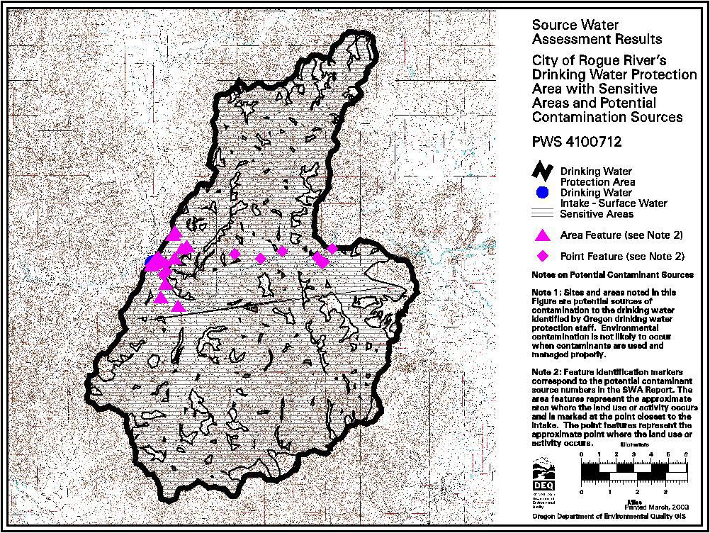
1 SOURCE WATER ASSESSMENT SUMMARY BROCHURE CITY OF ROGUE PWS # WHAT IS A SOURCE WATER ASSESSMENT? The Source Water Assessment was recently completed by the Department of Environmental Quality (DEQ) and the Oregon Department of Human Services (DHS) to identify the surface areas (and/or subsurface areas) that supply water to City of Rogue River s public water system intake and to inventory the potential contaminant sources that may impact the water supply. WHY WAS IT COMPLETED? The Source Water Assessment was completed to provide information so that Rogue River s public water system staff/operator, consumers, and community citizens can begin developing strategies to protect the source of their drinking water, and to minimize future public expenditures for drinking water treatment. The assessment was prepared under the requirements and guidelines of the Federal Safe Drinking Water Act (SDWA). WHAT AREAS ARE INCLUDED IN ROGUE S DRINKING WATER PROTECTION AREA? The drinking water for the City of Rogue River is supplied by an intake on the Rogue River. This public water system serves approximately 2,000 citizens. The intake is located in the Rogue River/Savage Creek/Evans Creek Watershed in the Middle Rogue Subbasin of the Southern Oregon Coastal Basin. In addition, Rogue River uses groundwater wells for drinking water supply. The Source Water Assessment addresses only the surface water component of Rogue River s drinking water supply. The groundwater supply will be addressed separately. The drinking water intakes for the City of Gold Hill, Medford Water Commission, Country View Mobile Home Estates, and Ashland Water Department public water systems are also located on the Rogue River (or its tributaries) upstream of the City of Rogue River intake. The boundaries of Rogue River s portion of the Drinking Water Protection Area (the area between Rogue River s intake and Gold Hill s intake) and a schematic of the portions of the protection area upstream of the Gold Hill intake are illustrated on the figures attached to this summary. In addition, the City of Grants Pass has a drinking water intake on the Rogue River downstream of City of Rogue River s intake. Activities and impacts in the Rogue River drinking water protection area have the potential to also impact downstream users. We encourage other water providers in the Subbasin to work together as you move forward with developing a protection plan or strategies for your drinking water supply. The geographic area providing water to Rogue River s intake (Rogue River s portion of the drinking water protection area) extends upstream approximately 119 miles (2,492 stream miles including the area upstream of the Gold Hill intake) and encompasses a total area of 107 square miles (total of 2,187 square miles including the area upstream of the Gold Hill intake). Included in the Rogue River portion of the delineation are a number of tributaries to the Rogue River, including Ward, Foots, Galls, Sardine, and Kane Creeks. The protection area within an 8-hour travel time from the intake extends approximately 16 miles upstream of the Rogue River intake. It is recommended that the water systems and community consider increased protection within an 8-hour travel time from the intake since eight hours should provide adequate response time to protect the integrity of the public water system intake should a spill or release occur at any crossing or discharge point to the stream. The Rogue River intake is located at an approximate elevation of 1,000 feet and the upper edge of the watershed is located at an elevation of approximately 4,494 feet at Mt. Isabelle.
2 WHAT ARE THE POTENTIAL SOURCES OF CONTAMINATION TO ROGUE S PUBLIC DRINKING WATER SUPPLY? The primary intent of this inventory was to identify and locate significant potential sources of contaminants of concern. The delineated drinking water protection area is primarily dominated by residential and agricultural land uses. The potential contaminant sources identified in the Rogue River s portion of the protection area include four transportation corridors, sewer lines, high density housing, rural homesteads, grazing animals, non-irrigated crops, irrigated crops, forest harvest units, two automobile repair shops, a shopping mall, a wood products mill, wastewater treatment plant, two water treatment plant, gravel pit, fire station, two metal fabrication companies, and one state park. The potential contaminant sources within the drinking water protection area all pose a relatively higher to moderate risk to the drinking water supply with the exception of non-irrigated crops, storage units and the fire station, which presents a lower risk. This provides a quick look at the existing potential sources of contamination that could, if improperly managed or released, impact the water quality in the watershed. WHAT ARE THE RISKS FOR OUR SYSTEM? A total of 30 potential contamination sources were identified within the Rogue River portion of the drinking water protection area. An additional 254 potential sources were identified upstream of the Gold Hill intake. Of the 30 potential sources identified in Rogue River s portion of the protection area, 28 are located in the sensitive areas and 25 are high- to moderaterisk sources within sensitive areas. The sensitive areas within the City of Rogue River drinking water protection area include areas with high soil permeability, high soil erosion potential, high runoff potential and areas within 1000 from the river/streams. The sensitive areas are those where the potential contamination sources, if present, have a greater potential to impact the water supply. The information in this assessment provides a basis for prioritizing areas in and around our community that are most vulnerable to potential impacts and can be used by the City of Rogue River community to develop a voluntary Drinking Water Protection Plan. NEED MORE INFORMATION? City of Rogue River s Source Water Assessment Report provides additional details on the methodology and results of this assessment. The full report is available for review at: Contact the City of Rogue River s staff if you would like additional information on these Source Water Assessment results.
3
4 PWS# ROGUE, CITY OF 1 Transportation - Interstate 5 Runs along the Rogue River Rogue River Field- Within Higher Vehicle use increases the risk for leaks or spills Freeways/State Observation sensitive area. of fuel & other haz. materials. Road building, Highways/Other maintenance & use can increase erosion/slope Heavy Use Roads failure causing turbidity. Over-application or improper handling of pesticides/fertilizers may impact water. 2 Transportation - Highway 99 (Rogue Runs along I-5 and Rogue Rogue River Field- Within Higher Vehicle use increases the risk for leaks or spills Freeways/State River Hwy) River Observation sensitive area. of fuel & other haz. materials. Road building, Highways/Other maintenance & use can increase erosion/slope Heavy Use Roads failure causing turbidity. Over-application or improper handling of pesticides/fertilizers may impact water. 3 Transportation - Central Oregon Runs along I-5 and Rogue Rogue River Field- Within Higher Rail transport elevates the risk for leaks/spills of Railroads Pacific Railroad River Observation sensitive area. fuel & other haz. materials. Installation/maintenance of tracks may increase erosion & slope failure causing turbidity. Overapplication/improper handling of pesticides may impact the water supply. 4 Sewer Lines - Close Sewer Lines Within Rogue River/Gold Hill Rogue River Interview Within Moderate If not properly designed, installed, and Proximity to PWS sensitive area. maintained, sewer lines can impact drinking water, especially adjacent to a waterbody or within the 2-year time-of-travel zone for drinking water wells. 5 Housing - High High Density Within Rogue River/Gold Hill Rogue River Field- Within Moderate Improper use, storage, and disposal of Density (> 1 Housing Observation sensitive area. household chemicals may impact the drinking House/0.5 acres) water supply. Stormwater run-off or infiltration may carry contaminants to drinking water supply. 5/21/2003 Page 1 of 8
5 PWS# ROGUE, CITY OF 6 Furniture/Lumber/Part Ace Hardware Off Broadway Street Rogue River Database (2) Within Moderate Spills, leaks, or improper handling of hazardous s Stores Field- sensitive area. chemical products and other materials in Observation inventory during transportation, use, storage and As known as Main Building Supply. disposal may impact the drinking water supply. UST - Status Unknown Moderate Spills, leaks, or improper handling of stored materials may impact the drinking water supply. As known as Main Building Supply. 7 Automobiles - Repair Bills Auto & Exhaust Off Park Street Rogue River Database (2) Within Moderate Spills, leaks, or improper handling of automotive Shops Field- sensitive area. fluids, solvents, and repair materials during Observation transportation, use, storage and disposal may impact the drinking water supply. 8 Automobiles - Body Kens Auto Body & Off Gilmore Street Rogue River Database (2) Within Moderate Improper management of vehicle paints, Shops Paint Field- sensitive area. thinners, and primer products may impact the Observation drinking water supply. 9 Drinking Water Rogue River Water Off Classick Drive Rogue River Database (2) Within Moderate Treatment chemicals and equipment Treatment Plants Treatment Plant Field- sensitive area. maintenance materials may impact groundwater Observation or surface water source. Interview 10 Parking Lots/Malls (> Rogue River Center Northeast of intake Rogue River Field- Within Moderate Spills and leaks of automotive fluids in parking Risk reduced to Moderate because 50 Spaces) Observation sensitive area. lots may impact the drinking water supply. shopping mall is fairly small in size. 5/21/2003 Page 2 of 8
6 PWS# ROGUE, CITY OF 11 Wood/Pulp/Paper Louisana Pacific Mill East of intake Rogue River Database (2) Within Higher Spills, leaks, or improper handling of wood Processing and Mills Field- sensitive area. preservatives and other chemicals during Observation transportation, use, storage and disposal may impact the drinking water supply. Above Ground Storage Tanks - Excluding Water Moderate Spills, leaks, or improper handling of stored materials may impact the drinking water supply. 12 Fire Station Rogue River Fire East of intake Rogue River Field- Within Lower Spills, leaks, or improper handling of chemicals Station Observation sensitive area. and other materials during transportation, use, storage and disposal may impact the drinking water supply. 13 Metal Trask Industries East of intake Rogue River Field- Outside Moderate Spills, leaks, or improper handling of solvents, Risk reduced to Moderate because Plating/Finishing/Fab Observation sensitive metals, and other chemicals during complex is a small light industry rication areas. for transportation, use, storage and disposal may facility. ROGUE impact the drinking water supply. 14 RV/Mini Storage Rogue River Storage East of intake Rogue River Field- Outside Lower Spills, leaks, or improper handling of automotive Observation sensitive fluids and other materials during transportation, areas. for storage and disposal may impact the drinking ROGUE water supply. 15 Homesteads - Rural - Rural Homesteads Throughout DWPA Rogue River Field- Within Lower If not properly sited, designed, installed, and Septic Systems (< Observation sensitive area. maintained, septic systems can impact drinking 1/acre) water. Use of drain cleaners and dumping household hazardous wastes can result in groundwater contamination. 5/21/2003 Page 3 of 8
7 PWS# ROGUE, CITY OF 16 Managed Forest Land Managed Wards Creek Drainage Rogue River Field- Within Higher Cutting and yarding of trees may contribute to - Clearcut Harvest (< Forestlands- Observation sensitive area. increased erosion, resulting in turbidity and 35 yrs.) Harvest Units chemical changes in drinking water supply. Exact location of units was not Over-application or improper handling of determined. Contact indicated some harvesting in Wards Creek. Will pesticides or fertilizers may impact drinking need to be verified. water source. Potential risk should be verified during enhanced inventory. 17 Transmission Lines - Transmission Lines Throughout DWPA Rogue River Field- Within Higher Construction and corridor maintenance may Right-of-Ways Observation sensitive area. contribute to increased erosion and turbidity in drinking water supply. Over-application or improper handling of pesticides or fertilizers may impact drinking water supply. 18 Crops - Irrigated (inc. Irrigated Crops Throughout DWPA Rogue River Field- Within Higher Over-application or improper handling of orchards, vineyards, Observation sensitive area. pesticides/fertilizers may impact drinking water. nurseries, Excessive irrigation may transport contaminants greenhouses) or sediments to groundwater/surface water through runoff. Drip-irrigated crops are considered to be a low risk. 19 Crops - Nonirrigated Non-Irrigated Throughout DWPA Rogue River Field- Within Lower Over-application or improper handling of (inc. Christmas trees, Crops Observation sensitive area. pesticides/fertilizers may impact drinking water. grains, grass seed, Some agricultural practices may result in pasture) excess sediments discharging to surface waters, but non-irrigated crops are generally considered to be a low risk. 5/21/2003 Page 4 of 8
8 PWS# ROGUE, CITY OF 20 Lagoons/Liquid Valley of the Rogue Southeast of intake. Rogue River Database (2) Within Higher Improper seepage or overflows of liquid wastes Wastes State Park Field- sensitive area. may impact the drinking water supply. Observation Large park that is situated right Interview along banks of the Rogue River approximately 2 miles upstream from intake. High level of recreation at this park. River Recreation - Heavy Use (inc. campgrounds) Moderate Inadequate disposal of human wastes may contribute bacteria and nutrients to the drinking water supply. Heavy use may contribute to Large park that is situated right along banks of the Rogue River streambank erosion causing turbidity. Fuel approximately 2 miles upstream spills and emissions may also contribute to from intake. High level of recreation contamination. at this park. Large Capacity Septic Moderate If not properly sited, designed, installed, and Systems (serves > 20 maintained, septic systems can impact drinking people) - Class V water. Large park that is situated right UICs along banks of the Rogue River approximately 2 miles upstream from intake. High level of recreation at this park. Parks Moderate Over-application or improper handling of pesticides/fertilizers may impact drinking water. Excessive irrigation may cause transport of Large park that is situated right along banks of the Rogue River contaminants through runoff. Heavy use along approximately 2 miles upstream edge of waterbody may contribute to erosion, from intake. High level of recreation causing turbidity. at this park. 21 Grazing Animals (> 5 Grazing Animals Throughout DWPA Rogue River Field- Within Higher Improper storage and management of animal large animals or Observation sensitive area. wastes may impact drinking water supply. equivalent/acre) Concentrated livestock may contribute to erosion and sedimentation of surface water bodies. 5/21/2003 Page 5 of 8
9 PWS# ROGUE, CITY OF 22 Other _Irrigation Irrigation Canal Northeast/Southeast of intake Rogue River Field- Within Higher The impacts of this potential contaminant source Canal Observation sensitive area. will be addressed during the enhanced inventory. Gold Hill Irrigation Canal and Grants Pass Irrigation Canal both found within DWPA. Unsure exact location of outfalls for canals. Potential risk should be verified during enhanced inventory. 23 Utility Stations - Substation Directly across from intake Rogue River Field- Within Moderate Spills, leaks, or improper handling of chemicals Risk reduced to Moderate because Maintenance Observation sensitive area. and other materials including PCBs during substation is very small. Transformer Storage transportation, use, storage and disposal may impact the drinking water supply. Unknown if any other substations are within DWPA. 24 Mines/Gravel Pits Advanced East of intake. Off Hwy 99 Gold Hill Field- Within Higher Spills, leaks, or improper handling of chemicals Aggregate Inc. Observation sensitive area. and wastes generated in mining operations or from heavy equipment may impact the drinking water supply. 25 Crops - Irrigated (inc. Del Rio Vineyard East of intake. Along Hwy 99 Gold Hill Database (2) Within Higher Over-application or improper handling of orchards, vineyards, Field- sensitive area. pesticides/fertilizers may impact drinking water. nurseries, Observation Excessive irrigation may transport contaminants greenhouses) or sediments to groundwater/surface water through runoff. Drip-irrigated crops are considered to be a low risk. 5/21/2003 Page 6 of 8
10 PWS# ROGUE, CITY OF 26 UST - Status Gold Hill East of intake. Off Sardine Gold Hill Database (2) Within Moderate Spills, leaks, or improper handling of stored Unknown Wastewater Road. Field- sensitive area. materials may impact the drinking water supply. Treatment Plant Observation Wastewater Treatment Higher Improper management of wastewater, treatment Plants/Collection chemicals, or equipment maintenance materials Stations may impact drinking water supply. 27 Metal Sweed Machinery East of intake. Off 2nd Ave Gold Hill Database (2) Within Higher Spills, leaks, or improper handling of solvents, Plating/Finishing/Fab Field- sensitive area. metals, and other chemicals during rication Observation transportation, use, storage and disposal may impact the drinking water supply. 28 Metal Ideal Basic Industries East of intake. Off 4th Ave Gold Hill Database (2) Within Higher Spills, leaks, or improper handling of solvents, Plating/Finishing/Fab sensitive area. metals, and other chemicals during rication transportation, use, storage and disposal may PCS location based on regulatory impact the drinking water supply. database search - needs verification. Potential risk should be verified during enhanced inventory. 5/21/2003 Page 7 of 8
11 PWS# ROGUE, CITY OF 29 Automobiles - Gas Gold Hill Texaco East of intake Gold Hill Database (2) Within Moderate Spills, leaks, or improper handling of fuels and Stations Field- sensitive area. other materials during transportation, transfer, Observation and storage may impact the drinking water There are several gas stations that supply. are near the intake but are just outside the DWPA. These gas stations may also be potential contaminant sources. UST - Lower Spills or improper handling during tank filling or Upgraded/Registered product distribution may impact the drinking - Active water supply. There are several gas stations that are near the intake but are just outside the DWPA. These gas stations may also be potential contaminant sources. 30 Drinking Water Gold Hill Water East of intake. Off Hwy 234 Gold Hill Database (2) Within Moderate Treatment chemicals and equipment Treatment Plants Treatment Plant Field- sensitive area. maintenance materials may impact groundwater Observation or surface water source. Treatment plant may be located just outside of drinking water protection area. Location needs verified. 5/21/2003 Page 8 of 8
SOURCE WATER ASSESSMENT SUMMARY BROCHURE
 SOURCE WATER ASSESSMENT SUMMARY BROCHURE MILL CITY WATER DEPARTMENT PWS # 4100520 WHAT IS A SOURCE WATER ASSESSMENT? The Source Water Assessment was recently completed by the Department of Environmental
SOURCE WATER ASSESSMENT SUMMARY BROCHURE
 SOURCE WATER ASSESSMENT SUMMARY BROCHURE CITY OF OAKLAND PWS # 4100581 WHAT IS A SOURCE WATER ASSESSMENT? The Source Water Assessment was recently completed by the Department of Environmental Quality (DEQ)
SOURCE WATER ASSESSMENT SUMMARY BROCHURE
 SOURCE WATER ASSESSMENT SUMMARY BROCHURE STAYTON WATER SUPPLY PWS # 4100843 WHAT IS A SOURCE WATER ASSESSMENT? The Source Water Assessment was recently completed by the Department of Environmental Quality
SOURCE WATER ASSESSMENT SUMMARY BROCHURE
 SOURCE WATER ASSESSMENT SUMMARY BROCHURE CITY OF ROSEBURG PWS # 4100720 WHAT IS A SOURCE WATER ASSESSMENT? The Source Water Assessment was recently completed by the Department of Environmental Quality
SOURCE WATER ASSESSMENT SUMMARY BROCHURE
 SOURCE WATER ASSESSMENT SUMMARY BROCHURE CITY OF CAVE JUNCTION PWS # 4100971 WHAT IS A SOURCE WATER ASSESSMENT? The Source Water Assessment was recently completed by the Department of Environmental Quality
SOURCE WATER ASSESSMENT SUMMARY BROCHURE
 SOURCE WATER ASSESSMENT SUMMARY BROCHURE TILLER ELEMENTARY, SD #15 PWS # 4192139 WHAT IS A SOURCE WATER ASSESSMENT? The Source Water Assessment was recently completed by the Department of Environmental
SOURCE WATER ASSESSMENT SUMMARY BROCHURE
 SOURCE WATER ASSESSMENT SUMMARY BROCHURE USFS TILLER RANGER STATION PWS # 4101092 WHAT IS A SOURCE WATER ASSESSMENT? The Source Water Assessment was recently completed by the Department of Environmental
SOURCE WATER ASSESSMENT SUMMARY BROCHURE
 SOURCE WATER ASSESSMENT SUMMARY BROCHURE USFS WOLF CREEK JOB CORPS PWS # 4101095 WHAT IS A SOURCE WATER ASSESSMENT? The Source Water Assessment was recently completed by the Department of Environmental
SOURCE WATER ASSESSMENT SUMMARY BROCHURE
 SOURCE WATER ASSESSMENT SUMMARY BROCHURE PGE BEAVER GENERATING STATION PWS # 4105246 WHAT IS A SOURCE WATER ASSESSMENT? The Source Water Assessment was recently completed by the Department of Environmental
SOURCE WATER ASSESSMENT SUMMARY BROCHURE
 SOURCE WATER ASSESSMENT SUMMARY BROCHURE CITY OF GOLD HILL PWS # 4100333 WHAT IS A SOURCE WATER ASSESSMENT? The Source Water Assessment was recently completed by the Department of Environmental Quality
SOURCE WATER ASSESSMENT SUMMARY BROCHURE
 SOURCE WATER ASSESSMENT SUMMARY BROCHURE CITY OF AMITY PWS # 4100041 WHAT IS A SOURCE WATER ASSESSMENT? The Source Water Assessment was recently completed by the Department of Environmental Quality (DEQ)
SOURCE WATER ASSESSMENT SUMMARY BROCHURE
 SOURCE WATER ASSESSMENT SUMMARY BROCHURE PP&L TOKETEE VILLAGE PWS # 4101012 WHAT IS A SOURCE WATER ASSESSMENT? The Source Water Assessment was recently completed by the Department of Environmental Quality
SOURCE WATER ASSESSMENT SUMMARY BROCHURE
 SOURCE WATER ASSESSMENT SUMMARY BROCHURE WINSTON-DILLARD WATER DISTRICT PWS # 4100957 WHAT IS A SOURCE WATER ASSESSMENT? The Source Water Assessment was recently completed by the Department of Environmental
SOURCE WATER ASSESSMENT SUMMARY BROCHURE
 SOURCE WATER ASSESSMENT SUMMARY BROCHURE CORBETT WATER DISTRICT PWS # 4100359 WHAT IS A SOURCE WATER ASSESSMENT? The Source Water Assessment was recently completed by the Department of Environmental Quality
SOURCE WATER ASSESSMENT SUMMARY BROCHURE RAINIER WATER DEPARTMENT PWS #
 SOURCE WATER ASSESSMENT SUMMARY BROCHURE RAINIER WATER DEPARTMENT PWS # 4100689 WHAT IS A SOURCE WATER ASSESSMENT? The Source Water Assessment was recently completed by the Department of Environmental
SOURCE WATER ASSESSMENT SUMMARY BROCHURE
 SOURCE WATER ASSESSMENT SUMMARY BROCHURE CITY OF ESTACADA - PWS # 4100279 WHAT IS A SOURCE WATER ASSESSMENT? The Source Water Assessment was recently completed by the Department of Environmental Quality
Dunes City Drinking Water Source Assessment and Potential Planning Strategies. Prepared by Lane Council of Governments
 Dunes City Drinking Water Source Assessment and Potential Planning Strategies Prepared by Lane Council of Governments December 2002 Dunes City Drinking Water Source Assessment and Potential Planning Strategies
Wellhead Protection Inventory Form. Table of Potential Land Use
 Wellhead Protection Inventory Form Survey Conducted by: Date: Instructions: The attached map illustrates property that is included in the approximate wellhead protection area (WHPA). The following table
Streamlines V2, n2 (May 1997) A Newsletter for North Carolina Water Supply Watershed Administrators
 A Newsletter for North Carolina Water Supply Watershed Administrators") Page 1 of 5 STREAMLINES A Newsletter for North Carolina Water Supply Watershed Administrators Volume 2, Number 2 May 1997 Non-Point Source (NPS) Pollution This issue of Streamlines provides basic information
Page 1 of 5 STREAMLINES A Newsletter for North Carolina Water Supply Watershed Administrators Volume 2, Number 2 May 1997 Non-Point Source (NPS) Pollution This issue of Streamlines provides basic information
rt.= Source Water Assessment Report City of Newport, Oregon I l :( 1 PWS # October 1, 2002 Prepared for City of Newport Prepared by
 Source Water Assessment Report City of Newport, Oregon PWS #41566 October 1, 22 Prepared for City of Newport Prepared by rt.= I l :( 1 Stale of Oregon Department of Environmental Quality Water Quality
CITY OF HOYT LAKES, MINNESOTA SOURCE WATER ASSESSMENT
 CITY OF HOYT LAKES, MINNESOTA SOURCE WATER ASSESSMENT November 2002 Public Water Supplier ID 1690028 Facility Contact: Minnesota Department of Health Contact: Mr. Floyd Nelson, Supervisor Ms. Beth Kluthe
Lake Creek Watershed Management Plan Public Meeting. Arrowhead Lake May 3, :00 PM
 Lake Creek Watershed Management Plan Public Meeting Arrowhead Lake May 3, 2018 6:00 PM Agenda I. Welcome and Introductions II. III. IV. Watershed Basics Overview of Lake Creek Watershed Elements of a Successful
Our Eastern Shore Groundwater Part IV Groundwater Quality on the Eastern Shore: How safe is our groundwater and are there ways we can protect it?
 Our Eastern Shore Groundwater Part IV Groundwater Quality on the Eastern Shore: How safe is our groundwater and are there ways we can protect it? Britt McMillan, Malcolm Pirnie, Inc. Mercury Venus Mars
Source Water Assessment Report
 Source Water Assessment Report City of Cave Junction, Oregon PWS #41971 March 24, 23 Prepared for City of Cave Junction Prepared by ' I l =< 1 State of Oregon Department of Environ mental Quality Water
Water Quality Regulatory Programs and Our Citywide EPA / DEQ Stormwater Permit. Public Works Engineering City Council Briefing June 7, 2016
 Water Quality Regulatory s and Our Citywide EPA / DEQ Stormwater Permit Public Works Engineering City Council Briefing June 7, 2016 Briefing Topics Introduction: Regulatory Overview Elements of the MS4
The effects of pollution. What is stormwater runoff? Why is stormwater runoff a problem?
 What is stormwater runoff? Stormwater runoff occurs when precipitation from rain or snowmelt flows over the ground. Impervious surfaces like driveways, sidewalks, and streets prevent stormwater from naturally
Summary of Basin Characteristics and Facilities. General Land-use Characteristics: Withdrawal and Discharge Sites: Sampling Site Statistics:
 This report was prepared by the Kentucky Water Research Institute as a product of the statewide Kentucky Watershed Management process. Information presented in this report was collected from many sources.
Contractors, Illicit Discharges, & Best Management Practices. Chris Allen Stormwater Inspector
 Contractors, Illicit Discharges, & Best Management Practices Chris Allen Stormwater Inspector What is an Illicit Discharge? Georgetown County Stormwater Ordinance defines an Illicit Discharge as: Any activity
CITY OF MINNEAPOLIS SOURCE WATER ASSESSMENT
 CITY OF MINNEAPOLIS SOURCE WATER ASSESSMENT September 2001 PWS ID 1270024 City Contact: Minnesota Department of Health Contact: Mr. Adam Kramer Mr. Terry Bovee, Planner Minneapolis Public Works Source
Maitland Valley WATERSHED
 Maitland Valley WATERSHED Report Card 2018 Maitland Conservation has prepared this report card as a summary of the state of your forests, wetlands, and water resources. WHERE ARE WE? We are one of 36 Conservation
City of Valdosta Land Development Regulations
 Chapter 324 Section 324-1 Environmental Planning Criteria Protection of Groundwater Recharge Areas (A) Purpose and Intent. Pursuant to O.C.G.A. 12-2-8 and the Georgia Department of Natural Resources (DNR),
Source Water Assessment Report
 Source Water Assessment Report City of Reedsport, Oregon PWS #41699 January 9, 23 Prepared for City of Reedsport Prepared by I l :( 1 State of Oregon Department ot Environmental Quality Water Quality Division
Welcome The purpose of this information is to give you an opportunity to:
 Welcome The purpose of this information is to give you an opportunity to: Learn how the Ada County Highway District (ACHD) is meeting requirements and milestones in our Phase II Stormwater Management Plan,
THE WATERSHED The watershed is an area of land that drains into a stream. This includes both the surface runoff and groundwater. Because a stream is m
 Understanding Streams A stream is the product of its watershed. Good land use in the watershed will be reflected in the stream. MOST PEOPLE enjoy the captivating qualities of flowing water. But streams
Voluntary Water Quality Conservation Plan
 Voluntary Water Quality Conservation Plan Plan Table of Contents A. Mid Coast Agricultural Water Quality Management Area Rules and Plan Overview B. Landowner Resource/Practice Inventory C. Recommended
The Lake Maumelle watershed
 Source Water Protection Central Arkansas: Programs & Practices Martin Maner, PE and Trevor Clements Implementing Adaptive Management in Central Arkansas Introduction The Lake Maumelle watershed in central
Source Water Assessment and Protection (SWAP) Report for Hudson Water Supply
 Report for Hudson Water Supply") Massachusetts Department of Environmental Protection Source Water Assessment and Protection (SWAP) Report for Hudson Water Supply What is SWAP? The Source Water Assessment Program (SWAP), established under
Massachusetts Department of Environmental Protection Source Water Assessment and Protection (SWAP) Report for Hudson Water Supply What is SWAP? The Source Water Assessment Program (SWAP), established under
LIVINGSTON COUNTY DRAIN COMMISSIONER Brian Jonckheere
 MICHIGAN DEPARTMENT OF ENVIRONMENTAL QUALITY GENERAL STORM WATER PERMIT MIG619000 ILLICIT DISCHARGE ELIMINATION PLAN FOR LIVINGSTON COUNTY DRAIN COMMISSIONER Brian Jonckheere Table of Contents Section
Source Water Assessment Program (SWAP) Report for Heath Elementary School
 Report for Heath Elementary School") Source Water Assessment Program (SWAP) Report for Heath Elementary School What is SWAP? The Source Water Assessment Program (SWAP), established under the federal Safe Drinking Water Act, requires every
Source Water Assessment Program (SWAP) Report for Heath Elementary School What is SWAP? The Source Water Assessment Program (SWAP), established under the federal Safe Drinking Water Act, requires every
CHAPTER 5. NPDES PHASE II EVALUATION
 CHAPTER 5. NPDES PHASE II EVALUATION A Stormwater Management Program for Medford was developed and submitted to the DEQ to meet requirements of the NPDES Phase II program. Phase II regulations require
Safe Water Depends on Us.
 DRINKING WATER PROTECTION A Citizen s Guide to Getting Involved Safe Water Depends on Us. Learn What You Can Do. SAFE WATER FOR WEST VIRGINIA 1 WHERE DOES YOUR DRINKING WATER COME FROM? source water Source
Drinking Water Source Protection General Information on Funding and Rating Projects
 Drinking Water Source Protection General Information on Funding and Rating Projects The FFY-2014 Funding Drinking Water Source Protection (DWSP) Letter of Interest (LOI) solicitation will be used to gather
6.1 Introduction to Wastewater Issues
 Section 6: Water Pollution This Section will help you: Understand if you generate industrial wastewater; Understand where your wastewater goes; Make sure you meet requirements for floor drains; Properly
)to HS. Source Water Assessment Report. Langlois, Oregon 111:( 1 PWS # December 12, Prepared for. Langlois Water District.
to HS. Source Water Assessment Report. Langlois, Oregon 111:( 1 PWS # December 12, Prepared for. Langlois Water District.") Source Water Assessment Report Langlois Water District Langlois, Oregon PWS #4 1 466 December 12, 22 Prepared for Langlois Water District Prepared by 111:( 1 Slate of Oregon Department of Environmental
Source Water Assessment Report Langlois Water District Langlois, Oregon PWS #4 1 466 December 12, 22 Prepared for Langlois Water District Prepared by 111:( 1 Slate of Oregon Department of Environmental
You are the solution to water pollution. A guide for preventing water pollution in your own backyard
 You are the solution to water pollution A guide for preventing water pollution in your own backyard Even if you live miles away from a river or stream, you may be polluting the water without even knowing
Surface Water Management
 Surface Water Management Figure 7: Examples of Nonpoint Source Pollution The water quality leaving the metropolitan area is as good as the water quality entering the metropolitan area, and in compliance
Cannon River One Watershed, One Plan. POLICY COMMITTEE MEETING January 10, 2018 Rice County Government Center Faribault, MN
 Cannon River One, One Plan POLICY COMMITTEE MEETING January 10, 2018 Rice County Government Center Faribault, MN TASK Task 1. Aggregate Existing Physical & Spatial Data 1A. Create project maps 1B. Meeting
)to HS. Source Water Assessment Report. Rock Creek Water District Grand Ronde, Oregon PWS # i l :C 1. March 24, 2003
to HS. Source Water Assessment Report. Rock Creek Water District Grand Ronde, Oregon PWS # i l :C 1. March 24, 2003") Source Water Assessment Report Rock Creek Water District Grand Ronde, Oregon PWS #41337 March 24, 23 Prepared for Rock Creek Water District Prepared by ~ ~ i l :C 1 State of OrBgOn Department of Environmental
Source Water Assessment Report Rock Creek Water District Grand Ronde, Oregon PWS #41337 March 24, 23 Prepared for Rock Creek Water District Prepared by ~ ~ i l :C 1 State of OrBgOn Department of Environmental
Drinking Water Source Assessment
 Drinking Water Source Assessment Water System System name County Water Source Source name Assessment Date Month, year California Department of Health Services Drinking Water Field Operations Branch DHS
rt.: )to HS Source Water Assessment Report City of The Dalles, Oregon PWS # i l =< 1 April 10, 2003 Prepared for City of The Dalles Prepared by
to HS Source Water Assessment Report City of The Dalles, Oregon PWS # i l =< 1 April 10, 2003 Prepared for City of The Dalles Prepared by") Source Water Assessment Report City of The Dalles, Oregon PWS #41869 April 1, 23 Prepared for City of The Dalles Prepared by rt.: i l =< 1 State of Oregon Department Qf Environmental Quality Water Quality
Source Water Assessment Report City of The Dalles, Oregon PWS #41869 April 1, 23 Prepared for City of The Dalles Prepared by rt.: i l =< 1 State of Oregon Department Qf Environmental Quality Water Quality
Septic Systems. A Complete Guide To Understanding How They Work and How To Keep Them Healthy
 Septic Systems A Complete Guide To Understanding How They Work and How To Keep Them Healthy What Is A Septic System? Wastewater from a home, which includes the water from toilets, laundry, showers, sinks
OKLAHOMA DEPARTMENT OF ENVIRONMENTAL QUALITY PUBLIC NOTICE. June 24, 2010 AVAILABILITY OF DRAFT BACTERIA TMDL FOR THE BIRD CREEK AREA WATERSHED
 Steve Thompson Executive Director OKLAHOMA DEPARTMENT OF ENVIRONMENTAL QUALITY Brad Henry Governor PUBLIC NOTICE June 24, 2010 AVAILABILITY OF DRAFT BACTERIA TMDL FOR THE BIRD CREEK AREA WATERSHED REQUEST
Source Water Assessment and Protection (SWAP) Report for Northampton Water Department
 Report for Northampton Water Department") Massachusetts Department of Environmental Protection Source Water Assessment and Protection (SWAP) Report for Northampton Water Department What is SWAP? The Source Water Assessment Program (SWAP), established
Massachusetts Department of Environmental Protection Source Water Assessment and Protection (SWAP) Report for Northampton Water Department What is SWAP? The Source Water Assessment Program (SWAP), established
Lower Howard Creek W atershed Watershed Number:
 W atershed Watershed Number: 5255 Location Map Bourbon Lexington Ú Clark Mount Sterling Ú Fayette %g 6 Montgom ery %g927 %g 75 %g 8 %g 923 %g927 58 %g9 %g337 %g92 3 %g92 3%g 627 Ú W inchester %g9 7 %g89
Strategic Plan Fourche Creek Watershed HUA #: Lower Arkansas-Maumelle Date Adopted: January 2002
 Strategic Plan Fourche Creek Watershed HUA #: er Arkansas-Maumelle 11110207 Date Adopted: January 2002 Watershed Location Map Background Information 1. Water quality impairments and concerns are identified
Source Water Assessment Report
 Source Water Assessment Report PP&L Toketee Village, Oregon PWS #41112 August 3, 21 Prepared for PP&L Toketee Village Prepared by ~ ~ I l:c l Stale o1 Oregon Department of Environmental Quality Water Quality
Grants Pass Water Quality Monitoring
 Grants Pass Water Quality Monitoring 2003-2005 Rogue Valley Council of Governments April 2005 Rogue Valley Council of Governments Natural Resources Department 155 North First Street Central Point, Oregon
Source Water Assessment Program (SWAP) Report for Rowe Elementary School
 Report for Rowe Elementary School") Source Water Assessment Program (SWAP) Report for Rowe Elementary School What is SWAP? The Source Water Assessment Program (SWAP), established under the federal Safe Drinking Water Act, requires every
Source Water Assessment Program (SWAP) Report for Rowe Elementary School What is SWAP? The Source Water Assessment Program (SWAP), established under the federal Safe Drinking Water Act, requires every
Non-point source pollution now accounts for over 75% of Pennsylvania s total water pollution
 2. Non-point Source Pollution Living on the Landscape and How We Affect Our Shared Water Resources by John Jose, Watershed Specialist, Pike County Conservation District Water is the most critical resource
CITY OF ST. PAUL SOURCE WATER ASSESSMENT
 CITY OF ST. PAUL SOURCE WATER ASSESSMENT September 2001 PWS ID 1620026 City Contact: Mr. David Schuler St. Paul Regional Water Services 8 Fourth Street East St. Paul, Minnesota 55101 Telephone Number:
DEKALB COUNTY STORMWATER MANAGEMENT PLAN PHASE 2
 DEKALB COUNTY STORMWATER MANAGEMENT PLAN PHASE 2 Introduction DeKalb County, Illinois, located approximately 50 miles west of Lake Michigan, is rectangular in shape, with a north/south dimension of 36
Wellhead Protection Issues Related to Mining Activities Minnesota Rural Water Conference March 4, 2014
 Wellhead Protection Issues Related to Mining Activities Minnesota Rural Water Conference March 4, 2014 Terry Bovee Source Water Protection Unit Minnesota Department of Health Purpose Response to requests
Protect Your Community s Drinking Water Supply While Managing Stormwater in Your Community
 Protect Your Community s Drinking Water Supply While Managing Stormwater in Your Community Stormwater impacts drinking water what can you do about it? State and Federal requirements protect supplies from
C O M P R E H E N S I V E P R O T E C T I O N & R E S T O R AT I O N P L A N. f or th e
 C O M P R E H E N S I V E P R O T E C T I O N & R E S T O R AT I O N P L A N f or th e R O S S B A R NE T T R E SERV O I R WATERS HED, MI S S I S S I P P I E X E C U T I V E S U M M A R Y O C T O B E R
TITLE 252. DEPARTMENT OF ENVIRONMENTAL QUALITY CHAPTER 616. INDUSTRIAL WASTEWATER SYSTEMS SUBCHAPTER 1. INTRODUCTION [AMENDED]
![TITLE 252. DEPARTMENT OF ENVIRONMENTAL QUALITY CHAPTER 616. INDUSTRIAL WASTEWATER SYSTEMS SUBCHAPTER 1. INTRODUCTION [AMENDED]](/thumbs/90/103047993.jpg "TITLE 252. DEPARTMENT OF ENVIRONMENTAL QUALITY CHAPTER 616. INDUSTRIAL WASTEWATER SYSTEMS SUBCHAPTER 1. INTRODUCTION [AMENDED]") TITLE 252. DEPARTMENT OF ENVIRONMENTAL QUALITY CHAPTER 616. INDUSTRIAL WASTEWATER SYSTEMS SUBCHAPTER 1. INTRODUCTION [AMENDED] 252:616-1-1. Purpose 252:616-1-2. Definitions [AMENDED] 252:616-1-2. Definitions
TITLE 252. DEPARTMENT OF ENVIRONMENTAL QUALITY CHAPTER 616. INDUSTRIAL WASTEWATER SYSTEMS SUBCHAPTER 1. INTRODUCTION [AMENDED] 252:616-1-1. Purpose 252:616-1-2. Definitions [AMENDED] 252:616-1-2. Definitions
rt.: Source Water Assessment Report S.W. Lincoln County Water District Waldport, Oregon I 1 =< 1 Stale of Oregon Department of environmental Quality
 Source Water Assessment Report S.W. Lincoln County Water District Waldport, Oregon PWS #41925 August 17, 21 Prepared for S.W. Liucoln County Water District Prepared by rt.: ~ I 1 =< 1 Stale of Oregon Department
Why should you be concerned?
 Farm & Home Water Quality Assessment Protecting Your Water Quality Through a Farm & Home Assessment Why should you be concerned? About 95 percent of the families who live in the country get water from
Agricultural/Rural Riparian Buffer Analysis
 Agricultural/Rural Riparian Buffer Analysis December 2014 Executive Summary The Agricultural/Rural Riparian Buffer Analysis was developed from a 2014 analysis of current requirements for the riparian areas
By Paul Robinson Research Director Southwest Research and Information Center PO Box 4524 Albuquerque, NM
 Fact Sheet Concerning Sources of Groundwater Contamination at the Technical Area Five (TA-V), the Tijeras Arroyo Groundwater (TAG) and the Burn Site Areas of Concern at Sandia National Laboratories By
How does groundwater get in the earth? Where does it come from?
 What is Groundwater? How does groundwater get in the earth? Where does it come from? Groundwater begins as rain or snow that falls to the ground. This is called precipitation. Only a small portion of this
Supplemental Guide II-Delineations
 Supplemental Guide II-Delineations Contents Source Water Protection Area Delineation... 1 Delineation Criteria for Systems Using Groundwater Sources... 2 Time of Travel... 4 Flow Boundaries... 4 Delineation
POLLUTION PREVENTION AFTER CONSTRUCTION
 POLLUTION PREVENTION AFTER CONSTRUCTION..CHAPTER.. 10 This chapter describes the pollution prevention measures to be taken once the site has been permanently and finally stabilized and no additional construction
SOURCE WATER ASSESSMENT PROJECT:
 SOURCE WATER ASSESSMENT PROJECT: An Assessment of Potential for Pollution of Surface Drinking Water Supply Sources Prepared by the Atlanta Regional Commission for Cherokee County Water & Sewer Authority
DC STORMWATER PLAN CONSOLIDATED TOTAL MAXIMUM DAILY LOAD (TDML) IMPLEMENTATION PLAN
 IMPLEMENTATION PLAN") DC STORMWATER PLAN CONSOLIDATED TOTAL MAXIMUM DAILY LOAD (TDML) IMPLEMENTATION PLAN CONTENTS Introduction 1 The Challenge 5 The Solution 7 Tracking Progress 11 What can you do? 15 INTRODUCTION The DC Stormwater
DC STORMWATER PLAN CONSOLIDATED TOTAL MAXIMUM DAILY LOAD (TDML) IMPLEMENTATION PLAN CONTENTS Introduction 1 The Challenge 5 The Solution 7 Tracking Progress 11 What can you do? 15 INTRODUCTION The DC Stormwater
SOURCE WATER ASSESSMENT SUMMARY BROCHURE
 SOURCE WATER ASSESSENT SUARY BROCURE OREGON CITY - SOUT FORK WATER BOARD, PWS #40059 NORT CACKAAS COUNTY WATER COISSION, PWS #400580 AND CACKAAS RIVER WATER, PWS #40087 WAT IS A SOURCE WATER ASSESSENT?
Appendix X: Non-Point Source Pollution
 Appendix X: Non-Point Source Pollution Sources Nonpoint source of pollution, unlike pollution from industrial and sewage treatment plants, comes from many different sources. Nonpoint source pollution is
Storm Water Permitting Requirements for Construction Activities. John Mathews Storm Water Program Manager Division of Surface Water
 Storm Water Permitting Requirements for Construction Activities John Mathews Storm Water Program Manager Division of Surface Water Why Permit Storm Water? Impacts During Construction Not an issue until
Chapter 2: Conditions in the Spring Lake Watershed related to Stormwater Pollution
 Chapter 2: Conditions in the Spring Lake Watershed related to Stormwater Pollution To identify the primary causes and consequences of stormwater discharges to Spring Lake and its adjoining waterbodies,
Source Water Assessment and Protection (SWAP) Report for Acton Water Supply District
 Report for Acton Water Supply District") Massachusetts Department of Environmental Protection Source Water Assessment and Protection (SWAP) Report for Acton Water Supply District What is SWAP? The Source Water Assessment and Protection (SWAP)
Massachusetts Department of Environmental Protection Source Water Assessment and Protection (SWAP) Report for Acton Water Supply District What is SWAP? The Source Water Assessment and Protection (SWAP)
OF CONTENTS 14.0 COUNTY OF BRANT...
 TABLE OF CONTENTS 14.0 COUNTY OF BRANT... 14-1 14.1 Definitions... 14-1 14.2 County Of Brant Source Protection Plan Policies... 14-2 14.3 Policies Addressing Prescribed Drinking Water Threats... 14-6 14.4
Pollutants in our Waters
 Pollutants in our Waters CARIWIN Advanced Course in IWRM September 17, 2007 Apurva Gollamudi Brace Centre for Water Resources Management McGill University It isn t the pollution that s harming the environment.
CARANCAHUA BAY WATERSHED PROTECTION PLAN. Allen Berthold, Michael Schramm November 2, 2017
 CARANCAHUA BAY WATERSHED PROTECTION PLAN 1 Allen Berthold, Michael Schramm November 2, 2017 Today s Meeting 1. Introductions and recap of last meeting 2. Water quality in Carancahua Bay and West Carancahua
Tackling Non-point Source Water Pollution in British Columbia
 Water Quality Clean Water Tackling Non-point Source Water Pollution in British Columbia Our well-being depends on sustainable supplies of clean water for our physical health and for a healthy environment
Source Water Assessment and Protection (SWAP) Report for Bellingham DPW Water & Sewer Division
 Report for Bellingham DPW Water & Sewer Division") Massachusetts Department of Environmental Protection Source Water Assessment and Protection (SWAP) Report for Bellingham DPW Water & Sewer Division What is SWAP? The Source Water Assessment Protection
Massachusetts Department of Environmental Protection Source Water Assessment and Protection (SWAP) Report for Bellingham DPW Water & Sewer Division What is SWAP? The Source Water Assessment Protection
Table 1. Relationship between critical areas and key functions. Shaded areas represent functions associated with each critical area. Storage.
 Flow Storage Nutrients Temperature Bacteria Contaminants Cowlitz County Voluntary Stewardship Program 4 Goals, Benchmarks, Strategies and Indicators 4.1 Approach Goals and Benchmarks Critical Areas Functions
PUBLIC DRINKING WATER WORKING GROUP REPORT
 PUBLIC DRINKING WATER WORKING GROUP REPORT FINAL REVIEW DRAFT Protecting Drinking Water In the Southern Willamette Valley Groundwater Management Area Prepared by Lane Council of Governments March 2006
W atershed Number:
 %g 2 8 %g 2 8 (Lower) Watershed W atershed Number: 522 Location Map %g Fin castle %g2 6 %g2 7 (Lower) Watershed Lee Bea ttyville %g %g 52 %g %g 5 2 %g 5 2 %g 7 8 %g 7 8 %g2 69 %g 5 2 %g 5 %g 52 %g Jackso
INTRODUCTION TO HOBBY FARMING AND WATER QUALITY
 SECTION ONE INTRODUCTION TO HOBBY FARMING AND WATER QUALITY This is a handbook for owners of Hobby Farms - small scale farms operated primarily as a residential lifestyle - to provide their owners with
Bluff Creek One Water
 Bluff Creek One Water The Bluff Creek Watershed has no lakes within its boundaries. As the westernmost watershed within the District, land use changes from agricultural to residential have occurred relatively
STORMWATER MANAGEMENT PLAN CONTENTS CHECKLIST Stormwater Management Plan Contents. SWMP Page # or Reference Location Yes/No
 STORMWATER MANAGEMENT PLAN CONTENTS CHECKLIST Stormwater Management Plan Contents Site Description A description of construction activity. The proposed sequence for major activities. Estimates of the total
SUBURBAN EDGE COMMUNITY ROLE COUNCIL ROLE ALL COMMUNITIES SUBURBAN EDGE
 Orderly and Efficient Land Use Align land use, development patterns, and infrastructure to make the best use of public and private investment. Plan and stage development for forecasted growth through 2040
What is a stormwater utility fee?
 What is a stormwater utility fee? A stormwater utility fee is similar to a water or sewer utility fee. In essence, customers pay a fee to convey stormwater from their properties. The City of Goodlettsville
Reservoir age, increasing human population,
 B-6249 02/12 Eagle Mountain Watershed Management Brent Clayton, Justin Mechell, David Waidler and Clint Wolfe* Reservoir age, increasing human population, and changing land uses have prompted the development
Existing Conditions and Environmental Consequences Water Quality
 3.6 3.6.1 HOW IS WATER QUALITY ASSESSED? The Clean Water Act (CWA) of 1972 requires that each state set water quality standards for all contaminants in surface waters. These standards are typically based
CITY OF HAPEVILLE STORMWATER UTILITY IMPLEMENTATION. Presented by: Michael J. Moffitt, P.E. (Keck & Wood, Inc.) City Engineer.
 City Engineer.") CITY OF HAPEVILLE STORMWATER UTILITY IMPLEMENTATION Presented by: Michael J Moffitt, PE (Keck & Wood, Inc) City Engineer May, 2016 What is Stormwater? Stormwater is rain or snowmelt that falls on streets,
CITY OF HAPEVILLE STORMWATER UTILITY IMPLEMENTATION Presented by: Michael J Moffitt, PE (Keck & Wood, Inc) City Engineer May, 2016 What is Stormwater? Stormwater is rain or snowmelt that falls on streets,
Plum Creek. The Plum Creek Watershed. Your Water, Your Home. Watershed Partnership
 The Watershed Your Water, Your Home, Extension Water Quality Program Specialist I Mark McFarland, Professor and Extension Specialist Nikki Dictson, Extension Water Quality Program Specialist II Department
Part 2. SOURCE WATER PROTECTION: Developing a Plan that Works for YOU
 Part 2 SOURCE WATER PROTECTION: Developing a Plan that Works for YOU Mark Stephens, P.G. PA DEP North Central Region Office Williamsport m.stephens@state.pa.us SWP Quick Review What Is Source Water Protection?
The Clean Water Act: Phase I
 Nearly 40 percent of all surveyed bodies of water in the U.S. do not meet the Environmental Protection Agency s (EPA s) water quality standards because of untreated polluted runoff that is often discharged
Municipal Stormwater Management Plan Prepared For The Borough of Cape May Point By Van Note-Harvey Associates VNH File No.
 Municipal Stormwater Management Plan Prepared For The Borough of Cape May Point By Van Note-Harvey Associates 2005 VNH File No. 35317-210-21 Table of Contents Introduction... 3 Goals... 3 Storm water Discussion...
City of Evanston STORMWATER MANAGEMENT PLAN February 2018
 City of Evanston STORMWATER MANAGEMENT PLAN February 2018 1 1.0 Table of Contents 2.0 INTRODUCTION...3 2.1 SMP STRUCTURE... 3 2.2 AREA SUBJECT TO THE PLAN... 3 2.3 SMP DEVELOPMENT... 3 2.4 ANNUAL REPORTING...