Developing a Technically Sound Aquifer Test Plan that Meets the Requirements of the Susquehanna River Basin Commission
|
|
|
- Bernice Nelson
- 6 years ago
- Views:
Transcription

1 Developing a Technically Sound Aquifer Test Plan that Meets the Requirements of the Susquehanna River Basin Commission NY PA Brooks G. Abeln, P.G. Hydrogeologist, Project Review September 24, 2012 MD
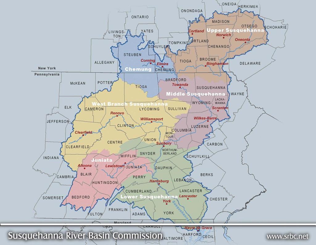

2 Susquehanna River Basin

3 REGULATED WATER USE

4 CONSTANT-RATE AQUIFER TESTING Prerequisite for groundwater withdrawal applications Must be conducted in accordance with a preapproved plan Results submitted with the groundwater withdrawal application o Determine the sustainable yield of the well o Evaluate the aquifer o Demonstrate that the requested withdrawal will not cause adverse impacts to other users and the environment Successful completion of an approved aquifer test does not guarantee an approval of the requested withdrawal
 Copies available on our website (www.srbc.")
5 AQUIFER TESTING GUIDANCE An aquifer test plan should be developed in accordance with the SRBC Aquifer Testing Guidance (Policy No ) Copies available on our website ( under the Policies, Guidance & Regulations tab


6 APPROVABLE AQUIFER TESTING PLAN COMPONENTS Background Information Hydrogeologic Description Groundwater Availability Analysis Aquifer Test Procedures Aquifer Testing Monitoring Network


7 HYDROGEOLOGIC DESCRIPTION Geologic formations Aquifer characteristics Dominant type(s) of permeability Structural data Hydrogeologic boundaries

8 CONSTRUCTION & HYDROGEOLOGIC WELL LOG Good! Bad!


9 TOPOGRAPHIC MAP(S) Contributing Geology Estimated Area of Influence Groundwater Contours Potential Recharge Boundaries Proposed Monitoring Network Proposed Discharge Location Hydrogeologic Cross Sections
10 HYDROGEOLOGIC CROSS SECTIONS Good!
")
11 HYDROGEOLOGIC CROSS SECTIONS (CONT D) Bad!
12 GROUNDWATER AVAILABILITY ANALYSIS Geologic Formation Map Symbol Age Rock Type Recharge Area (mi 2 ) 1-in-2 Recharge Rate (mgd/mi 2 ) 1-in-10 Recharge Rate (mgd/mi 2 ) 1-in-10 Recharge (mgd) Annville Fm Oan Ordovician High-calcium limestone Cocalico Fm Oco Ordovician Shale, Siltstone, Argillaceous Sandstone Epler Fm Oe Ordovician Limestone, Dolomite Hershey and Myerstown Fm, undivided Ohm Ordovician Argillaceous limestone, Limestone New Oxford conglomerate Trnc Triassic Quartz conglomerate New Oxford Fm Trn Triassic Arkosic sandstone, Shale, Mudstone, Sandstone Stonehenge Fm Os Ordovician Limestone, Conglomeratic siliceous limestone Total Recharge Area = 6.17 Total 1-in-10 Recharge = 2.51 mgd = million gallons per day mi 2 = square mile mgd/mi 2 = million gallons per day per square mile
13 GROUNDWATER AVAILABILITY ANALYSIS (CONT D) Line Recharge Area Water Budget Total (mgd) 1 Groundwater Recharge (1-in-10 yr) Groundwater Withdrawals Groundwater Availability Proposed Withdrawal Remaining Groundwater Percent Utilization of 1-in-10-year Drought Recharge [(Line 5/Line 3) x 100] 6.1%


14 AQUIFER TESTING PROCEDURES Anticipated Schedule o Step Test o Background Monitoring o 72-hr Constant Rate Pumping o Recovery Monitoring Equipment, valving, and metering o Pump setting o Flow controls o Check valve
 Monitoring Network")


15 AQUIFER TESTING PROCEDURES (CONT D) Monitoring Network o Locations and rational o Monitoring devices o Parameters to be collected o Frequency Precipitation Discharge Location


16 Groundwater Monitoring Points MONITORING NETWORK Surface Water Monitoring Points
17 SRBC REVIEW & APPROVAL Submit two hard copies and electronic version on CD o Must include payment for Aquifer Test Plan Evaluation Fee Reviewed in the order it was received The processing time significantly reduced if the plan meets SRBC standards in the first submission Receive approval before initiating test Unless otherwise specified, SRBC approval of an aquifer testing plan is valid for two years from the date of approval

18 SUMMARY Prerequisite for groundwater withdrawal applications Results used to determine the sustainable yield of the well, evaluate the aquifer, and demonstrate that the requested withdrawal will not cause adverse impacts to other users and the environment An aquifer test plan must be reviewed and approved by SRBC staff before a project sponsor undertakes the testing The processing time for the a proposed aquifer test plan can be significantly reduced the plan meets SRBC standards in the first submission Follow the SRBC Aquifer Testing Guidance (Policy No , Dec 5, 2007)

19 Developing a Technically Sound Aquifer Test Plan that Meets the Requirements of the Susquehanna River Basin Commission Presenter: Brooks G. Abeln, P.G. Hydrogeologist Susquehanna River Basin Commission Special thanks to SRBC staff for site photography: Project Review Program Staff
RESPONSIBLE PLANNING FOR FUTURE GROUND WATER USE FROM THE GREAT FLATS AQUIFER : TWO CASE STUDIES: THE GEP ENERGY
 RESPONSIBLE PLANNING FOR FUTURE GROUND WATER USE FROM THE GREAT FLATS AQUIFER : TWO CASE STUDIES: THE GEP ENERGY Introduction PROJECT AND THE SI GREEN FUELS BOILER PROJECT Thomas M. Johnson Hydrogeologist,
An Overview of the Hydrology of Adams County, PA
 An Overview of the Hydrology of Adams County, PA G. Patrick Bowling, P.G. Source Water Protection Coordinator PA DEP Bureau of Safe Drinking Water Division of Permits Source Protection & Allocations Section
DEVELOPMENT OF AQUIFER TESTING PLANS. Brent Bauman, P.G. / Erin Lynam, Aquatic Biologist
 DEVELOPMENT OF AQUIFER TESTING PLANS Brent Bauman, P.G. / Erin Lynam, Aquatic Biologist DEVELOPMENT OF AQUIFER TESTING PLANS Goals of Aquifer Testing What questions are we trying to answer Staff review
Georgia s Aquifers. USGS Fact Sheet
 Georgia s Aquifers USGS Fact Sheet 2006-3077 1 2005 Groundwater Use by Aquifer Withdrawal (mgd) 700 600 500 400 300 200 100 0 55.4% 17.5% 7.6% 6.0% 9.2% 4.3% 60% 50% 40% 30% 20% 10% 0% Percent of Withdrawal
NORTHERN LANCASTER COUNTY GROUNDWATER STUDY: A RESOURCE EVALUATION OF THE MANHEIM LITITZ
 NORTHERN LANCASTER COUNTY GROUNDWATER STUDY: A RESOURCE EVALUATION OF THE MANHEIM LITITZ AND EPHRATA AREA GROUNDWATER BASINS Publication No. 235 September 21, 2005 Robert E. Edwards, P.G. Special Projects
Natural Gas Development in the Susquehanna River Basin. Jennifer Hoffman September 29, 2010 Pittsburgh, PA
 Natural Gas Development in the Susquehanna River Basin Jennifer Hoffman September 29, 2010 Pittsburgh, PA Susquehanna River Basin The Basin 27,510-square-mile watershed Comprises 43 percent of the Chesapeake
The Corning Primary Aquifer -One of 18. NYSDEC Primary Aquifers in New York
 The Corning Primary Aquifer -One of 18 NYSDEC Primary Aquifers in New York NYSDEC Primary and Principal Aquifers PRIMARY AQUIFERS (18) Highly productive aquifers presently being utilized by major municipal
National Strategy for the Assessment of Water Availability and Use in the United States
 Philippine National Workshop Water Availability Enhancement (WAVE) Project March 1-4, 2011 National Strategy for the Assessment of Water Availability and Use in the United States Kevin F. Dennehy Reston,
Susquehanna River Basin Commission
 Susquehanna River Basin Commission a water management agency serving the Susquehanna River Watershed Policy No. 2003-03 October 9, 2003 EMERGENCY WATER WITHDRAWAL/CONSUMPTIVE USE PROCEDURES Background.
AQUIFER TEST IMPLEMENTATION BILL MILLER, P.G. SUSQUEHANNA RIVER BASIN COMMISSION
 AQUIFER TEST IMPLEMENTATION BILL MILLER, P.G. SUSQUEHANNA RIVER BASIN COMMISSION AQUIFER TEST IMPLEMENTATION Once your Aquifer Test Plan is approved Usually two years to complete the aquifer test The majority
ENVIRONMENTAL HYDROGEOLOGY
 ENVIRONMENTAL HYDROGEOLOGY m LEWIS Mostafa M. Soliman Professor, Faculty of Engineering Ain Shams University Cairo, Egypt Philip E. LaMoreaux Senior Hydrogeologist Bashir A. Memon Executive Vice President
Safe Drinking Water Program. Public Water System Permitting
 Safe Drinking Water Program Public Water System Permitting NC Region DEP Regions in Susquehanna Basin PA Safe Drinking Water Program The Safe Drinking Water Program implements the 1984 Safe Drinking Water
OVERVIEW. Report Summary CUMULATIVE WATER USE AND AVAILABILITY STUDY. for the Susquehanna River Basin
 No. 303 August 2016 Report Summary CUMULATIVE WATER USE AND AVAILABILITY STUDY for the Susquehanna River Basin OVERVIEW The Cumulative Water Use and Availability Study (CWUAS) represents the Susquehanna
Aquifer Science Staff, January 2007
 Guidelines for Hydrogeologic Reports and Aquifer Tests Conducted Within the Jurisdictional Boundaries of the Barton Springs / Edwards Aquifer Conservation District I. Introduction Aquifer Science Staff,
Groundwater in Bayfield County. Madeline Gotkowitz Hydrogeologist April 23, 2015
 Groundwater in Bayfield County Madeline Gotowitz Hydrogeologist April 23, 2015 Groundwater in Bayfield County Groundwater basics Hydrogeology across Wisconsin Hydrogeology in Bayfield County Mapping groundwater
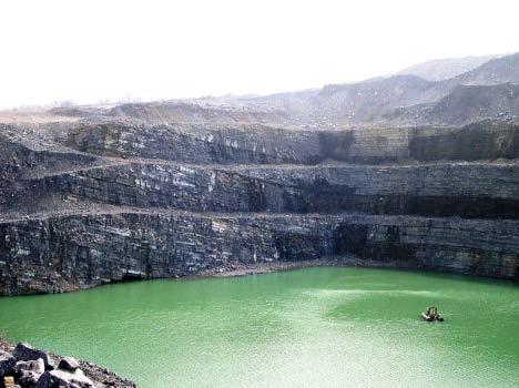
Oversized quarry sumps can be used to store run-off during
 Oversized quarry sumps can be used to store run-off during large events Paved quarry yard with channels routing run-off to attenuation 3 The Hydrogeology of Quarry Dewatering Extraction below the water
INSTRUCTIONS FOR FILING A WATER ALLOCATION PERMIT APPLICATION
 STATE OF DELAWARE DEPARTMENT OF NATURAL RESOURCES & ENVIRONMENTAL CONTROL DIVISION OF WATER RESOURCES 89 KINGS HIGHWAY DOVER, DELAWARE 19901 INSTRUCTIONS FOR FILING A WATER ALLOCATION PERMIT APPLICATION
Municipal Groundwater Flow Modelling Study. Town of Torbay, NL
 Municipal Groundwater Flow Modelling Study Town of Torbay, NL October 19, 2015 Agenda 1 Purpose 2 What is a Groundwater Model 3 Approach 4 Conceptual Model & GW Flow Model Construction 5 Model Predictions
Overview of the Draft 2010 Water Supply Assessment Report. Suwannee River Water Management District
 Overview of the Draft 2010 Water Supply Assessment Report Suwannee River Water Management District Elements of the Water Supply Assessment SRWMD 2010 Water Supply Assessment Statutory Requirements Water
Hydrologic Basis for SLVWD Drought Management Plan presented to SLVWD Board of Directors March 6, 2014
 Hydrologic Basis for SLVWD Drought Management Plan presented to SLVWD Board of Directors March 6, 2014 by Nicholas M. Johnson, Ph.D., P.G., C.Hg. Principal Hydrogeologist, MWH SLVWD Service Areas SLVWD
Environment and Natural Resources Trust Fund 2010 Request for Proposals (RFP)
") LCCMR ID: 004-A1 Project Title: Environment and Natural Resources Trust Fund 2010 Request for Proposals (RFP) Next Generation in Water Supply Management-Pilot Studies LCCMR 2010 Funding Priority: A. Water
LCCMR ID: 004-A1 Project Title: Environment and Natural Resources Trust Fund 2010 Request for Proposals (RFP) Next Generation in Water Supply Management-Pilot Studies LCCMR 2010 Funding Priority: A. Water
Groundwater Resources Program Regional Groundwater Evaluation
 Groundwater Resources Program Regional Groundwater Evaluation Appalachian Plateaus Aquifer System Kurt McCoy, David Nelms Mark Kozar Richard Yager David Ladd USGS Virginia Water Science Center USGS West
Rick Henderson, Field Operations Supervisor DEQ Office of Oil, Gas, and Minerals
 Rick Henderson, Field Operations Supervisor DEQ Office of Oil, Gas, and Minerals 1 Contamination Conservation Uses Remediation Protection Groundwater Protection DEQ Supervisor of Wells Part 615 Oil and
Numerical Modeling of Groundwater Flow in Karst Aquifer, Makeng Mining Area
 American Journal of Environmental Sciences 6 (1): 78-82, 2010 ISSN 1553-345X 2010 Science Publications Numerical Modeling of Groundwater Flow in Karst Aquifer, Makeng Mining Area 1,2 F.M. Rani and 1 Z.H.
SURFACE WATER WITHDRAWALS & LOW FLOW PROTECTION POLICY MICHAEL COLLEGE, P.E. SUSQUEHANNA RIVER BASIN COMMISSION
 SURFACE WATER WITHDRAWALS & LOW FLOW PROTECTION POLICY MICHAEL COLLEGE, P.E. SUSQUEHANNA RIVER BASIN COMMISSION SCENARIOS Direct withdrawal from surface water (SW): PA MOU w/padep NY MOU w/nysdec MD No
Supplemental Guide II-Delineations
 Supplemental Guide II-Delineations Contents Source Water Protection Area Delineation... 1 Delineation Criteria for Systems Using Groundwater Sources... 2 Time of Travel... 4 Flow Boundaries... 4 Delineation
Predicting Groundwater Sustainability: What Tools, Models and Data are Available?
 Predicting Groundwater Sustainability: What Tools, Models and Data are Available? Ray Wuolo Barr Engineering Company Assessing Sustainability is All About: Predicting (or describing) how potentiometric
Planning for Future Water Supply Needs. Brandon Kernen NH Department of Environmental Services
 Planning for Future Water Supply Needs Brandon Kernen NH Department of Environmental Services Brandon.Kernen@des.nh.gov & 603 271-0660 Objectives 1)Legal Considerations 2)Methods to Assess Future Water
Aquifer Characterization and Drought Assessment Ocheyedan River Alluvial Aquifer
 Aquifer Characterization and Drought Assessment Ocheyedan River Alluvial Aquifer Iowa Geological Survey Water Resources Investigation Report 10 Aquifer Characterization and Drought Assessment Ocheyedan
NATURAL FEATURES, LAND SUITABILITY FOR DEVELOPMENT AND DEVELOPMENT CONCERNS
 East Central Wayne County Comprehensive Plan - Natural Features, Land Suitability Page 170 NATURAL FEATURES, LAND SUITABILITY FOR DEVELOPMENT AND DEVELOPMENT CONCERNS Introduction The residents of East
MEMORANDUM. RAI Responses Related to East Lake Road Wellfield Drawdown Analysis, WUP No SDI Project No. PCF-180.
 SDI Environmental Services, Inc. 13911 N. Dale Mabry Hwy. Suite 201, Tampa, FL 33618; (813) 961-1935 MEMORANDUM TO: FROM: SUBJECT: Dave Slonena, P.G., Pinellas County Cathleen Beaudoin Jonas RAI Responses
STATE COLLEGE BOROUGH WATER AUTHORITY LAND DEVELOPMENT LEGAL AUTHORITY. Robert Mix, Esq. Authority Solicitor Lee, Green & Reiter, Inc.
 STATE COLLEGE BOROUGH WATER AUTHORITY LAND DEVELOPMENT LEGAL AUTHORITY Robert Mix, Esq. Authority Solicitor Lee, Green & Reiter, Inc. STATE COLLEGE BOROUGH WATER AUTHORITY SYSTEM OVERVIEW Brian Heiser
Groundwater Occurrence & Movement:
 Groundwater Occurrence & Movement: An Introductory Discussion with Application to East-Central Illinois East-Central Illinois Regional Water Supply Planning Committee July 27, 2007 Allen Wehrmann, P.E.,
Hydrogeology of Prince Edward Island
 Hydrogeology of Prince Edward Island General Characteristics and Groundwater on Prince Edward Island General Characteristics and Key Issues Issues PEI Dept. of Environment, Energy and Forestry 9/29/2009
Toward a Basin-Wide Drought Planning Tool in the Susquehanna River Basin
 Toward a Basin-Wide Drought Planning Tool in the Susquehanna River Basin 2016 AWRA Annual Conference November 13, 2016 Drought planning for water supply and forecasting drought conditions Josh Weiss, PhD,
Supplemental Environmental Impact Statement for the Springfield Supplemental Water Supply Project. August 24, 2016
 Supplemental Environmental Impact Statement for the Springfield Supplemental Water Supply Project August 24, 2016 What is a Supplemental Environmental Impact Statement? What is a Supplemental Environmental
GROUNDWATER DISCHARGE
 GROUNDWATER DISCHARGE C O N N E C T I O N F A C T S H E E T S E R I E S D I S C H A R G E : The movement of groundwater from the subsurface to the surface P E R M E A B I L I T Y : The ability of a material
Groundwater Management
 esm226 Norm Brown, Winter 2018 Mon & Weds 9:30-10:45a, BH 1424 Readings Groundwater Management Syllabus Administrative Items We will incorporate readings from the scientific community, data summaries,
PUBLIC POLICY FORUM February 22, 2005
 SOUTHEASTERN WISCONSIN WATER SUPPLY ISSUES AND REGIONAL WATER SUPPLY PLANNING PROGRAM OVERVIEW Presentation for PUBLIC POLICY FORUM February 22, 2005 SOUTHEASTERN WISCONSIN WATER SUPPLY ISSUES AND REGIONAL
Landscapes & Industries
 K N O W L E D G E Landscapes & Industries Groundwater Flow Systems Framework ESSENTIAL TOOLS FOR PLANNING SALINITY MANAGEMENT Summary Report Glen Walker, Mat Gilfedder, Ray Evans, Phil Dyson & Mirko Stauffacher
Rainwater Harvesting for Enhanced Groundwater Recharge Through Capture of Increased Runoff from Site Development
 Southern Illinois University Carbondale OpenSIUC 2006 Conference Proceedings 7-18-2006 Rainwater Harvesting for Enhanced Groundwater Recharge Through Capture of Increased Runoff from Site Development Mark
OUTLINE OF PRESENTATION
 GROUNDWATER?? OUTLINE OF PRESENTATION What is groundwater? Geologic investigation Definitions: aquifer and aquitard, unconfined and semi-confined Water level and interpretation of water level data Well
GROUNDWATER BASICS SUBJECTS: TIME: MATERIALS: OBJECTIVES Math (Advanced), Science (Physics) 1 class period
, Science (Physics) 1 class period") 9-12 GROUNDWATER BASICS SUBJECTS: Math (Advanced), Science (Physics) TIME: 1 class period MATERIALS: calculator paper pencil student sheet and figures OBJECTIVES The student will do the following: 1. Compute
9-12 GROUNDWATER BASICS SUBJECTS: Math (Advanced), Science (Physics) TIME: 1 class period MATERIALS: calculator paper pencil student sheet and figures OBJECTIVES The student will do the following: 1. Compute
Understanding the Water System
 W Water Is a Natural Resource Understanding the Water System Cost WATER QUALITY in KENTUCKY The Water Cycle Figure 1. Trends in Water Withdrawals and Population, 1950 to 1995. Millions of People/Billion
Daniel R. Hadley, PG and Daniel B. Abrams, PhD
 Revisiting one of the largest aquifer tests in history: Implications for fault zone hydrogeology and the declining groundwater supply in Northeastern Illinois Daniel R. Hadley, PG and Daniel B. Abrams,
Name: Problem 1. (30 points; 5 each)
") 2700 2500 1900 2100 1500 2300 1800 1700 Hydrogeology - HWR/GEOS 431/531 Final exam Dr. Marek Zreda 16 December 1998 11:00-1:00 Open books and notes There are 5 problems on 7 pages. Read entire test before
2700 2500 1900 2100 1500 2300 1800 1700 Hydrogeology - HWR/GEOS 431/531 Final exam Dr. Marek Zreda 16 December 1998 11:00-1:00 Open books and notes There are 5 problems on 7 pages. Read entire test before
Appendix F Offset Project
 Appendix F Offset Project Geology, Soil and Water Information Project area geology (Hardeman et. al. 1966) is presented in Table 1, below. Geologic Map Symbol Table F1: Offset Project Area Geology Geologic
Managed Aquifer Recharge (MAR) Practical Techniques for the Caribbean
 Practical Techniques for the Caribbean") Managed Aquifer Recharge (MAR) Practical Techniques for the Caribbean Scope of Presentation What is MAR? Antigua and Barbuda water resources issues Why promote MAR? MAR: Techniques MAR: Design criteria
Managed Aquifer Recharge (MAR) Practical Techniques for the Caribbean Scope of Presentation What is MAR? Antigua and Barbuda water resources issues Why promote MAR? MAR: Techniques MAR: Design criteria
ALABAMA GROUNDWATER SUSTAINABILITY: A STRONG SCIENTIFIC FOUNDATION FOR WATER RESOURCE MANAGEMENT AND POLICY TO SECURE ALABAMA S WATER FUTURE
 ALABAMA GROUNDWATER SUSTAINABILITY: A STRONG SCIENTIFIC FOUNDATION FOR WATER RESOURCE MANAGEMENT AND POLICY TO SECURE ALABAMA S WATER FUTURE Marlon Cook Geological Survey of Alabama Groundwater Assessment
VARIANCE REQUEST FOR EXPANDED WATER USE FROM EXISTING WELL IN A STAY MANAGEMENT AREA OF THE LOWER PLATTE NORTH NRD (LPNNRD)
") VARIANCE REQUEST FOR EXPANDED WATER USE FROM EXISTING WELL IN A STAY MANAGEMENT AREA OF THE LOWER PLATTE NORTH NRD (LPNNRD) Updated Form: August 2012 NRD USE ONLY Date Received Paid: Cash or Check Initial
VARIANCE REQUEST FOR EXPANDED WATER USE FROM EXISTING WELL IN A STAY MANAGEMENT AREA OF THE LOWER PLATTE NORTH NRD (LPNNRD) Updated Form: August 2012 NRD USE ONLY Date Received Paid: Cash or Check Initial
Guidelines for Preparing an Alternatives Analysis
 Policy Number: Policy No. 2017-01 Title: Guidelines for Preparing an Alternatives Analysis Effective Date: September 7, 2017 Authority: Policy: Public Law 91-575, 84 Stat. 1509 et seq., Sections 3.1, 3.4(2),
Groundwater in the Santa Rosa Plain
 . Groundwater in the Santa Rosa Plain Marcus Trotta, PG, CHg Principal Hydrogeologist Sonoma County Water Agency Santa Rosa Plain Groundwater Sustainability Agency October 12, 2017 www.sonomacountywater.org
Environmental Protection in the Development of the Marcellus Shale
 Environmental Protection in the Development of the Marcellus Shale Areas of Environmental Protection Water sources Site development Wetland and waterway protection Water quality protection Dams and impoundments
USGS Groundwater Resources Program Regional Groundwater Evaluations
 USGS Groundwater Resources Program Regional Groundwater Evaluations -- Northern Atlantic Coastal Plain Aquifer System -- John Masterson* New England Water Science Center Northborough, Massachusetts Delaware
Hydrogeology Laboratory Semester Project: Hydrogeologic Assessment for CenTex Water Supply, Inc.
 Hydrogeology Laboratory Semester Project: Hydrogeologic Assessment for CenTex Water Supply, Inc. Matthew M. Uliana, Ph.D. Department of Biology Geology Program and Aquatic Resources Texas State University
3.0 MANAGEMENT ISSUES AND RECOMMENDATIONS
 3.0 MANAGEMENT ISSUES AND RECOMMENDATIONS The purpose of this section is to describe some of the policies and issues related to the management of groundwater resources and identify recommended actions.
University of Arizona Department of Hydrology and Water Resources Dr. Marek Zreda. HWR431/531 - Hydrogeology Problem set #1 9 September 1998
 University of Arizona Department of Hydrology and Water Resources Dr. Marek Zreda HWR431/531 - Hydrogeology Problem set #1 9 September 1998 Problem 1. Read: Chapter 1 in Freeze & Cherry, 1979. McGuiness
WATER SUPPLY ISSUES IN SOUTHEASTERN WISCONSIN: TECHNICAL AND POLICY NEEDS AND CHALLENGES
 WATER SUPPLY ISSUES IN SOUTHEASTERN WISCONSIN: TECHNICAL AND POLICY NEEDS AND CHALLENGES Presentation for Conference STRADDLING THE DIVIDE WATER SUPPLY PLANNING IN THE LAKE MICHIGAN REGION February 15-16,
Appendix E Pump Test Report
 Appendix E Pump Test Report GROUND-WATER EXPLORATION PROGRAM LEGACY RIDGE, TOWN OF WOODBURY, NEW YORK Prepared For: Legacy Ridge August 2007 Prepared By: LEGGETTE, BRASHEARS & GRAHAM, INC. Professional
DEFINITION OF TERMS AND ACRONYMS 31 TAC EFFECTIVE DECEMBER 8, 2016
 DEFINITION OF TERMS AND ACRONYMS 31 TAC 357.10 EFFECTIVE DECEMBER 8, 2016 The terms and acronyms used in this guidance document as defined in 31 TAC 357.10 have the following meanings: 1. Agricultural
Fundamental of Groundwater Hydrology. Ted Way
 Fundamental of Groundwater Hydrology Ted Way Outline Hydrologic cycle Aquifers Basic groundwater equations Well drilling and completion Groundwater level and velocity Definition of key hydrologic parameters
EGYPT PLAN FOR LAND RECLAMATION DURING THE COMING 4 YEARS
 EGYPT PLAN FOR LAND RECLAMATION DURING THE COMING 4 YEARS PREFACE Egypt water resources are limited to the Nile water, which is heavily utilized along the Nile Valley and within the Nile Delta. After the
Groundwater Levels and Pumpage in the East St. Louis Area, Illinois,
 Circular 112 STATE OF ILLINOIS DEPARTMENT OF REGISTRATION AND EDUCATION Groundwater Levels and Pumpage in the East St. Louis Area, Illinois, 1967-1971 by W. H. BAKER, JR. ILLINOIS STATE WATER SURVEY URBANA
Corrective Action Cost Estimate for Known or Reasonably Foreseeable Release to Water For Lopez Canyon Landfill By The City of Los Angeles Bureau of
 Corrective Action Cost Estimate for Known or Reasonably Foreseeable Release to Water For Lopez Canyon Landfill By The City of Los Angeles Bureau of Sanitation Solid Resource Processing and Construction
The SADC Hydrogeological Map & Atlas: Towards an improved understanding of groundwater regimes in Southern Africa
 The SADC Hydrogeological Map & Atlas: Towards an improved understanding of groundwater regimes in Southern Africa K. Pietersen 1, N. Kellgren 2, O. Katai 3 and M. Roos 4 (1) Water Geosciences Consulting,
Wells To ensure a continuous supply of water, a well must penetrate below the water table. Pumping of wells can cause:
 Wells To ensure a continuous supply of water, a well must penetrate below the water table. Pumping of wells can cause: Drawdown (lowering) of the water table Cone of depression in the water table Cone
AQUIFER TESTING WAIVER REQUESTS. Brent Bauman, P.G.
 AQUIFER TESTING WAIVER REQUESTS Brent Bauman, P.G. AQUIFER TESTING WAIVER REQUESTS A project sponsor may request a waiver of any requirement, provided the request and explanation is made in writing at
Stream hydrographs. Stream hydrographs. Baseflow. Graphs of river stage or discharge at a single location as a function of time
 Stream hydrographs Graphs of river stage or discharge at a single location as a function of time Hydrologic og budget Discharge: units? How is it measured? Show fluctuating water levels in response to
Hydrogeology 101 3/7/2011
 Hydrogeology 101 W. Richard Laton, Ph.D., PG, CPG Associate Professor of Hydrogeology California State University, Fullerton Department of Geological Sciences 1 Hydrogeology 101 The objective is to obtain
Aquifer Storage and Recovery (ASR) Implementation and Operations in a Water System. Tiffanie Hawley, CFPUA Randy Plummer, HDR
 Implementation and Operations in a Water System. Tiffanie Hawley, CFPUA Randy Plummer, HDR") Aquifer Storage and Recovery (ASR) Implementation and Operations in a Water System Tiffanie Hawley, CFPUA Randy Plummer, HDR NC AWWA Spring Conference 2014 Background Data CFPUA Water System Fear Public
Aquifer Storage and Recovery (ASR) Implementation and Operations in a Water System Tiffanie Hawley, CFPUA Randy Plummer, HDR NC AWWA Spring Conference 2014 Background Data CFPUA Water System Fear Public
LAKE LABELLE DEWATERING MODEL. AUTHOR Gail Murray Doyle, P.G. September Murray Consultants, Inc 769 Skyview Dr Hayesville, NC
 LAKE LABELLE DEWATERING MODEL AUTHOR Gail Murray Doyle, P.G. September 2013 Murray Consultants, Inc 769 Skyview Dr Hayesville, NC 28904 828-389-2476 LAKE LABELLE DEWATERING MODEL INTRODUCTION Purpose The
Irrigation modeling in Prairie Ronde Township, Kalamazoo County. SW Michigan Water Resources Council meeting May 15, 2012
 Irrigation modeling in Prairie Ronde Township, Kalamazoo County SW Michigan Water Resources Council meeting May 15, 2012 Development of a Groundwater Flow Model INFLOWS Areal recharge from precipitation
Groundwater. Groundwater Movement. Groundwater Movement Recharge: the infiltration of water into any subsurface formation.
 On March 22, 2014, a major landslide occurred near Oso, Washington. Death toll currently at 30, with 15 still missing. Groundwater Before and After Swipe http://bit.ly/pen1jt N. Fork Stillaguamish River
Numerical Modeling of Groundwater Flow in the Navajo Sandstone Aquifer at the Tuba City, Arizona, Disposal Site 15167
 Numerical Modeling of Groundwater Flow in the Navajo Sandstone Aquifer at the Tuba City, Arizona, Disposal Site 15167 ABSTRACT Richard Bush*, Timothy Bartlett** *US DOE, Office of Legacy Management **Stoller
Annual Groundwater Monitoring Interpretative Report-2016 Issued to the Environmental Protection Agency (2016) (PO386-03
 (PO386-03") LICENCE REFERENCE No. RISK ASSESSMENT METHODOLOGY STAGE & STEP ANNUAL INTERPRETATIVE REPORT REPORT VERSION FINAL Annual Groundwater Monitoring Interpretative Report-2016 Issued to the Environmental Protection
LICENCE REFERENCE No. RISK ASSESSMENT METHODOLOGY STAGE & STEP ANNUAL INTERPRETATIVE REPORT REPORT VERSION FINAL Annual Groundwater Monitoring Interpretative Report-2016 Issued to the Environmental Protection
Groundwater Level and Movement
 Groundwater Level and Movement Infiltration and Recharge Infiltration Entry of rain water into the ground. Recharge Addition of infiltrated water to the aquifer. Two types of Recharge- 1. Natural 2. Artificial
RIDDICK ASSOCIATES, P.C.
 RIDDICK ASSOCIATES, P.C. CIVIL & ENVIRONMENTAL ENGINEERS 139 LAFAYETTE AVENUE SUFFERN, NEW YORK 10901 845 357-7238 FAX 845 357-7267 NORMAN L. LINDSAY DENNIS G. LINDSAY ---------------------------- SEAN
The Ground Water Supply of Southeastern Wisconsin (Will there be enough for the future?)
") The Ground Water Supply of Southeastern Wisconsin (Will there be enough for the future?) Douglas Cherkauer Professor of Hydrogeology Department of Geosciences University of Wisconsin-Milwaukee Topics to
The Ground Water Supply of Southeastern Wisconsin (Will there be enough for the future?) Douglas Cherkauer Professor of Hydrogeology Department of Geosciences University of Wisconsin-Milwaukee Topics to
Division Mandates. Supervise the drilling, operation, and maintenance of wells to prevent damage to life, health, property, and natural resources.
 Division Mandates Supervise the drilling, operation, and maintenance of wells to prevent damage to life, health, property, and natural resources. Supervise and permit the owners/operators to utilize all
SUITABILITY FOR IN-SITU RECOVERY (ISR) CONFIRMED
 CONFIRMED") 8 September 2008 Companies Announcement Office Via Electronic Lodgement SUITABILITY FOR IN-SITU RECOVERY (ISR) CONFIRMED Independent review of historical data has confirmed that the Lance Project is suitable
8 September 2008 Companies Announcement Office Via Electronic Lodgement SUITABILITY FOR IN-SITU RECOVERY (ISR) CONFIRMED Independent review of historical data has confirmed that the Lance Project is suitable
GROUNDWATER POTENTIAL OF THE THIKA AREA, KENYA
 GROUNDWATER POTENTIAL OF THE THIKA AREA, KENYA SGL 413:PROJECT IN GEOLOGY Presented by: Muraguri Peter Njuguna Reg No. L13/21429/2008 Contents Study area Objectives Geology of the study area Hydrogeology
STRAWMAN OUTLINE March 21, 2008 ISWS/ISGS REPORT ON THE OPPORTUNITIES AND CHALLENGES OF MEETING WATER DEMAND IN NORTH-EAST ILLINOIS
 STRAWMAN OUTLINE March 21, 2008 ISWS/ISGS REPORT ON THE OPPORTUNITIES AND CHALLENGES OF MEETING WATER DEMAND IN NORTH-EAST ILLINOIS REPORT TO BE DELIVERED TO THE RWSPG BY SEPTEMBER 30, 2008 Table of Contents
Barnes & Tucker Project
 West Branch Susquehanna Restoration Symposium April 27-28, 2007 Barnes & Tucker Project Daniel Sammarco,P.E. Jon Smoyer, P.G. DEP-Bureau of Abandoned Mine Reclamation Cambria Office Dsammarco@state.pa.us
WATER RESOURCES SUSTAINABILITY AND HOW IT IS IMPLEMENTED IN THE STATE OF KANSAS, USA
 WATER RESOURCES SUSTAINABILITY AND HOW IT IS IMPLEMENTED IN THE STATE OF KANSAS, USA Marios Sophocleous Kansas Geological Survey The University of Kansas Lawrence, Kansas E-mail: marios@kgs.ku.edu SUSTAINABLE
8. Regional groundwater system
 8. Regional groundwater system 8-1 We have learned basic principles governing the flow and storage of groundwater. We will now use these principles to understand groundwater in the regional context. Flow
Numerical Groundwater Model for the Kaweah Delta Water Conservation District
 Numerical Groundwater Model for the Kaweah Delta Water Conservation District Nels Ruud and Peter Leffler Fugro West, Inc. Larry Dotson Kaweah Delta Water Conservation District Presentation Outline Background
Using Treated AMD for Frack Water the Antrim Experience
 Using Treated AMD for Frack Water the Antrim Experience Antrim No. 1 Mine Discharge The Babb Creek Watershed Antrim Treatment Plant Babb Creek Location Babb Creek Wilson Creek SWP 09A Pabnd.shp 90 0 90
Overview of Water Resources (Part 2): Groundwater in Sonoma Valley
: Groundwater in Sonoma Valley") . Overview of Water Resources (Part 2): Groundwater in Sonoma Valley Marcus Trotta, PG, CHg Principal Hydrogeologist Sonoma County Water Agency Sonoma Valley Groundwater Sustainability Agency October 23,
. Overview of Water Resources (Part 2): Groundwater in Sonoma Valley Marcus Trotta, PG, CHg Principal Hydrogeologist Sonoma County Water Agency Sonoma Valley Groundwater Sustainability Agency October 23,
7. Are all the wells used in the contour map screened in the same water-bearing zone? Yes X No. If no, justify inclusion of those wells.
 Hoffmann-La Roche Inc. - Nutley, New Jersey Building 716 (B716) Gauging Event - Zone S1 All Roche-owned wells have been surveyed. All available well documents (including the surveyor Form Bs) are provided
Groundwater basics. Groundwater and surface water: a single resource. Pore Spaces. Simplified View
 Groundwater and surface water: a single resource Santa Cruz River, Tucson Groundwater basics Groundwater is water found within the pore spaces of geologic material beneath the surface of the Earth. It
Investigation of a Floodplain Pond to Improve Alluvial Aquifer Sustainability: A Quantity and Quality Report
 Investigation of a Floodplain Pond to Improve Alluvial Aquifer Sustainability: A Quantity and Quality Report Water Resources Investigation Report 16 i P a g e Investigation of a Floodplain Pond to Improve
Master of Science Practical Exam. Climate and Hydrology of Big Spring Creek, Cumberland County, Pennsylvania
 Master of Science Practical Exam Climate and Hydrology of Big Spring Creek, Cumberland County, Pennsylvania Laurie Young Revised January 27,212- February 3,212 For: Dr. Woltemade Dr. Feeney Table of Contents
What is Long-Term Sustainable Well Yield and how should we calculate it using the Modified Moell Method? Joel Defoe EnviroTech 2018 April 5, 2018
 What is Long-Term Sustainable Well Yield and how should we calculate it using the Modified Moell Method? Joel Defoe EnviroTech 2018 April 5, 2018 Alberta Regulatory Environment Alberta Environment and
A HYDROLOGIST S PERSPECTIVE ON DEEP SALINE WATER EXPLORATION by Casey W. Cook Balleau Groundwater, Inc.
 A HYDROLOGIST S PERSPECTIVE ON DEEP SALINE WATER EXPLORATION by Casey W. Cook Balleau Groundwater, Inc. Introduction Deep, non-potable water is defined in New Mexico as: an aquifer, the top of which aquifer
Chapter 1 Introduction
 Engineering Hydrology Chapter 1 Introduction 2016-2017 Hydrologic Cycle Hydrologic Cycle Processes Processes Precipitation Atmospheric water Evaporation Infiltration Surface Runoff Land Surface Soil water
Introduction to Groundwater
 Introduction to Groundwater Unit Essential Questions: How does the Earth cycle its water through its major reservoirs? How does society s use of resources affect water quality? Presentation Objectives:
WATER LEVEL CHANGES IN THE UNCONFINED AQUIFER OF THE SAN LUIS VALLEY,
 WATER LEVEL CHANGES IN THE UNCONFINED AQUIFER OF THE SAN LUIS VALLEY, 1980-1995 By Isobel R. McGowan Shepherd Miller, Inc. 2460 W. 26th Ave., Suite 430-C Denver, CO 80211 and Dan Plazak Consulting Hydrogeologist
Safe Drinking Water Program Public Water System Permitting. May 17, 2016 Derrick Havice, P.G.
 Safe Drinking Water Program Public Water System Permitting May 17, 2016 Derrick Havice, P.G. PA Safe Drinking Water Program The Safe Drinking Water Program implements the 1984 Safe Drinking Water Act The
Aquifer Mapping and Management : An Approach in Indian Perspective
 Aquifer Mapping and Management : An Approach in Indian Perspective Dr. R. C. Jain Formerly Chairman, Central Ground Water Board and Central Ground Water Authority and other footers Ground water -the backbone
COMPREHENSIVE PLAN ELIZABETH TOWNSHIP LANCASTER COUNTY, PENNSYLVANIA. September 8, 2003
 }~ š { z yx àßþý ãä ŒŽ 56789 ¾ ¹ HI ½¾ Å Ç _` MN ùú âááàßõþ ƒ ~} / > :;< =;? ÉÊËÌÍ MN PQ xyz{ Ž @ABC DEFEGEHIJKLJMNOQPRSPT UV XY WXZ[\]^_`ab 01c ?? 789:; &'(&')&*+,-./012 345 66! "#$% j kl l m no p