New Castle County, DE. Floodplain Regulations
|
|
|
- Sylvia Hunter
- 6 years ago
- Views:
Transcription
1 New Castle County, DE Floodplain Regulations John J. Gysling, PE CFM Department of Land Use New Castle County, DE February 26, 2009
2 Today s Presentation Floodplain Protection and Uses Terms and Definitions Site Design Examples Building and Floodplains
3 100% protected resource Netted out of base site area (not buildable land) UDC restricts uses in resource areas
4 Permitted: Field crops, orchards, pastures, ball fields, fishing areas, natural areas, trails
5 Limited: Nursery, golf courses, day camps, playgrounds, pools, courts (means they must comply with additional standards in Article 10)
6 Certain uses require an Environmental Impact Assessment e.g. public/private roads, bridges, essential access, fish hatchery, sewage and water treatment plants, stormwater management practices
7 EIA addresses: Site character Avoidance Minimization Mitigation Conservation Design
8 A variance may be sought from the Board of Adjustment after review by the environmental committee for any use not permitted by the UDC e.g. parking in the floodplain.
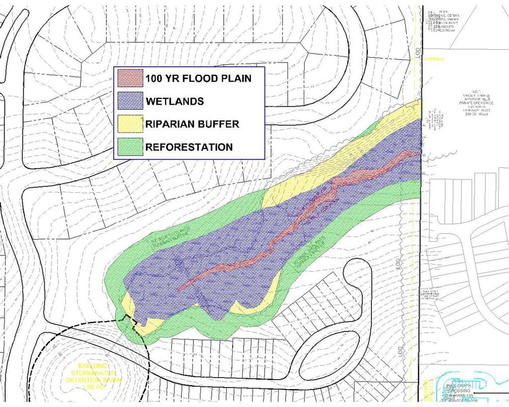
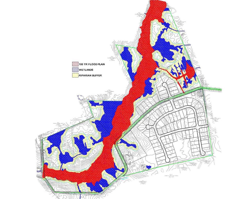
9 UDC defines floodplain, floodway, flood fringe and non-delineated floodplain. UDC requires a 50 foot minimum riparian buffer area adjacent to all floodplains and wetlands of certain size and 100 foot buffer from all streams.
10 Floodplain Flood fringe Floodway Nondelineated floodplain Riparian Buffer Areas
11 Floodplain A relatively flat or low-lying land area adjoining a river, stream or watercourse which is subject to periodic partial or complete inundation by water from any source during the base flood.

12 Stream CL Floodplain
13 Definitions Flood fringe Those portions of the Zone AE floodplain, outside of the floodway, subject to inundation by the 100 year recurrence interval flood or base flood and generally associated with standing or slowly moving water, rather than rapidly flowing water. Floodway The portion of the floodplain district required to carry and discharge the waters of the 100 year flood or base flood without increasing the water surface elevation at any point more than one (1) foot above existing conditions as demonstrated in a Flood Insurance Study.


14 Floodway and Flood Fringe Stream CL Floodfringe Floodway
15 Non-delineated floodplain Area subject to a 100 yr. flood: FEMA has not delineated a floodplain; Adjacent to a watercourse as identified by a blue line on the current USGS topographic maps of the County, Adjacent to a watercourse that is defined as a stream in the detailed maps of the NRCS NCC Soil Survey.
16 Riparian Buffer Area (RBA) An RBA consists of land which forms a transition zone between aquatic and terrestrial environments. RBA s include: 100 feet on either side of perennial or intermittent streams, lakes and tidal wetlands. All of the floodplain plus an additional 50 feet of adjacent land. All of a non-tidal wetland greater than sf in area plus and additional 50 feet of adjacent land. All of any size non-tidal wetland classified as a Piedmont Stream Valley Wetland.
17 Site Design Examples
18
19 FEMA Floodplain
20 Buildings and Floodplains
21 Permitted construction in floodplains: 1) Where approved as a Beneficial Use; 2) Replacement or substantial repair of an existing non-conforming structure.
22 Floodplain Development Permit Compliance with sections in Article 10 Beneficial Use application and Board of Adjustment hearing Typically used in coastal communities

")
23 Structure still must be elevated 18 inches above base flood elevation Applies to reconstruction and substantial repair and substantial improvement Can be expanded as long as footprint is not increased (i.e. second floor)
24 Criteria for Building in Floodplain No net fill Only areas below finished floor including basement to be used for parking, building access and storage may be wet flood proofed (one square inch per square foot) Wet flood proofing above the lowest floor is not permitted New and substantially improved non-residential buildings may be flood proofed (i.e. floodwalls and doors)
25 Criteria for Building in Floodplain (continued) All service utilities must be elevated or flood proofed in accordance with Chapter 6 of the New Castle County Code (Building Code). Any fill placed must be clean, compacted and stabilized to prevent erosion.
26 Finished floors (including basements) elevated 18 above base flood elevation No new lots within floodplain unless sufficient buildable area provided outside of the floodplain Provisions for redevelopment in floodplains for Brownfield.
27 No Adverse Impact New Castle County Perspective
28 New Castle County Drainage Code Citations (June, 1998) Conveyance System Stipulations A. Any person who engages in land disturbing activity shall control the contribution of off-site runoff through the site by adequately sizing the conveyance system. On-site runoff shall be collected and an adequate conveyance system provided to transport the runoff to an existing watercourse or pipe system of adequate capacity to accommodate the peak rate of stormwater flow for the maximum design storm of the drainage area.
29 New Castle County Drainage Code Citations (June, 1998) Conveyance Systems Stipulations (cont.) D. Conveyance systems shall outfall to a stormwater management facility or watercourse capable of accepting the design runoff.
30 New Castle County Drainage Code Citations (June, 1998) Conveyance System Stipulations (cont.) F. The drainage system shall be designed so that parcels over which the surface waters are conveyed from the development site to existing watercourses or pipe systems are not adversely affected and that the developed property may continue to discharge runoff without offsite modification
31 Delaware Sediment and Stormwater Regulations (10/11/06) It is the overall goal of the Department to utilize stormwater management as a means to minimize water quantity and water quality impacts due to land disturbing activities and to mimic pre-development hydrology, to the maximum extent practicable, in regards to the rate, volume and duration of flow.
32 Delaware Sediment and Stormwater Regulations (10/11/06) In addition to the peak flow control design criteria contained in this Section, projects in the Mill Creek, Little Mill Creek, Red and White Clay Creeks, Persimmon Creek and Shellpot Creek watersheds shall demonstrate successful management of any increase in stormwater runoff from pre-development land use conditions. Successful management of increased stormwater volume shall include but not be limited to; recharge, infiltration and re-use where soils and site are applicable. For any increase in volume that cannot be recharged, infiltrated or re-used, volume management may be achieved by modifying the release rate for the increase in volume so as not to increase the flood elevation for all storms up to and including the 100 year return period.
33 Delaware Sediment and Stormwater Regulations (10/11/06) Where ponds are the proposed method of control, the developer shall submit to the approving agency, when required, an analysis of the impacts of stormwater flows downstream in the watershed for the 100 year frequency storm event.
34 Delaware Sediment and Stormwater Regulations The Regulations are currently undergoing revision. The revisions will incorporate requirements to infiltrate the resource protection storm event (1 year storm) and further manage post-developed storm events to reduce impacts in watersheds.
NEW CASTLE CONSERVATION DISTRICT. through. (Name of Municipality) PLAN REVIEW APPLICATION DRAINAGE, STORMWATER MANAGEMENT, EROSION & SEDIMENT CONTROL
 PLAN REVIEW APPLICATION DRAINAGE, STORMWATER MANAGEMENT, EROSION & SEDIMENT CONTROL") NEW CASTLE CONSERVATION DISTRICT through (Name of Municipality) PLAN REVIEW APPLICATION DRAINAGE, STORMWATER MANAGEMENT, EROSION & SEDIMENT CONTROL Office use only: Received by Municipality: Received by
NEW CASTLE CONSERVATION DISTRICT through (Name of Municipality) PLAN REVIEW APPLICATION DRAINAGE, STORMWATER MANAGEMENT, EROSION & SEDIMENT CONTROL Office use only: Received by Municipality: Received by
CHELTENHAM TOWNSHIP Chapter 290: WATERSHED STORMWATER MANAGEMENT Article IV: Stormwater Management
 CHELTENHAM TOWNSHIP Chapter 290: WATERSHED STORMWATER MANAGEMENT Article IV: Stormwater Management Online ECode Available on Cheltenham Township Website at: http://ecode360.com/14477578 For all regulated
Municipal Stormwater Management Plan Prepared For The Borough of Cape May Point By Van Note-Harvey Associates VNH File No.
 Municipal Stormwater Management Plan Prepared For The Borough of Cape May Point By Van Note-Harvey Associates 2005 VNH File No. 35317-210-21 Table of Contents Introduction... 3 Goals... 3 Storm water Discussion...
Will County Site Development Permit Submittal Checklist TAB 1 PROJECT OVERVIEW
 Applicant: Reviewer: Permit No.: The following tables contain a checklist of the requirements before a review for a Site Development Permit submittal will be accepted. Not all requirements pertain to every
DRAINAGE AND NATURAL AQUIFER GROUNDWATER RECHARGE ELEMENT
 Goal 7.0. To optimize integrated stormwater management in order to reduce damage and impacts from sea level rise and flooding, promotes recharge to the Surficial Aquifer System (SAS), improve and protect
Chapter 105 Dam Safety and Waterway Management
 Chapter 105 Dam Safety and Waterway Management An overview PA Department of Environmental Protection Bureau of Watershed Management Division of Waterways, Wetlands, & Stormwater Management Purpose The
CHAPTER 6 ADDITIONAL STANDARDS APPLYING TO SHORELAND AREAS AND PUBLIC WATERS
 CHAPTER 6 ADDITIONAL STANDARDS APPLYING TO SHORELAND AREAS AND PUBLIC WATERS Section 1 Intent. 49 Section 2 Floodplain Requirements 49 Section 3 Water-Oriented Accessory Structures 50 Section 4 Stairways,
Stormwater Management Studies PDS Engineering Services Division ES Policy # 3-01
 Stormwater Management Studies PDS Engineering Services Division Revised Date: 2/28/08 INTRODUCTION The City of Overland Park requires submission of a stormwater management study as part of the development
ZONING ORDINANCE FOR THE ZONED UNINCORPORATED AREAS ARTICLE 1500 OF PUTNAM COUNTY, WEST VIRGINIA Page 149 ARTICLE 1500 DRAINAGE AND STORM SEWERS
 OF PUTNAM COUNTY, WEST VIRGINIA Page 149 ARTICLE 1500 DRAINAGE AND STORM SEWERS 1500.01 GENERAL REQUIREMENTS 1500.02 NATURE OF STORM WATER FACILITIES 1500.03 DRAINAGE EASEMENTS 1500.04 STORM WATER MANAGEMENT
COON CREEK WATERSHED DISTRICT PERMIT REVIEW
 16-054 Woodland Creek Wetland Banking Restoration Project, Page 1 of 6 COON CREEK WATERSHED DISTRICT PERMIT REVIEW MEETING DATE: August 22, 2016 AGENDA NUMBER: 11 FILE NUMBER: 16-054 ITEM: Woodland Creek
Phase II: Proposed (regulated) Impervious in disturbed area (ac) Long Lake Existing Impervious in disturbed area (ac)
 Impervious in disturbed area (ac) Long Lake Existing Impervious in disturbed area (ac)") Permit Application No.: 17-181 Rules: Erosion Control, Wetland Protection, and Waterbody Crossings & Structures Applicant: Hennepin County Received: 4/27/17 Project: CSAH 112 Phase II Complete: 9/5/17
Permit Application No.: 17-181 Rules: Erosion Control, Wetland Protection, and Waterbody Crossings & Structures Applicant: Hennepin County Received: 4/27/17 Project: CSAH 112 Phase II Complete: 9/5/17
Riparian Setback- What is that and what should I be doing? October 25th, 2016 Presented by: Anil Tangirala, PE, CFM, ENV SP
 Riparian Setback- What is that and what should I be doing? October 25th, 2016 Presented by: Anil Tangirala, PE, CFM, ENV SP Agenda Introduction Stream and Riparian Impacts Ohio EPA Stormwater General Permit
Municipal Stormwater Management Planning
 Municipal Stormwater Management Planning Christopher C. Obropta, Ph.D., P.E. Water Resources Extension Specialist with Rutgers Cooperative Extension Assistant Professor with Department of Environmental
KANKAKEE COUNTY PLANNING DEPARTMENT APPLICATION FOR CLASS I & II GRADING AND DRAINAGE/STOMRWATER PERMIT APPLICATION
 KANKAKEE COUNTY PLANNING DEPARTMENT APPLICATION FOR CLASS I & II GRADING AND DRAINAGE/STOMRWATER PERMIT APPLICATION Michael J. Van Mill, AICP Planning Director 189 East Court Street Kankakee, IL 60901
LAKE COUNTY HYDROLOGY DESIGN STANDARDS
 LAKE COUNTY HYDROLOGY DESIGN STANDARDS Lake County Department of Public Works Water Resources Division 255 N. Forbes Street Lakeport, CA 95453 (707)263-2341 Adopted June 22, 1999 These Standards provide
CCSD#1 Stormwater Standards
 SECTION 5 STORMWATER MANAGEMENT PLAN This Section of the Stormwater Management Design Standards describes the methods and criteria necessary to integrate infiltration, water quality, and flow control stormwater
COON CREEK WATERSHED DISTRICT PERMIT REVIEW Mississippi Dr Coon Rapids, MN SQ FT Residence on 0.64 Acre Lot
 17-082 Van Sloun Residence, Page 1 of 5 COON CREEK WATERSHED DISTRICT PERMIT REVIEW MEETING DATE: May 8, 2017 AGENDA NUMBER: 17 FILE NUMBER: 17-082 ITEM: Van Sloun Residence RECOMMENDATION: Approve with
Appendix A Stormwater Site Plan Report Short Form
 Appendix A Stormwater Site Plan Report Short Form The Stormwater Site Plan Report Short Form may be used for projects that trigger only Minimum Requirements #1-#5. These projects typically fall within
Municipal Stormwater Ordinances Summary Table
 APPENDIX F Municipal Ordinances Summary Table Municipality Abington Bryn Athyn Borough Hatboro Borough Ordinance, SALDO Runoff equals pre post Erosion Sediment Control Water Quality Requirements Any which
Chapter 5: Water Quality Buffer Requirements
 Chapter 5: Water Quality Buffer Requirements 5.1 Introduction Water quality buffer requirements apply to all new land development or redevelopment containing streams or other water bodies such as ponds,
APPENDIX N Guidance for Preparing/Reviewing CEQA Initial Studies and Environmental Impact Reports
 APPENDIX N N.1 Guidance for Preparing and Reviewing CEQA Initial Studies Step 1: Consider the Project Characteristics as Provided by the Project Applicant Review the project application and draft plan
Holly Swartz and Jason Shirey
 Chapter 105 General Permits for Stream and Wetland Impacts DEP Ch. 105 CONTACTS FOR BERKS COUNTY: Holly Swartz and Jason Shirey What DEP Regulates Under Chapter 105 Waters of the Commonwealth, which includes
Background. Literature Review
 Ms. Joanna Helms Economic Development Director Town of Apex 73 Hunter Street P.O. Box 250 Apex, North Carolina 27502 October 23, 2015 Reference: Report of Wetland Determination Cash Perkins Site ECS Project
Programmatic General Permit Army Corps of Engineers Connecticut Addendum
 Programmatic General Permit Army Corps of Engineers Connecticut Addendum DEP USE ONLY NAE#: DEP #: PGP Screening Date: Determinations: Eligible Category 2 Eligible Category 1 Individual Permit Print or
Attachment H: Engineering Documentation
 Attachment H: Engineering Documentation Part 2: Hydrologic and Hydraulic Consistency Worksheet Inland Water Resources Division Permit Activities This worksheet has four sections; only complete the section(s)
CITY OF NEW WESTMINSTER. Bylaw No. 7033, 2005 RIPARIAN AREAS PROTECTION BYLAW
 CITY OF NEW WESTMINSTER Bylaw No. 7033, 2005 RIPARIAN AREAS PROTECTION BYLAW WHEREAS the City may preserve, protect, restore and enhance the natural environment near streams that support fish habitat from
Stormwater Erosion Control & Post-Construction Plans (Stormwater Quality Plans)
") Stormwater Erosion Control & Post-Construction Plans (Stormwater Quality Plans) Allen County Stormwater Plan Submittal Checklist The following items must be provided when applying for an Allen County Stormwater
Stormwater Erosion Control & Post-Construction Plans (Stormwater Quality Plans) Allen County Stormwater Plan Submittal Checklist The following items must be provided when applying for an Allen County Stormwater
COON CREEK WATERSHED DISTRICT PERMIT REVIEW th Ave NE Ham Lake, MN 55304
 18-151 Meyer Garage, Page 1 of 5 COON CREEK WATERSHED DISTRICT PERMIT REVIEW MEETING DATE: January 28, 2019 AGENDA NUMBER: 9 FILE NUMBER: 18-151 ITEM: Meyer Garage RECOMMENDATION: Approve with 2 Stipulations
Stormwater Local Design Manual For Houston County, Georgia
 Stormwater Local Design Manual For Houston County, Georgia Adopted November 15, 2005 TABLE OF CONTENTS 1. FORWARD... 1 2. GENERAL LEVEL OF SERVICE STANDARDS... 2 2.1. DETENTION REQUIREMENTS... 2 2.1.1.
3.3 Acceptable Downstream Conditions
 iswm TM Criteria Manual - = Not typically used or able to meet design criterion. 1 = The application and performance of proprietary commercial devices and systems must be provided by the manufacturer and
APPENDIX H Guidance for Preparing/Reviewing CEQA Initial Studies and Environmental Impact Reports
 APPENDIX H H.1 Guidance for Preparing and Reviewing CEQA Initial Studies Step 1: Consider the Project Characteristics as Provided by the Project Applicant Review the project application and draft plan
TABLE OF CONTENTS PART III - MINIMUM DESIGN STANDARDS Section 105 DRAINAGE SYSTEM DESIGN SPECIFICATIONS AND SCOPE 105.1
 TABLE OF CONTENTS PART III - MINIMUM DESIGN STANDARDS Section 105 DRAINAGE SYSTEM DESIGN SECTION TITLE PAGE 105.1. SPECIFICATIONS AND SCOPE 105.1 105.2. METHODS OF ANALYSIS 105.1 105.2.1. Rational Method
Local Stormwater Design Manual. City of Fairburn
 APPENDIX D LOCAL STORMWATER DESIGN MANUAL Local Stormwater Design Manual City of Fairburn May 2008 TABLE OF CONTENTS 1. FORWARD... 1 2. GENERAL LEVEL OF SERVICE STANDARDS... 2 2.1. DETENTION REQUIREMENTS...
Ordinance No Lot Surface Drainage
 Ordinance No. 35-2008 - Lot Surface Drainage The Township has adopted a new Lot Surface Drainage Ordinance which amends Chapter 170, Article IX, Subdivision and Site Plan Review by adding a new Section
Dawson County Public Works 25 Justice Way, Suite 2232, Dawsonville, GA (706) x 42228
 x 42228") Dawson County Public Works 25 Justice Way, Suite 2232, Dawsonville, GA 30534 (706) 344-3500 x 42228 DAWSON COUNTY STORM WATER REVIEW CHECKLIST Project Name: Property Address: Engineer: Fax #/Email: Date:
Dawson County Public Works 25 Justice Way, Suite 2232, Dawsonville, GA 30534 (706) 344-3500 x 42228 DAWSON COUNTY STORM WATER REVIEW CHECKLIST Project Name: Property Address: Engineer: Fax #/Email: Date:
Instructions for Notice of Ground Disturbance Form:
 Instructions for Notice of Ground Disturbance Form: Prior to beginning any ground disturbance activity or finalizing your storm water plan, submit a completed 2 page Notice of Ground Disturbance Form to
Warner Robins Stormwater Local Design Manual
 Warner Robins Stormwater Local Design Manual Prepared for Houston County City of Warner Robins City of Perry City of Centerville May 17, 2005 Version 4 (As presented with adopted Stormwater Ordinance)
STORMWATER RUNOFF AND WATER QUALITY IMPACT REVIEW
 SUBCHAPTER 8 STORMWATER RUNOFF AND WATER QUALITY IMPACT REVIEW 7:45-8.1 Purpose and scope of review Except for those projects expressly exempted by this chapter or waived by the Commission, the Commission
Appendix B Stormwater Site Plan Submittal Requirements Checklist
 Stormwater Site Plan Submittal Requirements Checklist The Submittal Requirements Checklist is intended to aid the design engineer in preparing a Stormwater Site Plan. All items included in the following
COON CREEK WATERSHED DISTRICT PERMIT REVIEW. Spring Lake Park Schools Westwood Middle School st Avenue NE, Spring Lake Park, MN 55432
 PAN 16-112, Westwood Middle School, Page 1 of 6 COON CREEK WATERSHED DISTRICT PERMIT REVIEW MEETING DATE: August 22, 2016 AGENDA NUMBER: 10 FILE NUMBER: 16-112 ITEM: Westwood Middle School RECOMMENDATION:
Chapter 6. Hydrology. 6.0 Introduction. 6.1 Design Rainfall
 6.0 Introduction This chapter summarizes methodology for determining rainfall and runoff information for the design of stormwater management facilities in the City. The methodology is based on the procedures
I. Welcome & Introductions WPAC History (Paul Racette, PEC)
") Poquessing Creek Watershed ACT 167 STORM WATER MANAGEMENT PLAN Public Hearing July 10, 2012 I. Welcome & Introductions ---------- WPAC History (Paul Racette, PEC) Primary WPAC Members: Bucks County: Bensalem
Poquessing Creek Watershed ACT 167 STORM WATER MANAGEMENT PLAN Public Hearing July 10, 2012 I. Welcome & Introductions ---------- WPAC History (Paul Racette, PEC) Primary WPAC Members: Bucks County: Bensalem
MODEL Stormwater Local Design Manual. City of Centerville
 MODEL Stormwater Local Design Manual City of Centerville Adopted December 6, 2005 TABLE OF CONTENTS 1. FORWARD... 1 2. GENERAL LEVEL OF SERVICE STANDARDS... 1 2.1. DETENTION REQUIREMENTS... 1 2.1.1. Discharge
STATE ENVIRONMENTAL POLICY ACT MITIGATED DETERMINATION OF NONSIGNIFICANCE
 n+ Skamania County Community Development Department Building/Fire Marshal Environmental Health Planning Skamania County Courthouse Annex Post Office Box 1009 Stevenson, Washington 98648 Phone: 509-427-3900
BARTOW COUNTY RESIDENTIAL DRAINAGE PLAN or RDP
 BARTOW COUNTY RESIDENTIAL DRAINAGE PLAN or RDP A Residential Drainage Plan accepted by the Engineering Department shall be required prior to issuance of a Building Permit on those lots subject to periodic
Stream Buffers Sharpest Tool in the SWM Toolbox Tom Hegemier, PE, D.WRE, CFM
 Stream Buffers Sharpest Tool in the SWM Toolbox 1 Tom Hegemier, PE, D.WRE, CFM www.apaienv.com Stream Buffers - Overview 2 Why stream buffers? Floodplain management and other benefits Existing regulatory
ORDINANCE # 854. Stormwater Management / Operation and Maintenance Requirements
 ORDINANCE # 854 Stormwater Management / Operation and Maintenance Requirements Section 1. Purpose and Authority In accordance with the provisions of Chapters 98, 124, 126, 440, 444, and 446h of the General
Innovative Stormwater Master Planning for the Town of Cary
 Innovative Stormwater Master Planning for the Town of Cary Charles Brown, CPESC, CFM Stormwater Program Analyst, Town of Cary Scott Brookhart, PE, CFM Michael Baker Engineering, Inc. Todd St. John, PE,
STORMWATER AND EROSION CONTROL PERMIT
 STORMWATER MANAGEMENT AND EROSION CONTROL PERMIT INSTRUCTIONS AND INFORMATION Any project that involves the disturbance of ANY quantity of land requires the applicant to receive approval for the project
STORMWATER AND EROSION CONTROL PERMIT
 STORMWATER MANAGEMENT AND EROSION CONTROL PERMIT INSTRUCTIONS AND INFORMATION Any project that involves the disturbance of ANY quantity of land requires the applicant to receive approval for the project
CRYSTAL LAKE FLOODING STUDY EXECUTIVE SUMMARY
 Project #08223 CRYSTAL LAKE FLOODING STUDY EXECUTIVE SUMMARY PREPARED FOR: City of Crystal Lake 100 West Woodstock Street Crystal Lake, Illinois 60014 FEBRUARY 11, 2009 26575 W. COMMERCE DRIVE, SUITE 601,
Charter Township of Garfield Grand Traverse County
 Charter Township of Garfield Grand Traverse County 3848 VETERANS DRIVE TRAVERSE CITY, MICHIGAN 49684 PH: (231) 941-1620 FAX: (231) 941-1588 SPECIAL USE PERMIT APPLICATION APPLICANT INFORMATION Name: Address:
SECTION 11: REGULATORY FLOODWAYS
 SECTION 11: REGULATORY FLOODWAYS Contents 11.1. The Floodway... 11-2 11.1.1. The floodway concept... 11-2 11.1.2. Floodway map... 11-2 11.1.3. Floodway permitting... 11-3 11.1.4. Changing the floodway...
CONSTRUCTION PLAN CHECKLIST
 CONSTRUCTION PLAN CHECKLIST The design engineer is responsible for ensuring that plans submitted for city review are in accordance with this checklist. It is requested that the executed checklist be submitted
15A NCAC 02H.1005 STORMWATER REQUIREMENTS: COASTAL COUNTIES
 1 1 1 1 1 1 1 1 0 1 0 1 1A NCAC 0H.0 STORMWATER REQUIREMENTS: COASTAL COUNTIES (a) The following definitions are applicable to this rule: (1) Built upon area as defined in Session Law 00- means that portion
Suffolk Downs Redevelopment. Appendix G: Stormwater Management Supporting Documentation
 Suffolk Downs Redevelopment Expanded PNF Appendix G: Stormwater Management Supporting Documentation Suffolk Downs Redevelopment Phase 1 Stormwater Management Report Boston, Massachusetts 285402RP004 TABLE
Jason R. Vogel, Ph.D., P.E. Biosystems and Agricultural Engineering Oklahoma State University
 Stormwater 101 OKLAHOMA STATE UNIVERSITY Biosystems and Agricultural Engineering Department Jason R. Vogel, Ph.D., P.E. Biosystems and Agricultural Engineering Oklahoma State University Stormwater is excess
Town of Hyde Park FLOOD DAMAGE PREVENTION CHAPTER 60
 Town of Hyde Park FLOOD DAMAGE PREVENTION CHAPTER 60 FLOODPLAIN DEVELOPMENT PERMIT APPLICATION This form is to be submitted in duplicate. (Applicable to properties in whole or part within the Flood Insurance
TOWN OF MANCHESTER PLANNING AND ZONING COMMISSION. GENERAL APPLICATION FORM (Please TYPE or PRINT CLEARLY all information)
") TOWN OF MANCHESTER PLANNING AND ZONING COMMISSION AND INLAND WETLANDS AGENCY GENERAL APPLICATION FORM (Please TYPE or PRINT CLEARLY all information) 1. OWNER/APPLICANT INFORMATION Applicant: Last Name
TOWN OF MANCHESTER PLANNING AND ZONING COMMISSION AND INLAND WETLANDS AGENCY GENERAL APPLICATION FORM (Please TYPE or PRINT CLEARLY all information) 1. OWNER/APPLICANT INFORMATION Applicant: Last Name
Section 6: Stormwater Improvements
 Section 6: Stormwater Improvements A major objective of this study was to identify opportunities for improvements to address the widespread water quality impairments caused by stormwater runoff in the
SECTION 3 DRAINAGE. 3-1 General. 3-2 Drainage Ordinances and Legal Requirements
 SECTION 3 DRAINAGE 3-1 General All Drainage plans for proposed development shall be prepared by a Professional Engineer registered in Virginia, except as noted below. Further, their seal and signature
Old Mill School Stream Restoration
 Project Overview This conceptual plan restores and stabilizes two consecutive reaches of a highly incised and unstable stream and reconnects them with the floodplain. The restoration reaches are part of
Storm Water & Drainage Projects 2011 Program Update
 Storm Water & Drainage Projects 2011 Program Update Calf Run Montgomery Woods Owls Nest New Castle County Department of Special Services County Storm Water & Drainage Programs Waterway maintenance NPDES
IV. ENVIRONMENTAL IMPACT ANALYSIS G. HYDROLOGY/WATER QUALITY
 IV. ENVIRONMENTAL IMPACT ANALYSIS G. HYDROLOGY/WATER QUALITY ENVIRONMENTAL SETTING The project site is located in the Wilshire community of the City of Los Angeles and is bound by S. Wetherly Drive to
Incorporating Restoration Planning and Transportation Controls into the Valley Creek Watershed Act 167 Stormwater Management Plan
 Incorporating Restoration Planning and Transportation Controls into the Valley Creek Watershed Act 167 Stormwater Management Plan Pennsylvania State Section American Water Resources Association Fall 2011
Cook County Watershed Management Ordinance. Public Review Draft June 24, 2013
 Cook County Watershed Management Ordinance Public Review Draft June 24, 2013 [This page is intentionally blank.] Table of Contents Article 1 Article 2 Article 3 Article 4 Article 5 Article 6 Article 7
EFFECT OF UPSTREAM DEVELOPMENT ON THE CLEAR CREEK AREA
 EFFECT OF UPSTREAM DEVELOPMENT ON THE CLEAR CREEK AREA Technical Memorandum Farming in the Floodplain Project Prepared for May 2017 PCC Farmland Trust Photo credit: Google Earth TABLE OF CONTENTS Page
STORM DRAINS AND IRRIGATION
 TABLE OF CONTENTS PART III - MINIMUM DESIGN STANDARDS Section 105 STORM DRAINS AND IRRIGATION 105.1. STORM DRAINS... 105.1 105.2. METHODS OF ANALYSIS... 105.1 105.2.1. Rational Method... 105.1 105.2.2.
ODOT Floodplain Management. Jeffrey Syar, P.E., Administrator, Central Office,Hydraulic Engineering
 ODOT Floodplain Management Jeffrey Syar, P.E., Administrator, Central Office,Hydraulic Engineering John R. Kasich, Ohio Governor Jerry Wray, ODOT Director Background NFIP Ohio Department of Natural Resource
Chapter 21 Stormwater Management Bylaw
 Chapter 21 Stormwater Management Bylaw SECTION 1. PURPOSE The purpose of this Bylaw is to: implement the requirements of the National Pollutant Discharge Elimination System (NPDES) General Permit for Storm
RIPARIAN AREAS REGULATION
 Definitions and interpretation RIPARIAN AREAS REGULATION 1 (1) In this regulation: Act means the Fish Protection Act; active floodplain means an area of land that supports floodplain plant species and
Drainage Criteria Manual Review
 City of Colorado Springs Stormwater Management Assessment and Standards Development Drainage Criteria Manual Review March 8, 2013 Springsgov.com/City Agencies/Stormwater/Stormwater Engineering/ Stormwater
CHESAPEAKE BAY PRESERVATION AREA PROGRAM CHESAPEAKE BAY PRESERVATION AREAS
 6.1 OVERVIEW CHESAPEAKE BAY PRESERVATION AREAS Virginia s Chesapeake Bay Preservation Area Designation and Management Regulations (9VAC10-20 et seq.) require local governments to implement ordinances designed
COON CREEK WATERSHED DISTRICT PERMIT REVIEW th Lane NE East Bethel, MN 55005
 18-115 South Terrace Cove, Page 1 of 6 COON CREEK WATERSHED DISTRICT PERMIT REVIEW MEETING DATE: July 23, 2018 AGENDA NUMBER: 8 FILE NUMBER: 18-115 ITEM: South Terrace Cove RECOMMENDATION: Approve with
3F. Hydrology and Water Quality
 This section provides an analysis of potential hydrological and water quality impacts associated with implementation of the proposed project. The section also evaluates and describes the potential impacts
Redevelopment Introduction
 Redevelopment 11 11.1 Introduction Design standards for new development sites have been established in previous chapters of this document. Redevelopment sites, however, often present unique challenges
SECTION 4 SURFACE WATER MANAGEMENT DESIGN AND CONSTRUCTION REQUIREMENTS
 SECTION 4 SURFACE WATER MANAGEMENT DESIGN AND CONSTRUCTION REQUIREMENTS Page 4-1 INTRODUCTION 4-3 4-1.01 Applicability of VMCs 14.24, 14.25, 14.26 4-4 4-1.02 Minimum Requirements - Projects Below Threshold
CITY OF SPRING HILL Water Quality Buffer Zone Policy (Adopted April 22, 2008)
") Section I - Description CITY OF SPRING HILL Water Quality Buffer Zone Policy (Adopted April 22, 2008) A water quality buffer zone (a.k.a. a riparian zone) is a strip of undisturbed native (indigenous)
Section I - Description CITY OF SPRING HILL Water Quality Buffer Zone Policy (Adopted April 22, 2008) A water quality buffer zone (a.k.a. a riparian zone) is a strip of undisturbed native (indigenous)
Memo. To: From: cc: For further assistance please contact Ben Ruzowicz, GSWCC Technical Specialist at (706)
") Memo To: From: cc: Local Issuing Authorities, Design Professionals, Plan Reviewers and Other Interested Parties The Georgia Soil and Water Conservation Commission and the Georgia Environmental Protection
Memo To: From: cc: Local Issuing Authorities, Design Professionals, Plan Reviewers and Other Interested Parties The Georgia Soil and Water Conservation Commission and the Georgia Environmental Protection
4. Present Activities and Roles
 4. Present Activities and Roles The present missions, authorities, activities and roles of the various agencies involved with flood protection, floodplain management and flood-damage reduction are identified
4.2 Cherry Creek & Stillhouse Branch
 Section 4 Withlacoochee Basin 4.2 Cherry Creek & Stillhouse Branch 4.2.1 Introduction The information presented in this sub-basin plan for Cherry Creek and Stillhouse Branch is intended to provide the
Resource Protection Areas: Nontidal Wetlands Guidance on the Chesapeake Bay Preservation Area Designation and Management Regulations June 18, 2007
 Resource Protection Areas: Nontidal Wetlands Guidance on the Chesapeake Bay Preservation Area Designation and Management Regulations June 18, 2007 Purpose: This document provides guidance on requirements
Little Bear Brook Flood Hazard Assessment and Redevelopment Area Regional Stormwater Management Analysis. Progress Meeting
 Little Bear Brook Flood Hazard Assessment and Redevelopment Area Regional Stormwater Management Analysis Progress Meeting June 30, 2014 Princeton Hydro, LLC and SWM Consulting, LLC Project Team West Windsor
Lake Elmo, MN Code of Ordinances STORM WATER AND EROSION AND SEDIMENT CONTROL
 Lake Elmo, MN Code of Ordinances STORM WATER AND EROSION AND SEDIMENT CONTROL 150.270 STATUTORY AUTHORIZATION. This subchapter is adopted pursuant to the authorization and policies contained in M.S. Chs.
STATE ENVIRONMENTAL POLICY ACT MITIGATED DETERMINATION OF NONSIGNIFICANCE
 n+ Skamania County Community Development Department Building/Fire Marshal Environmental Health Planning Skamania County Courthouse Annex Post Office Box 1009 Stevenson, Washington 98648 Phone: 509-427-3900
REGULATORY USE OF BROWARD COUNTY S FUTURE GROUNDWATER ELEVATION MAP
 REGULATORY USE OF BROWARD COUNTY S FUTURE GROUNDWATER ELEVATION MAP CARLOS ADORISIO, P.E. ENVIRONMENTAL ENGINEERING AND PERMITTING DIVISION ENVIRONMENTAL PROTECTION AND GROWTH MANAGEMENT DEPARTMENT Goal
iswm TM Criteria Manual City of Azle Section 14 City of Azle Subdivision Ordinance DRAFT-June Chapter 1
 City of Azle Section 14 City of Azle Subdivision Ordinance DRAFT-June 2010... Chapter 1 i CITY OF AZLE iswm CRITERIA MANUAL FOR SITE DEVELOPMENT AND CONSTRUCTION Incorporating the Regional NCTCOG Integrated
TOWN OF SMYRNA Water Quality Buffer Zone Policy
 TOWN OF SMYRNA Water Quality Buffer Zone Policy Section I - Description A water quality buffer zone (a.k.a. a riparian zone) is a strip of undisturbed native (indigenous) vegetation, either original or
Legal Description Part of the Southwest Quarter of the Southeast Quarter of Section 17, Decoria Township
 PC 32-16 Eric & Rande Baker Cut/Fill in Bluff Impact Zone CUP 12/07/2016 Applicants Eric & Rande Baker 17898 578 th Avenue Mankato, MN 56001 Request Request for review and approval of a Conditional Use
INFRASTRUCTURE ELEMENT Goal, Objectives and Policies
 INFRASTRUCTURE ELEMENT Goal, Objectives and Policies City of Bartow Comprehensive Plan Adopted August 5, 1991 Amended August 2, 1993, Amended 1996 & 1999 Adopted Changes January 16, 2001, Amended April
2. DEFINITIONS. American Association of State Highway and Transportation Officials.
 2. DEFINITIONS 2.010 Definitions [See Amendment 2] In addition to words and terms that may be defined elsewhere in this manual, the following words and terms shall have the meanings defined below: AASHTO:
PUTNAM COUNTY COMPREHENSIVE PLAN EXHIBIT DD INFRASTRUCTURE ELEMENT
 COMPREHENSIVE PLAN EXHIBIT DD D. Infrastructure Element (Sanitary Sewer, Potable Water, Solid Waste, Drainage and Natural Groundwater Aquifer Recharge) Goals, Objectives and Policies GOAL D.1: Putnam County
Guidance on each of the 23 basic elements follows: Plan Index showing locations of required items: The plan index should include a list of the
 Guidance on each of the 23 basic elements follows: A1 Plan Index showing locations of required items: The plan index should include a list of the required items in the rule and where they occur in the
MARION COUNTY COMPREHENSIVE PLAN 2035
 GOALS, OBJECTIVES AND POLICIES GOAL 1: To provide adequate stormwater management, afford reasonable protection from flooding, and protect the quality of surface water and groundwater in Marion County.
Hydrology and Flooding
 Hydrology and Flooding Background The 1996 flood Between February 4, 1996 and February 9, 1996 the Nehalem reporting station received 28.9 inches of rain. Approximately 14 inches fell in one 48 hour period.
Municipal Separate Storm Sewer System (MS4) Permit and Program Ordinance Update. City of Fairmont March, 2018
 Permit and Program Ordinance Update. City of Fairmont March, 2018") Municipal Separate Storm Sewer System (MS4) Permit and Program Ordinance Update City of Fairmont March, 2018 What is a MS4 Program? A program developed by the EPA to help manage stormwater within cities
Municipal Separate Storm Sewer System (MS4) Permit and Program Ordinance Update City of Fairmont March, 2018 What is a MS4 Program? A program developed by the EPA to help manage stormwater within cities
Chapter 3 Dispersion BMPs
 Chapter 3 Dispersion BMPs 3.1 BMP L611 Concentrated Flow Dispersion 3.1.1 Purpose and Definition Dispersion of concentrated flows from driveways or other pavement through a vegetated pervious area attenuates
CHATHAM PARK EXCEPTIONAL DESIGN EVALUATION
 CHATHAM PARK EXCEPTIONAL DESIGN EVALUATION 1 Chatham Park Basics 7,600 Acre Mixed Use Development 22,000 New Residences 22 Million Square Feet Commercial Space 60,000 Jobs 2,000+ Acres Open Space Estimated
DRAFT LOCATION HYDRAULIC REPORT
 DRAFT LOCATION HYDRAULIC REPORT West Bay Parkway (CR 388) Segment 2 From SR 79 to SR 77 in Bay County FPID No. 424464-1-22-01 Florida Department of Transportation District Three 1074 Highway 90 East Chipley,