LAKE MINNEWAWA ASSOCIATION
|
|
|
- Godfrey Reeves
- 6 years ago
- Views:
Transcription
1 LAKE MINNEWAWA ASSOCIATION HARVESTING OPERATIONS REPORT FOR 2016
2 Table Contents DNR Permit To Destroy Aquatic Vegetation page 3 DNR Permit To Relocate Or Remove Bog page 4 LMA Harvesting Policy page 6 Lake Zone Map page 8 June Harvesting Report page 9 June Harvesting Map Week 1 & page 10 June Harvesting Map Week 3 & page 11 July Harvesting Report page 12 July Harvesting Map Week 1 & page 13 July Harvesting Map Week 3 & page 14 August Harvesting Report page 15 August Harvesting Map Week 1 & page 16 August Harvesting Map Week 3 & page 17 August Harvesting Map Week page 18 2
3 3
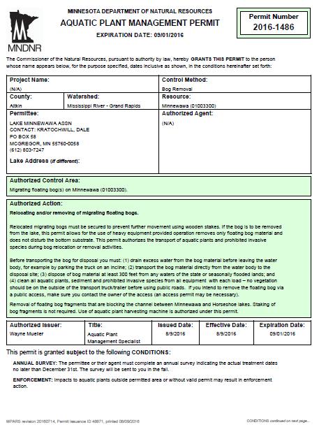
4 4
5 5
6 Lake Minnewawa Association Aquatic Plant Mechanical Harvesting Policy, June 2016 Lake Minnewawa is classified by the Minnesota Department of Natural Resources (MN DNR) as a eutrophic type lake. One characteristic of this type of lake is an abundant level of aquatic vegetation. Mechanical harvesting has proven to be an effective and environmentally safe means by which to control excessive aquatic vegetation growth. It is also one of the few options to remove the nutrients, which are bound in plants from the lake. LMA seasonal harvesting operations are conducted through a permit issued by MN DNR authorizing the destruction of aquatic vegetation and is subject to all terms and conditions put forth by MN DNR. The seasonal permit allows harvesting of submerged vegetation in offshore areas that are greater than 150 feet from shore and is the primary mission of LMA harvesting operations. The permit allows operations to begin on June 1 st and expires on September 1 st. The actual start and end dates are dependent on seasonal growth variations that rely on several environmental factors and harvesting budget. The lake is divided into five harvesting zones. LMA staff will perform regular reconnaissance surveys of the five zones to evaluate when and to what extent mechanical harvesting is appropriate. Initially, each zone will be evaluated on the bases of where the greatest public use is impaired by offshore emergent vegetation. The primary method used for gauging vegetation density is comparing time spent on a respective area to the amount tonnage (loads) removed. Harvesting effectiveness is dependent on vegetation density and lake access location for the shoreline trailer and truck. The closer the access point is to the area being cut, the more effective the harvesting operation will be. Therefore, duration of time spent in a zone will not be the sole factor used to determine harvesting efficiency or completion of a zone. Harvesting operation employs a crew that work Monday through Friday so as not to conflict with weekend enjoyment of the lake. The Harvesting Manager has the day to day authority and responsibility for the coordination and operation of harvester and the associated equipment. For reasons of insurance limitations and liability only LMA board of directors and harvesting employees are allowed to operate and service harvester, or drive vehicles. Riding along on harvester or truck is not allowed. Reporting of harvesting operations will be posted on LMA Website ( and updated every two weeks starting on the first of June. This will provide interested parties a convenient way to access information regarding LMA seasonal harvesting operations. LMA seasonal harvesting permit is for offshore control of aquatic vegetation to provide clear passage in public areas of the lake and does not include cutting vegetation for individual riparian owners to gain access to open water. Individual riparian owners that feel they need assistance in gaining access to open water must contact MN DNR to apply for a permit to destroy aquatic vegetation for that purpose. If the MN DNR grants the riparian owner a permit allowing the removal of vegetation to gain access to open water, it is the riparian s responsibility for the removal of the vegetation and maintaining the channel to open water. The riparian may remove the vegetation themselves or hire a private company to remove the vegetation. LMA will endeavor to assist riparian owners that request vegetation removal by the harvester machine to gain access to open water; however mechanical limitations or navigation hazards may limit the ability or effectiveness of vegetation removal. Delays may also be experienced due to primary mission of harvesting operations or work schedule. 6
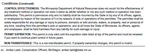
7 Lake Minnewawa Association Aquatic Plant Mechanical Harvesting Policy, June 2016 The riparian owner must submit a signed copy of the required DNR permit with the property owner s first and last name, and property I.D. number to LMA P.O. Box 58 McGregor, MN Attention Harvesting Operations before any work will be performed. The harvesting crew will make every effort to be at the riparian owner s property within two (2) weeks of confirmation of proper DNR permitting. The riparian owner is responsible to make a sign using 3 or 4 inch tall characters displaying the required DNR permit number attached to the riparian owners dock. LMA harvester will cut a path that is consistent with DNR regulations and no closer than 15 feet to the front of riparian owners dock. Each riparian owner will be limited to a maximum of two (2) clearing passes per season. Criteria which determines when and where aquatic vegetation is to be harvested includes: Operating Budget: Based on funds held by LMA and funds available from other sources a harvesting budget is established. The budget will determine the length of the harvesting season. Harvesting season will not be expanded beyond the established seasonal budget. Weather: Harvesting operations will be delayed if weather conditions jeopardize the safety of the crew members or risk damage to harvesting equipment. Seasonal Climate Trend: Increased light penetration in the water column, high water temperatures and low water levels increase the likelihood of excessive vegetation growth. Under these conditions the planned harvesting schedule will be adjusted as needed to prioritize areas to maximize coverage based on remaining operating budget. Mechanical Limitations: The mechanical harvester is designed to cut aquatic vegetation. However, the harvester is not able to cut some type of plants. Server damage to mechanical harvester will result from dredging mud from bottom of lake. Dredging is an illegal act and will not be allowed. No-Cut Areas: 5.1) Critical Native Plants These areas are classified by MN DNR to have significant populations of beneficial or protected native plants. 5.2) Navigation Hazards These are areas of rock/rocky structure and shallow areas where the mechanical harvester cannot operate due to barge draft. 5.3) Undeveloped Shoreline These are undeveloped areas and harvesting will not be done. 5.4) Shoreline Docks Areas around riparian owned docks and boat lifts including swimming area and floating rafts. 5.4) North End Bay The east side of this area is an imaginary line that extends from Warner s Point in a north easterly direction to the western most property line of parcel number on the north shore of the bay. 5.5) South End Bay The south bay area that lies to the west and south of an imaginary line that extends from western shoreline to the eastern shoreline just south of Minnewawa Sportsman s Club. 5.6) Sensitive Habitat These are designated by MN DNR as important fish spawning and/or juvenile fish cover areas. Approved On 7/15/2016 7
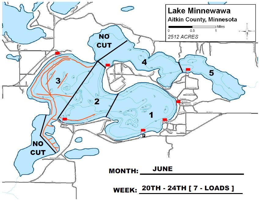
8 Lake Zone Map The lake is divided into five harvesting zones. Lake Minnewawa Association (LMA) staff performs regular reconnaissance surveys of the five zones to evaluate when and to what extent mechanical harvesting is appropriate. Initially, each zone is evaluated on the bases of where the greatest public use is impaired by offshore submerged vegetation. 8
9 June Harvesting Report LMA began 2016 harvesting operations on Monday, June 6 th. As expected for the beginning of the season aquatic vegetation conditions on the lake were low. This condition was consistent for the first two weeks of operation. The rate of harvesting in zone [1] and [2] was slow, taking most of the day to accumulate a full load. Zone [3] proved to have a higher concentration of vegetation resulting in a higher percentage of loads than zone [1] and [2] combined. Zone [4] was harvested the last week of June and produced one full load. This was in part due to only part of zone [4] being harvested that week. A total of 12 loads were taken from the lake during the month of June. Each load has an average weight between seven and eight tons. A total of twenty work days were possible in the month of June. Nine days were spent harvesting, nine days were canceled due to high wind and/or rain, and two days were lost because of trailer brake problem. Month of June Work Days High Wind Days Rain Days Break Down Days Vegetation Full Loads Week # Week # Week # Week #

10 10
11 11
12 July Harvesting Report Weather was a significant factor in the number of harvesting days this month. The amount of precipitation during the month resulted in the lake level raising but also caused the water clarity to diminish to a point that made it difficult to identify submerged vegetation in areas allowed to be cut. Despite these conditions the harvester has completed two trips around the lake. Overall vegetation density in the lake appears to be lower this year. By the start of the fourth week of July four hours of work produced only 1/8 of a full load on the harvester machine. Harvesting operations were suspended for the remainder of the week. Harvesting crew monitored the lake during the week but navigation on the lake remained very good. Harvesting operations will resume the first week of August if conditions change. A total of 11 loads were taken from the lake during the month of July. The season total is now 23 loads. Each load has an average weight between seven and eight tons. A total of twenty work days were possible in the month of July. Seven and one half days were spent harvesting, six and one half days were canceled due to high wind and/or rain, and one day not worked due to holiday. The last week of July harvesting operation was suspended. Month of July Work Days Holiday Day High Wind & Rain Days Break Down Days Vegetation Full Loads Week # Week # Week # Week #
13 13
14 14
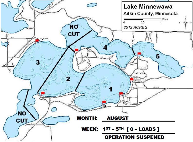
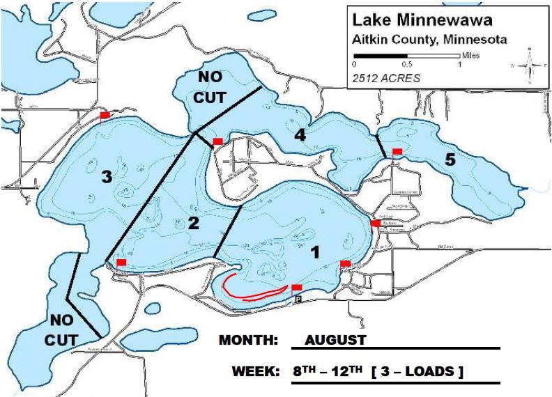
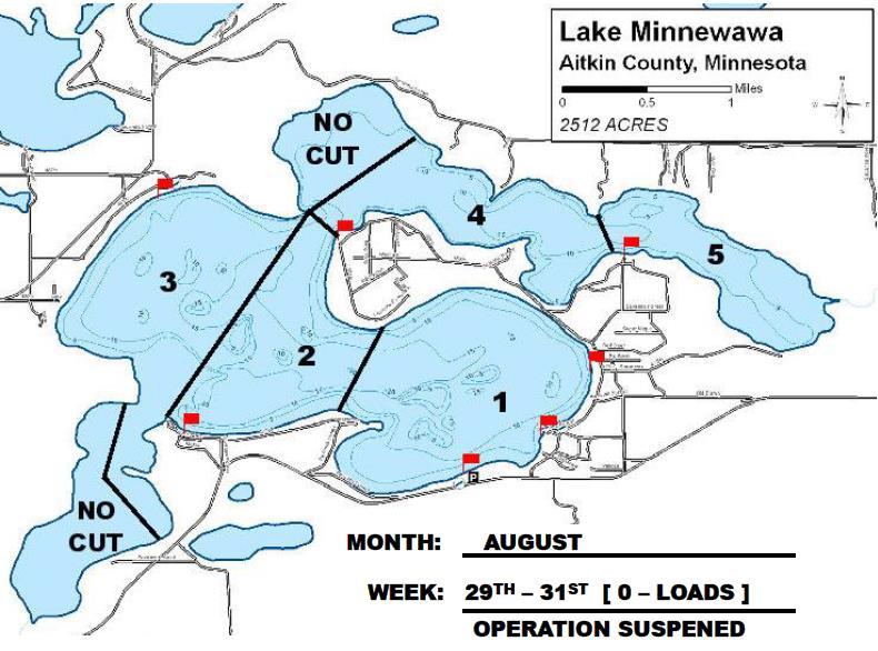
15 August Harvesting Report Harvesting crew did a survey of the lake during the last few days of July. Navigation on the lake remained very good so harvesting operation was suspended for the first week of August. Harvesting operations resumed on Monday, August 8 th, however, shortly into the first day the harvester was shut down due to hydraulic motor shaft seal and adapter fitting leaking. Received Minnesota DNR permit Tuesday, August 9 th for moving vegetation bog that is blocking entrance to channel. Harvester put back into service after replacing failed parts on Tuesday. Weather conditions continue to be a significant factor in the daily harvesting operations. A storm that moved through the area on Tuesday night, August 9 th produced strong winds out of the east. This storm adversely affected the Wild Rice beds and vegetation in East Bay. Various size portions have broken loose and were driven by the strong wind westward into the lake. Other factors contributed to this condition; the lake level is still high especially for this time of year and boat traffic. The vegetation bog blocking the channel entrance has been broken in to smaller portions by boats ramming a path through the vegetation bog in an effort to travel between the two lakes. The harvester operated only three days during the second week of August. The third week of August the harvesting operations focused on collecting floating vegetation bogs pieces that broke off and moved out of East Bay under special permit granted by Minnesota DNR permit. Additionally, vegetation bog pieces that broke off and floated out of North Bay and drifted in to the north shore in various places. Two north shore lake shore property owners had filed permit application with Minnesota DNR to remove vegetation bog from their shore, but were dropped by the DNR because the special permit granted by Minnesota DNR already existed. A total of 21 loads were taken from the lake during the month of August. The season total is now 44 loads. A total of twenty three work days were possible in the month of August. Eight days were spent harvesting, three days were canceled due to high wind and/or rain, and nine days not worked. The first week of August harvesting operation was suspended. The last three days of August harvesting operation will be suspended. Month of August Work Days No Work Day 15 High Wind & Rain Days Break Down Days Vegetation Full Loads Week # Week # Week # Week # Week #
16 16
17 17
18 18
BIG ROCHE A CRI LAKE CHARACTERISTICS
 BIG ROCHE A CRI LAKE CHARACTERISTICS Lake Description Big Roche Cri Lake is located in north central Adams County and has a surface area of 205 acres, a shoreline length of 6.1 mile, a volume of 6,993
Shoreland Rules Revision Project Using GIS in North-Central Minnesota
 Shoreland Rules Revision Project Using GIS in North-Central Minnesota Andrew J. Williquett Department of Resource Analysis, Saint Mary s University of Minnesota, Minneapolis, MN 55404 Keywords: GIS, docks,
Sediment Management Alternatives Analysis
 Conservancy District April 19, 2017 Sediment Management Alternatives Analysis Report prepared for the Conservancy District -Unionville, IN Report By: KCI Technologies, Inc. 6983 Corporate Circle Indianapolis,
Survey of Bottom Substrate Composition and Fish Habitat Value at Nett Lake
 Survey of Bottom Substrate Composition and Fish Habitat Value at Nett Lake Prepared by: Frank G. Stone, U.S. Fish & Wildlife Service Ashland FRO May 2006 The objective of this project was to characterize
Control of Eurasian Milfoil (Myriophyllum spicatum) using wind powered water circulators at Lake Cayamant, Quebec, CANADA.
 using wind powered water circulators at Lake Cayamant, Quebec, CANADA.") 146 Dalesville, Brownsburg-Chatham. Quebec,Canada. J8G-1H4 Tel : 450-533-9191 Fax : 450-533-9175 E-mail : info@lake2000.com Web : www.lake2000.com Control of Eurasian Milfoil (Myriophyllum spicatum) using
146 Dalesville, Brownsburg-Chatham. Quebec,Canada. J8G-1H4 Tel : 450-533-9191 Fax : 450-533-9175 E-mail : info@lake2000.com Web : www.lake2000.com Control of Eurasian Milfoil (Myriophyllum spicatum) using
CHAPTER 6 ADDITIONAL STANDARDS APPLYING TO SHORELAND AREAS AND PUBLIC WATERS
 CHAPTER 6 ADDITIONAL STANDARDS APPLYING TO SHORELAND AREAS AND PUBLIC WATERS Section 1 Intent. 49 Section 2 Floodplain Requirements 49 Section 3 Water-Oriented Accessory Structures 50 Section 4 Stairways,
Minnesota Department of Natural Resources. Aquatic Plant Management Program
 Minnesota epartment of Natural Resources Aquatic Plant Management Program The Goal of the MN NR s Aquatic Plant Management Program-APM Protect & enhance Minnesota s aquatic resources, while allowing lakeshore
Cedar Lake Aquatic Ecosystem Restoration Feasibility Study, Cedar Lake, Indiana. Frequently Asked Questions November 2016
 Cedar Lake Aquatic Ecosystem Restoration Feasibility Study, Cedar Lake, Indiana Frequently Asked Questions 1. Why is dredging only occurring in specific locations? The locations and the quantity of material
Boy Lake CASS COUNTY
 Boy Lake 11-143- CASS COUNTY Summary Boy Lake is located near Remer, MN in Cass County. It covers 3,452 acres, which places it in the upper 1% of lakes in Minnesota in terms of size. Boy Lake has two main
Energy Performance Systems, Inc.
 Energy Performance Systems, Inc. Owner & Developer of the Whole Tree Energy Technology 13 November 2012 Project Title: Improving the Efficiency of Planting, Tending and Harvesting Farm-Grown Trees for
DREDGING THE ONE STOP FOR ALL YOUR DREDGING SOLUTIONS
 DREDGING THE ONE STOP FOR ALL YOUR DREDGING SOLUTIONS EDITION 2017 1 INDEX INTRODUCTION page 3 The Dutch know dredging State of the art dredge design AMPHIBIOUS EXCAVATORS page 5 Applications Features
Avista Dam Relicensing Factsheet Commenting on the Draft License Application
 Avista Dam Relicensing Factsheet Commenting on the Draft License Application Please Note: This is intended for informational purposes only and does not constitute legal advice. The life of every river
vice ark Ser a#onal P N
 Na#onal Park Service Great lakes Fisheries Commission USGS Na#onal Great Rivers Research & Educa#on Center Species Maximum Size Food Source Fun Fact Bighead Silver Black Grass 110 lbs, 55 inches 100 lbs,
Lake Pepin TMDL Water Quality Objectives
 some preliminary thoughts on how Upper Mississippi River Environmental Pool Plan Restoration Features and Activities may relate to Lake Pepin TMDL Water Quality Objectives TMDL = WLA + LA + MOS + RC Scot
Where Funds are Spent
 Page 1 of 10 DNR FY 2014-15 Budget 2013 Legislative Session Where Funds are Spent The DNR is organized into seven operating divisions, or programs, for managing where funds are spent. The Divisions are
Climate: describes the average condition, including temperature and precipitation, over long periods in a given area
 Ch. 6 - Biomes Section 6.1: Defining Biomes Biome: a group of ecosystems that share similar biotic and abiotic conditions, large region characterized by a specific type of climate, plants, and animals
The COLA Experience. A Partnership to Save the Lake
 The COLA Experience A Partnership to Save the Lake State Map County map Lake map Lac Courte Oreilles Watershed 68,990 ac Lac Courte Oreilles Hayward Round L Grindstone L LCO Sand L Whitefish L Lac Courte
(1)(A)Inventory of the following existing natural resources on the USFSP Campus or within the context area adjacent to the University.
(A)Inventory of the following existing natural resources on the USFSP Campus or within the context area adjacent to the University.") 13. 6C-21.208 CONSERVATION ELEMENT Information Sources George F. Young, Interview notes, June 2002 Sasaki Associates, Inc., interview notes, April, 2000 Interviews between DRMP Staff and USF Staff, May,
13. 6C-21.208 CONSERVATION ELEMENT Information Sources George F. Young, Interview notes, June 2002 Sasaki Associates, Inc., interview notes, April, 2000 Interviews between DRMP Staff and USF Staff, May,
Gull Lake CASS & CROW WING COUNTIES
 Gull Lake 11-0305-00 CASS & CROW WING COUNTIES Summary Gull Lake is located just northwest of Brainerd, Minnesota, on the border of Cass and Crow Wing Counties. It covers 9,947 acres, which places it in
Appendix B: Aquatic Herbicide Application Methods
 Appendix B: Aquatic Herbicide Application Methods William T. Haller: University of Florida, Gainesville FL; whaller@ufl.edu Introduction All pesticide labels contain very specific information regarding
Part 46 Training Plan Guide
 Part 46 Training Plan Guide Mine Safety and Health Administration 1 The purpose of this document is to assist you (mine operator and independent contractor) in developing a Part 46 training plan. This
Release of RFP February 9, 2017 RFP Questions and Clarifications Deadline February 16, 2017 at 4 p.m.
 Request for Proposals Temporary Staffing Services North St. Louis Soil and Water Conservation District 307 First St S Ste 114 Virginia MN 55792 I. Introduction The North St. Louis Soil and Water Conservation
Duwamish Waterway Self Guided Tour: Turning Basin Number Three and Terminal 105 Aquatic Habitat Restoration Sites
 Duwamish Waterway Self Guided Tour: Turning Basin Number Three and Terminal 105 Aquatic Habitat Restoration Sites Text and illustrations in the following pages include: (1) summary information describing
Chesapeake Bay Report Card 2016
 hesapeake Bay Report ard 216 University of Maryland enter for Environmental Science Fun for you and your family Stewardship is defined as the responsible oversight and protection of something considered
2. Does not require, involve or include any additions to, or repair or modification of, the existing foundation.
 SECTION 3109 STRUCTURES SEAWARD OF A COASTAL CONSTRUCTION CONTROL LINE 3109.1 General. The provisions of this section shall apply to the design and construction of habitable structures, and substantial
EUTROPHICATION. Student Lab Workbook
 EUTROPHICATION Student Lab Workbook THE SCIENTIFIC METHOD 1. Research Background literature research about a topic of interest 2. Identification of a problem Determine a problem (with regards to the topic)
MANAGING MINNESOTA S SHALLOW LAKES FOR WATERFOWL AND WILDLIFE
 MANAGING MINNESOTA S SHALLOW LAKES FOR WATERFOWL AND WILDLIFE Shallow Lakes Program Plan Minnesota Department of Natural Resources Division of Fish and Wildlife Wildlife Management Section December 2010
Cost-Effectiveness Analysis of Methods to Rehabilitate Shallow Lakes
 Cost-Effectiveness Analysis of Methods to Rehabilitate Shallow Lakes Patrick G. Welle, Ph.D.* Bemidji State University Paper Submitted for the Fifth Annual Conference of the Society for Benefit-Cost Analysis
Comparative Analysis of Minnesota Lakes Treated with Alum to Inform Spring Lake Treatment
 Comparative Analysis of Minnesota Lakes Treated with Alum to Inform Spring Lake Treatment Prepared for the Prior Lake Spring Lake Watershed District (PLSLWD) April 23, 2013 Comparative Analysis of Minnesota
Design Features of Constructed Wetlands for Nonpoint Source Treatment. September 1995
 Design Features of Constructed Wetlands for Nonpoint Source Treatment September 1995 Brochure written by William W. Jones, School of Public and Environmental Affairs, Indiana University, Bloomington, Indiana.
ADDRESSING CLIMATE CHANGE ADAPTATION IN EASTERN ONTARIO APRIL 15, 2013
 ADDRESSING CLIMATE CHANGE ADAPTATION IN EASTERN ONTARIO APRIL 15, 2013 IPCC DEFINITION UNFCCC DEFINITION Climate change in Intergovernmental Panel on Climate Change (IPCC) usage refers to a change in the
OUR GOAL IS TO PREVENT SPILLS ENTIRELY
 OUR GOAL IS TO PREVENT SPILLS ENTIRELY OUR GOAL IS TO NEVER HAVE AN OIL SPILL, AND THE INDUSTRY TAKES EXTENSIVE PRECAUTIONS TO PREVENT SPILLS FROM OCCURRING. TOPICS FOR DISCUSSION WHAT ARE OUR PRIMARY
WATER LEVELS ON THE GREAT LAKES
 OHSU EP-101 2013 BACKGROUND There is something about the movement of waves against the beach, the sight of a sailboat going past, and the ability to plunge in to the water on a hot summer day that attracts
CHAPTER 7 TABLE OF CONTENTS
 CHAPTER 7 TABLE OF CONTENTS CHAPTER 7 IMPLICATIONS FOR RECREATIONAL WATERS... 1 BACKGROUND... 1 WHY ARE CYANOBACTERIA A PROBLEM IN RECREATIONAL WATERS?... 1 Public Health Concerns... 2 MANAGING AND RESPONDING
Marine Fueling Facility Program Update Advisory
 Marine Fueling Facility Program Update Advisory Bruce Marshall Harbor Director Bill Helbig Interim Engineering Director Jeff Smith Finance Director August 13, 2012 Program Update History Marine Fuel Market
Visitor Contact Station Water Taxi Dock WATER TAXI ALTERNATE. Long Island ROUTE SHIPPS BAY. Mill Landing Water Taxi Dock WATER TAXI SCALE IN FEET
 San db NORTH ALTERNATE ROUTE Back Bay National Wildlife Refuge Long Island w Ne d ge R B ri y d Ch Pkw mo Ne ck Rd Mill Landing Water Taxi Dock iver R d Nim ty K C A B Pr in Way Point Water Taxi Dock Shared
Soil Permeability Demonstration
 Soil Permeability Demonstration Grade Level: 6-12 Subject Area: Soil science, Aquaculture Time: This will take one hour to drill holes in the bucket and acquire the various soils. This will take one hour
Mechanical Loading Dock Levelers
 Mechanical Loading Dock Levelers With over 30 years of experience manufacturing quality loading dock equipment, Pentalift is your single-source supplier for loading dock levelers, dock lifts, dock seals
Linda Cooper, Eno River State Park, Durham, NC
 Linda Cooper, Eno River State Park, Durham, NC 2 Rivers and Streams All 50 states, 2 interstate river commissions, American Samoa, Guam, Puerto Rico, the District of Columbia (collectively referred to
Media Release # 4. Melville Bay East Arnhem Land Mud Wharf Community Project Stages 7c & 7d
 Media Release # 4. Melville Bay East Arnhem Land Mud Wharf Community Project Stages 7c & 7d. 10.07.2016 Work is now underway on the next Stage of the Community Boat Ramp works as part of the $500,000 commitment
Climate Vulnerability Assessment: Wild Rice. Wild rice, known as Manoomin by the Ojibwe of northern Wisconsin, is a cultural
 Hansen 1 Hans Hansen ES 600 Conaway, Hitch Capstone Paper Draft 13 April 2015 Climate Vulnerability Assessment: Wild Rice Introduction Wild rice, known as Manoomin by the Ojibwe of northern Wisconsin,
Joint Public Notice. LOCATION: In Salmon Bay, Lake Washington Ship Canal, at Seattle, Washington.
 US Army Corps of Engineers Seattle District Joint Public Notice Application for a Department of the Army Permit and a Washington Department of Ecology Water Quality Certification and/or Coastal Zone Management
CHARLESTON HEAVY LIFT 2, INC.
 CHARLESTON HEAVY LIFT 2, INC. DERRICK BARGE OCEAN RANGER TARIFF NO. 1 Hoisting Rates, Charges, Rules and Conditions Governing Use Of 500-ton Capacity Derrick Barge OCEAN RANGER TARIFF THIS TARIFF IS SUBJECT
Appendix I Cost Engineering Pigs Eye Lake Ramsey County, MN Section 204 DRAFT. Draft Feasibility Study Report with Integrated Environmental Assessment
 Appendix I Cost Engineering Pigs Eye Lake Ramsey County, MN Section 204 Draft Feasibility Study Report with Integrated Environmental Assessment St. Paul District U.S. Army Corps of Engineers March 2018
SOUTH FORK AMERICAN RIVER (CHILI BAR), CALIFORNIA
, CALIFORNIA") Hydropower Project Summary SOUTH FORK AMERICAN RIVER (CHILI BAR), CALIFORNIA CHILI BAR HYDROELECTRIC PROJECT (P-2155) Photo Credit: PG&E This summary was produced by the Hydropower Reform Coalition and
Hydropower Project Summary SOUTH FORK AMERICAN RIVER (CHILI BAR), CALIFORNIA CHILI BAR HYDROELECTRIC PROJECT (P-2155) Photo Credit: PG&E This summary was produced by the Hydropower Reform Coalition and
Flotation Docking Systems INC
 Flotation Docking Systems INC P.O. Box 178 Cedarville, MI 49719 P: 906-484-3422 F: 906-484-2335 E: info@flotationdocking.com W: www.flotationdocking.com Beauty strength is having, showing, or possessing
Maryland s Living Shorelines Program. Bhaskaran Subramanian February 27, 2015
 Maryland s Living Shorelines Program Bhaskaran Subramanian February 27, 2015 1 Erosion & traditional approaches Living shorelines- what is it? Maryland s Living Shorelines program LS Law Products Funding-
Portage Lake Hubbard County
 Prepared in cooperation with the Minnesota Department of Natural Resources Minnesota Lake ID: 9- Area: acres Watershed Area: 6,7 acres Ecoregion: Northern Lakes and Forests (NLF) Portage Lake Hubbard County
GULF OF MEXICO - SEGMENT 2501
 GULF OF MEXICO - SEGMENT 2501 GULF OF MEXICO - SEGMENT 2501 LAND COVER BACTERIA CHLOROPHYLL A Impairment Concern No Impairments or Concerns GULF OF MEXICO - SEGMENT 2501 OTHER IMPAIRMENTS Bays & Estuaries
MetroLink Operations 700 South Ewing Street Saint Louis, Missouri
 Operating Procedure SOP # Date: Page 1 of 10 Classifications: OCC Rail Dispatchers Maintenance of Way - Contractors Other Departments: Real Estate Operation Safety - Risk Management - Engineering & New
Control of Eurasian Water Milfoil & Large-scale Aquatic Herbicide Use Updated July 2006 Prepared by WDNR Lakes and Aquatic Plant Management Staff
 Control of Eurasian Water Milfoil & Large-scale Aquatic Herbicide Use Updated July 2006 Prepared by WDNR Lakes and Aquatic Plant Management Staff Introduction The spread of aquatic invasive plants is a
Part I: Salish Sea Introduction. Review:
 Part I: Salish Sea Introduction Review: The Salish Sea The Salish Sea was formed about 20,000 years ago during the last ice age by the carving action of glaciers. There are 3 major parts of the Salish
STATE OF MINNESOTA MINNESOTA POLLUTION CONTROL AGENCY FINDINGS OF FACT
 p-ear2-44b STATE OF MINNESOTA MINNESOTA POLLUTION CONTROL AGENCY IN THE MATTER OF THE DECISION ON THE NEED FOR AN ENVIRONMENTAL IMPACT STATEMENT FOR THE PROPOSED RANDY S SANITATION TRANSFER FACILITY PROPOSED
(For individual lake and stream classifications in Cook County, refer to Appendix II)
") Article 7 Sec. 7.01 Shoreland Management Regulations Policy The uncontrolled use of shorelands of Cook County, Minnesota affects the public health, safety and general welfare not only by contributing to
Article 7 Sec. 7.01 Shoreland Management Regulations Policy The uncontrolled use of shorelands of Cook County, Minnesota affects the public health, safety and general welfare not only by contributing to
Biodiversity Debate. To evaluate the biological, aesthetic, ethical, social and economic arguments with regard to maintaining biodiversity.
 Purpose: Summary: To evaluate the biological, aesthetic, ethical, social and economic arguments with regard to maintaining biodiversity. In this exercise, students will hold a debate about the construction
SECTION 11: REGULATORY FLOODWAYS
 SECTION 11: REGULATORY FLOODWAYS Contents 11.1. The Floodway... 11-2 11.1.1. The floodway concept... 11-2 11.1.2. Floodway map... 11-2 11.1.3. Floodway permitting... 11-3 11.1.4. Changing the floodway...
Risk Assessment Needs for Land Management Decisions at Cherry Point, Whatcom County, Washington
 Piening and others: Risk Assessment Needs for Cherry Point Risk Assessment Needs for Land Management Decisions at Cherry Point, Whatcom County, Washington Carol Piening, John Boettner, Bill Graeber, and
2. Hydropower's Unexpected Side Effect
 trie feasibility studies. Under this program the St. Anthony Falls Hydraulic Laboratory is preparing feasibility analyses for clams located at St. Cloud, Granite Falls, Kettle River, Anoka, Lanesboro,
Occupational Safety and Health: The First Step Towards Reducing Disparities in Louisiana
 Volume 9, Issue 2, April 2012. Scholarly Note. 1-6. Occupational Safety and Health: The First Step Towards Reducing Disparities in Louisiana Theresa
33. Fate of pesticides in soil and plant.
 33. Fate of pesticides in soil and plant. What Happens to Pesticides When a pesticide is released into the environment many things happen to it. Sometimes what happens is beneficial. For example, the leaching
Stream Watch Visual Survey Instructions
 Stream Watch Visual Survey Instructions The Stream Watch Visual Survey is based on assessment parameters from the EPA's Rapid Bioassessment Protocol Habitat Assessment, Georgia Adopt a Stream Visual Survey,
Rob; Sincerely, Brian Causton, President FMLA. Jim Russell, Vice President FMLA [67 Highland Crescent, Cambridge, ON, N1S 1M1]
![Rob; Sincerely, Brian Causton, President FMLA. Jim Russell, Vice President FMLA [67 Highland Crescent, Cambridge, ON, N1S 1M1]](/thumbs/74/71148940.jpg "Rob; Sincerely, Brian Causton, President FMLA. Jim Russell, Vice President FMLA [67 Highland Crescent, Cambridge, ON, N1S 1M1]") Attention: Mr. Rob Griffiths, Manager of Planning Development Services - Planning Division City of Kawartha Lakes 180 Kent St. W., Lindsay, ON, K9V 2Y6 September 6, 2006 Rob; DEDICATED TO THE PROTECTION
Attention: Mr. Rob Griffiths, Manager of Planning Development Services - Planning Division City of Kawartha Lakes 180 Kent St. W., Lindsay, ON, K9V 2Y6 September 6, 2006 Rob; DEDICATED TO THE PROTECTION
Port of Manzanillo. Port of Manzanillo: Climate Risks and Opportunities. IAIA Symposium: Sustainable Mega- Infrastructure and Impact Assessment
 Port of Manzanillo Port of Manzanillo: Climate Risks and Opportunities IAIA Symposium: Sustainable Mega- Infrastructure and Impact Assessment Panama City, December 3, 2015 Vladimir Stenek, IFC, World Bank
QUALITY FINANCIAL OPERATIONAL PERFORMANCE IMPROVEMENT DRIVEN BY DATA SCIENCE
 QUALITY FINANCIAL OPERATIONAL PERFORMANCE IMPROVEMENT DRIVEN BY DATA SCIENCE ENGAGING WITH PROSKRIPTIVE IS THE FIRST STEP TOWARD #HEALTHCAREINCONTROL QUALITY IMPROVEMENT REIMBURSEMENT MAXIMIZATION POPULATION
Memorandum. California public trust law governs the administration of tidelands and submerged lands in several ways:
 Memorandum To: Piers 30-32 Citizen s Advisory Committee ( CAC ) Land Use Subcommittee From: Brad Benson and Diane Oshima Date: January 10, 2013 Re: Public Trust Doctrine and BCDC The purpose of this memo
Programme of measures of the Finnish marine strategy
 Programme of measures of the Finnish marine strategy 2016 2021 SUMMARY On 3 December 2015, Finland's government approved the programme of measures for the Finnish marine strategy 2016 2021. The programme
People Move Our Port! 5th largest Port in the United States in total tonnage Who We Are In the Last Decade The Corpus Christi Region
 OPERATIONS FOREMAN OPERATIONS FOREMAN People Move Our Port! Port Corpus Christi (PCC) features two docks capable of loading/unloading petroleum coke, coal, bayrite and other dry bulk commodities directly
Lake Magda Nutrient TMDL FINAL
 Lake Magda Nutrient TMDL FINAL Prepared for Shingle Creek Watershed Management Commission Minnesota Pollution Control Agency September 2010 Lake Magda Nutrient TMDL FINAL Wenck File #1240-22 Prepared for:
Welcome to the Boulevard Lake Dam Class Environmental Assessment. Public Information Session #1. June 14, 2016
 Welcome to the Boulevard Lake Dam Class Environmental Assessment Public Information Session #1 June 14, 2016 Boulevard Dam - Overview Built approximately 100 years ago Owned and operated by the City of
Relicensing Study 3.5.1
 Relicensing Study 3.5.1 BASELINE INVENTORY OF WETLAND, RIPARIAN AND LITTORAL HABITAT IN THE TURNERS FALLS IMPOUNDMENT, AND ASSESSMENT OF OPERATIONAL IMPACTS ON SPECIAL-STATUS SPECIES Initial Study Report
GREAT LAKES WATER LEVEL REGULATIONS
 JOHN G. SHEDD AQUARIUM WHITE PAPER PROJECT 2011 GREAT LAKES WATER LEVEL REGULATIONS By: Beth Engel I. INTRODUCTION The Great Lakes Basin, storing 5,439 mi 3 of water, is comprised of the lakes and connecting
Chapter 3. Lake Assessments
 Chapter 3. Lake Assessments Introduction The Pelican Group of Lakes encompasses 4 lakes: Pelican, Little Pelican, Bass, and Fish. Although these lakes have somewhat different characteristics, they are
Project Review Application Form
 Project Review Application Form Information supplied in this application may be made public during consultation with adjacent municipalities, First Nations groups and other interested parties, as well
Lake Emily CROW WING COUNTY
 Lake Emily 18-0203-00 CROW WING COUNTY Lake Water Quality Summary Lake Emily is located on the eastern edge of the City of Emily, MN in Crow Wing County. It is a shallow lake that covers 720 acres and
Summary of PTTGC Oil Spill Incident and Execution
 Summary of PTTGC Oil Spill Incident and Execution Agenda 1. Sequence of Incident page 2 2. Refinery s Operation page 4 3. Execution Team page 5 4. Mitigation Plan page 5 5. Insurance Coverage page 6 For
HP Hardware Support Onsite Next Day Response
 HP Hardware Support Onsite Next Day Response This HP service provides high-quality remote and onsite support for your HP and Compaq branded hardware, and other eligible third party hardware products that
Dredging and Dredged Material Disposal Overview
 Dredging and Dredged Material Disposal Overview Tim Welp Timothy.L.Welp@usace.army.mil 601.634.2083 The process of dredging consists of the following stages: - Excavation (loosening or dislodging) of the
LAKE BELLAIRE SHORELINE SURVEY SUMMARY REPORT
 1 LAKE BELLAIRE SHORELINE SURVEY SUMMARY REPORT Three Lakes Association PO Box 689 Bellaire, MI 49615 by William Bohannon, Braden Ackerman, Wilhelmina Witt and TLA Volunteers August 30, 2008 3 Developed
These guidelines are to ensure systematic and consistent pier construction throughout the Jonathan s Landing development.
 PIER GUIDELINES 1 PIER CONSTRUCTION GUIDELINES These guidelines are to ensure systematic and consistent pier construction throughout the Jonathan s Landing development. 1. DEFINITIONS The following definitions
Manager Customer Service & Communications
 EMPLOYMENT OPPORTUNITY ANNOUNCEMENT Manager Customer Service & Communications NICTD intends to hire a pro-active and enthusiastic Manager Customer Service & Communications who will lead and supervise all
Integrating Water Quality and Natural Filters into Maryland s Marine Spatial Planning Efforts
 Integrating Water Quality and Natural Filters into Maryland s Marine Spatial Planning Efforts Nicole Carlozo NOAA Coastal Management Fellow July 31, 2014 Watershed-scale restoration targeting helps direct
AP Environmental Science
 AP Environmental Science Types of aquatic life zones MARINE Estuaries coral reefs mangrove swamps neritic zone pelagic zone FRESHWATER lakes and ponds streams and rivers wetlands Distribution of aquatic
This policy will generally explain the following in regards to the City sewerage collection systems:
 CITY OF SACO POLICY ON SEWER AND STORMWATER BACK-UPS PURPOSE The purpose of this policy is to explain how and why sewer or stromwater backups occur, what to do in the event a homeowner has a backup, and
Chapter 4 Watershed Goals and Objectives
 Chapter 4 Watershed Goals and Objectives Eight (8) long-term watershed goals have been developed by the NEW Watershed Advisory Group (WAG) after consideration of discussions held during monthly watershed
A Lake Classification and Conservation Portfolio for Wisconsin
 A Lake Classification and Conservation Portfolio for Wisconsin Kristen Blann Freshwater ecologist The Nature Conservancy Based on development of the lake classification and conservation portfolio for MN,
A light rain shortly after the water recedes / drains might be beneficial to wash off the mud on plants.
 June 30, 2009 PONDS AND FLOODED FIELDS With the recent rains and related flooding, many are asking the question, "How long can crops be under water and survive?" Corn and soybeans can normally only survive
PROPOSED SHIP TARIFF REGULATIONS OF THE FEDERATED STATES OF MICRONESIA
 PROPOSED SHIP TARIFF REGULATIONS OF THE FEDERATED STATES OF MICRONESIA PART 1. GENERAL PROVISIONS 1. 1 Authority. These regulations are hereby promulgated by the Secretary of the FSM Department of Transportation,
Annual Update. Large-Scale Oyster Restoration in Support of the Chesapeake Bay Agreement Oyster Goal. Stephanie Reynolds Westby, NOAA
 Annual Update Large-Scale Oyster Restoration in Support of the Chesapeake Bay Agreement Oyster Goal Stephanie Reynolds Westby, NOAA Susan Conner, USACE- Norfolk District Policy Drivers Executive Order
Maintaining and Improving the Health of All Minnesotans
 Protecting, Maintaining and Improving the Health of All Minnesotans 7/10/17 Stephanie Adams 12 Hwy 28 E St 2 Morris, MN 56267 Dear Stephanie: Subject: Initial Comment Letter, One Watershed One Plan Thank
INOVA Office Building I. Adolfson & Peterson Construction. Keri Burson:
 INOVA Office Building I Adolfson & Peterson Construction Keri Burson: kburson@a-p.com; 303-363-7101 Category #9 Best Building Project General Contractor ($10 - $40 Million) Why this project should win
Winter Drawdown Proposal for Control of EWM in Long Trade Lake. Informational Meeting Saturday, August 25, 2012
 Winter Drawdown Proposal for Control of EWM in Long Trade Lake Informational Meeting Saturday, August 25, 2012 Recent Management Summary Trade Lakes System Summer 2011 Aquatic Plant Management Plan for
THE BENEFITS OF MECHANICAL DEWATERING: CASE STUDY OF MACHADO LAKE ECOSYSTEM REHABILTATION PROJECT IN LOS ANGELES, CALIFORNIA
 THE BENEFITS OF MECHANICAL DEWATERING: CASE STUDY OF MACHADO LAKE ECOSYSTEM REHABILTATION PROJECT IN LOS ANGELES, CALIFORNIA Presented by: Thomas B. Amaro, VP/GM, Tim Azevedo, Chief Estimator Machado Lake
PE PLE WHO POLLUTED THE RIVER?
 UNIT 7 PEOPLE AND WASTE WHO POLLUTED THE RIVER? COUNTING ON PE PLE K-5 Activities for Global Citizenship METHOD Through an interactive story, K-2 students experience the pollution of a local river over
REQUEST FOR BIDS BUILDING DEMOLITION 102 W. Main St.
 531 N. Nash Street Hortonville, WI 54944-0099 Phone: 920-779-6011 Fax: 920-779-6552 www.hortonvillewi.org REQUEST FOR BIDS BUILDING DEMOLITION 102 W. Main St. Date Issued: February 5, 2016 Date Due: March
Welcome to the Public Information Centre. Red Hill Business Park South Transportation Master Plan Addendum. June 25, :00 p.m. to 8:00 p.m.
 Welcome Welcome to the Transportation Master Plan Addendum June 25, 2012 6:00 p.m. to 8:00 p.m. Please sign-in Background In 2006 the City of Hamilton completed the North Glanbrook Industrial Business
HENNEPIN COUNTY Department of Human Resources Hennepin County Government Center 300 South Sixth Street Minneapolis, MN 55487
 HENNEPIN COUNTY Department of Human Resources Hennepin County Government Center 300 South Sixth Street Minneapolis, MN 55487 http://hennepin.jobs INVITES APPLICATIONS FOR THE POSITION OF: Laborer, Seasonal
Chapter 6 Avoidance, Minimization, and Mitigation
 Chapter 6 Avoidance, Minimization, and Mitigation This chapter provides a summary of the mitigation measures that the City could implement to avoid, minimize, rectify, or compensate for impacts from the
Wetland Monitoring. City of Edmonton. Edmonton Wetlands Workshop December 4-5, 2013
 Wetland Monitoring City of Edmonton Edmonton Wetlands Workshop December 4-5, 2013 City of Edmonton Presentation Outline Kennedale Wetland Water Quality Sediment removal Vegetation management Biological