Using a Historic Change Analysis to Design Strategic Restoration/Preservation of Nearshore Ecosystems in Puget Sound
|
|
|
- Kevin Daniel
- 6 years ago
- Views:
Transcription


1 Using a Historic Change Analysis to Design Strategic Restoration/Preservation of Nearshore Ecosystems in Puget Sound Charles Si Simenstad Wetland Ecosystem Team School of Aquatic and Fishery Sciences University of Washington On behalf of the Puget Sound Nearshore Ecosystem Restoration Project (PSNERP) teams Restore America s Estuaries 2010 Restoring and Protecting Puget Sound s Nearshore Ecosystems; Tuesday, November 16
2 Message Historic change in nearshore ecosystem processes that sustain ecosystem functions, goods and services can be inferred from change in ecosystem structure Strategic planning of restoration and preservation can be informed by change analysis; where and what restoration/protection is needed cannot be arbitrary, i.e., more strategic by attending to types and scales of process change Puget Sound Nearshore Ecosystem Restoration Project s (PSNERP) Change Analysis forms foundational framework and geodatabase to identify and set priorities for nearshore restoration/protection to maximize benefit
3 Content 1. Role and approach of PSNERP Change Analysis in restoration/preservation planning 2. Synopsis of change in Puget Sound nearshore ecosystems 3. Implications for delivery of ecosystem functions, goods and services 4. Lessons learned


4 PSNERP NST: Change Analysis Restoration and Protection Portfolios Change Analysis: How have nearshore ecosystems changed? Strategic Needs Assessment: Where are the most problematic changes and why? Future Risk Assessment: How might future growth and development affect the nearshore? Science Guidance: restoration principles from literature and practice? Restoration and Protection Portfolios: What actions should we take and where? Management Measures: What can we do to protect and restore the nearshore?


5 So, what is wrong with Puget Sound s nearshore ecosystems?


6 Challenges: impediments to nearshore ecosystem restoration? adjacent upland development legacy contaminants point and nonpoint contaminant discharge freshwater flow regulation and diversion transportation and other public infrastructure Extensively industrialized Puyallup River delta
7 PSNERP CHANGE ANALYSIS Objective Infer magnitude and significance of impairment in nearshore ecosystem processes from historic changes in physical structure of nearshore environment consistent with conceptual model of relationships among ecosystem processes, structure and function. Approach Assess change in types and magnitude of historic changes in natural nearshore ecosystems over last ~ yr (~ to ), not as target for restoration but as guidance Scope and Focus comprehensive, Sound-wide along ~4,000 km shoreline spatially explicit changes in nearshore ecosystem processes ( process-based landscape/ecosystem organization 1907 Ashel Curtis photograph of Everett, Washington from Rucker Hill
 freshwater inflow sediment erosion & accretion particle")


8 CONCEPTUAL BASIS - PSNERP ECOSYSTEM STRUCTURE + components ECOSYSTEM PROCESSES Regional weather tectonic events tidal flooding wave energy Local hydrology (tidal and current movement) freshwater inflow sediment erosion & accretion particle transport Finite biogeochemical processing/cycling primary production food web transfer and connectedness decomposition reproduction ECOSYSTEM FUNCTIONS Millennium Ecosystem Assessment (MA 2003,2005; de Groot et al. 2002, etc.) Supporting fish and wildlife habitat biodiversity Provisioning food production food web sources coastal sediment supply Regulating wave attenuation sediment retention flooding mediation gas regulation Cultural recreation aesthetics science and education ecological interactions behavior
9 Nearshore Ecosystem Processes Examples of local ecosystem processes: Sediment Supply and Transport: supply (from bluff, stream and marine sources) and transport of sediments and other matter by water and wind Beach Erosion and Accretion: erosion and deposition (accretion) of sediments and mineral particulate material by water, wind and other forces Tidal Hydrology: localized tidal movements, differing from regional tidal regime mostly in tidal freshwater and estuarine ecosystems Localized Wind and Wave Inputs to the Shoreline: exposure to winddriven waves Distributary Channel Migration: combined freshwater and tidal flow influences on distributary channel form and location Tidal Channel Formation and Maintenance: geomorphic processes, primarily tidally driven, that form and maintain tidal channel geometry Freshwater Input: freshwater inflow from surface (streamflow) and groundwater (seepage) and mixing with seawater Detritus Recruitment and Retention: import and deposition of particulate (dead) organic matter Exchange of Aquatic Organisms: organism transport and movement Solar Radiation: exposure to solar radiation and resulting effects (e.g., radiant heat)
10 PSNERP Change Analysis: Shoreforms Stream delta Vegetated flat BARRIER Channels ESTUARY Tidal flat Tidal delta Alluvial River Valley Coastal Watersheds Embayments Bedrock Upland Vegetated Flats Tidal flat BARRIER Tidal delta LAGOON Channels Berm/Backshore Beachface Low-tide terrace BARRIER BEACH Cliff ROCKY Platform PLATFORM Alluvial Floodplain (surge plain) High tide flat Low tide flat RIVER DELTA Bluff face Berm/Backshore Beachface Low tide terrace BLUFF Berm/Backshore BARRIER Beachface Low tide terrace BEACH Berm/Backshore Beachface Low tide terrace POCKET BEACH Delta Beaches Rocky Coast Typical Puget Sound coastal landforms ( shoreforms ) (from Shipman et al. 2008)
11 NEARSHORE ECOSYSTEM PROCESSES Rocky rocky Shores shores Lagoon lagoon Nearshore Ecosystem Process Domains sediment supply and transport beach erosion and accretion CZ L-R L-R DZ Lagoon lagoon Pocket pocket Beach beach freshwater inflow tidal hydrology distributary channel migration tidal channel formation and maintenance R-L euryhaline unvegetated estuarine mixing R-L Barrier barrier Beach beach localized wind and wave inputs to shoreline River river Delta delta oligohaline transition freshwate r tidal Stream stream Delta delta L-R DZ NAP Coastal coastal Bluffs bluffs Stream stream - mouth Estuary estuary Longshore transport Drift cell processes DZ: Divergence Zone sediment delivery R-L: Right to Left sediment transport L-R: Left and Right sediment transport CZ: Convergence Zone sediment accretion/sink NAP: No Appreciable Drift Delta processes EU: euryhaline unvegetated EM: estuarine mixing OT: oligohaline transition FT: freshwater tidal
 for shoreline process units (SPU; left) and")
; stippling")
12 PSNERP Change Analysis: Geospatial Shoreline Process Units Delta Process Units Whidbey Basin example of hierarchical organization in PSNERP geographic scale units (GSU) for shoreline process units (SPU; left) and delta process units (DPU), with littoral drift cells (Drift Cell Type) components. Cross-hatching indicates overlap in SPU (in Divergence Zone and where No Appreciable Drift); stippling indicates where SPU and DPU overlap.

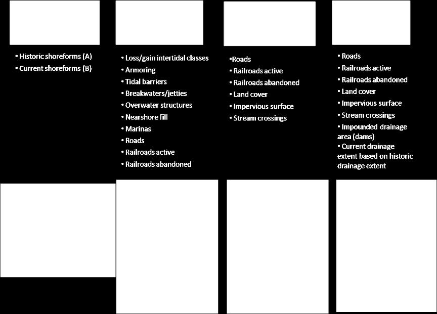
13 PSNERP Change Categories (Tiers)
 sub-basins 3.Within process units 4.")
14 PSNERP CHANGE ANALYSIS Results Categories & Display For each of the four change categories (tiers), we quantify nearshore ecosystem change and rank EFG&S impairment of nearshore ecosystem processes at four scales: 1.Comprehensive, Puget Sound-wide 2.Puget Sound (PSNERPdefined) sub-basins 3.Within process units 4.Among attributes of change within process units
 and from historic (left) to current (right) of different natural shoreforms (bottom).")
15 PSNERP CHANGE ANALYSIS Whidbey Subbasin example of transitions in shoreform type (Tier 1) to Artificial shoreform (top) and from historic (left) to current (right) of different natural shoreforms (bottom). HISTORIC CURRENT
16 Puget Sound-wide Change Shoreform Transitions (Tier 1) 5091 shoreform segments; 4300 unchanged (85.8%) ~76%

17 PSNERP CHANGE ANALYSIS Historic Shoreform Change Sound-Wide * * * * * *
, and percent change in wetland classes.")
18 PSNERP CHANGE ANALYSIS Whidbey Sub-Basin segment illustrating examples of shoreline alterations (Tier 2) changes; other features analyzed in this tier included nearshore fill, nearshore railroads (active and abandoned), and percent change in wetland classes.
19 Puget Sound-wide Change Shoreline Alterations (Tier 2) 20

20 PSNERP CHANGE ANALYSIS Cumulative Shoreline Alterations Cumulative stressors can be identified as spatiallyexplicit hot spots of impairment

, required to")
21 PSNERP CHANGE ANALYSIS Multivariate Analysis of Shoreline Alterations Groups of similarly changed PU inform distribution and extent of restoration or protection, and management measure(s), required to address strategic need
22 Scaling Observed Changes to Impairment* of Ecosystem Functions, Goods & Services (EFG&S) Shoreform Transition (Tier 1) Shoreforms are ranked by their relative ability to provide, regulate, support or enhance ecosystem functions, goods and services Shoreline Alteration, Adjacent Upland and Watershed Area Change (Tiers 2, 3, & 4) Attributes/modifications are ranked by the relative ability to reduce ecosystems ability to provide functions, goods, and services * impairment is PSNERP estimate of how and where observed changes to nearshore conditions reduces the ability of an ecosystem to provide functions, goods, and services
23 Ecosystem Functions Goods and Services (Millennium Ecosystem Assessment/World Resources Institute) Functions, goods and services that ecosystems provide to benefit human well-being and other life on Earth Provisioning: Food: crops; livestock; capture fisheries; aquaculture; wild foods Fiber: timber and other wood fiber; other fibers Biomass fuel Water (quantity) Genetic resources Biochemicals, natural medicines and pharmaceuticals Supporting: Nutrient cycling Soil formation* Food web* Photosynthesis* Sediment supply* Regulating: Air quality regulation Climate regulation: global; regional and local Water regulation (hydroperiod) Water purification and waste treatment Disease regulation Pest regulation Pollination Natural hazard regulation Cultural: Ethical value Existence values Recreation and ecotourism Education Millennium Ecosystem Assessment (MA) Ecosystems and Human Well-Being: Current State and Trends. Island Press, Washington, DC. World Resources Institute (WRI) Ecosystems and Human Well-Being: Synthesis. Millennium Ecosystem Assessment. Island Press, Washington, D.C.
 in terms of how changes would affect the ability of the nearshore ecosystem to provide, regulate, support or enhance human well-being")
24 RANKING OF EFG&S IMPAIRMENT BY NEARSHORE ECOSYSTEM CHANGE The NST individually and assigned ranks for each of the shoreform transitions (Tier 1), shoreline attribute (Tier 2), or change in adjacent upland and total watershed area characteristics (tiers 3 and 4) in terms of how changes would affect the ability of the nearshore ecosystem to provide, regulate, support or enhance human well-being in each EFG&S. EFG&S Ranks for Shoreline Alterations (Tier 2)

25 PSNERP CHANGE ANALYSIS Impairment due to Shoreline Alteration (Tier 2)
26 MAPPING SOURCES OF NEARSHORE ECOSYSTEM IMPAIRMENT Loss of delta wetlands Gain in Barrier Estuary and Barrier Lagoon Combined loss of Barrier Estuary and Closed Lagoon/Marsh Combined loss of Barrier Lagoon and Closed Lagoon/Marsh Gain in Barrier Beach and Barrier Estuary
27 MAPPING SOURCES OF NEARSHORE ECOSYSTEM IMPAIRMENT Gain of wetlands outweighs negative impact of roads Nearshore Roads, Abandoned Railroads, Wetland loss Oligohaline & Estuarine Mix

28 MAPPING SOURCES OF NEARSHORE ECOSYSTEM IMPAIRMENT Impervious surface Relatively more impervious surface and low intensity development

29 MAPPING SOURCES OF NEARSHORE ECOSYSTEM IMPAIRMENT Amount of impervious surface throughout watershed relative to other areas of sub-basin
30 Take-Home Message Framework of geospatial characterization of historic change in nearshore ecosystems that we can use to infer changes in ecosystem processes and functions, goods and services Informs spatially-explicit assessment of strategic restoration and protection needs Contributes to more sustainable restoration and protection planning and actions at all implementation scales


31 Thank You! For more information: Visit PSNERP website : Or, contact me directly: simenstd@u.washington.edu With acknowledgements to all the PSNERP team and particularly NST colleagues!
Why Care About Impacts to Natural Systems? Using Ecosystem Functions, Goods, and Services to Scale Changes to
 Why Care About Impacts to Natural Systems? Using Ecosystem Functions, Goods, and Services to Scale Changes to Nearshore Ecosystems in Puget Sound Curtis D. Tanner, U.S. Fish and Wildlife Service Miles
PUGET SOUND NEARSHORE ECOSYSTEM RESTORATION PROJECT
 PUGET SOUND NEARSHORE ECOSYSTEM OUTPUT MODEL DOCUMENTATION REPORT PUGET SOUND NEARSHORE ECOSYSTEM RESTORATION PROJECT Prepared in Support of Puget Sound Nearshore Ecosystem Restoration Project Chemine
AP Environmental Science
 AP Environmental Science Types of aquatic life zones MARINE Estuaries coral reefs mangrove swamps neritic zone pelagic zone FRESHWATER lakes and ponds streams and rivers wetlands Distribution of aquatic
Applying Ecosystem Services to Collaborative Forest Management Elk River Public Meeting
 Applying Ecosystem Services to Collaborative Forest Management Elk River Public Meeting Nikola Smith Ecologist and Ecosystem Services Specialist U.S. Forest Service Port Orford City Hall February 2, 2017
Criteria for Identifying and Prioritizing Habitat Protection and Restoration Projects on the Lower Columbia River and Estuary*
 Criteria for Identifying and Prioritizing Habitat Protection and Restoration Projects on the Lower Columbia River and Estuary* Ecosystem Criteria 1) Habitat Connectivity (0-10 points) This criterion recognizes
Natural Resources and Climate Resiliency in Germantown
 Natural Resources and Climate Resiliency in Germantown Ingrid Haeckel, Andrew Meyer, and Elizabeth Murphy NYSDEC Hudson River Estuary Program and Cornell University Presentation to the Town of Germantown,
Coastal studies in Long Term Ecological Research. Dan Reed Santa Barbara Coastal LTER
 Coastal studies in Long Term Ecological Research Dan Reed Santa Barbara Coastal LTER NSF s Long Term Ecological Research Program 24 sites representing a diverse array of biomes Major focus of research
Climate Data Training Session April 26, 2017 Ontario Science Centre
 Adaptive Management To Address Climate Change Uncertainty in EA Process A Case Study of the Don Mouth Naturalization and Port Lands Flood Protection Project EA (DMNP EA) Climate Data Training Session April
U.S. Army Corps of Engineers Mobile District
 U.S. Army Corps of Engineers Mobile District General Permit for Living Shorelines in Alabama Sandy P. Gibson Regulatory Specialist, Coastal Alabama Regulatory Division, Mobile District US Army Corps of
Gas Guzzlers. Biological Pump
 Gas Guzzlers Biological Pump Aquatic Biodiversity Chapter 8 Coral Reefs Open Ocean Deep Sea Marine equivalent of tropical rain forests Habitats for one-fourth of all marine species Coral polyps, which
Chapter 4 Watershed Goals and Objectives
 Chapter 4 Watershed Goals and Objectives Eight (8) long-term watershed goals have been developed by the NEW Watershed Advisory Group (WAG) after consideration of discussions held during monthly watershed
Environmental science: An interdisciplinary area of study that includes both applied and theoretical aspects of human impact on the world.
 Chapter 1: Environmental Interrelationships THE NATURE OF ENVIRONMENTAL SCIENCE Environmental science: An interdisciplinary area of study that includes both applied and theoretical aspects of human impact
Chapter 8: Aquatic Biodiversity
 Chapter 8: Aquatic Biodiversity APES 2013 1 Aquatic Life Zones 71% of the Earth is covered in saltwater 2.2% is freshwater Aquatic life zones are the equivalent of biomes Two major types: saltwater (marine)
What Are Environmental (Instream) Flows?
 Flows?") 1 What Are Environmental (Instream) Flows? Sustainable water management requires that both human needs and the needs of aquatic and riparian ecosystems be fulfilled. Dams and diversion of water for municipal
1 What Are Environmental (Instream) Flows? Sustainable water management requires that both human needs and the needs of aquatic and riparian ecosystems be fulfilled. Dams and diversion of water for municipal
Estuary Adventures. Background. Objective
 Estuary Adventures Objective Students will work in groups to understand the concept of estuaries, their importance, and the role that density plays in the mixing of fresh and salt water. Students will
Department of the Army Permit Application
 Department of the Army Permit Application DA File Number U.S. Army Corps of Engineers Honolulu District Date Received by CEPOH-RO Send Completed Application to: Honolulu District, U.S. Army Corps of Engineers
Conservation Assessment & Prioritization System (CAPS)
") Conservation Assessment & Prioritization System (CAPS) Assessing ecological integrity and supporting decision-making for land conservation, habitat management, project review & permitting to protect biodiversity
Conservation Assessment & Prioritization System (CAPS) Assessing ecological integrity and supporting decision-making for land conservation, habitat management, project review & permitting to protect biodiversity
Nitrogen Cycling, Primary Production, and Water Quality in the New River Estuary. Defense Coastal/Estuarine Research Program (DCERP)
") Nitrogen Cycling, Primary Production, and Water Quality in the New River Estuary Defense Coastal/Estuarine Research Program (DCERP) Introduction: A key theme of the ongoing DCERP program is monitoring
Nitrogen Cycling, Primary Production, and Water Quality in the New River Estuary Defense Coastal/Estuarine Research Program (DCERP) Introduction: A key theme of the ongoing DCERP program is monitoring
Natural Capital Ecosystem Services and Goods CVEN 4700L07
 Natural Capital Ecosystem Services and Goods CVEN 4700L07 Capitalism The economic system in which all or most of the means of production and distribution, as land, factories, railroads, etc., are privately
Adaptive Management of Puget Sound Chinook Salmon and Ecosystems. Stacy Vynne McKinstry Conference on Ecological and Ecosystem Restoration July 2014
 Adaptive Management of Puget Sound Chinook Salmon and Ecosystems Stacy Vynne McKinstry Conference on Ecological and Ecosystem Restoration July 2014 Puget Sound Partnership: Leading Puget Sound Recovery
Introduction to Ecosystem Services and Climate Change
 Introduction to Ecosystem Services and Climate Change Beto Borges Director, Community and Markets Program Forest Trends 4 April 2011 Ecosystems are the combined interactions of: Biological / living (plant,
Initial Application of a Landscape Evolution Model to a Louisiana Wetland
 Initial Application of a Landscape Evolution Model to a Louisiana Wetland by Carl F. Cerco PURPOSE: Corps planning projects encompass a wide variety of restoration goals. These include wetland restoration,
STREAM AND BUFFER AREA PROTECTION/RESTORATION
 STREAM AND BUFFER AREA PROTECTION/RESTORATION AMENDMENT OPTIONS TO STRENGTHEN POLICY IN HEADWATERS AREAS DRAFT SUBSEQUENT TO THE JANUARY 25, 2007 MEETING OF THE PLANNING COMMISSION ENVIRONMENT COMMITTEE
Hydrologic and Ecologic Impacts from the CERP Indian River Lagoon South Project
 Hydrologic and Ecologic Impacts from the CERP Indian River Lagoon South Project Dr. Gretchen Ehlinger Senior Biologist US Army Corps of Engineers Jacksonville District November 15, 2016 AWRA Conference
Puget Sound Nearshore Ecosystem Restoration Project
 Puget Sound Nearshore Ecosystem Restoration Project Strategic Restoration Conceptual Engineering Design Report May 2012 Final Puget Sound Nearshore Ecosystem Restoration Project Strategic Restoration Conceptual
Gulf of Mexico Program
 Gulf of Mexico Program Gulf of Mexico Program Mission Protect, restore, and maintain the Gulf of Mexico in ways consistent with the economic well-being of the region Committed to voluntary, non-regulatory
Project sponsors provided a brief presentation on their project(s), followed by comments from the Committee.
, followed by comments from the Committee.") WRIA 14 Salmon Habitat Recovery Committee Meeting April 17, 2014 Summary notes Project sponsors provided a brief presentation on their project(s), followed by comments from the Committee. Allyn Shoreline
WRIA 14 Salmon Habitat Recovery Committee Meeting April 17, 2014 Summary notes Project sponsors provided a brief presentation on their project(s), followed by comments from the Committee. Allyn Shoreline
Southern Africa perspective - Identification and Mapping National Freshwater Ecosystems Priority Areas in South Africa
 Southern Africa perspective - Identification and Mapping National Freshwater Ecosystems Priority Areas in South Africa SA National Wetland Inventory By N Mbona Outline National Wetland Inventory SA Wetland
B.C. Protected Areas Research Forum. Taking Nature s Pulse The Status of Biodiversity in British Columbia Putting Science into Action
 B.C. Protected Areas Research Forum Taking Nature s Pulse The Status of Biodiversity in British Columbia Putting Science into Action December 2, 2008 Who is Biodiversity BC? Ducks Unlimited Canada Environment
1. Philippines Coastal & Marine Resources: An Introduction
 1. Philippines Coastal & Marine Resources: An Introduction Thousands of islands. With its thousands of. islands, the Philippines has one of the longest coastlines in the world estimated at 36,289 kilometers.
Salt Marsh Restoration. Mary Ann Metcalf
 Salt Marsh Restoration Brent Manning Mary Ann Metcalf What is a salt marsh? Shallow areas flooded by ocean tides on a regular basis Found on margins of sounds and estuaries Plant communities adapted to
The Importance of the Pearl River to Mississippi s Estuarine Habitats Jennifer Buchanan Education Coordinator
 The Importance of the Pearl River to Mississippi s Estuarine Habitats Jennifer Buchanan Education Coordinator 2006 Pearl River Basin Symposium May 5-6, 2006 Topics for Discussion What s an estuary? Pearl
Maryland s Living Shorelines Program. Bhaskaran Subramanian February 27, 2015
 Maryland s Living Shorelines Program Bhaskaran Subramanian February 27, 2015 1 Erosion & traditional approaches Living shorelines- what is it? Maryland s Living Shorelines program LS Law Products Funding-
Fort Clatsop Restoration Project Summary Report
 Fort Clatsop Restoration Project Summary Report Report written by the Columbia River Estuary Study Taskforce October, 2007 Figure 1: Site Map Fort Clatsop Estuarine Restoration Project Columbia River Estuary
12/9/2011. Constructed Wetlands. Functions, Design Criteria
 Constructed Wetlands Functions, Design Criteria 1 2 Functions of Wetlands Flood mitigation Water filtration/purification (treatment) Wildlife habitat, biodiversity Biogeochemical cycles Recreation Reasons
CHAPTER 7. San Dieguito River Flooding Adaptation
 CHAPTER 7 San Dieguito River Flooding Adaptation This chapter includes a range of adaptation measures to address vulnerabilities from flooding along the San Dieguito River, including the river valley,
Why Do We Need Market Based Instruments to Conserve and Manage Alberta s Riparian Lands?
 Why Do We Need Market Based Instruments to Conserve and Manage Alberta s Riparian Lands? Judy Stewart, LL.M. Bow River Basin Council Workshop March 23, 2012 Outline What are riparian lands? Conserving
SEMESTER AT SEA COURSE SYLLABUS University of Virginia, Academic Sponsor
 SEMESTER AT SEA COURSE SYLLABUS University of Virginia, Academic Sponsor Voyage: Fall 2015 Discipline: Environmental Science EVSC 1559: Conservation of Natural Resources Division: Lower Faculty Name: Alan
HB1808 HD3 SDl CDl. June 2,2010
 EXECUTIVE CHAMBERS HONOLULU LINDA LINGLE GOVERNOR June 2, The Honorable Colleen Hanabusa, President and Members of the Senate Twenty-Fifth State Legislature State Capitol, Room 40 Honolulu, Hawaii Dear
Wetland Classification: A First Step. Naomi Detenbeck, US EPA, NHEERL, Mid-Continent Ecology Division, Duluth, MN
 Wetland Classification: A First Step Naomi Detenbeck, US EPA, NHEERL, Mid-Continent Ecology Division, Duluth, MN Photos courtesy of USDA NRCS Why classify? Why classify? The overall goal of classification
VIDEO: Riparian Forest Buffers: The Link Between Land & Water
 VIDEO: Riparian Forest Buffers: The Link Between Land & Water Introduction to Riparian Buffers Adapted from: Riparian Forest Buffers: The Link Between Land & Water. Maryland Cooperative Extension. Wye
Models Quantify the Relationship Between Water Flows/Levels and Ecological Endpoints
 National Conference on Ecosystem Restoration Los Angeles, CA July 20-24, 2009 Models Quantify the Relationship Between Water Flows/Levels and Ecological Endpoints Joseph V. DePinto, Todd M. Redder, Scott
Development of Eco-Compatible River Basin Management toward Nature Restoration ~ Case of Ise bay River Basin ~ Yuji Toda and Tetsuro Tsujimoto
 Development of Eco-Compatible River Basin Management toward Nature Restoration ~ Case of Ise bay River Basin ~ Yuji Toda and Tetsuro Tsujimoto Nagoya University Nature Restoration Projects of Japanese
Climate: describes the average condition, including temperature and precipitation, over long periods in a given area
 Ch. 6 - Biomes Section 6.1: Defining Biomes Biome: a group of ecosystems that share similar biotic and abiotic conditions, large region characterized by a specific type of climate, plants, and animals
3 Objectives 3 Ob jec tives
 3 Objectives 3 Objectives 3 Objectives 3 Objectives contents Objective number Page 3.1 Ki uta ki tai: mountains to the sea O1-O5 37 3.2 Beneficial use and development O6-O13 38 3.3 Māori relationships
Life in Water. Chapter 3
 Life in Water Chapter 3 Outline Hydrologic Cycle Oceans Shallow Marine Waters Marine Shores Estuaries, Salt Marshes, and Mangrove Forests Rivers and Streams Lakes 2 The Hydrologic Cycle Over 71% of the
Human-environment interaction and methods to analyze Ecosystem Services. Prajal Pradhan 21 June 2010
 Human-environment interaction and methods to analyze Ecosystem Services Prajal Pradhan 21 June 2010 the most subtle and dangerous threat to man s existence is the potential destruction, by man s own activities,
CHESAPEAKE BAY COMPREHENSIVE WATER RESOURCES AND RESTORATION PLAN. Habitat GIT Meeting 9 May 2017
 CHESAPEAKE BAY COMPREHENSIVE WATER RESOURCES AND 255 255 255 237 237 237 0 0 0 217 217 217 163 163 163 200 200 200 131 132 122 239 65 53 80 119 27 RESTORATION PLAN 110 135 120 252 174.59 112 92 56 62 102
EFFECT OF UPSTREAM DEVELOPMENT ON THE CLEAR CREEK AREA
 EFFECT OF UPSTREAM DEVELOPMENT ON THE CLEAR CREEK AREA Technical Memorandum Farming in the Floodplain Project Prepared for May 2017 PCC Farmland Trust Photo credit: Google Earth TABLE OF CONTENTS Page
Environmentally friendly drainage measures The use of two-stage profiles to improve diversity and water quality in agricultural streams
 Environmentally friendly drainage measures The use of two-stage profiles to improve diversity and water quality in agricultural streams European River Restoration Conference 2014, Vienna 27.-29.10.2014,
Coastal and Marine Ecosystem Services
 Coastal and Marine Ecosystem Services NEA WP 3b Kerry Turner UEA Laurence Mee - SAMS Mike Elliot - Hull Julian Andrews - UEA Tim Jickells - UEA Marije Schaafsma - UEA Gianna Palmieri - UEA Daryl Burdon
The role of freshwater ecosystems in carbon and nutrient cycling on the catchment scale. LSUE external launch Steven Bouillon
 The role of freshwater ecosystems in carbon and nutrient cycling on the catchment scale LSUE external launch Steven Bouillon Why are freshwater ecosystems important? CO 2 efflux 0.8 Pg C y -1 ~1.9 Pg C
HEIDI J. CLARK, PH.D.
 Qualifications Summary 15 years of research and consulting experience with industry, government, and scientific institutions Extensive field sampling and laboratory work on large and small projects in
Inventory, assessment and monitoring of wetlands: An integrated approach
 Inventory, assessment and monitoring of wetlands: An integrated approach Parikshit Gautam Director Freshwater & Wetlands Programme WWF - India Email: pgautam@wwfindia.net Taal 2007-12th World Lake Conference,
Guiding Principles on Sustainable Hydropower Development in the Danube River Basin
 Guiding Principles on Sustainable Hydropower Development in the Danube River Basin Lead Countries : Austria, Romania, Slovenia in the frame of the International Commission for the Danube River Protection
Coastal Resource Management Planning
 College of William and Mary W&M Publish Reports Spring 2011 Coastal Resource Management Planning Center for Coastal Resources Management, Virginia Institute of Marine Science Follow this and additional
CERP System Status Reports The Evolution from
 CERP System Status Reports The Evolution from 2006-2009 Eliza Hines 22 July 2009 Everglades Restoration Comprehensive Everglades Restoration Plan (CERP) 18,000 sq mile ecosystem Everglades & South Florida
Geomorphologic Condition and Shallow Aquifers
 Geomorphologic Condition and Shallow Aquifers Shann Stringer Center for Ecological Sciences Geomorphology Fluvial geomorphology is the study of the physics of water, sediment, riparian area, and floodplain
Biodiversity. The UNIVERSITY of OKLAHOMA
 Biodiversity The UNIVERSITY of OKLAHOMA Authors Paul Sandifer, PhD Director, Center for Coastal Environmental and Human Health Lee Bundrick Graduate Assistant, Stacey Weinstock Graduate Assistant, Susan
Coastal Wetland Status and Trends in the Chesapeake Bay Watershed
 Coastal Wetland Status and Trends in the Chesapeake Bay Watershed Donna Marie Bilkovic and Jeff Horan Designing Sustainable Coastal Habitats 16-17 April 2013 Virginia Institute of Marine Science www.ccrm.vims.edu
Water and Watersheds. Data Maps Action
 Water and Watersheds Data Maps Action What is the Wildlife Action Plan? Restore rare wildlife and habitats. Keep common species common. 2015 Revision: Partners in Conservation Science 2015 Revision Data
CHESAPEAKE CLEANING UP THE THE ECONOMIC BENEFITS OF A VALUATION OF THE NATURAL BENEFITS GAINED BY IMPLEMENTING THE CHESAPEAKE CLEAN WATER BLUEPRINT
 OCTOBER 2014 THE ECONOMIC BENEFITS OF CLEANING UP THE CHESAPEAKE A VALUATION OF THE NATURAL BENEFITS GAINED BY IMPLEMENTING THE CHESAPEAKE CLEAN WATER BLUEPRINT The Chesapeake Bay Foundation gratefully
5.5 NAVIGABLE WATERWAYS AND COASTAL ZONE
 5.5 NAVIGABLE WATERWAYS AND COASTAL ZONE This section discusses the effect of the Proposed Action on navigable waterways, and the Proposed Action s consistency with coastal zone policies. 5.5.1 Navigable
Lesson 2-2: Riparian Zones
 2-14 Lesson 2-2: Riparian Zones Time of Lesson: 1 hour Rationale: The purpose of this lesson is to define what a riparian zone is and link its importance for fish and other animals, and humans, and the
G.B. Sonny Hall, PhD. Veronika Thiebach
 G.B. Sonny Hall, PhD Technical Program Manager Veronika Thiebach Senior Assistant General Counsel St. Johns River Water Management District 1 SJRWMD MFLs Method MFLs Method Premises Case studies Lake Hiawassee
Climate Change, Human Activities, and the State of New Jersey. Michael J. Kennish Institute of Marine and Coastal Sciences Rutgers University
 Climate Change, Human Activities, and the State of New Jersey Michael J. Kennish Institute of Marine and Coastal Sciences Rutgers University New Jersey Climate and Environmental Change Conclusions from
Ecosystem Goods and Services: Where are We?
 Ecosystem Goods and Services: Where are We? Saskatchewan Prairie Conservation Action Plan Native Prairie Speaker Series November 27 th, 2013 Ken Belcher Department of Bioresource Policy, Business and Economics
FEMA s Mitigation Support for Resiliency: Innovative Drought and Flood Mitigation Projects
 FEMA s Mitigation Support for Resiliency: Innovative Drought and Flood Mitigation Projects Jordan Williams, CFM Eric Kenney, PE, CFM May 4, 2017 2 Hazard Mitigation Purpose: Research climate resilient
The Natural Capital Project: Approaches and Tools for Putting Ecosystem Services into Action
 The Natural Capital Project: Approaches and Tools for Putting Ecosystem Services into Action Lisa Mandle, Natural Capital Project lmandle@stanford.edu Rice University, Houston, June 2013 Mary Ruckelshaus,
NetMap Community Digital Watersheds & Shared Analysis Tools
 NetMap Community Digital Watersheds & Shared Analysis Tools Earth Systems Institute U. S. Forest Service, Pacific Northwest Experiment Station & Collaborating Agencies The NetMap Project Collaborators:
Sea-level Rise Science and Decision Making in an Uncertain Future. Rob Thieler U.S. Geological Survey Woods Hole, MA
 Sea-level Rise Science and Decision Making in an Uncertain Future Rob Thieler U.S. Geological Survey Woods Hole, MA Concepts Sea-level rise is one of the most certain impacts of climate change. There is
Lower Columbia River Restoration Prioritization Framework
 PNWD-3652 Lower Columbia River Restoration Prioritization Framework N.R. Evans 1 R.M. Thom 1 G.D. Williams 2 J. Vavrinec 1 K.L. Sobocinski 1 L.M. Miller 1 A.B. Borde 1 V.I. Cullinan 1 J.A. Ward 1 C.W.
Wetlands Project Guidance
 HABITAT Wetlands Project Guidance Stakeholder Informed Introduction Wetlands are lands saturated with water permanently or seasonally. Wetlands are typically defined by three characteristics: 1) The area
Threats to Forest Ecosystem Health Activities together influence ecosystem structure & function
 Threats to Forest Ecosystem Health Activities together influence ecosystem structure & function introduced species poor management air pollution global warming habitat fragmentation American Chestnut From
Long Island s. Environmental Issues. Environmental Issues. Environmental Setting. Environmental Setting. Suburbia and the Environment
 Environmental Issues Long Island s Environmental Issues Copyright 2011 AFG 1 agricultural land air pollution aquifers automobile barrier islands biozones fisheries groundwater recharge invasive species
Ecosystem Service Indicators and the GRI
 Ecosystem Service Indicators and the GRI Emerging philosophy and case studies of associated corporate sustainability reporting Tristan Tyrrell International Symposium 2011: Evaluating Biodiversity 17 February
Rangeland Conservation Effects Assessment Program (CEAP)
") Rangeland Conservation Effects Assessment Program (CEAP) Program Overview with Emphasis on the Literature Review of Rangeland Practices Pat L. Shaver, PhD Rangeland Management Specialist USDA-NRCS West
Rangeland Conservation Effects Assessment Program (CEAP) Program Overview with Emphasis on the Literature Review of Rangeland Practices Pat L. Shaver, PhD Rangeland Management Specialist USDA-NRCS West
LINKING FRESHWATER REARING HABITAT TO SKAGIT CHINOOK SALMON RECOVERY. Appendix C of the Skagit Chinook Recovery Plan
 LINKING FRESHWATER REARING HABITAT TO SKAGIT CHINOOK SALMON RECOVERY Appendix C of the Skagit Chinook Recovery Plan November 4, 2005 Eric M. Beamer Bob Hayman Devin Smith GIS work: Kate Ramsden and Karen
Chapter Concepts LIFE IN WATER. The Hydrologic Cycle. The Hydrologic Cycle
 Chapter Concepts Chapter 3 LIFE IN WATER The hydrologic cycle exchanges water among reservoirs The biology of aquatic environments corresponds broadly to variations in physical factors such as light, temperature,
Information Requirements Table for Liquid Waste
 Applicant Summary Tracking # Authorization # Applicant / Facility Name Ministry of Environment Prepared by: Title Date The Information Requirements Table (IRT) for Liquid Waste is a tool used by Ministry
A PILOT STUDY FOR ASSESSING FRESHWATER FLOW IMPACTS TO LOUISIANA ESTUARIES
 A PILOT STUDY FOR ASSESSING FRESHWATER FLOW IMPACTS TO LOUISIANA ESTUARIES Ryan Clark, Melissa Baustian, Eric White, Yushi Wang, Andrea Jerabek, and Harris Bienn Louisiana Water Conference March 27, 2018
Environment & Conservation Introduction
 Environment & Conservation Introduction Anacortes is blessed with an abundance of natural beauty. Residents identify marine shorelines, streams, lakes, forested areas, and other natural features as defining
Watershed BMPs. Notes from NRCS online site on BMPs. Focus on key BMPs
 Notes from NRCS online site on BMPs http://www.nrcs.usda.gov/technical/standards/nhcp.html Focus on key BMPs Function, benefits, and drawbacks listed Definition Novotny & Olem: BMPs are methods and practices
Community-Based Watershed Management
 Page 1 of 6 Ohio State University Fact Sheet School of Natural Resources 2021 Coffey Road, Columbus, Ohio 43210 Community-Based Watershed Management WS-0001-00 Joe Bonnell Project Coordinator, Ohio Watershed
(1)(A)Inventory of the following existing natural resources on the USFSP Campus or within the context area adjacent to the University.
(A)Inventory of the following existing natural resources on the USFSP Campus or within the context area adjacent to the University.") 13. 6C-21.208 CONSERVATION ELEMENT Information Sources George F. Young, Interview notes, June 2002 Sasaki Associates, Inc., interview notes, April, 2000 Interviews between DRMP Staff and USF Staff, May,
13. 6C-21.208 CONSERVATION ELEMENT Information Sources George F. Young, Interview notes, June 2002 Sasaki Associates, Inc., interview notes, April, 2000 Interviews between DRMP Staff and USF Staff, May,
Overview of emerging and new uses of the Ocean areas beyond national jurisdiction
 Overview of emerging and new uses of the Ocean areas beyond national jurisdiction Takehiro Nakamura Coordinator, Marine and Coastal Ecosystems Unit, United Nations Environment Programme Marine Ecosystem
Wildlife, Fisheries & Ecology Management
 TEKS CORRELATIONS & SUGGESTED PACING GUIDE Wildlife, Fisheries & Ecology Management icev Agricultural Science Site Meets 100% of TEKS 16 days of teaching material 1 History of Aquaculture 2.B; 2.C 2 Introduction
ESTUARY LESSON PLAN Eyes on the Estuaries
 Eyes on the Estuaries Lesson Plan ESTUARY LESSON PLAN Eyes on the Estuaries Focus Monitoring Living Resources in Estuaries Grade Level 9-12 Focus Question How can we monitor and compare living resources
13 th World Lake Conference
 13 th World Lake Conference Wuhan, China 1-55 November 2009 Ecosystem Approach to Lake Management 4 November 2009 Takehiro NAKAMURA Director UNEP International Environmental Technology Centre (IETC) 1
The Hypoxic Zone in the Gulf of Mexico
 The Hypoxic Zone in the Gulf of Mexico References Council Committee on Environmental and Natural Resources. 2003. An Assessment of Coastal Hypoxia and Eutrophication in U.S. Water. National Science and
Climate Change and Chesapeake Bay Habitats
 Climate Change and Chesapeake Bay Habitats Donna Marie Bilkovic STAC Chesapeake Bay Forage Base Workshop 12 November 2014 http://www.chesapeake.org/stac/ Virginia Institute of Marine Science www.ccrm.vims.edu
Rivermouth classification as a tool for guiding restoration
 Rivermouth classification as a tool for guiding restoration JEFF SCHAEFFER 1, J. C. NELSON 2, AND JAMES H LARSON 2, 1 USGS Great Lakes Science Center 2 USGS Upper Midwest Environmental Sciences Center
Navigating the U.S. Army Corps of Engineers Regulatory Process
 Navigating the U.S. Army Corps of Engineers Regulatory Process Angela Ryan Biologist Tampa Permits Section May 16, 2012 US Army Corps of Engineers JACKSONVILLE DISTRICT Regulatory Mission To protect the
ASSESSMENT OF SALINITY INTRUSION IN THE RED RIVER UNDER THE EFFECT OF CLIMATE CHANGE
 ASSESSMENT OF SALINITY INTRUSION IN THE RED RIVER UNDER THE EFFECT OF CLIMATE CHANGE Presented by NGUYEN Trung Viet Water Resources University, Vietnam March 2-4, 2011 Introduction Red River System is
The Currituck Sound Array: Introducing a new estuarine field site and test bed for Corps research. RSM Webinar, 18 February 2016
 The Currituck Sound Array: Introducing a new estuarine field site and test bed for Corps research. RSM Webinar, 18 February 2016 Heidi M. Wadman, Patrick J. Dickhudt U.S. Army Research and Development
NYS STANDARD/KEY IDEA/PERFORMANCE INDICATOR. LE Core* 1.1a, a-b, 4.1.1d, 4.1.f, 4.6.1a, 4.6.1c, 4.6.1d, 4.6.1g. Conducting an Experiment
 September Environmental Scientists The web of life The scientific method The Biosphere The third planet from the sun The universe Doppler Effect The sun s family The moon Tidal Forces The seasons The Earth