Willow Brook Catchment Project
|
|
|
- Audrey Chapman
- 6 years ago
- Views:
Transcription

1 Willow Brook Catchment Project Willow Brook Park Page 1
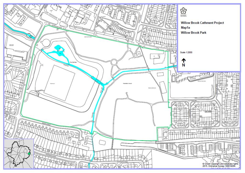
2 Contents 1. Introduction Background The Water Framework Directive and Drivers for Change The Willow Brook Catchment and Water Framework Status Willow Brook Park Reasons for the Project Key Themes Aims and Objectives Aims of the Project Objectives of the Project Benefits of the Project 7 3. The Project Area 1 Naturalise brook flood relief basin Area 2 Re-instatement of Wetland and Access Area 3 Access - Pathways and Scrapes Area 4 Naturalise water course Bushby Brook Costs Constraints and Timing. 15 Page 2
3 1. Introduction 1.1 Background The Water Framework Directive and Drivers for Change The Water Framework Directive (WFD) introduces an holistic approach to the management of water quality and establishes a system to protect and improve all aspects of the water environment which includes rivers, brooks, lakes, other open waters and groundwater. The Directive requires some inland and coastal waters reach good status by Those water bodies classified as artificial or heavily modified because they have been created or modified to support uses such as water supply, flood protection, navigation or urban infrastructure have lower targets and need to reach good ecological potential by The good status set by the WFD is set by a series of biological, chemical, physical (including hydromorphology) elements. Much of the work to implement the Directive is undertaken by Competent Authorities which include the Environment Agency, but achieving this target requires management planning at river basin level and greater public and local involvement to determine the design, management and maintenance of our water courses. Local Authorities are required to have regard to the River Basin Management Plan and supplementary documents. A wide variety of pressures on the water environment can cause waterbodies to deteriorate to less than good status. Examples of such pressures include point source pollution such as effluent discharging from industrial sites and combined sewer overflows; and diffuse pollution which can be caused by past and current land use in agricultural and urban environments. In urban areas such as those of found in Leicester this could include urban diffuse pollution from sources such as runoff from impermeable surfaces (e.g. highways), sediment runoff from land under construction, drainage misconnections, spillages and poor storage, litter and runoff from contaminated land. Physical modifications through straightening and impounding structures are widespread, localised flooding and habitat degradation from man-made impacts such as invasive non-native species dominating and out-competing native species and/or causing physical damage to structures e.g. through rampant, unchecked Japanese Knotweed, Floating Pennywort, Giant Hogweed, American Signal Crayfish. Page 3
4 1.2 The Willow Brook Catchment and Water Framework Status The Willow Brook Catchment (33.9 km 2 ) has a distinct rural land use upstream and a heavily urbanised catchment downstream. The catchment area includes the Scraptoft Brook, Evington Brook, Thurnby Brook and Bushby Brook which originate at a number of rural locations before flowing though into the city and eventually converging to form the Willow Brook. The brooks within the Willow Brook catchment flow in an east-west direction towards the City centre and confluence with the River Soar. The urban catchment area within the Leicester boundary is typical of a large city and is made up of a dense infrastructure of housing, schools, employment areas and green space through which an established road network facilitates access. The watercourses are heavily engineered and mainly contained in concrete channels or underground culverts as a result of historic flood defence programmes constructed in the 1970s. The water courses emerge in areas of green space used for sports, education and recreation within the City s Parks and School grounds. Overall status of the watercourse is moderate and at risk. This is based on the ecological, physical, chemical and biological elements of the water body stretches that make up the Willow Brook catchment. The hydro-morphological status of the water bodies is heavily modified. The failing elements of the water bodies are related to the structure of the watercourses, phosphates and invertebrates. The failures are associated with the physical modification of the water courses, and the number and range of diffuse and point pollution sources. These include Phosphates entering the water from intermittent sewage discharge, drainage and diffuse runoff from urban environments as well as runoff from rural land associated with agricultural use. A summary of the section of water body is provided below which shows the reasons for failure. Table 1.1: Willow Catchment Water Bodies and Reasons for Failure under Water Framework Directive Page 4 Water Body Stretch Ecological Status Chemical Status Physical Status Willow Brook from Evington Brook to River Soar GB Moderate due to impacts from specific pollutants e.g. Triclosan (fail) Moderate significant risk to or via aquatic environment at Community level and include priority hazardous substances, issues with Phosphates Heavily modified hydromorphology water largely enclosed in concrete channels and culverts


5 1.3. Willow Brook Park Willow Brook Park is a popular and well-used park located to the east of the City in a largely residential area. The Park is part of an extensive linear area of green space through which the Bushby and Thurnby Brook flow and forms part of the Willow Brook catchment. It has close community links with several primary schools located on the boundaries of the park, together with Community facilities facing onto the green space made up of several small shops, a pub and social club/community centre. The Park has been created from previous landfill capped over and as a result of land excavations to create major flood defence works in the past. As a result the site is effectively a basin that provides flood storage through which the brook flows. Access for park users is via a series of stone pathways or desire line footpaths. It provides the link between the wider rural area outside of the City where the brook is more natural to a more urban and managed environment where the brook is contained within steep-sided channels and heavily-engineered structures restrict the flow Reasons for the Project The Bushby Brook and Thurnby Brook converge in the upper section of Willow Brook Park before joining and continuing as the Bushby Brook. The brooks are contained largely within earth banks, some of which are steeply graded but other sections are more open with shallow gradients. This area is a mix of semi-natural green space to the west and a more formal park and amenity area to the east. The site provides an important flood management area with green space and has a marshy wetland and willow carr area to the east that has largely been left un-managed for a number of years. To the east the brook flows through a more formal area of the Park and through steep earth banks where it remains largely hidden. Page 5

6 The brook has been heavily engineered and has a large weir in the central part of the site. The weir functions to slow water flow and aerate the watercourse, but there are several sections of the brook where sediment settles out and encourages the build-up of vegetation and potential blockages. This has resulted in engineering, dredging and clearance works by the EA in the last five years to facilitate flow, but a more sustainable solution is sought to deal with the issues. The key themes are listed below and are strongly linked to tackling urban diffuse pollution and improving the overall status of the Willow Brook by dealing with some of the reasons for failure identified by the Water Framework Directive indicators Key Themes WFD/Urban diffuse pollution Biodiversity/conservation Recreational/amenity Flood risk management Climate change Education Page 6
7 2. Aims and Objectives 2.1 Aims of the Project To implement a series of sustainable measures that will improve the water environment and Water Framework Directive (WFD) indicators whilst providing additional environmental benefits to local residents and wildlife 2.2 Objectives of the Project Improve the hydro-morphology of the watercourse by breaking out and removing concrete channels; Improve water quality and flow rates by intercepting runoff and creation of on and off-line SuDs within the brook and filtrate through vegetation; Improve the ecological status/biodiversity value by planting-up the floodplain and brook; Improve visual amenity and encourage use of the Park though appropriate design, landscaping and planting; Raise local awareness and appreciation of the Brook by creating a more natural, safe and attractive environment Commence monitoring scheme on the Brook to measure local water quality indicators 2.3 Benefits of the Project Reduce diffuse urban pollution from adjacent land into the Brook by using natural features/vegetation as SuDs to intercept runoff, rainfall; Address WFD failures by improving hydro-morphology of the channel and improve chemical, physical and biological indicators through infiltration processes and reducing flow rates; Reduce flood risk further downstream by slowing flow rates and increasing water storage capacity on site - provide benefits downstream in the larger Soar catchment; Create habitats to enhance biodiversity and support species through the design and creation of pools and riffles within water channel and links to on and off-line open water areas which will provide a mosaic of habitats for wildlife associated with flowing and still water; Raise awareness of the brook by integrating it more in the Park and creating an attractive meandering water course which is safe and open. This will encourage better use of the Park (linked with public health and well-being) and make people more aware of the wildlife associated; Page 7

8 Access to the brook will be improved by the creation of shallow and safe gradients, planting and installation of a dipping platform to encourage public to have access; education and learn about water and the wildlife associated with it Design landscaped areas and encourage public involvement in their design and planting schemes and management. Landscaping can be partly designed up by the public who can take part in planting and maintaining the brook (although still remaining the responsibility of the local authority). Overview Note: The Project does not include major engineering works to structures such as the large weir at the confluence of the Bushby Brook and Thurnby Brook. Such schemes would require significant planning, costs and be led by the Environment Agency and are beyond the remit of this Project. Page 8


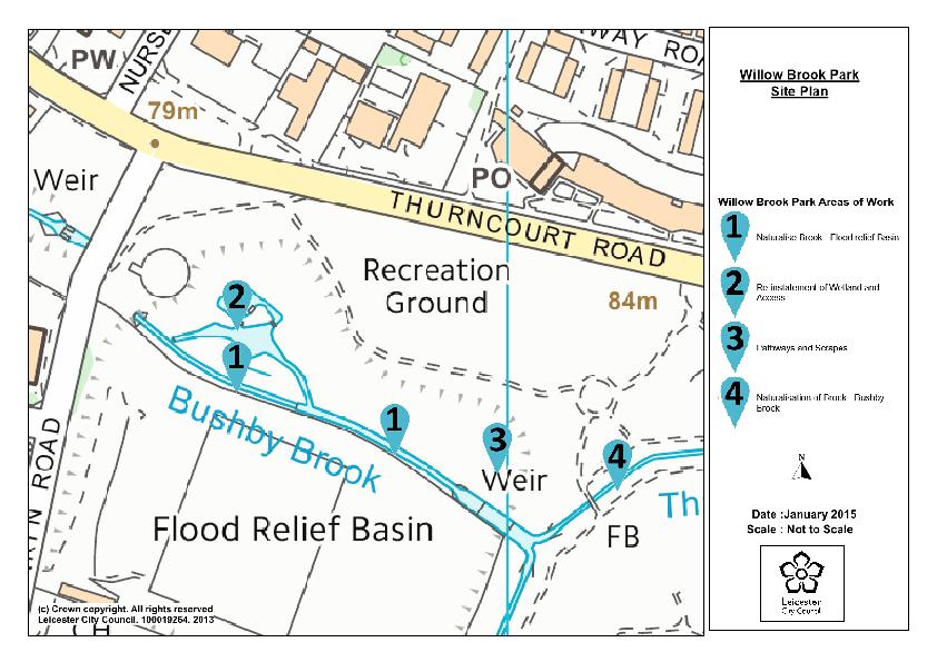
9 3. The Project This Project is divided into a series of smaller-scale projects that make up a larger project. Appendix 1 shows the location of the Projects identified 3.1 Area 1 Naturalise brook flood relief basin Reasons for Project: The brook is largely contained within a linear channel to the north part of the basin. The adjacent area is floodplain and provides a mosaic of habitats. Biodiversity is present but limited in the current channel structure with areas of sediment build-up, causing nutrient enrichment and vegetation that restricts channel flow and requires regular maintenance Solution: Break out banks along the brook and provide soft edge to channel avoid culverted area under Dakyn Road Create series of pools and riffles via meanders and structures to aerate flow, provide micro-habitats and improve visual amenity Plant areas with native aquatic species Page 9

 of varying")

10 3.2 Area 2 Re-instatement of Wetland and Access Reasons for Project: Wetland marsh, willow carr contained within grassy banks provide a habitat in decline due to poor access and difficulty to maintain. The area is not accessible to the public for large parts of the year due to predominant wet conditions. The natural filtration processes are limited as the brook is off-line from the flood basin. Otters regular visit the site and spraint activity recorded but no habitat suitable for them to remain in the area Solution: Excavate out a series of wetland areas (4-6) of varying sizes and depths to create areas of permanent open water, ephemeral areas to enable natural filtration and improve water quality/biodiversity Thin out willow carr, retain wood on-site, create large log piles anchored into place and allowed to rot naturally Create otter holt from materials on site and/or EA otter holt pack Facilitate access across the area through a series of raised causeways, board walk and 2 x small footbridges Create small viewing/dipping platform for use by local schools Page 10


11 3.3 Area 3 Access - Pathways and Scrapes Reasons for Project: Access across the floodplain area is generally poor and difficult to manage effectively. This area leads to the more formal area of the Park and access from shops onto the Park. Encouraging better use of this area and creation of footpath linkages to a wider network of paths would encourage use as well as a safe environment or encourage public awareness of water quality and biodiversity. Solution: Re-profile scrape areas create 1 x larger scrape and deepen to below water table to facilitate some open water throughout the year Re-grade northern sloping bank to provide terraced level walkway at higher level for pedestrian access, compact surface, hard-core and re-seed Re-seed scrape banks with wet grassland seed mix Thin out plantation on top of north bank to encourage light and improve grassland diversity Page 11

12 3.4 Area 4 Naturalise water course Bushby Brook Reasons for Project: Hydro-morphology is a WFD failing indicator of the Willow Brook. The Thurnby Brook and Bushby Brook converge on this upper area of the Park, but are largely channelled through steep-sided earth banks before slowing to cascade over the weir. Regular build-up of sediment and maintenance/clearance around the weir area is required to facilitate flow and reduce flood risk. Major engineering/flood relief works may be planned in the future in this area, but these proposals provide a limited and cost-effective method of improving water quality and biodiversity at a localised level whilst maintaining flood resilience. Solution: Low-key re-grading of earth banks to create a series of shallow meanders; careful design to create to allow natural scouring and create a mini-riffle system to aerate flows and provide micro-habitat and improve visual amenity Create series of deeper pool areas to slow water flow in more accessible areas and provide areas for sediment to be removed Protect bank areas with aquatic planting to facilitate edge protection Page 12
13 4 Costs Area 1 Amount Unit Rate Cost Sub total Willow Brook Nature Area Naturalise brook Re-grade earth banks of brook 170 lin m Create pools and riffles in channel 40 m² Plant with marginal plants 60 m² Area 2 0 Re-instatement of wetland and access 0 Excavate 4 to 6 small wetland areas 70 m² Re-excavate ditch to link from brook into wetland and re-profile 36 lin m Thin-out willow carr plantation 30 m² Create otter holt 1 each Create boardwalk - recycled plastic 95 lin m Viewing/dipping platform 1 each Area Access to Pathways and Scrapes 0 Raised path on sloped bank - stoned surface- allow for regrade slope and form path 60 lin m Re-excavate and enlarge scrape 750 m² Re-excavate ditch to link from brook into wetland and re-profile 20 lin m Take off top soil and remove to agreed area outside floodplain 210 m² Thin-out plantation 125 m² Notes spoil to be kept on site spoil to be kept on site Page 13
14 conservation work to scrub 50 m² 0 Wildflower planting; wet meadow 150 m² Area 4 0 Naturalise Bushby Brook/Thurnby Brook 0 Break out banks along water course 75 lin m Create pools and riffles in channel 30 m² Plant with marginal plants 30 m² x day conservation work Page 14
15 5 Constraints and Timing Planning permission is unlikely to be required as this is dependent on the volumes of materials to be removed and any structural works (banks to be broken out in small sections to enable natural greening of edges only); Agreement from Environment Agency on proposed works and Panel Engineer if the site is considered to be a reservoir during flood conditions. The Panel Engineer will have to approve all works. Local Authority consents for works may be waived as on Local Authority land, but agreement is required Ecology the site is of ecological value see ecology report further surveys required during appropriate season Works proposed will require mitigation measures to minimise impact on watercourse and should take place outside of the bird nesting season (nesting season between March and end August) No trees are to be impacted by the proposed works All works should be scheduled in to cause minimal impact to wildlife Area 1 naturalise brook-flood relief basin works Area 2 Re-instate wetland and access see mitigation works and supervision required Area 3 Access to pathways see mitigation works and supervision required Area 4 and 5 Naturalise water courses further surveys required and see mitigation works and supervision required Page 15
16 Page 16
17 Page 17
18 Extract from Ecology Survey Page 18
Application for resource consent Form B Damming and diversion of water
 Application for resource consent Form B Damming and diversion of water Notes Resource use activities must meet all the conditions of any relevant Permitted Activity Rules in the Waikato Regional Plan or
Water of Leith catchment profile
 catchment profile Introduction The catchment covers a total area of 122 km 2 and predominantly drains the north western slopes of the Pentland Hills from its source in the Colzium springs. The natural
Natural Flood Management. Measures & Multiple Benefits. Steve Rose (JBA)
") Natural Flood Management Measures & Multiple Benefits Steve Rose (JBA) Definitions Natural Flood Management - NFM (SEPA): A range of techniques that aim to reduce flooding by working with natural features
Natural Flood Management Measures & Multiple Benefits Steve Rose (JBA) Definitions Natural Flood Management - NFM (SEPA): A range of techniques that aim to reduce flooding by working with natural features
WATERSHED. Maitland Valley. Report Card 201
 Maitland Valley WATERSHED Report Card 201 The Maitland Valley Conservation Authority has prepared this report card as a summary on the state of our forests, wetlands, surface water, and ground water resources.
How can rivers be managed?
 How can rivers be managed? To be able to identify different management strategies, distinguishing between hard and soft engineering (4-5) To be able to give the advantages and disadvantages of different
Annex F Scoping Checklist
 Scoping Checklist Table F1: Scoping Checklist Table. Questions to be considered in Scoping /? Which Characteristics of the Project 1. Will construction, operation or decommissioning of the Project involve
POLICY FOR NATURAL RESOURCE MANAGEMENT AREAS
 POLICY FOR NATURAL RESOURCE MANAGEMENT AREAS I. POLICY STATEMENT Auburn University's (the University's) "Policy for Natural Resource Management Areas" implements the Campus Master Plan Land Use Element
AP Environmental Science
 AP Environmental Science Types of aquatic life zones MARINE Estuaries coral reefs mangrove swamps neritic zone pelagic zone FRESHWATER lakes and ponds streams and rivers wetlands Distribution of aquatic
Water & Agriculture. Seamus Barron Nitrates, Biodiversity & Engineering Division
 Water & Agriculture Seamus Barron Nitrates, Biodiversity & Engineering Division Presentation overview Water Framework Directive Nitrates regulations Support /initiatives for protecting water quality 2
Eye Water and Berwick coastal catchment profiles
 Eye Water and Berwick coastal catchment profiles These catchment profiles have been produced together because the Eye Water priority catchment work includes water bodies within both catchments, the land
Chapter 10 Natural Environment
 Chapter 10 Natural Environment Existing Conditions The Natural Environment Element addresses the protection, conservation, preservation, and restoration of the natural resources the Bayview Ridge Subarea,
SITE OF SPECIAL SCIENTIFIC INTEREST: MANAGEMENT STATEMENT PEMBROKESHIRE AFON CLEDDAU GORLLEWINOL / WESTERN CLEDDAU RIVER
 CYNGOR CEFN GWLAD CYMRU COUNTRYSIDE COUNCIL FOR WALES SITE OF SPECIAL SCIENTIFIC INTEREST: MANAGEMENT STATEMENT PEMBROKESHIRE AFON CLEDDAU GORLLEWINOL / WESTERN CLEDDAU RIVER Date of Notification: 24 March
ABERDEEN CITY SUSTAINABLE DRAINAGE SYSTEMS (SUDS) AND FLOOD DEFENCES
 AND FLOOD DEFENCES") ABERDEEN CITY SUSTAINABLE DRAINAGE SYSTEMS (SUDS) AND FLOOD DEFENCES Countesswells Avenue, Retention Pond A retention ponds function is for water attenuation (storing and slow release) and treatment. The
ABERDEEN CITY SUSTAINABLE DRAINAGE SYSTEMS (SUDS) AND FLOOD DEFENCES Countesswells Avenue, Retention Pond A retention ponds function is for water attenuation (storing and slow release) and treatment. The
Standards for SWMF s. (Stormwater Management Facilities) Lacombe County s Guide to Developing Stormwater Management Facilities
 Lacombe County s Guide to Developing Stormwater Management Facilities") Standards for SWMF s (Stormwater Management Facilities) Lacombe County s Guide to Developing Stormwater Management Facilities August 2017 PREAMBLE Development results in a great amount of impervious area,
Standards for SWMF s (Stormwater Management Facilities) Lacombe County s Guide to Developing Stormwater Management Facilities August 2017 PREAMBLE Development results in a great amount of impervious area,
Watercourses and Wetlands and Agricultural Activities
 Watercourses and Wetlands and Agricultural Activities Watercourses and regulated wetlands can be found throughout New Brunswick, including on agricultural lands. The Clean Water Act defines a watercourse
FACTSHEET INTRODUCTION. help rebalance the water cycle, mitigate the effects of climate change and improve human health and livelihoods.
 1 FACTSHEET INTRODUCTION World Water Day, on 22 March every year, is about focusing attention on the importance of water. This year s theme, Nature for Water, explores nature-based solutions (NBS) to the
Overview of the Walkover Assessments conducted on the Pont and Blyth catchments
 Overview of the Walkover Assessments conducted on the Pont and Blyth catchments Pont upstream of the Matfen Transfer (08/03/12) Pont, as supplied from the Matfen Transfer. Also an impassable barrier to
Guidance on the Classification of Ecological Potential for Heavily Modified Water Bodies and Artificial Water Bodies
 Guidance on the Classification of Ecological Potential for Heavily Modified Water Bodies and Artificial Water Bodies UKTAG Guidance 31st March 2008 Document title UKTAG Guidance on the Classification of
Environment Agency. Title. POI / Status: For File Storage / Archive Doc Title: Exeter Phase 1 NTS
 Doc Ref: Exeter_FDS_Non_Technical_Summary_Phase_1_Final_Volume_1[1] Exeter Flood Defence Scheme, Phase 1 Volume 1: Non-technical Summary Reference number/code Environment Agency [Sector Code] Title We
Constructed Wetland Pond T-8
 Constructed Wetland Pond T-8 Description A constructed wetlands pond is a shallow retention pond designed to permit the growth of wetland plants such as rushes, willows, and cattails. Constructed wetlands
Hough, M., Stewart, W.I., Uderstadt, K.F. & Wood, A.
 DESIGN, CONSTRUCTION, OPERATION AND EFFECTIVENESS OF A PILOT ARTIFICIAL WETLAND SYSTEM TO REMOVE STORMWATER AND SEWAGE POLLUTANTS ENTERING THE SWARTKOPS RIVER ESTUARY VIA THE MOTHERWELL CANAL, NELSON MANDELA
SCOTTISH ENVIRONMENT PROTECTION AGENCY PREVENTION OF POLLUTION FROM CIVIL ENGINEERING CONTRACTS: GUIDELINES FOR THE SPECIAL REQUIREMENTS
 SCOTTISH ENVIRONMENT PROTECTION AGENCY PREVENTION OF POLLUTION FROM CIVIL ENGINEERING CONTRACTS: GUIDELINES FOR THE SPECIAL REQUIREMENTS Version 2 June 2006 1. Purpose These Guidelines are supplementary
Temporary Watercourse Crossing: Culverts
 Temporary Watercourse Crossing: Culverts DRAINAGE CONTROL TECHNIQUE Low Gradient Velocity Control Short Term Steep Gradient Channel Lining Medium-Long Term Outlet Control Soil Treatment Permanent Symbol
 Good Morning! Bruce Gilman Department of Environmental Conservation and Horticulture Finger Lakes Community College 3325 Marvin Sands Drive Canandaigua, New York 14424 585-785- 1255 gilmanba@flcc.edu Northern
Thames Regional Flood and Coastal Committee (RFCC) Flood risk management and environmental benefits in the Thames River Basin, 2015 to 2021
 Flood risk management and environmental benefits in the Thames River Basin, 2015 to 2021") Thames Regional Flood and Coastal Committee (RFCC) Flood risk management and environmental benefits in the Thames River Basin, 2015 to 2021 1. Thames Region Flood Risk Management Programme 1.1 A 2.3 billion
Thames Regional Flood and Coastal Committee (RFCC) Flood risk management and environmental benefits in the Thames River Basin, 2015 to 2021 1. Thames Region Flood Risk Management Programme 1.1 A 2.3 billion
Lesson 2-2: Riparian Zones
 2-14 Lesson 2-2: Riparian Zones Time of Lesson: 1 hour Rationale: The purpose of this lesson is to define what a riparian zone is and link its importance for fish and other animals, and humans, and the
Improving the condition of Solway Tweed s water environment Tweed area management plan
 Improving the condition of Solway Tweed s water environment Tweed area management plan 2010 2015 Supplementary to the river basin management plan for the Solway Tweed river basin district Page 1 of 20
STREAM AND BUFFER AREA PROTECTION/RESTORATION
 STREAM AND BUFFER AREA PROTECTION/RESTORATION AMENDMENT OPTIONS TO STRENGTHEN POLICY IN HEADWATERS AREAS DRAFT SUBSEQUENT TO THE JANUARY 25, 2007 MEETING OF THE PLANNING COMMISSION ENVIRONMENT COMMITTEE
Danube Facts and Figures. The Czech Republic (July 2007)
") Danube Facts and Figures The (July 2007) General Overview The is situated at the roof of Europe, and its waters are drained through rivers into three different seas. The major part of the territory is
Danube Facts and Figures The (July 2007) General Overview The is situated at the roof of Europe, and its waters are drained through rivers into three different seas. The major part of the territory is
Wetlands Project Guidance
 HABITAT Wetlands Project Guidance Stakeholder Informed Introduction Wetlands are lands saturated with water permanently or seasonally. Wetlands are typically defined by three characteristics: 1) The area
These potential changes and their implications are outlined in Annex 1.
 Guidance Note Hydropower Guidance Note: This Guidance Note has been prepared by Natural Resources Wales (NRW) to provide applicants for abstraction and impoundment licences for hydropower schemes with
Attachment 12 Stage 1 Flood Risk Assessment (IE RP-0001)
") IE0311133-22-RP-0001, Issue A 17/10/2013 Attachment 12 Stage 1 Flood Risk Assessment (IE0311133-30-RP-0001) IE0311133-22-RP-0001_A_02.DOC Flood Risk Assessment Celebrating 40 Years in Business Jazz Pharmaceuticals
IE0311133-22-RP-0001, Issue A 17/10/2013 Attachment 12 Stage 1 Flood Risk Assessment (IE0311133-30-RP-0001) IE0311133-22-RP-0001_A_02.DOC Flood Risk Assessment Celebrating 40 Years in Business Jazz Pharmaceuticals
Implementing Stormwater Management through Split-Flow Drainage Design
 Implementing Stormwater Management through Split-Flow Drainage Design Stuart Patton Echols PhD, ASLA, RLA Assistant Professor - Department of Landscape Architecture 210 Engineering Unit D Center for Watershed
Streamlines V2, n2 (May 1997) A Newsletter for North Carolina Water Supply Watershed Administrators
 A Newsletter for North Carolina Water Supply Watershed Administrators") Page 1 of 5 STREAMLINES A Newsletter for North Carolina Water Supply Watershed Administrators Volume 2, Number 2 May 1997 Non-Point Source (NPS) Pollution This issue of Streamlines provides basic information
Page 1 of 5 STREAMLINES A Newsletter for North Carolina Water Supply Watershed Administrators Volume 2, Number 2 May 1997 Non-Point Source (NPS) Pollution This issue of Streamlines provides basic information
INVESTIGATING YOUR STREAM S DRAINAGE BASIN
 IT S OUR WATER INVESTIGATING YOUR STREAM S STREAM ACTIVITY SUMMARY Using maps, students will determine land uses in the drainage basin of their stream and calculate the approximate percentage of impervious
Department of the Army Permit Application
 Department of the Army Permit Application DA File Number U.S. Army Corps of Engineers Honolulu District Date Received by CEPOH-RO Send Completed Application to: Honolulu District, U.S. Army Corps of Engineers
CONSERVATION OF ENVIRONMENT ENACTMENT 1996 CONSERVATION OF ENVIRONMENT (PRESCRIBED ACTIVITIES) ORDER 1999
 ORDER 1999") (No. JPBN. 1509/27 Vol. II CONSERVATION OF ENVIRONMENT ENACTMENT 1996 CONSERVATION OF ENVIRONMENT (PRESCRIBED ACTIVITIES) ORDER 1999 In exercise of the powers conferred by section 5 of the Conservation
(No. JPBN. 1509/27 Vol. II CONSERVATION OF ENVIRONMENT ENACTMENT 1996 CONSERVATION OF ENVIRONMENT (PRESCRIBED ACTIVITIES) ORDER 1999 In exercise of the powers conferred by section 5 of the Conservation
Environmental Information Worksheet
 Environmental Information Worksheet Water System Owner (Attach additional sheets if necessary) Needs and Alternatives Provide a brief narrative that describes: Current drinking water system needs. Project
SW-74 SERENOVA PRESERVE SITES 2, 3, 4, 8 MITIGATION PLAN
 SW-74 SERENOVA PRESERVE SITES 2, 3, 4, 8 MITIGATION PLAN BACKGROUND INFORMATION Project SWIM? Aquatic Control? Exotic Control? Mitigation Bank? Type No No No No Mitigation Restoration and enhancement Type
South St. Vrain / Hall Meadows Restoration Planning August 20, 2015
 South St. Vrain / Hall Meadows Restoration Planning August 20, 2015 Agenda Introductions Purpose & Goals of Meeting Planning Area Master Plan Restoration Planning: Cost Estimates, Grants, Scope, Timeline
Viridor Waste Management. Proposed Development of an In-Vessel Composting Facility. Land at Exide Batteries, Salford Road, Bolton
 Viridor Waste Management Proposed Development of an In-Vessel Composting Facility Land at Exide Batteries, Salford Road, Bolton Non-Technical Summary January 2009 Introduction Viridor Waste Management
Water Quality and Pollution
 Chapter 6 Water Quality and Pollution Guiding Principles: Chapter 4 details all the guiding principles relevant to the overall management of the Harbour. Whilst all should be given some consideration the
River Restoration in Japan
 River Restoration in Japan Keigo Nakamura, Ph.D Water Environment Research Group Public Works Research Institute Contents What is restoration? History of river restoration in Japan Basics for river restoration
1 General questions on zone and catchment management plans
 1 General questions on zone and catchment management plans 1.1 What is a zone plan? The Waikato region is divided into eight zones. There is a separate, non statutory, zone plan for each one. The key purpose
Erosion & Sedimentation Control Policy
 Issue Date 10/22/2010 Page 1 of 8 Erosion & Sedimentation Control Policy Introduction: Soil erosion is the removal of soil by water, wind, ice or gravity and sediment deposition occurs when the rate of
The Proposed Auckland Unitary Plan (notified 30 September 2013)
") ART 3 REGIONAL AND DISTRICT RULES»Chapter H: Auckland wide rules»4 Natural resources» 4.14 Stormwater management Introduction The roposed Auckland Unitary lan (notified 30 September 2013) This section
ART 3 REGIONAL AND DISTRICT RULES»Chapter H: Auckland wide rules»4 Natural resources» 4.14 Stormwater management Introduction The roposed Auckland Unitary lan (notified 30 September 2013) This section
Carp Creek 2013 Summary Report
 Monitoring Activity in the Carp River Watershed In 2012, Mississippi Valley Conservation Authority (MVCA) worked with Friends of the Carp River (FCR) on a preliminary assessment of the Carp River. This
Enclosed farmland: Arable and Horticultural, Improved and Neutral Grasslands
 executive summary Executive summary 1 Countryside Survey 2000 (CS2000) and the Northern Ireland Countryside Survey 2000 (NICS2000) have been designed to provide detailed information about the habitats
Land Management and Flooding. Where are we now?
 Land Management and Flooding Where are we now? Tarland farmer s workshop Andrea Johnstonova, SEPA The talk will cover Some background information: NFM under the FRM Act Implementation so far and examples
Water Framework Directive Water for Life and Livelihoods
 England and Wales Approach to Implementation UKELA Conference 17th June 2005 Dr Martin Griffiths Environment Agency England and Wales Purpose Prevent deterioration, enhance status of aquatic ecosystems
Working on flood embankments: Essential environmental considerations
 Working on flood embankments: Essential environmental considerations Information for project managers, engineers and contractors When undertaking any work on or adjacent to coastal and estuarine flood
KRISTOPHER J. KRZYSTON, CEI, CEM
 PERMITTING IN NEW JERSEY KRISTOPHER J. KRZYSTON, CEI, CEM Kristopher J. Krzyston Rutgers graduate 1994 B.S. Environmental Planning Certificate in G.I.S. Assistant Division Manager Environmental Science
MARINE POLLUTION DEGRADATION MITIGATION MANAGEMENT IS ESSENTIAL FOR IMPROVING MARINE ENVIRONMENT
 MARINE POLLUTION DEGRADATION MITIGATION MANAGEMENT IS ESSENTIAL FOR IMPROVING MARINE ENVIRONMENT The health of the world s oceans and marine life is degrading rapidly as a result of excess human activities.
DRAINAGE & DESIGN OF DRAINAGE SYSTEM
 Drainage on Highways DRAINAGE & DESIGN OF DRAINAGE SYSTEM P. R.D. Fernando Chartered Engineer B.Sc.(Hons), M.Eng. C.Eng., MIE(SL) Drainage Requirement of Highway Drainage System Introduction Drainage means
Ecological Indicators of Water Resource Pressure. Willie Duncan SEPA Jan 2013
 Ecological Indicators of Water Resource Pressure Willie Duncan SEPA Jan 2013 Outline Methods River Water Resources River Morphology Lakes Water Resources/Morphology Format Improvements over previous methods.
16.0 Water Quality Management Criteria for Developed Land
 October 2003, Revised February 2005 Criteria for Developed Land Page 1 16.1 Introduction 16.0 Water Quality Management Criteria for Developed Land Stormwater quality control is an integral part of any
Welcome to the Boulevard Lake Dam Class Environmental Assessment. Public Information Session #1. June 14, 2016
 Welcome to the Boulevard Lake Dam Class Environmental Assessment Public Information Session #1 June 14, 2016 Boulevard Dam - Overview Built approximately 100 years ago Owned and operated by the City of
SECTION 6 STORMWATER AND LAND DRAINAGE
 SECTION 6 STORMWATER AND LAND DRAINAGE Final Version, Approved September 2003 Section 6 and Land Drainage Contents 6.1 PERFORMANCE STANDARDS... 2 6.1.1 General... 2 6.2 MEANS OF COMPLIANCE... 3 6.2.1 General...
Appendix General Environmental Risk Analysis
 Proposed Solar Power Station Near Moree, NSW (MOREE SOLAR FARM) Appendix Prepared by BP Solar & Walsh Consulting January 011 Background The body of the identifies all significant environmental risks identified
Living Shorelines & Coastal Resiliency: A Consultants Perspective. Presented by: Bethany Bearmore, P.E. Louis Berger
 Living Shorelines & Coastal Resiliency: A Consultants Perspective Presented by: Bethany Bearmore, P.E. Louis Berger Living Shorelines & Coastal Resiliency A Consultants Perspective 1. Why 2. Process 3.
Managing Adaptive REsponses to changing flood risk. Bergen. Haukås Watercourse HAUKUS
 Managing Adaptive REsponses to changing flood risk Bergen. Haukås Watercourse HAUKUS 130405 Developers Long term ownership Wildlife Heritage Environment Water quality Water quantity Emergency planning
SECTION 11: REGULATORY FLOODWAYS
 SECTION 11: REGULATORY FLOODWAYS Contents 11.1. The Floodway... 11-2 11.1.1. The floodway concept... 11-2 11.1.2. Floodway map... 11-2 11.1.3. Floodway permitting... 11-3 11.1.4. Changing the floodway...
ENVIRONMENTAL GUIDELINES FOR PREPARATION OF AN ENVIRONMENT MANAGEMENT PLAN. Environment Protection Authority, ACT May 2009
 ENVIRONMENTAL GUIDELINES FOR PREPARATION OF AN ENVIRONMENT MANAGEMENT PLAN Environment Protection Authority, ACT May 2009 ISBN-13: 978-0-642-60494-1 ISBN-10: 0-642-60494-0 Australian Capital Territory,
Municipal Stormwater Ordinances Summary Table
 APPENDIX F Municipal Ordinances Summary Table Municipality Abington Bryn Athyn Borough Hatboro Borough Ordinance, SALDO Runoff equals pre post Erosion Sediment Control Water Quality Requirements Any which
Methods of Streamflow Analysis
 4 Methods of Streamflow Analysis CHAPTER 4 Streamflow Measurements Danielle M. Andrews Department of Crop and Soil Sciences, The Pennsylvania State University I. INTRODUCTION Perennial carries water all
(this cover page left intentionally blank)
") 4. Siting the Well (this cover page left intentionally blank) 4. Siting the Well Chapter Table of Contents Chapter Table of Contents Chapter Description... 4 Regulatory Requirements Well Siting... 4 Relevant
4. Siting the Well (this cover page left intentionally blank) 4. Siting the Well Chapter Table of Contents Chapter Table of Contents Chapter Description... 4 Regulatory Requirements Well Siting... 4 Relevant
3 Objectives 3 Ob jec tives
 3 Objectives 3 Objectives 3 Objectives 3 Objectives contents Objective number Page 3.1 Ki uta ki tai: mountains to the sea O1-O5 37 3.2 Beneficial use and development O6-O13 38 3.3 Māori relationships
Surface Water and Non-Wetland Surface Waters Delineation and Classification pursuant Chapter F.A.C.
 Surface Water and Non-Wetland Surface Waters Delineation and Classification pursuant Chapter 62-340 F.A.C. What are Waters? 373.019 F.S. Definitions (20) Water or waters in the state means any and all
The EU Water Framework Directive
 The EU Water Framework Directive Why is it important to the recreational boating industry? SEPTEMBER 2004 The EU Water Framework Directive: why is it important to the recreational boating industry? The
Stream Corridor Protection and Adaptive Management Manual. Prepared for the City of Independence, Missouri
 Stream Corridor Protection and Adaptive Management Manual Prepared for the City of Independence, Missouri Rock Creek Independence, Missouri By Patti Banks Associates and Applied Ecological Services, Inc.
Preface. MNR # Queen s Printer for Ontario, 2012 ISBN (PRINT) ISBN (PDF)
 ISBN (PDF)") Preface In 2008, the inter-agency Drainage Act & Section 28 Regulations Team (DART) was established by the Ministry of Natural Resources (MNR) and the Ministry of Agriculture, Food and Rural Affairs (OMAFRA)
Preface In 2008, the inter-agency Drainage Act & Section 28 Regulations Team (DART) was established by the Ministry of Natural Resources (MNR) and the Ministry of Agriculture, Food and Rural Affairs (OMAFRA)
This chapter describes the potential hydrological effects of the Project in terms of:
 19. Hydrology Overview The Project will result in changes to existing hydrology from land use changes and from changes to stream morphology. Hydrological and hydraulic modelling has been undertaken to
MURPHY DRAIN CATCHMENT
 The RVCA produces individual reports for 16 catchments in the Lower Rideau subwatershed. Using data collected and analysed by the RVCA through its watershed monitoring and land cover classification programs,
Information for File # PRH
 Information for File # 2016-02602-PRH Applicant Corps Contact Tom Morley Paul Hauser Address 152 Baker Drive, Redwood Falls, MN 56283 E-Mail Paul.R.Hauser@usace.army.mil Phone 651-290-5357 Primary County
Chapter 21 Stormwater Management Bylaw
 Chapter 21 Stormwater Management Bylaw SECTION 1. PURPOSE The purpose of this Bylaw is to: implement the requirements of the National Pollutant Discharge Elimination System (NPDES) General Permit for Storm
Doyle Park Reconstruction Project Improving Flood Control Facilities to Meet a TMDL
 Doyle Park Reconstruction Project Improving Flood Control Facilities to Meet a TMDL Ann Arbor, Michigan Washtenaw County Drain Commissioner & Malletts Creek Coordinating Committee November, 2007 Janis
MEMORANDUM OF UNDERSTANDING THE FLOW OF THE RIVER THROUGH CIRENCESTER
 1. Introduction MEMORANDUM OF UNDERSTANDING THE FLOW OF THE RIVER THROUGH CIRENCESTER 1.1 The control and distribution of fluvial flow through Cirencester is manually controlled by the operation of sluice
Lower Mission Creek Watershed Status Survey 2002
 Lower Mission Creek Watershed Status Survey 2002 Prepared For: Mosquito Creek Stewardship Society Prepared By: Fernando F. Junqueira, Ph.D. August 16, 2002 North Vancouver, August 16, 2002 ENVIRONMENTAL
Nancy L. Young, Forester USAID/USDA Natural Resources Conservation Service
 Forest Management Nancy L. Young, Forester USAID/USDA Natural Resources Conservation Service Material translated by: Mohammadullah Karimi, Training & Liaison Officer Afghan Conservation Corps Managing
Pennsylvania Stormwater Best Management Practices Manual. Chapter 3. Stormwater Management Principles and Recommended Control Guidelines
 Pennsylvania Stormwater Best Management Practices Manual Chapter 3 Stormwater Management Principles and Recommended Control Guidelines 363-0300-002 / December 30, 2006 Chapter 3 Stormwater Management Principles
Agriculture and the Environment IX, Valuing Ecosystems: Policy, Economic and Management Interactions (2012)
") DELIVERING ECOSYSTEM SERVICES IN NATIONAL TRUST LANDSCAPES: DEVELOPING A LAND CAPABILITY PROCESS KA Hearn 1 and TRE Thompson 2 1 National Trust, Heelis, Kemble Drive, Swindon, Wilts, SN2 2NA, UK, E-mail:
DELIVERING ECOSYSTEM SERVICES IN NATIONAL TRUST LANDSCAPES: DEVELOPING A LAND CAPABILITY PROCESS KA Hearn 1 and TRE Thompson 2 1 National Trust, Heelis, Kemble Drive, Swindon, Wilts, SN2 2NA, UK, E-mail:
Very slight to negligible limitations no special land management practices required.
 Land Capability Classes Land and Soil Capability Class 1 Class 1 Definition Very slight to negligible limitations no special land management practices required. On-site impact of land management practices
INTRODUCTION TO HOBBY FARMING AND WATER QUALITY
 SECTION ONE INTRODUCTION TO HOBBY FARMING AND WATER QUALITY This is a handbook for owners of Hobby Farms - small scale farms operated primarily as a residential lifestyle - to provide their owners with
Environmentally friendly drainage measures The use of two-stage profiles to improve diversity and water quality in agricultural streams
 Environmentally friendly drainage measures The use of two-stage profiles to improve diversity and water quality in agricultural streams European River Restoration Conference 2014, Vienna 27.-29.10.2014,
Characteristics of Land Resources
 Chapter Chapter 1 Characteristics of Land Resources The geology, soils and topography of Woodford County T he geology, soils and topography of an area are important to the community planning process for
CHAPTER 6 ADDITIONAL STANDARDS APPLYING TO SHORELAND AREAS AND PUBLIC WATERS
 CHAPTER 6 ADDITIONAL STANDARDS APPLYING TO SHORELAND AREAS AND PUBLIC WATERS Section 1 Intent. 49 Section 2 Floodplain Requirements 49 Section 3 Water-Oriented Accessory Structures 50 Section 4 Stairways,
Information Paper 10 Waste Water and Sewage Sludge
 DRAFT Consultation Document East Sussex, South Downs and Brighton & Hove Waste and Minerals Development Framework Information Paper 10 Waste Water and Sewage Sludge October 2011 DRAFT Information Paper
E. STORMWATER MANAGEMENT
 E. STORMWATER MANAGEMENT 1. Existing Conditions The Project Site is located within the Lower Hudson Watershed. According to the New York State Department of Environmental Conservation (NYSDEC), Lower Hudson
Design Features of Constructed Wetlands for Nonpoint Source Treatment. September 1995
 Design Features of Constructed Wetlands for Nonpoint Source Treatment September 1995 Brochure written by William W. Jones, School of Public and Environmental Affairs, Indiana University, Bloomington, Indiana.
WETLANDS AND OPEN WATERS Compensatory Mitigation Definitions of Factors
 Adverse effects as used in this section of the SOP means any adverse ecological effect on wetlands or areas of open water. Those effects, or impacts, include filling, excavating, flooding, draining, clearing,
Filter Tube Barriers (Instream)
") Filter Tube Barriers (Instream) INSTREAM PRACTICES Flow Control No Channel Flow Dry Channels Erosion Control Low Channel Flows Shallow Water Sediment Control High Channel Flows Deep Water Symbol Photo
Filter Tube Barriers (Instream) INSTREAM PRACTICES Flow Control No Channel Flow Dry Channels Erosion Control Low Channel Flows Shallow Water Sediment Control High Channel Flows Deep Water Symbol Photo
UNIVERSITY OF OREGON NORTH CAMPUS CONDITIONAL USE PERMIT PROJECT Draft Conditional Use Permit Stormwater, Sanitary Sewer, and Water Analysis Report
 UNIVERSITY OF OREGON NORTH CAMPUS CONDITIONAL USE PERMIT PROJECT Draft Conditional Use Permit Stormwater, Sanitary Sewer, and Water Analysis Report Prepared for: Cameron McCarthy Landscape Architects LLP
A. EXECUTIVE SUMMARY. 1. Water status management. 1.1 Water status
 A. EXECUTIVE SUMMARY 1. Water status management 1.1 Water status Data and analyses of water status indicators suggest that the water resources in Croatia are subject to the impact of human activities.
RMB Chivenor Flood Defence Scheme. Non-Technical Summary FINAL. Version 3.0
 RMB Chivenor Flood Defence Scheme Non-Technical Summary FINAL Version 3.0 RMB CHIVENOR FLOOD DEFENCE SCHEME ENVIRONMENTAL STATEMENT CONTENTS 1 INTRODUCTION AND BACKGROUND II 2 THE PROPOSED PROJECT III
WATER CODE TITLE 2. WATER ADMINISTRATION SUBTITLE D. WATER QUALITY CONTROL CHAPTER 26. WATER QUALITY CONTROL SUBCHAPTER A. ADMINISTRATIVE PROVISIONS
 WATER CODE TITLE 2. WATER ADMINISTRATION SUBTITLE D. WATER QUALITY CONTROL CHAPTER 26. WATER QUALITY CONTROL SUBCHAPTER A. ADMINISTRATIVE PROVISIONS Sec. 26.001. DEFINITIONS. As used in this chapter: (1)
12/9/2011. Constructed Wetlands. Functions, Design Criteria
 Constructed Wetlands Functions, Design Criteria 1 2 Functions of Wetlands Flood mitigation Water filtration/purification (treatment) Wildlife habitat, biodiversity Biogeochemical cycles Recreation Reasons
E7. Taking, using, damming and diversion of water and drilling
 E7. Taking, using, damming and diversion of water and drilling E7.1. Introduction Taking, using, damming and diversion of surface water and groundwater provisions in this plan apply in accordance with
CHAPTER 3 Environmental Guidelines for WATERCOURSE CROSSINGS GOVERNMENT OF NEWFOUNDLAND AND LABRADOR DEPARTMENT OF ENVIRONMENT AND LABOUR
 GOVERNMENT OF NEWFOUNDLAND AND LABRADOR DEPARTMENT OF ENVIRONMENT AND LABOUR CHAPTER 3 Environmental Guidelines for WATERCOURSE CROSSINGS WATER RESOURCES MANAGEMENT DIVISION Water Investigations Section
Adaptation planning at different spatial scales
 Adaptation planning at different spatial scales Using TCPA Publication Adaptation by Design as the main source GerGerry Metcalf UKCIP UKCIP Key adaptation principles for planning UKCIP Seek opportunities