Ottawa-Trussler Area Sewage Facility Class Environmental Assessment
|
|
|
- Arron Rogers
- 6 years ago
- Views:
Transcription
1 Welcome to the Ottawa-Trussler Area Sewage Facility Class Environmental Assessment Public Open House May 7, 2013 September 25, 2013
2 Welcome The purpose of this second Public Open House is to: Present the study objectives and study area Confirm the alternative solutions taken forward for evaluation Discuss the potential environmental effects of the alternatives Summarize the results of the evaluation of alternatives Obtain feedback on the preliminary preferred alternative Highlight the next steps in the EA process Public Open House #1 was held on May 7, No public or agency comments were received following the open house.

3 Problem/Opportunity Statement To support the development of the Laurentian West Phase 3b Community and surrounding area, sanitary sewage servicing is being planned. Servicing may require a pumping station, forcemain, and downstream upgrades to convey the flow.

4 Project Objectives Identify alternatives for wastewater collection and pumping Identify alternatives for forcemain and routing Review the downstream capacity of existing sanitary collection system and the Borden Trunk Recommend collection, pumping capacity, pumping station location and forcemain route, and any upgrades required in the existing Protect the environment, as defined in the Environmental Assessment Act, through the wise management of resources. This objective will be met through monitoring, mitigation, and extensive consultation with all affected and interested parties Involve the participation of a broad range of stakeholders in the study through a variety of methods including public notices, local newspaper advertisements and open houses downstream collection system

5 Revised Study Area During the development of alternatives it was determined that a larger study area was needed to account for potential infrastructure and associated environmental impacts. The following areas were subsequently incorporated within the revised study area: Mannheim Estates Areas to the north and south of Ottawa Street, west of David Bergey Drive
6 Class EA Process Under current provincial legislation, the planning and design of municipal water and wastewater projects must be in accordance with Ontario Environmental Assessment Act. The Municipal Class EA describes the process that proponents (in this case, City of Kitchener) must follow to meet the requirements of the Act, which includes public consultation. This project is identified as a Schedule B project and includes two Public Open Houses. This process reflects the following key principles: Consideration of a reasonable number of alternatives, including the "do nothing" alternative. Consultation with all affected parties, including the public, relevant governmental review agencies, other affected municipalities and utility companies. Identification and consideration of the effects of each alternative on all aspects of the environment, i.e. the impact on the natural, social, cultural, technical and economic/financial environment. Systematic evaluation of alternatives in terms of their advantages and disadvantages with respect to all aspects of the environment. Provision of clear and complete documentation of the planning process followed, to allow "traceability" of decision-making with respect to the project.
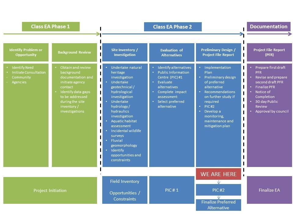
7 EA Phases


8 Evaluation of Alternatives Further analysis of the proposed alternatives presented in the first Open House led to Alternatives 3 and 6 being discounted Alternative 3 - discounted from further assessment. The defining characteristic of Alternatives 3 and 6 was the development of a new pumping station on Trussler Road. This is not considered to be feasible for the following reasons: Site constraints Future development of Trussler Road Alternative 6 - discounted Installation of a major new Union Gas natural gas pipeline along Trussler Road Ability to accommodate the proposed subdivision design As a result, only Alternatives 1, 2, 4 and 5 were taken forward for evaluation.


9 Evaluation of Alternatives Alternative 1: Alternative 2: Alternative 4: Alternative 5: Do Nothing New pumping station in Activa Trussler North Subdivision Existing Mannheim Estates Pumping Station & Forcemain to be upgraded to pump to new pumping station & abandon forcemain on Ottawa St No servicing to support future development Existing servicing would remain as is New pumping station in Activa Trussler North Subdivision Existing Mannheim Estates Pumping Station & Forcemain unchanged New gravity sewer from Activa Trussler North Subdivision along Trussler Rd to Existing Mannheim Estates system Existing Mannheim Estates Pumping Station upgraded Alternative 2-A Alternative 4-A New forcemain through Activa Trussler North Subdivision Alternative 2-B New forcemain along Trussler Rd & Ottawa St New forcemain through Activa Trussler North Subdivision & abandon forcemain on Ottawa St Alternative 5-A New forcemain through Activa Trussler North Subdivision Alternative 4-B Alternative 5-B New forcemain along Trussler Rd & Ottawa St New forcemain along Trussler Rd and Ottawa St
10 Evaluation Process Detailed Evaluation Criteria were developed in consultation with the City and the public for the following categories: Natural Environment Socio-Cultural Environment Construction / Financial / Technical Discipline specialists in ecology, planning, engineering, cultural heritage and archaeology undertook a comparative evaluation of the alternatives scoring each alternative based upon its likely potential environmental impacts (from most preferred to least preferred). Most Preferred Least Preferred The evaluation matrix clearly identifies a preferred alternative solution. The Do Nothing Alternative is used in the evaluation as a benchmark by which to evaluate viable Alternatives. Crucially, the Do Nothing does not address the study objectives or wider growth objectives of the City, and therefore cannot be considered the preferred alternative.
11 Evaluation Criteria
")

 Eastern Meadowlark (threatened;")
 Eastern Ribbonsnake (special concern; potential habitat) Snapping")
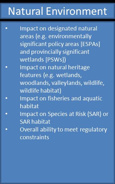
12 Natural Environment Features Designated Natural Heritage Areas in the study area: A portion of Laurentian West Wetland Complex (Locally Significant Wetland) Three forested areas mapped as core areas in the Regional Official Plan Greenlands Network Seven small unevaluated wetland pockets in the study area Species at Risk (SAR) or SAR habitats in the study area: Barn Swallow (threatened; confirmed presence flyover only) Eastern Meadowlark (threatened; confirmed presence potential habitat) Milksnake (special concern; potential habitat) Eastern Ribbonsnake (special concern; potential habitat) Snapping turtle (special concern; confirmed habitat)
13 Natural Environment Potential Effects Impact on designated natural areas: Negligible difference between Alternatives 2, 4 and 5 Potential for sediment release into the adjacent Locally Significant Wetland if the forcemain is constructed on the south side of Ottawa St No impacts during regular operation low risk of forcemain rupture and release of sewage into Laurentian West Wetland Complex Impact on natural heritage features: Negligible difference between Alternatives 2, 4 and 5 Pumping station will remove a portion of a hedgerow and cultural vegetation mosaic Forcemain installation will require temporary disturbance of roadside cultural meadow No impacts during regular operation Impact on fisheries and aquatic habitat: Negligible difference between Alternatives 2, 4 and 5 Potential for sediment release into pond (assumed fish habitat) if forcemain is constructed on the south side of Ottawa Street No impacts during regular operation low risk of forcemain rupture and release of sewage into fish habitat (part of Locally Significant Wetland) Impact on Species at Risk (SAR) or SAR habitat: Negligible difference between Alternatives 2, 4 and 5 Potential for sediment release into adjacent Locally Significant Wetland if forcemain is constructed on the south side of Ottawa Street Potential SAR turtle injury/mortality risk if construction is conducted during hibernation period no in-water works or works that may alter water levels within the Locally Significant Wetland or adjacent stormwater management pond should be conducted from October to April Potential SAR turtle injury/mortality risk if turtles enter construction zone wildlife fencing will be installed prior to construction No impacts during regular operation low risk of forcemain rupture and release of sewage into Laurentian West Wetland Complex Overall ability to meet regulatory constraints: Negligible difference between Alternatives 2, 4 and 5 For all Alternatives, the Locally Significant Wetland provides protected habitat for Blanding s turtle this species is designated as Threatened under the Endangered Species Act A permit or registration may be required
14 Natural Environment Evaluation Results Alternative 1 Alternative 2 Alternative 4 Alternative 5 Do Nothing 2A 2B 4A 4B 5A 5B Impact on designated natural areas (e.g. ESPAs and PSWs) during construction and operation Impact on natural heritage features (e.g. wetlands, woodlands, valleylands, wildlife and wildlife habitat) during construction and operation Impact on fisheries and aquatic habitat during construction and operation Impact on Species at Risk (SAR) or SAR habitat during construction and operation Overall ability to meet regulatory constraints Excluding the Do Nothing, there is a negligible difference from a natural environment perspective between Alternatives 2, 4 and 5.
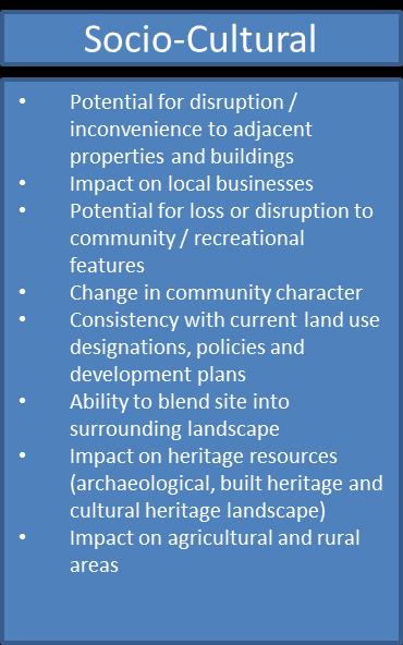
15 Socio-Cultural Environment Potential Effects Potential for disruption/inconvenience to adjacent properties and buildings: Alternative 2A performs marginally better than Alternatives 2B, 4 and 5 All Alternatives have minor/temporary disruption to adjacent properties accessed from Ottawa Street during construction Additional minor/temporary disruption to adjacent properties within Mannheim Estates for Alternatives 4 and 5 during construction Impact on local businesses: No impact during construction or regular operation as the surrounding area is primarily residential Potential for loss or disruption to community/recreational features: No loss or disruption associated with Alternative 2 Potential minor/temporary disruption and loss of adjacent parkland in Alternatives 4 and 5 if existing Mannheim Estates Pumping Station is expanded Change in community character: No change in community character for all Alternatives Consistency with current land use designations, policies and development plans: Do Nothing does not support wider growth policies, plans and objectives for the City All other Alternatives are consistent with land use designations and development policies Ability to blend into surrounding landscape: Alternative 2 new pumping station will have a minor visual impact but can be designed to blend into proposed landscape within the subdivision Alternative 4 may have minor visual impact to existing landscape depending on the extent of the upgrade to the existing Mannheim Estates Pumping Station Alternative 5 combination of a new pumping station and upgrade to the existing Mannheim Estates Pumping Station will have a marginally greater visual impact Impact on heritage resources The impact to archaeological and built heritage resources is considered to be low for all Alternatives Impact on agricultural and rural areas The surrounding area is designated as an urban area and will be developed for residential land use; therefore none of the Alternatives will have an impact
16 Socio-Cultural Environment Evaluation Results Alternative 1 Alternative 2 Alternative 4 Alternative 5 Do Nothing 2A 2B 4A 4B 5A 5B Potential for disruption/inconvenience to adjacent properties and buildings during construction Potential for disruption/inconvenience to adjacent properties and buildings during operation Impact on local businesses during construction and operation Potential for loss or disruption to community/recreational features during construction and operation Change in community character Consistency with current land use designations, policies and plans Ability to blend into surrounding landscape Impact on heritage resources during construction and operation Impact on agricultural and rural areas during construction and operation Excluding the Do Nothing, Alternative 2A is the preferred alternative from a socio-cultural environment perspective.

17 Construction Potential Effects and Evaluation Results Ease of excavation and need for dewatering during construction: Alternatives 2A and 5A are both located in greenfield sites within the proposed development and involve the minimum level of linear works Potential for disruption to local traffic during construction: Alternatives 2A and 5A linear works are largely limited to within a greenfield site and along Ottawa Street South Potential for noise, dust and vibration during construction: Alternative 2A is located within a greenfield site with the minimum level of linear works along Ottawa Street South Construction constraints (e.g. permitting requirements and land acquisition) Alternative 2A is located within a greenfield site within the proposed development and within the existing Ottawa Street South right-of-way Impact on existing utilities and services (e.g. mains sewers, gas, electric) Alternatives 2A and 5A involve the minimum level of linear works and will be connected to new utilities and services
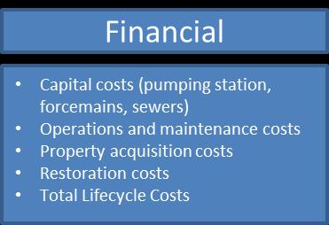
: Alternative 2A requires the lowest capital costs as the pumping station will be located within a greenfield site and the forcemain will require the minimum level")
18 Financial Potential Effects and Evaluation Results Capital costs (e.g. pumping station, forcemain, sewers): Alternative 2A requires the lowest capital costs as the pumping station will be located within a greenfield site and the forcemain will require the minimum level of linear works Alternative 2A estimated to cost approx. $3.5 million; Alternative 4B (highest capital costs) estimated to cost approx. $4.9 million Operations and maintenance costs: Alternative 2 requires the lowest operations and maintenance costs as only one pumping station and forcemain will be operated Property acquisition costs: Alternatives 2 and 5 are located within the proposed development with no requirement for property acquisition Restoration costs: Alternatives 2A and 5A require the minimum level of infrastructure Total Lifecycle Costs: Alternative 2A requires the lowest capital and operating costs compared to other Alternatives Capital Costs (Millions) $3.5 $4.0 $4.5 $4.9 $3.7 $4.2

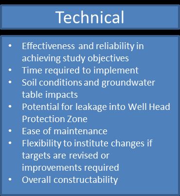
19 Technical Potential Effects and Evaluation Results Effectiveness and reliability in achieving study objectives: The Do Nothing does not support the study objectives; all other Alternatives are supportive Time required to implement: Alternative 2 will be implemented by the City and developer without additional approvals Soil conditions and groundwater table impacts: All Alternatives involve deep excavations, forcemain trenching and dewatering to be carefully controlled in accordance with the geotechnical investigation recommendations Potential for leakage into Well Head Protection Zone: Alternative 4 is located furthest from the Well Head Protection Zone Potential for noise and/or odour emissions during operation: There is a negligible difference between all Alternatives Ease of maintenance: Alternative 4 consolidates maintenance at a single pumping station and forcemain Flexibility to institute changes if targets revised or improvements required: Alternatives 2 and 5 utilize infrastructure that is able to support future changes Overall constructability: Alternative 2A is within a greenfield site and the proposed development and involves the minimum level of linear works


20 Preferred Alternative 2A Alternative 1 Do Nothing Alternative 2 2A 2B Alternative 4 4A 4B Alternative 5 5A OVERALL Overall, the preferred alternative is Alternative 2A as it scores comparatively better than other Alternatives across all criteria. Pumping Station Site Development This is a visual rendering for illustrative purposes only and may be modified during detailed design 5B

21 Preferred Alternative 2A
22 Preferred Alternative 2A Minimum impacts for: Socio-Cultural Environment no loss of existing community or recreational features and minimal disruption and inconvenience for local residents Construction main site and forcemain is through a greenfield site and has the shortest forcemain length through an existing right-of-way; minimal impacts related to noise and vibration, traffic control and existing utilities Financial shortest forcemain length through an existing right-of-way; lowest capital investment, operations/maintenance costs and Total Lifecycle Costs Technical overall is the technically preferred alternative; requires the least time to implement and provides flexibility to institute changes if targets are revised or future improvements are required
23 Mitigation Strategies Mitigation strategies may include: Constrain pipeline construction and staging within existing Ottawa Street South right-of-way Where required, to minimize dewatering and the excavation footprint, employ sheet pile and/or close coupled caisson walls during construction Siltation control fencing and filter bags or settling ponds for pumped groundwater control during construction Traffic safety assessment to address flow/congestion issues during construction


24 Mitigation Strategies Stabilize and re-vegetate exposed surfaces as soon as possible retain natural vegetation cover where possible to provide erosion control GRCA and Agency approvals will be obtained as required During Detailed Design - follow MOE s Guideline B-6 Guidelines for Evaluating Construction Activities Impacting on Water Resources and any other applicable municipal and Conservation Authority regulations Design and construct noise and odour emission controls to meet site specific and MOE requirements
25 Next Steps There will be a two-week commenting period following this Open House The draft ESR will be presented to Council for approval in October/November 2013 Finalize ESR in November 2013 File the ESR with MOE for a 30-day public and agency review period in November 2013 Providing no Part II Order is requested, the EA will be deemed complete at the end of December 2013 and the project may proceed to implementation (Phase 5 the final phase of the Class EA process)
26 Contact Info Should you have any questions or wish to forward comments please contact: Mr. Trevor Jacobs, C.E.T. Project Manager Mr. Mani Ruprai, P.Eng. Manager, Infrastructure & Environment MMM Group Limited Development Engineering City of Kitchener 200 King Street W, PO Box 1118 Kitchener, ON N2G 4G7 Contact: Mr. James Jarrett, MSci, MCIP, RPP Environmental Planner Planning & Environmental Design Telephone: x MMM Group Limited 100 Commerce Valley Drive West Thornhill, ON L3T 1A0 Telephone: x6113 THANK YOU FOR ATTENDING
GRAND NIAGARA Proposed Secondary Plan
 GRAND NIAGARA Proposed Secondary Plan Public Open House #3 January 17. 2017 scope + process BUILT Grand Niagara Secondary Plan The Grand Niagara Secondary Plan will establish a framework for the future
Welcome. Public Information Event. Dufferin Sanitary Trunk Sewer (STS) System Improvements Municipal Class Environmental Assessment Study
 System Improvements Municipal Class Environmental Assessment Study") Welcome Public Information Event Dufferin Sanitary Trunk Sewer (STS) System Improvements Municipal Class Environmental Assessment Study Please sign in to be added to the study mailing list and receive
Welcome Public Information Event Dufferin Sanitary Trunk Sewer (STS) System Improvements Municipal Class Environmental Assessment Study Please sign in to be added to the study mailing list and receive
Sustainable Halton Water & Wastewater Master Plan. Public Information Centre #1
 Sustainable Halton Water & Wastewater Master Plan Public Information Centre #1 Welcome to Public Information Centre #1 Please sign in on the sheet provided. Our representatives will be pleased to discuss
Public Information Centre No. 2
 Public Information Centre No. 2 Wednesday April 20, 2011 4:00 pm to 7:00 pm City of Welland City Hall Area 2 Welland, Pelham, and Port Colborne Welcome to Public Information Centre No. 2 Please sign in
ENVIRONMENT ACT TERMS OF REFERENCE NOVA SCOTIA DEPARTMENT OF TRANSPORTATION AND PUBLIC WORKS. Beaver Bank Bypass
 ENVIRONMENT ACT TERMS OF REFERENCE NOVA SCOTIA DEPARTMENT OF TRANSPORTATION AND PUBLIC WORKS Beaver Bank Bypass Highway 101 to the Beaver Bank Road Halifax County, NS NOVA SCOTIA DEPARTMENT OF THE ENVIRONMENT
WELCOME. Please sign in Representatives are available to answer questions Please complete a comment sheet
 WELCOME Please sign in Representatives are available to answer questions Please complete a comment sheet Place it in the box or send it to the Consultant undertaking the study or to the Town of Wasaga
Preferred Elevated Tank Site
 Preferred Elevated Tank Site Preferred Site No. 3 is on private property owned by Hopewell Developments. Approximately 5 acres of land will be required, including lands required for a permanent access
Airport Road from 1 km North of Mayfield Road to 0.6 km North of King Street Public Information Centre #1
 Municipal Class Environmental Assessment Airport Road from 1 km North of Mayfield Road to 0.6 km North of King Street Public Information Centre #1 Date: Thursday, June 20, 2013 Time: 6:30 p.m. 8:30 p.m.
Factor Potential Effects Mitigation Measures
 Natural Environment No impacts of provincial significance to the natural environment are anticipated for the rapid transit project. Other impacts and how they will be mitigated are outlined in the table
Shell Quest Carbon Capture and Storage Project. Shell Canada Limited
 SCREENING SCOPING DOCUMENT For the proposed Shell Quest Carbon Capture and Storage Project Shell Canada Limited Prepared by: Canadian Environmental Assessment Agency Natural Resources Canada Fisheries
COLE ENGINEERING GROUP LTD.
 CITY OF MARKHAM PROJECT FILE Stormwater Management Facilities Retrofit Municipal Class EA ES12-0316 COLE ENGINEERING GROUP LTD SEPTEMBER 2015 [ Month Year ] HEAD OFFICE 70 Valleywood Drive Markham, ON
The Don River and Central Waterfront are among the most degraded waterways in the City of Toronto.
 This document was put together following the fourth round of public consultation for the Class Environmental Assessment study for this Project. In June 2011, the Project Team consulted with stakeholders
Leaside to Main Infrastructure Refurbishment Project Strengthening the transmission system in your neighbourhood
 Leaside to Main Infrastructure Refurbishment Project Strengthening the transmission system in your neighbourhood Purpose of this Public Information Centre Provide you with an update on Hydro One s infrastructure
Works, services and infrastructure code
 9.4.11 Works, services infrastructure code 9.4.11.1 Application (1) This code applies to assessable development identified as requiring assessment against the Works, services infrastructure code by the
Provincial Policy Statement 2014 Training Aid
 This job aid has been developed for education and training purposes as a high-level summary of the policy changes in the PPS 2014. It should not be relied upon as a substitute for specialized legal or
Environmental Information Worksheet
 Environmental Information Worksheet Water System Owner (Attach additional sheets if necessary) Needs and Alternatives Provide a brief narrative that describes: Current drinking water system needs. Project
Municipality of Kincardine Kincardine Business Park (KBP) Servicing Master Plan
 Servicing Master Plan") Municipality of Kincardine Kincardine Business Park (KBP) Servicing Master Plan Public Meeting and Open-House March 27, 2013 Agenda The Master Plan Process History of the Area Draft Servicing Strategy
Municipality of Kincardine Kincardine Business Park (KBP) Servicing Master Plan Public Meeting and Open-House March 27, 2013 Agenda The Master Plan Process History of the Area Draft Servicing Strategy
Natural Environment Existing Conditions Terrestrial
 Natural Environment Existing Conditions Terrestrial Alternative 1 Significant Woodland in the Southeast and Southwest Woodlots. Significant Wildlife Habitat (SWH) in the Southeast and Southwest Woodlots
DECISION MEMO. West Fork Blacktail Deer Creek Hardened Crossing
 Page 1 of 6 Background DECISION MEMO USDA Forest Service Madison Ranger District Madison County T12S, R4W, Section 30 The project is in the Gravelly Landscape, Snowcrest Recommended Wilderness Management
The Ministry of Natural Resources and Forestry and Municipal Planning Lake Links
 The Ministry of Natural Resources and Forestry and Municipal Planning Lake Links October 21, 2017 Lyn Garrah District Planner MNRF 1 Kemptville Presentation Outline Ontario s Planning System MNRF s role
407 TRANSITWAY. Planning & Preliminary Design
 FROM EAST OF HIGHWAY 400 TO KENNEDY ROAD GWP #252-96-00 Public Information Centre #2 June 24 th and 29 th, 2010 Purpose of Public Information Centre #2 The first Public Information Centre (PIC #1) was
Municipal Class Environmental Assessment for Pottersburg Creek Slope Stability Study South of Hamilton Road, Schedule B
 Municipal Class Environmental Assessment for Pottersburg Creek Slope Stability Study South of Hamilton Road, Schedule B February 13, 2013 Municipal Class EA Process We are here Purpose and Objective of
Welcome to the Boulevard Lake Dam Class Environmental Assessment. Public Information Session #1. June 14, 2016
 Welcome to the Boulevard Lake Dam Class Environmental Assessment Public Information Session #1 June 14, 2016 Boulevard Dam - Overview Built approximately 100 years ago Owned and operated by the City of
LAND DEVELOPMENT AND PLANNING FORUM 2014 THE 2014 PROVINCIAL POLICY STATEMENT AND ENVIRONMENTAL PROTECTION
 LAND DEVELOPMENT AND PLANNING FORUM 2014 THE 2014 PROVINCIAL POLICY STATEMENT AND ENVIRONMENTAL PROTECTION MARY L. FLYNN-GUGLIETTI AND ANNIK FORRISTAL THE 2014 PROVINCIAL POLICY STATEMENT & ENVIRONMENTAL
Welcome to the Public Information Centre. Red Hill Business Park South Transportation Master Plan Addendum. June 25, :00 p.m. to 8:00 p.m.
 Welcome Welcome to the Transportation Master Plan Addendum June 25, 2012 6:00 p.m. to 8:00 p.m. Please sign-in Background In 2006 the City of Hamilton completed the North Glanbrook Industrial Business
Comprehensive Study Scoping Document. for Lower Mattagami Hydroelectric Complex Redevelopment CEAR Reference Number:
 Comprehensive Study Scoping Document for Lower Mattagami Hydroelectric Complex Redevelopment CEAR Reference Number: 07-03-26302 Prepared pursuant to Subsection 21(1) of the Canadian Environmental Assessment
Environmental Assessment Matrix
 For FCC Use Only Date: Customer Name: Environmental Assessment Matrix Loan Number: Please complete each question. Some answers may require additional information. Attach additional documentation where
Sunnyside Heights (Grandview Heights Area #2) Neighbourhood Concept Plan (NCP) - Engineering Servicing and Financial Strategies
 Neighbourhood Concept Plan (NCP) - Engineering Servicing and Financial Strategies") CORPORATE REPORT NO: R236 COUNCIL DATE: November 15, 2010 REGULAR COUNCIL TO: Mayor & Council DATE: November 10, 2010 FROM: General Manager, Engineering FILE: 6520-20 (GH#2) SUBJECT: Sunnyside Heights
CORPORATE REPORT NO: R236 COUNCIL DATE: November 15, 2010 REGULAR COUNCIL TO: Mayor & Council DATE: November 10, 2010 FROM: General Manager, Engineering FILE: 6520-20 (GH#2) SUBJECT: Sunnyside Heights
Report for Agenda Item: 2
 QLDC Council 28 September 2017 Department: Planning & Development Report for Agenda Item: 2 Stage 2 Proposed District Plan Notification Purpose The purpose of this paper is to present those parts of Stage
Regional District of Okanagan-Similkameen 101 Martin Street Penticton, BC V2A 5J9. November 2008 Project No
 Sawmill Road Area Sanitary Sewer Feasibility Study Regional District of Okanagan-Similkameen 101 Martin Street Penticton, BC V2A 5J9 November 2008 Project No. 104258 Table of Contents SECTION TITLE PAGE
SCHOOL SITE SELECTION GUIDE
 SCHOOL SITE SELECTION GUIDE Ministry of Education Province of British Columbia 7 Preface The Ministry of Education School Site Selection Guide has been developed by the School Finance and Capital Planning
TES Industrial Development SW ¼ SEC Lacombe County Outline Plan
 TES Industrial Development Lacombe County Outline Plan 112849297 June 2012 am v:\1128\active\112849297\07_reports_studies\rpt_tes_20120508.doc i Table of Contents 1.0 INTRODUCTION... 1 1.1 PURPOSE... 1
GUIDE TO THE DEVELOPMENT OF A MINING AND RECLAMATION PLAN IN NEW BRUNSWICK
 PROVINCE OF NEW BRUNSWICK DEPARTMENT OF ENERGY AND RESOURCE DEVELOPMENT Minerals and Petroleum Development Branch GUIDE TO THE DEVELOPMENT OF A MINING AND RECLAMATION PLAN IN NEW BRUNSWICK Guide to the
William Rutley Solar Park
 Welcomes You to the First Public Meeting for the William Rutley Solar Park September 9, 2010 6:00-8:30 pm Senior Support C entre 12 Memorial Square, Ingleside, O ntario Your Opinion is important to us,
City of Ottawa. Environmental Impact Statement Guidelines. 2 nd Edition April 2012
 DOCUMENT 1 City of Ottawa Environmental Impact Statement Guidelines 2 nd Edition April 2012 Planning and Infrastructure Portfolio Planning and Growth Management Department Policy Development and Urban
Appendix General Environmental Risk Analysis
 Proposed Solar Power Station Near Moree, NSW (MOREE SOLAR FARM) Appendix Prepared by BP Solar & Walsh Consulting January 011 Background The body of the identifies all significant environmental risks identified
Northern Frontier Northern Homeland
 Northern Frontier Northern Homeland THE REPORT OF THE MACKENZIE VALLEY PIPELINE INQUIRY Volume Two Terms and Conditions Mr. Justice THOMAS R. BERGER ii NORTHERN FRONTIER, NORTHERN HOMELAND - Mackenzie
Chapter 10 Natural Environment
 Chapter 10 Natural Environment Existing Conditions The Natural Environment Element addresses the protection, conservation, preservation, and restoration of the natural resources the Bayview Ridge Subarea,
WATERSHED. Maitland Valley. Report Card 201
 Maitland Valley WATERSHED Report Card 201 The Maitland Valley Conservation Authority has prepared this report card as a summary on the state of our forests, wetlands, surface water, and ground water resources.
CHAPTER 9 DISCUSSIONS, CONCLUSIONS, AND RECOMMENDATIONS
 CHAPTER 9 DISCUSSIONS, CONCLUSIONS, AND RECOMMENDATIONS This chapter summarizes the results of feasibility level investigations undertaken to identify solutions to the water and related land resource problems
Provincial Policy Statement 2014
 Natural Heritage Provincial Policy Statement 2014 NATURAL HERITAGE Nature is bountiful. It is also fragile and finite. Provincial Natural Heritage 0 Interest: Ontario s natural heritage resources are valuable
6 Risk assessment methodology
 Risk assessment methodology 6 Risk assessment methodology 6.1 Introduction INPEX has committed to a systematic risk assessment process as a means of achieving best practice in environmental management
Design Specifications & Requirements Manual
 Design Specifications & Requirements Manual 10 SEDIMENT AND EROSION CONTROL 10.1 INTRODUCTION... 1 10.2 REFERENCE... 1 10.3 GENERAL INFORMATION REQUIREMENTS... 1 10.3.1 ESC Plan... 1 10.3.2 Servicing Drawings...
Chapter 13: Wildlife and Vegetation
 Chapter 13: Wildlife and Vegetation Introduction and Setting Nevada County contains an extremely wide range of plants, animals and habitat types. With topographic elevations ranging from 300 feet in the
Canadian Solar Developers Ltd.
 Canadian Solar Developers Ltd. Type of Document Draft Report Project Name Proposed Ground Mount Solar Facility L.P #5 8338 Scotchmere Drive, Strathroy, ON OPA FIT Program: FIT-FL67GB5 Project Number V00002250-00
STATE OF MINNESOTA MINNESOTA POLLUTION CONTROL AGENCY
 STATE OF MINNESOTA MINNESOTA POLLUTION CONTROL AGENCY In the Matter of the Decision on the Need for an Environmental Impact Statement for the Proposed Remer Wastewater Treatment Facility Expansion FINDINGS
Provincial. Statement
 Provincial Statement This publication was produced by the Ministry of Municipal Affairs and Housing. For more copies of this document, in either English or French, please contact: Publications Ontario
Summary Statement PLANNING REPORT & AGGREGATE RESOURCES ACT. Part of Lot 3, Concessions 1 and 2, Township of Clearview, County of Simcoe OSTER PIT
 PLANNING REPORT & AGGREGATE RESOURCES ACT Summary Statement OSTER PIT Part of Lot 3, Concessions 1 and 2, Township of Clearview, County of Simcoe Date: October 2016 Prepared for: Lafarge Canada Inc. Prepared
PROPOSED PIPELINES TO SERVE THE COMMUNITY OF FENELON FALLS: ENVIRONMENTAL REPORT
 1.0 INTRODUCTION 1.1 PROJECT DESCRIPTION Enbridge Gas Distribution Inc. ("Enbridge") is proposing to construct up to a total of approximately 37 kilometres (km) of natural gas pipelines at different nominal
Rosenberg - OMB Approved List of Consolidated Documents
 Rosenberg - OMB Approved List of Consolidated Documents Amendment No. 90 to the Official Plan of the City of Kitchener Map 4 - Transportation Map 5 - Land Use Plan Map 8 - Special Policy Areas Rosenberg
4.8. Subsurface Infiltration
 4.8. Subsurface Infiltration Subsurface infiltration systems are designed to provide temporary below grade storage infiltration of stormwater as it infiltrates into the ground. Dry wells, infiltration
Welcome. Centre Wellington. We encourage you to ask questions and provide feedback. Together we can make a difference for our community!
 Welcome Township of Water Supply Master Plan Public Information Centre #1 April 4, 2018 The Township of is currently undertaking a Municipal Class Environmental Assessment Study for its Water Supply Master
DEVELOPMENT ENGINEERING REVIEW MANUAL (Regional Services)
") DEVELOPMENT ENGINEERING REVIEW MANUAL (Regional Services) FEBRUARY, 2005 PLANNING AND TRANSPORTATION SERVICES PLANNING AND PUBLIC WORKS DEPARTMENT TABLE OF CONTENTS Introduction 1 Application Review 1.1
DEVELOPMENT ENGINEERING REVIEW MANUAL (Regional Services) FEBRUARY, 2005 PLANNING AND TRANSPORTATION SERVICES PLANNING AND PUBLIC WORKS DEPARTMENT TABLE OF CONTENTS Introduction 1 Application Review 1.1
The Federal Environmental Impact Statement (EIS) Guidelines require that the Environmental Assessment (EA) Report include:
 Guidelines require that the Environmental Assessment (EA) Report include:") 11.0 SUMMARY OF RESIDUAL EFFECTS AND CONCERNS 11.1 Changes to the Project since Initially Proposed The Environmental Impact Statement (EIS) Guidelines require that the Environmental Assessment (EA) Report
11.0 SUMMARY OF RESIDUAL EFFECTS AND CONCERNS 11.1 Changes to the Project since Initially Proposed The Environmental Impact Statement (EIS) Guidelines require that the Environmental Assessment (EA) Report
The rezoning application and proposed transportation facility warrants consideration.
 Date: November 11, 2014 To: Re: Chair and Members Planning & Development Committee PDE File Number: REZ1400020 275 Conception Bay South Bypass Road, Ward 5 Application to Rezone Land to Industrial General
Environment & Conservation Introduction
 Environment & Conservation Introduction Anacortes is blessed with an abundance of natural beauty. Residents identify marine shorelines, streams, lakes, forested areas, and other natural features as defining
OFFICIAL PLAN FOR THE MUNICIPALITY OF MAGNETAWAN
 OFFICIAL PLAN FOR THE MUNICIPALITY OF MAGNETAWAN Prepared by July 24, 2002 May 16, 2005 and June 14, 2005 With Jim s Notes on Modifications Modifications provided by MMAH on May 10, 2005 and June 8, 2005
DETAILED IMPACT ANALYSIS OF MARMOT BASIN LONG RANGE PLAN
 2.0 JURISDICTION Parks Canada s decisions about the acceptability of proposals presented in the LRP are guided by a number of regulatory instruments and policies, the most relevant of which are described
Information Request 37
 Information Request 37 Information Request 37 37-1 Response to Information Request 37 Response to Information Requests 37a Response to Information Requests 37b 37-3 37-5 Federal Review Panel Information
Rural-Residential Rural-Residential Explanatory Statement Significant Issues Objectives and Policies...
 Section Contents Rural-Residential... 2 16. Rural-Residential... 2 Explanatory Statement... 2 16.1 Significant Issues... 2 16.2 Objectives and Policies... 3 16.3 Activity Lists... 3 16.4 Activity Performance
CHAPTER 4. IMPACT ASSESSMENT AND ESTIMATED LEVEL OF TAKE
 0 0 0 CHAPTER. IMPACT ASSESSMENT AND ESTIMATED LEVEL OF TAKE. INTRODUCTION The Butte Regional Conservation Plan (BRCP) impact assessment describes the adverse impacts of implementing the covered activities
Provincial Policy Statement 2014
 Provincial Policy Statement 2014 Planning for Prosperity and Sustainability Intersecting Challenges Integrated Solutions The Provincial Policy Statement (PPS) sets out Ontario s land use planning directions
Cass County Soil Erosion & Sedimentation Control Program
 Cass County Soil Erosion & Sedimentation Control Program Both residents and visitors of Cass County enjoy the beauty of over 250 lakes and ponds, along with numerous streams, creeks, and wetlands that
ENVIRONMENTAL IMPACT ASSESSMENT PROCESS AND WASTE MANAGEMENT LICENSE APPLICATION PROPOSED EXTENSION OF ASH DAMS AT HENDRINA POWER STATION, MPUMALANGA
 ENVIRONMENTAL IMPACT ASSESSMENT PROCESS AND WASTE MANAGEMENT LICENSE APPLICATION PROPOSED EXTENSION OF ASH DAMS AT HENDRINA POWER STATION, MPUMALANGA DEA Reference Number: 12/12/20/2175 BACKGROUND INFORMATION
Theme: Supporting Sustainable Development and Urban Ecosystems
 Theme: Supporting Sustainable Development and Urban Ecosystems Action 1: What is a Climate Change Adaptation Plan and what does Natural Heritage have to do with it? A climate change adaptation plan examines
The Lakes District and Schooner Cove Integrated Stormwater Management Plan Kerr Wood Leidal, Draft Report, July 2012 (revised October 2013)
") To: Jeremy Holm, Regional District of Nanaimo cc: Geoff Garbutt, Regional District of Nanaimo From: Dan Huang / Ehren Lee 1.0 INTRODUCTION Urban Systems has been asked to assist the Regional District of
To: Jeremy Holm, Regional District of Nanaimo cc: Geoff Garbutt, Regional District of Nanaimo From: Dan Huang / Ehren Lee 1.0 INTRODUCTION Urban Systems has been asked to assist the Regional District of
Response to Comments of Don and Tricia Nevis (Letter I25) See the master response to Public Outreach Process.
 See the master response to Public Outreach Process.") Freeport Regional Water Authority and the U.S. Department of the Interior, Bureau of Reclamation Chapter 8. Responses to Comments from Individuals Don and Tricia Nevis (I25) Response to Comments of Don
Freeport Regional Water Authority and the U.S. Department of the Interior, Bureau of Reclamation Chapter 8. Responses to Comments from Individuals Don and Tricia Nevis (I25) Response to Comments of Don
Summary of Preparatory Study
 Summary of Preparatory Study 1. Title of the Cooperation Project, Relevant Project Report Preparatory Survey on the Project for the Establishment of Rural Water Supply System in Kambia Town in the Republic
Imagine the result DRAFT. SENES Consultants ONTARIO GENERATION. Project Description Report. April 2015
 DRAFT SENES Consultants ONTARIO GENERATION Project Description Report April 2015 Imagine the result DRAFT PROJECT DESCRIPTION REPORT ONTARIO POWER GENERATION NANTICOKE SOLAR Prepared for: Ontario Power
Rural Living Environment
 1 RLE.1 Rural Living Environment RLE.1.1 Description & Expectations The Rural Living Environment (RLE) covers rural areas within the District that are either already characterised by lifestyle activities
WELCOME. ? Meet the RUS Representatives. Connecting Rural America. Rural Utilities Service. Please Sign In. Pick up RUS handout/ comment sheet
 Connecting Rural America Rural Utilities Service WELCOME Please Sign In Pick up RUS handout/ comment sheet? Meet the RUS Representatives Turn in comment sheet or provide to RUS within 30 days to Lauren
Viridor Waste Management. Proposed Development of an In-Vessel Composting Facility. Land at Exide Batteries, Salford Road, Bolton
 Viridor Waste Management Proposed Development of an In-Vessel Composting Facility Land at Exide Batteries, Salford Road, Bolton Non-Technical Summary January 2009 Introduction Viridor Waste Management
Chapter 1. Introduction
 Chapter 1 Introduction James P. Heaney, Robert Pitt, and Richard Field Introduction Stormwater has traditionally been considered a nuisance, requiring rapid and complete drainage from areas of habitation.
E7. Taking, using, damming and diversion of water and drilling
 E7. Taking, using, damming and diversion of water and drilling E7.1. Introduction Taking, using, damming and diversion of surface water and groundwater provisions in this plan apply in accordance with
February Reference Section in Supplemental. Reference Section in Consultants Reports. Reference Section in Application. TOR No.
 Request i Final Terms of Environmental Impact Assessment Report for Coal Valley Resources Inc. (CVRI) Proposed Robb Trend Project Cross (Concordance) Table to Location in ii PURPOSE OF THE TERMS OF REFERENCE
BMPs TO CONSERVE WOODED AREAS AT THE SUBDIVISION LEVEL
 BMPs to Conserve Wooded Areas 31 BMPs TO CONSERVE WOODED AREAS AT THE SUBDIVISION LEVEL Audience This section is primarily directed toward: local units of government, landowners and developers, builders
Siting Guidelines for Windpower Projects in Kansas
 Siting Guidelines for Windpower Projects in Kansas The Kansas Renewable Energy Working Group Environmental and Siting Committee Introduction The Environmental and Siting Committee of the Kansas Renewable
Credit Valley Conservation (CVC) Board of Directors. Chief Administrative Officer (CAO) Watershed Knowledge. Watershed Management
 Board of Directors. Chief Administrative Officer (CAO) Watershed Knowledge. Watershed Management") Credit Valley Conservation (CVC) Board of Directors Chief Administrative Officer (CAO) CVC Foundation Human Resources Corporate Watershed Knowledge Watershed Watershed Transformation Planning and Development
Credit Valley Conservation (CVC) Board of Directors Chief Administrative Officer (CAO) CVC Foundation Human Resources Corporate Watershed Knowledge Watershed Watershed Transformation Planning and Development
Understanding the State Planning Policy July 2017 Changes to state interest statements, policies and assessment benchmarks
 Understanding the State Planning Policy July 2017 Changes to state statements, policies and assessment benchmarks This fact sheet outlines the key policy changes to the state statements, policies and assessment
12 Oct Virama Karya presentation on South Coast Highway. Therefore require a new route expressway
 in association with Design 151.66 Km (Existing Road Apr. 180 km) 2 OBJECTIVE: The Government of Timor Lestewishes to Engage Consultant to carry out the Preliminary, Detailed Engineering Design and Environment
Sewer System Flood Reduction Measures in the Rockcliffe Area
 PW28.6 REPORT FOR ACTION Sewer System Flood Reduction Measures in the Rockcliffe Area Date: March 26, 2018 To: Public Works and Infrastructure Committee From: General Manager, Toronto Water Wards: Ward
9.3.9 Industry uses code
 9.3.9 Industry uses code 9.3.9.1 Application (1) This code applies to accepted development and assessable development identified as requiring assessment against the Industry uses code by the tables of
18 Cumulative Impacts and Interaction of Effects
 18 Cumulative Impacts and Interaction of Effects 18.1 Introduction This chapter addresses the cumulative impacts and main interactions between different aspects of the environment likely to be significantly
Species at Risk Act Policies and Guideline Series
 Species at Risk Act Policies and Guideline Series Addressing Species at Risk Act Considerations Under the Canadian Environmental Assessment Act for Species Under the Responsibility of the Minister responsible
Review of State and Federal Stormwater Regulations November 2007
 Review of State and Federal Stormwater Regulations November 2007 By: James T. Spaulding, PE, CPESC Joseph M. Ducharme, Jr., PE TTG ENVIRONMENTAL CONSULTANTS, LLC 27 LOCKE ROAD, CONCORD, NH 03301-5301 TELEPHONE:
SOUTH FLORIDA WATER MANAGEMENT DISTRICT. Question 13: Wetlands
 SOUTH FLORIDA WATER MANAGEMENT DISTRICT Question 13: Wetlands 1. The wetland responses and topographical data provided in the ADA for the 520- acre project site are conceptual in nature. The referenced
Construction Best Management Practices Handbook BEST MANAGEMENT PRACTICES
 Construction Best Management Practices Handbook www.montereysea.org BEST MANAGEMENT PRACTICES 26 www.montereysea.org Construction Best Management Practices Handbook VEHICLE TRACKING AND DUST CONTROL IN
Section XXV Preconstruction Assessments and Damage Mitigation Procedures
 Section XXV Preconstruction Assessments and Damage Mitigation Procedures A. Introduction - In recent years, HRSD has received an increasing number of complaints from residents and locality staff regarding
Our Water is Worth It!
 SUSTAINABLE MUNICIPAL WATER MANAGEMENT Our Water is Worth It! If this information is required in an accessible format, please contact 1-800-372-1102 ext.2029. 1 CONTENTS Page Section 2. Introduction 3.
PUBLIC OPEN HOUSE #2 GRAND NIAGARA SECONDARY PLAN. Date: Time: Place:
 GRAND NIAGARA SECONDARY PLAN PUBLIC OPEN OUSE #2 WELLAND RIVER GRASSY BROOK ROAD MONTROSE ROAD CROWLAND ROAD QUEEN ELIZABET WAY BIGGAR ROAD (Source: Google Maps 2015) Date: Time: Place: June 15, 2016 4:00
4.0 ENVIRONMENTAL IMPACTS AND MITIGATION MEASURES. Negative or adverse impacts during the construction phase are:
 4.0 ENVIRONMENTAL IMPACTS AND MITIGATION MEASURES 4.1 POTENTIAL ENVIRONMENTAL IMPACTS 4.1.1 Impacts during Construction Phase Negative or adverse impacts during the construction phase are: Land environment:
PHASE 3 SUBWATERSHED MANAGEMENT STRATEGY AND IMPLEMENTATION
 PHASE 3 SUBWATERSHED MANAGEMENT STRATEGY AND IMPLEMENTATION 1. INTRODUCTION 1.1 Background The North West Brampton Subwatershed Study (SWS) process for the Huttonville Creek and Fletcher s Creek has been
4.8. Subsurface Infiltration
 4.8. Subsurface Infiltration Subsurface infiltration systems are designed to provide temporary below grade storage infiltration of storm water as it infiltrates into the ground. Dry wells, infiltration
E. STORMWATER MANAGEMENT
 E. STORMWATER MANAGEMENT 1. Existing Conditions The Project Site is located within the Lower Hudson Watershed. According to the New York State Department of Environmental Conservation (NYSDEC), Lower Hudson
Small Project Proposal
 Combined Scoping and Notice and Comment Document Small Project Proposal USDA Forest Service Fishlake National Forest Beaver Ranger District Sevier County, Utah The purpose of this document is to inform
ADOPTION OF THE MITIGATED NEGATIVE DECLARATION
 CALIFORNIA ENVIRONMENTAL QUALITY ACT IN CONNECTION WITH THE APPROVAL OF THE TELECOMMUNICATIONS INFRASTRUCTURE IMPROVEMENTS PHASE A PROJECT UNIVERSITY OF CALIFORNIA, SANTA CRUZ CAMPUS I. ADOPTION OF THE
Town of Petawawa Infrastructure Study Update 2013
 2013 TABLE OF CONTENTS Chapter 1 Overview Chapter 2 Sanitary Sewer System Chapter 3 Storm Drainage System Chapter 4 Road System Chapter 5 Water Distribution System Chapter 6 Comprehensive Plan Appendix
Yes: Y No: N (a) (b) (c) (d) (a) (a) (b) (c) (d) (e)
 (b) (c) (d) (a) (a) (b) (c) (d) (e)") Checklist: 3. Hydropower Stations, Dams and Reservoirs (1) 1 Permits and Explanation 2 Pollution Control (1) EIA and Permits (2) Explanation to the Local Stakeholders Main Check s Have EIA reports been
Checklist: 3. Hydropower Stations, Dams and Reservoirs (1) 1 Permits and Explanation 2 Pollution Control (1) EIA and Permits (2) Explanation to the Local Stakeholders Main Check s Have EIA reports been
The province has been divided into six Fire Management Zones based on common management objectives, land use, fire load, and forest ecology.
 Appendix A: Fire Management Zones & Zone Specific Direction The province has been divided into six Fire Management Zones based on common management objectives, land use, fire load, and forest ecology.
OFFICIAL PLAN AMENDMENT AND SCHEDULE C CLASS ENVIRONMENTAL ASSESSMENT
 ROBERT FERRIE DRIVE OFFICIAL PLAN AMENDMENT AND SCHEDULE C CLASS ENVIRONMENTAL ASSESSMENT Presentation to Planning and Strategic Initiatives Committee June 9 th, 2014 1 Background Official Plan requires