Bangladesh: Bangladesh Power System Enhancement and Efficiency Improvement Project
|
|
|
- Hilary Casey
- 6 years ago
- Views:
Transcription
1 Bangladesh Power System Enhancement and Efficiency Improvement Project (RRP BAN 49423) Initial Environmental Examination March 2017 Bangladesh: Bangladesh Power System Enhancement and Efficiency Improvement Project Prepared by Power Grid Company of Bangladesh Limited (PGCBL) and Bangladesh Rural Electrification Board (BREB), Government of Bangladesh for the Asian Development Bank.
2 This initial environmental examination is a document of the borrower. The views expressed herein do not necessarily represent those of ADB's Board of Directors, Management, or staff, and may be preliminary in nature. Your attention is directed to the terms of use section on ADB s website. In preparing any country program or strategy, financing any project, or by making any designation of or reference to a particular territory or geographic area in this document, the Asian Development Bank does not intend to make any judgments as to the legal or other status of any territory or area.:
3 Initial Environmental Examination Bangladesh: Bangladesh Power System Enhancement and Efficiency Improvement Project (Component 1: Transmission System Development in Southern Bangladesh) Prepared by Power Grid Company of Bangladesh Limited (PGCBL), Government of Bangladesh for the Asian Development Bank.
4 CURRENCY EQUIVALENTS (as of 22 September 2016) Currency unit Taka (Tk) Tk.1.00 = USD USD1.00 = Tk This initial environmental examination is a document of the borrower. The views expressed herein do not necessarily represent those of ADB's Board of Directors, Management, or staff, and may be preliminary in nature. Your attention is directed to the terms of use section on ADB s website. In preparing any country program or strategy, financing any project, or by making any designation of or reference to a particular territory or geographic area in this document, the Asian Development Bank does not intend to make any judgments as to the legal or other status of any territory or area.
5 Abbreviations ADB AEZ AIS BBS BEZ BMD BOD BREB BWDB CEGIS CITES COD DAE DC DEPC DESCO DG DIA DO DoE DoF DoL EA EC ECA ECR Asian Development Bank Agro-ecological Zone Air Insulated Switchgear Bangladesh Bureau of Statistics Bio-ecological Zone Bangladesh Meteorological Department Biochemical Oxygen Demand Bangladesh Rural Electrification Board Bangladesh Water Development Board Center for Environmental and Geographic Information Services Convention on International Trade in endangered species Chemical Oxygen Demand Department of Agricultural Extension Deputy Commissioner Department of Environmental Pollution Control Dhaka Electric Supply Company Director General Direct Impact Area Dissolved Oxygen Department of Environment Department of Fisheries Department of Livestock Executing Agency Electrical Conductivity Environment Conservation Act Environment Conservation Rules i
6 EIA EMP EQS FAO FD FGD FIDC FRSS GIA GIS GRC GRM GS GoB HES HH/HHs HYV IA IEE IESC INGO IUCN LGRC JICA MDG MoEF MoU Environmental Impact Assessment Environmental Management Plan Environment Quality Standards Food and Agriculture Organization Forest Department Focused Group Discussion Forest Industries Development Corporation Fisheries Resources Survey System General Impact Area Geographic Information Systems Grievance Redress Committee Grievance Redress Mechanism Grid Substation Government of Bangladesh Health Environment and Safety Households High Yielding Variety Implementing Agency Initial Environmental Examination Important Environmental and Social Component Implementing NGO Agency International Union for Conservation for Nature Local Level Grievous Redress Committee Japan International Cooperation Agency Millennium Development Goal Ministry of Environment and Forest Memorandum of Understanding ii
7 MPEMR NCA NCS NEMAP Ministry of Power, Energy and Mineral Resources Net Cultivated Area National Conservation Strategy National Environment Management Action Plan NG3 National Grid 3 NGO NoC OMS PAPs PBS PCM PMU PGCB PGRC PPE PWD RP RCC RoW RRA RS SCADA SPM SPS SRDI STW ToR Non-Governmental Organization No Objection Certificate Operation Management System Project Affected People (s) Palli Bidyut Samiti People s Consultation Meeting Project Management Unit Power Grid Company of Bangladesh Ltd. Project Level Grievous Redress Committee Personal Protection Equipment Public Works Department Resettlement Plan Reinforced Cement Concrete Right of Way Rapid Rural Appraisal Remote Sensing Supervisory Control and Data Acquisition Suspended Particulate Matter Safeguard Policy Statement Soil Resources Development Institute Shallow Tube Well Terms of Reference iii
8 TL TSP UP UNCED UNDP WB Transmission Line Triple Super Phosphate Union Prishad United Nations Conference on Environment and Development United Nations Development Programme World Bank iv
9 Weights and Measures o C - degree Celsius db(a) - decibel acoustic ha - hectare km - kilometer km/h - kg kv kilometer per hour kilogram kilo Volt m - meter m 3 - cubic meter m 3 /hr - cubic meters per hour mg/l - milligrams per liter mm milimeter m/s - meters per second MT metric ton MW - megawatt ppm - parts per million ppt - parts per thousand sq/km - Square kilometer Tk - Taka μg/m 3 - microgram per cubic meter v
10 Glossary Adverse Impact: An impact that is considered undesirable. Ambient Air: Surrounding air. Aquatic: Growing or living in or near water. Bangla: Bengali language. Baseline (or existing) Conditions: The baseline essentially comprises the factual understanding and interpretation of existing environmental, social and health conditions of where the business activity is proposed. Understanding the baseline shall also include those trends present within it, and especially how changes could occur regardless of the presence of the Project, i.e. the No-development Option. Bazar: Market. Beel: A back swamp or depression can be either perennial or seasonal. Beneficial Impacts: Impacts, which are considered to be desirable and useful. Biological Diversity: The variety of life forms, the different plants, animals and micro organisms, genes they contain and the ecosystems they form. It is usually considered at three levels: genetic diversity, species diversity and ecological diversity. Char: Newly accreted land: Land, sometimes islands, within main river channels and nearby mainland or in the estuary, subject to erosion and accretion. Ecosystem: A dynamic complex of plant, animal, fungal and microorganism communities and associated non-living environment interacting as an ecological unit. vi
11 Emission: The total amount of solid, liquid or gaseous pollutant emitted into the atmosphere from a given source within a given time, as indicated, for e.g., in grams per cubic meter of gas or by a relative measure, upon discharge from the source. Endangered Species: Species in danger of extinction and whose survival is unlikely if the existing conditions continue to operate. Included among those are species whose numbers have been reduced to a critical level or whose habitats have been so drastically reduced that they are deemed to suffer from immediate danger of extinction. Environmental Effects: The measurable changes, in the natural system of productivity and environmental quality, resulting from a development activity Environmental Impact: An estimate or judgment of the significance and value of environmental effects for natural, socio-economic and human receptors. Environment Management Plan (EMP): A plan to undertake an array of follow-up activities which provide for the sound environmental management of a project/ intervention so that adverse environmental impacts are minimized and mitigated; beneficial environmental effects are maximized; and sustainable development is ensured. Environmental Management: Managing the productive use of natural resources without reducing their productivity and quality. Erosion: Process in which wind and water removes materials from their original place; for instance, soil washed away from an agricultural field. Evaluation: The process of looking back at what has been really done or accomplished. Fauna: A collective term denoting the animals occurring in a particular region or period. Field Reconnaissance: A field activity that confirms the information gathered through secondary sources. This field study is essentially a rapid appraisal. Flora: All of the plants found in a given area. vii
12 Habitat: The natural home or environment for a plant or animal. Household: A household is identified as a dwelling unit where one or more persons live and eat together with common cooking arrangement. Persons living in the same dwelling unit having separate cooking arrangements constitute separate households. Important Environmental Component (IEC): These are environmental components of biophysical or socio-economic importance to one or more interested parties. The use of important environmental components helps to focus the environmental assessment. Khal: Small channel, canal. Land Use: Types include agriculture, horticulture, settlement, pisciculture and industries Mauza: A Bangla word for the smallest government administrative area corresponding to village revenue unit. Mitigation: An action, which may prevent or minimize adverse impacts and enhance beneficial impacts. Negative Impact: Negative change from the existing situation due to the Project. Project: The Project includes all work related to; (i) construction of 174 km long Aminbazar- Maowa-Mongla 400 kv double circuit transmission line, and (ii) augmentation of the Aminbazaar grid substation with 3 x 520 MVA transformers to receive power from the Aminbazar-Maowa-Mongla transmission line. Public Involvement / Public Consultation: A range of techniques that can be used to inform, consult or interact with stakeholders affected / to be affected by a proposal. Reversible Impact: An environmental impact that recovers either through natural process or with human assistance (e.g. cutting off fish migration by an embankment might be reversible at a later stage if a proper regulator is built). viii
13 Stakeholders: Those who may be potentially affected by a proposal, e.g. local people, the proponent, government agencies, NGOs, donors and others, all parties who may be affected by the Project or to take an interest in it. Taka: Unit of Bangladeshi currency. Terrestrial: Living on land. Thana: Sub-district level of government administration, comprising several unions under district. Union: Smallest unit of local self government comprising several villages. Upazila: Sub-district name. Upozila introduced in Zila: Bengali word for district. (i) NOTE In this report, "USD" refers to US dollars. ix
14 Table of Contents Weights and Measures... v Glossary... vi Table of Contents... x List of Tables... xv List of Figures... xvi List of Maps... xvii List of Appendix... xviii Executive Summary... xix Chapter 1 Introduction and Methodology Background of the Study Project Activities Objectives of the Project Scope of Work Objectives of the IEE study Study Area Methodology Structure of the Report... 9 Chapter 2 Policy and Legislations Overview Organization Related with Enforcement of Environmental Standards Ministry of Environment and Forest (MoEF) Department of Environment (DoE) Forest Department Related Other Organizations National Policies and Legislation Relevant to Environment Other Relevant Acts Related to Environment x
15 2.4.1 The Bangladesh Wildlife Preservation Order (1973; amended to Act in 1974) The National Forest Policy (1994) Policy Related with Energy Development The Electricity Act, 1910 and Electricity Rules The Telegraph Act (1885) The Power Policy, The Energy Policy (1996 updated 2004) The Industrial Policy (1999) Compliance with International Requirements Rio Declaration Convention on Biological Diversity, (1992) Wetlands of International Importance as Waterfowl Habitat, (1971) United Nations Framework Convention on Climate Change (UNFCCC) UN Convention on the Law of the Sea, Montego Bay, (1982) Others (Conventions and Agreements) Compliance with ADB Safeguard Policy Statement, ADB s Environment Safeguard Requirements- Policy Principles Compliance with PGCB Health Environment and Safety (HES) Requirements Building Construction (Amendment) Act, 1990 & Rules Rules and Policies in Related Fields Chapter 3 Description of the Project Background of the Project Project Category Project Location Physical Features of the Transmission Line and Towers The Aminbazar Grid Substation Components of Construction Works Construction Equipment Civil Construction Works Back-filling of Grid Substation Sites Earth Work in Foundations Foundation Treatment Back Filling with Local Sand RCC Work Brick Work up to Plinth Level and Superstructure Plastering and Finishing Wood Works/Aluminum, Windows and Glass Fittings xi
16 3.8.9 Sanitary Works Water Supply System Boundary Fencing with Concrete Pillar and Barbed Wire Electrical Works and Towers Erection of Tower Drawing of Transmission Line Testing and Commissioning of Equipment Work Schedule Chapter 4 Environmental and Social Baseline Condition Project Boundary Physical Environment Climate General Rainfall Temperature Humidity Sunshine Wind Speed Seismicity Noise Level Air Quality Water Resources Water Systems and Water Quality Water Sample Collection Water Levels and Flooding Erosion Storms Land Resource Agro-ecological zones Land use Land type Agriculture Resources Cropping Pattern and Cropping Intensity of the Study Area Cropped Area Crop Yield and Production Agricultural Input Fisheries Resource Introduction Habitat Description Fish Production Assessment Fish Biodiversity xii
17 4.8.5 Threatened Fish Species Ecology Biological Environment Bio-ecological Zoning Ecosystem Diversity Biodiversity Existence of important habitat Socio-economic Resources Introduction Administrative Area Population and Households Household Size Age Structure and Age Dependency Literacy Access to Health Service Disability Prevalence of Diseases Occupations and Livelihoods Housing Condition Sources of Drinking Water Sanitation Facility Access to Electricity Availability of Labor and Wage Rate Land Price Income and Expenditure Self-assessed Subsistence Poverty Common Property Resources Chapter 5 Anticipated Environmental Impacts and Mitigation Measures Impact Matrix Impacts and Mitigation Water Quality and Waterbodies Navigation River Course Irrigation Channels Interference with Road Crossing Camps and Construction Work Force Construction Waste Land Use and Loss of Land Loss of trees Noise Level and Air Quality Soil Quality Crop Production Fish Habitat xiii
18 5.2.5 Terrestrial Vegetation Wildlife Habitat Employment Opportunities and Income Generation Land Price Human Safety Objects of Cultural or Achaeological Importance Chapter 6 Alternative Sites and Transmission Routes Chapter 7 Information Disclosure Consultation & Participation Chapter 8 Grievance Redress Mechanism Objectives of Grievance Redress Mechanism (GRM) Guideline to Redress Grievances Composition of the Local GRC Terms of Reference for the LGRC Project Level GRC ToR for Project level GRC Grievance Resolution Process Chapter 9 Environmental Management Plan Mitigation and Remediation Compensation Plan Safety and Emergency Response Safety Measures Emergency Response Plan for Towers in Padma River and on Padma Banks ERP Management Structure The Emergency Response Team (ERT) EPR Organisation Resources and Equipment Reporting and Training Institutional Requirements and Monitoring Plan Budget for the Environmental Management Plan (EMP) Chapter 10 Conclusions xiv
19 List of Tables Table Summary of Project Activities... 2 Table 2.1-ADB s Environment Safeguard Requirement Table 2.2-Environmental Laws, Regulations and Standards of Bangladesh Table 3.1 -Physical Features of Mongla to Aminbazar Transmission Line and Towers.. 26 Table 3.2 -Physical Features of AIS GS, Aminbazar Table 3.4 -Phasing of Construction Activities Table 4.1 -Standard Values for Noise (dba) Table Noise Level of Several Locations Table 4.3 -Standards of Ambient Air Quality Table 4.4 Standards for Inland Surface W ater Quality Table Results of Testing of Water Samples Table 4.6- Water Level at Different Return Periods Table 4.7 -AEZs and Soil Characteristics Along the Transmission Line Route Table 4.8 -Existing Land Use in the Study Area Table 4.9 -Land Type of the Study Area Table Detailed Existing Major Cropping Pattern in the Study Area Table Crop Area, Yield and Annual Crop Production in the Study Area Table Detailed Information on Irrigated Area by Crop Table Fish Habitat Status in the Study Area Table Estimated Annual Fish Production in the Study Area Table Area and Location of Biological Zones within the Study Area Table Plants Species Growing Along the Proposed Transmission Line Route xv
20 Table Administrative Areas That W ill be Affected by the Proje ct Table Demographic Characteristics of the Study Area Table Household Size in the Project Districts Table Population Distributions by Different Age Groups &Dependency Ratio Table Literacy Rates Table Distribution of Population by Type of Disability Table Common Diseases in the Study Area Table Type of Housing Structure Table Sources of Drinking Water Table Land Price per Acre in the Study Area Table Impact Matrix for the Project Table Economic Trees Affected by the Project Table 7.1 -Consultation Details Table 7.2 -Matrix of Issues and Suggested Measures Table 9.1 -Environmental Management Plan Table 9.2 Occupational hazard and safety analysis Table 9.3 Safety and Emergency plan Table Monitoring Plan Table 9.5 -Budget for the Environmental Management Plan List of Figures Figure 1.1 -Steps of Initial Environmental Examination (IEE)... 8 Figure 2.1 -DoE Environmental Clearance Procedures xvi
21 Figure 4.1-Monthly Cumulative Rainfall at Dhaka BMD Station Figure 4.2-Monthly Cumulative Rainfall at Madaripur BMD Station Figure Monthly Maximum and Minimum Temperatures at Dhaka BMD Station 37 Figure 4.4 -Monthly Average Sunshine Hours Per Day at Dhaka BMD Station Figure Monthly Average Sunshine Hours Per Day at Madaripur BMD Station38 Figure Variation of Monthly Average Wind Speed at Dhaka BMD Station Figure Monthly Variation of Average Wind Speed at Madaripur BMD Station 39 Figure Flood Hydrograph Showing Monthly Average Water Level Figure 4.9 -Distribution of Households by Income and Expenditure Figure Grievance Redress Committee List of Maps Map Base Map of the Proposed Project... 8 Map 3.1 -Transmission Line Route and Road Access Map 3.2 -Padma River Bridge and Transmission Line Crossing Map Site of Aminbazar 400kV Grid Substation Map Earthquake Zones of Bangladesh and the Proposed Project Map River Systems of Bangladesh Map Agro-ecological Zones in the Study Area Map Land Use Map of Bangladesh Map Land Types in Bangladesh Map Bio-ecological Zones of Bangladesh and the Transmission Line Route Map Alternative Mongla - Aminbazar Transmission Line Routes List of Photos Photo Tension Tower Photo Suspension Towers Photo 3.3 -Disc Insulators for Transmission Line Photo Existing 230 kv/132 kv Grid Substation at Aminbazar Photo Tower Erection Work Photo Water Quality Test at Modhumoti River Photo Sample Collection from Padma River (Jazira, Shariatpur Ferryghat) Photo 4.3 A Jute Field Within the Study Area Photo 4.4 A Maize Field Within the Study Area xvii
22 Photo Major Ecosystems of the Study Area Photo Terrestrial Birds in the Study Area Photo Educational Institutions in the Study Area Photo 4.8 Examples of Semi Pucca and Kutcha Housing in the Study Area Photo Sources of Drinking Water in the StudyArea Photo 4.10 The Local Fish Market and a Mosque in the Study Area List of Appendix Appendix 1 List of Participants at FGD Meetings Appendix 2. List of Officials Consulted Appendix 3 Finds Procedures in Case of Finds of Culturally Valuable Materials Appendix 4 Seven Platforms Constructed in the Padma River - Associated Facility Appendix 5 Emergency Action Plan Appendix 6 Template for Environmental Monitoring Report xviii
23 Executive Summary The Power Grid Company of Bangladesh Limited (PGCB) intends to construct a 174 km long 400 kv double circuit transmission line (TL) from Aminbazar to Mongla through Maowa, construct a 9.4 km river crossing alongside Padma bridge for the TL and augment the grid substation (GS) at Aminbazar to receive power through the TL. The proposed TL will primarily be built to connect Khulna in south west Bangladesh to Aminbazar on the outskirts of Dhaka city. PGCB and the Government of Bangladesh (GoB) will provide financial assistance for the Project. Asian Development Bank (ADB) are also considering loaning funds to the GoB for the Project as part of a new program to assist in the enhancement and upgrading of power transmission and distribution systems in the country. The Project will help provide additional electricity to serve the needs of Dhaka city area and the country as a whole. The Project is, therefore, seen as important to meet national goals for energy security in the country. According to the Environment Conservation Act 1995 and Environment Conservation Rules 1997 of Bangladesh, all TLs and GSs are categorized as red category projects which require an Initial Environmental Examination (IEE) for site clearance and an Environmental Impact Assessment (EIA) for environment clearance. Therefore, in order to obtain Site Clearance and Environmental Clearance from the Department of Environment (DoE), PGCB conducted the necessary Route Survey, IEE and EIA studies with the help of consultants. The Project also needs to comply with ADB safeguard requirements which include the need to undertake IEE for the Project. This IEE document is intended to fulfill ADB s Safeguard Policy Statement 2009, environmental assessment requirements. An IEE is carried out as the TL crosses no sensitive areas and the towers crossing the major Padma River are erected on platforms constructed in the river bed by the Bangladesh Bridge Authority (BBA). The TL will have 581 transmission towers, and it will cross Padma, Modhumati and Dhaleshwari Rivers. At the Padma River seven towers will be erected on platforms provided by the BBA as part of the new Padma Multipurpose Bridge project. In the Padma River the towers are more than 100 m high and have spans of 828 m between towers. The tower platforms are more than 2 km downstream of the proposed bridge (2.1 km at the left bank anchor tower and 2.3 km at the right bank anchor tower). The seven towers across the river constitute an associated facility to the Project. The Right of Way (RoW) of the TL and the land for the GS are on low lying ground. Human activity is widespread and the average density of population in the study area is more than 1,300 persons per square kilometer. The land along the TL is almost all farmed, at least in the dry season, and also has homestead activity. Of the approximate 1710 ha of land defined in the CEGIS report IEE study area, 1410 ha is cultivated, while most of the rest is classified as settlement land with timber and fruit trees. Only 12% of the cultivated land area is above the normal inundation level during the monsoon. Currently, rice based crops are grown mainly in the dry season along with potatoes, onions, jute and other vegetables. During the construction phase of The Project there will be some environmental impacts with machinery and vehicle movement to construct tower footings and the erection of towers and stringing of conductors. Various activities will take place for towers and GS construction including storage of construction materials, activity of workers and movement of construction vehicles. Mitigation measures will be written into contracts to ensure good practice is observed with measures included in construction contracts and subcontract. xix
24 Existing vegetation including any trees at proposed TL tower locations will need to be cut prior to the start of construction works and trees inside the 50 m project RoW as defined for resettlement and compensation purposes will be cut back. Secondary vegetation damage will occur during stringing of lines (the initial drawing of conductors) between and along new towers. A small amount of land, about 23 ha directly under towers, will be effectively taken out of agricultural use. Augmentation of the Aminbazar GS does not require any land acquisition and will use land available within the GS premises. There will be some damage to standing crops in the field during the construction phase and a small amount of crop production will also be affected during the stringing process. The RoW does not cross any protected areas or protected forests or sensitive areas and because of small area of land taken out of use permanently, there will be very limited impacts on terrestrial fauna and flora. Despite the high population density in the study area, no one is severely affected by the Project. The Project will not lead to any physical displacement of people or property. The Resettlement Plan (RP) for the Project found that 18 houses are inside the 50 m corridor of the TL but the alignment will be adjusted to make sure that all these houses are not affected. Any required compensation will be paid prior to construction. Compensation for crops and trees affected by towers and lines will be provided at replacement value to the affected persons. The transmission towers in the Padma River will be constructed on platforms provided by the Bangladesh Bridge Authority (BBA) under the Padma Multipurpose Infrastructure Project. The platforms for the TL are just 7 out of the major piling operations in the river for the bridge and associated infrastructure. Environment due diligence was undertaken for the platforms with examination of the project EIA which complies with ADB SPS 2009 and with visits to the site. The towers are to be assembled piece by piece by PGCB with the steel parts being barged to the platform sites over a short time. Erection in the river needs to be managed properly with the use of a barge/crane operation which will also assist in the stringing of lines between river towers and across the river. Measures will be in place for waste management and disposal. Special measures will also be undertaken for the safety of navigation during stringing. Measures to mitigate impacts during the pre-construction and construction phases will be undertaken. Efforts will be made to avoid cutting of trees as much as possible. In areas where removal of trees is unavoidable tree planting will be undertaken. Most trees in the area are associated with homesteads i.e. they are fruit and rapid growing timber trees and these same species will be replaced. Planting of appropriate tree species will also take place. Proper compensation for all types of damages will be paid and the land will be brought back to its original state prior to handing back to owners/tenants. There will be minor impact of noise for short periods during construction of foundations for the TL towers and as a result of temporary increase in traffic but work will take place during day time and residents close by will be warned of any foundation piling activity. Any labor camps required for the Project will be provided with water supply and sanitation facilities. Proper procedures will be in place for storage, containment and correct disposal of building materials at all work sites during construction. The GS will be provided with necessary fire-fighting equipment, and, Personal Protective Equipment (PPEs) and access to Emergency Rescue items such as first aid boxes etc. High resolution Remotely Sensed (RS) images were used in determining the route of the TL. Three alternative routes were examined. The route selected passes through mostly plain area and is more accessibility than the other two alternatives and fewer road crossings are affected. The chosen route also avoids more urban areas at Aminbazar and Khulna that the other two xx
25 routes are closer to. River spans on the chosen route are shorter than the other two alternatives. Flexibility in both the route alignment and positioning of the individual towers has meant avoiding settlements and any ecologically sensitive areas. The TL route finally selected passes mostly through agricultural crop fields avoiding settlements and sensitive sites. There were 12 consultation meetings undertaken in 2015 and 2016 with local people at various locations along the pipeline route at which 318 people attended. Local people were concerned with regard to receiving adequate and timely compensation for any losses of land, buildings or crops. Local people considered the Project would contribute significantly to national development by improving the supply of electricity and they looked forward to having employment opportunities during the pre-construction and construction phases. Although the TL will not supply electricity directly to the people immediately beneath the lines, the consultation meetings indicated that they are happy with the Project. It is seen as contributing to the national development and expanding the power distribution system from which they, along with others, will ultimately benefit. The Environmental Management Plan (EMP) included in this IEE along with the monitoring plan, will assist in project implementation during the pre-construction, construction and postconstruction phases and ensure corrective measures for the Project. Costing for environmental mitigation measures will be included in construction contracts. Tk 1.2 million and Tk 1.5 million are set aside for a tree planting programme and for environmental training of PGCB PMU staff. A further Tk 10.5 million is identified to be included in PGCB recurrent budget for monitoring of the implementation of the IEE and EMP. A grievance redress mechanism will be established at local union level and there will be recourse to a project level redress system when required. No protected areas are affected by the Project and there is very limited adverse impact on the natural environment. PGCB will have recently set up a Project Management Unit (PMU) to handle other internationally funded projects. This unit currently has only engineers; it will need to be augmented with environmental engineers to implement the measures in the IEE and the EMP. Funds referred to above are included in the Project cost for training of PGCB engineers. The implementation of this IEE and the associated EMP will meet the ADB environmental safeguard requirements for the Project. xxi
26 Chapter 1 Introduction and Methodology 1.1 Background of the Study 1. In FY2015 1, the Bangladesh power generating system serving the national grid had an installed capacity of 10,939 MW, served a peak demand of 7,817 MW 2, and delivered 43,738 3 GWh to the Power Grid Company of Bangladesh (PGCB) transmission network. Bangladesh Power Development Board (BPDB) as the single buyer, purchases generated electricity from all generating facilities comprising independent power producers, BPDB s subsidiary generating companies, BPDB s own power plants, and from India through the cross border transmission link 4. Electricity is delivered to distribution utilities such as Dhaka Electric Supply Company (DESCO) and Dhaka Power Distribution Company (DPDC) in Dhaka, and to Bangladesh Rural Electrification Board (BREB) in rural areas for distribution. BPDB too serves as a distribution utility in urban areas of Bangladesh, except Dhaka. 2. Access to electricity was reported to be 72% by mid-june The Government of Bangladesh plans to provide electricity to all households by year The per capita electricity consumption including estimated consumption from captive generation with industries, was 371 kwh 5 in FY2015, which is low compared with other countries in South Asia 6, indicating that power generation, transmission and distribution facilities require significant capacity additions as Bangladesh grows into the middle income status. With the increasing customer base and through the increased demand from customers for household, commercial and industrial activities, the peak demand in Bangladesh is expected to continue increasing in the medium term as Bangladesh transitions to middle income country status. Several major power generation projects and regional cooperation projects are planned to add to generation capacity while PGCB is planning several 400 kv transmission lines to link various parts of the country including Dhaka and Khulna, two major load centres in the country. Potential introduction of 765 kv transmission line is also under consideration. 3. Sales by distribution utilities to end-use customers in FY2015 were 39,600 GWh, indicating that the country s transmission and distribution loss was about 13.02% of generation. The reported distribution loss was 10.82%, which indicates room for improvement. Furthermore, the distribution system requires rehabilitation and upgrades to serve the growing demand in existing service areas and to replace ageing assets. 1 The fiscal year (FY) of the Government ends on 30 June. FY before a calendar year denotes the year in which the fiscal year ends, e.g., FY2014 ends on 30 June Annual Report, Bangladesh Power Development Board (BPDB), FY Energy input to the transmission network. When generation served directly into the networks of Palli Bidyuth Shamiti (PBS) is included, the total generation was 45,836 GWh. 4 A few smaller power plants sell direct to BREB/PBSs. 5 Seventh five-year plan, FY2016-FY2020, Planning Commission, Government of Bangladesh. Electricity sales from the grid was 251 kwh/person in FY2015, as stated in the Annual Report, Bangladesh Power Development Board (BPDB), FY Per capita sales reported in 2015 by other countries in the region (in kwh per year) were Bhutan: 977, India: 760, Maldives: 530, and Sri Lanka: 572 1
27 1.2 Project Activities 4. A summary of project activities is provided in Table 1. Table Summary of Project Activities Project Output and Description Length or capacity Component 1: PGCB s transmission system development in Southern Bangladesh 1.1 Construction of the new 400 kv double circuit transmission line from Aminbazar to Mongla 1.2 Augmentation and upgrade of the exiting 230 kv/132 kv substation at Aminbazar to 400 kv/ 230 kv/132 kv Additional information 174 km The line will use quad-finch 7 Component 2: Service improvement in DESCO service areas 2.1 Establishment of a SCADA system in the DESCO service area conductor. Foundations for crossing Padma river will be constructed under ongoing Padma bridge project. 3 x 520 MVA Three new 400 kv/230 kv transformers will be installed All 33/11 kv distribution substations will be monitored and remotely controlled Component 3: Distribution system rehabilitation, upgrade, extension and rural electrification in BREB service areas 3.1 Rehabilitation and upgrading of 20,535 km of 33 kv,11 kv and 400 V distribution lines, and expansion of the distribution network by 6,465 km at 42 PBSs in Dhaka, Mymensingh, Chittagong and Sylhet Divisions 3.2 Rehabilitation and upgrading of 18,000 km of 33 kv, 11 kv and 400 V distribution lines, and expansion of the distribution network by 5,500 km at 35 PBSs in Rajshahi, Rangpur, Khulna and Barisal Divisions 27,000 km The expanded distribution network will add 500,000 new customers, with a potential to serve a further 500,000 new customers 23,500 km The expanded distribution network will add 450,000 new customers,, with a potential to serve a further 500,000 new customers Component 4: Technical assistance for project development, regulatory initiatives, and capacity building 7 Four wires of type Finch bundled together to carry current. 2
28 Project Output and Description 4.1 Feasibility studies and new business models for wind and solar parks 4.2 Transmission planning, project preparatory support for PGCB, and renewable integration studies/protocol development 4.3 GIS-based management system installed in ten PBSs 4.4 Pre-feasibility study on small scale LNG for industries/electricity production 4.5 Implementation of tariff methodology, energy auditing and efficiency improvement procedures for power plants 4.6 Analysis of transmission and distribution losses and establishing regulatory loss targets 4.7 Energy efficiency of buildings: establishment of a building energy efficiency rating system 4.8 Promoting good governance in power sector to provide better service delivery 4.9 Capacity building in energy sector planning and management, to provide better service delivery Length or capacity Additional information At least four renewable energy parks to be provided with feasibility studies and business models for development Preparation of a 10-year rolling transmission development and investment plan, feasibility and project preparatory studies for grid development, analysis of impacts of grid integration of intermittent-resource-based generation and development of protocols Design and implementation of a comprehensive GIS 8 -based network planning and management system for two PBSs (Phase I) and an additional eight PBSs (Phase 2) and operational Pre-feasibility study on the potential demand and delivery mechanisms for small scale LNG for industrial and power generation applications (i) Strengthening of tariff filing and determination process, introduction of regulatory accounting procedures and manual, tariff filing formats (ii) Establishing an energy auditing and efficiency improvement procedure for power plants. Disaggregation of technical and commercial losses in each transmission and distribution entity, and establishing annual loss targets for Part 1: Capacity building and conducting rating assessments Part 2: implementation of solar PV integration to buildings Sector reviews, project design and implementation support, support for sector planning and management Capacity building on renewable energy development, grid integration, GIS development, LNG supply development and use 5. This IEE report is confined to Component 1: Transmission System Development in Southern Bangladesh. The executing agency (EA) will be PGCB. This investment includes three sub-components, (i) construction of 174 km long Aminbazar-Mongla 400 kv double circuit transmission line, and (ii) augmentation and upgrade of the Aminbazaar grid substation with 3 x 520 MVA transformers to receive power from the Aminbazar- Mongla transmission line. The Aminbazar-Mongla transmission line has the capacity to deliver 3000 MVA (equivalent to 2400 MW). 8 Geographic Information System 3
29 6. PGCB is the power transmission company in Bangladesh, and it is responsible for operation, maintenance and development of the power transmission system at 132 kv and above. PGCB has experience in development, operation and maintenance of 400 kv transmission lines with two operational lines, namely (i) Meghnaghat-Aminbazar (Phase I, designed to operate at 400 kv but presently operating at 230 kv) and (ii) Bheramara- Baharampur, which provides the grid interconnection between Bangladesh and India. One more 400 kv line, Bibiyana-Kaliakoir transmission line, is currently under construction. Similarly, PGCB has experience with 400 kv air insulated substations (AIS) associated with 400 kv transmission lines in operation and under construction. 7. For the river crossing of the transmission line, Bangladesh Bridge Authority (BBA) will lay the foundations to place the footings of the seven transmission towers planned alongside the bridge presently under construction across Padma River. These seven tower footings will be located upstream of the bridge. BBA will build the foundations up to the transmission tower stub level, and thereafter, the towers will be built and conductors strung, under the project. 8. At present, there is an existing 230 kv transmission interconnection over the Padma river between the western zone and the eastern zone. There is no direct interconnection between the south-western region (Khulna) and the eastern zone. The proposed Aminbazar- Mongla transmission line will be the first 400 kv transmission interconnection between southwestern region (Khulna) and the eastern zone and support efficiency of power transfer as well as reliability of electricity supply in the grid. 9. The proposed 400 kv Aminbazar-Mongla transmission line will connect to the Mongla- Khulna 230 kv transmission line presently under construction. The transmission corridor will connect load centers including Khulna, Gopalganj and Dhaka and facilitate power flows from several projects including 800 MW thermal combined cycle powerplant at Khulna and later 1320 MW supercritical thermal power plants at Rampal and Patuakhali towards load centers. Power Grid Corporation of India Limited (PGCIL) conducted the feasibility study for the Aminbazar- Mongla transmission line for PGCB. Environment and social impact assessments were subsequently undertaken and concluded by specialized firms. The development of a reliable power transmission network in the Khulna region will also support the development of economic corridors in southern Bangladesh Objectives of the Project 10. The objective of the Project is to create a southern transmission corridor linking Khulna in the south west to Aminbazar near Dhaka and improve the reliability of the national power grid of Bangladesh. 9 The 400 kv line from Pyra will connect to the Aminbazar-Mongla line built under this project, at a new substation to be built later at Gopalgang. 4
30 1.4 Scope of Work 11. The scope of work for the IEE study involves environmental assessment of 581 transmission towers (7 in the Padma River) in central and south-central regions of Bangladesh (Dhaka, Faridpur, Gopalganj, Shariatpur, Munshiganj, Madaripur and Bagerhat Districts). The Project also includes an extension and upgrade of the Aminbazar GS in the 4 ha already available within its premises. 12. The IEE study provides information on the baseline environmental condition (physical, biological, social and environment) of the study area, much of the information is based in turn on the work undertaken by CEGIS. 13. Alternative route alignments were considered for the TL. The IEE identifies environmental and social components likely to be affected by the Project and identifies potential impacts. Public consultation was conducted to obtain the perception of potentially affected people in the project area. An Environmental Management Plan (EMP) and Environmental Monitoring Plan and institutional arrangements for future monitoring are developed in the IEE. 14. The Project includes construction of 581 towers and 7 of these sit on the bed of the Padma River. The latter 7 towers will be built on top of piles and platforms being constructed by the Bangladesh Bridge Authority (BBA) as part of infrastructure associated with the Padma Multipurpose Bridge Project. For the work on the new bridge and work in the river, various environmental mitigation and enhancement measures are being implemented by the BBA. Measures include mitigation to reduce impacts to migrating hilsa fish and dolphin activity. A conservation plan establishes protected fish and wildlife sanctuaries in up and down stream areas from the bridge, and a charland visitor center will also be established. A panel of experts has been set up to monitor good practices. 15. The scope of work for this IEE study, as regards the Padma River crossing, covers only the work PGCB will be responsible for i.e. the erection of towers on already established 20 m x 20 m platforms in the Padma River. 1.5 Objectives of the IEE study 16. As already noted, according to the Environmental Conservation Act 1995 and Environmental Rules 1997, construction, re-construction and extension of electricity generation, transmission and distribution facilities fall under the red category. Red category projects require EIAs to be preceded by IEEs. As this project falls under the red category it is required to undertake an IEE which is a pre-condition for obtaining environmental clearance from the DoE. See Chapter 2 Policy and Legislation for details of the IEE/EIA process. 17. PGCB has, therefore, carried out an IEE employing an environmental impact assessment consultant to fulfill DoE requirement. The objectives of the IEE study were to; describe the existing environmental and social baseline of the area; 5
31 identify important environmental and social components which may be affected by the project; assess potential environmental and social impacts, including any residual impact of the proposed project; identify mitigation measures to minimize impacts; prepare an Environmental Management and Monitoring Program; and prepare a ToR for an EIA study. 18. An EIA study was subsequently carried out to satisfy DoE approval requirements for environmental clearance. 19. According to SPS 2009, the proposed project falls under Category B which needs IEE and this document is intended to fulfill the ADB requirement for safeguard assessment. 1.6 Study Area 20. The location of the proposed TL of the Project is shown in Map 1.1. The TL will be constructed from Mongla upazila of Bagerhat District to Aminbazar in Dhaka District, Bangladesh. 21. For a 400 kv TL alignment, the CEGIS IEE report considered a 100 m corridor. The 20 m immediate path of the line is defined as the Direct Impact Area (DIA). For the baseline information study CEGIS defined a 40 meter buffer impact zone on both sides of the 20m corridor (40 m left + 20m DIA + 40 m right), and this 100 m corridor is considered to be the study area along with the GS site at Aminbazar. The 20m DIA is regarded as the area of direct impact below the lines and the additional width covers area which will be impacted through such things as storage of materials, equipment, stringing of conductors. 6
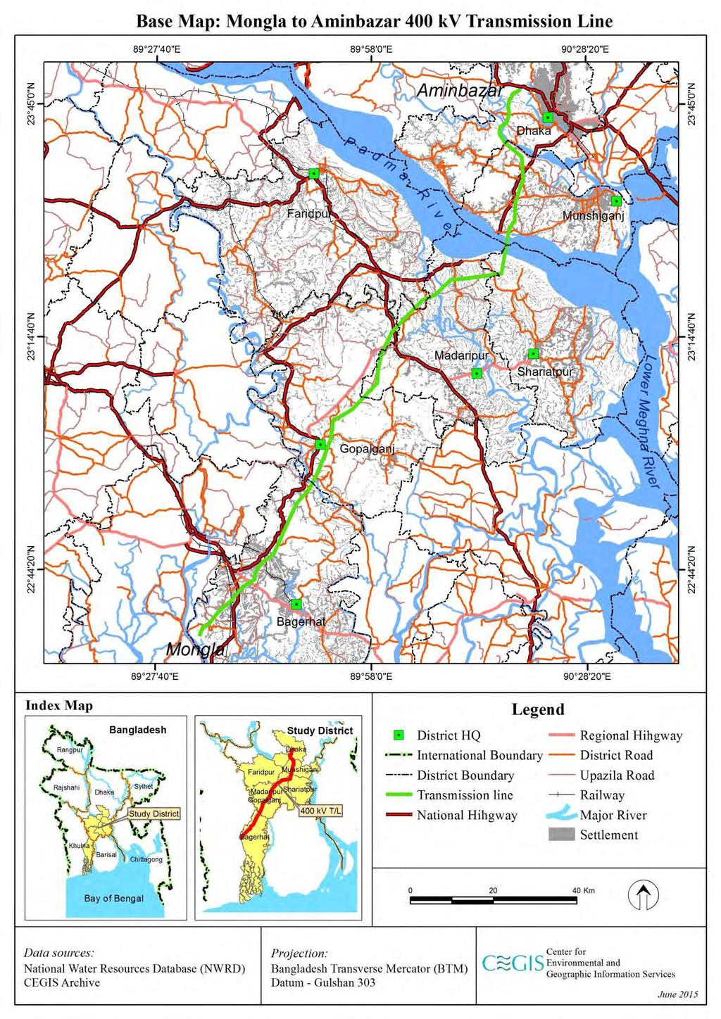
32 7

33 Map Base Map of the Proposed Project 1.7 Methodology 22. IEE is an initial examination for estimating the potential environmental impacts of a proposed project. IEE is undertaken within a relatively short period of time based on preliminary information available at hand or on information which can be readily obtained through an environmental reconnaissance. The IEE study undertaken for this project specifically follows the steps described below. Figure 1-1 -Steps of Initial Environmental Examination (IEE) i. Analysis of Project Components 23. All aspects of the TL and GS construction works and activities have been examined rigorously prior to developing a checklist to conduct reconnaissance surveys. ii. Preparation of Checklist 24. A comprehensive checklist of potential environmental parameters has been prepared based on various guidelines of different agencies such as DoE, World Bank, ADB and JICA. The checklist has been used to conduct a reconnaissance survey. iii. Initial Screening and Baseline Survey 8
34 25. The list of parameters identified in the previous step has been shortened to focus on significant effects. In addition data has been collected from all possible secondary sources. Environmental and socio-economic data from different sources (e.g. Bangladesh Bureau of Statistic (BBS), DoE, Bangladesh Meteorological Department (BMD), Bangladesh Water Development Board (BWDB), Agro- climatic survey of Bangladesh and other IEE reports) have been collected to prepare the baseline environmental and socio- economic profile of the study area. CEGIS s multi-disciplinary team of experts made reconnaissance visits to observe the condition of the project site and its surroundings and to identify alternate sites for investigation. 26. Final checklists have been prepared and the environmental baseline survey has been conducted with the relevant checklist in hand to identify and delineate the significant effects of the Project. iv. Scaling of Impacts 27. A short description of existing physical, social and environmental condition of project sites has been prepared and the impacts of project intervention on the physical, environmental and social components have been graded in order to identify important components. v. Identification of Enhancement and Mitigating Measures 28. Enhancement and mitigating measures for beneficial and adverse effects respectively have been defined. vi. Preparation of IEE Report 29. Finally an IEE report has been prepared following standard chapter outlines. 1.8 Structure of the Report 30. The IEE report is structured as follows: Chapter 1: Introduction and Methodology: The introduction chapter presents a brief overview of the assignment along with its background, objectives, scope of work, methodology etc. Chapter 2: Policy and Legislation: Outlines the policy and legislation on environmental issues. Chapter 3: Description of the Project: Describes the proposed project interventions including alternative options suggested for the project, background, project category, need for the project, location, size and magnitude of operation. Chapter 4: Environmental and Social Baseline Condition: Chapter Four presents a description of the environmental baseline condition (socio-economic, physical and biological) of the study area. Chapter 5: Anticipated Environmental Impacts and Mitigation Measures: This chapter deals with the environmental impacts of the proposed project and possible mitigation measures. 9
35 Chapter 6: Alternative Sites and Transmission Routes: This chapter analyses different alternatives of the transmission line routes. Chapter 7: Public Consultations: This chapter describes the public consultation process undertaken to inform the people of the study area and to obtain their opinion and meaningful feed-back. Chapter 8 Grievance Redress Mechanism: This chapter set out the time frame and mechanisms for resolving complaints about environmental performance. Chapter 9 Environmental Management Plan: The chapter mainly defines the detailed Environmental Management Plan for the project along with the monitoring program. Chapter 10 Conclusions: This chapter presents the findings, conclusion, and recommendations of the project. 10
36 Chapter 2 Policy and Legislations 2.1 Overview 31. Implementation of the Project by the PGCB requires strict compliance with laws, rules and regulations pertinent to the environment. In Bangladesh, the DoE is responsible for ensuring the application of environmental laws and issuance of necessary clearances. 32. The procedures and requirements for EIA for projects in the power sector are dictated by the Environment Conservation Act of 1995, which introduced a requirement for any proposed "industrial unit or project" to obtain prior approval from the DoE. 33. The Environment Conservation Act has classified projects to be assessed (by the DoE) in four categories (green, amber A, amber B, and red). Power sector development projects are allocated to the red category, which triggers an automatic requirement for an IEE followed by a full EIA. Subject to a satisfactory review of the environmental assessment, the DoE issues an authorization for the project to proceed. The authorization consists of two parts: a "site clearance", which gives approval to the site proposed for the project and "environmental clearance", which approves the content of the project. 34. The PGCB, as the project proponent, is responsible for carrying out an EIA study of the proposed project. Therefore, it has the responsibility to administer the environment assessment process with consultants, review the findings of consultants, and submit documents to the DoE for their review. 35. A key requirement of the EIA for projects classified in the amber and red categories is an Environment Management Plan (EMP). The function of the EMP is to enable the project proponent (PGCB) to show the DoE how it will deliver the environmental performance assessed in the EIA (for which DoE approval is sought). The EMP must describe in detail the organization and management responsibilities, give details of how mitigation measures identified in the EIA will be implemented and explain how monitoring will be carried out. 36. Possession of a "clearance'' from the DoE does not relieve the developer of a project from the requirement to comply with other environmental regulations. In particular, the Bangladesh National Environment Quality Standards (EQS) for industrial effluent have been set and compliance is mandatory. In addition, there are statutory instruments applicable to power development projects, which are not primarily environmental in nature, but, which influence environmental impacts. Compliance with such statutory instruments is mandatory Procedure for Obtaining Site/Environmental Clearance Requirement for IEE Reports 37. All industries and projects in the red category must conduct IEEs, which help in understanding the potential extent of environmental changes as a result of the project. 11
37 The IEE finds ways to mitigate negative impacts by considering available information, past experience or standard operating practices. The steps for conducting IEEs are as follows: Collection of baseline information in respect of a project and the environmental setting of the project and its site. Setting of boundaries of an IEE by identifying the significant issues. Impact assessment suggesting mitigation measures, development of an EMP, and discussion of alternative sites for the project or other project modifications. In the event the IEE of the project or industry reveals that further investigation is required to be carried out, the sponsors will have to conduct a detailed EIA Procedure 38. After completion of the IEE Report the project proponent should apply to the DoE in the prescribed format for site/ environmental clearance. The application for environmental clearance for the project classified in the red category should be accompanied by the following documents: Feasibility Study Report of the industry (project) IEE report A NOC (No Objection Certificate) from the local authorities concerned Pollution minimization plan including emergency plan for mitigation of adverse environmental impacts Outline of relocation plans (where applicable) Other information as deemed necessary 39. The Environment Conservation Rules give the Director General of the DoE the discretion to issue environmental clearance directly without issuing any site clearance to any industry or project if he (the Director General) finds an appropriate reason for doing so. 40. As the proposed Project, augmentation of the Aminbazar GS and TL facilities falls under the red category, all necessary requirements mentioned above have been adopted by PGCB for the Project. Figure 2-1 shows the activities involved in obtaining environmental clearance from the DoE. 12

 in requiring EMPs for proposed, as well as current, projects. 2.")
38 Figure 2-1 -DoE Environmental Clearance Procedures APPLICATION TO DoE RED The application should enclose: - Feasibility Study Report (for proposed industry/ project); - Initial Environmental Examination Report and Environmental Impact Assessment Report; - Environmental Management Plan; Obtaining Site Clearance Applying for Environmental Clearance Obtaining EnvironmentalClearance Clearance subject to annual renewal NOC Note: = No Objection Certificate, usually obtained from local government. 1. these requirements vary from those of the DoE (1997) in requiring EMPs for proposed, as well as current, projects. 2. Procedure of obtaining Environmental Clearance: for Green Category Projects the gestation period for granting Environmental Clearance has been fixed at within 15 days; for Orange A, Orange B and Red Category Projects at first Location Clearance and thereafter Environmental Clearance will be granted. The gestation period for Location Clearance is within 30days for Orange A, and within 60days for Orange B and Red Category Projects. Source: Adapted from the Environmental Guidelines for Industry (DoE, 1997) 13
39 2.2 Organization Related with Enforcement of Environmental Standards 41. Roles and responsibilities of various Ministries and Departments involved in the enforcement of environmental requirements are described below: Ministry of Environment and Forest (MoEF) 42. The Ministry of Environment and Forest (MoEF) is the key government institution in Bangladesh for all matters relating to national environmental policy and regulatory issues. Realizing the ever-increasing importance of environmental issues, the MoEF was created by replacing the Ministry of Agriculture and Forest in 1989 and is at present a permanent member of the Executive Committee of the National Economic Council. This group is the major decision-making body for economic policy issues and is also responsible for approving all public investment projects. The MoEF oversees the activities of the following technical/implementing agencies: Department of Environment (DoE) Forest Department (FD) Forest Industries Development Corporation (FIDC) Department of Environment (DoE) 43. In order to expand the scope of environmental management and to strengthen implementation powers, the Government adopted the Environmental Pollution Control Ordinance in The ordinance provided for the establishment of an Environmental Pollution Control Board, which was assigned with the responsibility of formulating policies and proposing measures for their implementation. In 1982, the Board was renamed as the Department of Environmental Pollution Control (DEPC). Six divisional offices were established in Dhaka, Chittagong, Khulna, Barisal, Sylhet and Rajshahi. 44. A special presidential order renamed the DEPC as the Department of Environment (DoE) and placed it under the newly formed MoEF in The DoE is a department of the MoEF and is headed by a Director General (DG). The DG has complete control over the DoE. The power of the DG, as given under the Act, is outlined as follows: The DG has the power to close down activities considered harmful to human life or the environment. The operator has the right to appeal and procedures are in place for this. However, if the incident is considered an emergency, there is no opportunity for appeal. The DG has the power to declare an area affected by pollution as an ecologically critical area. The DoE governs the type of work or process, which can take place in such an area. Before undertaking any new development project, the project proponent must take an environmental clearance from the DoE. Clearance has been obtained dated 11/02/2016. Failure to comply with any part of the Environment Conservation Act (ECA) 1995 may result in punishment by a maximum of 5 years imprisonment or a maximum fine of Tk. 100,000, or both. 14
40 2.2.3 Forest Department 46. This Department under the MOEF is responsible for the protection and management of all reserve forests in the country. Department personnel extend down to the union level in areas where there are reserve forests. The Department has recently started some agro forestry programs and its officers are also responsible for the protection of wildlife in the forests Related Other Organizations 47. There are several other organizations, which have certain social and environmental functions. These organizations include: Ministry of Land: Land Reform and Land Acquisition Directorate Ministry of Water Resources: BWDB Ministry of Fisheries and Livestock: Directorate of Fisheries 2.3 National Policies and Legislation Relevant to Environment 48. National strategies, policies, acts and rules related with the environment include the following: Environment Pollution Control Ordinance, Environmental Quality Standards for Bangladesh, 1991 National Conservation Strategy (NCS) 1992 Environment Policy (1992) National Environment Management Action Plan (NEMAP) 1995 Environment Conservation Act (1995) Environment Conservation Rules (1997) 2.4 Other Relevant Acts Related to Environment The Bangladesh Wildlife Preservation Order (1973; amended to Act in 1974) 49. The Bangladesh Wildlife (Preservation) Order 1973 and the amendment to the Act in 1974 provides for the preservation, conservation and management of wildlife in Bangladesh. The earlier legislations on wildlife preservation, namely, the Elephant Preservation Act, 1879, the Wild Bird and Animals Protection Act, 1912, and the Rhinoceros Preservation Act, 1932 have been repealed and their provisions have been suitably incorporated in this law The National Forest Policy (1994) 50. The National Forest Policy of 1994 is the amended and revised version of the National Forest Policy of 1977 in the light of the National Forestry Master Plan. The main target of the policy is to conserve existing forest areas and bring about 20% of the country's land area under the forestation program and increase the reserve forest land by 10% by the year 2015 through coordinated efforts of Government Organisations (GOs), Non- Government Organisations (NGOs) and active participation of the people. 15
41 2.5 Policy Related with Energy Development The Electricity Act, 1910 and Electricity Rules This Act amended the laws relating to the supply and use of electrical energy. Under the Act, any person can obtain a license to supply energy and lay down or place electric supply lines for the conveyance and transmission of energy. The licensee can open and break up the soil and pavement of any street, railway or tramway and can lay down any line or do other work near other utility services (gas, telecommunication, water, sewer, etc.), provided prior permission is taken from the respective authority, as stated in Section of the Act. 52. According to Section 19 (1) of this Act, the licensee shall give full compensation for any damage, detriment or inconvenience caused by him or by anyone employed by him. 53. Sub- section (1) of Section 51 of the Electricity Rules, 1937 advises that licensee should take precautions in laying down electric supply lines near or where any metallic substance or line crosses in order to avoid electrocution The Telegraph Act (1885) 54. Under Sections 10-19, Part III (Power to place Telegraph Lines and posts), the government can build towers on public land without giving any land compensation The Power Policy, As with the Petroleum Policy, this is presently an integral part of the National Energy Policy It has different policy statements on a whole range of issues including demand forecast, long- term planning and project implementation, investment and lending terms, fuels and technologies, power supply to the west zone, isolated and remote load centers, tariff, captive and stand by generation, system loss reduction, load management and conservation, reliability of supply, system stability, load dispatching, institutional issues, private sector participation, human resource development, regional/international cooperation, technology transfer and research program, environment policy and legal issues. 56. As the proposed project is a Power Transmission Project, all necessary requirements mentioned above will be adopted for the project The Energy Policy (1996 updated 2004) 57. The first National Energy Policy (NEP) of Bangladesh was formulated in 1996 by the Ministry of Power, Energy and Mineral resources to ensure proper exploration, production, distribution and the rational use of energy resources to meet the growing energy demands of different zones, consuming sectors and consumers groups on a sustainable basis. With rapid change of the global as well as the domestic situation, the policy was updated in The updated policy includes additional objectives namely to ensure environmentally sound sustainable energy development programs causing minimum damage to the environment, to encourage public and private sector participation in the development and management of the energy sector and to bring the 16
42 entire country under electrification. The policy highlights the importance of protecting the environment by requiring an EIA for any new energy development project, or introduction of economically viable and environment friendly technology The Industrial Policy (1999) 58. The National Industrial Policy, 1999 aims to ensure a high rate of investment by public and private sectors, a strong productive sector, direct foreign investment, development of labor intensive industries, introduction of new appropriate technology, women's participation, development of small and cottage industries, entrepreneurship development, high growth of export, infrastructure development and environmentally sound industrial development. WTO guidelines have been proposed to be followed in the Industrial Policy. 2.6 Compliance with International Requirements 59. Bangladesh has acceded to, ratified or signed a number of major international treaties, conventions and protocols related to environment protection and conservation of natural resources Rio Declaration 60. The 1992 the United Nations Conference on Environment and Development (UNCED) adopted the global action Program for sustainable development called 'Rio Declaration' and 'Agenda 21'. Principle 4 of The Rio Declaration, 1992, to which Bangladesh is a signatory along with a total of 178 countries, states, "In order to achieve sustainable development, environmental protection should constitute an integral part of the development process and cannot be considered in isolation from it" Convention on Biological Diversity, (1992) 61. The Convention on Biological Diversity, Rio de Janeiro, 1992 was adopted on 5 th June 1992 and entered into force on 29 th December Bangladesh ratified the Convention on 20 th March, This is the overarching framework for bio-diversity and the signatories are required to develop a National Bio-diversity Strategy and Action Plan that incorporates the articles of the Convention into national law and statutes. 62. Obligation has been placed on state parties to provide for environmental impact assessments of projects that are likely to have significant adverse effects on biological diversity Wetlands of International Importance as Waterfowl Habitat, (1971) 63. Convention of Wetlands of International Importance as Waterfowl Habitat (1971) is also known as the Ramsar Convention. It was adopted on 2nd February 1971 and entered into force on 21st December Bangladesh ratified the Convention on 20th April This provides a framework for national action and international cooperation for the conservation and wise use of wetlands and their resource. There are 127 Parties with 1085 wetland sites designated as 'Wetlands of International Importance'. 17
43 64. This is an intergovernmental treaty, which provides the framework for international cooperation for the conservation of wetland habitats. Obligations for Contracting Parties include the designation of wetlands to the "List of Wetlands of International Importance', the provision of wetland considerations within their national land use planning, and the creation of natural reserves. 65. Bangladesh has two Ramsar sites-parts of the Sundarbans Reserved Forest (Southwest of Bangladesh) and Tanguar Haor (Northeast of Bangladesh). The proposed project will not have any effect on these two Ramsar sites United Nations Framework Convention on Climate Change (UNFCCC) 66. The Kyoto Protocol to the UNFCCC was adopted in 1997 and requires developed countries and economies in transition listed in Annex B of the Protocol, to reduce their GHG emissions by an average of 5.2% below 1990 levels. Article 12 of the Kyoto Protocol provides for the Clean Development Mechanism (CDM). According to CDM, projects are eligible to earn CERs (Certified Emission Reductions) if they lead to "real, measurable, and long-term" GHG reductions, which are additional to any that would occur in the absence of the CDM project UN Convention on the Law of the Sea, Montego Bay, (1982) 67. This Convention was adopted on 10th December, 1982 at Montego Bay, Jamaica and Bangladesh has ratified this Convention Others (Conventions and Agreements) 68. The following conventions and agreements include provisions which may be relevant for environmental management, nature protection, and biodiversity conservation: Convention relative to the Preservation of Fauna and Flora in their Natural State 1933; International Convention for the Protection of Birds, Paris, 1950; International Plant Protection Convention, Rome, 1951; The Convention concerning the Protection of the World Cultural and Natural Heritage, Paris, 1972 has been ratified by 175 states. This defines and conserves the world's heritage by drawing up a list of natural and cultural sites whose outstanding values should be preserved for all humanity. Of the 730 total sites, there are currently 144 natural, 23 mixed and 563 cultural sites that have been inscribed on the World Heritage List (distributed in 125 State parties). These are the 'Jewels in the Crown' of conservation; Convention on International Trade in Endangered Species of Wild Fauna and Flora, Washington, 1973 (Popularly known as CITES): This provides a framework for addressing over harvesting and exploitation patterns which threaten plant and animal species. Under CITES governments agree to prohibit or regulate trade in species which are threatened by unsustainable use patterns; and Convention on the Conservation of Migratory Species of Wild Animals, Bonn, 1979 (Amended 1988): This provides a framework for agreements between countries important to the migration of species that are threatened. 18
44 2.7 Compliance with ADB Safeguard Policy Statement, ADB's environmental and social safeguards form the cornerstone of its support to inclusive economic growth and environmental sustainability in Asia and the Pacific. In July 2009, ADB's Board of Directors approved the new Safeguard Policy Statement (SPS) governing the environmental and social safeguards of ADB's operations. The objectives of the SPS are to avoid, or when avoidance is not possible, to minimize and mitigate adverse project impacts on the environment and affected people, and to help borrowers strengthen their safeguard systems and develop the capacity to manage environmental and social risks. 70. ADB environmental safeguards emphasis development and implementation of a comprehensive environmental management plan (EMP). Key elements of EMPs are mitigation measures, monitoring programs, cost estimates, budgets, and institutional arrangements for implementation. In addition, the environmental assessment process emphasizes public consultation, information disclosure, and consideration of alternatives. 71. The key safeguard areas which must be addressed are (i) environmental, (ii) involuntary resettlement, and (iii) indigenous peoples. 72. ADB adopts a set of specific safeguard requirements that borrowers/clients are required to meet in addressing environmental and social impacts and risks. 73. ADB will not finance projects that do not comply with its safeguard policy statement, nor will it finance projects that do not comply with the host country s social and environmental laws and regulations. 74. The safeguard policy statement applies to all ADB- financed and/or ADB- administered sovereign and non- sovereign projects, and their components regardless of the source of financing. 2.8 ADB s Environment Safeguard Requirements- Policy Principles 75. Environmental assessment incorporate the following policy principles: Projects are screened and assigned to one of the following categories as soon as possible. Table 2.1-ADB s Environment Safeguard Requirement Category A B Assessment Required A proposed project is classified as category A if it is likely to have significant adverse environmental impacts that are irreversible, diverse, or unprecedented. These impacts may affect an area larger than the sites or facilities subject to physical works. An environmental impact assessment is required. A proposed project is classified as category B if its potential adverse environmental impacts are less adverse than those of category A projects. These impacts are site-specific, few if any of them are irreversible, and in most cases mitigation measures can be designed more readily than for category A projects. An initial environmental 19
45 C F1 examination is required. A proposed project is classified as category C if it is likely to have minimal or no adverse environmental impacts. No environmental assessment is required although environmental implications need to be reviewed. A proposed project is classified as category F1 if it involves investment of ADB funds to or through a Financial Intermediary. For projects deemed by ADB as highly complex and sensitive, use an independent advisory panel during project preparation and implementation. Conduct an environmental assessment for each proposed project. Assess potential trans-boundary and global impacts, including climate change. Examine alternatives to the project s location, design, technology, and components. Avoid/minimize, mitigate, and/or offset adverse impacts. Prepare an EMP Carry out meaningful consultation with affected people and facilitate their informed participation. Disclose a draft environmental assessment (including the EMP) in a timely manner, before project appraisal, in an accessible place and in a form and language(s) understandable to affected people and other stakeholders. Disclose the final environmental assessment, and its updates if any, to affected people and other stakeholders. Implement the EMP and monitor its effectiveness. Document and disclose monitoring results. Do not implement project activities in areas of critical habitat, unless (i) there are no measurable adverse impacts on the critical habitat that could impair its ability to function, (ii) there is no reduction in the population of any recognized endangered or critically endangered species, and (iii) any lesser impacts are mitigated. If a project is located within a legally protected area, implement additional programs to promote and enhance the conservation aims of the protected area. Apply pollution prevention and control technologies and practices consistent with international good practices such as the World Bank Group s Environmental, Health and Safety Guidelines. Provide workers with safe and healthy working conditions and prevent accidents, injuries, and disease. Conserve physical cultural resources and avoid destroying or damaging them by using field- based surveys. 2.9 Compliance with PGCB Health Environment and Safety (HES) Requirements 76. The PGCB has its own policy and requirements for compliance relating to environment, health and safety issues for its operations. The company is committed to managing its operations in a safe, efficient and environmentally responsible manner. The PGCB's 20
46 HES manuals, guidelines, procedures and plans are important tools of their commitment. HES manuals include: Environmental Impact Assessment Module, Guideline on Integrated Impact Assessment, Health Impact Assessment Module, and Social Impact Assessment Module. 77. In addition, requirement for impact assessment is affirmed in the PGCB's Statement of General Business Principles. The PGCB is committed to: Pursuing the goal of no harm to people, Protecting the environment, and Managing HES as any other critical business activity. 78. The mandatory company Operations Management System (OMS), Environmental Care Element/ Standards, issued in March 1997, makes reference to Environmental Assessment indicating that "Environmental Impact Assessment (including a consideration of social impacts) shall be conducted prior to all new activities and facility developments, or significant modifications of existing ones Building Construction (Amendment) Act, 1990 & Rules The initial Building Construction (amendment) Act dates back to The earlier Government Buildings Act, 1899, provided for the exemption from the operation of municipal building laws of certain building and lands, which were the property or in the occupation, of the GoB and situated within the limits of a municipality. The provision of Municipal Building Laws to regulate the creation, recreation, construction, alteration or maintenance of buildings within the limits of any municipality was superseded by the 1990 Act. The need to regulate the haphazard construction of buildings was addressed by the East Bengal Legislative Assembly and the "Building Construction Act, 1952" was promulgated on 21 March 1953 as the East Bengal Act II of The Act was framed to allow streamlining of planned development and implement beautification programs of the government. 80. An important modification to the 1953 Act was added through an Ordinance titled, "the Building Construction (Amendment) Ordinance, 1986 (Ordi. No. LXXII of 1986)". Later in 1987, the ordinance was adopted for enactment as "The Building Construction (Amendment) Act, 1987 (Act No. 12 of 1987)". The preamble of Building Construction (Amendment) Act states that the objectives of the amendment reveals that "although the trial court has the power to order removal of unauthorized construction after passing the order of conviction under section 12, this power has been found to be insufficient, as a criminal case cannot normally be finally disposed of quickly, besides even after disposal of the criminal case by the trial court, the prosecution is lingered by way of appeals". In order to take steps to prevent unauthorized construction or to remove such construction, an authorized officer is empowered through this amendment so that he/she can take necessary action in this respect without intervention of the court. 21
47 81. The Act was subjected to another amendment in 1990 allowing power to issue limited sanction to cut down or raze any hill within the area to which this Act applies. 82. To support the implementation of the provisions laid down in the Building Construction Act, 1952, the GoB made the Building Construction Rules, This was superseded by the Imarat Nirman Bidhimalas, Later in 1996 GoB framed the Imarat Nirman Bidhimala, 1996 (Building Construction Rules, 1996). The rules are more comprehensive and more relevant to present day circumstances and issues of building construction and other related development activities Rules and Policies in Related Fields 83. In addition to the policies, rules and regulations related to the environment and energy, the following rules and regulations, listed in Table 2.2 are to be checked for compliance for maintaining a sustainable environment. Table 2.2-Environmental Laws, Regulations and Standards of Bangladesh Year Title Objectives 1885 The Telegraph Act (Act XIII of 1885) Under the law sections 10-19, GoB built transmission lines through the country The Electricity Act (Act IX of 1910) Under the law section 51, GoB built transmission lines through the country East Bengal Protection and Protection and conservation of fish in Conservation of Fish Act Bangladesh The Protection and Conservation of Fish Rules Prevention of harming fisheries resource and fisheries habitat in coastal and inland waters Town Improvement Act Improvement and development of Dhaka City Antiquities Act Protection and preservation of archaeological and historical artifacts 1960, Port rules, shipping operation Control of discharges in ports; waterway rules Factories Act Industrial workers' health and working conditions Pesticide Ordinance Pesticide use, production, selection and importation Antiquities (Amendment) Ordinance Protection and prohibition of export of archaeological artifacts Municipal Ordinance Municipal activities in health, sanitation, water supply, drainage, etc. in the city Factory Rules Disposal of wastes and effluents Agricultural Pesticides (Amendment) Act Selection, use and handling of pesticides in the agricultural sector Municipal Act Drainage, sewerage, water supply and sanitation Acquisition and Requisition of Immovable Property ordinance The Acquisition of Immovable Property Rules, 1982 (No. S. R. O U82) The GoB adopted these rules in exercise of the powers conferred upon by section 46 of The Acquisition and Requisition of Immovable Property Ordinance, 1982 (Ordinance No. II of 1982). 22
48 Year Title Objectives 1983 Agricultural Pesticides (Amendment) Revised Agricultural Pesticides Ordinance. Ordinance 1985 The Pesticide Rules Pesticide selling, use and safety measures Bangladesh standard specification Formulation and revision of national standards. for drinking water The Penal Code This contains several articles related with environmental protection and pollution management Building Construction (Amendment) Act and Building Construction Rules The Rules are more comprehensive for taking care of the present day circumstances and issues of building. 23
49 Chapter 3 Description of the Project 3.1 Background of the Project 84. The Project consists of the three components i.e. Construction of the new 400 kv double circuit transmission line from Aminbazar to Mongla 174 km, A new 400 kv Grid substation with 3 x 520 MVA transformers at Aminbazar adjoining the existing sub station 85. PGCB is the power transmission company in Bangladesh, and it is responsible for operation, maintenance and development of the power transmission system at 132 kv and above. PGCB has experience in development, operation and maintenance of 400 kv TLs with two operational 400 kv lines, namely (i) Meghnaghat-Aminbazar (Phase I) and (ii) Bheramara-Baharampur, which provides the grid interconnection between Bangladesh and India. One more 400 kv line, Bibiyana-Kaliakoir TL, is currently under construction. Similarly, PGCB has experience with 400 kv air insulated switchgear (AIS) associated GSs connected with 400 kv TLs that are in operation and under construction. 86. Bangladesh Bridge Authority (BBA) will lay the foundations to place the footings and platforms for the seven transmission towers planned alongside the proposed bridge required to cross the Padma River. These seven tower footings will be downstream of the bridge. BBA will build the foundations up to the stub level, and thereafter, the towers will be built and conductors strung, under the Project. The seven towers for the TL are regarded as an associated facility to the Project. 87. At present, there are two interconnections between the Western Zone and the Eastern Zone of the PGCB transmission network, via the Northern Zone. However, there is no interconnection between the Western Zone and Dhaka at present. The proposed Aminbazar-Maowa-Mongla TL will be the first interconnection between the Western Zone and Dhaka, improving the reliability of electricity supply to Dhaka. 88. The Power Grid Corporation of India Limited has carried out the feasibility study for the Aminbazar-Maowa-Mongla TL for PGCB in which technical, financial and economic viability has been assessed. However, this feasibility study did not include an environmental and social impact assessment of the TL, which has been subsequently conducted. 3.2 Project Category 89. Under the criteria of DoE, power TL and GS projects fall under the red category. As per the EIA Guidelines of the DoE, it is mandatory to carry out an IEE for red category projects prior to conducting a more detailed EIA. PGCB consultants CEGIS, prepared an IEE report to meet DoE requirements; this was approved. Following the IEE report and the preparation of TOR site clearance has been given to PGCB, CEGIS prepared an EIA 24

50 to fulfill the DoE requirement. The full Environmental (Environmental Clearance for the Project was provided by DoE on 11/02/2016 Ref Memo No: DoE/Clearance/5503/2015/70) 90. For PGCB s development partner ADB, the project has been classified as categorized B according to SPS 2009 and will require an IEE. This report is prepared to meet the requirement for ADB environmental assessment. 3.3 Project Location 91. The project is located in the central and south-central regions of Bangladesh and the TL is in Dhaka, Faridpur, Gopalganj, Shariatpur, Munshiganj, Madaripur, and Bagerhat Districts of Bangladesh with augmentation of the GS at Aminbazar in Dhaka District. Map 3.1 -Transmission Line Route and Road Access 3.4 Physical Features of the Transmission Line and Towers 92. The main physical features of the proposed 400 kv TL are given in Table 3.1. The TL will be double circuit and conductor materials will be made of aluminum alloy. The standard TL towers are steel and of two types tension/angle towers and suspension towers. Tension towers (Photo 3.1) are designed to take the tension of the load cable and are also used at turning points in the TL route alignment when the line deviates more than 5 degrees. Suspension towers (Photo 3.2) carry only the weight of the conductors and are 25
51 used when the route alignment is straight. Much larger special towers are constructed at location in longer spans for the Padma River crossing. Porcelain disc type insulators will be used (see Photo 3.3) on the suspension towers. Table 3.1 -Physical Features of Mongla to Aminbazar Transmission Line and Towers Sl. No. Physical Features Attribute 1 Voltage rating 400 kv 2 Type of transmission line Double circuit 3 Width of TL RoW 50 meters for Resettlement Purposes 4 No of transmission towers 581 including 7 on platforms in the Padma River 5 Transmission towers heights Standard towers: 50-60m. Towers at river crossing:133m 6 Transmission line clearances 10 m for standard lines and 25 metres above the 50 year flood level in the case of the Padma River 7 Type of line support Steel 400 kv pole 8 Conductor material Aluminum alloy 9 Line insulator Disc type, porcelain 10 Type of connection GS at Aminbazar 11 Duration of project implementation Approximately 36 months Source: PD office, PGCB 93. There will be 581 transmission towers along the TL including seven which will be built on raised platforms which are constructed in the Padma River. The standard tension and suspension towers are m high. There will be adequate clearances below the TL with a minimum of 10 m clearance between the highest flood level and the lowest sag levels of the TL over land; clearance margins can be increased if there is any chance of interference with anything beneath. The transmission towers in the Padma River have spans of 828 m between towers and will be over 130 m high. These 7 towers will be erected on platforms of 20 m x 20 m which sit on columns raised nearly 20 m out of the river and pile supported. The lowest sag point of the TL will have a safety clearance of at least 10 m above vessels passing underneath at the highest flood level. Towers in the Padma River will be built with stronger steel and the pile work and platforms are designed to withstand ship impacts. The TL route is downstream of the new Padma Road Bridge by 2.2 km on the left bank and 2.3 km on the right bank ( Map 3.2). Anchor towers will be built on either side of the river to accommodate the long spans and will join the 400 kv line on the land at either side of the river. Due to the structure heights, aircraft warning spheres will be installed on the earth wire. Piling and platform structures for the river crossing are being supplied and constructed by the Padma Bridge Multipurpose Project and work in the river began in October PGCB is responsible only for the erection of the towers on these platforms in the river. PGCB will be responsible for the towers on land and on the river banks including the river bank anchor towers. 26


52 Map 3.2 -Padma River Bridge and Transmission Line Crossing Photo Tension Tower 27


 available")
53 Photo Suspension Towers Photo 3.3 -Disc Insulators for Transmission Line 3.5 The Aminbazar Grid Substation 97. The site for the GS extension at Aminbazar is 10 acres (4 ha) available within the existing GS (see Map 3.3). 28

54 Map Site of Aminbazar 400kV Grid Substation 98. The proposed Air-insulated Switchgear (AIS) at Aminbazar has specifications as indicated in Table 3.2. Table 3.2 -Physical Features of AIS GS, Aminbazar Features Type Specification Proposed Land ownership Scheme Substation type Voltage Switchgear type Insulation medium power circuit breaker Transformer Protection system description 10 acres (4 ha) land filled & acquired already Main busbar scheme AIS 400 kv Air-insulated SF6 GAS Oil insulated Auto fighting water spray system Source: PD s office, PGCB 29

55 Photo Existing 230 kv/132 kv Grid Substation at Aminbazar 3.6 Components of Construction Works 99. The phasing of construction works for the TL and the two GSs are indicated in Table 3.4 below. Table 3.4 -Phasing of Construction Activities Components Transmission Line Grid Substation Preconstruction Activities During Construction Route survey Contractor and manpower recruitment Tender Establishment of construction documents camps for workers preparation Clearing of RoW Establishment of temporary access tracks Transport of materials and equipment to tower sites Civil work (foundation work, RCC, etc.) Tower erection including work from barges in the Padma River Conductor stringing Accidental hazard Topographical survey Establishment of material storage areas and work sites Establishment of construction camps for workers Establishment of temporary access tracks Transport of materials and equipment to site 30 Post Construction/ Operation period Clearing of RoW Operation and maintenance (O&M) Accidental hazard Operation and maintenance (O&M) Accidental hazard
56 Activities During Construction Components Preconstruction Post Construction/ Operation period Clearing site Civil work (land filling, foundation, RCC work, Equipment installation Testing and commissioning Accidental hazard 3.7 Construction Equipment 100. For this project all equipment to be installed will be procured from outside Bangladesh. Construction materials such as bricks, sand, cement, reinforcing rods, etc. will be sourced locally. 3.8 Civil Construction Works Back-filling of Grid Substation Sites 101. Land allocated for augmenting Aminbazar GS, 4 ha available within Aminbazar GSS premises, is at the same level as the rest of the GS, and hence no back filling is required Earth Work in Foundations 102. Construction of GS requires earthwork excavation for the foundation to the required depth. For tower foundations, there will be a minimum of four concrete pads for each tower and the tower footprint has a coverage of between 9 m 2 and 11 m 2. Top soil is removed for the general area of the footprint. The area will be cleared and individual foundation pads are constructed. The first layer of topsoil which is excavated should be kept in designated areas. On completion of foundation work, back-filling of the excavated area will be done with local soil and sand. In the case of TL towers the soil can be replaced immediately beneath the tower structure Foundation Treatment 103. Geo-technical investigations will be conducted to assist in designing foundations of structures. It will help to identify whether foundation treatment will be required or not. The type of treatment like pre-cast RCC piling or in situ concrete piling, removal of peat or loose soil will be suggested as per results of geo-technical investigation. Pilling depth will vary with soil type and in the case of transmission towers depending on the location and type of tower required. The foundation work for the transmission towers in the Padma River has been undertaken by the Padma Bridge Authority as part of the bridge project and this is underway. 31
57 3.8.4 Back Filling with Local Sand 104. Back filling of the excavated area of the foundation and floor of the GS buildings will be undertaken with local sand RCC Work 105. RCC work will be required for roof, column, beam, and floors of GS buildings and foundation for transformers, circuit breaker, steel structure and the TL towers Brick Work up to Plinth Level and Superstructure 106. Brickwork for constructing buildings will be with first class bricks and coarse sand and cement up to roof level and shall have adequate plinth protection Plastering and Finishing 107. Concealed electric wiring of good quality and proper size is to be installed and bulbs and switchboards are to be provided. Plastering of walls inside and outside as well as the roof of the building will be undertaken with proper curing for at least three weeks. Distemper or plastic painting will be applied to the walls and roof of the building Wood Works/Aluminum, Windows and Glass Fittings 108. Wood/aluminum works are to be undertaken on door shutters and windows of buildings along with glass fittings Sanitary Works 109. Sanitary works such as laying of sewerages (either PVC or RCC), installation, fittings and fixing of toilet accessories will be included in building work Water Supply System 110. Water supply system will be connected for worker use with extension of the existing supply for the existing Aminabazar GS. If necessary additional tube wells will be set up Boundary Fencing with Concrete Pillar and Barbed Wire 111. The project GS areas will be protected from any unauthorized entrance of the public by fencing around the boundary with a six feet high wall with barbed wire fitted and concrete pillars three (3) meters apart. 3.9 Electrical Works and Towers 112. For GSs, installation of equipment will include transformers, circuit breakers, isolators, lightning arresters, panel boards, batteries and battery chargers etc All equipment will be installed at GSs (outdoor and indoor) as per design specification and standard. For this project, all material will be procured from foreign countries. Use of 32

58 domestic materials will be minimal; local materials like bricks, sand, cement, and reinforcing rods, will be used for the installation works Transformers are heavy equipment. Transportation of all such equipment and construction material for augmentation work of the Aminbazar GS should, however, be possible through the existing Aminbazar GS and its existing access road Erection of Tower 115. Transmission towers will be constructed to take the load of the tower, cables and accessories, and are designed to meet specifications for wind load and earthquake load. Towers in paddy fields will have proper clearance at maximum level of sag (lowest point on line). At homesteads, if any, the sag can be adjusted higher to clear the canopy The towers will be erected by a team who are subcontracted for this activity. The parts are brought to site in small sections and are stored temporarily at site. Tower legs will have concrete piled foundations, and the towers will be assembled piece by piece as indicated in Photo Special arrangements will be put in place for erection of the towers in the Padma River with the use of cranes and barges which will be anchored against the 7 platforms constructed in the river (3 in the deep navigable section) by the BBA. Bridge piles and piles for platforms for towers are being constructed by the BBA, who will build them as part of infrastructure associated with the Padma Multipurpose Bridge. Test piling began in Oct 2105 and lasted for all that month km (right bank) and 2 km (left bank) of revetment training works associated with the bridge project will protect and reinforce the river embankments upstream of the point where the TL cross the Padma River. BBA will secure the tower leg parts on the platforms and PGCB will then take over the construction using a small crane and a gin pull to assemble the towers piece by piece. Photo Tower Erection Work 33
59 3.9.2 Drawing of Transmission Line 118. The TL will be drawn into position using stringing equipment: winches, pullers, tensioners and puller-tensioners especially designed for stringing operations. The lines can be drawn from both sides and helicopters may also be used. The configuration of the lines will ensure that the lowest design sag points are adhered to Testing and Commissioning of Equipment 119. Following installation of all equipment the GS will be tested as per specification and standards and will be commissioned accordingly Work Schedule 120. The completion of works is proposed to take place in 36 months as indicated below in Figure 3-1. Figure 3-1 Project Implementation Schedule 34
60 Chapter 4 Environmental and Social Baseline Condition 4.1 Project Boundary 121. The Project is to be constructed in Central and South-Central regions in Dhaka and Khulna Divisions covering 7 districts (Dhaka, Faridpur, Gopalganj, Shariatpur, Munshiganj, Madaripur, and Bagerhat). Within these 7 districts there are 17 upazila and 53 union local administrative units. For the CEGIS base line IEE of the Project, the focus of the study was limited to the area where physical impacts of the activity will be directly felt i.e. a 20m corridor along the TL RoW, plus a 40m buffer along both sides of the power TL (i.e. 40m m= 100m). The corridor consists of 20 m immediately below the TL and an additional 40 m either side which is likely to be affected by project construction activity. This 100 m RoW corridor is referred to as the study area in the IEE and EIA reports prepared by CIGES for project approval The Project has wider geographic and social impacts during project pre-construction, construction and post-construction and benefits will extend to the regional as well as national scale. 4.2 Physical Environment Climate General 123. The Project falls under the influence of the monsoon climate prevailing in the general area which has three main seasons: Pre-monsoon, summer- March to May Monsoon, rainy season June to October, and Winter season November to February The summer is hot and dry interrupted by some heavy rainfall. The monsoon is characterized by hot and humid conditions when a substantial part of the annual rainfall occurs. The winter is predominantly cool and dry Information on meteorological parameters i.e. rainfall, temperature, wind speed, and sunshine hours have been collected from the BMD station at Dhaka which is close to Aminbazar and has lengthy historic data, and for Madirapur on the TL route. The following sections provide information on the meteorology in the area of the Project Rainfall 126. Rainfall data ( ) at Dhaka BMD station show significant rainfall from May to October with the driest period from November to March. The highest and lowest monthly average rainfall have been experienced in the months of July (381mm) and January (68mm) respectively. Maximum rainfall ever recorded in the data was 856 mm during one event in the month of June. 35

61 Figure 4-1-Monthly Cumulative Rainfall at Dhaka BMD Station 127. Rainfall data at the Madaripur BMD station shows a similar seasonal pattern to Dhaka. The wettest period stretches from May to September and the driest period is from November to March. September has a maximum of 854 mm while during the months of November to February rainfall maximums are small with only 41 mm in December. The highest and lowest average cumulative monthly rainfall for the 41 year period of records are mm (July) and 5.46 mm (December) respectively. Figure 4-2-Monthly Cumulative Rainfall at Madaripur BMD Station 36
62 4.2.3 Temperature 128. Temperature data for the last sixty-five years ( ) from the BMD station in Dhaka, see below, show monthly maximum temperatures range from 31 O C in December to 42.2 O C in April. Minimum temperatures range from 5.6 O C (January) to 21.5 O C (July). Figure Monthly Maximum and Minimum Temperatures at Dhaka BMD Station Humidity 129. Relative humidity indicates the presence of moisture in air. Data ( ) for monthly maximum, average and minimum relative humidity for Dhaka station indicate that the monthly average value of relative humidity is at its highest at 85% in July. Humidity remains high during the monsoon period (June to October) at 80% or more, but declines steadily to reach a low of 62% in March, before increasing again with the onset of the monsoon Data from Madirapur station for relative humidity ( ) show percentages that vary from 68.84% to 86.47% from March (the end of the dry season) to July respectively. From June to October (monsoon period) relative humidity is always high (around 80%) due to higher rainfall intensity. Post monsoon relative humidity is lower falling by more than 10% with less rainfall Sunshine 131. Monthly sunshine hour data from the BMD station in Dhaka shows average sunshine hours per day have ranged across the year from a low of 4.49 hours (July) to a high of 8.23 hours (March). The monsoon period has comparatively fewer sunshine hours due to increased cloud cover. 37


63 Figure 4-4 -Monthly Average Sunshine Hours Per Day at Dhaka BMD Station 132. Monthly sunshine hour data from the BMD station in Madaripur are plotted in Figure 4-5, and it displays less sunshine hours than Dhaka. Average sunshine hours per day have ranged from 3.62 in July to 7.21 in April. The monsoon period, particularly between June and September has comparatively fewer sunshine hours due to the increased cloud cover and rainy days. Figure Monthly Average Sunshine Hours Per Day at Madaripur BMD Station Wind Speed 133. Data for Dhaka shows monthly average wind speeds gradually decrease from a high of 2.07 m/s in April to a low of 0.46 m/s in November. 38


64 Figure Variation of Monthly Average Wind Speed at Dhaka BMD Station 134. Figure 4-7 shows the variation of the monthly average wind speed measured at Madaripur BMD station, on the TL route. Data shows a gradual decrease in wind speed from April to November. Highest and lowest average wind speeds have been recorded in April and November and are 97.8 km/day and 22.5 km/day respectively. Figure Monthly Variation of Average Wind Speed at Madaripur BMD Station Seismicity 135. Bangladesh has been classified into three seismic zones as indicated in the Map 4.1. The TL between Khulna and Aminbazar is situated mainly in the safest zone (Zone 3) with a seismic coefficient of 0.04 g. A small portion of the TL line and the Aminbazar GS is in the moderate zone (Zone 2) with a seismic coefficient of 0.05 g. Foundations for the 39
65 GSs and TL towers will be designed accordingly with capacity to resist prevailing earthquake forces. Map Earthquake Zones of Bangladesh and the Proposed Project 136. Noise Level Table
66 Table 4.1 -Standard Values for Noise (dba) Standard Value (dba) Category Zones Day Night A Quiet places (hospitals, education institutions, etc.) B Areas which are used mainly for residential purpose C Areas which are used for residential and commercial purposes D Commercial area E Industry area Source: Environmental Conservation Rules, 1997, DoE 137. IFC/ World Bank EHS Guideline 2007 and ADB SPS 2009 stipulate 55 dba day time and 45 dba night time of residential/institutional/educational receptors and 70 (day and night) for industrial and commercial receptors As the TL will cross some rural residential areas, the standard value for ambient noise should not exceed 50 dba i.e. Category B during day time (6 a.m. - 9 p.m.). Noise levels in urban and rural areas are near or above these standards. Table 4.2 displays noise levels of some locations inside the study area. Table Noise Level of Several Locations Sl. No. Date and Time Location GPS Coordinate Noise Level (dba) Tekerhat Bridge, Rajoir, N :15 PM Madaripur E Borni, Rampal, Bagerhat N :30 AM E Line crossing, Sirajdikhan N :17 PM E Bangchora, Pachor, Shibchar, N :30 PM Madaripur E Jazira, Shariatpur Ferry ghat N :15 PM E :30 PM Dhaleshwari Bridge N E Source: IEE Study, CEGIS 4.3 Air Quality 139. The standard values for ambient air quality according to the Bangladesh Environmental Conservation Rules for the area for different categories are shown in Table 4.3. Table 4.3 -Standards of Ambient Air Quality Area Categories Concentration Micrograms per Meter Cube SPM SO 2 CO 2 NOx A Industry B Commercial C Residential and rural area
67 D Sensitive Source: Environmental Conservation Rules, DoE Suspended particulate matter (SPM) may be present during project construction with dust from earth works at the GSs and tower foundation sites. However, earthworks will take place on a small scale only. Other source of particulate matter emissions will be from transportation of materials by vehicle. 4.4 Water Resources Water Systems and Water Quality 141. There are several rivers that govern the hydrology of the study area. There are also many lakes/ water bodies in the area. Map 4.2 shows the river systems and the TL route. The Padma is by far and away the largest river in Bangladesh; it is the distributary of the Ganges River and is joined by the Jamuna River (the name for the Brahamaputra in Bangladesh). The Padma-Ganges is the central part of a deltaic river system with hundreds of rivers and streams--some 2,100 km in length, flowing into the Padma and eventually discharging into the Bay of Bengal. The Padma River is known for heavy bank erosion, shifting channels, and sandbars that continually emerge in its course. The River is a busy waterway Table 4.4 shows the surface water quality standards of Bangladesh. Best Practice Based Classification Table 4.4 Standards for Inland Surface Water Quality ph BOD mg/l Parameters DO mg/l Total Coliform number/100 a. Source of drinking water for supply or less 6 or above 50 or less only after disinfecting: b. Water usable for recreational activity : or less 5 of more 200 or less c. Source of drinking water for supply or less 6 of more 5000 or less after conventional treatment : d. Water usable by fisheries: or less 5 of more -- e. Water usable by various process and or less 5 of more 5000 or less cooling industries : f. Water usable for irrigation: or less 5 of more 1000 or less BOD Biochemical Oxygen Demand DO Dissolved Oxygen Source: Schedule 3 (A) Environmental Conservation Rules 1997, Bangladesh Map River Systems of Bangladesh 42

68 4.4.2 Water Sample Collection 143. CEGIS took water samples in June 2015 from rivers and khals in the Study area and various parameters including total dissolved solids (TDS), ph, electrical conductivity 43


 has been found at Dhaleshwari River. Maximum (4.6 mg/l) DO has been recorded at Padma River.")

69 (EC), dissolved oxygen (DO) were measured. In maximum cases, ph value is around 7.5 indicating the surface water of the Project is almost neutral. TDS values measured are over 100 ppm on average. Samples have been collected in sunny days so that temperatures are moderate (around 30 0 C). EC has been found to be between ms/cm. Quantity of DO has fluctuated from place to place due to pollution of surface water. Lowest DO (3.5 mg/l) has been found at Dhaleshwari River. Maximum (4.6 mg/l) DO has been recorded at Padma River. The DO levels comply with Environmental Conservation Rules (ECR) 1997 for inland waters. The high level of salinity at the first location at Rampal is assumed to be because of sea water influence in tidal river. Collective data for several parameters are given Table 4.5. Photo Water Quality Test at Modhumoti River Photo Sample Collection from Padma River (Jazira, Shariatpur Ferryghat) 44

70 Table Results of Testing of Water Samples TDS = Total Dissolved Solids, DO = Dissolved Oxygen and EC = Electrical Conductivity Source: IEE Study, CEGIS and Laboratory Test (DPHE) 45
71 4.4.3 Water Levels and Flooding 144. Most of the land along the TL is low lying and many sections of the route are under water during the wet season for eight months. To analyze the flooding propensity, information from two surface water level measuring stations at Maowa and Mongla are presented. Figure gives monthly water level data from BMD station in Maowa (on the TL route) and Mongla. There is a significant annual variation in water levels recorded with a maximum average level in the month of August (5.68 m above mean sea level) and a minimum average level in February (1.46 m above mean sea level). Figure Flood Hydrograph Showing Monthly Average Water Level Source: BWDB 145. Table 4.6 shows the flood frequency analysis of the same two locations (BWDB stations) for different return periods. Table 4.6- Water Level at Different Return Periods Return Period Years Water Level (m+ mean sea level) Maowa Water Level (m+ mean sea level) Mongla Source: IEE Study, BWDB, CEGIS 46
72 146. Although it is low lying and there is a lot of standing water during the monsoon season, most of the TL route is not in flood prone areas and there is no risk from flood hazard. The proposed GS sites will be raised well above the surrounding land (10 m in the case of Aminbazar) in order to minimize the flood risk. The foundations of the GS sites and TL towers are designed taking the potential flood risks into consideration Erosion 147. The banks of Padma River have suffered from erosion problems annually, mostly in the monsoon and post monsoon periods. This is in the process of being stabilized with extensive embankment work undertaken on both sides of the river in conjunction with the construction of the new Padma Multipurpose Bridge crossing Storms 148. Seasonal storms, popularly known as nor westers (Kalbaishakhi) occur in the study area. Tornadoes can be associated with severe nor westers. The frequency of nor westers is greatest in April and they most often occur in late afternoons. 4.5 Land Resource Agro-ecological zones 149. There are 30 agro-ecological zones (AEZ) and 88 sub zones have also been identified in Bangladesh. An AEZ is a zone or region with a unique combination of physiographic (land forms and parent materials), soil properties, soil salinity, depth and duration of seasonal flooding, agro-climatology (FAO/UNDP, 1988, BARC, 2012) The study area falls in seven of the AEZs and these zones are shown in Map 4.3 in conjunction with TL alignment. Detailed information on AEZs of the study area is presented in Table 4.7 indicating the soil characteristics to be found in the study area including soil texture and quality. 47

73 Map Agro-ecological Zones in the Study Area 48
74 Table 4.7 -AEZs and Soil Characteristics Along the Transmission Line Route No. AEZs and No. Soil Characteristics Organic ph Soil Soil Quality Matter (%) Texture 1 Young Brahmaputra and Jamuna Flood Plain(AEZ-8) Low- Medium Silt loam to silty clay loam Soils are deficient in N, P and S but the status of K and Zn is low to medium. 2 Active Ganges Floodplain (AEZ- 10) 3 High Ganges River Floodplain (AEZ- 11) 4 Low Ganges River Floodplain (AEZ- 12) 5 Ganges Tidal Floodplain (AEZ- 13) 6 Arial Beels (AEZ- 15) 7 Old Meghna Estuarine Floodplain(AEZ-19) Low- Medium Low- Medium Low- Medium Low- Medium Sandy, silty and clayey alluvium Silt loam and silty clay loam Silt loam and silty clay loam General fertility level is medium with high CEC and deficient in N, P, B and Zn contents. General fertility level is low including N, P, S and B although CEC is medium. The K- bearing minerals are medium to high, but the Zn status is low to medium. General fertility level is low to medium, CEC and K status is medium to optimum and the Zn status is low to medium Silty clay Very high CEC and K status. There are limitations of high exchangeable Na and low Ca/Mg ratio. The Zn status is low to medium and the B and S status is medium to optimum. Medium Clayey Organic matter content generally exceeds 2% in the top and subsoil. Available moisture holding capacity is inherently low, having high CEC, and general fertility level is medium to high, N status is very low to low and B status is very low. Top soil ph ranges from slightly acidic to neutral. Low- Medium Silty clay to clay General fertility level is medium. Status of K is low to optimum. The level of P is very low to low, S is low to medium and B status ranges from low to optimum. B- Boron, Ca- Calcium, CEC-Cation Exchange Capacity, K- Potasium, Mg- Magnesium, N- Nitrogen, Na- Sodium, P- Phosphorus, S- Sulphur and Zn- Zinc Sources: BARC, 2012 and information based on PGCB, Land use 151. Land use is dominated by human activity. Of the 1,713 ha of land which compromises the total gross study area, the great majority is farmed land. The net cultivated area (NCA) is calculated at 1,410 ha (82%); the rest is settlement land, rivers and water bodies as per CEGIS assessment in June 2015 based on SOLARIS-SRDI This is presented in Table 4.8 and the following Map 4.4. Much of the land categorized as NCA is 49
75 rice land which is in fact under water for more than half the year and cultivated in the dry season only. Table 4.8 -Existing Land Use in the Study Area Land use Area(ha) % of Gross Area NCA 1, Settlement River 78 5 Water bodies 18 1 Total gross area 1, Sources: CEGIS Assessment in June 2015 based on SOLARIS-SRDI

76 Map Land Use Map of Bangladesh 51
77 4.5.3 Land type 152. All the land in the study area is low lying and land type classifications are based on the depth of inundation of agricultural land during the monsoon season due to normal flooding. Four classes of land types are identified by the Soil Resources Development Institute (SRDI). High land is regarded as land above the normal inundation level during the monsoon and only 12% of land in the NCA falls into this category. The highest coverage (59%) of land falls in the medium low land type (F 2 ) followed by 24% in the medium high land type (F 1 ). Detailed information on land types is presented in Table 4.9 and the following map. Table 4.9 -Land Type of the Study Area Land Type Area (ha) % of NCA F 0 (high land) above inundation level F 1 (medium high land) above normal inundation level F 2 (medium low land) normally inundated cm depth F 3 (low land) normally inundated cm 59 4 Total 1, Sources: CEGIS Assessment in June 2015 based on SOLARIS-SRDI

78 Map Land Types in Bangladesh 53
79 4.6 Agriculture Resources Cropping Pattern and Cropping Intensity of the Study Area 153. Much of the land within the TL RoW is intensively used for agricultural crop production. Cropping follows the pattern indicated in Table 4.10 with between one and three crops being grown annually. The most prominent cropping pattern within the buffer area of RoW is Fallow, followed by Lt. Aman rice followed by Fallow; this pattern is found in 20% of the NCA. The next most popular pattern is Jute, Fallow and Onion and then Fallow, Lt. Aman rice and High Yield Variety (HYV) Boro rice. Each of the latter two cropping combinations are used in15% of the NCA Single, double and triple cropped areas are about 24%, 65% and 11% of the NCA respectively and cropping intensity of the study area is about 187%. Table Detailed Existing Major Cropping Pattern in the Study Area Kharif-I Kharif-II Rabi Study Area (March-June) (July-October) (November- February) Area(ha) % of NCA Jute Fallow Wheat 71 5 Jute Fallow Onion Jute Fallow Garlic Jute Fallow Potato 71 5 Jute Fallow Potato-HYV Boro Fallow Lt. Aman Fallow Maize Lt. Aman Fallow 71 5 Fallow Lt. Aman Mustard-HYV Boro 42 3 Fallow HYV T. Aman HYV Boro Fallow Lt. Aman HYV Boro Fallow Fallow HYV Boro 56 4 Total 1, Cropping intensity (%) 187 Source: CEGIS Assessment based on field information, June,
80 Photo 4.3 A Jute Field Within the Study Area Photo 4.4 A Maize Field Within the Study Area 55
81 4.6.2 Cropped Area 155. Total cropped area of the NCA is 2,641 ha of which rice and non-rice cropped areas amount to 1,312 ha and 1,329 ha respectively. Detailed information on cropped area is presented in Table Project impacted land is mainly agricultural and it is anticipated that approximately 23 ha will be directly impacted due to construction of the 581 towers along the RoW. Of this, about 5 ha are double cropped cultivated with rice (Lt. Aman and HYV Boro varieties); about 15 ha is single cropped cultivated with HYV Boro rice and the remaining 3 ha is single cropped and cultivated with Lt. Aman Crop Yield and Production 156. Crop yield rates were obtained during CEGIS field study in consultation with officials of Department of Agricultural Extension (DAE) and farmers. For the last three consecutive years average yields (ton/ha.) have been calculated. It has been observed that there had been no crop damage for the last three consecutive years. Therefore, crop production was calculated on the basis of crop yield against crop area. The detailed existing crop production of the study area is presented in Table 4.11 Table Crop Area, Yield and Annual Crop Production in the Study Area Crop name Study Area Crop Area (ha) Yield (ton/ha) Production (tons) % Contribution HYV Boro * 2, HYV T. Aman * Lt. Aman * 1, Total Rice 1, , Maize Wheat Potato , Mustard Jute , Onion , Garlic , Total non-rice 1, , Total 2, ,075 - Source: CEGIS Assessment based on field information and DAE, June, 2015 * indicates cleaned rice 157. The total crop production in the study area has been estimated at 20,075 tons of which rice production is 3,542 tons and non-rice is 16,534 tons making 18% and 82% respectively Agricultural Input 158. About 50% of cultural practices for crop production are undertaken manually and agricultural labor is an essential input for crop production. 56
82 159. Major fertilizers used in this area are urea, triple super phosphate (TSP) and muriatic of potash (MP). Most of the farmers apply fertilizer in an unbalanced way. The use of pesticides depends on the degree of pest infestation. Most common insects reported by farmers to CEGIS during the IEE field survey in June 2015 have been stem borer, green leaf hopper, grass hopper, rice bug, jute hairy caterpillar, cut worm and aphids. Local farmers reported that they are using different types of pesticides such as Fighter, Virtako, Darsban, Rifit, Sumithion and Mukti, etc. to prevent pest infestation in rice, wheat, potato, jute, mustard, onion, garlic and maize cultivation. Liquid, granular and powder pesticides are being used for pest control Irrigation coverage of the study area comprises 40% of the NCA during the dry season. Irrigation is mainly for growing HYV Boro rice. Ground water is extracted with the use of Shallow Tube Wells (STWs). Most of the khals are silted up and dried up from February to April and irrigation is not provided in these areas. HYV, T. Aman and Lt. Aman rice are cultivated under rain-fed condition. Supplementary irrigation is also provided to fields of maize, wheat, potato and mustard cultivation. Detailed information is presented in Table Table Detailed Information on Irrigated Area by Crop Crop name Irrigation (Ground water) Area (ha) % of NCA Charge (Tk/ha) HYV Boro rice ,500 Potato ,500 Maize ,500 Wheat ,500 Mustard ,000 Source: CEGIS Assessment based on IEE field survey, June, Local farmers reported that lack of irrigation water in the rabi season is the main constraint on production. Siltation of rivers and different internal drainage channels is another problem. Khals (as already mentioned) dry up in the dry season (February to April). Farmers also said that irrigation with diesel operated devices is costly rather than using electrical devices, and irrigation is being hampered because of this. Salinity also restricts crop production to some extent in Khulna, Bagerhat and Gopalganj Districts. 4.7 Fisheries Resource Introduction 162. The fisheries resource along the proposed 400 kv TL are both brackish and fresh water in nature. The TL crosses various water features including rivers, khals (drainage canals), Bagda gher (shrimp ponds) and other ponds which function as fish habitats both seasonally and perennially. These habitats make substantial contribution to the local as well as national fishery resources. They also function as migratory routes, breeding and nursery grounds. Many people make their livelihood either catching, culturing or trading fish. The TL can have some adverse impact on these fisheries. There will, however, be 57
83 only a small loss of habitat due to construction of towers and loss of land at the tower pads The Padma River is famous for the species known as Hilsa. Besides Hilsa other fishes such as carp, kata, mrigel, chapila, baila, boal are found. Hilsa and carp are considered important species from economic and livelihood perspectives Habitat Description 164. Fisheries habitat in the study area can be categorized broadly as capture (mainly in the brackish zones) and culture fishery resources (mainly in fresh water zones). The capture fishery constitutes rivers, khals and floodplain whereas the culture fishery comprises of Bagda gher and Golda gher (shrimp/prawn ponds) and aquaculture ponds. Some rivers (e.g. the Pashur River Moiur River) and khals (Barani and Ramdia Khal) are tidal and function as fish breeding, nursery and grazing ground for brackish water fish species Fresh water rivers such as the Padma, Madhumati, Berar Nadi and Kumor Nadi which are perennial serve as the spawning migration route of some fish (Ilish, Rui, Catla, Mrigel, Pangus, etc.) and fish breeding grounds. The char area about 10 km upstream of the new Padma bridge acts as a nursery ground for fish such as carp, kata, mrigel, kalibaush, etc., and the Padma is the migratory route for Hilsa (Ilish) particularly during the months of March to May. The Bagda ghers situated adjoining tidal rivers or Khal support shrimp cultivation along with certain white fish all year. The Golda ghers which are seasonal practice prawn cultivation along with other white fish during the wet season. Other ponds are brought under aquaculture practice by applying different culture technologies like mono-, poly- and mix culture with major and exotic carp species The estimated fish habitat of the study area is about 1,025 hectare (ha). Capture fishery contribute 86% of this and the rest is culture fisheries. The distribution of habitat is floodplain 78%, followed by Bagda gher 11%, river and Khal 8%, Golda gher 3%, and fishpond 0.5%. Fish habitat of the study area is shown in Table Table Fish Habitat Status in the Study Area No. Fisheries Category Habitat Types Area (Ha) 1 Capture River and Khal 80 2 Floodplain 800 Sub-total Culture Bagda Gher Golda Gher 30 5 Fish Pond 5 Sub-total 155 Grand total 1,025 Source: CEGIS estimation using satellite imagery, Fish Production Assessment 167. The production of capture fishery resources in the study area is derived from river/khal and floodplain. The production of culture fishery resources is derived mainly from Bagda 58
84 gher, seasonal Golda gher in wet season and cultured pond (semi-intensive and extensive ponds) The annual fish production of the study area has been estimated to be 165 tons in The yearly production from different fish habitats and the relative contribution of different fish categories and habitat is presented in Table Table Estimated Annual Fish Production in the Study Area No. Fisheries Category Habitat Types Production (Ton) 1 Capture River and 7 Khal 2 Floodplain 100 Sub-total Culture Bagda Gher 41 4 Golda Gher 8 5 Fish Pond 9 Sub-total 58 Grand total 165 Source: Production estimation based on Fisheries Resource Survey System, Fish Biodiversity 169. Fish diversity has declined over the years and this had been evident during consultations held with local fishermen and elderly people at Bagerhat, Rampal, Mollahat, Tongi, and Maowa (CEGIS 2015). It has been reported that in the past, fish species like Ilish, Pungus, Boal, Rui, Catla, Chital, Ayre, Rita, etc were amply available in the Madhumati, Berar, and Kumor rivers. Major factors believed to be responsible for this reduction have been reported as: (i) reduction of riverine habitat (ii) fishing with use of destructive gear; (iii) increased fishing pressure, (iv) obstruction of fish migration routes, (v) expansion of application of fertilizer and pesticide in agriculture land; (vi) increasing industrialization near the river bank and release of industrial waste into river, etc. Indicative fish species in different habitats of the study area are presented below with local and scientific names Riverine major brackish water fish species are: Hilsh or Ilish (Tenualosa ilisha), Boal (Wallago attu), Poa (Johnius amblycephalus), Koral (Lates calcarifer), Dogri (Apocryptes bato), Datni (Pomadasys argenteus), Guilla (Mystus gulio), Tengra (Mystus bleekeri), Gura chigri (Leander styliferus), Bailla (Acentrogobius caninus), Bagda (Peneaus monodon), Chewa (Taenioides anguillaris), Pathari (Abudefduf bengalensis), Tairu (Platax teira), Chitri (Scatophagus argus), Khalla (Liza parsia), Kata (Plicofollis layardi) and Olua (Coilia neglecta) Riverine major fresh water fish species include: Rui (Labeo rohita), Catla (Catla catla), Mrigel (Cirrhinus cirrhosus), Boal (Wallago attu), Ayre (Spetara aor), Foli (Notopterus notopterus), Pabda (Ompok pabda), Baim (Mastacembelus armatus), Bata (Labeo bata), Silong (Silonia silondia), Tengra (Mystus bleekeri), Gulsha (Mystus cavasius), Puti (Puntius spp), Bele (Glossogobius giuris), Shol (Channa striatus), Taki (Channa punctatus), Golda (Macrobrachium rosenbergii) and Kajuli (Ailia coila). 59
85 172. Shrimp farm fish species include: Bagda (Peneaus monodon), Golda (Macrobrachium rosenbergii), Koral (Lates calcarifer), Khalla (Rhinomugil corsula), Guilla (Mystus gulio), Tilapia (Tilapia nilotica), Tailla/Surma (Polydactylus sextarius) and Bailla (Acentrogobius caninus) Culture fish species in ponds include: Rui (Labeo rohita), Katol (Catla catla), Mrigel (Cirrhinus cirrhosus), Silver carp (Hypophthalmichthyes molitrix), Grass carp (Ctenopharyngodon idela), Mirror carp (Cyprinus carpio), Thai pangus (Pangasius sutchi), Tilapia (Tilapia mossambicus), Nilotica (Tilapia nilotica) and Sharpunti (Puntius sarana) Threatened Fish Species 174. The Padma River EIA (2010) indicated that the general degradation of the Padma River and its tributaries for more than last 30 years has resulted in extinction of several species of fishes. According to Flood Action Plan (FAP)-17, (Fisheries Studies and Pilot Project, 1993), 260 species of fishes were found in the north western region of the country of which 143 belonged to small fishes. More than 41 species of small fishes are on the verge of vulnerability now. These include: Shankha, Fansha, and four varieties of Puti, Khayera, Pabda, Panikoi, Bancha, Milon, Yellow Tengra, Bele, Ganges Pangas fish, Bheda fish and Bou fish. IUCN has made a list of vulnerable species of different areas of Bangladesh. Based on the red list, 29 species of conservation significance in the Padma is indicated in Table Table 4.15 Significant Fish Species and Their Status Scientific name Local name Common name CE EN VU Labio calbasu Calbaus Black Rui Chitala chitala Citol Humped Feather back Cirrhinus reba Bhangna Reba carp Labio bata Bata Bata Labio L.nandina Nandil Nandi Labeo L. pangusia Ghora mass Pangusia Labio P.sarana Sarputi Olive Barb P.ticto Tit puti Ticto Barb Raiamas bola Bol Indian trout Rasbora rasbora Leuzza darkina Gangetic Scissortail Rasbora Botia dario Beti Necktie Loach Mystus aor Aor Long whishkeper Cat fish M. seenghala Guizza Ayer Gaint river catfish Mystus cavasius Golsa Tengra Gangatic Mystus Ompok bimaculatus Kani pabda Indian Buutter Catfish Ompok pabda Modhu pabda Pabdah Catfish 60
86 Ompok pabo Pabda Pabo Catfish Clupisoma garua Gharua Garua Bacha Eutropiichthys vacha Bacha Batchwa bacha Bagarius yarrellii Bagghair Gangetic Goonch Chaca chaca Cheka Indian Chaka Monopterus cuchia Kuicha Cuchia Chanda nama Nama Chanda Elonget Glass-perchlet Pseudambassis ranga Ranga chanda Indian Glassy fish Nandas nandas Meni Mud perch Ctenops nobilis Neftani Indian paradise fish Channa marulis Gajar Giant snakehead Macrognathus aral Tara baim One strip spinyeel Mastacembalus armatus Sal baim Tire-track Spinyeel Note: CE= Critical Endangered, EN= Endangered, VU =Vulnerable 4.8 Ecology Biological Environment 175. The study area falls in various terrestrial and aquatic ecosystems consisting of mainly floodplain lands, peat lands and river terrain. With a variation of land forms, the area once supported a natural abundance of wildlife and vegetation. The study area land use today is much changed with homesteads and intensive agriculture, but many rivers, beels, ponds, ditches and floodplain still support various species of flora and fauna Bio-ecological Zoning 176. IUCN-The World Conservation Union has identified 25 bio-ecological zones (2002) based on physiography, climate, soil type, flooding depth and biodiversity. The proposed TL route and GS locations fall within five of these defined bio-ecological zones, i.e.; Gopalganj/ Khulna Peat Lands, the Brahmaputra-Jamuna Floodplain, the Saline Tidal Floodplain, the Ganges Floodplain and Major Rivers. Table 4.16 gives the area of land in the study area which is located in each of the five bio-ecological zones. Map 4.6 shows the bio-ecological zones of Bangladesh in relation to the TL route. Table Area and Location of Biological Zones within the Study Area Bio-ecological Zone Area (ha) Percentage (%) District Ganges Floodplain Saline Tidal Floodplain Gopalganj/Khulna Peat Lands Bagerhat, Gopalganj, 61
87 Brahmaputra-Jamuna Floodplain Major Rivers Madaripur, Shariatpur, Munshiganj, Faridpur and Dhaka Total Ecosystem Diversity 177. The RoW of the proposed TL study area predominantly comprises paddy land/floodplains followed by homesteads, terraces, canals in the order of significance. Overall ecosystems in the study area can be divided into following categories: 178. Crop fields: This land is usually used for paddy cultivation once/twice/thrice in a year and inundated during the monsoon period. In these areas there is least diversity of floral communities but numerous indigenous fishes and birds find feeding habitat Settlements/Homesteads: This ecosystem comprises economic tall plants e.g. jute, maize with undergrowth of wild flora. Homesteads are constructed at comparatively high elevation, and settlement/homestead land exhibits mainly terrestrial ecology. Homestead platforms and higher agricultural land is also used for commercial plantations of fruit and timber yielding trees for furniture making and also to meet domestic fuel wood needs Canals and Rivers: Canals and rivers are the main sources of water in the general study area for all ecological components both terrestrial and aquatic. The main rivers (Padma, Dhaleshwari, Madaripur beel route, Madhumati and Pashur) are perennial sources of water. Numerous canals also exist along the proposed TL route and these support scattered hydrophytes in areas which retain water for at least a part of the year Ponds and Ditches: This is largely closed water wetland areas and is controlled to meet human needs for domestic use and for irrigation purposes. Water levels fluctuate widely with the seasons, and various smaller water dependent animals are supported in this environment Roadside vegetation: Fast growing flora are planted to protect embankments and roads from soil degradation and erosion. The lower land is occupied by marginal vegetation, while along the road side the species indicated in are planted are found in Table Mangrove ecosystem: This system is found at the Khulna South West end of the TL route. Tidal flows in the area support many mangroves species. The ecotone or transition zone between two ecosystems (tidal and freshwater) had abundant mangrove vegetation. This is now much changed with river levees and canal banks inhibiting the tidal flow to develop fish culture. There are, however, some mangrove forest patches with the species Gala (Exocearia agallocha) and Kewra (Sonneratia apetalla) in Raznager Union, Rampal Upazila, in Bagerhat District where the TL route begins in the SW. Other mangrove species in the areaare Kankra (Bruguiera gymnorrhiza), Hargoza (Acanthus illicifolius), Ora (Sonneratia caseolaris) and Golpata (Nipa fruticans). Kankra and Tiger Fern grow vigorously in disturbed mangrove habitats. 62
88 4.8.4 Biodiversity 184. Terrestrial Flora: The study area contains a diversity of species in different ecosystems described above. In and around homesteads species are planted according to their potential for human use and consumption for timber, fuel and fruit purposes. Trees that are to be found are Gagon Sirish (Albizia richardiana), Rendi Sirish (Albizia saman), Sada Koroi (Albizia procera), Mahagoni (Swietenia mahogoni) and Eucalyptus (Eucalyptus sp). For fruit demand (coconuts, banana, dates, mango etc) the following species are grown Narikel (Cocos nucifera), Taal (Borassus flabellifer), Kola (Musa sp.), Khejur (Phoenix sylvestris), and Aam (Mangifera indica) mainly around homesteads. Bamboo is also grown widely in the study area. Commercially planted crops are to be found in homesteads, along village roads and directly in crop land, and the following three species predominate - Akashmoni (Acacia moniliformis), Mahagoni (Swietenia mahagoni) and Taal (Borassus flabellifer) or the Asian sugar palm. See following table. 63
89 Map Bio-ecological Zones of Bangladesh and the Transmission Line Route 64

")
 Anacardiaceae Fruit and Timber H 20-25 Akashmoni (Acacia sp.")
 medicine 20-25 Sirish (Albizia lebbeck)")
90 Photo Major Ecosystems of the Study Area Photo Mangrove Vegetation Inside River and Canal Areas Tiger or golden leather fern (Acrostichum aureum) Kankra or Black Mangrove (Bruguiera gymnorrhiza) Table Plants Species Growing Along the Proposed Transmission Line Route Average Height (Meter) Tree Species Family Usage Density Narikel (Cocos nucifera) Palmae Fruit and fuel H wood Aam (Mangifera indica) Anacardiaceae Fruit and Timber H Akashmoni (Acacia sp.) Mimosaceae Timber and fuel H wood Bansh (Bamboosa sp) Poaceae Thatching H Mahagoni (Swietenia Meliaceae Timber and H mahagoni) medicine Sirish (Albizia lebbeck) Leguminosae Timber and fuel H wood Chambul (Albizia richardiana) Leguminosae Timber H 65
91 Average Height (Meter) Tree Species Family Usage Density Eucalyptus (Eucalyptus sp) Leguminosae Timber and fuel M wood Rendi Sirish (Albizia saman) Leguminosae Timber and fuel M wood Taal (Borassus flabellifer) Palmae Fruit and Timber M 9-12 Khajur (Phoenix dactylifera) Arecaceae Fruit and Fuel M wood 5-7 Katbel (Limonia acidissima) Rutaceae Fruit and Timber L 8-10 Supari (Areca catechu) Palmae Timber and fuel M wood Tatul (Tamarindus indica) Leguminosae Fruit L Silkoroi (Albizia procera) Leguminosae Timber and fuel M wood Sisso (Dalbergia sissoo) Fabaceae Timber and fuel M wood 7-10 Gewa (Exocearia agallocha) Euphorbiaceae Timber and fuel L wood 6-8 Kawra (Sonneratia apetala) Sonneratiaceae Fruit and fuel L wood 5-8 Kanthal(Artocarpus Moraceae Fruit and Timber M heterophyllus) Kadom(Anthocephalus Rubiaceae Timber and fuel L chinensis) wood 3-5 Desi Gaeb (Diospyros peregrina) Ebenaceae Fruit L Source: CEGIS Field survey, 2015; Note: H = High M = Medium L = Low 185. While cultivated species predominate in the landscape, there are a variety of other species of flora, both native and non-native, such as Digiteria spp (wild grass), Eclipta alba (false daisy a herb), Echinochola colonum (jungle rice), Hemarthrira sp (herbaceous grass), Polygonum spp (knotweed family), Rumex aciculate (buckwheat family), Alternanthera sessilis (aquatic plant), Dentella repense (creeping plant), Cynodon dactylon (couch grass) and Cyperus spp (sedges) to be found on agricultural lands Aquatic Flora: There is a great floral diversity of aquatic plant life in the river, canals and seasonal floodplains and ditches inside agricultural lands. Among the free floating species, Kochuripana (Eicchornia crassipes) is mostly found inside rivers and canals. Shapla (Nymphaea spp.) and Chandmala (Nymphoides sp) grown in floodplains during monsoon and comprise the common rooted floating plant. Also the species Hydrilla versillata, and Hygrorhiza aristata are present along with the rarer Enhydra fluctuans and Ludwigia species. None of these species will be affected by the low level of activity generated during construction which will also take place out of the wet season. Fauna 66

 are absent in the study area. Common mongoose (Herpestes edwardsi) and some bats are found.")
92 187. Terrestrial Fauna: Mammals species are few in number or have disappeared completely from the study area owing to the lack of natural forest cover and the change in habitat with loss of native plant species. Even small mammals which are present in forest patch habitats and open grasslands elsewhere in Bangladesh such as fishing cat (Falis viverrina), jungle cat (Falis chaus) and bengal fox (Vulp bengalensis) are absent in the study area. Common mongoose (Herpestes edwardsi) and some bats are found. Common lizards within the study area include the common skink (Mabuya carinata) and the garden lizard (Calotes versicolor). Populations of grey monitor (Varanus bengalensis) are healthy. Some snakes such as checkered keelback (Xenochrophis piscator) and the smooth water snake (enhydris enhydris) are present in wetland areas Many birds are found with themajor terrestrial faunal groups in the area reliant on habitat in crop fields, settlement vegetation and the floodplain area. Mynas, pied starling, sparrow, bulbuls, cuckoo, crows, herons, egrets are common and various species of raptors such as kites, buzzards and eagles are found in open areas of crop fields and floodplains. Photo Terrestrial Birds in the Study Area Babui bird nest (Ploceus philippinus) Indian fruit bat(pteropus giganteus) 189. Aquatic Fauna: There are many fish species present and seasonal floodplain and water bodies support wide breeding and feeding habitat for indigenous fish. Common amphibian species occurring in the area are common toad, skipper frog, cricket frog and Indian bull frog. Turtles are quite rare, butspotted flapshell (Lissemyspunctate) and Indian roofed turtles (pagashura tecta) do occur in undisturbed ditches and ponds. Water dependent bird species are found along many rivers, floodplains, ditches e.g. little cormorant, Indian pond heron, common kingfisher, stilts etc The unplanned development of shrimp culture activities has posed negative environment impacts in terms of mangrove deforestation, biodiversity and specially degradation of agricultural lands. Many local farmers have already converted their agricultural land to shrimp farming at Rampal upazila in the South West of the study area. 67
93 191. River gangetic dolphin (Platanista gangetica), are the only aquatic mammals in the study area and they are now rare in Rupsa and Pashur River but can be found in the Madhumati and Padma Rivers. Local people informed that loss of river depth due to excessive siltation and change of river flow hamper their smooth migration for whole of the year. Detailed mitigation measures are included in the Padma River Multipurpose Bridge environmental/management plan and approval for work during piling for construction of the platforms in the river. During operation of the TL will be no impacts Existence of important habitat 192. No important habitat exists along the RoW of the proposed TL as it crosses land where agricultural practice dominates. The Padma River is a secondary habitat of 2 endangered species namely shushuk (dolphin) and gangetic gharial. For piling work in the Padma River there are extensive mitigation measures that are being employed by the BBA to ensure sound impacts and interference with dolphins are minimized with exclusion zones defined when piling, while scaring tactics are used when dolphins are present. Piling is also restricted in the deep channels during the hilsa migration season which also coincides with the dolphin breeding season. The Project involves only the erection of towers on platforms built by the BBA as a part of the Padma Multi Purpose Project in the Padma River, and apart from transporting tower parts and lifting them by crane onto the prebuilt platforms there is no Project activity in the river. 4.9 Socio-economic Resources Introduction 193. Information on the baseline condition of social and economic resources of the study area is provided below. A number of socio-economic indicators are analyzed based on available data extracted from 2011 census information available for the 7 districts in which the Project falls. Information is also available from CEGIS field survey work Administrative Area 194. The Project impacts two administrative divisions of Bangladesh, namely Dhaka and Khulna. Of the 17 districts which comprise Dhaka Division, six are along the TL RoW, while one district, Bagerhat, is in Khulna. Inside the 7 districts there are 17 upazilas (second lowest tier of regional administration) and 53 union parishads (lowest tier of regional administration) that will be affected (i.e. through which the TL will be constructed - see Table 4.18). Table Administrative Areas That Will be Affected by the Project Division District Upazila Union Dhaka 3 5 Faridpur 1 2 Dhaka Gopalganj 3 9 Madaripur 2 11 Shariatpur 1 2 Munshiganj 3 10 Khulna Bagerhat 4 14 Total Upazilas and unions Source: GIS, Spatial analysis, CEGIS,
94 4.9.3 Population and Households 195. There are 249,900 households 10 consisting of 1,138,410 people in the 53 unions in which the Project falls including 571,540 (50.2%) males and 566,870 (49.8%) females. The sex ratio of male and female of these unions is 99 females to 100 males. Population density is high with an overall average of more than 1,300 persons per km 2 ; Dhaka District unions have higher population density at nearly 3,000 persons per km 2 and a significant higher proportion of males to females. More rural districts in Dhaka division still have population densities around 1,000 persons per km 2 and have more women than men. Aminbazar and Tetuljhora unions have the highest sex ratio (119) of the unions in the study area. Men tend to be more flexible and move from the rural areas to Dhaka for employment opportunity and education leaving the women behind in the villages. Table Demographic Characteristics of the Study Area Districts Household Population Male Female Sex Ratio Persons per Sq/km Dhaka 64, , , , ,991 Faridpur 7,559 34,136 16,227 17, ,086 Gopalganj 29, ,480 68,893 70, Madaripur 44, , , , ,062 Shariatpur 8,107 36,903 18,327 18, Munshiganj 36, ,905 80,903 85, ,388 Bagerhat 60, , , , ,056 Tot. Districts 249,900 1,138, , , ,313 Source: Population Census, BBS Household Size 196. Household and population census 2011 of BBS shows that most households (HHs), about 69% in study area, comprise four or more family members (see Table 4.20). Average HH size in the study area is 5 members which is a little larger than the national average at Table Household Size in the Project Districts District Number of persons per HH & % in each HH Group Ave. size of HHs Dhaka Faridpur Gopalganj Madaripur Shariatpur Munshiganj Bagerhat Total/Average Source: Population Census, BBS Population Census, BBS,
95 4.9.5 Age Structure and Age Dependency 197. Analysis of age structure shows that about 35% of total population are children (ages up to 14 years) and 60% are of working age (15 to 59 years) regarded as the active workforce. Bangladesh fertility rates have shown significant decline since 1970, but, there are still enough children in the cohorts between the ages of 0 and 19 to see population slowly increasing in the study area. Table Population Distributions by Different Age Groups &Dependency Ratio District Percentage of Population in the Age Group Dhaka Faridpur Gopalganj Madaripur Shariatpur Munshiganj Bagerhat Total/Average Source: Population Census, BBS The age dependency ratio i.e. the ratio of dependents (people younger than 15 or older than 60) to the working-age population (those ages 15-59) is relatively low. Data are shown as the proportion of dependents per 100 working-age population. For Bangladesh, World Bank figures indicate that the dependency ratio has reduced significantly since The dependency ratio in the study area is at 43 persons and is indicative of improved social status with few children and more persons of working age in the population Literacy 199. The literacy rate for the population 7 years and over in the study area is 53% and this is better than the national literacy rate of 51.8%. The figures for the study area are skewed somewhat with the Dhaka District alone recording relatively high rates at 73.4%; and the more rural districts in Dhaka division show lower rates, slightly below the national average rate. Female literacy rates in the study area, at 52%, fall only marginally below the rate for males at 55%. The female literacy rate in the study area is in fact just marginally better than the total population literacy rate for Bangladesh as a whole. Source: Population Census, BBS, 2011 Table Literacy Rates Study Area National (%) (%) Male Female Both Male & Female
 on access to health services indicate that only 30% of respondents attended trained physicians for health treatment, while 38% used paramedic")

96 Photo Educational Institutions in the Study Area Access to Health Service 200. Findings for the study area by CEGIS (fieldwork in 2015) on access to health services indicate that only 30% of respondents attended trained physicians for health treatment, while 38% used paramedic physicians, 29% used local healers and 3% reported they have no access to medical facilities Disability 201. Rates of disability provide an indicator of social condition and wellbeing. Table 4.23 shows that average disability rate in the study area Districts is 1.4% of which physical disabilities contribute 0.5%. Table Distribution of Population by Type of Disability Districts All Speech Vision Hearing Physical Mental Autism Dhaka Faridpur Gopalganj Madaripur Munshiganj Madaripur Bagerhat Average Source: Population Census, BBS, Prevalence of Diseases 202. The health profile of local people is presented in Table According to the ranking by local people, the incidence of influenza/common fever is the most prevalent ailment for dry season whereas cough/cold, skin diseases are also common for winter season in the study area. Diarrhea is commonly found in this area as people use surface water (river, pond, and canal) for drinking. 71
97 203. Health is universally regarded as an important index of human development and constitutes one of the basic needs of the population. Access to health care facilities is a basic right of all citizens. Table Common Diseases in the Study Area No Disease Ranking by Incidence of Diseases in the Country** Percentages of Population Suffered in the Country** Ranking by Incidence of Diseases in the Study Area* 1 Gastric Ulcer Diarrhoea Rheumatic fever High/low pressure Asthma/respiratory Chronic heart disease Diabetic Injury/disability Chronic fever Chronic fever Eczema Paralysis Chronic Dysentery * Source: CEGIS fieldwork, 2015 ** Household income and expenditure survey in Occupations and Livelihoods 204. In the study area 41% of the population over 10 years of age are in recognized employment (full or part time) according to the 2011 BBS census; this compares with a rate of 47% for Bangladesh as a whole. 40% of the population in the study area are classified as engaged in household work Housing Condition 205. According to the 2011 census, only a small percentage of population (6%) in the study area live in pucka houses i.e. housing made fully of concrete, cement and iron. The percentage living in semi-pucka houses (built with bamboo mats, timber, earth filled wall and plinth in combination with a bricks and concrete foundation and bamboo and timber roofing) is 17%. The majority of the population (75%) live in kutcha houses (having walls of organic materials e.g. sticks, jute, straw, earth). Foundations of kutcha houses are made of earth, bamboo/timber posts and roofs of thatched straw and grass with bamboo framing. The situation in the study demonstrates poorer type housing compared to Bangladesh, as a whole, indicating the rural and less wealthy nature of the study area. Jhupri (very poor standard houses made of jute sticks, tree leaves, jute sacks etc) constitute 2% of housing 72


98 Table Type of Housing Structure Type of House Study Area (%) National (%) Jhupri Kutcha Semi Pucca Pucca Source: Population Census, BBS, 2011 Photo 4.8 Examples of Semi Pucca and Kutcha Housing in the Study Area Sources of Drinking Water 206. Access to clean drinking water is an important indicator of social condition and wellbeing. Data from the census indicates that only 2% of population in the study area have reticulated tap water compared with over 10% nationally. 95% of population in the districts where the Project is located can, however, collect drinking water from tube well sources and only 3% are reliant on other sources. Table Sources of Drinking Water Source Study Area (%) National (%) Tap Tube-well Other Source: Population Census, BBS,
99 Photo Sources of Drinking Water in the StudyArea Sanitation Facility 207. The 2011 population census indicated that 84% of households in the study area had access to sanitary toilet facilities of which 32% were water-sealed and the other 52% were non water-sealed. 14% of households used non-sanitary toilet facilities, while 2% of households had no access at all to sanitation facilities Access to Electricity 208. There is a big drive to provide electricity to all rural areas in Bangladesh, and households served with electricity are increasing rapidly. According to the 2011 population census 65% households in the study area have reported they had access to electricity. In terms of electricity coverage, the area is better than national coverage, which is 56.1% Availability of Labor and Wage Rate 209. CEGIS field study findings (2015) indicated that the maximum male farming labor wage rate was Tk 350 while the lowest wage rate was Tk 200. Female farming labor rates are lower than that for a male. Farming laborers are mostly engaged in crops cultivation Land Price 210. Land prices have been attained from field surveys in four areas by CEGIS. These prices are provided in Table People of different areas, occupations, ages have provided their views on this. Figures in Table 4.27 represent an average price. Land prices of villages near to Dhaka District are much higher than those in the more rural areas. 74
100 Table Land Price per Acre in the Study Area Location of RRA Village: Shaper Union: Sahapur Gopalganj sadar, Gopalganj Village: Rakhalgachi Union: Rasulpur sadar, Bagerhat Village: Minakandi Union: Naodoba Zanjira, Shariatpur Village: Kaligaon Sreenagar, Munshiganj Source: RRA, IEE Visit, CEGIS. Type of Lands Price per Acre (million Tk.) Homestead 25 Agricultural land 18 Commercial land 40 Homestead 19 Agricultural land 15 Commercial land 32 Homestead 35 Agricultural land 20 Commercial land 45 Homestead 60 Agricultural land 35 Commercial land Income and Expenditure 211. Household income and expenditure provides an important indicator of the socioeconomic condition of people. In the study area, income and expenditure of most households varies from Tk 5,000 to Tk 20,000/month. Levels of income and expenditure are shown in Figure

101 Figure 4-9 -Distribution of Households by Income and Expenditure Source: CEGIS fieldwork, Self-assessed Subsistence Poverty 212. A poverty profile has been prepared through a self-assessment exercise in the CEGIS RRA survey exercise. The assessment was based on the year-round income along with the food consumption of the inhabitants in three different categories. About 12% of households are in the deficit category, 20% are in the surplus category and the remaining 68% of households are in a balanced situation Common Property Resources 213. Common property places/resources of the area include different social amenities e.g. mosques, graveyards, temples, cremation grounds, playgrounds and Eidgahs (place for offering Eid prayers). These are used frequently by the local people for purposes of religious, social and cultural gathering. There are also some local bazaars. As per the inventories compiled in preparation of the Resettlement Plan for the Project there are no common property resources in the immediate corridor (50m) considered for compensation purposes except for the portion close to the Padma River, where there is a Mosque and a Graveyard. The final engineering design will, however, change the alignment of the TL to avoid these two facilities. 76


102 Photo 4.10 The Local Fish Market and a Mosque in the Study Area 77
103 Chapter 5 Anticipated Environmental Impacts and Mitigation Measures 5.1 Impact Matrix 214. Environmental and social components likely to be affected by the project have been considered and the Environmental and Social Components (IESCs) were identified and screened for potential environmental impacts during pre-construction, construction as well as post-construction and operation stages of the Project. Information is presented below in a matrix form. Table Impact Matrix for the Project IESCs Baseline Condition Potential Impacts of Interventions Water quality & water bodies Normal Impacts to surface water during project preparation and construction. Navigation Good Impacts during construction and operations particularly in the busy Padma River main shipping lane on the left bank of the river. River courses Erosion prone particularly Padma River. Irrigation canals and water channels Few irrigation canals are available for dry season use. Water channels are ubiquitous in wet season and heavily used for agriculture. Predominantly rural roads with village access Rural farming land Impacts on river courses during construction and operations particularly of Padma River, and also of Madhumati and Dhaleshwari Rivers. Irrigation canals and water channels may be blocked or destroyed during construction of towers. Interference with existing roads Temporary impact while stringing conductors between transmission towers. Construction Disturbance to the adjoining land, water and settlements. waste Noise level Normal Noise levels are expected to increase during construction of tower foundations, erection of towers and augmentation of the GS. Change of land use Mainly low lying agricultural land much of which is under water in the wet season About 23 ha agricultural land is required for construction of all the foundations to support transmission towers. Soil quality Low to medium Limited impact in the construction phase when tower foundations are constructed. Crop production In the TL RoW Partially impacted within the RoW during construction. loss in the RoW Total crop production Permanent loss of crop production in tower locations. of the TL. :20,075 tons Rice: 3,542 tons non-rice:16,534 tons At Tower locations: and 78
104 Intercultural operation in the RoW Fish habitat Terrestrial vegetation Wildlife and wildlife habitat 86 tons (Lt.Aman:14 tons and HYV Boro:72 tons) Traditional method of crop rotation and cropping Total fish habitat area is 1,025 ha, capture 880 ha, culture 155 ha. Moderate density of terrestrial vegetation with major types being crop field and fruit tree vegetation associated with settlements Population and diversity is moderate. Major habitat type is homestead forest, road side vegetation, floodplains and crop fields Moderate Partial impact within the RoW of the TL. There will be small impact on fish resources. Just 18 ha of capture (floodplain) habitat is estimated to be lost. Tower foundations in low lying locations will function as a safe haven for fish during the operation phase. No important fish habitat will be adversely impacted. During construction there will be loss of plants/ trees at proposed tower sites Additional damages to herbaceous plants for activities such as material storage and labor and construction vehicle movements. Tall homestead trees on the RoW will be cut. Vegetation temporary damage from wire stringing Small impact during construction with vegetation damage and habitat loss. Disturbance, noise, construction vehicles and workforce impacts. Increased risks for bats and bird movements during the operation of the transmission towers and lines. Employment opportunities Positive impact with employment opportunities during construction and increased development of industry. and income Additional income as a result of employment creation and generation increase in power supply. Land prices Moderate Decrease in land value closer to transmission towers and lines. Increase in land value due to improved availability of power and industrialization. Industrial economic development and Moderate Industrial development will be positively impacted during operations of the TL. Productivity will increase as well as GDP as additional reliable power supply helps develop the national economy. Culturally valuable materials Low Likely to discover objects or artifacts of cultural or archaeological significance during construction which may be destroyed. Human safety Good During construction activities impact to workers and public. Existing social structure Predominantly rural low density farming communities Negative impacts will reduce in the operations phase. Worker s camps and social impact of workers. 5.2 Impacts and Mitigation Water Quality and Waterbodies 215. Water quality may be affected both in the pre-construction and the construction phases. Various construction activities at the GS and site preparation activities for the GS and tower pads may impact adjacent water bodies. Oil may spill from transformers at the GS and contaminate nearby water ways during the rainy season. 79
105 216. Construction activities will be largely undertaken during the dry season. Sites for storage and camps will be located away from low lying areas. Fuel and lubricant stored in drums or tanks and placed on impermeable surfaces with bunding and other erosion protection measures at vulnerable sites. Conditions to ensure these measures will be placed in contracts for the project work Work on towers in deep water in the Padma River will be undertaken from barges alongside existing platforms in the river special procedures for working over water and for storage of materials and waste will be put in place to avoid pollution of the river Navigation 218. The proposed TL will cross the Padma, Madhumati and Dhaleshwari River and is a potential source of environmental impact. The seven suspension towers to be built in the Padma River and the TL across the river may disrupt navigation of vessels on this busy waterway during the construction and operation phases of the Project For stringing of conductors across the river as they are initially drawn into place and suspended from the suspension towers or for any other operations a safety plan and procedures will be in place for any brief partial closure of the main Padma navigation channel The lowest sag point of the TL is designed to exceed the height of the road carriageway on the new Padma Bridge 2 km upstream i.e. any vessel passing under the bridge will have additional clearance under the downstream TL. This TL line clearance will also comply with the safety clearance (25m above the 50 year flood) for 400 kv lines over river crossings. The span between individual towers in the river is 828 m. Only 3 of the towers are in deeper waters of the main navigation channel of the river, with only one being in the deepest water River Course 221. Transmission anchor tower platforms alongside Padma may be vulnerable to bank erosion. Other rivers i.e. the Madhumati and Dhaleshwari Rivers are crossed in single spans and do not carry the same conductor loading is experienced with the Padma crossing. Any erosion activity in these and other rivers should be monitored in conjunction with BBA Irrigation Channels 222. The proposed TL has 581 towers, most of which will pass through areas of intensely used agriculture land, with potential to cause disturbance of irrigation channels which are used in the dry months to irrigate crops particularly rice using river or tube well water. Any interference with irrigation and destruction/loss of crops will be identified and compensated for in the RP Interference with Road Crossing 223. The TL crosses various major roads close to Dhaka and close to Mongla and there are some minor roads to be crossed as well. The TL alignment chosen is never far from the local road network and various roads and access tracks will be used during construction. Some access roads and road crossing locations will be temporarily impacted during the 80
106 process of accessing transmission tower locations for erection of towers and stringing conductors between towers at the end of the construction phase Traffic management plans will be put in place with public awareness programs and warning signs at designated sites. Scaffolding will be placed over road crossing points while stringing of conductors takes place Camps and Construction Work Force 225. The work force for construction will be sourced locally as much as possible. Camps will not be necessary for the TL construction but there may be a small camp at Aminbazar GS. The latter site is away from any settlements; any small camps for laborers will be provided with water supply and sanitation facilities Construction Waste 226. During the construction period, incorrectly managed construction waste may have impacts to the surrounding land, settlements and communities. During the brief time that transmission towers are erected on platforms in the Padma River there will also need to be special arrangements in place for correct storage of materials and disposal of solid waste from the barge operation and transmission platforms. Waste will be disposed of at existing recognized disposal sites as per waste management plan Land Use and Loss of Land 227. With a 174 km TL crossing relatively densely occupied land there is potential for houses, human infrastructure, crops and trees to be affected by the Project. An RP has been undertaken in conjunction with the IEE to determine land ownership, any buildings, economic trees, crops and associated users which are affected HHs were originally identified within the chosen alignment and two common property resources (a mosque and graveyard). Further adjustment to the TL alignment has been made to ensure that none of these will be affected The Electricity Rule 1910 of the Power Division, Bangladesh does not provide provisions for acquisition, nor compensation for the land required for the foundations and platforms for TL towers. Compensation, however, is provided for any crop losses during construction activities related to erection of the towers and for any crop losses along the RoW. During the construction period, also, there will be crop compensation for any damage caused to standing crops by the stringing of conductors between towers. Owners and tenants of land in the RoW and tower locations will also be paid compensation for the loss and cutting of trees. SPS 2009 requires compensation for loss of land at transmission tower sites. PGCB won t pay compensation for the land under the towers according to Electricity rules quoted above and the RP provides compensates only land owners for the loss of crops and standing trees Loss of trees 230. Impact on trees is identified through the RP. Preliminary information indicates that 4,848 economic trees are affected by the Project (see Table 5.1). A variety of trees are involved but raintrees (Tk 12,000) and mahogany (Tk 10,000) are the most numerous. Raintrees 81
107 grow in village areas and along roads and the species has multipurpose use as timber and fuel and leaves are used as fodder for animals. Mahogani, also known as the sky fruit tree, is used for high quality timber. These two trees amount to over ¾ of the Tk 27,537,300 set aside in the Resettlement Plan for tree compensation. Type of Affected Trees Table Economic Trees Affected by the Project No. Affected Trees Average Value of A Tree (Tk) 82 Estimated Compensation For Loss of Trees (Tk) Betel Nut ,000 Akashi 6 7, ,000 Apple 19 1, ,000 Bamboo ,000 Banana ,600 Boroi ,400 Coconut ,000 Guava ,800 Jackfruit 572 5, ,860,000 Jam 7 4, ,000 Lombu 35 2, ,000 Mahagoni , ,720,000 Mango 784 6, ,704,000 Orjun 25 2, ,500 Palm 37 5, ,000 Raintree , ,944,000 Safeda 18 1, ,000 Sherij 35 6, ,000 TOTAL 4848 Tk 27,537, USD 353, USD= Tk 78 Source Preliminary data from Resettlement Plan 231. As mitigation for loss of tree, a program to grow tree species and smaller trees/bushes at selected sites will be implemented. Fruit trees such as mango, guava & lemon to be favored in homestead areas. Trees will be planted at the Aminbazar power station and homestead sites adjoining the TL route Noise Level and Air Quality 232. Noise will be generated during the preconstruction phase of the project with removal and/or cutting of vegetation in the RoW and during the movement of trucks or other required vehicles. Transmission tower foundations and pads are constructed using a standard drill rig to bore to required depth depending on geology. If water is encountered, pumps will be used to remove the water to either adjacent defined areas or to waiting tanker trucks for proper disposal. After the construction is completed, the RoW is graded, agricultural soils are de-
108 compacted, and the RoW cleaned up. All these activities might create impacts as far as the noise level is concerned A noise and dust control plan will be developed along with community and safety plans. All vehicles will carry valid fitness certificates issued by BRTA and renewed annually under the Motor Vehicles Ordinance 1983, Section 48, Chapter IV and the rules thereunder. Construction activity (particularly piling for towers) will take place during sociable hours (between 9 a.m to 5.00 p.m.). Residents will be informed in advance of any drilling activity for tower foundations Water will be sprayed on roads, and temporary fencing will be used at construction sites, and camps Soil Quality 235. Top and sub-soils will be affected when the land is disturbed to make foundations for the GSs and transmission towers. Soil quality as well as soil characteristics may deteriorate due to mishandling and disposing of waste during implementation During construction the contractor will carefully store topsoil removed from the tower site locations. On completion of the foundation and tower structure, the topsoil will be replaced and adequately compacted at the tower footings Crop Production 237. In the study area, the NCA area is about 1,410 ha. Currently, rice based crops are being practiced in these land. Various activities such as construction of towers, GSs and stringing of conductors would be performed during the construction phase. Standing crops in the field during tower pad construction and stringing phases will be affected In the study area, most of the land is used for agricultural crop production. There will be a small change in land use with 23 ha lost in the area immediately at the pads which support the transmission towers. Of the 581 tower sites, nearly all are on private land; 15 are on Government land in Mawa and Shariatpur. During construction activities will be phased to allow farmers to harvest standing crops and for construction storage and vehicle activity barren areas will be identified Fish Habitat 239. During construction activities there will be some small impact on floodplain fish habitat which predominates in the study area during the wet season. It is calculated that some total of 18 ha of fish habitat will be lost during the construction of the TL tower platforms. In most cases this loss will be only temporary and following erection of the towers, however, many algae and sessile organisms should establish around tower pads and the towers will function as a safe haven for fish with natural vegetation growth There will be potential impacts on hilsa fish migration and dolphin activity in the Padma River caused by piling for the 7 platforms in the river. There will be noise impacts and dredging and drilling will result in loss of water quality which will affect marine life. Disposal of dredging materials on Charland areas will impact on marine life (see Appendix 4 for more detail of impacts and mitigation). Construction of these platforms is the responsibility of the 83
109 BBA and mitigation measures are included in the EIA for the Padma Bridge project. Various studies including hilsa migration (with bathymetric surveys of the main channels in 2008 and 2009) have been undertaken. A wildlife survey (including the monitoring of dolphin activity) is ongoing. The occurrence and prevalence of hilsa and dolphin in the area are now well known the dolphin breeding season and the hilsa migration coincide in the period March to July Impacts on aquatic life include various measures are now employed during pile driving operations in the river to minimize impacts of noise. Erection activities for the TL towers take place out of the water on the 7 platforms and pose no noise problems to wildlife Terrestrial Vegetation 242. Existing vegetation at the locations of transmission towers and along the TL RoW will need to be cut before starting the construction works. Although most of the transmission alignment falls inside paddy fields/ floodplain areas, there will also be a need for tree felling in settlement areas. Additional vegetation damage will occur at sites for storing construction materials, for construction activities, for labour camps and construction vehicle movements Secondary vegetation damage will occur during the stringing of conductors. Trees will need to be lopped inside the RoW and at any settlements farm areas falling inside the RoW and existing crop field vegetation may be damaged during stringing activities After completing of construction works, all herbaceous plants are expected to re-generate within few years. Existing vegetation patterns under the proposed TL RoW will change to some extent as there will be a restriction for planting large trees in the RoW and regular pruning of vegetation Wildlife Habitat 245. Existing wildlife (birds, reptiles, bats, small mammals and rodents) along the TL route will be impacted to a small extent by vegetation clearance and the loss of small habitat locations at tower sites. Construction activity with earth excavation, noise and construction movement will cause disturbance to the surrounding wildlife The towers and conductors will be an additional hazard for bats and raptors (kites, eagles and hawks in general) as well as bird movement along the Padma estuary. The activities of the Padma bridge construction with dredging and drilling will affect wildfowl and wader activity in the estuary Transmission towers and conductors may be supportive to local birds as resting, roosting and look out locations and they will be positively impacted The Padma River is the secondary habitat of shushuk (dolphin) and gangetic gharial. The erection of 7 towers by the Project on platforms previously constructed by the BBA in the river will have minimal impact. BBA has developed a protected wild life sanctuary as offset and mitigation with protected habitat caused by construction impacts to marine life (see Appendix 4). 84
110 5.2.7 Employment Opportunities and Income Generation 249. During the 36 month construction phase there will be a need for both skilled and non-skilled labor to build the tower pads, erect towers, string conductors and augmentation work of the GS. Employment opportunities will be created for people in the immediate area as well as in the country as a whole. Contractors will be encouraged to provide opportunities to local people Jobs in construction and supporting industries will result in increased productivity and capital income of the people Land Price 251. The value of land may be affected by the proximity of overhead TLs. On the other hand land values in the general area are likely to increase because of the availability of additional power supply resulting in changes in land use from agriculture to commercial and industrial use Human Safety 252. Risks on human safety during construction of the Project and operations are envisaged. During construction, safety of workers, land owners and land users need to be protected. Appropriate safety measures will be required during construction and operation activities. Contractors and sub-contractors will be required to ensure safety for their works and implementation of appropriate measures e.g. awareness programs, discussions, meeting, signage, posters to be displayed at construction sites. First aid and ambulatory service will be provide at work sites PGCB has emergency response measure in place and contractors will be obliged to develop a safety plan with identified safety measures to include fire safety plan, electrocution safety plan and medical emergency plan Objects of Cultural or Achaeological Importance 254. During construction, with many small construction sites along the TL route, there is potential to unearth or discover objects of a cultural nature that will need to be protected. While there is no evidence of particular sites within the study area, there are various tombs, temples and other sites in the country. It is, therefore, prescient to have a procedure in place to ensure there is a mechanism in place to handle this. See Appendix 3 for the relevant procedure. 85
111 Chapter 6 Alternative Sites and Transmission Routes 255. The Aminbazar GS is proposed to be augmented within land available within its premises to handle electricity received through the proposed TL For the complete TL from Mongla to Aminbazar, three alternative routes have been considered (referred to as Option-1, Option-2 and Option-3) see Table 3.1 and Map 3.1 & 3.2. Options have been selected through careful consultation with local stakeholders and the analysis of maps and satellite images In order to minimize impacts, the following criteria have been considered for selecting the alignment of the route: The distance from connecting roads should as far as possible be within 1 km for ease of access. Avoidance of settlement and urban areas as much as possible. Avoidance of river crossings and keep any crossing to minimum spans. Avoidance of any sanctuaries, national parks and monuments of cultural or historic importance in the area. Avoidance of existing power transmission and distributing lines and any other infrastructure and public utility services in the area e.g. schools. Ensure route does not infringe areas of natural resources. Table 6.1 -Alternative Options for Proposed Mongla-Aminbazar TL Route Three alternative Routes Length (Km.) Option-1 Option-2 Option-3 Final Preferred Option Option -2 Source: RS, CEGIS, Option 2 has been selected as the final route. The Option 2 alignment has been further adjusted from the 176 km to just 174 km following final survey. It is the shortest route and avoids existing semi urban areas both in Mongla in the south west and at Aminbazar GS at the eastern end of the TL (see Map 6.1.). The route selected passes through mostly plain area with easy accessibility and minimum road crossings being affected. River spans on the chosen route are shorter than the other two alternatives. 86

112 Map Alternative Mongla - Aminbazar Transmission Line Routes 87
113 Chapter 7 Information Disclosure Consultation & Participation A Introduction 259. Public Consultation is mandatory for the IEE study of any development project according to the IEE Guidelines of the DoE. ADB also require disclosure, consultation and participation (DCP) in project processing to ensure that adequate and timely information is made available to the beneficiaries and affected people. This process enables opportunity to voice opinions and concerns and participate in influencing decisions making and project processes. The Safeguard Policy Statement (SPS) 2009 of ADB stresses the significance of stakeholders DCP for ensuring formulation and execution of development projects compliance to environmental and social safeguards. The SPS requires that the executing agency will conduct meaningful consultation with displaced persons, their host communities, and civil society organizations. Consultation, to be carried out throughout the project cycle and timely disclosure of relevant and adequate information has to be undertaken. Both men and women have to be consulted and involved equitably in project design and implementation. All relevant views of affected people and other stakeholders need to be considered in decision making, such as project design, impact assessment, mitigation measures, the sharing of development benefits and opportunities, and implementation The information dissemination and consultation activities were undertaken for the project in order to: (i) share available project information with the affected people including the findings of the IEE and EMP; (ii) obtain information on the needs and priorities of the affected people including their feedback on proposed activities; (iii) involve the affected people and communities in project planning; and (iv) ensure transparency in all activities related to environmental and resettlement impacts, mitigation and compensation. B Identification of Stakeholders 261. Stakeholders include all those affected by the Project. They can be groups of people, organizations, institutions and individuals. The primary stakeholders of the Project are those who will be directly affected i.e. those people residing within or in the immediate vicinity of the TL and the GS. They can include farmers, fishermen, business people as well as the households to be displaced and women groups. Primary stakeholders identified and consulted during the IEE include communities to benefit and/or affected by the Project, along with local leaders, community members and local representatives Secondary stakeholders are those who may not be directly affected but have interests in this Project i.e. PGCB, Department of Forests, other concerned government departments, and line agencies, NGOs and the general public at large. C Approaches for Public Consultation 263. A participatory approach was followed for conducting stakeholder consultation meetings; to provide key Project information including proposed TL route and scope of resettlement impacts to create awareness among various stakeholders about project intervention; the consultants used a checklist to maintain uniformity and relevancy in discussion and properly recorded the opinions and views of participants; 88
114 socio-economic, agricultural, hydrological, fisheries, and ecological issues were discussed in detail, including potential impacts of the interventions on the environmental and social parameters; and institutional issues were discussed and participants provided their opinions and suggestions freely. D Methodology 264. The consultant team has prepared a checklist for the consultation meetings. The issues of the overall project planning for intervention and probable impacts on the environment, socioeconomy and institutions have been incorporated in that checklist. The issues of discussion have also been shared with the implementing authority for their information and suggestions. The meeting locations have been selected in consultation with PGCB officials and local knowledgeable persons especially representative of Union Parishads An Anthropologist of amulet-disciplinary consultant team has facilitated the consultations with different groups of local people and has collected/recorded their opinions and views. The other members of the multi-disciplinary consultant team have also attended and assisted as necessary. The consultants have used maps of the study area in establishing the baseline condition to identify proper interventions for the participants of the consultation meetings. The facilitators have explained all relevant points and issues in order to enable the participants to comprehend the proposed interventions/ activities properly and to respond accordingly. E Public Consultation Meetings and Focus Group Discussions 266. A number of public consultation meetings (PCM) and focus group discussions (FGDs) have been conducted by the CEGIS IEE study team at different locations in the study area during June and later in October and November Two further meetings took place in January and June Locations and dates of these 12 meeting are shown below in Table 7.1. Table 7.1 -Consultation Details District Upazila Union Date Bagerhat Bagerhat Sadar Rakhalgachi Gopalganj Muksudpur Raghdi Madaripur Shibchar, Panchhar, Munshiganj Zanjira Naodoba Bagerhat Mollarhat Gaula Gopalganj Gopalganj Sadar Sahapur Madaripur Rajoir Haridasdi-Mahendradi Madaripur Shibchar Kutubpur Munshiganj Sreenagar Atpara Keraniganj Keraniganj Taranagar Dhaka Savar Aminbazar Gopalganj Muksudpur Raghdi Source: IEE study, CEGIS and egen in Jan and June 2016 F People s perceptions and suggested measures 89
115 267. CEGIS has conducted discussions with participants through FGDs and PCMs and shared the prepared IEE and EIA information The people of the study area were already aware of the Project from top officials of PGCB and the local administrator who frequently visited the area. People of the study area are aware about the Project and its impacts. i. Major problems identified by local people 269. At the PCMs, local people identified that the Project may create several problems. Some farmers will not be able to cultivate their land because of the transmission tower supports. Some households will be disturbed during project construction and implementation The local people also expressed concern that it may become difficult and risky to cultivate under this high voltage TL, and particularly during the rainy season. There may also be problems for cattle rearing throughout the season. Local people say that the processes for compensation is very complicated, scare people and deter them from getting proper compensation. ii. Suggested Solutions 271. It has been suggested that people who may lose their own land for the Project should be compensated with land and properly resettled, if possible. People who would lose their livelihoods such as sharecroppers and leaseholders will have to be compensated with cash. ii. Suggestions A full list of measures that have been suggested in these meetings is included in Table 7.2The following have been the main suggestions from the meetings: - A list of affected people should be prepared. - Real land owners and sharecroppers should be identified. - All project affected people (PAPs) should be compensated. - Proper compensation rate should be ensured for different crops. - No work should be started for implementing the Project until proper compensation is paid to the displaced people. - Revetment work should be undertaken if transmission towers are placed on the bank of rivers. - Any people who would lose their livelihood should be engaged in alternative occupations with proper training by the responsible agencies. - A neutral monitoring agency should be engaged for monitoring the compensation activities. - There should be an option for local people to be engaged in the construction activities to create employment opportunity. 90
116 Water Resource Table 7.2 -Matrix of Issues and Suggested Measures Issues Problems Suggested Measures Construction waste may create Make a plan for suitable waste disturbance to the surrounding land, disposal and recycling. water and settlements. Agriculture Fishery resources Socio-economic 12 Ecology Water body might be adversely impacted due to accidental leakages of mineral oil from the transformers via water way. River course might be adversely impacted. Irrigation channels may be impacted. Noise level may be adversely impacted during construction period The cost of irrigation is higher due to diesel operated devices than that of electrical devices. Salinity restricts the crop production to some extent in Khulna, Bagerhat and Gopalganj Districts. Increasing application of destructive gear like current jal, ber jal, etc. Increasing fishing pressure. Insufficient electricity supply to the study area. Load shedding. People don t know about the compensation method of PGCB. Transmission line may hamper future high rise buildings Lack of employment opportunity. Terrestrial vegetation damage due to stockpiling of construction materials. Wildlife species and their habitats will damage due to stockpiling of construction material and TL RoW. 91 Should follow proper way of transportation. Use effective motor vehicles that meet all criteria of transportation in water way. Bank protection work should be planned in erosion prone area. Span between towers and tower locations varied to avoid irrigation channels. Try to avoid noise pollution by proper use of materials. Adjustments of selected locations for construction of tower, labour shed, stock yard etc. Khals re-excavation and connecting with the Rivers. Ensure the electricity facilities in village are reliable. Reduce load shading during the irrigation period in village level. Fishing monitoring should be carried out regularly; Provide Income Generating Activities (IGAs) training to professional fishers community They urged to avoid homesteads. Local people should be engaged in the construction activities thus they can be employed. Compensate to any affected people who are losing their lands. Let the people know about the compensation process of PGCB. Limit vegetation loss during clearing sites for stockpiling for tower construction; Avoid wildlife habitats and passage during stockpiling for tower construction Consultation will be continued throughout the project cycle. The effectiveness of resettlement implementation is related to the continuous involvement of those to be impacted by the project. Several additional rounds of consultations with PAPs will be required during detailed design and IEE & RP implementation. Further consultations will occur when compensation and assistance are provided and actual resettlement begins. Information disclosure is pursued for effective implementation and timely execution of the
117 IEE & RP. For the benefit of the community in general and DPs in particular, the RP will be made available at PGCB local offices and at local Union and Upazila parishads. For continued consultations, resettlement component of the project will be placed for public display at the local level PGCB office and at local Union Parishad 273. The following steps are envisaged in project design and implementation: The Final IEE & RP will be uploaded in the ADB as well as PGCB websites; information should be referenced/mentioned in the brochure designed for PAPs. PGCB will organize public meetings and will apprise the communities about the progress in the implementation of resettlement, and social activities. PGCB will organize public meetings to inform the community about the compensation and assistance to be paid. Regular update of the progress of disbursement will be provided to ADB. All monitoring reports of the IEE and RP components of the project will be disclosed in the same manner as that of the IEE and RP. Key features of the IEE and RP particularly the entitlements and institutional arrangements for grievance redress will be summarized in a booklet and provided to PAPs. PGCB will conduct information dissemination sessions at major intersections and solicit the help of the local community leaders to encourage the participation of IEE and RP implementation. Attempts will be made to ensure that vulnerable groups understand the process and to take their specific needs into account The IEE and RP may need to be revised based on the detailed engineering design and results of the detailed measurement survey. The plan and its summary will be translated into Bengali and will be made available to the affected people through the office of the district and sub-district authorities. An information brochure will also be produced and distributed to the affected people. The brochure will contain the following information: (i) project description, (ii) implementation schedule, (iii) project impacts, (iv) compensation and entitlements policy, (v) institutions responsible for payment, (vi) grievances and appeal procedures, (vii) compensation rates for each types of impact and (viii) date of delivery of entitlements. 92
118 Chapter 8 Grievance Redress Mechanism 8.1 Objectives of Grievance Redress Mechanism (GRM) 275. PGCB will ensure that local people have the opportunity to express their legitimate grievance or file a complaint about the Project by establishing a process to address issues raised. This can be achieved by careful implementation of the EMP, continuing consultation and communication with stakeholders during implementation by PGCB, the Project Management Unit (PMU) of PGCB, various contractor(s), and local government authorities. Contact details of the PMU for filing complaints will be posted in villages in the Study Area The Grievance Redress Mechanism (GRM) is a locally based, project-specific extra-legal way to deal with and resolve complaints and grievances faster and thus enhance project performance standards in terms of environmental, social and resettlement management The fundamental objectives of the (GRM), implemented through a Grievance Redress Committee (GRC) serving as a para-legal body, are to resolve any environmental and resettlement related grievances in consultation with the aggrieved party in order to facilitate smooth implementation of social and environmental plans and establish accountability of the affected people. 8.2 Guideline to Redress Grievances 278. The Project Proponent will establish a procedure to deal with and resolve queries as well as address complaints and grievances. A policy and/or guideline will be prepared and adopted for assessing and mitigating potential social and environmental impacts through the GRM. A GRC will be formed to receive and resolve complaints as well as grievances from aggrieved persons from the local stakeholders including the Project-affected persons. Based on consensus, the procedure will help t o resolve issues/conflicts amicably and quickly, saving the aggrieved persons from having to resort to expensive, time-consuming legal actions. The procedure will, however, not prevent a person s right to go to the courts of law. The GRCs will be established through a gazette notification from the Ministry of Power, Energy and Mineral Resources (MPEMR); therefore, the GRC will be a legally constituted body. 8.3 Composition of the Local GRC 279. The GRC will be established both locally at union/municipal level at Project sites and centrally at the Project level to receive and settle grievances. Most grievances will be resolved at local level GRC, but those cases which cannot be resolved at local level will be forwarded to the project level. The local level GRC will be constituted with representation of the local union Chairman and affected people ensuring women s representation. The Project level GRC will be constituted with representation from the PMU, the implementing NGO (INGO/IA) and one independent person from civil society having knowledge of 93
119 environmental and land acquisition law of Bangladesh. The INGO is the agency to be appointed by PGCB to administer all land resettlement issues for the project The follow GRC composition is proposed for the local level GRC (LGRC): 1. Executive Engineer, PGCB : Convener 2. Representative of INGO/IA : Member-Secretary (non-voting) 3. Chairman of Union Parishad (UP) concerned : Member 4. Female member of ward of the UP concerned : Member 5. Retired teacher from the union concerned : Member 6. Representative of PAPs : Member 281. The Member-Secretary of LGRC will be available and accessible to affected persons to address concerns and grievances. Post evaluation of some past projects including the Jamuna Multipurpose Bridge Project and Padma Multipurpose Bridge Project indicate that GRCs have worked well and were successful in resolving disputes in a participatory manner ensuring fairness in the decision making process. Unresolved cases will be forwarded to the Project-level GRC (PGRC). The LGRC is empowered to take a decision, which is binding to the Project Proponent. But it requires the approval of the Project Director for implementation of the decisions. 8.4 Terms of Reference for the LGRC 282. The scopes of work and the Terms of Reference (ToR) for LGRC are: 1. the LGRC shall review, consider and resolve grievances related to social/resettlement and environmental mitigations during implementation of the Project, 2. any grievances presented should ideally be resolved on the first day of hearing or at most within four weeks except for complicated issues requiring additional investigations. 3. LGRC decisions should ideally be arrived at through consensus, failing which resolution will be based on majority vote. 4. LGRC will not deal with any matters pending in a court of law. 5. A minimum three (3) members (in addition to the Member Secretary) shall form the quorum for the meeting of the LGRC to proceed. 8.5 Project Level GRC 283. The Project-level GRC will review all unresolved cases involving social and environmental issues. The Project Director heads the Project-level GRC. The composition of the PGRC will be as follows: 1. Project Director, PM 400 kv project PGCB : Chair Person, 94
120 2. Team Leader of INGO/IA : Member Secretary, 3. Representative of Civil Society: Member. 8.6 ToR for Project level GRC 284. The scope of work and the Terms of Reference (ToR) for PGRC are: 1. Review, consider and settle unresolved grievances forwarded by LGRCs related to environmental and social/resettlement issues, 2. Any grievance presented to the PGRC should ideally be resolved within 5 weeks from the date of receipt of the complaint from LGRC, 3. In the case of complicated cases the PGRC Members can request additional information or carry out field level verifications, 4. Resolutions should be based on consensus among Members, failing which the decision may be taken on majority vote, 5. The PGRC will not deal with any matters pending in a court of law, 6. Any three members are required to form a quorum for the meeting of PGRC. 8.7 Grievance Resolution Process 285. The implementing NGO will keep close liaison with affected people and discuss any types of issues, observations, complaints at FGDs on a fortnightly basis. Most issues will hopefully be settled in the FGD meeting. All complaints will be received at LGRC local (Union) level and be resolved within a maximum of four weeks of lodgment of the complaint. The grievance resolution process will be facilitated by the implementing NGO as Member Secretary of the committee. The secretary will review and sort the cases in terms of the nature of the grievance, urgency for resolution and schedule hearing in consultation with the Convener If resolution at local level fails, the LGRC will refer the complaint with all details of the hearing to the PGRC. The complaint with the minutes of the hearing will be sent to the PD and PMU for further review. The PMU will review the minutes of hearings, make field visits and consult LGRC Members and aggrieved persons as necessary. Cases are to be resolved at PGRC within five weeks from date of receipt from LGRC. If a decision at this level is found unacceptable, the aggrieved person(s) may seek satisfaction through the court system. 95
121 Chapter 9 Environmental Management Plan 9.1 Mitigation and Remediation 287. Table 9.1 below represents the mitigation and remediation measures to be adopted by the Project with implementation costs where applicable and the responsible agency for implementation and monitoring. Table 9.1 -Environmental Management Plan Project Mitigation/ Remediation Measures Activities & Potential Impacts Pre-construction and Design Phase TL route survey and selection Construction Impacts on air and noise quality at tower foundations, temporary access roads, GS augmentation etc Construction affecting water quality and water bodies Construction affecting navigation and safety Ground survey in combination with use of remotely sensed images used to avoid settlements and other structures, irrigation channels. Consultation with local people. Develop noise and dust control plan along with community and safety plan. All vehicles to carry valid fitness certificates issued by BRTA and renewed annually under the Motor Vehicles Ordinance 1983, Section 48, Chapter IV and the rules thereunder. Construction activity (particularly piling for towers) to take place during sociable hours (between 9 a.m to 5.00 p.m.). Residents to be informed in advance of any drilling activity for tower foundations. Water to be sprayed on roads, and temporary fencing employed at construction sites, and camps. Construction activities to be undertaken during dry season. Sites for storage and camps to be away from low lying areas. Fuel and lubricant stored in drums or tanks and placed on impermeable surfaces with bunding and other erosion protection measures at vulnerable sites. Work on towers in deep water in the Padma River will be undertaken from barges alongside existing platforms in the river special procedures for working over water and for storage of materials and waste to avoid pollution of river. Safety plan and procedures will be in place for a very brief partial closure of the main Padma navigation channel during stringing of TL conductors. 96 Implementation & Cost Included in project costs Include in conditions in contracts Conditions in project contracts Costs included in contracts Responsible Agency PGCB design unit. Implementation contractor Construction Contractor PGCB, Contractor and any subcontractors Subcontractors monitored by PGCB Monitoring Agency PD, PGCB PD, PGCB and monitoring contractor PD, PGCB and Monitoring Contractor PD, PGCB and Contractor Construction Providing erosion preventing structures in Include PGCB and PD, PGCB,
122 Project Activities & Potential Impacts impact on river courses Tower construction and stringing interference with road crossings Tower construction affecting soil quality Loss of land, crops, trees and resettlement as a result of project construction and infrastructure Change of land use with loss of agricultural land, cutting and damage to vegetation at tower sites. Construction waste Camps and construction work force Mitigation/ Remediation Measures places where towers are constructed in vulnerable places and particularly for the towers immediately on the banks of the Padma river. Traffic management plans to be in place with public awareness programs and warning signs at designated sites. Scaffolding will be placed over road crossing points while stringing conductors. During construction the contractor will carefully store topsoil removed from the tower site locations. On completion of the foundation and tower structure, the topsoil will be replaced and adequately compacted at the tower footings. Determine land ownership, any buildings, economic trees, crops, associated users. Compensation for loss of crops, economic trees during construction activities and for stringing of conductors to be paid to landowners and sharecroppers. Construction activity phased to allow farmers to harvest standing crops. Identify barren land for storing construction materials and vehicle activity. Top soil replaced at tower sites. A program to grow tree species and smaller trees/bushes at sites will be implemented. Fruit trees such as mango, guava & lemon to be favored in homestead areas. Trees to be planted at the Aminbazar power station and homestead sites adjoining the TL route. Garbage from civil works to be collected and sent to proper assigned places as per waste management plan. Follow World Bank s Environment, Health and Safety Guidelines. Work force for construction will be sourced locally as much as possible and any small camps for laborers will be provided with water supply and sanitation facilities. Implementation & Cost measures in construction contracts Included in contracts Provisions in construction contracts Compensation at rates determined in the RP and budgeted for the period of construction. Provisions in construction contracts Conditions placed in contracts Tk. 1.2 million included in the budget for tree planting Costs in construction contracts Costs in construct ion contracts Responsible Agency Contractors Contractor DC s Office, Construct ion Contractor, Consultants and PGCB PGCB, DC Office Subcontractors and PBCB Subcontracto rs and PD Construct ion Contractor Monitoring Agency Contractor and Consultant PD, PGCB PGCB and Monitoring Consultants PD, PGCB Monitoring Consultants Monitoring Consultant, PGCB PGCB PGCB and Monitoring Consult ant Construction and limited loss of fish habitat Wildlife impacts Archaeological finds Construction activity to take place in dry season to reduce impacts to minimum. Color bands/flags to be attached to TL conductors to make birds aware of their presence. Towers crossing the Padma River to be painted for aircraft safety and for bird awareness. Plant additional trees as indicated in planting program above. In the event of culturally valuable materials being found during construction, work is to stop, inform Department of Archeology and follow chance find procedures, with work only Condition in construct ion contracts Costs in construction contracts. Provision of Tk. 1.2 million in budget for tree planting Conditions and costs in construction contracts PGCB and Contractor PGCB and Contractor Construction Contractor PGCB PD and Monitoring Consultants Depart. of Archaeology, Ministry of Cultural 97
123 Project Activities & Potential Impacts Impacts on Human Safety Operations Towers in the Padma River and on the Padma riverbank pose a potential safety risk Overhead distribution lines Hazards such as electrocution, lightning strikes, fire and other natural hazards like earthquakes Mitigation/ Remediation Measures recommencing upon authorization of the relevant authorities. Awareness programs, discussions, meeting, signage, posters to be displayed at construction sites. Workers to be provided with PPE and first aid facilities made available for the work force and ambulatory services to be in place Training on Occupational health and safety procedures for workers, Emergency response plan to be in place. Follow World Bank s Environment, Health and Safety Guidelines. Tower platforms designed to withstand ship impact. Special measures undertaken to make the towers and the line in Padma River clearly visible to ships and air crafts. Reflectors fitted on optical fiber wires between tops of towers. Red ball reflectors used along the lines and the towers will be painted red and white with photo-chromatic colors. Ensure maintenance and effectiveness of measures for safety. Appropriate grounding and deactivation of live distribution lines during maintenance work Design with protection system that opens circuits during power overload or other emergency situations and shut down power temporarily Transmission line design to comply with the limits of electromagnetic interference from overhead power lines Frequent and regular repair and maintenance to check sagging wires and tower stability, and avoid accidents in the future Temporary shut-down of power in the event of fire, lightning strikes, and other natural hazards Implementation & Cost Conditions and costs in construction contracts Cost included in design specification and contracts Operations budget Responsible Agency Construction Contractors Construction Contractor Monitoring Agency Affairs GOB PD, PGCB PD, PGCB PD. PD, and Monitoring Consultants 9.2 Compensation Plan 288. Compensation to land owners and land users for any loss of crops and trees is determined in the Resettlement Plan which is a separate document required for ADB Safeguard purposes. The RP indicates that there is no physical displacement of people. 98
124 9.3 Safety and Emergency Response Safety Measures 289. For the Project, World Bank s Environmental Health and Safety Guidelines will be complied with and that when national regulations differ from WB Guidelines, PGCB will comply with the more stringent standards The TL and Aminbazar GS includes civil, mechanical and electrical works and there are possibilities of hazardous accidents. The working environment of the 174 km TL route and GS involves high voltage conductors and yards for storage and transportation of associated materials which will impact on worker safety and in some cases public safety. Safety measures will be adopted to deal with these potential hazards and shown in Table 9.2 below. Table 9.2 Occupational hazard and safety analysis Hazard Source Consequences Safety measures Contact Injury Falling/moving pipe, tools/ debris dropped from higher location, vehicles, any rotator machinery or parts, turbine and its ancillary Health injury, loss of life Fall protection, use of personal Protection Equipment (PPE) Fire Falls Electrocution Health Cable gallery, power transformer, generator, turbine and its ancillary components, furnace, switchyard, switchyard control room fuel stockpile Fall from higher areas, high heights, Cutting and welding, switchyard, cable gallery, Lack of safe working condition, employee having contagious disease Health injury and loss of life Health injury, loss of life Health injury and loss of life Health injury, Electrocution, organ disease outbreak, loss of health, loss of life 99 Adoption of fire safety for each equipment and machinery subject to fire hazard, Use of PPE Consciousness during working Fall protection, awareness, use of PPE Use of PPE, Proper training, awareness, keeping safe distance from hazardous points, maintaining safety of high switchyard, cable gallery and control room Keeping all safety & precaution measure in order, maintaining first aid & well equipped primary health centre & training on awareness Monthly health inspection, provision of medical leave for labor 291. PGCB has developed a safety and emergency plan, include a fire safety plan, an electrocution safety plan and a medical emergency plan for these facilities. The plan including safety and emergency preparedness are presented in table 9.3. The detail emergency action plan is presented in Appendix. Table 9.3 Safety and Emergency plan
125 Hazard Safety plan Responsible person Fire Fire prevention, instruction Emergency and training of staff, fire Manager, Fire protection systems and Officer, PGCB equipment, maintenance of fire safety register, provision of information to the workers, Electrocution Medical Prevention measures, instruction and training of staff, maintenance of escape routes, proper training, awareness, control room, Boundary wall of safe height around the substation Provision of health service center, Provision of on duty trained medical officers specializing in burn injury, orthopedics, electrocution, chemical toxicity or poisoning and shock treatment. Supervisor, Coordinator, PGCB Civil Surgeon in District Level Emergency plan Fire alarm system, fire extinguishing equipment Prevention and precaution from electricity and avoid contact with overhead lines First aid, ambulance services, transportation facilities Responsible person Fire safety Director Safety Officer Rescue Officer 292. A safety training program will take place for construction workers and professional staff of PGCB who will work in the field. Workers will be trained in general health and safety matters, and on the specific hazards of their work. Training should consist of basic hazard awareness, site specific hazards, safe work practices, and emergency procedures for fire, evacuation, and natural disaster, as appropriate Emergency response for the towers in the Padma River and on the Padma embankments are considered below Emergency Response Plan for Towers in Padma River and on Padma Banks An ERP for the towers in the Padma River and on the Padma river banks will be developed and in place by the beginning of the operation phase of the project. Events potentially requiring emergency response have been identified as: major flooding events cutting off access to the Project infrastructure, shipping collisions/contacts, structural failure or embankment collapse, civil disturbance/riot, and terrorist event/threat BBA is developing an emergency response for the Multipurpose Bridge Project; the latter includes the foundations for the TL project towers to be constructed in the river. The tower foundations/ platform and the 7 project towers themselves are a joint responsibility of BBA and PGCB and it would be effective and more efficient to combine resources and 100
126 manpower and develop a joint response plan between BBA and PGCB to cover the towers In case of failing cooperation between the two organisations, PGCB will develop its own response. The objective of the ERP is to facilitate a rapid and effective emergency response and recovery; provide assistance to emergency and security services; implement an effective evacuation plan if required, and communicate vital information to all relevant persons involved in the emergency (both internal personnel and external agencies) with a minimum of delay The ERP for the towers will provide information, strategies and procedures relating to all aspects of emergency management covering: Prevention of emergencies, Preparation for emergencies, Response to an emergency, and, Recovery following an emergency ERP Management Structure 298. To be able to effectively implement the ERP there will be a clear organizational structure in place to oversee and coordinate all activities. An Emergency Response Team (ERT) will oversee the functions of the Emergency Response. An Emergency Response Centre (ERC) or a field unit is proposed that will respond to all emergency events in the field The Emergency Response Team (ERT) 299. The ERT will be the management committee with the responsibility for emergency planning for project assets, ensuring the ERP is effectively implemented, overseeing the operation of the ERC and establishing an operating budget for the ERC. The ERT will provide the ERC with clear guidelines and procedures on responding to emergency events The ERT will be chaired by PGCB and include high level representation from the Bangladesh Army, Police Department, Fire Department, District Commissioner s Office and the Disaster Management Bureau (DMB) The ERT will meet quarterly to review the effectiveness of the ERC and update the ERP if necessary. The ERT will also meet following the occurrence of an emergency event, as well as if there is a credible threat (such as terrorist event or civil unrest) to project assets The function of the ERT is to coordinate and oversee arrangements to ensure that the ERC meets its emergency management obligations. The Project Director PGCB will be the Chair of the ERT and will nominate an Emergency Response Coordinator to coordinate with representatives from various agencies. The Deputy Director (Safeguard Department-Environment) will be updated from time-to-time about progress and will join meetings of the ERT and provide feedback to the team The ERT will attend to the following duties: 101
127 Ensure appropriate representation of agencies in the ERC; Regular meetings of the ERT and meetings with ERC personnel; Regularly review and update the Emergency Risk Register; Arrange for and manage testing and exercising of the emergency plan particularly specific plans and emergency procedures; Seek funding support for emergency management related projects and programs; Ensure operational debriefs are undertaken after all major emergency events, and that a report is prepared and distributed. If refinements to the procedures are identified, they are issued and the ERP subsequently amended at review; Ensure that ERC members are appropriately trained and are competent in specific emergency management; Review the ERP on a regular basis as necessary; Review the effectiveness of the ERC; and Ensure that all staff that has responsibilities within the ERC and all members of the ERT have access to ERP documentation EPR Organisation 304. The Bangladesh Army, Police Force and Fire Department will identify staff for the ERC with an adequate number of personnel from each respective agency. An office will be identified for emergency use and there will also be fully functional medical facilities identified to deal with injuries or any other type of medical emergencies. In the event there are a large number of medical emergencies and the ERC will contact the upazila, district and national Health facilities. The ERC will ensure that the medical facilities and ambulances in all upazila Health Complex close to the project site are adequate and functional with regular visits. The project may consider procuring more ambulances if ambulances in the upazila Health Complex are inadequate Resources and Equipment 305. Personnel will be identified from the army, police force and fire department to form the ERT. The annual budget for the day to day operations of the ERC and other activities such as equipment maintenance will be established by the ERT. The requirement for emergency response equipment (vehicles, boats, medical equipment etc) will be identified and acquired if necessary The ERC will maintain an up-to-date contact information (telephone numbers, alternative telephone numbers and facsimile numbers) of individuals within the ERC, members of the ERT, BBA officials, Bangladesh Army, local police department, fire department, DMB, BRTA, regulatory contacts, containment and clean up equipment contractors, structural and maintenance engineers, technical specialists, public health, and DoE Reporting and Training 307. The ERC will submit monthly reports to the ERT following any emergency event. The ERT will verify the preparedness of the ERC for emergency events and the effectiveness of the response. 102
128 308. The ERT will review staff and contractor competency and identify training needs for committee members, staff and/or contractors including: In-house training; Courses and workshops; Emergency event case studies; Debriefs and shared learning with or from other emergency response organizations 9.4 Institutional Requirements and Monitoring Plan 309. Various government agencies will be involved in execution and implementation of the EMP and associated mitigation and monitoring measures e.g. Deputy Commissioner s (DC) Office, Agricultural Extension Department (DAE), Department of Forestry (DoF), the Public Works Department (PWD). In the case of crop compensation, representatives of DAE, representative of concerned DC s office, Executing Agency (EA-PGCB) staff, PWD, forest officials and representatives from affected communities will carry out joint verification of the inventory of affected persons and their assets (crops, structures, trees and others) prior to any payments to be made by the DC office. Furthermore, PGCB will make a separate joint verification of affected properties for their relocation prior to project implementation PGCB, as the EA for the Project will take responsibility to ensure that the safeguard measures in this report as well as the associated Resettlement Plan Document are implemented. PGCB will ensure that the EMP is included in the bidding documents and civil works contracts for the Project and shall from a contractual obligation of the contractors. PGCB will ensure that contractors appropriately implement EMP safeguards and mitigation measures and will monitor implementation. PGCB will submit environmental monitoring reports to ADB semi-annually during construction phase and annually during operation phase. The template of environmental monitoring report is presented in Appendix PGCB has, therefore, assigned a Superintending Engineer as the Project Director (PD) in mid-2015 for overall execution of the Project. Two additional engineers have also been assigned to form a Project Management Unit (PMU). These officers are engineers and require environmental training and it is recommended that environmental training is provided and a lump sum of Tk. 1.5 million is provided in the budget for this For monitoring of the construction and operation of the towers in the river, it will be necessary to have close collaboration with BBA to ensure compliance with SPS requirements. 103
129 Table Monitoring Plan Measure/Indicator Locations Frequency Pre-construction Phase Proper compensation TL RoW to affected people for property, crops, trees. Notify farmers, provide compensat-ion well in advance Water samples At Padma, Modhumati, Dhaleshwar, Madipur and Pashur Rivers and alongside the GS site Soil samples Samples from GS site and points along the TL route where different soil types/ characteristics are found Construction Phase Initial one off compensation Once prior to construction Once before construction Measure/Indicator Locations Frequency Water samples Navigation Monitoring air and noise quality, spray water on roads and tracks. Ensure vehicles are properly covered. Interferences at road crossings Crop compensation for the affected land At Padma, Modhumati, Dhaleshwar, Madipur and Pashur Rivers and alongside the GS site Every river or khal that cross the TL GS site, any construction track in RoW, particularly close to residential areas All roads crossed by the TL TL tower footings during construction and erection and TL RoW during Monthly Every week Daily during construction activities Every week during project construction Every week at tower locations prior to work commencement Methods of Monitoring Field visits. District Commissioner s staff Laboratory test as baseline for later monitoring during construction. Laboratory test as baseline for later monitoring during construction. Methods of Monitoring Laboratory test checked against baseline report. Field observation, informal interview Field observation informal interview Field observation, informal interview Survey Monitoring Agency PD, PGCB PMU and Consultant PD, PMU, PGCB, Monitoring Consultant PD, PGCB, PMU, Monitoring Consultant Monitoring Agency PD, Design Section, PGCB, Consultant and DC Office PD, Design Section, PGCB, Consultant and DC Office PD, PGCB and Contractor PD, Design Section, PGCB, Consultant and DC Office PD, Design Section, PGCB, Project Contractors and DC Office, 104
130 stringing conductors Vegetation clearance RoW Once during construction Adequate compensation for loss of trees RoW Once before construction at individual tower sites Wildlife presence RoW Once before construction and once during construction Monitoring construction activity on barges in Padma River to ensure good practice At locations in Padma River for TL tower erection Post-Construction/Operation Phase Weekly at least during tower erection Field observation, informal interview Field observation, informal interview Field observation, informal interview Field observation PD, PGCB and Consultants PD, PGCB and local government institutions. PD, PGCB and Consultants PGCB and Consultants Navigation Construction waste removal Land recovery following construction activity and waste removal. The reapplication of top soil at and around TL towers and at conductor stringing sites. River erosion at Padma River and embankment stability All rivers or khals crossed by the TL Tower sites Every TL tower and conductor stringing location Right and left embankment at tower locations next to river banks Monthly Once at each tower site After completion of work at each site and quarterly follow up Quarterly and following flood events Field observation, informal interview Field observation, informal interview Field observation, informal interview Field observation PD, PGCB and Monitoring Consultant PD, PGCB and Contractor(s) PD, PGCB and Contractor(s) and Monitoring Consultants PD, PGCB in conjunction with BBA Water Quality Parameters to be monitored: Turbidity, DO, ph, BOD, COD, Arsenic, Iron, Fecal Coliform, Salinity and Manganese. 9.5 Budget for the Environmental Management Plan (EMP) 313. For implementation of the Environmental Management Plan (EMP), Tk 13.2 million is budgeted. The breakdown of budget for the EMP is given in Table
131 Table 9.5 -Budget for the Environmental Management Plan Item Qty Rate/Ref. Total Amount (Tk. Million) Tree planting program Lump sum 1.2 Environmental training for PGCB staff Lump sum 1.5 Sub total 2.7 Monitoring Plan From revenue budget Consultant (for monitoring) 30 person month Tk.200,000 per month Transport (for monitoring team) 300 days Tk.10,000 per 3.0 day Reporting and others (yearly DoE license renewal Lump sum 1.5 cost) Sub Total 10.5 Total Cost
132 Chapter 10 Conclusions 314. The Project for construction of a 400 kv double circuit TL and the augmentation and upgrade of GS at Aminbazar is designed to enable transmission of electricity between Khulna and Dhaka City and improve reliability of power supply and assist the whole economy of Bangladesh The 174 km of the TL follows low lying land which is extensively farmed mainly with rice based crops, and some other crops and fruit trees. The proposed TL will cross Padma, Madhumati and Dhaleshwari Rivers. Padma. There will be 581 towers to carry the TL conductors, and in the case of Padma River there will be 7 towers on platforms which will be provided by the BBA. These platforms and support piling are being constructed by BBA as part of the Padma Multipurpose Bridge Construction Project. The 7 towers tower platforms in the Padma River is the associated facility of The Project. Work in the river for the bridge and associated facilities began at the end of 2015 and is financed by GoB At the design stage of the Project three options for the TL have been examined and both the TL route and individual towers have been located to avoid impacts to human activities as much as possible. The final route selected passes mostly through agricultural fields avoiding settlements and ecologically sensitive areas About 23 ha of agricultural land in all will be permanently affected by the tower footings. There will be no loss of residential homes or property. Various project activities will, however, have impacts during the construction phase of the project. There will be some damage to vegetation and standing crops in the field in order to access each of transmission tower locations. There will be further damage during stringing of conductors between the towers. Construction activities will affect crop production and there will be some crop loss and lopping of fruit and economic trees. During the operation phase of the Project, there will be restriction for planting large trees and pruning in the TL RoW. The vegetation pattern will be changed in some locations within the TL RoW. At most tower locations herbaceous plants will re-generate within a few years and agricultural practices will return to normal During the construction phase of the project, measures will be undertaken to keep impacts to a minimum. The EMP included in this IEE defines mitigation measures and responsibility for implementation. Measures for mitigation will be included in construction contracts for instance to ensure materials are properly stored and that waste materials are properly disposed of. Any work camps will be controlled and the GS will be fully equipped with fire-fighting equipment. Personal Protective Equipment and emergency rescue items will be available Crop and tree losses as a result of the Project have been assessed and affected people will be compensated under the RP There are potential impacts to navigation of vessels in the Padma River. The platforms for towers in the river are constructed by the BBA and there are measures in the Padma Bridge EIA approval for mitigating impacts to aquatic life and water quality. Extensive 107
133 revetment work along the banks of the Padma River to reinforce the embankments upstream of the two transmission towers located either side of the river are proposed to minimize river bank erosion. The height of the lowest sag point of the TL across the river will have safety clearance above the new Padma Bridge crossing so that vessels going under the bridge will clear the TL without a difficulty. Special measures such as fixing reflectors on the optical fibre cable along the top of the towers, fixing red ball reflectors along the optical fibre cable on the top and painting of towers red and white in photochromatic colours will be employed. Special measures during stringing of lines across the river will be employed to partially close the main river navigation channel During 2015 and 2016, 12 consultation meetings took with local people at various locations along the pipeline route at which 318 people attended The TL will not supply electricity direct to the people along the TL route. However, the people contacted expressed keen interest for implementation of the TL and GS. Their main interest is that overall development in the power sector would contribute to the national development from which they along with others can benefit Construction of the Project will require skilled and non-skilled laborers and thus will create employment opportunities for people in the area. The additional power supply made possible by the TL will impact positively on industrial development In conclusion, there will be some minor negative impact caused by the Project during the construction and operations phases. Compensation will be paid for loss of land and crops. There are no protected or environmentally sensitive areas impacted by the project. The impacts identified in this IEE can be mitigated with implementation of the Environmental Management Plan and monitoring measures included in the IEE. PGCB has formed a PMU and will strengthen its capacity to implement and monitor the project For implementing of the EMP a total amount of Tk million has been budgeted including monitoring cost. Subject to implementation of the mitigation measures in the EMP and monitoring, it is recommended the Project should proceed. 108
134 Participants at June 2015 Meetings Appendix 1 List of Participants at FGD Meetings No. Name Age Occupation Md. Sohil Sadder 25 Service Sumon Mistry 29 Service 3. Sheikh Salah Uddin 32 Service 4 Md. Abdul Matin 50 Fisher man 5 Md. Rana Sheikh 15 Day labour 6 Anwara Begum 32 House wife 7 Md. Shafiqul Islam 40 Day labor 8 Md. Shekh Syed Ali 75 Agriculture 9 Md. Shafiqul Islam 24 Service 10 Debotosh Das 50 Agriculture 11 Afjal Mollik 70 Agriculture 12 Jamal Uddin Khan 65 Vehicle labor 13 Nikhil Biswas 62 Agriculture 14 Taposh Roy 42 Service 15 Md. Manu Khan 40 Ansar and VDP(Village police) 16 Mikail Mollah 30 Service 17 Samad Fakir 70 Agriculture 18 Md.Yunus Munshi 52 Agriculture 19 Md. Mojibur Rahman 45 Painter 20 Md. Hafej Khan 35 Business 21 Rafija Begum 25 Housewife 22 Md. Dadan 35 Agriculture 23 Md.Ramjan 30 Van puller 24 Ajmat Ali 50 Agriculture 25 Seraj Sheikh 55 Agriculture 26 Mojibur Manjhi 45 Agriculture 27 Nurul Islam Bepari 65 Agriculture 28 Monir Hossain 26 Driver 29 Md. Saidur Rahman 24 Madrasa student 30 Md. Belal Hossain 20 Madrasa student 31 Zulhash sheikh 25 Shopkeeper 32 Md. Raton 38 Driver 33 Md. Hanif 29 Agriculture 34 Md. Anis Morol 45 Businessman 35 Md. Mujibur Rahman 36 Agriculture 36 Farhad Sheikh 54 Agriculture 37 Moksed Ali 52 Driver 38 Hafez Hawladar 35 Agriculture 39 Giasuddin Mallik 42 Agriculture 40 Joynal Mia 38 Agriculture 41 Thandu Mallik 56 Agriculture 42 Md. Zubayer Hossain 42 Tree business 43 Chandon Biswas 36 Mason 44 Gouro Boiragi 41 Labor 45 Moru Bala 35 Labor 109
135 No. Name Age Occupation 46 Pankoj Boiragi 38 Labor 47 Apurbo Boiragi 46 Labor 48 Anukul Goldar 34 Labor 49 Kushen Bagchi 37 Labor 50 Bodrul Kazi 65 Agriculture 51 Mohammad Fakir 62 Agriculture 52 Siddik Ali Mir 65 Agriculture 53 Sher Ali Khan 65 Agriculture 54 Jahangir Hossain Molla 68 Agriculture 55 Md Momin Mir 55 Shopkeeper 56 Atahar Ali Biswas 52 Agriculture 57 Sheikh Shahid 45 Agriculture 58 Hanif Biswas 36 Shopkeeper 59 Shudhangshu Shekhar Das 42 Agriculture 60 Md Mizanur Rahman 35 Business Participant List for October/November 2015 Meetings No. Name Age Occupation 1. Sheikh Rezaul Karim 48 Chairman,Gaula,Mollarhat 2. Nilapod Biswas 40 Business 3. Tushar Podder 38 Business 4. Sheikh Mithu 43 Business 5. Pritom Somadder 33 Human Rights worker 6. Ajit Kumar Roy 32 Business 7. Majharul 35 Business 8. Debdash Roy 55 Business 9. Saheb Ali 45 Business 10. Abu Bokor 45 Business 11. Md. Mahabubur Rahman 45 Farmer 12. Thakur Das Bala 50 Business 13. Hridoy Mollick 51 Business 14. Samor Pandey 35 Lawyer 15. Topon Roy 32 Farmer 16. Samiron Adhikari 30 Farmer 17. Nitish Majumder 29 Student 18. Ashis toskor 30 Farmer 19. Bivakhho Ch. Biswas 48 Electrician 20. Rafique Sheikh 55 Farmer 21. Binoy Sarker (Anadi) 43 Up Chairman 22. Amar krisna Sarker 63 Teacher 23. Sapon Sarker 45 Farmer 24. Nirmal Sakhari 42 Village Police 25. Mihir Roy 48 Farmer 26. Anup Ghosh 45 Farmer 27. Pritish Roy 40 Business 110
136 No. Name Age Occupation 28. Sukdeb Sarker 32 Business 29. Protap Roy 19 Student 30. Suvash Chandra Parai 55 UP Secretary 31. Suvash Chandra Roy 72 Farmer 32. Gobinda Biswas 37 U.P Member 33. Prokash Chandra Sarker 47 Teacher 34. Dadon Kanta 48 Chairman 35. Gaffar Bapari 65 Business 36. Md.Mujibur Rahman 50 Service 37. Md. Hiru Sheikh 30 Service 38. Md. Khabir Uddin Sharif 60 Farmer 39. Md. Saidur Rahman 44 Contractor 40. Laddu 40 Service 41. Md. Yasin Sheikh Tipu 35 Business 42. Md. Hasem 65 Farmer 43. Md. Mujibur Rahman Munshi 67 Farmer 44. Harun Hawlader 50 Farmer 45. Md. Abu Taher Munshi 50 Farmer 46. Dulia Begum 30 Housewife 47. Md.Mosharrof Hossen Shikder 52 Farmer 48. Md.Monowar Hossain 55 Chairman 49. Md.Chanmia Khan 49 Farmer 50. Md.Danosh Hawlader 38 Farmer 51. Md. Kamal Mia 25 Service 52. Md.Sekander Mal 60 Farmer 53. Md.Kawser Bapari 35 Business 54. Md. Anawar Khan 35 Farmer 55. Md. Selim Talukder 40 Business 56. Md. Jahangir Hossain 50 Farmer 57. Md.Mosharrof Hossain 46 Service 58. Md. Kamal Bapari 29 Business 59. Abdul Latif Bapari 57 Business 60. Md.Saber Podder 60 Freedom Fighter 61. Md.Nawab 50 Up Member 62. Hazi Nur Mohammad Matbor 65 Farmer 63. Md. Monowar Talukder 32 Immigrant 64. Alhaj Ayub Ali khan 57 Chairman 65. Md.Nazrul Islam 35 Farmer 66. Md. Ataleb Dewan 42 Business 67. Md.Jewel Hossain 29 Business 68. Md.Abdul Hi sikder 60 Up Member 111
137 No. Name Age Occupation 69. Md. Lokman 22 Student 70. Fatema 40 Housewife 71. Sirajul Haq 45 UP Secretary 72. Md. Alek Morol 47 Farmer 73. Rabeya Sobhan 56 Up Member 74. Md. Ripon 35 Business 75. Siddiqur Rahman 38 U.P Member 76. Md. Sabuj Hossain 43 Business 77. Hasem Morol 43 Farmer 78. Md.Ahsan Habib 50 U.P Member 79. Abdul Haq 48 U.P Member 80. Kurban 52 U.P Member 81. Md. Yakub Ali 56 U.P Member 82. Mecher Ali 50 U.P Member 83. Rebeka Sultana 37 U.P Member 84. Hosnara 50 Up Member 85. Hasina 45 UP Member 86. Md. Harun 34 UP Member 87. Iqbal Hossain 30 Bussiness 88. Md. Nasir Mollah 40 Village Police 89. Mrs. Sufia Begum 40 Village Police 90. Md. Sahidullah 51 Village Police 91. Md. Muslim Ullah 50 Village Police 92. Md. Bachhu Mia 55 Village Police 93. Md. Aman Ullah 50 Village police 94. Md. Badsha Mia 50 Village Police 95. Md. Jazz Mia 55 Village Police 96. Md. Abed Ali Gazi 82 Farmer 97. Md. Abdul Jalil Shekh 60 Farmer 98. Md. Hasal Ali Fakir 76 Farmer 99. Md. Nabab Ali Gazi 55 Farmer 100. Shrimoti Swapna Rani 40 House wife 101. Sukumar Mondol 35 Businessman 102. Somir Shikari 42 Village Doctor 103. Bibhash Boiragi 25 Businessman 104. Gopal Mondol 19 Student 105. Basona Mondol 30 House wife 106. Md. Khokon Shekh 64 Farmer 107. Md. Shahjahan Khan 50 Businessman 108. Md. Abdul Aziz 45 Businessman 112
138 No. Name Age Occupation 109. Dr Md. Mojibur Rahman 50 Doctor 110. Md. Raja Mia Matbor 47 Businessman 111. Md. Nurul Hoque 60 Businessman 112. Md. Shohid Ali 50 Businessman 113. Md. Babul 37 Businessman 114. Md. A. Monayem Chowdhury 50 Service 115. Tarun Kumar Biswas 42 Service 116. Md. Sohel Sarder 25 Service 117. Sumon Mistry 29 Service 118. Md. Mahbubur Rahman 40 Service 119. Atul Sarker 52 Agriculture 120. Barun Barkandaj 48 Business 121. Tarun Barkandaj 40 Agriculture 122. Abdul Halim Mollah 40 Shrimp gher owner 123. Md.Gius Uddin 30 Shrimp gher owner 124. Shipon Kumar Morol 30 Shrimp gher owner 125. Taposh Barkandaj 38 Small Business 126. Md. Sahidul Islam 50 Agriculture 127. Choto Biswas 65 Agriculture 128. Md. Rati Mandal 50 Agriculture 129. Shisir Mondal 60 Agriculture 130. Suresh Bala 55 Agriculture 131. Laxmi Baidya 27 Business 132. Komal Kanti Bala 70 Carpenter 133. Sindhu Bhusan Sarker 80 Elder person 134. Gouranga Mondal 70 Elder person 135. Chitto Ranjan Bain 25 Agriculture 136. Bidu Bairagi 42 Agriculture 137. Sushanto Guko 43 Business 141. Ramen Chandra Roy 47 Van puller 142. Subash Bairagi 44 Agriculture 143. Samir Sikari 42 Village doctor 144. Imamul Matbor 40 Fisherman 145. Md.Abu salam Matobber 40 Agriculture 146. Sah Alam Mollah 38 Agriculture 147. Md.Tajul Islam 28 Business 148. Md. Apon Mridha 35 Agriculture 149. Md. Abul Kalam 35 Agriculture 150. Jamal Mollah 25 Business 151. Abdul Jabbar 55 Agriculture 152. Md. Afjal haque 55 Agriculture 153. Md. Abdul Mannan 58 Ex driver 113
139 No. Name Age Occupation 154. Md. Abdul majid 28 Agriculture 155. Abdus Sattar 36 Business 156. Md. Sujan 30 Day labor 157. Manir Hossain 32 Fisherman 158. Abdul Malek Mollah 36 Day labor 159. Kiam Ali 50 Truck driver Source: IEE Field Visit, CEGIS. Participant List for June 2016 Meeting Aminbazar No Name Male/Female Age Occupation 1 Hazi Md. Hazrat Ali Male 78 Retired Govt. Official 2 Md. Abbas Ali Male 50 Agriculture 3 Md.Selim Male 40 Business 4 Md. Kamal Uddin Male 38 Imam 5 Hazi Abdul Halim Male 44 Business 6 Md.Shomod Ali Male 53 Driver 7 Md.Sowdagor Male 42 Craftsman 8 Md.Morsalin Male 38 Lawyer Conducted by egen Consultants Participant List for June 2016 Meeting at Chagolchira Village Gopalganj SL Name Male Female Age Occupation 1 Jalil Munshi Male 50 Agriculture 2 Md.Sohel Male 30 Agriculture 3 Sirajul Islam Male 53 Business 4 Hasina Begum Female 40 Housewife 5 M Minzanur Rahman Male 54 Business 6 Asma Female 35 Housewife 7 Seharun Female 40 Housewife 8 Hawa Khanom Female 45 Teacher 9 Mohon Bepari Male Amaet Khan Male 45 Business 11 Omar Faruqe Male 22 Teacher 12 Zafar Molla Male 60 Agriculture 13 Runi Khan Male 24 Business 114
140 SL Name Male Female Age Occupation 14 Fozle Matabbor Male 65 Agriculture 15 Zakir Matabbor Male 47 Agriculture 16 Soliman Munshi Male 40 Business 17 Shohel Khan Male 39 Agriculture 18 Idrish Matabbor Male 65 Agriculture 19 Mannan Matabbor Male 60 Business Conducted by egen Consultants 115

, PGCB 11 Dr Dewan Md Abdul Kader, Exec Eng (Bridge).")
141 Appendix 2. List of Officials Consulted No Name Organisation 1 Engr. Masum Al Beruni MD, PGCB 2 Engr. Arun Kumar Saha CE, P&D, PGCB 3 Engr. Muhammad Nuruzzaman SE, Planning Division, PGCB 4 Engr. Kazi Istiaque Hasan SE, PGCB 5 Engr. A Monayem Chowdhury PD, NG3, PGCB 6 Engr. Sirajul Haque DPD, PGCB 7 Engr. Abdus Salam DPD, PGCB 8 Engr. Md. Delwar Hossain Executive Engineer, Design & QC(Civil), PGCB 9 Engr. Nur Mohammed Sub Divisional Engineer System Planning, PGCB 10 Engr. Jafrul Hasan Executive Engineer (Design), PGCB 11 Dr Dewan Md Abdul Kader, Exec Eng (Bridge). Padma Multipurpose Bridge Construction Project PMBCP 12 Dr Md Nazim Uddin, Senior Environmentalist, PMBCP 13 Bruce Hunter Sen Res Engineer (River Training Works) PMBCP Photos of Consultation Meeting and Different Locations in the Study Area Consultation with local people at different places 116


142 Consultation with local people and fish sellers A discussion with local people A discussion with local people Traditional house Traditional houses 117


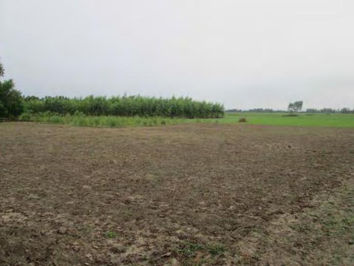
143 Bats Babui pakhi RoW, land without crop RoW, land without crop 118
 land")
 land")

144 RoW, wetland RoW, crop (jute) land RoW, crop (jute) land RoW, crop (maize) land Madaripur beel route River Madhumati River 119


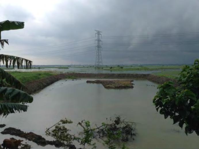
145 Direction to Madaripur Dhaka-Maowa high way Aminbazar-Meghnaghat 400 kv TL Residential Projects, Sreenagar 120


146 A consultation meeting with local people A consultation meeting with local people Chatal Mosque Bridge on Naria Road, Sariatpur Padma River Crossing Point for TL 121
147 Appendix 3 Finds Procedures in Case of Finds of Culturally Valuable Materials In the case of discovery of culturally valuable material: Stop work immediately following the discovery of any materials with possible archaeological, historical, paleontological, or other cultural value. Announce findings to project manager and notify to the Department of Archaeology under Ministry of cultural Affairs, GOB Protect artifacts as well as possible using plastic covers, and implement measures to stabilize the area, if necessary, to properly protect artifacts Prevent and penalize any unauthorized access to the artifacts Restart construction works only upon the authorization of the relevant authorities. Appendix 4 Seven Platforms Constructed in the Padma River - Associated Facility The 7 platforms which will carry the TL for the Project across the Padma River are being constructed as part of the Padma River Multipurpose Bridge Construction Project which is being directly funded by GoB. This project will extend communications across the Padma River and link the south west of the country to Dhaka. The project consists of the following elements: 1. Main bridge (6.15km long) and transition structures (bridge end viaducts); 2. River training works; 3. Bridge connecting approach roads (about 2.3km at Mawa left bank side and 12.8km at Janjira side) and associated structures 4. 6 other bridges, 14 culverts, 7 underpasses, and 11 junctions; 5. 2 Toll plazas (1 at Mawa and other at Janjira); 6. 2 Construction yards (area at Mawa = 81ha and at Janjira =78ha); 7. 2 Service areas (area at Mawa=27.2ha and at Janjira=63.7ha); 8. 4 Resettlement sites (2 at Mawa: RS02: Jashaldia with area 13.96ha, RS03: Kumarbhog with ha and 2 at Janjira: RS04: Paschim Naodoba with area 19.95ha and RS05: Bakhorerkandi with area 18.45ha, respectively); 9. Future provision of railway on the lower deck of the bridge; and 10. Provision of utility crossings (high pressure gas main, high voltage power TL and optical fiber telecommunication cable). The high voltage power TL in element 10 above is the Mongla to Aminbazar 400 kv TL which is the subject of the IEE document. Current Status of the Project: The DoE gave environmental clearance to the Padma Multipurpose Bridge Project in September This approval is on the basis of document BAN: Padma Multipurpose Bridge Project July 2010 which was prepared in accordance with ADB s Safeguard Policy Statement The DoE clearance letter and the latest renewal of the clearance in May 2015 are attached. Work began on the main bridge structure in November 2015 while the bridge approach roads were already more than 25% complete at that time. 122

148 Map of Padma Multipurpose Bridge Project Four alternative crossing points for the bridge were considered (see Map below). These were narrowed down to the two options Mawa-Janjira and Pauria-Goalundo. At the conclusion of the various physical, technical, hydraulic, transport, and socio-environmental studies, the Feasibility Study Team decided in favor of Mawa-Janjira for the construction of the proposed bridge. 123

149 Map of 4 Padma Bridge Crossing Alternatives Three crossing options were considered to support the 400 kv Mongla to Aminbazar TL which is part of the Project. The options were: 1. Support within the main bridge structure, 2. Support on conventional lattice towers attached to the main-bridge foundation, and 3. Support on free standing towers away from the bridge proper. The freestanding option was decided upon, to be located 2 km downstream away from the main bridge. Support for the TL immediately adjoining the main bridge has been rejected on aesthetic grounds. For the preferred 7 platform option, costs are also significantly lower. Installation of the TL away from the Bridge also avoids any possible future disruption to the operation of the Main Bridge. With the TL on the bridge, there had been concerns regarding the electromagnetic compatibility between the power line and the railway line signalling 124
150 systems. PGCB also indicated it did not support accommodation of the TL within the main bridge because of concerns regarding installation and maintenance. For all aspects of the Multipurpose Bridge Project acquisition and or requisition of land was required for construction of the various components of the project. The total land that has been acquired for various components is about 1,144 ha, of which ha (about 73.7%) is on the South or right bank (Shariatpur and Madaripur districts). In addition, 190 ha of charland is required for the transit/access channel and manoeuvrings of barge and cranes. Detailed resettlement plans have been formulated and put in place. There is extensive dredging work in the river for river training works and piling for the bridge, associated facilities and including the 7 piles and pads required for the transmission towers of the TL. Surface water quality in the river will deteriorate from increased turbidity during dredging. This will result from disposal of dredged materials during piling activities and local turbidity at drill cutter heads. Other sources of turbidity include materials used from superstructure formworks and other construction activities in or over water, and solid waste disposal. Increase in turbidity in the downstream water might cause significant damage to breeding and spawning of fish and may pose a threat to other aquatic species. Disposal of dredging materials, without proper management, on unhabitated Charland at downstream of the proposed bridge alignment could have significant impacts. Such impacts could include loss of vegetation, loss of habitats for migratory birds, benthos, snakes, insects etc. Dust pollution may also occur specially during dry period due to deposition of dredged materials on Charland. Further, due to frequent movement of construction vessels Charland will be eroded. The project has developed a waste management plan and a dredge material disposal plan. Dredge materials are extensively used in construction as borrow material for filing at bridges, construction yards and bridge approach roads. In some places fill material is stored in designated place prior to re-use. There is no exclusive habitat of any endangered species near the project site. However, the Padma River is a secondary habitat of 2 endangered species namely Shushuk (Dolphin) & Gangetic Gharial. Padma River is also an important migratory route for hilsa fish. Pile driving will have a significant impact on the Hilsa migration. The annual Hilsa migration has the potential to be affected by construction especially during piling. It is possible that project activities may cause temporary changes in migratory patterns during construction. Juvenile Hilsa migration at the bridge site predominantly takes place during March-May. Hilsa use the deep channels (>10m) for their migration and two such channels were identified in 2008 and 2009 bathymetric survey of the bridge alignment; both are close to the left bank. Any piling activity in the deep channels of the river during the hilsa migration period will hamper their migration pattern. No direct mitigation measures are considered as possible in the EIA report for temporary construction activities and disturbance of habitat, but compensation in the form of fish reserves or sanctuaries in the riverine zone in up and downstream areas have been provided for and a charland visitor centre will be established as mitigation. For the river piling work extensive mitigation measures will be employed to ensure sound impacts and interference with dolphins are minimized with exclusion zones defined during piling. Scaring tactics are to be used when dolphins are present. Piling is also restricted in the two deep 125
151 channels during the hilsa migration season which also coincides with the dolphin breeding season. The following procedure will be adopted: Gradually ramp up the sound levels to scare cetaceans away before piling proper commences, Use pingers upstream and downstream to chase away dolphins and other cetaceans, Monitor area for these creatures to ensure they are well away from the piling site scare them away if they are two close to the site using pingers. Compliance with SPS 2009 Originally the Multipurpose Bridge project was to be funded by international donors and the EIA was specifically undertaken in July 2010 for BBA to ADB s Safeguard Policy Statement Due diligence was undertaken with examination of the EIA report. A site visit and meetings took place with the Multipurpose Bridge staff in October 2015 (meetings with engineers, the Consultant Environmental Officer for the Padma Multipurpose Bridge along with the Project Director PGCB). Table of Compliance Conduct an Appropriate Environmental Assessment Examine Alternatives Carry out Meaningful Consultation with Affected People Implementation of EMP and disclose monitoring reports Develop a Grievance Redress Mechanism Compliance with SPS 2009 Full EIA undertake to ADB Standards in 2010 Approved under GoB Alternatives considered in EIA the EIA looked at three crossings for the bridge and two alternatives for the TL crossing Proper consultation and disclosure took place to comply with SPS Measures in the EMP and monitoring reports have been made to DoE, but compliance could not be determined as monitoring reports made to DoE not available as yet to egen consultants A combined grievance redress committee is defined in the EIA to address grievances in both social and environmental issues. 126 Gaps and follow up Monitoring Compliance Need to access BBA environmental monitoring reporting to NoC to judge if compliant in implementation Need BBA monitoring reports to judge if implementation is compliant Need reports from BBA to determine compliance
152 Environmental Health and Safety Plans and Emergency Response Plans Plans set down in the EIA Need reports from BBA to determine compliance The Bridge project has established its own Environmental Monitoring Unit and an independent panel of experts has been set up to oversee implementation of the EIA, EMP and monitoring plan and general good practice. Public consultation and EIA disclosure have been undertaken properly. A Grievance Redress Mechanism and Committee are in place. Resettlement Action Plans have been implemented to properly compensate land owners and villagers have been resettled at new settlement sites on the right bank of the Padma River. Environmental health and safety measures are in place along with an emergency response plan. 127
153 Padma Multipurpose Bridge Environmental Approval 128
154 129
155 130
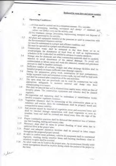
156 131
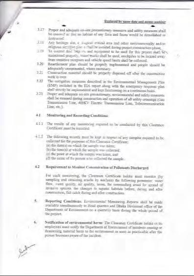
157 132
158 133
159 134
160 Appendix 5 Emergency Action Plan EMERGENCY ACTION PLAN For Mongla-Maowa-Aminbazar 400 kv Transmission Line and Aminbazar 400/230 kv Substation project Facility Address: DATE PREPARED: April 7,
161 EMERGENCY PERSONNEL NAMES AND PHONE NUMBERS DESIGNATED RESPONSIBLE OFFICIAL (Highest Ranking Manager at site, such as,, or ): Name: Phone: ( ) EMERGENCY COORDINATOR: Name: Phone: ( ) AREA/FLOOR MONITORS (If applicable): Area/Floor: Name: Phone: ( ) Area/Floor: Name: Phone: ( ) ASSISTANTS TO PHYSICALLY CHALLENGED (If applicable): Name: Name: Phone: ( ) Phone: ( ) Date / / 136
162 EVACUATION ROUTES Evacuation route maps have been posted in each work area. The following information is marked on evacuation maps: a) Emergency exits b) Primary and secondary evacuation routes c) Locations of fire extinguishers d) Fire alarm pull stations location e) Assembly points Site personnel should know at least two evacuation routes. 137
163 EMERGENCY PHONE NUMBERS FIRE DEPARTMENT: PARAMEDICS: AMBULANCE: POLICE: FEDERAL PROTECTIVE SERVICE: SECURITY (If applicable): BUILDING MANAGER (If applicable): 138
164 UTILITY COMPANY EMERGENCY CONTACTS (Specify name of the company, phone number and point of contact) ELECTRIC: WATER: GAS (if applicable): TELEPHONE COMPANY: Date: / / 139
165 EMERGENCY REPORTING AND EVACUATION PROCEDURES Types of emergencies to be reported by site personnel are: MEDICAL FIRE SEVERE WEATHER BOMB THREAT CHEMICAL SPILL STRUCTURE CLIMBING/DESCENDING EXTENDED POWER LOSS OTHER (specify) (e.g., terrorist attack/hostage taking) 140
166 MEDICAL EMERGENCY Call medical emergency phone number (check applicable): 1 Paramedics 2 Ambulance 3 Fire Department 4 Other Provide the following information: a. Nature of medical emergency, b. Location of the emergency (address, building, room number), and c. Your name and phone number from which you are calling. Do not move victim unless absolutely necessary. Call the following personnel trained in CPR and First Aid to provide the required assistance prior to the arrival of the professional medical help: Name: Phone: Name: Phone: If personnel trained in First Aid are not available, as a minimum, attempt to provide the following assistance: Stop the bleeding with firm pressure on the wounds (note: avoid contact with blood or other bodily fluids). Clear the air passages using the Heimlich Maneuver in case of choking. In case of rendering assistance to personnel exposed to hazardous materials, consult the Material Safety Data Sheet (MSDS) and wear the appropriate personal protective equipment. Attempt first aid ONLY if trained and qualified. Date / / FIRE EMERGENCY 141
167 When fire is discovered: Activate the nearest fire alarm (if installed) Notify the local Fire Department by calling. If the fire alarm is not available, notify the site personnel about the fire emergency by the following means (check applicable): 5 Voice Communication 6 Phone Paging 7 Radio 8 Other (specify) 142
168 Fight the fire ONLY if: The Fire Department has been notified. The fire is small and is not spreading to other areas. Escaping the area is possible by backing up to the nearest exit. The fire extinguisher is in working condition and personnel are trained to use it. Upon being notified about the fire emergency, occupants must: Leave the building using the designated escape routes. Assemble in the designated area (specify location): Remain outside until the competent authority (Designated Official or designee) announces that it is safe to re-enter. Designated Official, Emergency Coordinator or supervisors must (underline one): Disconnect utilities and equipment unless doing so jeopardizes his/her safety. Coordinate an orderly evacuation of personnel. Perform an accurate head count of personnel reported to the designated area. Determine a rescue method to locate missing personnel. Provide the Fire Department personnel with the necessary information about the facility. Perform assessment and coordinate weather forecast office emergency closing procedures Area/Floor Monitors must: Ensure that all employees have evacuated the area/floor. Report any problems to the Emergency Coordinator at the assembly area. Assistants to Physically Challenged should: Assist all physically challenged employees in emergency evacuation. 143
169 Date / / EXTENDED POWER LOSS In the event of extended power loss to a facility certain precautionary measures should be taken depending on the geographical location and environment of the facility: 2. Unnecessary electrical equipment and appliances should be turned off in the event that power restoration would surge causing damage to electronics and effecting sensitive equipment. 3. Facilities with freezing temperatures should turn off and drain the following lines in the event of a long term power loss. 1. Fire sprinkler system 2. Standpipes 3. Potable water lines 4. Toilets 4. Add propylene-glycol to drains to prevent traps from freezing 5. Equipment that contains fluids that may freeze due to long term exposure to freezing temperatures should be moved to heated areas, drained of liquids, or provided with auxiliary heat sources. Upon Restoration of heat and power: 6. Electronic equipment should be brought up to ambient temperatures before energizing to prevent condensate from forming on circuitry. 7. Fire and potable water piping should be checked for leaks from freeze damage after the heat has been restored to the facility and water turned back on. 144
170 CHEMICAL SPILL The following are the locations of: Spill Containment and Security Equipment: Personal Protective Equipment (PPE): MSDS: When a Large Chemical Spill has occurred: Immediately notify the designated official and Emergency Coordinator. Contain the spill with available equipment (e.g., pads, booms, absorbent powder, etc.). Secure the area and alert other site personnel. Do not attempt to clean the spill unless trained to do so. Attend to injured personnel and call the medical emergency number, if required. Call a local spill cleanup company or the Fire Department (if arrangement has been made) to perform a large chemical (e.g., mercury) spill cleanup. Name of Spill Cleanup Company: Phone Number: Evacuate building as necessary When a Small Chemical Spill has occurred: Notify the Emergency Coordinator and/or supervisor (select one). If toxic fumes are present, secure the area (with caution tapes or cones) to prevent other personnel from entering. Deal with the spill in accordance with the instructions described in the MSDS. Small spills must be handled in a safe manner, while wearing the proper PPE. Review the general spill cleanup procedures. Date / / STRUCTURE CLIMBING/DESCENDING EMERGENCIES 145
171 List structures maintained by site personnel (tower, river gauge, etc.): No. Structure Type Location (address, if applicable) Emergency Response Organization* (if available within 30-minute response time) Emergency Response Organization(s): Name Phone Number Name Phone Number (Attach Emergency Response Agreement if available) * - N/A. If no Emergency Response Organization available within 30-minute response time additional personnel trained in rescue operations and equipped with rescue kit must accompany the climber(s). 146
172 TELEPHONE BOMB THREAT CHECKLIST INSTRUCTIONS: BE CALM, BE COURTEOUS. LISTEN. DO NOT INTERRUPT THE CALLER. YOUR NAME: TIME: DATE: CALLER'S IDENTITY SEX: Male Female Adult Juvenile APPROXIMATE AGE: ORIGIN OF CALL: Local Long Distance Telephone Booth VOICE CHARACTERISTICS SPEECH LANGUAGE Loud High Pitch Raspy Intoxicated Soft Deep Pleasant Other Fast Distinct Stutter Slurred Slow Distorted Nasal Other Excellent Fair Foul Good Poor Other ACCENT MANNER BACKGROUND NOISES Local Foreign Race Not Local Region Calm Rational Coherent Deliberate Righteous Angry Irrational Incoherent Emotional Laughing Factory Machines Music Office Machines Street Traffic Trains Animals Quiet Voices Airplanes Party Atmosphere BOMB FACTS PRETEND DIFFICULTY HEARING - KEEP CALLER TALKING - IF CALLER SEEMS AGREEABLE TO FURTHER CONVERSATION, ASK QUESTIONS LIKE: When will it go off? Certain Hour Time Remaining 147
173 Where is it located? Building Area What kind of bomb? What kind of package? How do you know so much about the bomb? What is your name and address? If building is occupied, inform caller that detonation could cause injury or death. Activate malicious call trace: Hang up phone and do not answer another line. Choose same line and dial *57 (if your phone system has this capability). Listen for the confirmation announcement and hang up. Call Security at and relay information about call. Did the caller appear familiar with plant or building (by his/her description of the bomb location)? Write out the message in its entirety and any other comments on a separate sheet of paper and attach to this checklist. Notify your supervisor immediately. 148
174 SEVERE WEATHER AND NATURAL DISASTERS Tornado: When a warning is issued by sirens or other means, seek inside shelter. Consider the following: - Small interior rooms on the lowest floor and without windows, - Hallways on the lowest floor away from doors and windows, and - Rooms constructed with reinforced concrete, brick, or block with no windows. Stay away from outside walls and windows. Use arms to protect head and neck. Remain sheltered until the tornado threat is announced to be over. Earthquake: Stay calm and await instructions from the Emergency Coordinator or the designated official. Keep away from overhead fixtures, windows, filing cabinets, and electrical power. Assist people with disabilities in finding a safe place. Evacuate as instructed by the Emergency Coordinator and/or the designated official. Flood: If indoors: Be ready to evacuate as directed by the Emergency Coordinator and/or the designated official. Follow the recommended primary or secondary evacuation routes. If outdoors: Climb to high ground and stay there. Avoid walking or driving through flood water. If car stalls, abandon it immediately and climb to a higher ground. Hurricane: The nature of a hurricane provides for more warning than other natural and weather disasters. A hurricane watch issued when a hurricane becomes a threat to a coastal area. A hurricane warning is issued when hurricane winds of 74 mph 149
175 or higher, or a combination of dangerously high water and rough seas, are expected in the area within 24 hours. Once a hurricane watch has been issued: Stay calm and await instructions from the Emergency Coordinator or the designated official. Moor any boats securely, or move to a safe place if time allows. Continue to monitor local TV and radio stations for instructions. Move early out of low-lying areas or from the coast, at the request of officials. If you are on high ground, away from the coast and plan to stay, secure the building, moving all loose items indoors and boarding up windows and openings. Collect drinking water in appropriate containers. Once a hurricane warning has been issued: Be ready to evacuate as directed by the Emergency Coordinator and/or the designated official. Leave areas that might be affected by storm tide or stream flooding. During a hurricane: Remain indoors and consider the following: - Small interior rooms on the lowest floor and without windows, - Hallways on the lowest floor away from doors and windows, and - Rooms constructed with reinforced concrete, brick, or block with no windows. 150
176 CRITICAL OPERATIONS During some emergency situations, it will be necessary for some specially assigned personnel to remain at the work areas to perform critical operations. Assignments: Work Area Name Job Title Description of Assignment Personnel involved in critical operations may remain on the site upon the permission of the site designated official or Emergency Coordinator. In case emergency situation will not permit any of the personnel to remain at the facility, the designated official or other assigned personnel shall notify the appropriate offices to initiate backups. This information can be obtained from the Emergency Evacuation Procedures included in the Manual. The following offices should be contacted: Name/Location: Telephone Number: Name/Location: Telephone Number: Name/Location: Telephone Number: TRAINING The following personnel have been trained to ensure a safe and orderly emergency evacuation of other employees: 151
177 Facility: Name Title Responsibility Date 152
178 Appendix 6 Template for Environmental Monitoring Report Environmental Safeguard Monitoring Report Reporting Period Date {From Month, Year to Month, Year} {Month, Year} Title of the Project {Example: SRI: Green Power Development and Energy Efficiency Improvement Investment Program} Prepared by the {Executing Agency} for the Asian Development Bank This environmental safeguard monitoring report is a document of the borrower and made publicly available in accordance with ADB s Public Communications Policy 2011 and the Safeguard Policy Statement The views expressed herein do not necessarily represent those of ADB s Board of Directors, Management, or staff. 153
179 TABLE OF CONTENTS Page Executive Summary Brief status of environmental compliance during the coverage period 1.0 Introduction 1.1 Brief Project Description 1.2 Project Progress Status and Implementation Schedule 2.0 Compliance to National Regulations 2.1 Environmental Conservation Rules Compliance to Environmental Covenants from the ADB Loan Agreement 3.1 Schedule 5 Environment (prepare a matrix to show how compliance was achieved) 4.0 Compliance to Environmental Management Plan (Refer to the EMP of the Project) 5.0 Safeguards Monitoring Results and Unanticipated Impacts (Refer to the Environmental Monitoring Plan and document any exceedance to environmental standards (if any), or any unanticipated impact not included in the EMP and any correction action/measures taken) 6.0 Implementation of Grievance Redress Mechanism and Complaints Received from Stakeholders (Summary of any complaint/grievance and the status of action taken) 7.0 Conclusion and Recommendations 154
180 Initial Environmental Examination Bangladesh: Bangladesh Power System Enhancement and Efficiency Improvement Project (Component 3: Distribution System Upgrade, Rehabilitation, Extension, and Rural Electrification in BREB Service Areas Part 1) (Dhaka, Mymensingh, Chittagong, and Sylhet Divisions REB) Prepared by Bangladesh Rural Electrification Board, Government of Bangladesh for the Asian Development Bank.
181 CURRENCY EQUIVALENTS (as of 08/06/16) Currency unit Taka (Tk.) Tk1.00 = USD0.013 USD1.00 = BDT This initial environmental examination is a document of the borrower. The views expressed herein do not necessarily represent those of ADB's Board of Directors, Management, or staff, and may be preliminary in nature. Your attention is directed to the terms of use section on ADB s website. In preparing any country program or strategy, financing any project, or by making any designation of or reference to a particular territory or geographic area in this document, the Asian Development Bank does not intend to make any judgments as to the legal or other status of any territory or area.
182 Abbreviations ADB AEZ AIS BBS BEZ BMD BREB BWDB CEGIS CITES DAE DC DESCO DEPC DG DIA DoE DoF DoL DPP EA ECA EIA EMP EQS FAO FD Asian Development Bank Agro-ecological Zone Air Insulated Switchgear Bangladesh Bureau of Statistics Bio-ecological Zone Bangladesh Meteorological Department Bangladesh Rural Electrification Board Bangladesh Water Development Board Center for Environmental and Geographic Information Services Convention on International Trade in endangered species Department of Agricultural Extension Deputy Commissioner Dhaka Electricity Supply Company Limited Department of Environmental Pollution Control Director General Direct Impact Area Department of Environment Department of Fisheries Department of Livestock Development Project Proposal Executing Agency Environment Conservation Act Environmental Impact Assessment Environmental Management Plan Environment Quality Standards Food and Agriculture Organization Forest Department i
183 FGD FIDC FRSS GIS GIS GoB GRM HES HHs IEE IUCN JICA MDG MoEF MoU NCS NEMAP NGO NOC NWRD OMS PAPs PBS PCM PD PMU PGCB PPE PWD Focused Group Discussion Forest Industries Development Corporation Fisheries Resources Survey System Geographic Information Systems Gas Insulated Switchgear Government of Bangladesh Grievance Redress Mechanism Health Environment and Safety Households Initial Environmental Examination International Union for Conservation for Nature Japan International Cooperation Agency Millennium Development Goal Ministry of Environment and Forest Memorandum of Understanding National Conservation Strategy National Environment Management Action Plan Non-Governmental Organization No Objection Certificate National Water Resource Database Operation Management System Project Affected People (s) Palli Biddyut Samities People s Consultation Meeting Project Director Project Management Unit Power Grid Company of Bangladesh Ltd. Personal Protection Equipment Public Works Department ii
184 RP RCC RoW RS SCADA SPS SPC SRDI ToR TSP UNCED UNDP WB Resettlement Plan Reinforced Cement Concrete Right of Way Remote Sensing Supervisory Control and Safeguard Policy Statement Spun Pre-stressed Concrete Soil Resources Development Institute Terms of Reference Triple Super Phosphate United Nations Conference on Environment and Development United Nations Development Programme World Bank Weights and Measures o C - degree Celsius ft - foot ft 2 - square feet db(a) - decibel acoustic ha - hectare km - kilometer km/h - kilometer per hour kg - kilogram kv - kilo Volt m - meter m 3 - cubic meter m 3 /hr - cubic meters per hour mg/l - milligrams per liter mm - milimeter iii
185 m/s - meters per second MTPA - metric tons per annum MT - metric ton MW - megawatt ppm - parts per million ppt - parts per thousand km 2 - square kilometer rpm - revolutions per minute μg/m 3 - microgram per cubic meter Glossary Adverse Impact: An impact that is considered undesirable. Ambient Air: Surrounding air. Aquatic: Growing or living in or near water. Bangla: Bengali language. Baseline (or existing) Conditions: The baseline essentially comprises the factual understanding and interpretation of existing environmental, social and health conditions of where the business activity is proposed. Understanding the baseline shall also include those trends present within it, and especially how changes could occur regardless of the presence of the Project, i.e. the No-development Option. Bazar: Market. Beel: A back swamp or depression can be either perennial or seasonal. Beneficial Impacts: Impacts, which are considered to be desirable and useful. Biological Diversity: The variety of life forms, the different plants, animals and microorganisms, genes they contain and the ecosystems they form. It is usually considered at three levels: genetic diversity, species diversity and ecological diversity. Ecosystem: A dynamic complex of plant, animal, fungal and microorganism communities and associated non-living environment interacting as an ecological unit. iv
186 Emission: The total amount of solid, liquid or gaseous pollutant emitted into the atmosphere from a given source within a given time, as indicated, for e.g., in grams per cubic meter of gas or by a relative measure, upon discharge from the source. Endangered Species: Species in danger of extinction and whose survival is unlikely if the existing conditions continue to operate. Included among those are species whose numbers have been reduced to a critical level or whose habitats have been so drastically reduced that they are deemed to suffer from immediate danger of extinction. Environment Clearance: approval requirement before a project can proceed under the GOB Environmental Conservation Act 1985 Environmental Effects: The measurable changes, in the natural system of productivity and environmental quality, resultingfrom a development activity. Environmental Impact: An estimate or judgment of the significance and value of environmental effects for natural, socio-economic and human receptors. Environment Management Plan (EMP): A plan to undertake an array of follow-up activities which provide for the sound environmental management of a project/ intervention so that adverse environmental impacts are minimized and mitigated; beneficial environmental effects are maximized; and sustainable development is ensured. Environment Monitoring Plan: Provides a delivery mechanism to address the adverse environmental impacts of a project during its execution, to enhance project benefits, and to introduce standards of good practice to be adopted for all project works. Environmental Management: Managing the productive use of natural resources without reducing their productivity and quality. Erosion: Process in which wind and water removes materials from their original place; for instance, soil washed away from an agricultural field. Evaluation: The process of looking back at what has been really done or accomplished. Fauna: A collective term denoting the animals occurring in a particular region or period. Flora: All of the plants found in a given area. Habitat: The natural home or environment for a plant or animal. Household: A household is identified as a dwelling unit where one or more persons live and eat together with common cooking arrangement. Persons living in the same dwelling unit having separate cooking arrangements constitute separate household. Land Use: Types include agriculture, horticulture, settlement, pisciculture and Industries. v
187 Mauza: A Bangla word for the smallest government administrative area corresponding to village revenue unit. Mitigation: An action, which may prevent or minimize adverse impacts and enhance beneficial impacts. Negative Impact: Negative change from the existing situation due to the Project. Project: Distribution System Rehabilitation, Augmentation and Rural Electrification in BREB Service Areas project. Public Involvement / Public Consultation: A range of techniques that can be used to inform, consult or interact with stakeholders affected / to be affected by a proposal. Reversible Impact: An environmental impact that recovers either through natural process or with human assistance (e.g. cutting off fish migration by an embankment might be reversible at a later stage if a proper regulator is built). Stakeholders: Those who may be potentially affected by a proposal, e.g. local people, the proponent, government agencies, NGOs, donors and others, all parties who may be affected by the Project or to take an interest in it. Taka: Unit of Bangladeshi currency. Terrestrial: Living on land. Thana: Sub-district level of government administration, comprising several unions under district. Union: Smallest unit of local self-government comprising several villages. Upazila: Sub-district name. Upozila introduced in Zila: Bengali word for district. NOTE In this report, "USD" refers to US dollars. vi
188 Table of Contents Abbreviations... i Weights and Measures... iii Glossary... iv Table of Contents... vii List of Tables... xi List of Figures... xi List of Maps... xii List of Photographs... xii Executive Summary... 1 Chapter 1 Introduction and Methodology Background of the Environmental Study Objectives of the Project Scope of Work Objectives of the IEE Study Project Area Methodology Structure of the Report Chapter 2 Policy and Legislations Overview Organisations Related with Enforcement of Environmental Standards Ministry of Environment and Forest (MoEF) Department of Environment (DoE) Forest Department Related Other Organizations National Policies and Legislation Relevant to Environment Other Relevant Acts related to Environment The Bangladesh Wildlife Preservation Order (1973; amended to Act in 1974) The National Forest Policy (1994) Policy Related with Energy Development The Electricity Act, 1910 and Electricity Rules The Telegraph Act (1885) The Power Policy, vii
189 2.5.4 The Energy Policy (1996 updated 2004) The Industrial Policy (1999) Compliance with International Requirements Rio Declaration Convention on Biological Diversity, (1992) Wetlands of International Importance as Waterfowl Habitat, (1971) UN Convention on the Law of the Sea, Montego Bay, (1982) Others (Conventions and Agreements) Compliance with ADB Safeguard Policy Statement, ADB s Environment Safeguard Requirements - Policy Principles Compliance with BREB Health Environment and Safety (HES) Requirements Building Construction (Amendment) Act, 1990 & Rules Rules and Policies in Related Fields Chapter 3 Description of the Project Background of the Project Project Category Project Location Material Requirements Proposed Work in the Project Area Construction Works Work Schedule Chapter 4 Environmental and Social Baseline Condition Project Boundary Physical Environment Climate General Rainfall Humidity Sunshine Wind Speed Seismicity Noise Air Quality Water Resources Water Systems and Water Quality Storms Land Resources Agro-ecological zones viii
190 4.6.2 Land Use and Land Type Agriculture Resources Cropping Pattern and Cropping Intensity in the Project Area Ecology Biological Environment Bio-ecological Zoning Ecosystem Diversity Biodiversity Environmentally Sensitive Areas Socio-economic Resources Introduction Administrative Area Population and households Household size Age Structure and Age Dependency Literacy Disability Occupations and Livelihoods Housing Condition Sources of Drinking Water Sanitation Facilities Access to Electricity Chapter 5 Prediction of Environmental Impacts and Mitigation Potential Environmental Impacts and Mitigation Measures Water Quality and Water Bodies River Course, Natural Drainage and Irrigation Channels Interference with Roads and Road Crossing Construction Waste Land Use and Encroachment on Land Construction Noise, Dust and Vibration Soil Quality Crop Production Terrestrial Vegetation Wildlife Habitat Loss of Houses, Crops and Human Activities Waste Impacts Including Hazardous Waste Impacts from Project Workforce Employment Opportunities and Income Generation Industrial and Economic Development Human Safety Impact Screening Chapter 6 Analysis of Alternatives ix
191 Chapter 7 Information Disclosure, Consultation and Participation Introduction Identification of Stakeholders Approach for Public Consultation Public Consultation Meetings/Focus Group Discussions and PBS Meetings Findings and Issues Raised from Discussions and Meetings Chapter 8 Grievance Redress Mechanism (GRM) Chapter 9 Environmental Management and Monitoring Plans Mitigation and Remediation Measures Institutional Requirements and Monitoring Plan Budget for the Environmental Management Plan (EMP) Chapter 10 Conclusions APPENDIX 1 VILLAGE MEETINGS AND PBS MEETTINGS APPENDIX 2 TEMPLATE FOR ENVIRONMENTAL MONITORING REPORT101 x
192 List of Tables Table Summary of Project Activities... 4 Table ADB s Environment Safeguard Requirement Table Environmental Laws, Regulations and Standards of Bangladesh Table Project Activity in PBS and Upazilla Councils Table Proposed Project Work by PBS Locations Table 4.1 -Average Monthly Rainfall in the Project Area Table Number of Normal Rainy Days in the Project Area Table Normal Minimum Temperature Table Normal Maximum Temperature Table Monthly Normal Humidity (%) in the Project Area Table Average Wind Speeds (m/s) in the Project Area Table Standard Value (dba) for Noise Table Standards of Ambient Air Quality Table Soil Characteristics of AEZs in the Project Area Table Plants Species Growing in the Project Area Table Ecologically Sensitive Areas in the Project Area Table Administrative Areas inside the 42 PBS Project Areas Table Demographic Characteristics of the Project Area Table Household Size in the Project Area Table Population Distributions by Different Age Groups Table Literacy Rates by Each Division and for the Project as a Whole Table Distribution of Population by Type of Disability Table Occupation and Livelihood by Division and for Project Area Table Type of Housing Structure in the Project Area Table Sources of Drinking Water Table Access to Sanitation Facilities in the Project Area Table Access to Electricity Table Consultation Meeting Places Table List of Officials Consulted Table Environmental Management Plan Table Monitoring Plan Table Budget for the Environmental Management Plan List of Figures Figure Steps of Initial Environmental Examination (IEE)... 9 Figure DoE Environmental Clearance Procedures Figure Monthly Average Rainy Days at Teknaf BMD Station Figure Monthly Average Rainy Days at Sylhet BMD Station Figure Monthly Average Humidity at Teknaf BMD Stations xi
193 Figure Average Daily Sunshine Hours at Dhaka BMD Station Figure Average Daily Sunshine Hours at Sylhet Division Figure Average Daily Sunshine Hours at Sitakunda, Chittagong Division Figure Wind Speed at Madaripur BMD Station Figure Wind Speed at Chittagong BMD Station Figure Type of Housing Structure in the Project Area Figure Sources of Drinking Water in Dhaka and Mymensingh Divisions Figure Access to Sanitation Facilities in Dhaka, Mymensingh and Sylhet List of Maps Map Map of the Project PBSs... 8 Map Earthquake Prone Area of Bangladesh Map Agro-ecological Zones in Bangladesh Map Land Use Zones of Bangladesh Map Bio-ecological Zones of Bangladesh Map Ecologically Critical and Sensitive Areas of Bangladesh List of Photographs Photo 3.1: Dhaka PBS Photo 3.2: Dhaka PBS Photo 3.3: Narayngonj PBS Photo 3.4: Narsingdi PBS Photo 3.5: Gazipur PBS Photo 3.6: Narayngonj PBS Photo 3.7: Dhaka PBS Photo 3.8: Dhaka PBS Photo 4.1: Jute field in Project Area Photo 4.2: Maize field in Project Area Photo 4.3: Educational Institution in the ProjectArea Photo 4.4 & 4.5: Housing Condition in the Project Area Photo Typical Sources of Drinking Water xii
194 Executive Summary The Bangladesh Rural Electrification Board (BREB) intends to improve the electricity supply to existing consumers and extend supply to new customers in the rural areas of Bangladesh. The Distribution System Rehabilitation, Augmentation and Rural Electrification in BREB Service Areas project (the Project ) in Dhaka, Mymensingh, Chittagong and Sylhet Divisions is designed to meet these goals. Asian Development Bank (ADB) is considering lending funds to the GoB for the Project. According to the Environment Conservation Act 1995 and Environment Conservation Rules 1997 of Bangladesh, distribution projects are categorized as Red Category projects which require Initial Environmental Examination (IEE) for Site Clearance and Environmental Impact Assessment (EIA) for Environment Clearance. Therefore, in order to obtain Site Clearance and Environmental Clearance from the Department of Environment (DoE), BREB is required to undertake IEE and EIA studies. BREB is in the process of employing consultants to undertake the necessary environmental clearance from DoE. The Project also needs to comply with ADB s Safeguard Policy Statement (SPS) In view of the fact that this is a local electricity distribution project with relatively small scale temporary impacts, based on SPS 2009, the project is category B requiring an IEE. The Project plans to construct 6,465 km of new distribution lines and also rehabilitate/upgrade/conversion of 20,535 km of existing distribution lines (operating at 33 kv and voltages below) in 42 Palli Biddyut Samities (PSBs) covering about half the country and construction of new and extension of existing office and accommodation buildings in head office compounds of several PBSs. A second project covering the remaining 35 PSBs in the western part of the country has also been prepared. The planned new lines (400 V or 230 V) will be short extensions of the existing network. The rehabilitate/up-grade/conversion element of the Project will be mainly on existing lines operating at 11 kv or lower voltages, with some work on 33 kv lines. Impacts from the Project will be minor. Work consists of short extensions no more than one hundred meters in extent. For the existing lines old infrastructure will be replaced with new poles, conductors and insulators. Most of the work will be along road sides in existing Rights of Way (RoW), and there may be disruption of traffic during installation of lines and rehabilitation with the activity of workers and movement of support vehicles. There may be need to cut back some trees. Construction of new and extension of existing PBS offices and residential buildings will be on land owned by the PBSs in head office compounds with little environmental impacts. Project activities do not cross any protected areas or protected forests or sensitive areas and there will be no impacts on terrestrial fauna and flora. There appear to be no issues of displacement of people or impacts on property. Flexibility in location of new poles means that there will be no significant impact from the new lines. The minor impact of noise and any temporary traffic disruption during implementation of the Project are short lived and can be managed. The upgrading and rehabilitation work and the need for ongoing servicing of the network, particularly the thousands of pole mounted transformers, will require PBS authorities to have in place procedures and mechanisms to handle waste materials wood, ceramic insulators, conductor and copper wire on a large scale. Transformers use significant amounts of oil and there is need to replace, recycle and dispose of significant quantities of oil. Procedures will also 1
195 be in place for the handling and handling/disposal of hazardous waste in the form of all timber poles treated with creosote and other preservative chemicals. The Environmental Management Plan (EMP) included in this IEE along with the monitoring plan, will assist project implementation and during ongoing operations at the PBS authorities. The project is mainly involved in replacement and refurbishment of existing lines. There is limited scope for consideration of alternatives; in the planning of new extension distribution lines existing RoW have been preferred to lines crossing open farm land. Three public consultation meetings took place with local people in 2015 at three different PBSs at which 125 people attended. Meetings with local people during field trips to the site indicated that local people are very happy with the Project which in many cases will give them electricity for the first time. People felt that improvement in security of supply would also give a boost to economic development and the Project is seen by local people as very positive. A Grievance Redress Mechanism (GRM) will be established at the start of the Project. The GRM will link into the established complaints system already established in the PBS and will handle complaints regarding RP and EMP matters. BREB has already set up a Project Management Unit (PMU) to implement existing projects funded by other unilateral and multi-lateral funding agencies, and the PMU will be responsible for the overall implementation of the EMP and the monitoring plan. Costing for environmental mitigation measures will be included in construction contracts. Funds are included (Tk 6 million) for training of BREB staff at headquarters and for training of PBS staff who will be responsible for implementation of the Project and ongoing project monitoring. Tk 30 million is identified for inclusion in BREB recurrent budget for monitoring of the implementation of the IEE. The implementation of this IEE and the associated EMP will meet the need to comply with ADB s SPS
196 Chapter 1 Introduction and Methodology 1.1 Background of the Environmental Study 1. In FY2015 1, the Bangladesh power generating system serving the national grid had an installed capacity of 10,939 MW, served a peak demand of 7,817 MW 2, and delivered 43,738 3 GWh to the Power Grid Company of Bangladesh (PGCB) transmission network. Bangladesh Power Development Board (BPDB) as the single buyer, purchases generated electricity from all generating facilities comprising independent power producers, BPDB s subsidiary generating companies, BPDB s own power plants, and from India through the cross border transmission link 4. Electricity is delivered to distribution utilities such as Dhaka Electric Supply Company (DESCO) and Dhaka Power Distribution Company (DPDC) in Dhaka, and to BREB in rural areas for distribution. BPDB too serves as a distribution utility in urban areas of Bangladesh, except Dhaka. 2. Access to electricity was reported to be 72% by mid-june The Government of Bangladesh plans to provide electricity to all households by year The per capita electricity consumption including estimated consumption from captive generation with industries, was 371 kwh 5 in FY2015, which is low compared with other countries in South Asia 6, indicating that power generation, transmission and distribution facilities require significant capacity additions as Bangladesh grows into the middle income status. With the increasing customer base and through the increased demand from customers for household, commercial and industrial activities, the peak demand in Bangladesh is expected to continue increasing in the medium term as Bangladesh transitions to middle income country status. Several major power generation projects and regional cooperation projects are planned to add to generation capacity while PGCB is planning several 400 kv transmission lines to link various parts of the country including Dhaka and Khulna, two major load centres in the country. Potential introduction of 765 kv transmission line is also under consideration. 3. Sales by distribution utilities to end-use customers in FY2015 were 39,600 GWh, indicating that the country s transmission and distribution loss was about 13.02% of generation. The reported distribution loss was 10.82%, which indicates room for improvement. Furthermore, 1 The fiscal year (FY) of the Government ends on 30 June. FY before a calendar year denotes the year in which the fiscal year ends, e.g., FY2014 ends on 30 June Annual Report, Bangladesh Power Development Board (BPDB), FY Energy input to the transmission network. When generation served directly into the networks of Palli Bidyuth Shamiti (PBS) is included, the total generation was 45,836 GWh. 4 A few smaller power plants sell direct to BREB/PBSs. 5 Seventh five-year plan, FY2016-FY2020, Planning Commission, Government of Bangladesh. Electricity sales from the grid was 251 kwh/person in FY2015, as stated in the Annual Report, Bangladesh Power Development Board (BPDB), FY Per capita sales reported in 2015 by other countries in the region (in kwh per year) were Bhutan: 977, India: 760, Maldives: 530, and Sri Lanka: 572 3
197 the distribution system requires rehabilitation and upgrades to serve the growing demand in existing service areas and to replace ageing assets. 4. The ADB Bangladesh Power System Enhancement and Efficiency Improvement Project aims to improve electricity transmission and distribution in the country. A summary of the overall project activities is provided in Table 1.1. Project Output and Description Table Summary of Project Activities Length or capacity Component 1: PGCB s transmission system development in Southern Bangladesh 1.1 Construction of the new 400 kv double circuit transmission line from Aminbazar to Mongla 1.2 Augmentation and upgrade of the exiting 230 kv/132 kv substation at Aminbazar to 400 kv/ 230 kv/132 kv Additional information 174 km The line will use quad-finch 7 Component 2: Service improvement in DESCO service areas 2.1 Establishment of a SCADA system in the DESCO service area conductor 3 x 520 MVA Three new 400 kv/230 kv transformers will be installed All 33/11 kv distribution substations will be monitored and remotely controlled Component 3: Distribution system rehabilitation, upgrade, extension and rural electrification in BREB service areas 3.1 Rehabilitation and upgrading of 20,535 km of 33 kv,11 kv and 400 V distribution lines, and expansion of the distribution network by 6,465 km at 42 PBSs in Dhaka, Mymensingh, Chittagong and Sylhet Divisions 3.2 Rehabilitation and upgrading of 18,000 km of 33 kv, 11 kv and 400 V distribution lines, and expansion of the distribution network by 5,500 km at 35 PBSs in Rajshahi, Rangpur, Khulna and Barisal Divisions 27,000 km The expanded distribution network will add 500,000 new customers, with a potential to serve a further 500,000 new customers 23,500 km The expanded distribution network will add 450,000 new customers,, with a potential to serve a further 500,000 new customers Component 4: Technical assistance for project development, regulatory initiatives, and capacity building 4.1 Feasibility studies and new At least four renewable energy parks to be 7 Four wires of type Finch bundled together to carry current. 4
198 Project Output and Description business models for wind and solar parks 4.2 Transmission planning, project preparatory support for PGCB, and renewable integration studies/protocol development 4.3 GIS-based management system installed in ten PBSs 4.4 Pre-feasibility study on small scale LNG for industries/electricity production 4.5 Implementation of tariff methodology, energy auditing and efficiency improvement procedures for power plants 4.6 Analysis of transmission and distribution losses and establishing regulatory loss targets 4.7 Energy efficiency of buildings: establishment of a building energy efficiency rating system 4.8 Promoting good governance in power sector to provide better service delivery 4.9 Capacity building in energy sector planning and management, to provide better service delivery Length or Additional capacity information provided with feasibility studies and business models for development Preparation of a 10-year rolling transmission development and investment plan, feasibility and project preparatory studies for grid development, analysis of impacts of grid integration of intermittent-resource-based generation and development of protocols Design and implementation of a comprehensive GIS 8 -based network planning and management system for two PBSs (Phase I) and an additional eight PBSs (Phase 2) and operational Pre-feasibility study on the potential demand and delivery mechanisms for small scale LNG for industrial and power generation applications (i) Strengthening of tariff filing and determination process, introduction of regulatory accounting procedures and manual, tariff filing formats (ii) Establishing an energy auditing and efficiency improvement procedure for power plants. Disaggregation of technical and commercial losses in each transmission and distribution entity, and establishing annual loss targets for Part 1: Capacity building and conducting rating assessments Part 2: implementation of solar PV integration to buildings Sector reviews, project design and implementation support, support for sector planning and management Capacity building on renewable energy development, grid integration, GIS development, LNG supply development and use 5. Component 3 indicated in Table 1.1 is distribution system rehabilitation, augmentation and rural electrification in BREB service areas. This component is divided into two subcomponents, in term of the geographic categorization of PBSs. (i) Dhaka, Mymensingh, Chittagong and Sylhet areas, covering 42 PBSs, and (ii) Rajshahi, Rangpur, Khulna and Barisal areas, covering 35 PBSs. Under each subcomponent, the project largely focuses on (a) rehabilitation and upgrading of existing 33 kv, 11 kv and 400 V lines (new customers not directly added but owing to higher line capacity, new customers can be supported in downstream distribution networks), and (b) extension of 400 V or 230 V distribution lines, to serve new customers. This study relates to the first subcomponent (component 3.1) in the 42 8 Geographic Information System 5
199 PBSs located in Dhaka, Mymensingh, Chittagong and Sylhet. Both components have construction of new and extension of existing office and residential buildings within head office compounds of several PBSs which have no environmental impacts, and hence have not been considered for detailed study during the IEE. 6. Distribution lines of PBSs have been built since 1970s, and until 1996, wood poles were exclusively used. These wood poles have a limited life span, typically 20 years. Therefore, a large share of wood poles in service require replacement. Additionally, wooden cross-arms, too, require to be replaced. Owing to the growing demand on existing lines, upgrading the existing electrical conductor to one with a larger cross sectional area, is often required. Furthermore, a second circuit on existing poles is warranted in certain areas to serve the additional demand, without building new lines by opening new line corridors that impact land use. Line extensions too would be required, particularly for 11 kv lines and 400 V lines, to serve customers in interior villages. This project component plans to address the complete range of issues with distribution lines in all PBSs in Bangladesh. The work would involve rehabilitation, strengthening and upgrading of (i) 33kV lines transferring power from PGCB substations to BREB substations, (ii) 11 kv lines serving industrial and household customer areas, (iii) providing new transformers to serve household, small commercial and small industrial customers, and (iv) extension of 400 V lines to serve new customers as well as to improve service quality to existing customers. 7. The Project requires an EIA according to GoB environmental regulations as it ranks as a red project under Department of Environment (DoE) Regulations. BREB is in the process of recruiting consultants (May 2016) to undertake the necessary IEE and EIA and obtain the necessary project approval from the DoE. 1.2 Objectives of the Project 8. The objective of the Project is to improve the quality of electricity supply to existing consumers, to allow capability for consumer growth and to minimize system losses in 42 PBS authorities. This will be achieved with the construction of 6,465 km of new distribution lines and the rehabilitate/up-grade/conversion of 20,535 km of existing distribution lines (maximum 33 kv) as indicated in Table - 1. Table Length of Lines in the Project by Voltage and Type Existing Lines Rehabilitation/ Upgrade/ Conversion New Line (Short Extension of about Hundred Meters) 33 kv 11 kv 440/ 240 V 11 kv 905 km 12,510km 7,120 km 6,465 km 9. The broad objective is, therefore, to provide more access to electricity, and thereby boost economic development and reduce poverty in the rural areas. The Project aims to connect 500,000 new consumers. This will result in improving the financial soundness of the concerned PBS with increased income generation from new consumer connections. The Project should contribute to the national economy through added production in the agriculture and 6
200 industry sectors, with the expansion of industries and business, and by the creation of additional employment. 1.3 Scope of Work 10. The scope of work for the IEE study involves environmental assessment of the activities involved in the extension of the network in the 42 PBS authorities which cover four administrative divisions of Bangladesh (Dhaka, Mymensingh, Chittagong and Sylhet). The work involved includes thousands of small sub-projects spread across these four divisions, but the maximum extent at any one location for new works involves only about one hundred meters, at most. 11. The IEE study also provides information on the baseline environmental condition (physical, biological and social environment) of the project area. 12. The IEE identifies environmental and social components likely to be affected by the Project and defines potential impacts. Public consultation was conducted to obtain the opinions of locally affected people in the project area. An Environmental Management Plan (EMP) and Environmental Monitoring Plan and institutional arrangements for future monitoring are developed in the IEE. 1.4 Objectives of the IEE Study 13. According to the Environmental Conservation Act 1995 and Environmental Rules 1997, electricity distribution projects fall under the red category. Red category projects require EIAs to be preceded by IEEs. As this project falls under the red category it is required to undertake an IEE which is a pre-condition for obtaining Environmental Clearance from the DoE. See Chapter 2 for details of the IEE/EIA process. 14. Irrespective of GoB regulations, the proposed project falls under Category B according to the ADB guideline with the need for IEE. This document is prepared by e.gen consultants to fulfill ADB requirements under ADB s SPS Project Area 15. The location of the Project is shown in Map 1.1. The 42 PBSs are within four administrative divisions shown on the map which cover 65,326 km 2 of the 147,570 km 2 which make up the country. The Project involves hundreds of smaller subprojects throughout the project area 7

201 Map Map of the Project PBSs 8
202 1.6 Methodology 16. IEE is an initial examination for estimating the potential environmental impacts of a proposed project. IEE is undertaken based on preliminary information available at hand or on information which can be readily obtained through an environmental reconnaissance. The IEE study undertaken for this project specifically follows the steps described below. Figure Steps of Initial Environmental Examination (IEE) i. Analysis of the Project Components 17. All aspects of distribution line construction and rehabilitation works and activities were examined prior to developing a checklist for further analysis. ii. Preparation of Checklist 18. A checklist of potential environmental parameters was prepared based on various guidelines of different agencies such as DoE, World Bank, ADB and Japan International Corporation Agency. The checklist was used to identify potential impacts. iii. Initial Screening and Baseline Survey 19. The list of parameters identified was shortened to focus on significant effects. Also data was collected from all possible secondary sources. Environmental and socio-economic data from different sources (e.g. Bangladesh Bureau of Statistics (BBS), DoE, Bangladesh Meteorological Department (BMD), Bangladesh Water Development Board (BWDB), Agro- 9
203 climatic survey of Bangladesh and other IEE reports) were collected to prepare the baseline environmental and socio- economic profile of the study area. iv. Scaling of Impacts 20. A short description of existing physical, social and environmental conditions of the project sites was prepared and the impacts of project intervention on the physical, environmental and social components were graded in order to identify important components. v. Identification of Enhancement and Mitigating Measures 21. Enhancement and mitigating measures for beneficial and adverse effects respectively were defined. vi. Preparation of IEE Report 22. Finally an IEE report was prepared following standard chapter outlines. 1.7 Structure of the Report 23. The IEE report is structured as follows: Chapter 1: Introduction and Methodology: The introduction chapter presents a brief overview of the assignment along with its background, objectives, scope of work, methodology etc. Chapter 2: Policy and Legislation: Outlines the Policy and Legislation with respect to environmental issues. Chapter 3: Project Description: Describes the proposed project interventions including background, project category, need for the Project, location, size and magnitude of operation. Chapter 4: Description of Environmental and Social Baseline: Presents a description of the environmental baseline condition (socio-economic, physical and biological) of the project area. Chapter 5: Prediction of Environmental Impacts and Mitigation: Deals with the environmental impacts of the proposed project and possible mitigation measures. Chapter 6: Analysis of Alternatives: This section provides brief discussions on alternative options the Project. Chapter 7: Information Disclosure, Consultation and Participation: Mainly describes public opinion of the Project as well as major problems, impacts and any solutions recommended for the Project. Chapter 8: Grievance Redress Mechanism: This chapter set out the mechanisms for resolving complaints about environmental performance. Chapter 9: Environmental Management and Monitoring Plan: Defines the EMP and formulates the monitoring program of the Project and institutional arrangements. Chapter 10: Conclusions: This chapter presents the findings, conclusion, and recommendations of the report. 10
204 Chapter 2 Policy and Legislations 2.1 Overview 24. The implementation and construction of this Project by the BREB requires strict compliance with laws, rules and regulations pertinent to the environment. In Bangladesh the DoE is responsible for ensuring the application of environmental laws and issuance of necessary clearances. 25. The procedures and requirements for EIA under the power sector are dictated by the Environment Conservation Act of 1995, which introduced a requirement for any proposed "industrial unit or project" to obtain prior approval from the DoE. 26. The Environment Conservation Act has classified projects to be assessed (by the DoE) in four categories (green, amber A, amber B, and red). Power sector development projects are allocated to the red category, which triggers an automatic requirement for an IEE followed by a full EIA. Subject to a satisfactory review of the environmental assessment, the DoE issues an authorization for the project to proceed. The authorization consists of two parts: a "site clearance", which gives approval to the site proposed for the project and "Environmental Clearance", which approves the content of the project. 27. The BREB, as project proponent, is responsible for carrying out an EIA study of the proposed project. BREB has the responsibility to administer the environment assessment process through its PMU and consultants, review the findings of consultants, and submit the documents to the DoE for their review. 28. A key requirement of the EIA for projects classified in the amber and red categories is an EMP. The function of the EMP is to enable the project proponent (BREB) to show the DoE how it will deliver the environmental performance assessed in the EIA (for which DoE approval is sought). The EMP must describe in detail organization and management responsibilities, give details of how mitigation measures identified in the EIA will be implemented and explain how monitoring will be carried out. 29. Possession of a "clearance'' from the DoE does not relieve the developer of a project from the requirement to comply with other environmental regulations. In particular, the Bangladesh National Environment Quality Standards (EQS) for industrial effluent have been set and compliance is mandatory. In addition, there are statutory instruments applicable to power sector development projects, which are not primarily environmental in nature, but, which influence environmental impacts. Compliance with such statutory instruments is mandatory Procedure for Obtaining Site/Environmental Clearance Requirement for IEE Reports 30. All industries and projects in the red category must conduct IEEs, which help in understanding the potential extent of environmental changes as a result of the project. The IEE 11
205 finds ways to mitigate negative impacts by considering available information, past experience or standard operating practices. The steps for conducting IEEs are as follows: Collection of baseline information in respect of a project and the environmental setting of the project and its site. Setting of boundaries of an IEE by identifying the significant issues. Impact assessment suggesting mitigation measures, development of an EMP, and discussion of alternative sites for the project or other project modifications. In the event the IEE of the project or industry reveals that further investigation is required to be carried out, the sponsors will have to conduct a detailed EIA Procedure 31. After completion of the IEE Report the project proponent should apply to the DoE in the prescribed format for Site/Environmental Clearance. The application for Environmental Clearance for a project classified in the red category should be accompanied by the following documents: Feasibility study report of the industry/project IEE report An no objection certificate from the local authorities concerned Pollution minimization plan including emergency plan for mitigation of adverse environmental impacts Outline of relocation plans (where applicable) Other information as deemed necessary 32. The Environment Conservation Rules give the Director General of the Department DoE the discretion to issue Environmental Clearance directly without issuing any site clearance to any industry or project if he (the Director General) finds appropriate reason for doing so. 33. As the proposed construction of the Project falls under the "red" category, all necessary requirements mentioned above should be adopted by BREB for the Project. Figure 2-1 shows the activities involved in obtaining Environmental Clearance from the DoE. 12

206 Figure DoE Environmental Clearance Procedures APPLICATION TO DoE RED The application should enclose: - Feasibility Study Report (for proposed industry/ project); - Initial Environmental Examination Report and Environmental Impact Assessment Report; - Environmental Management Plan; - An NOC; - Pollution Minimization Plan; - Outline of Relocation Plan, etc. Obtaining Site Clearance Applying for Environmental Clearance Obtaining EnvironmentalClearance Clearance subject to annual renewal NOC Note: = No Objection Certificate, usually obtained from local government. 1. These requirements vary from those of the DoE (1997) in requiring EMPs for proposed, as well as current, projects. 2. Procedure of obtaining Environmental Clearance: for green category projects the gestation period for granting Environmental Clearance has been fixed at within 15 days; for amber A, amber B and red category projects at first Location Clearance and thereafter Environmental Clearance will be granted. The gestation period for Location Clearance is within 30days for amber A, and within 60 days for amber B and red category projects. Source: Adapted from the Environmental Guidelines for Industry (DoE, 1997) 13
207 2.2 Organisations Related with Enforcement of Environmental Standards 34. The roles and responsibilities of various ministries and departments involved in the enforcement of environmental requirements are described below: Ministry of Environment and Forest (MoEF) 35. The Ministry of Environment and Forest (MoEF) is the key government institution in Bangladesh for all matters relating to national environmental policy and regulatory issues. Realizing the ever-increasing importance of environmental issues, the MoEF was created by replacing the Ministry of Agriculture and Forest in 1989 and is at present a permanent member of the Executive Committee of the National Economic Council. This group is the major decision-making body for economic policy issues and is also responsible for approving all public investment projects. The MoEF oversees the activities of the following technical/implementing agencies: Department of Environment (DoE) Forest Department (FD) Forest Industries Development Corporation (FIDC) Department of Environment (DoE) 36. In order to expand the scope of environmental management and to strengthen implementation powers, the GoB adopted the Environmental Pollution Control Ordinance in The ordinance provided for the establishment of an Environmental Pollution Control Board, which was assigned with the responsibility of formulating policies and proposing measures for their implementation. In 1982, the Pollution Control Board was renamed as the Department of Environmental Pollution Control. Six divisional offices were established in Dhaka, Chittagong, Khulna, Barisal, Sylhet and Rajshahi. 37. A special presidential order renamed the Department of Environment Pollution Control as the Department of Environment (DoE) and placed it under the newly formed MoEF in The DoE is headed by a Director General (DG). The DG has complete control over the DoE. The power of the DG, as given under the Act, is outlined as follows: The DG has the power to close down activities considered harmful to human life or the environment. The operator has the right to appeal and procedures are in place for this. However, if the incident is considered an emergency, there is no opportunity for appeal. The DG has the power to declare an area affected by pollution as an ecologically critical area. The DoE governs the type of work or process, which can take place in such an area. Before undertaking any new development project, the project proponent must take an Environmental Clearance from the DoE. The procedures to take such clearance are in place. Failure to comply with any part of the Environment Conservation Act (ECA) 1995 may result in punishment by a maximum of 5 years imprisonment or a maximum fine of Tk. 100,000, or both. 14
208 2.2.3 Forest Department 39. This Department under the MOEF is responsible for the protection and management of all reserve forests in the country. Department personnel extend down to the union level in areas where there are reserve forests. The Department has recently started some agro forestry programs and its officers are also responsible for the protection of wildlife in the forests Related Other Organizations 40. There are several other organizations, which have certain social and environmental functions. These organizations include: Ministry of Land: Land Reform and Land Acquisition Directorate Ministry of Water Resources: Bangladesh Water Development Board (BWDB) Ministry of Fisheries and Livestock: Directorate of Fisheries 2.3 National Policies and Legislation Relevant to Environment 41. National Strategies, Policies, Acts and Rules related with the environment include the following: Environment Pollution Control Ordinance, 1977 Environmental Quality Standards for Bangladesh, 1991 National Conservation Strategy (NCS) 1992 Environment Policy (1992) National Environment Management Action Plan (NEMAP) 1995 Environment Conservation Act (1995) Environment Conservation Rules (1997) 2.4 Other Relevant Acts related to Environment The Bangladesh Wildlife Preservation Order (1973; amended to Act in 1974) 42. The Bangladesh Wildlife (Preservation) Order 1973 and amended to Act 1974 provides for the preservation, conservation and management of wildlife in Bangladesh. The earlier legislations on wildlife preservation, namely, the Elephant Preservation Act, 1879, the Wild Bird and Animals Protection Act, 1912, and the Rhinoceros Preservation Act, 1932 have been repealed and their provisions have been suitably incorporated in this law The National Forest Policy (1994) 43. The National Forest Policy of 1994 is the amended and revised version of the National Forest Policy of 1977 in the light of the National Forestry Master Plan. The major target of the policy is to conserve the existing forest areas and bring about 20% of the country's land area under the forestation program and increase the reserve forest land by 10% by the year
209 through coordinated efforts of government organizations, non-government organizations and active participation of the people. 2.5 Policy Related with Energy Development The Electricity Act, 1910 and Electricity Rules This Act amended the laws relating to the supply and use of electricity. Under this act, any person can obtain a license to supply energy and lay down or place electricity supply lines for the conveyance and transmission of electricity. The licensee can open and break up the soil and pavement of any street, railway or tramway and can lay down any line or do other work near other utility services (gas, telecommunication, water, sewer, etc.), provided prior permission is taken from respective authorities, as stated in Section of this Act. 45. According to Section 19 (1) of this act, the licensee shall give full compensation for any damage, detriment or inconvenience caused by him or by anyone employed by him. 46. Sub-section (1) of Section 51 of the Electricity Rules, 1937 advises that a licensee should take precautions in laying down electricity supply lines near or where any metallic substance or line crosses in order to avoid electrocution The Telegraph Act (1885) 47. Under Sections 10-19, Part III (Power to Place Telegraph Lines and Posts), the government can build poles and towers on public land without giving any land compensation The Power Policy, As with the Petroleum Policy, this is presently an integral part of the National Energy Policy It has different policy statements on a whole range of issues including demand forecast, long-term planning and project implementation, investment and lending terms, fuels and technologies, electricity supply to the west zone, isolated and remote load centers, tariff, captive and stand by generation, system loss reduction, load management and conservation, reliability of supply, system stability, load dispatching, institutional issues, private sector participation, human resource development, regional/international cooperation, technology transfer and research program, environment policy and legal issues The Energy Policy (1996 updated 2004) 49. The first National Energy Policy (NEP) of Bangladesh was formulated in 1996 by the Ministry of Power, Energy and Mineral Resources to ensure proper exploration, production, distribution and the rational use of energy resources to meet the growing energy demands of different zones, consuming sectors and consumers groups on a sustainable basis. With rapid change of the global as well as the domestic situation, the policy was updated in The updated policy includes additional objectives namely to ensure environmentally sound sustainable energy development programs causing minimum damage to the environment, to encourage public and private sector participation in the development and management of the energy sector and to bring the entire country under electrification. The policy highlights the 16
210 importance of protecting the environment by requiring an EIA for any new energy development project, or introduction of economically viable and environment friendly technology The Industrial Policy (1999) 50. The National Industrial Policy, 1999 aims to ensure a high rate of investment by the public and private sectors, a strong productive sector, direct foreign investment, development of labor intensive industries, introduction of new appropriate technology, women's participation, development of small and cottage industries, entrepreneurship development, high growth of export, infrastructure development and environmentally sound industrial development. WTO guidelines have been proposed to be followed in the Industrial Policy. 2.6 Compliance with International Requirements 51. Bangladesh has acceded to, ratified or signed a number of major international treaties, conventions and protocols related to environment protection and conservation of natural resources Rio Declaration 52. United Nations Conference on Environment and Development (UNCED) in 1992 adopted the global action Program for sustainable development called 'Rio Declaration' and 'Agenda 21'. Principle 4 of The Rio Declaration, 1992, to which Bangladesh is a signatory along with a total of 178 countries, states, "In order to achieve sustainable development, environmental protection should constitute an integral part of the development process and cannot be considered in isolation from it" Convention on Biological Diversity, (1992) 53. The Convention on Biological Diversity, Rio de Janeiro, 1992 was adopted on 5 th June 1992 and entered into force on 29 December Bangladesh ratified the Convention on 20 th March, This is the overarching framework for bio-diversity and the signatories are required to develop a National Bio-diversity Strategy and Action Plan that incorporates the articles of the Convention into national law and statutes. 54. Obligation has been placed on state parties to provide for environmental impact assessments of projects that are likely to have significant adverse effects on biological diversity Wetlands of International Importance as Waterfowl Habitat, (1971) 55. Convention of wetlands of international importance as waterfowl habitat (1971) is a convention that is also known as the Ramsar Convention. It was adopted on 02 February 1971 and entered into force on 21 December Bangladesh ratified the convention on 20 April This provides a framework for national action and international cooperation for the conservation and wise use of wetlands and their resource. There are 127 parties with 1,085 wetland sites designated as 'Wetlands of International Importance'. 56. This is an intergovernmental treaty, which provides the framework for international cooperation for the conservation of wetland habitats. Obligations for contracting parties include 17
211 the designation of wetlands to the "List of Wetlands of International Importance', the provision of wetland considerations within their national land use planning, and the creation of natural reserves. 57. Bangladesh has two Ramsar sites - parts of the Sundarbans reserved forest (southwest of Bangladesh) and Tanguar Haor (Northeast of Bangladesh). The proposed project will not have any effect on these two Ramsar sites UN Convention on the Law of the Sea, Montego Bay, (1982) 58. This convention was adopted on 10th December, 1982 at Montego Bay, Jamaica and Bangladesh has ratified this convention Others (Conventions and Agreements) 59. The following conventions and agreements include provisions which may be relevant for environmental management, nature protection, and biodiversity conservation: Convention relative to the Preservation of Fauna and Flora in their Natural State 1933; International Convention for the Protection of Birds, Paris, 1950; International Plant Protection Convention, Rome, 1951; The Convention Concerning the Protection of the World Cultural and Natural Heritage, Paris, 1972 has been ratified by 175 states. This defines and conserves the world's heritage by drawing up a list of natural and cultural sites whose outstanding values should be preserved for all humanity. Of the 730 total sites, there are currently 144 natural, 23 mixed and 563 cultural sites that have been inscribed on the World Heritage List (distributed in 125 State parties). These are the 'Jewels in the Crown' of conservation; Convention on International Trade in Endangered Species of Wild Fauna and Flora, Washington, 1973 (Popularly known as CITES): This provides a framework for addressing over harvesting and exploitation patterns which threaten plant and animal species. Under this convention governments agree to prohibit or regulate trade in species which are threatened by unsustainable use patterns; and Convention on the Conservation of Migratory Species of Wild Animals, Bonn, 1979 (Amended 1988): This provides a framework for agreements between countries important to the migration of species that are threatened. 2.7 Compliance with ADB Safeguard Policy Statement, ADB's environmental and social safeguards form the cornerstone of its support to inclusive economic growth and environmental sustainability in Asia and the Pacific. In July 2009, ADB's Board of Directors approved the new Safeguard Policy Statement (SPS) governing the environmental and social safeguards of ADB's operations. The objectives of the SPS are to avoid, or when avoidance is not possible, to minimize and mitigate adverse project impacts on the environment and affected people, and to help borrowers strengthen their safeguard systems and develop the capacity to manage environmental and social risks. 18
212 61. ADB environmental safeguards emphasis development and implementation of a comprehensive EMP. Key elements of EMPs are mitigation measures, monitoring programs, cost estimates, budgets, and institutional arrangements for implementation. In addition, the environmental assessment process emphasizes public consultation, information disclosure, and consideration of alternatives. 62. The key safeguard areas which must be addressed are (i) environmental, (ii) involuntary resettlement, and (iii) indigenous peoples. 63. ADB adopts a set of specific safeguard requirements that borrowers/clients are required to meet in addressing environmental and social impacts and risks. 64. ADB will not finance projects that do not comply with its safeguard policy statement, nor will it finance projects that do not comply with the host country s social and environmental laws and regulations. 65. The safeguard policy statement applies to all ADB-financed and/or ADB- administered sovereign and non-sovereign projects, and their components regardless of the source of financing. 2.8 ADB s Environment Safeguard Requirements - Policy Principles 66. Environmental assessment incorporates the following policy principles: Category A B C F1 Projects are screened and assigned to one of the following categories as soon as possible. Table ADB s Environment Safeguard Requirement Assessment Required A proposed project is classified as category A if it is likely to have significant adverse environmental impacts that are irreversible, diverse, or unprecedented. These impacts may affect an area larger than the sites or facilities subject to physical works. An environmental impact assessment is required. A proposed project is classified as category B if its potential adverse environmental impacts are less adverse than those of category A projects. These impacts are sitespecific, few if any of them are irreversible, and in most cases mitigation measures can be designed more readily than for category A projects. An initial environmental examination is required. A proposed project is classified as category C if it is likely to have minimal or no adverse environmental impacts. No environmental assessment is required although environmental implications need to be reviewed. A proposed project is classified as category F1 if it involves investment of ADB funds to or through a Financial Intermediary. For projects deemed by ADB as highly complex and sensitive, use an independent advisory panel during project preparation and implementation. Conduct an environmental assessment for each proposed project. Assess potential trans-boundary and global impacts, including climate change. Examine alternatives to the project s location, design, technology, and components. 19
213 Avoid/minimize, mitigate, and/or offset adverse impacts. Prepare an environmental management plan (EMP). Carry out meaningful consultation with affected people and facilitate their informed participation. Disclose a draft environmental assessment (including the EMP) in a timely manner, before project appraisal, in an accessible place and in a form and language(s) understandable to affected people and other stakeholders. Disclose the final environmental assessment, and its updates if any, to affected people and other stakeholders. Implement the EMP and monitor its effectiveness. Document and disclose monitoring results. Do not implement project activities in areas of critical habitat, unless (i) there are no measurable adverse impacts on the critical habitat that could impair its ability to function, (ii) there is no reduction in the population of any recognized endangered or critically endangered species, and (iii) any lesser impacts are mitigated. If a project is located within a legally protected area, implement additional programs to promote and enhance the conservation aims of the protected area. Apply pollution prevention and control technologies and practices consistent with international good practices such as the World Bank Group s Environmental, Health and Safety Guidelines. Provide workers with safe and healthy working conditions and prevent accidents, injuries, and disease. Conserve physical cultural resources and avoid destroying or damaging them by using field- based surveys. 2.9 Compliance with BREB Health Environment and Safety (HES) Requirements 67. The BREB has its own policy and requirements for compliance relating to environment, health and safety issues for its operations. The company is committed to managing its operations in a safe, efficient and environmentally responsible manner. The BREB's Health Environment and Safety (HES) manuals, guidelines, procedures and plans are important tools of their commitment. HES manuals include: Environmental Impact Assessment Module, Guideline on Integrated Impact Assessment, Health Impact Assessment Module, and Social Impact Assessment Module. 68. In addition, requirement for impact assessment is affirmed in the BREB's Statement of General Business Principles. The BREB is committed to: Pursuing the goal of no harm to people, Protecting the environment, and Managing HES as any other critical business activity. 20
214 2.10 Building Construction (Amendment) Act, 1990 & Rules The initial Building Construction (Amendment) Act dates back to The earlier Government Buildings Act, 1899, provided for the exemption from the operation of municipal building laws of certain building and lands, which were the property or in the occupation, of the GoB and situated within the limits of a municipality. The provision of municipal building laws to regulate the creation, recreation, construction, alteration or maintenance of buildings within the limits of any municipality was superseded by the 1990 act. The need to regulate the haphazard construction of buildings was addressed by the East Bengal Legislative Assembly and the "Building Construction Act, 1952" was promulgated on 21st March 1953 as the East Bengal Act II of This act was framed to allow streamlining of planned development and implement beautification programs of the government. 70. An important modification to the 1953 Act was added through an Ordinance titled, "the Building Construction (Amendment) Ordinance, 1986 (Ordi. No. LXXII of 1986)". Later in 1987, the ordinance was adopted for enactment as "The Building Construction (Amendment) Act, 1987 (Act No. 12 of 1987)". The preamble of Building Construction (Amendment) Act states that the objectives of the amendment reveals that "although the trial court has the power to order removal of unauthorized construction after passing the order of conviction under section 12, this power has been found to be insufficient, as a criminal case cannot normally be finalized quickly, besides even after completion of the criminal case by the trial court, the is open to appeals". In order to take steps to prevent unauthorized construction or to remove such construction, an authorized officer is empowered through this amendment so that he/she can take necessary action in this respect without intervention of the court. 71. To support the implementation of the provisions laid down in the Building Construction Act, 1952, the Government made the Building Construction Rules, This was superseded by the Imarat Nirman Bidhimalas, Later in 1996 the Government framed the Imarat Nirman Bidhimala, 1996 (Building Construction Rules, 1996). The Rules are more comprehensive and more relevant to present day circumstances and issues of building construction and other related development activities Rules and Policies in Related Fields 72. In addition to the policies, rules and regulations related to the environment and energy, the following rules and regulations, listed in Table 2.2, are to be checked for compliance for maintaining a sustainable environment. Table Environmental Laws, Regulations and Standards of Bangladesh Year Title Objectives 1885 The Telegraph Act (Act XIII of 1885) Under the law sections 10-19, GoB built transmission line through the country The electricity Act (Act IX of 1910) Under the law section 51, GoB built transmission line through the country East Bengal Protection and Protection and conservation of fish in Bangladesh. Conservation of Fish Act 1985 The Protection and Conservation of Fish rules 21 Prevention of harming fisheries resource and fisheries habitat in coastal and inland waters.
215 Year Title Objectives 1953 Town Improvement Act Improvement and development of Dhaka City Antiquities Act Protection and preservation of archaeological and historical artifacts 1960, 1966 Port rules, shipping operation Control of discharges in ports; waterway rules Factories Act Industrial workers' health and working conditions Pesticide Ordinance Pesticide use, production, selection and importation Antiquities (Amendment) Ordinance Protection and prohibition export of archaeological artifacts Municipal ordinance Municipal activities in health, sanitation, water supply, drainage, etc. in the city Factory Rules Disposal of wastes and effluents Agricultural Pesticides (Amendment) Act Selection, use and handling of pesticides in the agricultural sector Municipal Act Drainage, sewerage, water supply and sanitation Acquisition and Requisition of Immovable Property ordinance The Acquisition of Immovable Property Rules, 1982 (No. S. R. O U82) The Government adopted these Rules in exercise of the powers conferred upon by Section 46 of The Acquisition and Requisition of Immovable Property Ordinance, 1982 (Ordinance No. II of 1982) Agricultural Pesticides (Amendment) Revised Agricultural Pesticides Ordinance. Ordinance 1985 The Pesticide Rules Pesticide selling, use and safety measures Bangladesh standard specification Formulation and revision of national standards. for drinking water The Penal Code This contains several Articles related with environmental protection and pollution management Building Construction (Amendment) Act and Building Construction Rules The Rules are more comprehensive for taking care of the present day circumstances and issues of building. 22
216 Chapter 3 Description of the Project 3.1 Background of the Project 73. To achieve the objectives of the rural electrification program, BREB established Pally Bidyut Samities (PBS) [which translates as Rural Electric Societies in English]. The PBS idea is based on the model of Rural Electric Co-operatives in USA which is in turn based on the universal principle of co-operative, democratic decentralization and ownership by consumers. The PBS own, operate and manage the rural distribution system within their area of jurisdiction; they are autonomous organization registered with BREB. The influence of the PBS has gradually been expanded and intensified by a series of intensification and expansion projects (ACRE Phase-I to ACRE Phase-V programs). There are now 77 PBSs in Bangladesh which cover most of the country; the Sundarbans and other sensitive areas such as offshore islands and Haor marsh wetland systems are not included in PBS zones. Also, Dhaka city is under Dhaka Electricity Supply Company Limited (DESCO) and Dhaka Power Distribution Company Limited (DPDC) and some other urban areas are supplied by other electricity distribution utilities. 74. BREB is the Executing Agency (EA) for the Project and it will rely on the 42 PBSs in the project area to implement the Project. 75. At present, the BREB distribution network consists of 288,189 km of lines operating at voltages 33 kv and below, connecting some million consumers in the 77 PBSs. BREB is the leading electrical energy distributor in Bangladesh with BREB consumers amounting to approximately 50% of the national electricity consumption and demand is increasing rapidly. The GoB is committed to expanding the electricity network to every part of the country, while at the same time reducing regional disparity. 76. Currently in the 42 PBSs, there are about 152,979 km of distribution lines, and /11 kv substations to serve about 6.37 million consumers of different categories. Much of distribution network infrastructure has becomes old and in need of replacement and many distribution lines are overloaded. There is need to rehabilitate such items as poles, conductors, insulators and accessories in order to adequately supply existing rural consumers and those households (HHs) which currently have no electricity supply connection from the national grid. 77. The oldest PBS, Dhaka-1 now has much outdated infrastructure. The oldest parts of the system were installed 35 years ago and the demand on these old existing lines has increased enormously. 78. Originally all poles were wooden and most have reached beyond their design life and now must be replaced with Spun Pre-stressed Concrete (SPC) poles. About 30% of the poles in Dhaka PBS-1 are still wooden. They are being replaced gradually with SPC poles. 79. Power load on distribution lines has increased enormously since the first PBS was set up and there is need for more lines, converters and higher sized conductors. Some single phase lines have been upgraded to 3 phase with more pole mounted transformers required. Consequently there is need to provide stronger poles and additional poles along existing alignments to take the weight of pole mounted transformers (see Photo 3.3 and 3.4), the 23

217 increased size of conductors and the introduction of multiple lines. A 100 kva transformer is full of oil and weighs 450 kg approximately and some poles carry 3 transformers see Photo 3.4. There is need also to increase the height of poles by several meters to achieve required clearances. 80. Nearly all materials are today sourced locally in Bangladesh when all were imported 10 years ago. Only items such as circuit breakers need to be imported at present. Photo 3.1: Dhaka PBS-1 Photo 3.2: Dhaka PBS-1 Examples of older wooden poles and wooden cross arms alongside SPC poles. Wooden poles and cross arms will be replaced by SPC poles and metal cross arms. Conductors and insulators, shown, may also need replacement. 81. Nearly all new construction work is awarded through a tender process. For some very short extension lines, a PBS might use their own workers. PBSs have a large established workforce of their own who are largely housed by the PBS and who work on line maintenance and rehabilitation and particularly for the maintenance of the thousands of pole mounted transforms. 82. Each PBS has its own centralized workshop, warehouse and storage yard facilities. PBSs have established systems to recycle and/or dispose of materials and are bound by PBS Instruction: / Policy for Removal/Sale/Destruction of Obsolete and Condemned (Unusable) Materials of all BREB and PBS Stores 1988 (last revised 2014). World Bank s Environmental Health and Safety Guidelines will be complied with and when the Bangladesh regulations differ from WB s, the borrower will comply with the more stringent standards. Unwanted waste materials are sold at auction every year provided the materials pose no risk of environmental pollution or safety risk. Auctions usually take place in July, the end of the financial year, following taking of a full inventory of materials. 83. Materials unfit for sale due to environmental or safety reasons are land filled in designated places on PBS owned land or incinerated to ensure that the environment is not polluted and safety is not affected. 24

218 84. A committee decides which materials to recycle and which to sell off. The type of materials handled include: 1. Broken insulators plastic and no reuse value sent to landfill, 2. Conductors made of aluminum, copper and steel reinforcement are either reused or auctioned off, 3. Wooden Poles recycled where possible for fencing, as stabiliser for earthing of wires, 4. Wooden cross arms are either reused or the material sold, 5. Unwanted metal sold as scrap, 6. Transformers materials - mainly metal. The iron casings are reused, copper wire is sold off and new copper used for stringing which is done manually for replacement in transformers at the individual PBS centers. Photo 3.3: Narayngonj PBS-1 Photo 3.4: Narsingdi PBS-1 New pole mounted transformers at PBS storage yard. A 100 kva transformer weighs 450 kg and contains 125 kg of oil inside Three Pole mounted transformers fixed on Spun Pre-stressed Concrete (SPC) pole supplying different lines 85. Pole mounted transformers are required to step down the voltage to 230/400 V so that electricity can be supplied to household and commercial consumers. Transformers are maintained by the PBS workforce. Narayngonj PBS 1 which was visited in December 2015 services and recycles 50 transformers per month. A 100 kva pole mounted transformer contains 125 kg oil and even the 5 kva transformer has 20 kg of oil. It was indicated that Narayngonj PBS-1 used 40 barrels of new oil per year. Some PBSs have oil recovery centrifuging machines and oil is recycled from the transformers; designated approved suppliers are used for this purpose. When oil is degraded and no longer usable it is disposed of through these same designated suppliers. 25


219 Photo 3.5: Gazipur PBS Photo 3.6: Narayngonj PBS-1 PBS worker spinning copper wire to repair a pole mounted transformer. Oil drums for new and use oil need proper containment in PBS central storage depot. 3.2 Project Category 86. Under the criteria of the DoE, the GoB, the Project falls under the red category. As per the EIA Guidelines of the DoE, it is mandatory to carry out an IEE for red category projects prior to conducting a more detailed EIA. BREB are currently in the process of engaging consultants to prepare the necessary studies to obtain DoE approval for the Project. 87. For BREB s development partner, ABD, the Project is categorized B for environmental assessment purposes and will require an IEE. This report is prepared to satisfy ADB Safeguard Policy Statement Project Location 88. The Project is located in four administrative divisions of the country Dhaka, Mymensigh, Sylhet and Chittagong. Mymensingh was separated from Dhaka Division in 2015 and hence Mymensigh was considered part of Dhaka Division during 2011 census. The project area covers approximately half the country, and is in the eastern side of Bangladesh (see Map 1.1). There is project activity in nearly all upazilla government units in the 42 PBSs with 266 upazilla government units having some level of involvement. The 2011 census recorded 286 upazillas in the four administrative divisions. Table Project Activity in PBS and Upazilla Councils Area No of PBS No of Upazillas Dhaka & Mymensingh Divisions Chittagong Division Sylhet Division 5 40 Total Project Area (4 Divisions)
220 3.4 Material Requirements 161. The main materials specified for the Project as per the BREB Development Project Proposal (DPP), January 2016 are as follows: 1) Conventional overhead pole-mounted distribution transformers 6.35/0.23 kv 32,130 kva transformers will be procured 2) Porcelain insulators 6.35/0.23 kv, 3) Poles SPC/Wooden/Steel 460,025 poles will be procured 4) Insulated cable 6.35/0.23 kv, 5) Bare uninsulated conductor 77,071 km of conductor will be procured To implement and support the Project BREB will depute 14 of its existing staff and 93 new personal will be recruited to reinforce staff levels in the 77 PBSs. BREB will establish an O&M complex at Mymensingh and build 4 zonal offices along with 83 small substations. 3.5 Proposed Work in the Project Area 163. The Table below indicates the extent of work proposed in the project area giving the length of new lines and lines which will be rehabilitated/upgraded and converted in each of the 42 PBSs. There is only km of 33 kv line in the Project and this is in the rehabilitation/upgrade/conversion category and only 24 of the 42 PBS are involved. More than 80% of the lines are at 11 kv or lower voltages. There is 6,465 km of new 11 kv lines in the Project and this will be in hundreds of short extensions of about one hundred meters each. 27
221 Sl. No Table Proposed Project Work by PBS Locations Name of PBS Rehabilitation/ Upgrades/ Conversion(km of line) 28 New Lines (Short Extensions of About One Hundred Meters) (km) 33 kv 11 kv 440/ 240 V 11 kv 1 Dhaka PBS Dhaka PBS Dhaka PBS Faridpur PBS Gazipur PBS Gopalganj PBS Jamalpur PBS Kishorgonj PBS Madaripur PBS Manikgonj PBS Munshigonj PBS Mymensingh PBS Mymensingh PBS Mymensingh PBS Narayngonj PBS Narayngonj PBS Narsingdi PBS Narsingdi PBS Netrokona PBS Rajbari PBS Sariatpur PBS Sherpur PBS Tangail PBS Brahmanbaria Chandpur Chandpur Chittagong Chittagong Chittagong Comilla Comilla Comilla Comilla Cox's Bazar Feni Lakshmipur Noakhali Hobigonj Moulvibazar Sunamganj Sylhet Sylhet Total , , ,465.00


222 Photo 3.7: Dhaka PBS-1 Photo 3.8: Dhaka PBS-1 Examples of housing to be linked with new distribution line extensions inside the existing RoW. Low voltage insulated conductors will be used for safety and to allow the lines to be passed through the trees to keep lopping of vegetation to a minimum 3.6 Construction Works 164. Construction works are minimal for this project with the infrastructure being installed on existing poles or new poles which require a minimal footprint. A large pole, which is 80 ft. is required to be set 10 ft. into the ground according to BREB Standard Specifications. Holes are made and earth is back filled around the hole which for largest 33 kv pole requires a footprint no more than 4ft 2. Conductors are then strung on new poles and transformers are installed if required along with other fittings. Poles for the small line extension projects will in almost all cases be along existing RoW. 3.7 Work Schedule 165. The completion of works is proposed to take place in 36 months as indicated below in Fig 3.1. Figure 3-1 Project Implementation Schedule. 29
223 Chapter 4 Environmental and Social Baseline Condition 4.1 Project Boundary 166. The project area covers 42 PBSs or regions which in turn cover four of the seven administrative divisions which make up Bangladesh. Geographically the PBSs are in the east of the country. The benefits of the Project will extend to many new customers in these PBSs but with rehabilitation and upgrading of lines, existing customers will also benefit throughout the 42 PBSs with more reliable electricity being available. 4.2 Physical Environment Climate General 167. The project area falls under the influence of the monsoon climate prevailing in the general area. There are three main seasons: Pre-monsoon, summer - March to May, Monsoon, rainy season June to October, and Winter season November to February The summer is hot and dry interrupted by some heavy rainfall. The monsoon is characterized by hot and humid conditions when a substantial part of the annual rainfall occurs. The winter is predominantly cool and dry Information on meteorological parameters i.e. rainfall, temperature, relative humidity, wind speed, evaporation and sunshine hours has been collected from the 18 Bureau of Meteorological Department (BMD) Stations which fall inside the four administrative divisions which make up the project area. Dhaka has data for a 65 year period ( ). Other stations are more recent and have data covering shorter time frames Rainfall 170. Rainfall shows significant variation across the year and also across the geographical area of the Project itself. June, July and August generally show the highest monthly average rainfall. The average monthly rainfall is provided in Table Tangail in central Bangladesh has the lowest total annual rainfall with 1874 mm in a year while Teknaf (3954 mm) on the coast and Sylhet (4196 mm) in the NE experience more than twice the annual rain at Tangail Teknaf is the only station to register more than a thousand mm in a single month ( mm) in July. It also has the lowest monthly rainfall for any station with only 1.9 mm being registered in January. 30
224 JAN Dhaka 7.7 Mymensing h Tangail 9.0 Faridpur 7.0 Madaripur 9.7 Chittagong 5.6 Sandwip Sitakunda 5.6 Comilla 7.5 Chandpur 6.7 Maijdi Court Feni 8.0 Hatiya 6.2 Cox's Bazar 4.1 Kutubdia 6.5 Teknaf 1.9 Sylhet 9.4 Srimangal 5.0 Table 4.1 -Average Monthly Rainfall in the Project Area Average Monthly Normal Rainfall (mm) FE B MAR APR MAY JUN JUL AUG SEP OCT NOV DE C Tota l Source: BMD Station data 89. The number of rainy days recorded in each BMD station in the project area shows a similar pattern, and are indicated in Table 4.2. From October to March there are few days when rain is recorded and in December and January no station has more than 2 rainy days. During the period just before the monsoon breaks and during the monsoon itself rainfall increases, and in June, July and August almost all stations record in excess of 50% the total annual rainy days. 31

225 Table Number of Normal Rainy Days in the Project Area Number of Normal Rainy Day Station_name JAN FEB MAR APR MAY JUN JUL AUG SEP OCT NOV DEC Year Dhaka Mymensingh Tangail Faridpur Madaripur Chittagong Sandwip Sitakunda Comilla Chandpur Maijdi Court Feni Hatiya Cox's Bazar Kutubdia Teknaf Sylhet Srimangal Source: BMD Station data 173. Figure 4.1 and Figure 4.2 chart the two wettest stations in the project area in terms of number of days rain received each month. Both Teknaf and Sylhet have 25 days of rain in July. Teknaf is on the coast and Sylhet is in the NE hill area which is a tea growing region and has consistently more rainy days than anywhere else in the project area. Figure Monthly Average Rainy Days at Teknaf BMD Station Source: BMD Station data 32

226 Figure Monthly Average Rainy Days at Sylhet BMD Station Source: BMD Station data Temperature 90. Data for normal temperatures from the BMD stations in the project area are given in Table 4.3 and Table 4.4. Normal temperatures in the summer and the winter months are fairly consistent across the project area. Temperatures remain well above freezing point in the coldest months and although summers are warm extremes of heat are rare. The lowest temperatures are experienced in January and the highest temperatures are in April and May, pre-monsoon. 91. The Tangail location in Central Bangladesh, Dhaka District experiences the greatest range of temperature in the project area. It has minimum temperatures ranging between 11.4 O C in January and 26.2 O C in August while maximum temperatures vary between 24 O C in January and 32.5 O C in June. Table Normal Minimum Temperature Normal Minimum Temperatures ( C) St_name JAN FEB MAR APR MAY JUN JUL AUG SEP OCT NOV DEC Dhaka Mymensingh Tangail Faridpur Madaripur Chittagong Sandwip Sitakunda Comilla Chandpur
227 Normal Minimum Temperatures ( C) M_Court Feni Hatiya Cox's_Bazar Kutubdia Teknaf Sylhet Srimangal Source: BMD Station data Table Normal Maximum Temperature Normal Maximum Temperature ( C) Station JAN FEB MAR APR MAY JUN JUL AUG SEP OCT NOV DEC Dhaka Mymensingh Tangail Faridpur Madaripur Chittagong Sandwip Sitakunda Comilla Chandpur Maijdi Court Feni Hatiya Cox's Bazar Kutubdia Teknaf Sylhet Srimangal Source: BMD Station data Humidity 92. Humidity in the project area shows a similar variation throughout the year with highest readings between June and September (see Table 4.5) in the height of the monsoon rains. Humidity is highest at coastal locations in the south of the country with stations like Cox s Bazar, Hitaya, Sadwip and Teknaf experiencing 89% and 90% humidity in June or July. Dhaka has the lowest recorded average monthly humidity keeping as low as 62 % in March, while it only increases to 82% and 83 % between June and September when the rest of the project area experiences much higher humidity. 34
228 Table Monthly Normal Humidity (%) in the Project Area Monthly Normal Humidity (%) Jan Feb Mar Apr May Jun Jul Aug Sep Oct Nov Dec Dhaka Tangail Mymensingh Faridpur Madaripur Srimangal Sylhet Chandpur Ambagan(Ctg) Chittagong Comilla Cox's Bazar Feni Hatiya Kutubdia Maijdi Court Sandwip Sitakunda Teknaf Country Source: BMD Station data 93. The Figure 4.3 shows the chart of humidity at Teknaf BMD station which is a coastal location; the station demonstrates the widest range of average humidity in the 42 PBS areas ranging between 68% in February and 90% in July. 35


229 Figure Monthly Average Humidity at Teknaf BMD Stations Source: BMD Station data Sunshine 94. Monthly sunshine hour data are available for various BMD stations and data are presented in Figure 4-4 for Dhaka, Figure 4-5 for Sylhet and Figure 4-6 for Chittagong divisions. Daily sunshine hours in Dhaka range from a low of 4.49 (July) to a high of 8.30 (March). The monsoon period has comparatively fewer sunshine hours due to increased cloud cover and June, July, August and September show reduced sunshine hours throughout the project area. See graphs for Dhaka in the centre of the country, Sylhet in the NE and Sitakunda, Chittagong Division in the south. Figure Average Daily Sunshine Hours at Dhaka BMD Station Source: BMD Station data 36


230 95. February, March and April are the sunniest months in both Dhaka Division and Chittagong Division (Sitakunda), while in Dhaka Division and Sylhet Division in the NE of the country, the months October through to April have high sunshine duration with more than 6.9 hours of sunshine each day. Figure Average Daily Sunshine Hours at Sylhet Division Source: BMD Station data Figure Average Daily Sunshine Hours at Sitakunda, Chittagong Division Source: BMD Station data Wind Speed 96. Wind speed data for the 42 PBSs show significant differences. Wind speed varies from location to location and is also dependent on the time of year. The windiest months tend to be 37
231 during the monsoon period and the months immediately prior to the monsoon. Wind speeds gradually decrease from highs in the pre-monsoon period, while December tends to be the calmest month. Srimangal experiences the lowest monthly average wind speed of all stations in the project area with just 0.3 m/s recorded in December. Highest wind speeds have been recorded in July, and Chittagong records the highest monthly average wind speed, 8.87 m/s, among BMD stations concerned. The highest and most consistent wind speeds are in coastal and island locations such as Chittagong, Cox s Bazar, Hatiya and Kutubdia, and these locations are becoming home to wind energy projects. Table Average Wind Speeds (m/s) in the Project Area St_name Jan Feb Mar Apr May Jun Jul Aug Sep Oct Nov Dec Annual Dhaka Mymensingh Tangail Faridpur Madaripur Chittagong Sandwip Sitakunda Comilla Chandpur Maijdi Court Feni Hatiya Cox's Bazar Kutubdia Teknaf Sylhet Srimangal Source: BMD Station data 97. Figure 4.7 and Figure 4-8 shows the charts of stations of Madaripur and Chittagong which exhibit the extremes of low and high wind speeds respectively. Mardaripur is in the south central delta region of Bangladesh and Chittagong is a coastal location in the south. The charts show a similar pattern of seasonal variation with lowest winds registered in November and December and highest in the monsoon, rainy period and the pre-monsoon period. The strength of winds throughout the year is three or four times stronger in Chittagong than is experienced in Mardaripur. 38


232 Figure Wind Speed at Madaripur BMD Station Source: BMD Station data Figure Wind Speed at Chittagong BMD Station Source: BMD Station data Seismicity Bangladesh has been classified into three seismic zones as indicated in the Map below. The Project falls in all three zones. Pole foundations for the distribution lines and pole mounted transformers are designed to resist prevailing earthquake forces. Basic seismic coefficient is higher in Zone 1 (0.08 g) in the northeast of the country and lowest in the southwest (0.04 g) 39
233 Map Earthquake Prone Area of Bangladesh 40
234 4.3 Noise 98. The standard values for noise as per Schedule 4 of the Standards for Sound of Bangladesh Conservation Rules 1997 are shown in the following Table 4.7. Table Standard Value (dba) for Noise Category Zones Standard Value (dba) Day Night A Quiet place (hospitals, education institutions, etc.) B Areas which are used mainly for residential purpose C Areas which are used for residential and commercial purposes D Commercial area E Industry area Source: Environmental Conservation Rules, 1997, DoE 99. Most of the work of the Project will be in residential areas. However, some of the upgrading and rehabilitation work is in commercial and industrial areas; the above standard noise levels will apply i.e. for residential Category B during day time (6 a.m.-9 p.m.). Prevailing noise levels in urban and rural areas are near or above these standards. 4.4 Air Quality 100. Standard quality of ambient air for different area categories, according to the Bangladesh Environmental Conservation Rules, is provided in Table 4.8. Table Standards of Ambient Air Quality Area Categories Concentration (μg/m 3 ) SPM SO 2 CO 2 NOx A Industry B Commercial C Residential and rural area D Sensitive SPM Suspended Particulate Material Source: Environmental Conservation Rules, DoE Expected level of suspended particulate material in ambient air during erection of distribution poles and transportation of material will be low, as the scale of earth works expected to take place will be relatively small. 4.5 Water Resources Water Systems and Water Quality 102. There are several rivers that govern the overall hydrology of the project area. There are also many lakes/ water bodies in the project area which in many areas is very low lying. The Padma, far the largest river in Bangladesh, flows through Dhaka District; it is the distributary of 41
235 the Ganges River and is joined by the Jamuna River (the name for the Brahamaputra in Bangladesh). The Padma-Ganges is the central part of a deltaic river system with hundreds of rivers and streams--some 2,100 kilometers in length--flowing into the Padma and eventually discharging into the Bay of Bengal The Project has little or no impact on water systems in the area with infrastructure following existing roads/row and extending the system by means of new distribution poles. There will be no river crossing of lines or impact on water quality In many areas, particularly in the Dhaka Division, there is substantial standing water during the monsoon season. However, the Project mainly serves residential development and settlements that are on higher ground and the distribution lines will mainly extend along existing highway routes raised above potential flood prone areas Storms 105. Seasonal storms, popularly known as nor westers (Kalbaishakhi) occur in the project area. Tornadoes can be associated with severe nor westers. The frequency of nor westers is greatest in April and they most often occur in late afternoons. 4.6 Land Resources Agro-ecological zones 106. There are 30 agro-ecological zones (AEZ) and 88 sub zones which have been identified in Bangladesh. An AEZ is a zone or region with a unique combination of physiographic (land forms and parent materials), soil properties, soil salinity, depth and duration of seasonal flooding and agro-climatology (FAO/UNDP, 1988, BARC, 2012). Fertility status of these regions varies considerably. Individual farmers have fragmented the land into small pieces causing wide variation in the management of each and every piece of land. This leads to the large difference in the fertility levels even between adjacent plots The Project area comprises four administrative divisions, namely (i) Dhaka, (ii) Mymensingh, (iii) Sylhet, and (iv) Chittagong. Mymensingh Division with only 5 PBSs, was separated from Dhaka Division only in 2015 to form a separate division and it is considered with Dhaka in the following description of AEZs. Dhaka and Mymensingh Divisions 108. In Dhaka and Mymensingh Divisions, there are eight agro-ecological zones. These are (i) Active Ganges Floodplain;(ii) Arial Bill; (iii) Low Ganges River Floodplain; (iv) Madhupur Tract; (v) Middle Meghna River Floodplain; (vi) Old Brahmaputra Floodplain; (vii) Old Meghna Estuarine Floodplains; and (viii) Young Brahmaputra and Jamuna. Active Ganges Floodplain (AEZ-10) 109. The Active Ganges Floodplain comprises young, stratified, alluvium land within and adjoining the shifting channels of the Ganges River and its two main distributaries, the Gorai- Madhumati and Arial Khan. The alluvial formations (chars) are liable to change shape each year as river bank are eroded, new alluvium are deposited within and along channels and older 42
236 deposits are buried by layers of new alluvium. The relief varies from smooth to irregular, with 2-3 meters or more difference in elevation between the adjacent ridges and depressions. Seasonal flooding varies from shallow to deep at different sites, and may vary in depth by more than a meter between years. The area has complex mixtures of calcareous sandy, silty and clayey alluvium. The general soil types predominately include calcareous alluvium and calcareous brown floodplain soil, which are low in organic matter and mildly alkaline in reaction. The fertility status generally is medium. Arial Bill (AEZ 15) 110. This region occupies a low lying basin between the Ganges and Dhaleshwari rivers in the south of the former Dhaka District. The soils of this area are dark grey, acidic heavy clays. A non-calcareous dark grey floodplain soil is the major general soil type. Organic matter content generally exceeds 2% in the top and subsoil. Available moisture holding capacity is inherently low. They have high cation exchange capacity (CEC) which is a measure of the soil s ability to hold positively charged ions. It is a very important soil property influencing soil structure stability, nutrient availability, soil ph and the soil s reaction to fertilisers and other ameliorants.the general fertility level of these soils is medium to high. Low Ganges River Floodplain (AEZ-12 ) 111. This region comprises the north-eastern, eastern and south-eastern parts of the Ganges Meander Floodplain which are lower lying than the western part. The ridges are mainly shallowly flooded, but basins become moderately deep or deeply flooded in the rainy season. The soils of the Low Ganges River Floodplains are silt loams and silty clay loams on the ridges and silty clay loams to heavy clays on lower sites. General soil types predominately include calcareous dark grey, grey and calcareous brown floodplain soils. Organic matter content is low in ridges and moderate in the basins. Soils are calcareous in nature having neutral to slightly alkaline in reaction. General fertility level is medium. Madhupur Tract (AEZ- 28) 112. This is a region of complex relief and soils are developed over the Madhupur clay. The landscape comprises level upland, closely or broadly dissected terraces associated with either shallow or broad deep valleys. Eleven general soil types exist in the area of which, deep red brown terrace, shallow red brown terrace soils and acid basin clays are the major types. The soils on the terrace are better drained, friable clay loams to clays overlying friable clay substratum at varying depths. Soils in the valleys are dark grey heavy clays. They are strongly acidic in reaction with low status of organic matter, low moisture holding capacity and low fertility level. The soils are mainly phosphate fixing, and low in phosphorus, potassium, and sulphur. Middle Meghna River Floodplain (AEZ 16) 113. This region occupies the abandoned channel of the Brahmaputra River on the border between greater Dhaka and Comilla Districts. It includes islands former Brahmaputra chars, within the Meghna River as well as adjoining parts of the mainland. Soils of the area are grey, loamy on the ridges and grey to dark grey clays in the basins. Grey sands to loamy sands with compact silty topsoil occupy areas of Old Brahmaputra char. The dominant general soil type is non-calcareous grey floodplain soil. Top soils are strongly acidic and sub-soils moderately acidic 43
237 to slightly alkaline. General fertility level is medium with low nitrogen and organic matter contents. The phosphorus and zinc levels are low to medium. Old Brahmaputra Floodplain (AEZ-9) 114. This region occupies a large area of Brahmaputra sediments before the river was diverted to its present Jamuna channel about 200 years ago. The region has broad ridges and basins. Soils of the area are predominantly silt loams to silty clay loams on the ridges and clay in the basins. General soil types predominantly include dark grey floodplain soil. Organic matter content is low on the ridges and moderate in the basins, topsoil s moderately acidic and subsoil s neutral in reaction. General fertility level is low. However, the status of phosphorus and CEC is medium and the potassium status is low. 44
238 Map Agro-ecological Zones in Bangladesh 45
239 Old Meghna Estuarine Floodplain (AEZ-19) 115. This region occupies a large area, mainly low-lying between south of the Surma- Kushiyara Floodplain and northern edge of the Young Meghna Estuarine Floodplain. It comprises smooth, almost level, floodplain ridges and shallow basins. Seasonal flooding occurs due to accumulated rainwater. It is moderately deep or deep in the north and west, but it is shallow in the south east. Silt loam soils predominate on highlands and silty clay to clay in low lands. Non-calcareous dark grey floodplain soils are the only general type of the area. Organic matter content of the soils is moderate. Moisture holding capacity is medium. Top-soils are moderately acidic, but sub-soils are neutral in reaction. General fertility level is medium. Young Brahmaputra and Jamuna Floodplain (AEZ- 8) 116. The region comprises the area of Brahmaputra sediments. It has a complex relief of broad and narrow ridges, inter-ridge depressions, partially in filled cut-off channels and basins. This area is occupied by permeable silt loam to silty clay loam soils on the ridges and impermeable clays in the basins; neutral to slightly acid in reaction. General soil types include predominantly grey floodplain soils. Organic matter content is low in ridges and moderate in basins. Soils are deficient in nitrogen, phosphorus and sulphur but the status of potassium and zinc is medium. Sylhet Division 117. The Sylhet Division comprises only one agro-ecological zone in the project area. This is Eastern Surman -Kusiyara Floodplain region (AEZ 20) and the region occupies the relatively higher parts of the Surma-Kushiyara Floodplain formed on sediments of rivers draining into the Meghna catchment area from the hills. The area is mainly smooth, broad ridges and basins. This area is occupied by grey, heavy silty clay loams on the ridges and clays in the basins. Noncalcareous Grey Floodplain soils are the only general soil type. Organic matter content of the soil is moderate. Soil reaction ranges from strongly acidic to neutral. Levels of CEC and zinc are medium while the status of phosphorus and potassium is low. Chittagong Division 118. Two agro-ecological regions are situated in the project area of Chittagong Division, and they are (i) Chittagong coastal plain; and (ii) northern and eastern hills. Chittagong Coastal Plains (AEZ- 23) 119. This region occupies the plain land in greater Chittagong district and the eastern part of Feni district. It is a mixture of piedmont, river, tidal and estuarine floodplain landscapes. The major problem in these soil is high in salinity during the dry season (October to May). Grey silt loams and silty clay loam soils are predominant. Acid Sulphate soil which is potentially extremely acidic occur in mangrove tidal floodplains. Non-calcareous grey floodplain soils, noncalcareous alluvium and acid sulphate soils are most available general soil types of the area. General fertility level of the soils is medium, and nitrogen and potassium are limiting. Status of sulphur is high. Northern and Eastern Hills (AEZ 29) This region includes the country s hill areas. Relief is complex. Hills have been dissected to different degrees over different rocks. In general, slopes are very steep and few low hills have flat summits. The majority of hill soils are yellow brown to strong brown, permeable, friable, 46
240 loamy; very strongly acidic and low in moisture holding capacity. However, soil patterns generally are complex due to local differences in sand, silt and clay content of the underlying sedimentary rocks and in the amount of erosion that has occurred. Brown hill soils are the predominant General soil types of the area. Organic matter content and general fertility levels are low Soil characteristics of the AEZs in the project area is indicated in Table 4.9: Sl. No. Table Soil Characteristics of AEZs in the Project Area AEZs and No. 1 Young Brahmaputra and Jamuna Flood Plain(AEZ-8) 2 Active Ganges Floodplain(AEZ-10) 3 High Ganges River Floodplain(AEZ-11) 4 Low Ganges River Floodplain(AEZ-12) 5 Ganges Tidal Floodplain (AEZ-13) Organic Matter (%) Lowmedium Lowmedium Lowmedium Lowmedium Lowmedium ph Silt loam to silty clay loam Sandy, silty and clayey alluvium Silt loam and silty clay loam Silt loam and silty clay loam Soil Characteristics Soil Texture Soil Quality Soils are deficient in N, P and S but the status of K and Zn is low to medium. General fertility level is medium with high CEC and deficient in N, P and Zn contents. General fertility level is low including N, P and S although CEC is medium. The K- bearing minerals are medium to high, but the Zn status is low to medium. General fertility level is low to medium, CEC and K status is medium to optimum and the Zn status is low to medium Silty clay Very high CEC and K status. There are limitations of high exchangeable Na and low Ca/Mg ratio. The Zn status is low to medium and S status is medium to optimum. 6 Arial beels (AEZ-15) Medium Clayey Organic matter content generally exceeds 2% in the top and subsoil. Available moisture holding capacity is inherently low, having high CEC, and general fertility level is medium to high, N status is very low to low. Top soil ph ranges from slightly acidic to neutral. 7 Old Meghna Estuarine Floodplain(AEZ-19) Low- Medium Silty clay to clay General fertility level is medium. Status of K is low to optimum. The level of P is very low to low, S is low to. CEC- Cation exchange capacity K- Potassium, N- Nitrogen, Na Sodium, P- Phosphorus, S- Sulphur, Zn- Zink Sources: BARC, 2012 and information based on PGCB,
241 4.6.2 Land Use and Land Type 122. Land use in the project area and much of Bangladesh is dominated by human activity. Much of the land particularly in the south and central area of the project area is low lying and subject to flooding in the monsoon season. The basic land use map for Bangladesh is depicted in Map
242 Map Land Use Zones of Bangladesh 49
243 4.7 Agriculture Resources Cropping Pattern and Cropping Intensity in the Project Area 123. Most agricultural land in the project area tends to be intensively used with double or triple cropping pattern being common with rice as the main crop. Jute, maize, wheat, potatoes and various vegetables are also grown depending on season and location. Photo 4.1: Jute Field in Project Area Photo 4.2: Maize Field in Project Area 4.8 Ecology Biological Environment 124. The project area falls in various terrestrial and aquatic ecosystems consisting of mainly floodplain lands, peat lands and river terrain. With a variation of land forms the area once supported a natural abundance of wildlife and vegetation. The project area today is much changed with homesteads and intensive agriculture, but many rivers, beels, ponds, ditches and floodplain still support various species of flora and fauna Bio-ecological Zoning 125. IUCN-The World Conservation Union has identified 25 bio-ecological zones (2002) based on physiography, climate, soil type, flooding depth and biodiversity. The Project falls within five of these defined bio-ecological zones, i.e. Gopalganj/ Khulna peat lands, the Brahmaputra-Jamuna floodplain, the Saline tidal floodplain, the Ganges floodplain and Major rivers. See Map Ecosystem Diversity 126. The land in the project area predominantly comprises paddy land/floodplains followed by homesteads, terraces, canals in order of significance. Overall ecosystems in the project area can be divided into following categories: 50
244 127. Crop fields: This land is usually used for paddy cultivation once/twice/the times in a year and inundated during the monsoon period. In these areas there is least diversity of floral communities but numerous indigenous fishes and birds find feeding habitat Settlements/homesteads: This ecosystem comprises economic tall plants e.g. jute, maize with undergrowth of wild flora. Homesteads are constructed at comparatively high elevation and settlement/homestead land exhibits mainly terrestrial ecology. Homestead platforms and higher agricultural land is also used for commercial plantations with fruit and timber yielding trees for furniture making and also to meet domestic fuel wood needs Canals and rivers: Canals and rivers are the main source of water in the project area for all ecological components both terrestrial and aquatic. The main rivers are perennial sources of water. Numerous canals also exist and these support scattered hydrophytes in the areas which retain water for at least a part of the year Ponds and ditches: These are largely closed water wetland areas and are controlled to meet human needs for domestic use and for irrigation purposes. Water levels fluctuate widely with the seasons; various smaller water dependent animals are supported in this environment Roadside vegetation: Consisting of fast growing flora which is planted to protect embankments and roads from soil degradation and erosion. The lower land is occupied by marginal vegetation, while along the road side species indicated in Table 4.10 tend to be planted Mangrove ecosystem: This system is found in areas of the country with tidal flows, and many mangroves species are found mainly in south west Bangladesh outside the project area. The ecotone or transition zone between two ecosystems (tidal and freshwater) had abundant mangrove vegetation. This is now much changed with river levees and canal banks inhibiting the tidal flow to develop fish culture Biodiversity Flora 133. Terrestrial Flora: The project area contains a diversity of species in the different ecosystems described above. In and around homesteads species are planted according to their potential for human use and consumption for timber, fuel and fruit purposes. Trees that are to be found are Gagon Sirish (Albizia richardiana), Rendi Sirish (Albizia saman), Sada Koroi (Albizia procera), Mahagoni (Swietenia mahogoni), Eucalyptus (Eucalyptus sp). For fruit demand (coconuts, banana, dates, mango etc) the following species are grown Narikel (Cocos nucifera), Taal (Borassus flabellifer), Kola (Musa sp.), Khejur (Phoenix sylvestris), and Aam (Mangifera indica) mainly around homesteads. Bamboo is grown widely. Commercial planted crops are to be found in homesteads, along village roads and directly in crop land and the following three species predominate - Akashmoni (Acacia moniliformis), Mahagoni (Swietenia mahagoni) and Taal (Borassus flabellifer) or the Asian sugar palm. Table 4.17 indicates the major plant species and their use. 51
245 Map Bio-ecological Zones of Bangladesh 52
246 Table Plants Species Growing in the Project Area Tree Species Family Usage Narikel (Cocos nucifera) Palmae Fruit and fuel wood Aam (Mangifera indica) Anacardiaceae Fruit and timber Akashmoni (Acacia sp.) Mimosaceae Timber and fuel wood Bansh (Bamboosa sp) Poaceae Thatching Mahagoni (Swietenia mahagoni) Meliaceae Timber and medicine Sirish (Albizia lebbeck) Leguminosae Timber and fuel wood Chambul (Albizia richardiana) Leguminosae Timber Eucalyptus (Eucalyptus sp) Leguminosae Timber and fuel wood Rendi Sirish (Albizia saman) Leguminosae Timber and fuel wood Taal (Borassus flabellifer) Palmae Fruit and timber Khajur (Phoenix dactylifera) Arecaceae Fruit and fuel wood Katbel (Limonia acidissima) Rutaceae Fruit and timber Supari (Areca catechu) Palmae Timber and fuel wood Tatul (Tamarindus indica) Leguminosae Fruit Silkoroi (Albizia procera) Leguminosae Timber and fuel wood Sisso (Dalbergia sissoo) Fabaceae Timber and fuel wood Gewa (Exocearia agallocha) Euphorbiaceae Timber and fuel wood Kawra (Sonneratia apetala) Sonneratiaceae Fruit and fuel wood Kanthal(Artocarpus Moraceae Fruit and timber heterophyllus) Kadom(Anthocephalus chinensis) Rubiaceae Timber and fuel wood Desi Gaeb (Diospyros peregrina) Ebenaceae Fruit Note: H = High M = Medium L = Low Average Height (Meter) Density H H H H H H H M M M 9-12 M 5-7 L 8-10 M L M M 7-10 L 6-8 L 5-8 M L 3-5 L 134. While cultivated species predominate in the landscape, there are a variety of other species of flora, both native and non-native, to be found on agricultural lands such as Digiteria spp (wild grass), Eclipta alba (false daisy a herb), Echinochola colonum (jungle rice), Hemarthrira sp (herbaceous grass), Polygonum spp (knotweed family), Rumex aciculate 53
247 (buckwheat family), Alternanthera sessilis (aquatic plant), Dentella repense (creeping plant), Cynodon dactylon (couch grass) and Cyperus spp (sedges) Aquatic Flora: There is a great floral diversity of aquatic plant life in the river, canals and seasonal floodplains and ditches inside agricultural lands. Among the free floating species kochuripana (Eicchornia crassipes) is mostly found inside rivers and canals. Shapla (Nymphaea spp.) and chandmala (Nymphoides sp) grown in floodplains during the monsoon period and comprise the common rooted floating plant. Also the species Hydrilla versillata, and Hygrorhiza aristata are present along with the rarer Enhydra fluctuans and ludwigia species. Fauna 136. Terrestrial Fauna: Mammals species are few in number or have disappeared completely from much of the area where there is lack of natural forest cover and changed habitat with loss of native plant species. Small mammals are present in forest patch habitats and open grasslands in some locations such as fishing cat (Falis viverrina), jungle cat (Falis chaus) and bengal fox (Vulp bengalensis). Common mongoose (Herpestes edwardsi) and some bats are to be found. Common lizards within the project area include the common skink (Mabuya carinata) and the garden lizard (Calotes versicolor). Populations of grey monitor (Varanus bengalensis) are healthy. Some snakes such as checkered keelback (Xenochrophis piscator) and the smooth water snake (Enhydris enhydris) are present in wetland areas Many birds found in the area are reliant on habitat in crop fields, settlement vegetation and the floodplain areas. Mynas, pied starling, sparrow, bulbuls, cuckoo, crows, herons, egrets and babui are common, and various species of raptors such as kites, buzzards and eagles are found in the open area of crop fields and floodplains Aquatic Fauna: There are many fish species present, and seasonal floodplain and water bodies support wide breeding and feeding habitat for indigenous fish. Common amphibian species occurring in the area are common toad, skipper frog, cricket frog and Indian bull frog. Turtles are quite rare, but spotted flapshell (Lissemyspunctate) and Indian roofed turtles (pagashura tecta) do occur in undisturbed ditches and ponds. Water dependent bird species are found along the many rivers, floodplains, ditches e.g. little cormorant, Indian pond heron, common kingfisher, stilts etc Environmentally Sensitive Areas 139. The Bangladesh Environment Conservation Act 1995 (ECA 95) includes provision for Ecologically Sensitive Area (ESA) declarations by the Director General of the DoE in certain cases where the ecosystem is considered to be in danger of reaching a critical state. The following areas are declared sensitive areas in eastern Bangladesh under the Act. Source: DOE Table Ecologically Sensitive Areas in the Project Area Name Districts Area (Ha) 1 Cox's Bazar (Teknaf, Sea beach) Cox's Bazar 10,465 2 St. Martin Island Cox's Bazar Sonadia Island Cox's Bazar 4,916 4 Hakaluki Haor Maulavi Bazar 18,383 5 Tanguar Haor Sunamganj 9,727 54
248 140. Hakulaki Haor and Tanguar Haor are both marsh wetland systems in Sylhet Division in the northeast. The other are all islands in the Bay of Bengal. These regions are all administered separately from the PBSs. None of these declared sensitive areas are close to the Project and the Project will not pose any negative impact to these sensitive areas. The Chittagong Hills which has two wildlife sanctuaries and the Kaptai National Park is also not included in the project area; the Hills region is administered separately and electricity is not provided by PBSs. Map Ecologically Critical and Sensitive Areas of Bangladesh 55
249 4.9 Socio-economic Resources Introduction 141. Information on the baseline condition of social and economic resources of the project area is provided below. A number of socio-economic indicators are analyzed based on available data from the 2011 census for the 4 divisions in which the Project falls Administrative Area 142. The Project consists of hundreds of small subprojects within the four administrative divisions of Bangladesh referred to above. Within the four divisions there are 29 districts, 286 upazilas and 2,414 union parishads as presented in Table According to the DPP for the Project, there will be project activity in 266 of the 286 upazilas. Table Administrative Areas inside the 42 PBS Project Areas Divisions Districts Upazila Unions Cox's Bazar 8 71 B Baria Chandpur 8 87 Chittagong 9 Chittagong Comilla Feni 6 43 LaxmiPur 5 58 Noakhali 9 91 Subtotal Dhaka Faridpur 9 79 Gazipur 5 43 Gopalganj 5 68 Kishorganj Madaripur 4 59 Dhaka Manikganj 7 65 Munshiganj 6 67 Narayanganj 4 41 Nasingdi 6 70 Rajbari 5 42 Shariatpur 6 65 Tangail Subtotal Jamalpur 7 68 Mymensingh Mymensingh NetroKona Sherpur The Hill Districts in Chittagong are excluded because they are not under REB Jurisdiction. 56
250 Subtotal Habiganj 8 77 Sylhet Moulavibazar 7 67 Sunamgani Sylhet Subtotal Total= Source: Population Census, BBS, Population and households 143. The 42 PBSs cover almost half the land area of Bangladesh. In terms of population, however, the 42 PBSs represent more than 58% of the total population of the country. The female to male ratio is lower in Dhaka Division (0.95) while in more rural divisions the ratio is greater than 1. Population densities too are much less outside Dhaka Division with Sylhet Division having 727 persons per km 2. Other divisions have more than 1,000 persons per km 2 and Dhaka Division has 1,776 per km 2. Divisions Table Demographic Characteristics of the Project Area Population Male Female Sex Ratio (F/M) Area Sq.km Households Persons per Sq.km Dhaka 8,309,923 36,433,505 18,716,775 17,716, , Meymensingh 2,539,392 10,990,913 5,455,542 5,538, , Chittagong* 5,283,983 26,824,788 13,103,095 13,721, , Sylhet 1,790,892 9,910,219 4,933,390 4,976, , Total Project 17,924,190 84,159,425 42,208,802 41,953, , Bangladesh 32,173, ,043,697 72,109,796 71,933, , Source: Population Census, BBS, 2011 * the hill districts are not included Household size 144. The 2011 census shows that 69% of HH in the project area comprise four or more family members as depicted in Table The average HH size in the project area is 4.7 members, and is larger than the national average of 4.44 members. Table Household Size in the Project Area No of No of Persons in Household and Percentage in Each Group Ave. Division HHs Size of (Million) HHs Dhaka Mymensingh Chittagong Sylhet Total/Aver Source: Population Census, BBS,
251 4.9.5 Age Structure and Age Dependency 145. Analysis of age structure shows that about 37% of total population are children (ages up to 14 years), 56% are of working age i.e. between 15 to 59 years, which is considered as the active workforce. Table Population Distributions by Different Age Groups Percentage of Population in Each Age Group Division Dhaka Chittagong Mymensingh Sylhet Project Source: Population Census, BBS, Dependency ratio is a measure of the portion of a population that comprises of dependents (people who are too young or too old to work). The dependency ratio is equal to the number of individuals aged below 15 years or above 64 years divided by the number of individuals aged between 15 to 64 years expressed as a percentage. The dependency ratio has been steadily declining in Bangladesh throughout the last four census and it is now 73% in the country as a whole indicating a relatively young population profile. In the project area dependency ratio is lower at 69.5% Literacy 147. The literacy rate for the population 7 years and above in the project area is 52.67% and is higher than the national literacy rate of 51.7%. Similarly, male and female literacy rates in the project area are better than that of the country as a whole. Closer to the capital, Dhaka Division has the highest literacy rates with % for male and % for female, while Mymensingh has the lowest rates at 42.70% and 39.21% respectively. Female literacy rates consistently trail those of men but by only a few percentage points. 58

252 Photo 4.3: Educational Institution in the ProjectArea Bhannahra High School (357 pupils), Dhaka PBS-1, was constructed in 2003 and currently has no electricity supply. This institution is expected to be connected by a one pole extension from main road. Table Literacy Rates by Each Division and for the Project as a Whole Division Total Literacy Male Literacy Female Literacy Total Population % of Total Literate Total Male Population % of Males Literate Total Female Population % of Females Literate Dhaka 36,433, ,716, ,716, Chittagong 25,807, ,583, ,224, Mymensingh 10,990, ,455, ,535, Sylhet 9,910, ,933, ,976, Project Area 83,142, ,689, ,452, Bangladesh Source: Population Census, BBS, Disability 148. Rates of disability provide an indication of social condition and wellbeing. Table 4.17 shows that the overall disability rate in the project area is 1.3%. Six categories are defined in the Census i.e. disability in speech, vision, hearing, physical, mental and autism. Among these categories physical disability is the most significant with 415,000 persons, which is 0.5% of the total population. 59
253 Divisions Table Distribution of Population by Type of Disability Population Disability Total Speech Vision Hearing Physical Mental Autism Chittagong 26,824,788 63,159 52,461 65,781 27, ,238 45,187 26, % 0.2% 0.2% 0.1% 0.5% 0.2% 0.1% Dhaka 35,365, ,951 57,090 75,623 40, ,972 53,368 32, % 0.2% 0.2% 0.1% 0.4% 0.2% 0.1% Mymensingh 10,990, ,181 22,466 30,328 15,277 58,327 20,409 9, % 0.2% 0.3% 0.1% 0.5% 0.2% 0.1% Sylhet 9,910, ,227 20,287 29,899 13,627 53,530 18,363 9, % 0.2% 0.3% 0.1% 0.5% 0.2% 0.1% Project Area 10,080, , ,631 97, , ,327 77,156 83,091,352 Total 1.3% 0.2% 0.2% 0.1% 0.5% 0.2% 0.1% Source: Population Census Occupations and Livelihoods 149. The Table 4.18 provides census data of occupation and livelihood for divisions in which the Project is expected to be implemented under four very broad categories. Table Occupation and Livelihood by Division and for Project Area Employment Status Employed Looking for Work Household Work Do Not Work Dhaka 8,632, ,972 6,773,958 5,311,431 Chittagong 6,337, ,750 6,451,435 6,122,535 Mymensingh 3,004,577 73,583 2,866,944 2,146,308 Sylhet 2,555, ,196 2,321,936 2,195,233 Project Area 20,530, ,501 18,414,273 15,775,507 Source: Population Census, BBS, Housing Condition 150. According to the 2011 census, only 15 % of the population of the project area live in pucka houses, i.e. houses fully made of concrete, cement and iron, while20% live in semi-pucka houses built with bamboo mats, timber, earth filled wall and plinth in combination with a bricks and concrete foundation and bamboo and timber roofing. The majority of the population (62%) live in kutcha houses which have walls of organic materials such as sticks, jute, straw and earth. The foundations of kutcha houses are made of earth and bamboo/timber posts and roofs are made of thatched straw and grass with bamboo framing. The situation in the project area is better than the national figures % pucca and 19.6% semi-pucca housing. Table Type of Housing Structure in the Project Area Type of House Project Area Dhaka Chittagong Mymensingh Sylhet Pucca 2,594,027 1,602, ,876 64, ,524 Semi-pucca 3,528,960 2,096, , , ,344 Kutcha 11,060,193 4,288,403 3,567,693 2,110,979 1,093,118 Jhupri 485, , ,253 99,041 52,563 Source: Population Census, BBS,


254 151. Dhaka and Mymensingh divisions show the greatest variation in housing type. 46% of houses in Dhaka are either pucca or semi-pucca while only 13% of the houses in Mymensingh are recorded as pucca or semi-pucca in construction. Figure Type of Housing Structure in the Project Area Source: Population Census, BBS, 2011 Photo 4.4 & 4.5: Housing Condition in the Project Area Dhaka PBS-1 Narayangonj PBS Sources of Drinking Water 152. Access to clean drinking water is a major indicator of the social condition and wellbeing. Data from the 2011 census show that only 16% of the population in the project area have reticulated tap water compared with over 10% country wide. About 77% of the population in the project area have access to water from tube well sources and only 7% are reliant on other sources. 61

255 Table Sources of Drinking Water Source Project Area Total Dhaka Chittagong Mymensingh Sylhet Tap 2,906,151 2,262, ,973 40, ,099 Tube-well 13,786,911 5,632,314 4,430,206 2,346,535 1,377,856 Other 1,326, , , , ,594 Source: Population Census, BBS, There is a significant difference in the level of access to tap water across the four administrative divisions. In Dhaka 28% can access to tap water whilst only 1% can do so in Mymensingh. Tube-well water provides 69% of the water needs in Dhaka while 93% in Mymensingh rely on this source. The share of each source of drinking water in Dhaka and Mymensingh are depicted in Figure Figure Sources of Drinking Water in Dhaka and Mymensingh Divisions Source: Population Census, BBS, 2011 Photo Typical Sources of Drinking Water Sanitation Facilities 154. According to the population census 2011, 25% of the HHs in the project area have access to water-sealed sanitation facilities and a further 44% have non-water-sealed sanitation 62


256 facilities. Unfortunately 26% of the HHs have non-sanitary toilet facilities and 5% HHs report that they have no sanitation facility at all. Table Access to Sanitation Facilities in the Project Area Sanitation Division Non-Water Water Sealed Sealed Non-sanitary None Dhaka 2,693,524 3,670,661 1,507, ,391 Chittagong 1,152,376 2,654,549 1,237, ,555 Mymensingh 315, ,574 1,070, ,415 Sylhet 285, , , ,164 Project Area 4,446,691 7,752,222 4,566, ,525 Source: Population Census, BBS, Whilst 33% and 45% of the HHs in Dhaka Division have access to water sealed and non-water sealed sanitation facilities respectively and only 3% have no access to sanitation facilities. In both Mymensingh and Sylhet more than 50% of the HHs have either non-sanitary facilities or none at all. In Mymensingh 12% of the HHs have no sanitation facilities. Figure Access to Sanitation Facilities in Dhaka, Mymensingh and Sylhet Source: Population Census, BBS, Access to Electricity 156. In the project area, 65% HHs had access to electricity at the last census, the national electrification level was lower at 53%. However, there is a significant variation in the electrification level among the four divisions. Electrification level in Dhaka was 76%, the highest, while in Mymensingh the figure was 39%, the lowest. Table Access to Electricity Division HH with electricity HH without % HH with electricity electricity Dhaka 6,318,863 1,991, Chittagong 3,450,441 1,833, Mymensingh 984,523 1,554, Sylhet 895, , Project Area 11,575,442 6,348, Source: Population Census, BBS,
257 Chapter 5 Prediction of Environmental Impacts and Mitigation 5.1 Potential Environmental Impacts and Mitigation Measures 157. The Project will have impacts on a limited number of environmental and social components. The following, which are likely to be affected by the Project, were considered: Water Quality and Water Bodies 158. Water quality can be affected both in the pre-construction and the construction phases. Various activities at pole locations in the field may have low level impact to water bodies. Oil used in pole mounted transformers and oil spillage at new transformer locations, depots and storage yards and there is potential for contamination Erosion control measures will be provided at pole and other worksites River Course, Natural Drainage and Irrigation Channels 160. The land in the project area is generally low lying with many rivers and interconnected waterways, and subprojects have potential to disturb or block existing water courses and irrigation channels. Pole extensions lines and replacement of poles along existing distribution lines will not cross any major rivers or water courses, however, and no impact is foreseen New pole placements (one pole extensions only) will invariably be placed in existing RoW and can be varied to avoid irrigation channels and infrastructure when crossing existing field systems Interference with Roads and Road Crossing 162. Many of the existing lines to be rehabilitated and upgraded are along narrow roads in low lying areas which are built meters above the adjoining fields and the general monsoon water level. There is little space for off-street parking and project construction and service vehicles must park on road surfaces in many situations causing minor congestion. Some road crossing sites will also be temporarily affected during the process of erecting new poles and the stringing of conductors in the construction phase When construction work is in progress clear warning signs will be posted. Scaffolding will be used over road crossing points and temporary pedestrian and traffic management plans will be in place Construction Waste 164. During the construction period, incorrectly managed construction waste at many small rehabilitation and new pole locations may have impacts to the surrounding land. Removal and collection of replaced wooden poles (see below for implications of contaminated poles) and cross arms, metal accessories, insulators need to be properly supervised, and items need to be sent to the central storage at PBS yards and warehouses for recycling, reuse and disposal if necessary. 64
258 165. Mitigation involves following reuse and recycling procedures. Waste which cannot be recycled will be disposed of in designated/approved landfills Land Use and Encroachment on Land 166. In the project area, most of the land is used for agricultural crop production. With many small sub-projects, there is potential for small encroachments on local land and land use and impact to land values. Pole sites require holes less than 2ft x 2ft and they will be mainly in the existing RoW. There will be minimal loss of agricultural land or land use changes The PBS will work with local land owner and farmers who are usually the beneficiaries of the distribution system improvements and extensions to minimise land encroachment or disturbance and clearing. Pole locations can be selected to avoid water bodies and drainage. Compensation for temporary damages to any crops/plants or financial losses to business in the case of extended interruptions in electricity supply Construction Noise, Dust and Vibration 168. Noise, dust and vibration will be generated during excavation for pole foundations, pole erection and movement of construction and maintenance vehicles at sites where distribution lines are upgraded and extended. However, such activities will occur on a small scale and will be undertaken over a short time frame and will not be a source of significant impact. Noise levels are expected to be within permissible limits Work activities will be restricted to daylight hours and dust suppression will take place on hot days and particularly when construction activities are undertaken close to residential areas Soil Quality 170. There will be minor effects when land is disturbed during excavation for foundation works. Soil quality as well as soil characteristics may deteriorate due to mishandling and disposing of solid wastes and oil during implementation. There is need to follow waste handling procedures to minimize impact to soil Crop Production 171. Currently, crops such as rice, vegetables and jute are being cultivated in the project area. Very limited encroachment on standing crops in the field is anticipated during pole erection, upgrading work and stringing of new conductors Terrestrial Vegetation 172. Existing vegetation may need to be removed or lopped at some locations along the existing RoW for lines to be upgraded and for new extension lines prior to any construction activities. This clearance will be very limited and will be done in consultation with local people and officials. Insulated conductor can be used in low voltage situations to minimize the need to cut down excessive amounts of vegetation. 65
259 Wildlife Habitat 173. Existing wildlife (birds, reptiles, bats, small mammals and rodents) will be impacted to a very small extent by vegetation clearance and the temporary loss of small habitat locations at pole sites Distribution lines may be supportive to local birds as resting and look out locations and this is a positive impact for bird life Loss of Houses, Crops and Human Activities 175. The project has thousands of small subprojects and there is potential for loss of homes, associated buildings, services etc According to the Electricity Act 1910, and associated Rules, the Power Division, GoB is not required to pay compensation for acquisition of land for pole foundations. Compensation, however, is provided for any crop losses during construction activities related to erection of the poles and for any crop losses along the RoW. During the construction there is provision for crop compensation for any damage caused to standing crops by the stringing of conductors. In practice the land owners are usually the general beneficiaries of distribution projects, and work with the authorities to provide the very limited area of land required for such projects No displacement of people, houses or other buildings is required for the Project and there will be minimal impact to crops and other human resources Waste Impacts Including Hazardous Waste 178. Oil used in pole mounted transformers and oil spillage at new pole line sites and at depots and storage yards may result in soil and waterways being contaminated and aquatic animals being affected. Oil is stored at all PBS central depots for servicing pole mounted transformers. Oil from transformers is recycled but eventually must be disposed of, and, prior to disposal, has to be stored properly in drums inside contained areas at depots or there can be contamination to ground water and soils. Used and unwanted oil is already sent to recognized facilities for proper disposal Proper procedures will be put in place for isolation, containment and bunding of oil drums and oil storage facilities and to ensure that oily waste/debris from rehabilitation of poles is stored securely. All containers containing hazardous material will be properly labelled In case of oil spills appropriate oil spill response facilities will be available (absorbent material, sand and booms for containment of spills in streams and water bodies) and procedures will put in place to handle spills with designated officers in the PBSs responsible Wooden poles which are to be replaced by new concrete ones will in some cases have creosote or other applied to the base of the pole to manage rot and/or termite infestation and this may have taken place over many years of use. BREB and the PSBs will: develop procedures for identification, handling, storage and disposal of hazardous waste timber, Separate uncontaminated timber suitable for reuse, Provide workforce with protective clothing to handle hazardous waste, 66
260 Provide storage sites for hazardous used timber identified in all PBS yards with storage to be overground to avoid contamination to ground and surface water, Identify approved landfill site to handle hazardous solid timber and other material for approved disposal A waste management plan will be put in place by BREB prior to the project implementation. The plan will identify all waste and hazardous waste and indicate reuse, and recycling options and disposal methods. Facilities for disposal e.g. approved incinerator or sanitary land fill will be determined for PBS use Impacts from Project Workforce 183. The rehabilitation, upgrading and new works for the Project will be sub-contracted out and supervised by PBS Consulting Engineers. The Project will be implemented as many small subprojects; this will, in turn, result in employment of many local sub-contractor staff. It is not, however, envisaged that any work camps will be required and there will be no social and other issues associated with such camps Employment Opportunities and Income Generation 184. During the construction phase, there will be a limited need for both skilled and nonskilled labor with positive impacts of increased productivity and capital income for some people in the 42 PBSs where sub-projects are implemented. Additional manpower will also be hired to strengthen the workforce of the newer and weaker PBSs Industrial and Economic Development 185. The implementation of extensive upgrading of the existing distribution system will impact positively on industrial development. Many lines are currently overloaded and unreliable. The Project will increase the reliability of supply and encourage growth in all development sectors. This will result in increased productivity and GDP and support the national economy Access to electrified irrigation pumps will intensify cropping pattern which in turn, will be translated into increased demand for agricultural labour. Rural and cottage industries will benefit and through increased employment and productivity this project will contribute in poverty alleviation On completion of the Project, it is anticipated that there will be 500,000 new consumers added to the network. The financial soundness of the PBS should improve through income generation as a result of new consumers. The project should contribute to the national economy through added production in the agriculture and industry sectors, with expansion of industries and business, and by the creation of additional employment The project will allow some of the roughly 30% of the country s population to experience the availability of 24 hour electricity. During project consultation meetings many local people were contacted either in villages or in isolated accommodation which had no access to electricity. For them, the Project and the provision of electricity supply will bring significant positive impacts. 67
261 Human Safety 189. During project implementation and operation of project infrastructure, there will be issues pertaining to human safety. During construction and erection, the safety of workers, land owners and land users needs to be ensured. Appropriate safety measures will be required during construction. Contractors and sub-contractors will be required to ensure safety for their works and put in place appropriate measures For safety there will be a need to interrupt electricity supply to existing businesses while new poles, conductors and other installations are put in place. This needs to be done in a phased manner allowing small sections of lines to be reconnected to the network, keeping down time to a minimum for existing users. A power outage schedule will be established and disseminated to the communities in order to avoid disruption to daily operations During the operations phase of the Project, in the event of thunderstorms, fire and other natural hazards such as earth quakes, emergency safety measures such as temporary shutdown of power will take place to avoid electrocution events. 5.2 Impact Screening 192. Impacts were screened for environmental significance and the Environmental Management Plan for the Project was prepared. 68
262 Chapter 6 Analysis of Alternatives 174. There is little scope for the consideration of alternatives in a project which is linking an existing distribution service to individual household and commercial users. However, during the planning stage and preliminary design, alternatives were considered in the selection of new line routes mainly to maximize the number of consumer connections. Long distribution lines were avoided with specification for short extensions of about one hundred meters only. Availability of a suitable RoW and access to site by overhead distribution lines was preferred to lines crossing open farm land. Short distances to all weather roads were preferred with adequate accessibility for PBS and sub-contractor equipment. Sites with no private land ownership were preferred as were sites away from flood plains, wetlands and other environmentally sensitive areas. For distribution line alignments, for the sake of public safety, places such as schools, hospitals and places of worship were avoided as where all public utilities wherever possible. 69
263 Chapter 7 Information Disclosure, Consultation and Participation 7.1 Introduction 193. Public Consultation is mandatory for the IEE study of any development project according to the IEE Guidelines of the DoE. ADB also require disclosure, consultation and participation (DCP) in project processing to ensure that adequate and timely information is made available to beneficiaries and affected people. This process enables opportunity to voice opinions and concerns and participate in influencing decision making and project processes. The SPS 2009 of ADB stresses the significance of stakeholders DCP for ensuring formulation and execution of development projects in compliance with environmental and social safeguards regulations. The SPS 2009 requires that the EA will conduct meaningful consultations with displaced persons, their host communities, and civil society organizations. Consultation, to be carried out throughout the project cycle, and timely disclosure of relevant and adequate information has to be undertaken. Both men and women have to be consulted and involved equitably in project design and implementation. All relevant views of affected people and other stakeholders need to be considered in decision making, such as project design, impact assessment, mitigation measures, sharing of development benefits and opportunities, and implementation. 7.2 Identification of Stakeholders 194. Stakeholders include all those affected by the Project. They can be groups of people, organizations, institutions and individuals. Primary stakeholders of the Project are those who will be directly affected. In this Project they include all potential households likely to benefit from improved electricity supply. Primary stakeholders identified and consulted during the IEE include communities to benefit and/or affected by the Project, along with local leaders, community members and local representatives Secondary stakeholders are those who may not be directly affected but have interests in this Project i.e. concerned government departments, and line agencies, NGOs and the general public at large. 7.3 Approach for Public Consultation 196. A participatory approach was followed for conducting the stakeholder consultation meetings; To provide Project information and scope; The consultants used a checklist to maintain uniformity and relevancy in discussion and properly recorded the opinions and views of participants; Institutional issues were discussed and participants provided their opinions and suggestions freely Meeting locations were selected in consultation with the BREB and PBS officials. 70
264 7.4 Public Consultation Meetings/Focus Group Discussions and PBS Meetings 198. PCMs and focus group discussions (FGDs) were conducted at different locations in the project area. The location and dates of meetings are shown in Table 7.1. Table Consultation Meeting Places PBS Name Village Local Government Area Date Dhaka PBS 1 Gachari Puburia Chala UP-Boali, PS-Kaliakoir, Dist-Dhaka Gazipur PBS Rautkona UP-Kapasia, PS-Kapasia, Dist-Gazipur Narsingdi PBS 1 Kandapara UP-Nuralapur, PS-Narsingdi Sadar, Dist-Naringdi At these meetings the staff and consulting engineers of the relevant PBSs were in attendance in the field along with local stakeholder personnel. Details of 125 persons in attendance at the three meetings are given in Appendix 1. In addition to the three PBSs visited above, there were further meetings in Narayanganj PBS-1 and Narayanganj PBS-2 in December 2015 by the PBSs staff and the egen Team. Those attending all these meetings are detailed in Appendix I of this document along with photographs. BREB SL No Name Table List of Officials Consulted Designation /Department / Division 1 Engr.Sk. Nurul Abser Member (Engineering), BREB, Dhaka 2 Engr. Md. Nurul Islam Bhuiyan Director, Program Planning BREB, Dhaka 3 Engr. Anjan Kanti Das, Director, System Operation (Central), BREB, Dhaka 4 Engr. Md Rafiqul Islam Project Director, BREB, Dhaka 5 Engr. Debasish Chakrabartty Deputy Director (MPSS), BREB, Dhaka 6 Eng. Habibur Rahman CE, Development & Project, BREB 7 Engr. Syed Mahbubur Rahman Deputy Director, Prog Planning BREB, Dhaka 8 Md Nazmul Haque Coordinator RIDS(DMCS) Project 9 Swapan Banik Deputy Director, BREB 10 Mohammad Mizarnur Rahman Siddiane Programmer BREB Dhaka PBS 1 SL Name Designation 1 Engr. AKM Rashedul Haque Chowdhury SE, Dhaka Zone, Saver 2 AHM Nazmul Islam Senior GM, Dhaka PBS-1 3 Engr. Md. Abdur Rahim Mallik XEN, REB,Savar 4 Engr. Md. Abu Syed DGM (CC), Dhaka PBS-1 5 Engr. Md. Nurul Amin AGM (O&M), Dhaka PBS-1 6 Engr. Manishankar Resident Engineer Dhaka PBS-1 71
265 Gazipur PBS SL Name Designation 1 Ashim Kumar Das Senior GM, Gazipur PBS 2 Engr. Md.EnamulHaque XEN, REB, Gazipur 3 Salina Akhter DGM, Kapasia Gazipur PBS 4 Sk.Mohammed Ali DGM Technical, Gazipur PBS 5 Md. Nazrul Islam Asstt. Engineer, REB, Gazipur 6 Md. Shahidul Alam AGM (E&C), Gazipur PBS 7 Md. Alibordi Khan Sujan AGM Finance Gazipur PBS 8 Md. Aminur Rahman Resident Engineer Gazipur PBS Narsingdi PBS SL Name Designation 1 AZM Azad Senior GM, Narsingdi PBS-1 2 Md. Abu Syed XEN, REB, Narsingdi 3 Bijoy Kunda DGM, Narsingdi PBS-1 4 Md.Shohel Rana Chowdhury Asstt. Engineer, Narsingdi 5 Md. Ruhul Amin AGM, Narsingdi PBS-1 6 Md. Rezaul Karim AGM, Narsingdi PBS-1 7 Sazib Paul AGM, Narsingdi PBS-1 8 Syeda Farhana Naz AGM, Narsingdi PBS-1 9 Sk. Ataur Rahman RE, Narsingdi PBS Findings and Issues Raised from Discussions and Meetings 200. All meetings were attended by BREB management and PBS managers and engineers. Participants were made aware of the Project and ADBs involvement in the Project. For new lines it was explained that impacts will be small and that there will be interference to land for a very limited number of new poles to supply existing houses. Prior to these discussions in the field, people were unaware of the Project although they were aware of GoB policy and efforts to extend electricity supply to all rural areas and the goal of reaching 100% of population with electricity Economic Activity: Most of the people indicated they depend on agriculture. Many are farmers and they use electricity tillers for ploughing their fields. Some of the families have poultry farms which the women said they are engaged in for taking care of. Depending on how rural the area is people are employed in business (e.g. textile weaving) and as laborers There is some wildlife found in this area, and they are: (i) birds- tia, shokun, bali hash which are now extinct, gugo, baj, salick, doel, chorai, mashranga, bok and badur are to be found. (ii) snake- dora, cobra, are rare. (iii) Fish in the area is dominated by pond fish for consumption The people said that there is no environmentally sensitive or protected areas declared by the GoB in their immediate areas They have seen the disruption of land and activities during construction of major projects with noise, dust emission during movement of vehicle. But they accepted that construction work for local electricity connections is less intensive than other infrastructure construction activity. 72
266 205. During preparation of line routes PBS should consult properly with local people to ensure impacts are minimised to ensure no grievance arises The people at almost all sites complained that the electricity supply system is insufficient and load shedding which amounts to 30% of the day is disrupting their lives. They seek uninterrupted electricity supply and hence need the Project At Dhaka 1, (Gachbari Paburia Chala village) people had suggestions regarding two feeders which are terminated nearby the village. If one feeder is extended then the paddy field will be affected and there will be fewer consumers benefiting and less revenue for BREB. The other feeder requires about a few new poles for extension along the rural road which will not interrupt private land. Houses along the road sides will benefit and BREB will get more revenue. PBS responded that they will liaise with local people to achieve the best solution for distribution line extensions with least impact to people s activities Other respondents requested that new pole lines should follow plot boundary lines when passing through paddy fields or in housing areas The people welcomed the Project and they promise to cooperate with utmost effort. The participants were very much in favor of upgrading the network and its expansion to new consumers. The people need electricity and 100% of participants promised their full cooperation. 73
267 Chapter 8 Grievance Redress Mechanism (GRM) 210. The GRM for the Project will link in to the present complaints system in the PBSs Any issues and grievances of a technical nature such as electricity breakdowns, power fluctuations, defects in meter readings, electricity related thefts etc. can presently be reported to the complaint centres established and operating in the service areas of the PBSs. Several complain centres ranging from function in each PBS are readily accessible. Each complaint centre is assigned a field inspector who will intervene to address the issues reported to their respective complaint centres A person with a grievance regarding EMP or RP related matters can report any project related grievances such as construction impacts, cutting down trees on the RoW, distribution lines crossing over houses or home gardens, safety issues etc. to the Field Inspectors of the complaint centres. If the issue/s cannot be resolved by the Field Inspectors, they will be brought to the notice of the Engineering Consultant of the PBSs who is responsible for field level supervisions including supervision of construction and maintenance work. The Consultant in collaboration with the respective field inspectors will review and resolve the grievances within a maximum period of 7 days. If an amicable settlement cannot be reached, such grievances will be forwarded to the General Manager of the PBS for resolution. Grievances forwarded to the GM will be resolved within a period of 7 days. If the aggrieved person is dissatisfied with the decision of the GM, he//she can seek redress through the court of law The complainant may seek legal approach for resolution of a complaint at any stage. 74
268 Chapter 9 Environmental Management and Monitoring Plans 9.1 Mitigation and Remediation Measures 214. Table 9.1 represents the mitigation and remediation measures to be adopted by the Project. 75
269 Table Environmental Management Plan Project Activity Environmental Component Likely to be Affected Planning and Pre-Construction Stage Potential Environmental Impact Mitigation Measures Responsible Agency for Implementation Monitoring Agency Preparation of the Development Project Proposal (DPP) Report. Work scope and particularly the locations of new distribution lines to be determined. Land and vegetation Air Impact on/loss of agricultural land & crops Impact/loss of habitat & vegetation clearing Land acquisition Increase in soil erosion and impact to soil productivity Minor increase in dust and noise levels, and vibration Emissions from contractor s equipment, machinery and construction vehicles Criteria developed for site selection minimizes potential impacts work on existing lines is in established RoW or for new lines which are specifically only about one hundred meter extensions to already established infrastructure Existing lines for refurbishment are on land already occupied by PBS infrastructure. Pole locations to be reused where possible keeping interference to land at a minimum. No land acquisition is required. Distribution lines are only 100 m extensions and are operating at low voltage. They will not traverse forest, sanctuary, or protected areas. PD in conjunction with PBS Engineers PD in conjunction with PBS Engineers PD PD Water Interference to local drainage PD in conjunction with PBS Engineers PD Minor water quality impacts due to erosion/sedimentation People Physical displacement of people and structures PD in conjunction with PBS Engineers PD Economic loss to people Temporary disturbance 76
270 Project Activity Environmental Component Likely to be Affected Potential Environmental Impact and inconvenience to people due to traffic, increased noise and dust levels and vibration Mitigation Measures Responsible Agency for Implementation Monitoring Agency Interference to existing utilities Interference to natural resources Construction and Implementation Phase Hiring of workforce for project work People Potential disputes over transparency of hiring Lack of local support to the Project Some rehabilitation work will be carried out by PBS own staff. Most of work will be carried out through many small sub contracts with staffing from local areas. Little impacts anticipated with no camps required. All maintenance by PBS staff. Sub-contractors. Clauses in contracts and PBS staff Engineers. PD Contractors encouraged to hire local workers Site preparation, and vegetation clearing Erection of poles and stringing of conductors People and people activities Loss of use of land due to erection of poles, stringing of conductors and construction activities Work with local land owners, and farmers who are usually the beneficiaries of the distribution system improvements and extensions to minimise land encroachment or disturbance and clearing. Sub-contractors. Clauses in contracts and PBS staff Consultant Engineer. PD & Monitoring Consultant Select pole locations avoiding water bodies and drainage Compensation for temporary damages to any crops/plants or financial losses to business in the case of extended interruptions in electricity 77
271 Project Activity Environmental Component Likely to be Affected Potential Environmental Impact supply Mitigation Measures Responsible Agency for Implementation Monitoring Agency Construction activities and rehabilitation work People s safety and inconvenience of lack of electricity availability Safety risks to community Provide fences or barricades as appropriate, display sufficiently clear warning signs and danger signals Assign security personnel to prevent accidents Sub-contractors, clauses in contracts and PBS staff Consultant Engineer. PD & Monitoring Consultant Contractors to strictly follow road regulations Disconnection of electricity during rehabilitation works in commercial areas to ensure safety of workers and people beneath the lines. Down time kept to a minimum and store owner and businesses properly informed of times when electricity is not available Interference with road crossings and narrow roads while working on rehabilitation and new lines People movement and safety Safety risks to community and community activities Danger and clearly visible warning signs will be posted at designated sites Scaffoldings to be used over road crossing points Construction vehicles to strictly follow road regulations Sub-contractors, clauses in contracts PBS Consulting Engineers. PD and Monitoring Consultants Implement temporary pedestrian and traffic management plan Construction activities Worker sub contractors and PBS staff Impacts to worker safety Provide sanitary facilities and wash areas at construction/rehabilitation sites as needed Provide safe drinking water and garbage bins Enforce good housekeeping at all times Provide workers with PPE - hard hat, safety shoes and belts Sub-contractors, clauses in contracts and PBS Consulting Engineers. PD and Monitoring Consultants 78
272 Project Activity Environmental Component Likely to be Affected Potential Environmental Impact Mitigation Measures Observance and compliance with relevant safety measures required by law and best engineering practices Provide communication devices to designated workers Responsible Agency for Implementation Monitoring Agency Construction rehabilitation work and Rehabilitation activity and erection of new poles and removal of old ones Construction rehabilitation work and People Land and water Waste disposal avoid contamination to land and water Noise pollution, air pollution and vibration Contamination of ground and water resources at work sites and fields Contamination of ground and water by construction waste and hazardous waste generation in project area Work activity in daylight hours Ensure dust suppression spray water on visual observation, on hot dry days and particularly when construction activities are undertaken close residential areas. Erosion-control measures will be provided (as needed) at pole sites Identify if poles to be removed are contaminated with creosote or other harmful chemicals, and provide work force with protective clothing Store contaminated poles separately and safely in defined areas Define procedures for disposal at recognised landfill sites Usable scrap materials from dismantling will be stored in yards and warehouses at PBS central stores and reused, recycled or auctioned off Debris and waste materials/equipment which cannot be recycled will be disposed in designated landfill and/or controlled dumpsites Sub-contractors, clauses in contracts and PBS Consulting Engineers. Sub-contractors. Clauses in contracts and PBS Consulting Engineers. Sub-contractors. Clauses in contracts and PBS Consulting Engineers. PD and Monitoring Consultants PD and Monitoring Consultants PD and Monitoring Consultants Replaced wooden poles treated with creosote preservatives or other chemicals such as organochlorines Ground and water contamination and people Hazardous waste with contamination to ground and water and impact to human health Develop procedure for identification, handling, storage and disposal of hazardous waste Separate uncontaminated timber suitable for reuse, and store separately Sub-contractors. Clauses in contracts and PBS Consulting Engineers. PD and Monitoring Consultants 79
273 Project Activity Environmental Component Likely to be Affected Operation and Maintenance Phase Potential Environmental Impact Mitigation Measures in PBS yards Provide workforce with protective clothing to handle hazardous waste Storage sites for hazardous used timber to be identified in yards and storage to be overground to avoid further contamination All PBSs to identify approved landfill sites which can handle hazardous solid material and either incinerate at high temperatures or have approved land fill arrangements of hazardous waste Responsible Agency for Implementation Monitoring Agency Maintenance activities Ongoing maintenance and change of transformer oil Land and water resources Land and water resources Soil and water contamination, Solid and hazardous waste Soil and water contamination at work sites along the road and adjoining fields Storage of used materials e.g. conductors, insulators, timber cross arms, copper wire etc to be in yards and warehouses at PBS central stores until reused or auctioned off Waste management plan and disposal procedures in place as for the construction phase Maintenance work on transformers to be done only at established PBS yards and depots and not at road side or in RoW PBS Engineers PBS Managers and Consulting Engineers. PD, PMU and Monitoring Consultants PD, PMU and Monitoring Consultants Use of environmentally friendly mineral oil such as Duralife oil in pole mounted transformers Recycling and/or disposal of oil to be undertaken at established approved facilities. Ensure storage of oil in designated areas at depots with appropriate containment bunding for oil drums in 80
274 Project Activity Environmental Component Likely to be Affected Potential Environmental Impact case of spills. Mitigation Measures Responsible Agency for Implementation Monitoring Agency Ensure that spill response facilities are available (sand absorbents and booms). Overhead lines distribution People Hazards such as electrocution, lightning strikes, fire and other natural hazards like earthquakes Appropriate grounding and deactivation of live distribution lines during maintenance work Design with protection system that opens circuits during power overload or other emergency situations and shut down power temporarily PBS Managers and Consulting Engineers. PD, PMU and Monitoring Consultants Maintain and comply with electrical standards Note: PD- Project Director, PMU- Project Management Unit Construction costs of mitigation are included in the costs of construction contracts and sub-contracts. Operations costs are to be included in the O&M costs of the Project. 81
275 9.2 Institutional Requirements and Monitoring Plan 215. Some government agencies may be involved in execution and implementation of the EMP and associated mitigation and monitoring measures e.g. in the unlikely event that there is crop and tree loss or damage, the following will be concerned: Deputy Commissioner s (DC) Office, Agricultural Extension Department (DAE), Department of Forestry (DoF), the Public Works Department (PWD) BREB, as the EA for the Project will take responsibility to ensure that the safeguard measures in this report are implemented. BREB in conjunction with the PBS will ensure that the EMP is included in the bidding documents and civil works contracts for the Project and it shall form a contractual obligation of the contractors BREB and the PBS will ensure that contractors appropriately implement EMP safeguards and mitigation measures and will monitor implementation BREB already has experience in working on international donor funded projects where construction and rehabilitation of lines have been supported. To institutionalize the environment and social safeguards, BREB has already setup a formal Environment and Social Management Unit/Cell with qualified staff which is functioning under the PMU The PMU of BREB will be responsible for implementation of the EMP and preparation of half yearly environmental monitoring reports to ADB during construction and yearly during operation; this should be done with support from the PMU and PBS supervising consultants and a monitoring consultant. The template for environmental monitoring reported is presented in Appendix 2. The monitoring plan below shows activities and institutional responsibilities for overall implementation of the EMP Impacts of project construction activities are minor and work is completed within short durations, at multiple locations. Water quality and air quality impacts will be minimal and monitoring is not regarded as necessary. Table Monitoring Plan Measure/Indicator Locations Frequency Construction Phase Loss or damage to crops, trees etc. Notify farmers, owners, provide compensation for crop loss/trees Interference with traffic and road crossings New pole Initial one off locations at new compensation as sites, required rehabilitation and stringing sites Roads where Every week rehabilitation or during project extension of construction distribution lines are taking place Methods of Monitoring Field visits by PBS Consultant Engineers and DC s staff as necessary Field observation and informal interviews By PBS Consultant Engineers Monitoring Agency PD, DC Office and PMU PD, DC Office and PMU 82
276 Loss of electricity to businesses/interruptions to be kept to a minimum and loss of income to be minimized Safety of workers and general public during implementation Solid waste from rehabilitation work metal, wood and ceramic, due to replacement of poles, cross arms, transforms, conductors and insulators Rehabilitation work along bazaars and commercial areas All sites but particularly at rehabilitation sites in commercial area Rehabilitation work Every during construction activity Every during construction activity week week Once at each site PBS Consultant Engineers PBS Consultant Engineers Field observations and informal interviews PD and PMU PD and PMU Contractor(s), PBS Consultant Engineers and Monitoring Consultant Waste from new work sites and proper disposal at central locations at PBS warehouses and yards Post-Construction/Operation Phase New pole extension sites Once at each site Field observations Contractor(s). PBS Consultant Engineers and Monitoring Consultant Oil waste from pole mounted transformers rehabilitation and ongoing maintenance. Recycle, reuse, safe storage and disposal at centralized PBS sites PBS operations at warehouses and stores Half yearly at each PBS Visits to PBS stores depots and check records PD, PMU and Monitoring Consultant recognized agencies PMU Project Management Unit, DC Office Deputy Commissioner s Office, PBS - Palli Biddyut Samities, PD Project Director, 9.3 Budget for the Environmental Management Plan (EMP) 220. The monitoring costs for the Project are to be included in annual budgets of BREB and the PBS. The breakdown of budget for the EMP is given in Table 9.3. The costs of EMP implementation during construction is to be included in contracts and sub-contracts for the work. This budget is intended for component 3 Part 1 and there will be separate funding for Part 2. Funding will be made available for external monitoring of the Project. Also, to assist building the capacity of the Environment Management Unit at BREB and for PBS staff, Tk 6 million is included in the EMP budget for environmental training. 83
277 Table Budget for the Environmental Management Plan Item Qty Rate/Ref. Total Tk (Million) Monitoring Plan From revenue budget Consultant (for monitoring) 90 person Tk.200,000 per 18 month month Transport (for monitoring team) 900 days Tk.10,000 per 9 day Reporting and others (Yearly DoE license renewal Lump sum 3 cost) Sub Total 30 Budgeted in EMP Environmental training for REB & PBS staff Lump sum 6 Total Cost 36 84
278 Chapter 10 Conclusions 221. The Project will upgrade and rehabilitate 32,130 km of existing distribution lines and create 6,465 km of new line in 42 PBS in the north east and south east of Bangladesh The upgrading, rehabilitation and intensification work involves old distribution infrastructure which is more than 30 year old. Wooden pole will be replaced by SPC poles; replacement and rehabilitation of pole mounted transformers and upgrading conductors of existing lines (e.g. single to three phase lines) will take place. This work will help increase the amount and consistency of electricity supply as old lines are, in many cases, heavily overloaded and experiencing high load losses In all of the 42 PBSs there will be significant activity on individual subprojects, but the maximum length of any one subproject within a PBS will extend distribution lines by only about 100 meters. These subprojects will ensure the supply system will reach pockets of rural areas and roadside communities which have been bypassed until this time. Some of the 30% of the national population which still has no access to electricity will benefit. The new lines will be single phase or three phase low voltage lines along existing roads and tracks The Project benefits semi urban and rural communities and has small environmental impacts. Recycling and disposal of waste materials (wood, metal, ceramics etc) has to be handled properly by the PBSs, particularly with regard to the large amounts of oil used in pole mounted transformers and for hazardous creosote and other potentially chemicals used to prevent rot and insect attach at power pole basis. Arrangement will be put in place for handling waste and particularly hazardous waste in the PBSs. There are no sensitive or protected areas that will be affected by the Project people attended public consultation meeting in 2015 at three locations. The people contacted at these meetings in the PBSs were overwhelmingly in favor of the Project and its implementation, as they expect to benefit very much from its implementation A Grievance Redress Mechanism will be established linking in to established BREB complainant centres. Initially handled at local level there will be recourse to the PBS General Manager BREB is currently (Jul 2016) in the process of appointing consultants to prepare the necessary IEE/EIA documents which will be submitted to DoE to obtain a NOC. 85


279 APPENDIX 1 VILLAGE MEETINGS AND PBS MEETTINGS Meetings/ Focus Group Discussion: Dhaka PBS-1 Date: 03/10/2015 Time: 1:00PM Village and Local Government Area: Gachbari Paburia Chala, UP-Boali, PS-Kaliakoir, Dist- Gazipur Photographs of Dhaka-1 Meeting Participants: 86
280 Focused Group Discussion Meeting Held Date: 03/10/2015 Time: 1:00PM PBS Name: Dhaka PBS-1 Village and Local Government Area: Gachbari Paburia Chala, UP-Boali, PS-Kaliakoir, Dist-Gazipur Participants List SL Name ( ন ম) Male Female (প /মহ ল ) Age ব Occupation পপ 87 Address/Village Name/ Mobile ( ক ন / র ম) 1 Muhammed Ali Male 30 Driver Gachbari Paburia Chala, Boali,Kaliakoir 2 Hazrat Ali Male 21 Student Gachbari Paburia Chala, Boali,Kaliakoir 3 Nurul Islam Male 38 Business Gachbari Paburia Chala, Boali,Kaliakoir 4 Abdur Rahim Male 50 Farmer Gachbari Paburia Chala, Boali,Kaliakoir 5 Abbas Ali Male 45 Farmer Gachbari Paburia Chala, Boali,Kaliakoir 6 Md. Shahinur Male 32 Farmer Gachbari Paburia Chala, Boali,Kaliakoir 7 Romez Uddin Male 35 Farmer Gachbari Paburia Chala, Boali,Kaliakoir 8 Abdur Rasid Male 28 Service Gachbari Paburia Chala, Boali,Kaliakoir 9 Shajahan Male 32 Farmer Gachbari Paburia Chala, Boali,Kaliakoir 10 Md. Taizuddin Male 40 Farmer Gachbari Paburia Chala, Boali,Kaliakoir 11 Mozammel Male 35 Farmer Gachbari Paburia Chala, Boali,Kaliakoir 12 Md. Sabur Uddin Mian Male 68 Farmer Gachbari Paburia Chala, Boali,Kaliakoir 13 Md. Pervez Male 14 Student Gachbari Paburia Chala, Boali,Kaliakoir 14 Delwara Begum Female 60 Housewife Gachbari Paburia Chala, Boali,Kaliakoir 15 Zahangir Male 22 Farmer Gachbari Paburia Chala, Boali,Kaliakoir 16 Jashim Male 21 Farmer Gachbari Paburia Chala, Boali,Kaliakoir 17 Md. Abdul Aziz Male 45 Farmer Gachbari Paburia Chala, Boali,Kaliakoir 18 Anwar Hossain Male 19 Farmer Gachbari Paburia Chala, Boali,Kaliakoir 19 Zahirul Male 25 Farmer Gachbari Paburia Chala, Boali,Kaliakoir 20 Ibrahim Male 40 Farmer Gachbari Paburia Chala, Boali,Kaliakoir 21 Insad Ali Male 48 Farmer Gachbari Paburia Chala, Boali,Kaliakoir 22 Aminul Islam Male 32 Farmer Gachbari Paburia Chala, Boali,Kaliakoir 23 Nur Mohammed Male 60 Farmer Gachbari Paburia Chala, Boali,Kaliakoir 24 Shamsul Alam Male 64 Tailoring Gachbari Paburia Chala, Boali,Kaliakoir 25 Khabir Uddin Male 52 Farmer Gachbari Paburia Chala, Boali,Kaliakoir 26 Hazrat Ali Male 45 Farmer Gachbari Paburia Chala, Boali,Kaliakoir 27 Monir Hossain Male 40 Farmer Gachbari Paburia Chala, Boali,Kaliakoir
281 SL Name ( ন ম) Male Female (প /মহ ল ) Age ব Occupation পপ Address/Village Name/ Mobile ( ক ন / র ম) 28 Md. Ahad Ali Male 60 Farmer Gachbari Paburia Chala, Boali,Kaliakoir 29 Mahirun Female 55 Housewife Gachbari Paburia Chala, Boali,Kaliakoir 30 Md. Adam Ali Male 55 Business Gachbari Paburia Chala, Boali,Kaliakoir 31 Ersadul Male 24 Service Gachbari Paburia Chala, Boali,Kaliakoir 32 Zahangir Alam Male 19 Service Gachbari Paburia Chala, Boali,Kaliakoir 33 Shafiqul Male 25 Business Gachbari Paburia Chala, Boali,Kaliakoir 34 Shaheen Alam Male 25 Service Gachbari Paburia Chala, Boali,Kaliakoir 35 Sujan Male 20 Student Gachbari Paburia Chala, Boali,Kaliakoir 36 Sabed Ali Male 40 Farmer Gachbari Paburia Chala, Boali,Kaliakoir 37 Kapil Uddin Male 45 Farmer Gachbari Paburia Chala, Boali,Kaliakoir 38 Md.Siddik Male 60 Farmer Gachbari Paburia Chala, Boali,Kaliakoir 39 Nazim Uddin Male 52 Farmer Gachbari Paburia Chala, Boali,Kaliakoir 40 Asraful Male 14 Student Gachbari Paburia Chala, Boali,Kaliakoir 41 Rahela Female 50 Housewife Gachbari Paburia Chala, Boali,Kaliakoir 42 Rebeka Female 25 Housewife Gachbari Paburia Chala, Boali,Kaliakoir 43 Ismail Hossain Male 72 Farmer Gachbari Paburia Chala, Boali,Kaliakoir 88


282 List of Key Personnel Dhaka PBS 1 SL Name Designation 1 Engr. AKM Rashedul Haque Chowdhury SE, Dhaka Zone, Saver 2 AHM Nazmul Islam Senior GM, Dhaka PBS-1 3 Engr. Md. Abdur Rahim Mallik XEN, REB,Savar 4 Engr. Md. Abu Syed DGM (CC), Dhaka PBS-1 5 Engr. Md. Nurul Amin AGM (O&M), Dhaka PBS-1 6 Engr. Manishankar Resident Engineer Dhaka PBS-1 Photographs of Key Informant interviews Dhaka PBS 1: 89


283 Meetings/ Focus Group Discussion: Gazipur PBS Date: 06/10/2015 Time: 1:30PM PBS Name: Gazipur PBS Village and Local Government Area: village-rautkona, UP-Kapasia, PS-Kapasia, Dist-Gazipur Photographs of Meeting Participants: Gazipur 90
284 Meeting Held Date: 06/10/2015 Time: 1:30PM PBS Name: Gazipur PBS-1 Village and Local Government Area: village-rautkona, UP-Kapasia, PS-Kapasia, Dist-Gazipur Participants Lists Dhaka -1 SL Name ( ন ম) Male Female (প /মহ ল ) Age ব Occupation পপ 91 Address/Village Name/ Mobile ( ক ন / র ম) 1 Md. Abul Fazal Male 48 Business Rautkona, Kapasia, Dist-Gazipur 2 Md. Salim Moral Male 48 Business Rautkona, Kapasia, Dist-Gazipur 3 Md. Ainuddin Male 61 Teacher Rautkona, Kapasia, Dist-Gazipur 4 Md. IqbalHossain Male 51 Teacher Rautkona, Kapasia, Dist-Gazipur 5 Md. Shohel Azam Male 37 Service Rautkona, Kapasia, Dist-Gazipur 6 Md.Ibne Shorab Male 35 Service Rautkona, Kapasia, Dist-Gazipur 7 Md. Ibrahim Sheik Male 58 Service Rautkona, Kapasia, Dist-Gazipur 8 Md. Toyubur Rahman Male 48 Business Rautkona, Kapasia, Dist-Gazipur 9 Nazmun Nahar Female Housewife Rautkona, Kapasia, Dist-Gazipur 10 Shanaz Perveen Female Housewife Rautkona, Kapasia, Dist-Gazipur 11 Salina Female Housewife Rautkona, Kapasia, Dist-Gazipur 12 Taslima Female Housewife Rautkona, Kapasia, Dist-Gazipur 13 Meherzan Female Housewife Rautkona, Kapasia, Dist-Gazipur 14 Yeasmin Female Housewife Rautkona, Kapasia, Dist-Gazipur 15 Rila Parveen Female Housewife Rautkona, Kapasia, Dist-Gazipur 16 Shahinoor Female Housewife Rautkona, Kapasia, Dist-Gazipur 17 Lipi Akhter Female Housewife Rautkona, Kapasia, Dist-Gazipur 18 Anowara Female Housewife Rautkona, Kapasia, Dist-Gazipur 19 Nazma Female Housewife Rautkona, Kapasia, Dist-Gazipur 20 Lipi Yeasmin Female Housewife Rautkona, Kapasia, Dist-Gazipur 21 Marzia Female Housewife Rautkona, Kapasia, Dist-Gazipur 22 Md. Rais Uddin Male 40 Service Rautkona, Kapasia, Dist-Gazipur 23 Md. Rabiul Karim Male 35 Service Rautkona, Kapasia, Dist-Gazipur 24 Md. Nurul Alam Male 42 Business Rautkona, Kapasia, Dist-Gazipur 25 Md. Mahbubur Rahman Male 32 Business Rautkona, Kapasia, Dist-Gazipur 26 Md. Zaman Male 30 Business Rautkona, Kapasia, Dist-Gazipur
285 SL Name ( ন ম) Male Female (প /মহ ল ) Age ব Occupation পপ Address/Village Name/ Mobile ( ক ন / র ম) 27 Md. Badal Male 40 Business Rautkona, Kapasia, Dist-Gazipur 28 Md. Ifran Male 32 Business Rautkona, Kapasia, Dist-Gazipur 29 Borhan Male 52 Farmer Rautkona, Kapasia, Dist-Gazipur 30 Md. Abu Taher Male 26 Business Rautkona, Kapasia, Dist-Gazipur 31 AlalUddin Male 50 Farmer Rautkona, Kapasia, Dist-Gazipur 92


286 List of Key Personnel at Gazipur PBS SL Name Designation 1 Ashim Kumar Das Senior GM, Gazipur PBS 2 Engr. Md.EnamulHaque XEN, REB, Gazipur 3 Salina Akhter DGM, Kapasia Gazipur PBS 4 Sk.Mohammed Ali DGM Technical, Gazipur PBS 5 Md. Nazrul Islam Asstt. Engineer, REB, Gazipur 6 Md. Shahidul Alam AGM (E&C), Gazipur PBS 7 Md. Alibordi Khan Sujan AGM Finance Gazipur PBS 8 Md. Aminur Rahman Resident Engineer Gazipur PBS Photographs of Key Informant Interview is Shown Below: 93


287 Meetings/ Focus Group Discussion : Narsingdi PBS-1 Date: 10/10/2015 Time: 10:30AM Village and Local Government Area: Vill-Kandapara, UP-Nuralapur, PS-Narsingdi Sadar, Dist- Narsingdi Photograph of Meeting Participants Narsingdi 1: 94
288 FGD Meeting Held Date: 06/10/2015 Time: 1:30PM PBS Name: Narsingdi PBS-1 Village and Local Government Area: Vill-Kandapara, UP-Nuralapur, PS-Narsingdi Sadar, Dist-Narsingdi Participants Lists SL Name ( ন ম) Male Female (প /মহ ল ) Age ব Occupation পপ 95 Address/Village Name/ Mobile ( ক ন / র ম) 1 Md. Saib Molla Male 32 Business Kandapara, Nuralapur, Dist-Narsingdi 2 Abdur Rahman Male 35 Business Kandapara, Nuralapur, Dist-Narsingdi 3 Kauser Male 26 Labour Kandapara, Nuralapur, Dist-Narsingdi 4 Md. Yusuf Mia Male 28 Driving Kandapara, Nuralapur, Dist-Narsingdi 5 Md.Alom Male 30 Labour Kandapara, Nuralapur, Dist-Narsingdi 6 Md.Sourav Male 30 Labour Kandapara, Nuralapur, Dist-Narsingdi 7 Abul Hossain Male 60 Industrialist Kandapara, Nuralapur, Dist-Narsingdi 8 Md.Hasmatullah Male 23 Business Kandapara, Nuralapur, Dist-Narsingdi 9 Md.Harun Mia Male 16 Student Kandapara, Nuralapur, Dist-Narsingdi 10 Md.Masun Hasan Male 22 Service Kandapara, Nuralapur, Dist-Narsingdi 11 Mahbub Alam Male 19 Business Kandapara, Nuralapur, Dist-Narsingdi 12 Md.Pavel Male 14 Student Kandapara, Nuralapur, Dist-Narsingdi 13 Md.Rahmatullah Male 23 Student Kandapara, Nuralapur, Dist-Narsingdi 14 Monwar Hossain Male 40 Business Kandapara, Nuralapur, Dist-Narsingdi 15 Abdul Halim Male 26 Farmer Kandapara, Nuralapur, Dist-Narsingdi 16 Musleuddin Male 32 Farmer Kandapara, Nuralapur, Dist-Narsingdi 17 Muklinu Male 23 Service Kandapara, Nuralapur, Dist-Narsingdi 18 Md.Mowdud Ahamed Male 26 Business Kandapara, Nuralapur, Dist-Narsingdi 19 Md.Juel Male 25 Service Kandapara, Nuralapur, Dist-Narsingdi 20 Md.Monir Male 28 Business Kandapara, Nuralapur, Dist-Narsingdi 21 Rabiullah Male 32 Business Kandapara, Nuralapur, Dist-Narsingdi 22 Shafiqul Male 44 Labour Kandapara, Nuralapur, Dist-Narsingdi 23 Abdul Kader Male 30 Labour Kandapara, Nuralapur, Dist-Narsingdi 24 Saidul Basar Male 24 Student Kandapara, Nuralapur, Dist-Narsingdi 25 Md. Anower Hossain Male 42 Business Kandapara, Nuralapur, Dist-Narsingdi 26 Md. Sahabuddin Male 50 Business Kandapara, Nuralapur, Dist-Narsingdi 27 Md. Zakir Gazi Male 60 Business Kandapara, Nuralapur, Dist-Narsingdi
289 SL Name ( ন ম) Male Female (প /মহ ল ) Age ব Occupation পপ Address/Village Name/ Mobile ( ক ন / র ম) 28 Md. Ilias Molla Male 52 Business Kandapara, Nuralapur, Dist-Narsingdi 29 Md. Nazrul Islam Male 23 Business Kandapara, Nuralapur, Dist-Narsingdi 30 Md. Razon Ali Male 36 Farmer Kandapara, Nuralapur, Dist-Narsingdi 31 Md.Shohel Male 20 Farmer Kandapara, Nuralapur, Dist-Narsingdi 32 Md.Suman Mian Male 28 Farmer Kandapara, Nuralapur, Dist-Narsingdi 33 Hasan Male 27 Farmer Kandapara, Nuralapur, Dist-Narsingdi 34 Selim Male 40 Farmer Kandapara, Nuralapur, Dist-Narsingdi 35 Rafiqul Male 45 Service Kandapara, Nuralapur, Dist-Narsingdi 36 Al-Amin Male 42 Labour Kandapara, Nuralapur, Dist-Narsingdi 37 Md.Suman Mian Male 36 Business Kandapara, Nuralapur, Dist-Narsingdi 38 Md. Serazul Islam Male 24 Business Kandapara, Nuralapur, Dist-Narsingdi 39 Abdul Salam Male 35 Business Kandapara, Nuralapur, Dist-Narsingdi 40 Md.Faizal Male 45 Business Kandapara, Nuralapur, Dist-Narsingdi 41 Md.Rusel Mian Male 26 Service Kandapara, Nuralapur, Dist-Narsingdi 42 Amanullah Male 55 Farmer Kandapara, Nuralapur, Dist-Narsingdi 43 Rasel Male 22 Student Kandapara, Nuralapur, Dist-Narsingdi 44 Nure-alam Male 16 Student Kandapara, Nuralapur, Dist-Narsingdi 45 Nazrul Islam Male 50 Service Kandapara, Nuralapur, Dist-Narsingdi 46 Rubel Male 43 Mechanic Kandapara, Nuralapur, Dist-Narsingdi 47 Selim Male 40 Labour Kandapara, Nuralapur, Dist-Narsingdi 48 Jalal Hossain Male 20 Business Kandapara, Nuralapur, Dist-Narsingdi 49 Shafiqul Islam Male 30 Business Kandapara, Nuralapur, Dist-Narsingdi 50 Shahin Mian Male 45 Business Kandapara, Nuralapur, Dist-Narsingdi 51 Al-Amin Male 37 Business Kandapara, Nuralapur, Dist-Narsingdi 96


290 List of Key Personnel Interviewed at Narsingdi PBS SL Name Designation 1 AZM Azad Senior GM, Narsingdi PBS-1 2 Md. Abu Syed XEN, REB, Narsingdi 3 Bijoy Kunda DGM, Narsingdi PBS-1 4 Md.Shohel Rana Chowdhury Asstt. Engineer, Narsingdi 5 Md. Ruhul Amin AGM, Narsingdi PBS-1 6 Md. Rezaul Karim AGM, Narsingdi PBS-1 7 Sazib Paul AGM, Narsingdi PBS-1 8 Syeda Farhana Naz AGM, Narsingdi PBS-1 9 Sk. Ataur Rahman RE, Narsingdi PBS-1 Photographs of Informant Interviews and Site Visit with BREB and Nasingdi PBS: 97
 2 Md. Abu Syed Executive Engineer BREB 3 Md.")
 Narayanganj PBS-2 6 SM Kamrul Hasan Retainer Engineer NIAZ and")
 Narayanganj PBS-2 9 Derek Ratclif Environmental Specialist e.")
291 Narayanganj PBS-2 Saghat, Rupganj, Narayanganj Meeting List of Key Personnel Involved Dated: SL No Name Designation Organization 1 Md. Nazmul Haque Project Coordinator, BREB RIDS (DMCS) 2 Md. Abu Syed Executive Engineer BREB 3 Md. Akhtaruzzaman Assistant Engineer, BREB Project Division, Narayanganj 4 Md. Monwarul Islam DGM Narayanganj PBS-2 Faruqui 5 Mokbul Alam DGM (Technical) Narayanganj PBS-2 6 SM Kamrul Hasan Retainer Engineer NIAZ and Associates 7 Md. Abdus Sliem Retainer Engineer Narayanganj PBS-1 8 Sadik Mian AGM (O&M) Narayanganj PBS-2 9 Derek Ratclif Environmental Specialist e.gen Consultant 10 Nisha Menon Financial Analyst e.gen Consultant 11 ABM Harunur Rashid Power System Engineer e.gen Consultant 12 Tilak Siyambalapitiya Team Leader, Consultant RMA Team 13 Md. Yasin Mozumder Environmental Specialist e.gen Consultant Photo: Narayanganj PBS-2 98


 Narayanganj PBS-1 13 Md.")
 Narayanganj PBS-1 18 Md.")
292 Photo: Distribution Lines to be Upgraded at Narayanganj PBS-2 Narayanganj PBS-1 Saghat, Rupganj, Narayanganj Meeting List of Key Personnel Involved Dated: No Name Designation Organization 1 Nisha Menon Financial Analyst e.gen Consultant 2 Tilak Siyambalapitiya Team Leader, Consultant Team RMA 3 Derek Ratcliff Environmental Specialist e.gen Consultant 4 Md. Yasin Mozumder Environmental Specialist e.gen Consultant 5 Md. Abu Syed Executive Engineer BREB 6 SM Kamrul Hasan Retainer Engineer NIAZ and Associates 7 Md. Monwarul Islam DGM Narayanganj PBS-2 Faruqui 8 Md. Abdus Sliem Retainer Engineer Narayanganj PBS-1 9 Md. Akhtaruzzaman Assistant Engineer, Project BREB Division, Narayanganj 10 Sadik Mian AGM (O&M) Narayanganj PBS-2 11 Anwarul Haque Accountant Narayanganj PBS-1 12 Md.Sarwar Jahan DGM (Finance) Narayanganj PBS-1 13 Md. Ahsan Kabir DGM (O&M) Narayanganj PBS-1 14 Kaisar Nur AGM (Electrical) Narayanganj PBS-1 15 Abdul Hakim Junior Engineer Narayanganj PBS-1 16 ABM Harunur Rashid Power System Engineer e.gen Consultant 17 Shontos Kumar Shaha DGM (Technical) Narayanganj PBS-1 18 Md. Nazmul Haque Project Coordinator, RIDS BREB 19 Mukbul Alam DGM (Technical) Narayanganj PBS-2 20 Delwar Hossain AGM (HR) Narayanganj PBS-1 21 Abdul Hakim Junior Engineer Narayanganj PBS-1 22 Sanwar Hossain Ass. Enforcement Coordinator Narayanganj PBS-1 99
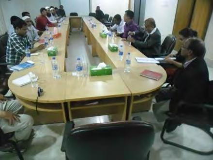
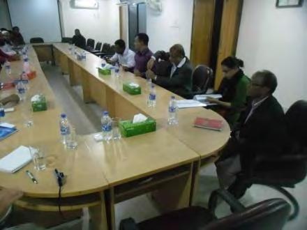
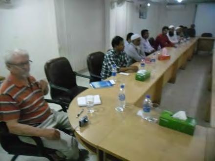
293 Photo: Narayanganj PBS-1 100
294 Appendix 2 Template for Environmental Monitoring Report Environmental Safeguard Monitoring Report Reporting Period Date {From Month, Year to Month, Year} {Month, Year} Title of the Project {Example: SRI: Green Power Development and Energy Efficiency Improvement Investment Program} Prepared by the {Executing Agency} for the Asian Development Bank This environmental safeguard monitoring report is a document of the borrower and made publicly available in a orda e ith ADB s Pu li Co u i atio s Poli y a d the Safeguard Poli y State e t 9. The ie s expressed herein do not necessarily represe t those of ADB s Board of Dire tors, Ma age e t, or staff. 101
295 Executive Summary TABLE OF CONTENTS Page Brief status of environmental compliance during the coverage period 1.0 Introduction 1.1 Brief Project Description 1.2 Project Progress Status and Implementation Schedule 2.0 Compliance to National Regulations 2.1 Environmental Conservation Rules Compliance to Environmental Covenants from the ADB Loan Agreement 3.1 Schedule 5 Environment (prepare a matrix to show how compliance was achieved) 4.0 Compliance to Environmental Management Plan (Refer to the EMP of the Project) 5.0 Safeguards Monitoring Results and Unanticipated Impacts (Refer to the Environmental Monitoring Plan and document any exceedance to environmental standards (if any), or any unanticipated impact not included in the EMP and any correction action/measures taken) 6.0 Implementation of Grievance Redress Mechanism and Complaints Received from Stakeholders (Summary of any complaint/grievance and the status of action taken) 7.0 Conclusion and Recommendations 102
296 Initial Environmental Examination Bangladesh: Bangladesh Power System Enhancement and Efficiency Improvement Project (Component 3: Distribution System Upgrade, Rehabilitation, Extension, and Rural Electrification in BREB Service Areas Part 2) (Rajshahi, Rangpur, Khulna, and Barisal Divisions REB) Prepared by Bangladesh Rural Electrification Board (BREB), Government of Bangladesh for the Asian Development Bank
297 CURRENCY EQUIVALENTS (as of 08/06/16) Currency unit Taka (Tk.) Tk1.00 = USD0.013 USD1.00 = BDT This initial environmental examination is a document of the borrower. The views expressed herein do not necessarily represent those of ADB's Board of Directors, Management, or staff, and may be preliminary in nature. Your attention is directed to the terms of use section on ADB s website. In preparing any country program or strategy, financing any project, or by making any designation of or reference to a particular territory or geographic area in this document, the Asian Development Bank does not intend to make any judgments as to the legal or other status of any territory or area. i
298 Abbreviations ADB AEZ BBS BEZ BMD BREB BWDB CEGIS CITES DAE DC DESCO DEPC DG DoE DoF DoL DPP EA EC ECA EIA EMP EQS FAO FD Asian Development Bank Agro-ecological Zone Bangladesh Bureau of Statistics Bio-ecological Zone Bangladesh Meteorological Department Bangladesh Rural Electrification Board Bangladesh Water Development Board Center for Environmental and Geographic Information Services Convention on International Trade in endangered species Department of Agricultural Extension Deputy Commissioner Dhaka Electricity Supply Company Limited Department of Environmental Pollution Control Director General Department of Environment Department of Fisheries Department of Livestock Development Project Proposal Executing Agency Electrical Conductivity Environment Conservation Act Environmental Impact Assessment Environmental Management Plan Environment Quality Standards Food and Agriculture Organization Forest Department i
299 FGD FIDC FRSS GIS GoB GRM HES HHs IEE IUCN JICA MDG MoEF MoU NCS NEMAP NGO NOC OMS PAPs PBS PCM PD PMU PGCB PPE PWD RP RoW SCADA Focused Group Discussion Forest Industries Development Corporation Fisheries Resources Survey System Geographic Information System Government of Bangladesh Grievance Redress Mechanism Health Environment and Safety Households Initial Environmental Examination International Union for Conservation for Nature Japan International Cooperation Agency Millennium Development Goal Ministry of Environment and Forest Memorandum of Understanding National Conservation Strategy National Environment Management Action Plan Non-Governmental Organization No Objection Certificate Operation Management System Project Affected People (s) Palli Biddyut Samities People s Consultation Meeting Project Director Project Management Unit Power Grid Company of Bangladesh Ltd. Personal Protection Equipment Public Works Department Resettlement Plan Right of Way Supervisory Control and Data Acquisition ii
300 SPS SPC SRDI ToR TSP UNCED UNDP WB Safeguard Policy Statement Spun Pre-stressed Concrete Soil Resources Development Institute Terms of Reference Triple Super Phosphate United Nations Conference on Environment and Development United Nations Development Plan World Bank Weights and Measures o C - degree Celsius ft - foot ft 2 - square feet db(a) - decibel acoustic ha - hectare km - kilometer km/h - kilometer per hour kg - kilogram kv - kilo Volt KVA - 1,000 Volt Amperes m - meter m 3 - cubic meter m 3 /hr - cubic meters per hour mg/l - milligrams per liter mm - milimeter m/s - meters per second MT - metric ton MW - megawatt ppm - parts per million km 2 - square kilometer rpm - revolutions per minute iii
301 μg/m 3 - microgram per cubic meter Glossary Adverse Impact: An impact that is considered undesirable. Ambient Air: Surrounding air. Aquatic: Growing or living in or near water. Bangla: Bengali language. Baseline (or existing) Conditions: The baseline essentially comprises the factual understanding and interpretation of existing environmental, social and health conditions of where the business activity is proposed. Understanding the baseline shall also include those trends present within it, and especially how changes could occur regardless of the presence of the Project, i.e. the No-development Option. Bazar: Market. Beel: A back swamp or depression can be either perennial or seasonal. Beneficial Impacts: Impacts, which are considered to be desirable and useful. Biological Diversity: The variety of life forms, the different plants, animals and microorganisms, genes they contain and the ecosystems they form. It is usually considered at three levels: genetic diversity, species diversity and ecological diversity. Ecosystem: A dynamic complex of plant, animal, fungal and microorganism communities and associated non-living environment interacting as an ecological unit. Emission: The total amount of solid, liquid or gaseous pollutant emitted into the atmosphere from a given source within a given time, as indicated, for e.g., in grams per cubic meter of gas or by a relative measure, upon discharge from the source. Endangered Species: Species in danger of extinction and whose survival is unlikely if the existing conditions continue to operate. Included among those are species whose numbers have been reduced to a critical level or whose habitats have been so drastically reduced that they are deemed to suffer from immediate danger of extinction. Environment Clearance: approval requirement before a project can proceed under the GoB Environmental Conservation Act 1985 iv
302 Environmental Effects: The measurable changes, in the natural system of productivity and environmental quality, resultingfrom a development activity. Environmental Impact: An estimate or judgment of the significance and value of environmental effects for natural, socio-economic and human receptors. Environment Management Plan (EMP): A plan to undertake an array of follow-up activities which provide for the sound environmental management of a project/ intervention so that adverse environmental impacts are minimized and mitigated; beneficial environmental effects are maximized; and sustainable development is ensured. Environment Monitoring Plan: Provides a delivery mechanism to address the adverse environmental impacts of a project during its execution, to enhance project benefits, and to introduce standards of good practice to be adopted for all project works. Environmental Management: Managing the productive use of natural resources without reducing their productivity and quality. Erosion: Process in which wind and water removes materials from their original place; for instance, soil washed away from an agricultural field. Evaluation: The process of looking back at what has been really done or accomplished. Fauna: A collective term denoting the animals occurring in a particular region or period. Flora: All of the plants found in a given area. Habitat: The natural home or environment for a plant or animal. Household: A household is identified as a dwelling unit where one or more persons live and eat together with common cooking arrangement. Persons living in the same dwelling unit having separate cooking arrangements constitute separate households. Land Use: Types include agriculture, horticulture, settlement, pisciculture and industries. Mauza: A Bangla word for the smallest government administrative area corresponding to village revenue unit. Mitigation: An action, which may prevent or minimize adverse impacts and enhance beneficial impacts. Negative Impact: Negative change from the existing situation due to the Project. Project: Distribution System Rehabilitation, Augmentation and Rural Electrification in BREB Service Areas project. v
303 Public Involvement / Public Consultation: A range of techniques that can be used to inform, consult or interact with stakeholders affected / to be affected by a proposal. Reversible Impact: An environmental impact that recovers either through natural process or with human assistance (e.g. cutting off fish migration by an embankment might be reversible at a later stage if a proper regulator is built). Stakeholders: Those who may be potentially affected by a proposal, e.g. local people, the proponent, government agencies, NGOs, donors and others, all parties who may be affected by the Project or to take an interest in it. Taka: Unit of Bangladeshi currency. Terrestrial: Living on land. Thana: Sub-district level of government administration, comprising several unions under district. Union: Smallest unit of local self-government comprising several villages. Upazila: Sub-district name. Upozila introduced in Zila: Bengali word for district. NOTE In this report, "USD" refers to US dollars. vi
304 Table of Contents Abbreviations... i Weights and Measures... iii Glossary... iv Table of Contents... vii List of Tables... xi List of Figures... xi List of Maps... xii List of Photographs... xii Executive Summary... xiii Chapter 1 Introduction and Methodology Background of the Study Objectives of the Project Scope of Work Objectives of the IEE Study Project Area Methodology Structure of the Report Chapter 2 Policy and Legislations Overview Organisations Related with Enforcement of Environmental Standards Ministry of Environment and Forest (MoEF) Department of Environment (DoE) Forest Department Related Other Organizations National Policies and Legislation Relevant to Environment Other Relevant Acts related to Environment The Bangladesh Wildlife Preservation Order (1973; amended to Act in 1974) The National Forest Policy (1994) Policy Related with Energy Development The Electricity Act, 1910 and Electricity Rules The Telegraph Act (1885) The Power Policy, vii
305 2.5.4 The Energy Policy (1996 updated 2004) The Industrial Policy (1999) Compliance with International Requirements Rio Declaration Convention on Biological Diversity, (1992) Wetlands of International Importance as Waterfowl Habitat, (1971) UN Convention on the Law of the Sea, Montego Bay, (1982) Others (Conventions and Agreements) Compliance with ADB Safeguard Policy Statement, ADB s Environment Safeguard Requirements - Policy Principles Compliance with BREB Health Environment and Safety (HES) Requirements Building Construction (Amendment) Act, 1990 & Rules Rules and Policies in Related Fields Chapter 3 Description of the Project Background of the Project Project Category Project Location Material Requirements Proposed Work in the Project Area Construction Works Work Schedule Chapter 4 Environmental and Social Baseline Condition Project Boundary Physical Environment Climate General Rainfall Humidity Sunshine Wind Speed Seismicity Noise Air Quality Water Resources Water Systems and Water Quality Storms Land Resources Agro-ecological zones viii
306 4.6.2 Land Use and Land Type Agriculture Resources Cropping Pattern and Cropping Intensity in the Project Area Ecology Biological Environment Bio-ecological Zoning Ecosystem Diversity Biodiversity Environmentally Sensitive Areas Socio-economic Resources Introduction Administrative Area Population and households Household size Age Structure in the Project Area Literacy Disability Occupations and Livelihoods Housing Condition Sources of Drinking Water Sanitation Facilities Access to Electricity Chapter 5 Prediction of Environmental Impacts Potential Environmental Impacts and Mitigation Measures Water Quality and Water Bodies River Course, Natural Drainage and Irrigation Channels Interference with Roads and Road Crossing Construction Waste Land Use and Encroachment on Land Construction Noise, Dust and Vibration Soil Quality Crop Production Terrestrial Vegetation Wildlife Habitat Loss of Houses, Crops and Human Activities Hazardous Impacts including Hazardous Waste Impacts from Project Workforce Employment Opportunities and Income Generation Industrial and Economic Development Human Safety Impact Screening Chapter 6 Analysis of Alternatives Chapter 7 Information Disclosure, Consultation and Participation ix
307 7.1 Introduction Identification of Stakeholders Approach for Public Consultation Public Consultation Meetings/Focus Group Discussions and PBS Meetings Findings and Issues Raised from Discussions and Meetings: Chapter 8 Grievance Redress Mechanism Grievance Redress Mechanism (GRM) Chapter 9 Environmental Management Plan Mitigation and Remediation Measures Institutional Requirements and Monitoring Plan Budget for the Environmental Management Plan (EMP) Chapter 10 Conclusions APPENDIX 1 VILLAGE MEETINGS AND PBS MEETINGS APPENDIX 2 TEMPLATE FOR ENVIRONMENTAL MONITORING REPORT 96 x
308 List of Tables Table Summary of Project Activities Table Length of Lines in the Project by Voltage and Type Table ADB s Environment Safeguard Requirement Table Environmental Laws, Regulations and Standards of Bangladesh Table Project Activity in PBS and Upazilla Councils Table Proposed Project Work by PBS Locations Table 4.1 -Average Monthly Rainfall Table Number of Normal Rainy Days in the Project Area Table Normal Minimum Temperature Table Normal Maximum Temperature Table Monthly Normal Humidity (%) in the Project Area Table Average Daily Sunshine Hours Table 4.7 Normal Wind Speeds (m/s) Table 4.8 Standard Value (dba) for Noise Table 4.9 Plants Species Growing in the Project Area Table Ecologically Sensitive Areas in the Project Area Table Administrative Areas Inside 35 PBSs Table 4.12 Demographic Characteristics Table 4.13 Household Size Table Population Distributions by Different Age Groups Table Literacy Rates by Each Division in the Project Area Table Distribution of Population by Type of Disability Table Occupation and Livelihood by Division and for Project Area Table Type of Housing Structure in the Project Area Table Sources of Drinking Water Table Access to Sanitation Facilities Table Access to Electricity Table List of Officials Consulted Table Environmental Management Plan Table Monitoring Plan Table Budget for the Environmental Management Plan List of Figures Figure Steps of Initial Environmental Examination (IEE) Figure DoE Environmental Clearance Procedures Figure Monthly Average Rainfall at Rajshahi BMD Station Figure Monthly Average Rainfall at Khepupara BMD Station xi
309 Figure Average Daily Sunshine Hours at Khulna Figure Average Daily Sunshine Hours Rajshahi Figure Average Daily Sunshine Hours at Barisal Figure Type of Housing Structure in the Project Area Figure 4.7- Sources of Drinking Water in Khulna and Rajshahi Divisions Figure Access to Sanitation Facilities in Rangpur and Barisal List of Maps Map Map of The Project PBSs Map Earthquake Prone Area of Bangladesh Map Agro-ecological Zones in Bangladesh Map Land Use Zones of Bangladesh Map Bio-ecological Zones of Bangladesh Map Ecologically Critical and Sensitive Areas of Bangladesh List of Photographs Photo 3.1: Gournadi, Barisal PBS Photo 3.2: Gournadi, Barisal PBS Photo 3.3: Barisal PBS-2 Transformers Photo 3.4: Barisal PBS-2 Pole Mounted Transformers Photo 3.5: Centrifuge Machine Photo 3.6: Spinning Copper Wire Photo 3.7: Oil Change area for Transformers Photo 3.8: Oil Drum Storage on Open Ground Photo 3.9: Rajkor Babaganj Upzilla Photo 3.10: Rajkor Babaganj Upzilla Photo 4.1: Jute Field at Gopalganj District Photo 4.2: Maize Field in Project Area Photo 4.3: Educational Institution in the Project Area Photo 4.4 & 4.5: Housing Condition in the Project Area Photo Typical Sources of Drinking Water xii
310 Executive Summary The Bangladesh Rural Electrification Board (BREB) intends to improve the electricity supply to existing consumers and extend supply to new customers in the rural areas of Bangladesh by implementing a project known as The Distribution System Rehabilitation, Augmentation and Rural Electrification in BREB Service Areas project - 2 (the Project) in Rajshahi, Rangpur, Khulna and Barisal Divisions. According to the Environment Conservation Act 1995 and Environment Conservation Rules 1997 of Bangladesh, distribution projects are categorized as Red Category projects which require Initial Environmental Examination (IEE) for Site Clearance and Environmental Impact Assessment (EIA) for Environmental Clearance. Therefore, in order to obtain Site Clearance and Environmental Clearance from the Department of Environment (DoE), BREB is required to undertake IEE and EIA studies. BREB is in the process of employing consultants to undertake the necessary environmental clearance from DoE. The Project also needs to comply with ADB s Safeguard Policy Statement (SPS) In view of the fact that this is a local electricity distribution project with relatively small scale temporary impacts, based on SPS 2009, the project is category B requiring an IEE. The Project plans to construct 5,500 km of new distribution lines, and 18,000 km of existing distribution lines (operating at 33kV and voltages below) which will be rehabilitated/upgraded/converted in 35 Palli Biddyut Samities (PSBs) covering the western half of the country and construction of new and extension of existing office and accommodation buildings in head office compounds of several PBSs. Another project covering the remaining 42 PSBs in the eastern part of the country has also been prepared by BREB. Asian Development Bank (ADB) is considering lending funds to the GoB for both projects which are designed to assist in both the expansion and upgrading of electricity transmission and distribution systems in the country. The Project will help expand the energy network to rural regions and supply pockets of development in rural areas which are currently without electricity. The new low voltage distribution lines (400 V or 230 V) for the Project involve short extensions of the existing network, each running about one hundred meters. For the 18,000 km of rehabilitate/up-grade/conversion element of the Project, the majority of the work proposed will be undertaken on existing lines operating at 11kV or lower voltages, whilst some work proposed will also be undertaken on lines operating at 33 kv. Construction of new and extension of existing office and residential buildings associated with the Project will be within land owned by several PBSs in their head office compounds. Impacts from the Project will be minor. Work consists of short extensions no more than one hundred meters in extent. For the existing lines old infrastructure will be replaced by new poles, conductors and insulators. Most of the work will be along road sides in existing Rights of Way (RoWs), and there may be disruption of traffic during installation of lines and rehabilitation due to the activity of workers and movement of support vehicles. There may be need to cut back some trees. Construction of new and extension of exiting office and residential buildings do not have environment impact as they are all within office compounds of various PBSs. Project activities do not cross any protected areas or protected forests or sensitive areas and there will be no impacts on terrestrial fauna and flora. There appear to be no issues of displacement of people or impacts on property. Flexibility in location for new locations means that there will be no significant impact from the new lines. The xiii
311 minor impact of noise and any temporary traffic disruption from implementation of the Project are short lived and can be managed. The upgrading and rehabilitation work and the need for ongoing servicing of the network, particularly the thousands of pole mounted transformers, will require PBS authorities to have in place procedures and mechanisms to handle waste materials wood, ceramic insulators, conductor and copper wire on a large scale. Transformers use significant amounts of oil and there is need to replace, recycle and dispose of significant quantities of oil. Procedures will also be in place for the handling and disposal of hazardous waste in the form of replaced timber poles which have been treated with creosote and other preservative chemicals. The Environmental Management Plan (EMP) included in this IEE along with the monitoring plan, will assist project implementation and during ongoing operations at the PBS authorities. A meeting with 25 local people at Rajkor, Barisal Division, indicated that local people are very happy with the Project which will provide them electricity supply. The people also realized improvement in existing supplies and security of supply will give a boost to economic development and the Project was seen as very welcome by the people of Rajkor. A Grievance Redress Mechanism (GRM) will be established at the start of the Project. The GRM will link into the established complaints system already established in the PBS and will handle complaints regarding both Resettlement Plan (RP) and EMP matters. BREB has already set up a Project Management Unit (PMU) to implement existing projects funded by other unilateral and multi-lateral funding agencies, and the PMU will be responsible for the overall implementation of the EMP and the monitoring plan. Costing for environmental mitigation measures will be included in construction contracts. Funds are included (Tk 6 million) for training of BREB staff at headquarters and for training of PBS staff who will be responsible for implementation of the Project and ongoing project monitoring. Tk 30 million is identified for inclusion in BREB recurrent budget for monitoring of the implementation of the IEE. The implementation of this IEE and the associated EMP will meet the need to comply with ADB s SPS xiv
312 Chapter 1 Introduction and Methodology 1.1 Background of the Study 1. In FY2015 1, the Bangladesh power generating system serving the national grid had an installed capacity of 10,939 MW, served a peak demand of 7,817 MW 2, and delivered 43,738 3 GWh to the Power Grid Company of Bangladesh (PGCB) transmission network. Bangladesh Power Development Board (BPDB) as the single buyer, purchases generated electricity from all generating facilities comprising independent power producers, BPDB s subsidiary generating companies, BPDB s own power plants, and from India through the cross border transmission link 4. Electricity is delivered to distribution utilities such as Dhaka Electric Supply Company (DESCO) and Dhaka Power Distribution Company (DPDC) in Dhaka, and to BREB in rural areas for distribution. BPDB too serves as a distribution utility in urban areas of Bangladesh, except Dhaka. 2. Access to electricity was reported to be 72% by mid-june The Government of Bangladesh plans to provide electricity to all households by year The per capita electricity consumption including estimated consumption from captive generation with industries, was 371 kwh 5 in FY2015, which is low compared with other countries in South Asia 6, indicating that power generation, transmission and distribution facilities require significant capacity additions as Bangladesh grows into the middle income status. With the increasing customer base and through the increased demand from customers for household, commercial and industrial activities, the peak demand in Bangladesh is expected to continue increasing in the medium term as Bangladesh transitions to middle income country status. Several major power generation projects and regional cooperation projects are planned to add to generation capacity while PGCB is planning several 400 kv transmission lines to link various parts of the country including Dhaka and Khulna, two major load centres in the country. Potential introduction of 765 kv transmission line is also under consideration. 3. Sales by distribution utilities to end-use customers in FY2015 were 39,600 GWh, indicating that the country s transmission and distribution loss was about 13.02% of generation. The reported distribution loss was 10.82%, which indicates room for improvement. Furthermore, 1 The fiscal year (FY) of the Government ends on 30 June. FY before a calendar year denotes the year in which the fiscal year ends, e.g., FY2014 ends on 30 June Annual Report, Bangladesh Power Development Board (BPDB), FY Energy input to the transmission network. When generation served directly into the networks of Palli Bidyuth Shamiti (PBS) is included, the total generation was 45,836 GWh. 4 A few smaller power plants sell direct to BREB/PBSs. 5 Seventh five-year plan, FY2016-FY2020, Planning Commission, Government of Bangladesh. Electricity sales from the grid was 251 kwh/person in FY2015, as stated in the Annual Report, Bangladesh Power Development Board (BPDB), FY Per capita sales reported in 2015 by other countries in the region (in kwh per year) were Bhutan: 977, India: 760, Maldives: 530, and Sri Lanka:
313 the distribution system requires rehabilitation and upgrades to serve the growing demand in existing service areas and to replace ageing assets. 4. The ADB Bangladesh Power System Enhancement and Efficiency Improvement Project aims to improve electricity transmission and distribution in the country. A summary of the overall project activities is provided in Table 1.1. Project Output and Description Table Summary of Project Activities Length or capacity Additional information Component 1: PGCB s transmission system development in Southern Bangladesh 1.1 Construction of the new 400 kv double circuit transmission line from Aminbazar to Mongla 1.2 Augmentation and upgrade of the exiting 230 kv/132 kv substation at Aminbazar to 400 kv/ 230 kv/132 kv 170 km The line will use quad-finch 7 conductor 3 x 520 MVA Three new 400 kv/230 kv transformers will be installed Component 2: Service improvement in DESCO service areas 2.1 Establishment of a SCADA system in the DESCO service area All 33/11 kv distribution substations will be monitored and remotely controlled Component 3: Distribution system rehabilitation, upgrade, extension and rural electrification in BREB service areas 3.1 Rehabilitation and upgrading of 20,535 km of 33 kv,11 kv and 400 V distribution lines, and expansion of the distribution network by 6,465 km at 42 PBSs in Dhaka, Mymensingh, Chittagong and Sylhet Divisions 3.2 Rehabilitation and upgrading of 18,000 km of 33 kv, 11 kv and 400 V distribution lines, and expansion of the distribution network by 5,500 km at 35 PBSs in Rajshahi, Rangpur, Khulna and Barisal Divisions 27,000 km The expanded distribution network will add 500,000 new customers, with a potential to serve a further 500,000 new customers 23,500 km The expanded distribution network will add 450,000 new customers,, with a potential to serve a further 500,000 new customers 7 Four wires of type Finch bundled together to carry current. 16
314 Project Output and Description Length or capacity Additional information Component 4: Technical assistance for project development, regulatory initiatives, and capacity building 4.1 Feasibility studies and new business models for wind and solar parks 4.2 Transmission planning, project preparatory support for PGCB, and renewable integration studies/protocol development 4.3 GIS-based management system installed in ten PBSs 4.4 Pre-feasibility study on small scale LNG for industries/electricity production 4.5 Implementation of tariff methodology, energy auditing and efficiency improvement procedures for power plants 4.6 Analysis of transmission and distribution losses and establishing regulatory loss targets 4.7 Energy efficiency of buildings: establishment of a building energy efficiency rating system At least four renewable energy parks to be provided with feasibility studies and business models for development Preparation of a 10-year rolling transmission development and investment plan, feasibility and project preparatory studies for grid development, analysis of impacts of grid integration of intermittentresource-based generation and development of protocols Design and implementation of a comprehensive GIS-based network planning and management system for two PBSs (Phase I) and an additional eight PBSs (Phase 2) and operational Pre-feasibility study on the potential demand and delivery mechanisms for small scale LNG for industrial and power generation applications (i) Strengthening of tariff filing and determination process, introduction of regulatory accounting procedures and manual, tariff filing formats (ii) Establishing an energy auditing and efficiency improvement procedure for power plants. Disaggregation of technical and commercial losses in each transmission and distribution entity, and establishing annual loss targets for Part 1: Capacity building and conducting rating assessments Part 2: implementation of solar PV integration to buildings 4.8 Promoting good governance in power sector to provide better service delivery Sector reviews, project design and implementation support, support for sector planning and management 17
315 Project Output and Description 4.9 Capacity building in energy sector planning and management, to provide better service delivery 18 Length or capacity Additional information Capacity building on renewable energy development, grid integration, GIS development, LNG supply development and use 5. Component 3 indicated in Table 1.1 is Distribution system rehabilitation, augmentation and rural electrification in BREB service areas. This component is divided into two subcomponents, in term of the geographic categorization of PBSs. (i) Dhaka, Mymensingh, Chittagong and Sylhet areas, covering 42 PBSs, and (ii) Rajshahi, Rangpur, Khulna and Barisal areas, covering 35 PBSs. Under each subcomponent, the project largely focuses on (a) rehabilitation and upgrading of existing 33 kv, 11 kv and 400 V lines (new customers not directly added but owing to higher line capacity, new customers can be supported in downstream distribution networks), and (b) extension of 400 V or 230 V distribution lines, to serve new customers. Both components have construction of new and extension of existing office and residential buildings within head office compounds of several PBSs. These buildings which have no environmental impacts, and are not considered for detailed study in the IEE. This study relates to the second subcomponent in the 35 PBSs located in Rajshahi, Rangpur, Khulna and Barisal. 6. Distribution lines of PBSs have been built since 1970s, and until 1996, wood poles were exclusively used. These wood poles have a limited life span, typically 20 years. Therefore, a large share of wood poles in service require replacement. Additionally, wooden cross-arms, too, require to be replaced. Owing to the growing demand on existing lines, upgrading the existing electrical conductor to one with a larger cross sectional area, is often required. Furthermore, a second circuit on existing poles is warranted in certain areas to serve the additional demand, without building new lines by opening new line corridors that impact land use. Line extensions too would be required, particularly for 11 kv lines and 400 V lines, to serve customers in interior villages. This project component plans to address the complete range of issues with distribution lines in all PBSs in Bangladesh. The work would involve rehabilitation, strengthening and upgrading of (i) 33kV lines transferring power from PGCB substations to BREB substations, (ii) 11 kv lines serving industrial and household customer areas, (iii) providing new transformers to serve household, small commercial and small industrial customers, and (iv) extension of 400 V lines to serve new customers as well as to improve service quality to existing customers. 7. The Project requires an EIA according to GoB environmental regulations as it ranks as a red project under Department of Environment (DoE) Regulations. BREB is in the process of recruiting consultants (June 2016) to prepare IEE and EIA reports and obtain the necessary project approval from the DoE. 1.2 Objectives of the Project 8. The Project is defined in the Development Project Proposal (DPP) of the Power Division of the Ministry of Power, Energy & Mineral Resources - Up-gradation, Rehabilitation and Intensification of distribution system (Rajshahi, Rangpur, Khulna and Barisal Divisions). The objective of the Project is to improve the quality of electricity supply to existing consumers, to allow capability for consumer growth and to minimize system losses in 35 PBS authorities. This
316 will be achieved with the construction of 5,500 km of new distribution lines and the rehabilitation/up-grading/conversion of 18,000 km of existing distribution lines (maximum 33 kv) as indicated in Table 1.2. Table Length of Lines in the Project by Voltage and Type Existing Lines Rehabilitation/ Upgrade/ Conversion New Line (Short Extension of about Hundred Meters) 33 kv 11 kv 440/ 240 V 11 kv 820 km 12,000 km 5,180 km 5500 km 9. The broad objective is, therefore, to provide more access to electricity, and thereby boost economic development and reduce poverty in the rural areas. The Project aims to connect 450,000 new consumers. This will also result in improving the financial soundness of the concerned PBS with increased income generation from new consumer connections. The Project should contribute to the national economy through added production in the agriculture and industry sectors, with the expansion of industries and business, and by the creation of additional employment. 1.3 Scope of Work 10. The scope of work for the IEE study involves environmental assessment of the activities involved in the extension of the network in the 35 PBS authorities which cover four administrative divisions of Bangladesh (Rajshahi, Rangpur, Khulna and Barisal Divisions). The work involved includes thousands of small sub-projects spread across these four divisions, but the maximum extent at any one location for new works involves only about one hundred meters, at most. 11. The IEE study also provides information on the baseline environmental condition (physical, biological and social environment) of the project area. 12. The IEE identifies environmental and social components likely to be affected by the Project and defines potential impacts. Public consultation was conducted to obtain the perception of locally affected people in area. An Environmental Management Plan (EMP) and Environmental Monitoring Plan and institutional arrangements for future monitoring are developed in the IEE. 1.4 Objectives of the IEE Study 13. According to the Environmental Conservation Act 1995 and Environmental Rules 1997, electricity distribution projects fall under the red category. Red category projects require EIAs to be preceded by IEEs. As this project falls under the red category it is required to obtain Environmental Clearance from the DoE. See Chapter 2 for details of the IEE/EIA process. 19
317 14. Irrespective of GoB regulations, the proposed project falls under Category B according to the ADB guideline with the need for IEE. This document is prepared by e.gen consultants to fulfill ADB requirements ADB s SPS Project Area 15. The location of the PBSs is shown in Map 1.1. The 35 PBSs cover four administrative divisions in the west of the country. The four PBSs cover 68,030 km 2 of the 147,570 km 2 which make up the country. 20

318 Map Map of Bangladesh PBSs 21
319 1.6 Methodology 16. IEE is an initial examination for estimating the potential environmental impacts of a proposed project. IEE is undertaken based on preliminary information available at hand or on information which can be readily obtained through an environmental reconnaissance. The IEE study undertaken for this project specifically follows the steps described below. Figure Steps of Initial Environmental Examination (IEE) i. Analysis of the Project Components 17. All aspects of distribution line construction and rehabilitation works and activities were examined prior to developing a checklist for further analysis. ii. Preparation of Checklist 18. A checklist of potential environmental parameters was prepared based on various guidelines of different agencies such as DoE, World Bank, ADB and Japan International Corporation Agency. The checklist was used to identify potential impacts. iii. Initial Screening and Baseline Survey 19. The list of parameters identified was shortened to focus on significant effects. Also data was collected from all possible secondary sources. Environmental and socio-economic data from different sources (e.g. Bangladesh Bureau of Statistics (BBS), DoE, Bangladesh Meteorological Department (BMD), Bangladesh Water Development Board (BWDB), Agroclimatic survey of Bangladesh and other IEE reports) were collected to prepare the baseline environmental and socio- economic profile of the study area. 22
320 iv. Scaling of Impacts 20. A short description of existing physical, social and environmental conditions of the project sites was prepared and the impacts of project intervention on the physical, environmental and social components were graded in order to identify important components. v. Identification of Enhancement and Mitigating Measures 21. Enhancement and mitigating measures for beneficial and adverse effects respectively were defined. vi. Preparation of IEE Report 22. Finally an IEE report was prepared following standard chapter outlines. 1.7 Structure of the Report 23. The IEE report is structured as follows: Chapter 1: Introduction and Methodology: The introduction chapter presents a brief overview of the assignment along with its background, objectives, scope of work, methodology etc. Chapter 2: Policy and Legislation: Outlines the Policy and Legislation with respect to environmental issues. Chapter 3: Project Description: Describes the proposed project interventions including background, project category, need for the Project, location, size and magnitude of operation. Chapter 4: Description of Environmental and Social Baseline: Presents a description of the environmental baseline condition (socio-economic, physical and biological) of the project area. Chapter 5: Prediction of Environmental Impacts and Mitigation: Deals with the environmental impacts of the proposed project and possible mitigation measures. Chapter 6: Analysis of Alternatives: This section provides brief discussions on alternative options the Project. Chapter 7: Information Disclosure, Consultation and Participation: Mainly describes public opinion of the Project as well as major problems, impacts and any solutions recommended for the Project. Chapter 8: Grievance Redress Mechanism: This chapter set out the mechanisms for resolving complaints about environmental performance. Chapter 9: Environmental Management and Monitoring Plan: Defines the EMP and formulates the monitoring program of the Project and institutional arrangements. Chapter 10: Conclusions: This chapter presents the findings, conclusion, and recommendations of the report. 23
321 Chapter 2 Policy and Legislations 2.1 Overview 24. The implementation and construction of this Project by the BREB requires strict compliance with laws, rules and regulations pertinent to the environment. In Bangladesh the DoE is responsible for ensuring the application of environmental laws and issuance of necessary clearances. 25. The procedures and requirements for EIA under the power sector are dictated by the Environment Conservation Act of 1995, which introduced a requirement for any proposed "industrial unit or project" to obtain prior approval from the DoE. 26. The Environment Conservation Act has classified projects to be assessed (by the DoE) in four categories (green, amber A, amber B, and red). Power sector development projects are allocated to the red category, which triggers an automatic requirement for an IEE followed by a full EIA. Subject to a satisfactory review of the environmental assessment, the DoE issues an authorization for the project to proceed. The authorization consists of two parts: a "site clearance", which gives approval to the site proposed for the project and "Environmental Clearance", which approves the content of the project. 27. The BREB, as project proponent, is responsible for carrying out an EIA study of the proposed project. BREB has the responsibility to administer the environment assessment process through its PMU and consultants, review the findings of consultants, and submit the documents to the DoE for their review. 28. A key requirement of the EIA for projects classified in the amber and red categories is an EMP. The function of the EMP is to enable the project proponent (BREB) to show the DoE how it will deliver the environmental performance assessed in the EIA (for which DoE approval is sought). The EMP must describe in detail organization and management responsibilities, give details of how mitigation measures identified in the EIA will be implemented and explain how monitoring will be carried out. 29. Possession of a "clearance'' from the DoE does not relieve the developer of a project from the requirement to comply with other environmental regulations. In particular, the Bangladesh National Environment Quality Standards (EQS) for industrial effluent have been set and compliance is mandatory. In addition, there are statutory instruments applicable to power sector development projects, which are not primarily environmental in nature, but, which influence environmental impacts. Compliance with such statutory instruments is mandatory Procedure for Obtaining Site/Environmental Clearance Requirement for IEE Reports 30. All industries and projects in the red category must conduct IEEs, which help in understanding the potential extent of environmental changes as a result of the project. The IEE 24
322 finds ways to mitigate negative impacts by considering available information, past experience or standard operating practices. The steps for conducting IEEs are as follows: Collection of baseline information in respect of a project and the environmental setting of the project and its site. Setting of boundaries of an IEE by identifying the significant issues. Impact assessment suggesting mitigation measures, development of an EMP, and discussion of alternative sites for the project or other project modifications. In the event the IEE of the project or industry reveals that further investigation is required to be carried out, the sponsors will have to conduct a detailed EIA Procedure 31. After completion of the IEE Report the project proponent should apply to the DoE in the prescribed format for Site/Environmental Clearance. The application for Environmental Clearance for a project classified in the red category should be accompanied by the following documents: Feasibility study report of the industry/project IEE report An no objection certificate from the local authorities concerned Pollution minimization plan including emergency plan for mitigation of adverse environmental impacts Outline of relocation plans (where applicable) Other information as deemed necessary 32. The Environment Conservation Rules give the Director General of the Department DoE the discretion to issue Environmental Clearance directly without issuing any site clearance to any industry or project if he (the Director General) finds appropriate reason for doing so. 33. As the proposed construction of the Project falls under the "red" category, all necessary requirements mentioned above should be adopted by BREB for the Project Figure 2.1 shows the activities involved in obtaining Environmental Clearance from the DoE. 25
323 Figure DoE Environmental Clearance Procedures APPLICATION TO DoE RED The application should enclose: - Feasibility Study Report (for proposed industry/ project); - Initial Environmental Examination Report and Environmental Impact Assessment Report; - Environmental Management Plan; - An NOC; - Pollution Minimization Plan; - Outline of Relocation Plan, etc. Obtaining Site Clearance Applying for Environmental Clearance Obtaining EnvironmentalClearance Clearance subject to annual renewal NOC Note: = No Objection Certificate, usually obtained from local government. 1. These requirements vary from those of the DoE (1997) in requiring EMPs for proposed, as well as current, projects. 2. Procedure of obtaining Environmental Clearance: for green category projects the gestation period for granting Environmental Clearance has been fixed at within 15 days; for amber A, amber B and red category projects at first Location Clearance and thereafter Environmental Clearance will be granted. The gestation period for Location Clearance is within 30days for amber A, and within 60 days for amber B and red category projects. Source: Adapted from the Environmental Guidelines for Industry (DoE, 1997) 26
324 2.2 Organisations Related with Enforcement of Environmental Standards 36. The roles and responsibilities of various ministries and departments involved in the enforcement of environmental requirements are described below: Ministry of Environment and Forest (MoEF) 37. The Ministry of Environment and Forest (MoEF) is the key government institution in Bangladesh for all matters relating to national environmental policy and regulatory issues. Realizing the ever-increasing importance of environmental issues, the MoEF was created by replacing the Ministry of Agriculture and Forest in 1989 and is at present a permanent member of the Executive Committee of the National Economic Council. This group is the major decisionmaking body for economic policy issues and is also responsible for approving all public investment projects. The MoEF oversees the activities of the following technical/implementing agencies: Department of Environment (DoE) Forest Department (FD) Forest Industries Development Corporation (FIDC) Department of Environment (DoE) 38. In order to expand the scope of environmental management and to strengthen implementation powers, the GoB adopted the Environmental Pollution Control Ordinance in The ordinance provided for the establishment of an Environmental Pollution Control Board, which was assigned with the responsibility of formulating policies and proposing measures for their implementation. In 1982, the Pollution Control Board was renamed as the Department of Environmental Pollution Control. Six divisional offices were established in Dhaka, Chittagong, Khulna, Barisal, Sylhet and Rajshahi. 39. A special presidential order renamed the Department of Environment Pollution Control as the Department of Environment (DoE) and placed it under the newly formed MoEF in The DoE is headed by a Director General (DG). The DG has complete control over the DoE. The power of the DG, as given under the Act, is outlined as follows: The DG has the power to close down activities considered harmful to human life or the environment. The operator has the right to appeal and procedures are in place for this. However, if the incident is considered an emergency, there is no opportunity for appeal. The DG has the power to declare an area affected by pollution as an ecologically critical area. The DoE governs the type of work or process, which can take place in such an area. Before undertaking any new development project, the project proponent must take an Environmental Clearance from the DoE. The procedures to take such clearance are in place. Failure to comply with any part of the Environment Conservation Act (ECA) 1995 may result in punishment by a maximum of 5 years imprisonment or a maximum fine of Tk. 100,000, or both. 27
325 2.2.3 Forest Department 41. This Department under the MOEF is responsible for the protection and management of all reserve forests in the country. Department personnel extend down to the union level in areas where there are reserve forests. The Department has recently started some agro forestry programs and its officers are also responsible for the protection of wildlife in the forests Related Other Organizations 42. There are several other organizations, which have certain social and environmental functions. These organizations include: Ministry of Land: Land Reform and Land Acquisition Directorate Ministry of Water Resources: Bangladesh Water Development Board (BWDB) Ministry of Fisheries and Livestock: Directorate of Fisheries 2.3 National Policies and Legislation Relevant to Environment 43. National Strategies, Policies, Acts and Rules related with the environment include the following: Environment Pollution Control Ordinance, 1977 Environmental Quality Standards for Bangladesh, 1991 National Conservation Strategy (NCS) 1992 Environment Policy (1992) National Environment Management Action Plan (NEMAP) 1995 Environment Conservation Act (1995) Environment Conservation Rules (1997) 2.4 Other Relevant Acts related to Environment The Bangladesh Wildlife Preservation Order (1973; amended to Act in 1974) 44. The Bangladesh Wildlife (Preservation) Order 1973 and amended to Act 1974 provides for the preservation, conservation and management of wildlife in Bangladesh. The earlier legislations on wildlife preservation, namely, the Elephant Preservation Act, 1879, the Wild Bird and Animals Protection Act, 1912, and the Rhinoceros Preservation Act, 1932 have been repealed and their provisions have been suitably incorporated in this law The National Forest Policy (1994) 45. The National Forest Policy of 1994 is the amended and revised version of the National Forest Policy of 1977 in the light of the National Forestry Master Plan. The major target of the policy is to conserve the existing forest areas and bring about 20% of the country's land area under the forestation program and increase the reserve forest land by 10% by the year
326 through coordinated efforts of government organizations, non-government organizations and active participation of the people. 2.5 Policy Related with Energy Development The Electricity Act, 1910 and Electricity Rules This Act amended the laws relating to the supply and use of electricity. Under this act, any person can obtain a license to supply energy and lay down or place electricity supply lines for the conveyance and transmission of electricity. The licensee can open and break up the soil and pavement of any street, railway or tramway and can lay down any line or do other work near other utility services (gas, telecommunication, water, sewer, etc.), provided prior permission is taken from respective authorities, as stated in Section of this Act. 47. According to Section 19 (1) of this act, the licensee shall give full compensation for any damage, detriment or inconvenience caused by him or by anyone employed by him. 48. Sub-section (1) of Section 51 of the Electricity Rules, 1937 advises that a licensee should take precautions in laying down electricity supply lines near or where any metallic substance or line crosses in order to avoid electrocution The Telegraph Act (1885) 49. Under Sections 10-19, Part III (Power to Place Telegraph Lines and Posts), the government can build poles and towers on public land without giving any land compensation The Power Policy, As with the Petroleum Policy, this is presently an integral part of the National Energy Policy It has different policy statements on a whole range of issues including demand forecast, long- term planning and project implementation, investment and lending terms, fuels and technologies, electricity supply to the west zone, isolated and remote load centers, tariff, captive and stand by generation, system loss reduction, load management and conservation, reliability of supply, system stability, load dispatching, institutional issues, private sector participation, human resource development, regional/international cooperation, technology transfer and research program, environment policy and legal issues The Energy Policy (1996 updated 2004) 51. The first National Energy Policy (NEP) of Bangladesh was formulated in 1996 by the Ministry of Power, Energy and Mineral Resources to ensure proper exploration, production, distribution and the rational use of energy resources to meet the growing energy demands of different zones, consuming sectors and consumers groups on a sustainable basis. With rapid change of the global as well as the domestic situation, the policy was updated in The updated policy includes additional objectives namely to ensure environmentally sound sustainable energy development programs causing minimum damage to the environment, to encourage public and private sector participation in the development and management of the energy sector and to bring the entire country under electrification. The policy highlights the importance of protecting the environment by requiring an EIA for any new energy 29
327 development project, or introduction of economically viable and environment friendly technology The Industrial Policy (1999) 52. The National Industrial Policy, 1999 aims to ensure a high rate of investment by the public and private sectors, a strong productive sector, direct foreign investment, development of labor intensive industries, introduction of new appropriate technology, women's participation, development of small and cottage industries, entrepreneurship development, high growth of export, infrastructure development and environmentally sound industrial development. WTO guidelines have been proposed to be followed in the Industrial Policy. 2.6 Compliance with International Requirements 53. Bangladesh has acceded to, ratified or signed a number of major international treaties, conventions and protocols related to environment protection and conservation of natural resources Rio Declaration 54. United Nations Conference on Environment and Development (UNCED) in 1992 adopted the global action Program for sustainable development called 'Rio Declaration' and 'Agenda 21'. Principle 4 of The Rio Declaration, 1992, to which Bangladesh is a signatory along with a total of 178 countries, states, "In order to achieve sustainable development, environmental protection should constitute an integral part of the development process and cannot be considered in isolation from it" Convention on Biological Diversity, (1992) 55. The Convention on Biological Diversity, Rio de Janeiro, 1992 was adopted on 5th June 1992 and entered into force on 29 December Bangladesh ratified the Convention on 20thMarch, This is the overarching framework for bio-diversity and the signatories are required to develop a National Bio-diversity Strategy and Action Plan that incorporates the articles of the Convention into national law and statutes. 56. Obligation has been placed on state parties to provide for environmental impact assessments of projects that are likely to have significant adverse effects on biological diversity Wetlands of International Importance as Waterfowl Habitat, (1971) 57. Convention of wetlands of international importance as waterfowl habitat (1971) is a convention that is also known as the Ramsar Convention. It was adopted on 02 February 1971 and entered into force on 21 December Bangladesh ratified the convention on 20 April This provides a framework for national action and international cooperation for the conservation and wise use of wetlands and their resource. There are 127 parties with 1,085 wetland sites designated as 'Wetlands of International Importance'. 58. This is an intergovernmental treaty, which provides the framework for international cooperation for the conservation of wetland habitats. Obligations for contracting parties include 30
328 the designation of wetlands to the "List of Wetlands of International Importance', the provision of wetland considerations within their national land use planning, and the creation of natural reserves. 59. Bangladesh has two Ramsar sites-parts of the Sundarbans reserved forest (southwest of Bangladesh) and Tanguar Haor (Northeast of Bangladesh). The proposed project will not have any effect on these two Ramsar sites UN Convention on the Law of the Sea, Montego Bay, (1982) 60. This convention was adopted on 10th December, 1982 at Montego Bay, Jamaica and Bangladesh has ratified this convention Others (Conventions and Agreements) 61. The following conventions and agreements include provisions which may be relevant for environmental management, nature protection, and biodiversity conservation: Convention relative to the Preservation of Fauna and Flora in their Natural State 1933; International Convention for the Protection of Birds, Paris, 1950; International Plant Protection Convention, Rome, 1951; The Convention Concerning the Protection of the World Cultural and Natural Heritage, Paris, 1972 has been ratified by 175 states. This defines and conserves the world's heritage by drawing up a list of natural and cultural sites whose outstanding values should be preserved for all humanity. Of the 730 total sites, there are currently 144 natural, 23 mixed and 563 cultural sites that have been inscribed on the World Heritage List (distributed in 125 State parties). These are the 'Jewels in the Crown' of conservation; Convention on International Trade in Endangered Species of Wild Fauna and Flora, Washington, 1973 (Popularly known as CITES): This provides a framework for addressing over harvesting and exploitation patterns which threaten plant and animal species. Under this convention governments agree to prohibit or regulate trade in species which are threatened by unsustainable use patterns; and Convention on the Conservation of Migratory Species of Wild Animals, Bonn, 1979 (Amended 1988): This provides a framework for agreements between countries important to the migration of species that are threatened. 2.7 Compliance with ADB Safeguard Policy Statement, ADB's environmental and social safeguards form the cornerstone of its support to inclusive economic growth and environmental sustainability in Asia and the Pacific. In July 2009, ADB's Board of Directors approved the new Safeguard Policy Statement (SPS) governing the environmental and social safeguards of ADB's operations. The objectives of the SPS are to avoid, or when avoidance is not possible, to minimize and mitigate adverse project impacts on the environment and affected people, and to help borrowers strengthen their safeguard systems and develop the capacity to manage environmental and social risks. 31
329 63. ADB environmental safeguards emphasis development and implementation of a comprehensive EMP. Key elements of EMPs are mitigation measures, monitoring programs, cost estimates, budgets, and institutional arrangements for implementation. In addition, the environmental assessment process emphasizes public consultation, information disclosure, and consideration of alternatives. 64. The key safeguard areas which must be addressed are (i) environmental, (ii) involuntary resettlement, and (iii) indigenous peoples. 65. ADB adopts a set of specific safeguard requirements that borrowers/clients are required to meet in addressing environmental and social impacts and risks. 66. ADB will not finance projects that do not comply with its safeguard policy statement, nor will it finance projects that do not comply with the host country s social and environmental laws and regulations. 67. The safeguard policy statement applies to all ADB-financed and/or ADB- administered sovereign and non-sovereign projects, and their components regardless of the source of financing. 2.8 ADB s Environment Safeguard Requirements - Policy Principles 68. Environmental assessment incorporates the following policy principles: Category A B C F1 Projects are screened and assigned to one of the following categories as soon as possible. Table ADB s Environment Safeguard Requirement Assessment Required A proposed project is classified as category A if it is likely to have significant adverse environmental impacts that are irreversible, diverse, or unprecedented. These impacts may affect an area larger than the sites or facilities subject to physical works. An environmental impact assessment is required. A proposed project is classified as category B if its potential adverse environmental impacts are less adverse than those of category A projects. These impacts are sitespecific, few if any of them are irreversible, and in most cases mitigation measures can be designed more readily than for category A projects. An initial environmental examination is required. A proposed project is classified as category C if it is likely to have minimal or no adverse environmental impacts. No environmental assessment is required although environmental implications need to be reviewed. A proposed project is classified as category F1 if it involves investment of ADB funds to or through a Financial Intermediary. For projects deemed by ADB as highly complex and sensitive, use an independent advisory panel during project preparation and implementation. Conduct an environmental assessment for each proposed project. Assess potential trans-boundary and global impacts, including climate change. Examine alternatives to the project s location, design, technology, and components. 32
330 Avoid/minimize, mitigate, and/or offset adverse impacts. Prepare an environmental management plan (EMP). Carry out meaningful consultation with affected people and facilitate their informed participation. Disclose a draft environmental assessment (including the EMP) in a timely manner, before project appraisal, in an accessible place and in a form and language(s) understandable to affected people and other stakeholders. Disclose the final environmental assessment, and its updates if any, to affected people and other stakeholders. Implement the EMP and monitor its effectiveness. Document and disclose monitoring results. Do not implement project activities in areas of critical habitat, unless (i) there are no measurable adverse impacts on the critical habitat that could impair its ability to function, (ii) there is no reduction in the population of any recognized endangered or critically endangered species, and (iii) any lesser impacts are mitigated. If a project is located within a legally protected area, implement additional programs to promote and enhance the conservation aims of the protected area. Apply pollution prevention and control technologies and practices consistent with international good practices such as the World Bank Group s Environmental, Health and Safety Guidelines. Provide workers with safe and healthy working conditions and prevent accidents, injuries, and disease. Conserve physical cultural resources and avoid destroying or damaging them by using field- based surveys. 2.9 Compliance with BREB Health Environment and Safety (HES) Requirements 69. The BREB has its own policy and requirements for compliance relating to environment, health and safety issues for its operations. The company is committed to managing its operations in a safe, efficient and environmentally responsible manner. The BREB's Health Environment and Safety (HES) manuals, guidelines, procedures and plans are important tools of their commitment. HES manuals include: Environmental Impact Assessment Module, Guideline on Integrated Impact Assessment, Health Impact Assessment Module, and Social Impact Assessment Module. 70. In addition, requirement for impact assessment is affirmed in the BREB's Statement of General Business Principles. The BREB is committed to: Pursuing the goal of no harm to people, Protecting the environment, and Managing HES as any other critical business activity. 33
331 2.10 Building Construction (Amendment) Act, 1990 & Rules The initial Building Construction (Amendment) Act dates back to The earlier Government Buildings Act, 1899, provided for the exemption from the operation of municipal building laws of certain building and lands, which were the property or in the occupation, of the GoB and situated within the limits of a municipality. The provision of municipal building laws to regulate the creation, recreation, construction, alteration or maintenance of buildings within the limits of any municipality was superseded by the 1990 act. The need to regulate the haphazard construction of buildings was addressed by the East Bengal Legislative Assembly and the "Building Construction Act, 1952" was promulgated on 21st March 1953 as the East Bengal Act II of This act was framed to allow streamlining of planned development and implement beautification programs of the government. 72. An important modification to the 1953 Act was added through an Ordinance titled, "the Building Construction (Amendment) Ordinance, 1986 (Ordi. No. LXXII of 1986)". Later in 1987, the ordinance was adopted for enactment as "The Building Construction (Amendment) Act, 1987 (Act No. 12 of 1987)". The preamble of Building Construction (Amendment) Act states that the objectives of the amendment reveals that "although the trial court has the power to order removal of unauthorized construction after passing the order of conviction under section 12, this power has been found to be insufficient, as a criminal case cannot normally be finalized quickly, besides even after completion of the criminal case by the trial court, the is open to appeals". In order to take steps to prevent unauthorized construction or to remove such construction, an authorized officer is empowered through this amendment so that he/she can take necessary action in this respect without intervention of the court. 73. To support the implementation of the provisions laid down in the Building Construction Act, 1952, the GoB made the Building Construction Rules, This was superseded by the Imarat Nirman Bidhimalas, Later in 1996 the Government framed the Imarat Nirman Bidhimala, 1996 (Building Construction Rules, 1996). The Rules are more comprehensive and more relevant to present day circumstances and issues of building construction and other related development activities Rules and Policies in Related Fields 74. In addition to the policies, rules and regulations related to the environment and energy, the following rules and regulations, listed in Table 2.2, are relevant for compliance to maintain sustainable environment. Table Environmental Laws, Regulations and Standards of Bangladesh Year Title Objectives 1885 The Telegraph Act (Act XIII of 1885) Under the law sections 10-19, GoB built transmission line through the country The electricity Act (Act IX of 1910) Under the law section 51, GoB built transmission line through the country East Bengal Protection and Conservation of Fish Act Protection and conservation of fish in Bangladesh The Protection and Conservation of Fish rules Prevention of harming fisheries resource and fisheries habitat in coastal and inland waters. 34
332 Year Title Objectives 1953 Town Improvement Act Improvement and development of Dhaka City Antiquities Act Protection and preservation of archaeological and historical artifacts 1960, Port rules, shipping operation Control of discharges in ports; waterway rules Factories Act Industrial workers' health and working conditions Pesticide Ordinance Pesticide use, production, selection and importation Antiquities (Amendment) Ordinance Protection and prohibition export of archaeological artifacts Municipal ordinance Municipal activities in health, sanitation, water supply, drainage, etc. in the city Factory Rules Disposal of wastes and effluents Agricultural Pesticides (Amendment) Act Selection, use and handling of pesticides in the agricultural sector Municipal Act Drainage, sewerage, water supply and 1982 Acquisition and Requisition of Immovable Property ordinance sanitation. The Acquisition of Immovable Property Rules, 1982 (No. S. R. O U82) The Government adopted these Rules in exercise of the powers conferred upon by Section 46 of The Acquisition and Requisition of Immovable Property Ordinance, 1982 (Ordinance No. II of 1982) Agricultural Pesticides Revised Agricultural Pesticides Ordinance. (Amendment) Ordinance 1985 The Pesticide Rules Pesticide selling, use and safety measures Bangladesh standard Formulation and revision of national standards. specification for drinking water The Penal Code This contains several Articles related with environmental protection and pollution management Building Construction (Amendment) Act and Building Construction Rules The Rules are more comprehensive for taking care of the present day circumstances and issues of building. 35
333 Chapter 3 Description of the Project 3.1 Background of the Project 75. To achieve the objectives of the rural electrification program, BREB established Pally Bidyut Samities (PBS) [which translates as Rural Electric Societies in English]. The PBS idea is based on the model of Rural Electric Co-operatives in USA which is in turn based on the universal principle of co-operative, democratic decentralization and ownership by consumers. The PBS own, operate and manage the rural distribution system within their area of jurisdiction; they are autonomous organization registered with BREB. The influence of the PBS has gradually been expanded and intensified by a series of intensification and expansion projects (ACRE Phase-I to ACRE Phase-V programs). There are now 77 PBSs in Bangladesh which cover most of the country; the Sundarbans and other sensitive areas such as offshore islands and Haor marsh wetland systems are not included in PBS zones. Also, Dhaka city is under Dhaka Electricity Supply Company Limited (DESCO) and Dhaka Power Distribution Company Limited (DPDC) and some other urban areas are supplied by other electricity distribution utilities. 76. BREB is the Executing Agency (EA) for the Project and it will rely on the 35 PBSs in the project area to implement the Project. 77. At present the BREB distribution network consists of 288,189 km of lines operating at voltages 33 kv and below, connecting some million consumers in the 77 PBSs. BREB is the leading electrical energy distributor in Bangladesh with BREB consumers amounting to approximately 50% of national electricity consumption and a rapidly increasing demand. The GoB is committed to expanding the electricity network to every part of the country, while at the same time reducing regional disparity. 78. Currently in the 35 PBSs, there are about 135,210 km of distribution lines, and /11 kv substations to serve about 6.01 million consumers of different categories. Much of distribution network infrastructure has becomes old and in need of replacement and many distribution lines are overloaded. There is need to replace and rehabilitate such items as poles, conductors, insulators and accessories in order to adequately supply existing rural consumers and those households which currently have no electricity supply connection from the national grid. 79. The oldest PBSs such as Barisal 1 and 2 have much outdated infrastructure. Much of the system was installed up to 35 years ago. As well as being old, the demand on these existing lines has increased enormously. 80. Originally all poles were wooden and most have passed their design life and now must be replaced by Spun Pre-stressed Concrete (SPC) poles. About 30% of existing poles are still wooden in many of the PBSs. They are being replaced gradually with SPC poles. 81. Power load on the distribution lines has increased enormously since the first PBS was set up and there is need for more lines, converters and higher sized conductors. Some single phase lines have been upgraded to 3 phase with more pole mounted transformers required. 36
, larger conductors and multiple lines. A 100 kva transformer is full of oil and weighs 450 kg approximately and some poles carry 3 transformers (Phot 3.4). There is need also to increase the height of poles by several meters to achieve required clearances of conductors.")

334 Consequently there is need to provide stronger poles and additional poles along existing alignments to take the additional weight of pole mounted transformers (see Photo 3.3 and 3.4), larger conductors and multiple lines. A 100 kva transformer is full of oil and weighs 450 kg approximately and some poles carry 3 transformers (Phot 3.4). There is need also to increase the height of poles by several meters to achieve required clearances of conductors. 82. Nearly all materials are today sourced locally in Bangladesh when all were imported 10 years ago. Only items such as circuit breakers need to be imported at present. Photo 3.1: Gournadi, Barisal PBS-2 Photo 3.2: Gournadi, Barisal PBS-2 Examples of older wooden poles and wooden cross arms which will be replaced by SPC poles and metal cross arms. Conductors & insulators will also need replacement. Poles carry 33 kv, 11 kv & small voltage conductors. 83. Nearly all new construction work will be awarded through a tender process. For some very short extension lines, a PBS might use their own workers. PBSs have a large established workforce of their own, who are largely housed by the PBS in PBS compounds. PBS staff work on line maintenance and rehabilitation, and particularly for the maintenance of the thousands of pole mounted transforms. 84. Each PBS has its own centralized workshop, warehouse and storage yard facilities. PBSs have established systems to recycle and/or dispose of materials and are bound by PBS Instruction: / Policy for Removal/Sale/Destruction of Obsolete and Condemned (Unusable) Materials of all BREB and PBS Stores 1988 (last revised 2014). World Bank s Environmental Health and Safety Guidelines will be complied with and when the Bangladesh regulations differ from WB s, the borrower will comply with the more stringent standards. Unwanted waste materials are sold at auction every year provided the materials pose no risk of environmental pollution or safety risk. Auctions take place usually in July, the end of the financial year, following taking of a full inventory of materials. 37

335 Photo 3.3: Barisal PBS-2 Transformers Photo 3.4: Barisal PBS-2 Pole Mounted Transformers New and old pole mounted transformers at PBS storage yard. A 100 kva transformer weighs 450 kg and contains 125 kg of oil inside Three Pole mounted transformers supplying different lines 85. Materials unfit for sale due to environmental or safety reasons are landfilled in designated places on PBS owned land or incinerated to ensure that the environment is not polluted and safety is not affected. 86. A committee decides which materials to recycle and which to sell off. The type of materials handled include: 1. Broken insulators plastic and no reuse value sent to landfill, 2. Conductors made of aluminum, copper and steel reinforcement are either reused or auctioned off, 3. Wooden Poles recycled where possible for fencing, as stabiliser for earthing of wires, 4. Wooden cross arms are either reused or the material sold, 5. Unwanted metal sold as scrap, 6. Transformers materials - mainly metal. The iron casings are reused, copper wire is sold off and new copper used for stringing which is done manually for replacement in transformers at the individual PBS centers. 38


336 Photo 3.5: Centrifuge Machine Photo 3.6: Spinning Copper Wire Oil recovery centrifuging machine - Barisal PBS-2 Worker spinning copper wire to be used in repair of pole mounted transformer - Barisal PBS Pole mounted transformers are required to step down the voltage to 230/400 V so that electricity can be supplied to domestic households and commercial consumers. Transformers are maintained by the PBS workforce and a typical PBS will service and recycle approximately 50 transformers per month. Barisal-2 PBS uses 1600 liters of oil per month and has 5,000 transformers in service. A 100 kva pole mounted transformer contains 125 kg oil and even the 5 kva transformer has 20 kg of oil. Barisal-2 stores 20 x 200 liter barrels of oil on site to be able to service pole mounted transformers. Some PBSs have oil recovery centrifuging machines (see Photo 3.5) and oil is recycled for reuse in transformers. Designated approved suppliers are used to undertake recycling. When oil is degraded and no longer usable it is disposed of through these same designated suppliers. Photo 3.7: Oil Change area for Transformers Photo 3.8: Oil Drum Storage on Open Ground Transformer oil is changed and topped up in the PBS yard depot with potential for contamination of soil and groundwater Barisal PBS-2 Yard Oil drums need proper containment in PBS central storage depot to avoid contamination Barisal PBS-2 Yard 39
337 3.2 Project Category 88. Under the criteria of the DoE, GoB, the Project falls under the red category. As per the EIA Guidelines of the DoE, it is mandatory to carry out an IEE for red category projects prior to conducting a more detailed EIA. BREB is currently in the process of engaging consultants to prepare the necessary studies to obtain DoE approval for the Project. 89. For BREB s development partner, ABD, the Project is categorized B for environmental assessment purposes and will require an IEE. This report is prepared in line with ADB Safeguard Policy Statement Project Location 90. The Project is located in four administrative divisions of the country Rajshahi, Rangpur, Khulna and Barisal Divisions. The Project area covers under half the land area of the country, and is in the western side of Bangladesh (see Map 1.1). The population of the four divisions is just over 40% of the population of the country. There will be project activity in all upazila government units in the 35 PBSs. Table Project Activity in PBS and Upazilla Councils Division No of PBS No of Upazila Rajshahi Rangpur 8 58 Kulna 9 63 Barisal 6 45 Total Project Area Material Requirements 91. The main materials specified for the Project as per the (DPP), January 2016 are as follows: 1) Conventional overhead pole-mounted distribution transformers 6.35/0.23 kv 32,130 kva transformers will be procured 2) Porcelain insulators 6.35/0.23 kv, 3) Poles SPC/Wooden/Steel 392,195 poles will be procured 4) Insulated cable 6.35/0.23 kv, 5) Bare uninsulated conductor 69,553 km of conductor will be procured. 92. To implement and support the Project BREB will depute 14 of its existing staff and 93 new personal will be recruited to reinforce staff levels in all 77 PBSs. 3.5 Proposed Work in the Project Area 93. The Table below indicates the extent of work proposed in the Project area giving the length of new lines and lines which will be rehabilitated/upgraded and converted in each of the 35 PBSs. There is only 820 km of 33 kv line included in the Project and this is in the 40
338 rehabilitation/upgrade/conversion category. More than 96% of the lines are at 11 kv or lower voltages. There is 5,500 km of new 11 kv lines in the Project and this will be in hundreds of short extensions of about one hundred meters. Table Proposed Project Work by PBS Locations Sl. No. Name of PBSs Upgrades/ Rehabilitation/ Conversion (km of line) 41 New Lines (Short Extensions of about One Hundred Meters) (km) 33 KV 11 KV 440/ 240 V 11 KV and Below Voltage 1 Rajshahi Nawabgonj Natore Natore Pabna Pabna Sirajgonj Sirajgonj Bogra Joypurhat Naogaon Naogaon Rangpur Rangpur Dinajpur Dinajpur Thakurgaon Nilphamari Kurigram Lalmonirhat 20 Gaibandha Kushtia Meherpur Jessore Jessore Jhenaidah Magura Khulna Satkhira Bagerhat Barisal Barisal Pirojpur Patuakhali Bhola Jhalokhati Total
339 Photo 3.9: Rajkor Babaganj Upzilla Photo 3.10: Rajkor Babaganj Upzilla Examples of semi pucka and kutcha housing to be linked with a new distribution line extension 3.6 Construction Works 94. Construction works are minimal for this project with the infrastructure being installed on existing poles or new poles which require a minimal footprint. A large pole, which is 80 ft, is required to be set 10 ft into the ground according to BREB Standard Specifications. Holes are made and earth is back filled around the pole which for the largest 33 kv pole requires a footprint no more than 4ft 2. Conductors are then strung on new poles and transformers are installed if required along with other fittings. Poles for the small line extension projects will be mostly along existing road RoW or within properties to which power is supplied. 3.7 Work Schedule 161. The completion of works is proposed to take place in 36 months as indicated below in Fig 3.1. Figure 3-1 Project Implementation Schedule 42
340 Chapter 4 Environmental and Social Baseline Condition 4.1 Project Boundary 95. The project area covers 35 PBSs or regions which in turn cover four of the eight administrative divisions which make up Bangladesh. Geographically the PBSs are in the western half of the country. The benefits of the Project will extend to many new customers in these PBSs but with rehabilitation and upgrading of lines, existing customers will also benefit throughout the 35 PBSs with more reliable electricity being available. 4.2 Physical Environment Climate General 96. The project area falls under the influence of the monsoon climate prevailing in the general area. There are three main seasons: Pre-monsoon, summer - March to May, Monsoon, rainy season June to October, and Winter season November to February. 97. The summer is hot and dry interrupted by some heavy rainfall. The monsoon is characterized by hot and humid conditions when a substantial part of the annual rainfall occurs. The winter is predominantly cool and dry. 98. Information on meteorological parameters i.e. rainfall, temperature, relative humidity, wind speed, evaporation and sunshine hours has been collected from the 15 Bureau of Meteorological Department (BMD) Stations which fall inside the four administrative divisions which make up the project area Rainfall 99. Rainfall shows significant variation across the year in the project area and May, June, July, August and September generally show the highest monthly average rainfall. The monthly rainfall figures are provided in Table There is also variation across the geographical area of the Project itself. Chuadanga and Rajshahi inland on the Indian border have only mm and mm respectively and have the lowest total annual rainfall in the project area; Khepupara, meanwhile, on the coast to the east of the Sundarbans experiences the highest rainfall at mm. 43

341 Table 4.1 -Average Monthly Rainfall Rainfall (mm) JAN FEB MAR APR MAY JUN JUL AUG SEP OCT NOV DEC Total Rajshahi ,542.1 Ishurdi ,656.2 Bogra ,843.1 Rangpur ,235.8 Dinajpur ,006.4 Sayedpur ,107.3 Khulna ,809.4 Mongla ,887.6 Satkhira ,742.9 Jessore ,615.0 Chuadanga ,496.5 Barisal ,128.2 Patuakhali ,712.7 Khepupara ,764.1 Bhola ,297.4 Source: BMD Station data 101. Figure 4.1 and Figure 4.2 chart Rajshahi and Khepupara stations showing the difference between the drier summer weather inland at Rajshahi by comparison to Khepupara where approximately twice as much rain falls during the summer monsoon months. Rajshahi has the lowest rainfall of all stations in Bangladesh. Figure Monthly Average Rainfall at Rajshahi BMD Station Source: BMD Station data 44

342 Figure Monthly Average Rainfall at Khepupara BMD Station Source: BMD Station data 102. The number of rainy days experienced in the project area has a similar pattern in the different BMD stations as shown in Table 4.2. From October to April there are few days when rain is recorded and in December no station has more than 1 rainy day. During the period just before the monsoon breaks and during the monsoon itself, rainfall increases and in June, July, August and September about half the days experience rain. Some stations closer to the sea have more than half the month with rainy days. Rajshahi has fewest rainy days and Bhola, a coastal location in Barisal divisions has the most rainy days. Table Number of Normal Rainy Days in the Project Area St_name JAN FEB MAR APR MAY JUN JUL AUG SEP OCT NOV DEC Total Rajshahi Ishurdi Bogra Rangpur Dinajpur Sayedpur Khulna Mongla Satkhira Jessore Chuadanga Barisal Patuakhali Khepupara Bhola


343 Source: BMD Station data Temperature 103. Data for normal temperatures from the BMD stations in the project area are given in 104. Table 4.3 and Table 4.4. Normal minimum and maximum temperatures in the summer and the winter months are fairly consistent across the stations in the project area. Temperatures remain well above freezing point in the coldest months and although summers are warm, extremes of heat are rare. In all station the lowest normal minimum temperatures are experienced in January. The highest normal maximum temperatures are in April and May, premonsoon. Table Normal Minimum Temperature Source: BMD Station data Table Normal Maximum Temperature 46
 in the height of the monsoon rains.")

344 Source: BMD Station data Humidity 105. Humidity across the general project area shows similar variation during the year with highest readings between June and September (see 106. Table 4.5) in the height of the monsoon rains. Humidity is highest at coastal locations in the south of the Project with coastal stations in Barisal Division Barisal, Bhola and Khepupara experience 89% to 90% humidity in July, August and September. The lowest recorded average monthly humidity - 63 % - is in March at inland stations such as Sayedpur and Rajshahi, and these stations have relatively lower humidity in the summer time too. Table Monthly Normal Humidity (%) in the Project Area Source: BMD Station data Sunshine 107. Monthly sunshine hour data are available for various BMD stations and data are presented in Table 4.6 for Kulna, Rajshahi and Barisal Divisions. The monsoon period has comparatively fewer sunshine hours due to increased cloud cover and June, July, August and September show reduced sunshine throughout the project area. See data below in Figure 4.3 to Figure 4.5 for the three divisions of Khulna, Rajshahi and Barisal. Table Average Monthly Sunshine Hours


345 Figure Average Daily Sunshine Hours at Khulna Source: BMD Station data 108. Kulna (see Figure 4.3) has 9 hours sunshine in April and has more than 6 hours sunshine daily for the 8 months October to May. The other rainy months have less than 5 hours with under 4 hours in July. Figure Average Daily Sunshine Hours Rajshahi Source: BMD Station data 48


346 Figure Average Daily Sunshine Hours at Barisal Source: BMD Station data Wind Speed 109. Wind speed data across the project area show significant differences. Wind speed varies from location to location and is also dependent on the time of year. The windiest months of the year tend to be during the pre-monsoon period. Wind speeds stay high during the summer monsoon but gradually decrease until November which is usually the calmest month in the project area. Table 4.7 Normal Wind Speeds (m/s) Source: BMD Station data 49
347 110. Dinajpur, a station in Rangpur division in N.E. Bangladesh experiences the lowest overall monthly average wind speed of all stations in the project area with just 1.32 m/s. The highest and most consistent wind speeds are those stations closest to the coast i.e. Khepupara and Jessore. Figure 4.6 and 111. Source: BMD Station data 112. Figure 4.77 shows the charts for stations of Dinajpur and Kepupara. The two stations exhibit extremes of low and high wind speeds respectively. The charts show a similar pattern of seasonal variation with lowest winds registered in November and December and highest in the monsoon, rainy period and the pre-monsoon period. The strength of winds throughout the year is two or three times stronger in Khepupara than is experienced in Dinajpur. Figure Wind Speed at Dinajpur Source: BMD Station data Figure Wind Speed at Khepupara 50

348 Source: BMD Station data Seismicity 113. Bangladesh has been classified into three seismic zones as indicated in the Map 4.1. The Project falls in Zones 2 and Zone 3. Southern regions of the country experience reduced seismic coefficients and Zones 2 and 3 have 0.05g and 0.04g respectively. Pole foundations for the distribution lines and pole mounted transformers are designed to resist prevailing earthquake forces. 51

349 Map Earthquake Prone Area of Bangladesh 52
350 4.3 Noise 114. The standard values for noise as per Schedule 4 of the Standards for Sound of Bangladesh Conservation Rules 1997 are shown in the following Table. Table 4.8 Standard Value (dba) for Noise Category Zones Standard Value (dba) Day Night A Quiet place (hospitals, education institutions, etc.) B Areas which are used mainly for residential purpose C Areas which are used for residential and commercial purposes D Commercial area E Industry area Source: Environmental Conservation Rules, 1997, DoE 115. Most of the work of the Project will be in residential areas. Some of the upgrading and rehabilitation work is in commercial and industrial areas; the above standard noise levels will apply i.e. for residential Category B during day time (6 a.m - 9 p.m). Prevailing noise levels in urban and rural areas are near or above these standards. 4.4 Air Quality 116. Standard quality of ambient air in different area categories, according to the Bangladesh Environmental Conservation Rules, is provided below. Table Standards of Ambient Air Quality Area Categories Concentration (μg/m 3 ) SPM SO 2 CO 2 NOx A Industry B Commercial C Residential and rural area D Sensitive SPM Suspended Particulate Material Source: Environmental Conservation Rules, DoE Expected level of suspended particulate material in ambient air during erection of distribution poles and transportation of material will be low, as the scale of earth works expected to take place will be relatively small. 4.5 Water Resources Water Systems and Water Quality 118. Several rivers govern the overall hydrology of the project area. There are also many lakes/water bodies in the project area which in many places is very low lying. The Padma, far the largest river in Bangladesh, flows in part through the project area. The Padma River is joined by the Jamuna River (the name for the Brahamaputra in Bangladesh). The Padma- 53
351 Ganges is the central part of a deltaic river system with hundreds of rivers and streams--some 2,100 kilometers in length--flowing into the Padma and eventually discharging into the Bay of Bengal The Project has little or no impact on water systems in the area with infrastructure following existing roads/row and extending the distribution system by means of new poles. There will be no river crossing of distribution lines or impact on water quality In many areas, particularly in regions closer to the coast, there is substantial standing water during the monsoon season. However, the Project mainly serves residential development and settlements that are on higher ground and the distribution lines will mainly extend along existing highway routes raised above potential flood prone areas Storms 121. Seasonal storms, popularly known as nor westers (Kalbaishakhi) occur in the project area. Tornadoes can be associated with severe nor westers. The frequency of nor westers is greatest in April and they most often occur in late afternoons. 4.6 Land Resources Agro-ecological zones 122. There are 30 agro-ecological zones (AEZ) and 88 sub zones which have been identified in Bangladesh. An AEZ is a zone or region with a unique combination of physiographic (land forms and parent materials), soil properties, soil salinity, depth and duration of seasonal flooding and agro-climatology (FAO/UNDP, 1988, BARC, 2012). Fertility status of these regions varies considerably. Individual farmers have fragmented the land into small pieces causing wide variation in the management of each and every piece of land. This leads to the large difference in the fertility levels even between adjacent plots The Project falls in four administrative divisions, namely (i) Rangpur, (ii) Rajshahi, (iii) Khulna, and (iv) Barisal. Rangpur Division 124. In this division, there are four agro-ecological zones. These are (i) Old Himalayan Piedmont Plain; (ii) Active Tista Floodplain; (iii) Tista Meander Floodplain: (iv) Level Barind Tract. Old Himalayan Piedmont Plain (AEZ-1) 125. This a distinctive region, developed in an old Tista alluvial fan extending from the foot of the Himalayas. It has a complex relief pattern. Deep, rapidly permeable sandy loams and sandy clay loams are predominant in this region. They are strongly acidic in topsoil and moderately acidic in subsoils: Low in weatherable potassium minerals. Seven general soil types occur in the region, of which non-calcareous brown floodplain soils, black terai soils, and non-calcareous dark grey floodplain soils predominate. Organic matter content is generally higher than in most Floodplain soils of Bangladesh. The natural fertility of the soil is moderate but well sustained. 54
352 Soil fertility problems include rapid leaching of trace metals. Most of Panchagarh and Thakurgaon districts and the northwestern part of Dinajpur district are included in this zone. Active Tista Floodplain (AEZ-2) 126. This region includes the active floodplains of the Tista, Dharla and Dudhkumar rivers. It has complex patterns of low, generally smooth ridges, inter-ridge depressions, river channels and cut-off channels. The area has irregular patterns of grey stratified sands and silts. They are moderately acidic throughout. Four general soil types occur in the region, and of them, noncalcareous alluvium predominates. Organic matter contents and soil fertility levels are low to medium. Tista Meaner Floodplain (AEZ-3) 127. This region occupies the major part of the Tista floodplain as well as the floodplain of the Atrai, Little Jamuna, Karatoya, Dharla and Dudhkumar rivers. Most areas have broad floodplain ridges and almost level basins. There is an overall pattern of olive brown, rapidly permeable, loamy soils on the floodplain ridges, and grey or dark grey, slowly permeable, heavy silt loam or silty clay loam soils on the lower land. Eight general soil types occur in the region; they are moderately acidic throughout, low in organic matter content on the higher land, but moderate in the lower parts. Fertility level is low to medium. Soils, in general, have good moisture holding capacity. North Eastern Barind Tract (AEZ-27) 128. This Zone occupies several discontinuous areas in the south of the Rajpur Division. It has silty or loamy topsoil and clay loams to clay subsoil. The soils are strongly acidic in reaction. Organic matter in the soils is low. General fertility is poor. Rajshahi Division 129. In this division, there are four agro-ecological zones. These are (i) Tista Meander Floodplain: (ii) Karatoya-Bangali Floodplain, (iii) Lower Atrai Basin, (iv) Lower Purnarbhaba Floodplain, (v) Lower Ganges Floodplain, (vii) Level Barand Tract, (viii) High Barind Tract. Tista Meaner Floodplain (AEZ-3) 130. This is the same zone as described in Ranjpur division above. Karatoya-Bangali Floodplain (AEZ-4) 131. This region is very similar to the Tista Meander Floodplain in physiography and soil, and comprises a mixture of Tista and Brahmaputra sediments. Most areas have smooth, broad, floodplain ridges and almost level basins. The soils are grey silt loams and silty clay loams on ridges and grey or dark grey clays in basins. Five general soil types occur in the region, of which non-calcareous grey floodplain and non-calcareous dark grey floodplain soils predominate. The soil is moderately acidic throughout. Organic matter contents are generally low in the cultivated layer of ridge soils and moderate in basins. General fertility is medium. The eastern half of Bogra and most of Sirajganj Districts are included in this zone. Lower Atrai Basin (AEZ-5) 132. This region comprises the low lying area between the Baring Tract and the Ganges river floodplain. It includes the Chalan Beet area. Dark grey, heavy, acidic clays predominate in this 55
353 smooth low-lying basin land. Seven general soil types occur in the region. Organic matter, and status of other essential nutrients are medium, while the level of available potassium is high. Fertility status of soils is moderate. Lower Purnarbhaba Floodplain (AEZ-6) 133. This small region of only 129 km 2 occupies basins and beels separated by low floodplain ridges. In this area, dark grey, mottled red, very strongly acid, heavy clays occupy both ridge and basin sites. Organic matter status is medium to high. General fertility level is medium with high potassium bearing minerals. The western part of Naogaon and the northern part of Nawabganj districts are included in this AEZ. Lower Ganges River Floodplain (AEZ-12) 134. This region comprises the north-eastern, eastern and south-eastern parts of the Ganges Meander Floodplain which are lower lying than the western part. The ridges are mainly shallowly flooded, but basins become moderately deep or deeply flooded in the rainy season. The soils of the Low Ganges River Floodplains are silt loams and silty clay loams on the ridges and silty clay loams to heavy clays on lower sites. General soil types predominately include calcareous dark grey, grey and calcareous brown floodplain soils. Organic matter content is low in ridges and moderate in the basins. Soils are calcareous in nature having neutral to slightly alkaline in reaction. General fertility level is medium. High Barind Tract (AEZ- 26) 135. This is a very small zone of 16 km 2 ; it includes the southwestern part of the Barind Tract where the underlying Madhupur Clay had been uplifted and cut into by deep valleys. The soils include puddled silt loam to silty clay loam in the topsoils and porous silt with mottled plastic clay at varying depth. Deep grey terrace soils and grey valley soils are major components of the general soil types of the area. General fertility status is low, having low status of organic matter. 56
354 Map Agro-ecological Zones in Bangladesh 57
355 Kulna Division 136. The Khulna division comprises three agro-ecological zone and all are floodplain zones; they are as follows: High Ganges River Floodplain (AEZ-11) 137. This zone includes the western part of the Ganges river floodplain which is predominantly highland and medium highland. Most areas have a complex relief of broad and narrow ridges and inter-ridge depressions. The upper parts of high ridges stand above normal flood level. Lower parts of ridges and basin margins are seasonally shallowly flooded. General soil types predominantly include calcareous dark grey floodplain soils and calcareous brown floodplain soils. Organic matter content in the brown ridge soils is low but higher in the dark grey soils. Soils are slightly alkaline in reaction. General fertility level is low. Lower Ganges River Floodplain (AEZ-12) 138. The characteristics of this zone are described in the Rajshahi division above. Ganges Tidal Floodplain (AEZ-13) 139. This zone occupies an extensive area of tidal floodplain land in the southwest of the country including the Sundarbans which do not fall in the project area. The greater part of this region has smooth relief having large areas of salinity. Riverbanks generally stand about a metre or less above the level of adjoining basins. Non-calcareous grey floodplain soil is the major component of general soil types. Acid suphate soil also occupies a significant part of the area, where it is extremely acidic during the dry season. Most of the topsoils are acidic and subsoils are neutral to mildly alkaline. General fertility level is high, with medium to high organic matter content. Barisal Division 140. There are only two agro-ecological zones in this division comprising tidal and estuarine floodplain zones: (i) Ganges Tidal River Floodplain and (ii) Young Meghna Estuarine Floodplain. Ganges Tidal Floodplain (AEZ-13) 141. The characteristics of this zone are described in the Khulna division above. Young Meghna Estuarine Floodplain Ganges (AEZ-18) 142. This zone occupies young alluvial land in and adjoining the Meghna estuary. The major soil types are grey to olive, deep calcareous silt loam and silty clay loams, and are stratified either throughout or at shallow depth. Calcareous alluvium and non-calcareous grey floodplain soils are the dominant general soil types. Topsoils and subsoils of the area are mildly alkaline. General fertility is medium but low in nitrogen and organic matter Land Use and Land Type 143. Land use in the project area and much of Bangladesh is dominated by human activity. According to the World Bank, only 11.1% of Bangladesh has forest cover but only 30.2% is primary forest and a great majority of this in the Sundarban mangrove forests in the south west and in the Chittagong Hill Tract regions in the east (see Land Use Map 4.3). Neither of these 58
356 areas is included in the Project. Much of the land particularly in the south and central area of the Project in Kulna and Barisal is low lying and subject to flooding in the monsoon season. The land, although low lying is used intensively for agriculture. The basic land use map for Bangladesh is depicted in Map 4.3. Map Land Use Zones of Bangladesh 59

357 4.7 Agriculture Resources Cropping Pattern and Cropping Intensity in the Project Area 144. Most agricultural land in the project area tends to be intensively used with double or triple cropping pattern being common with rice as the main crop. Jute, maize, wheat, potatoes and various vegetables are also grown depending on season and location. Photo 4.1: Jute Field at Gopalganj District Photo 4.2: Maize Field in Project Area 4.8 Ecology Biological Environment 145. The project area falls in various terrestrial and aquatic ecosystems consisting of mainly floodplain lands, peat lands and river terrain. With a variation of land forms the area once supported a natural abundance of wildlife and vegetation. The project area today is much changed with homesteads and intensive agriculture, but many rivers, beels, ponds, ditches and floodplain still support various species of flora and fauna Bio-ecological Zoning 146. IUCN-The World Conservation Union has identified 25 bio-ecological zones (2002) based on physiography, climate, soil type, flooding depth and biodiversity. The Project falls within seven of these defined bio-ecological zones, i.e. Himalayan Piedmont Plain, Barind Tract, Teesta and Ganges Floodplains, Chalan Beel, Gopalganj/Khulna peat lands and the Saline Tidal Floodplain and Major rivers. See Map Ecosystem Diversity 147. The land in the project area predominantly comprises paddy land/floodplains followed by homesteads, terraces, canals in order of significance. Overall ecosystems in the project area can be divided into following categories: 60
358 148. Crop fields: This land is usually used for paddy cultivation once/twice/the times in a year and inundated during the monsoon period. In these areas there is least diversity of floral communities but numerous indigenous fishes and birds find feeding habitat Settlements/homesteads: This ecosystem comprises economic tall plants e.g. jute, maize with undergrowth of wild flora. Homesteads are constructed at comparatively high elevation and settlement/homestead land exhibits mainly terrestrial ecology. Homestead platforms and higher agricultural land is also used for commercial plantations with fruit and timber yielding trees for furniture making and also to meet domestic fuel wood needs Canals and rivers: Canals and rivers are the main source of water in the project area for all ecological components both terrestrial and aquatic. The main rivers are perennial sources of water. Numerous canals also exist and these support scattered hydrophytes in the areas which retain water for at least a part of the year Ponds and ditches: These are largely closed water wetland area and are controlled to meet human needs for domestic use and for irrigation purposes. Water levels fluctuate widely with the seasons; various smaller water dependent animals are supported in this environment Roadside vegetation: Consisting of fast growing flora which is planted to protect embankments and roads from soil degradation and erosion. The lower land is occupied by marginal vegetation, while along the road side species indicated in Table 4.10 tend to be planted Mangrove ecosystem: This system is found in areas of the country with tidal flows and many mangroves species are found mainly in south west Bangladesh outside the project area. The ecotone or transition zone between two ecosystems (tidal and freshwater) had abundant mangrove vegetation. This is now much changed with river levees and canal banks inhibiting the tidal flow to develop fish culture. The main area of mangrove forest the Sundarbans reserve adjoins the project area. The project will not have impacts on the mangrove forest Biodiversity Flora 154. Terrestrial Flora: The project area contains a diversity of species in the different ecosystems described above. In and around homesteads species are planted according to their potential for human use and consumption for timber, fuel and fruit purposes. Trees that are to be found are Gagon Sirish (Albizia richardiana), Rendi Sirish (Albizia saman), Sada Koroi (Albizia procera), Mahagoni (Swietenia mahogoni), Eucalyptus (Eucalyptus sp). For fruit demand (coconuts, banana, dates, mango etc) the following species are grown Narikel (Cocos nucifera), Taal (Borassus flabellifer), Kola (Musa sp.), Khejur (Phoenix sylvestris), and Aam (Mangifera indica) mainly around homesteads. Bamboo is grown widely. Commercial planted crops are to be found in homesteads, along village roads and directly in crop land and the following three species predominate - Akashmoni (Acacia moniliformis), Mahagoni (Swietenia mahagoni) and Taal (Borassus flabellifer) or the Asian sugar palm. Table 4.17 indicates the major plant species and their use. 61

359 Map Bio-ecological Zones of Bangladesh 62
360 Table 4.9 Plants Species Growing in the Project Area Tree Species Family Usage Narikel (Cocos nucifera) Palmae Fruit and fuel wood Aam (Mangifera indica) Anacardiaceae Fruit and timber Akashmoni (Acacia sp.) Mimosaceae Timber and fuel wood Bansh (Bamboosa sp) Poaceae Thatching Mahagoni (Swietenia mahagoni) Meliaceae Timber and medicine Sirish (Albizia lebbeck) Leguminosae Timber and fuel wood Chambul (Albizia richardiana) Leguminosae Timber Eucalyptus (Eucalyptus sp) Leguminosae Timber and fuel wood Rendi Sirish (Albizia saman) Leguminosae Timber and fuel wood Taal (Borassus flabellifer) Palmae Fruit and timber Khajur (Phoenix dactylifera) Arecaceae Fruit and fuel wood Katbel (Limonia acidissima) Rutaceae Fruit and timber Supari (Areca catechu) Palmae Timber and fuel wood Tatul (Tamarindus indica) Leguminosae Fruit Silkoroi (Albizia procera) Leguminosae Timber and fuel wood Sisso (Dalbergia sissoo) Fabaceae Timber and fuel wood Gewa (Exocearia agallocha) Euphorbiaceae Timber and fuel wood Kawra (Sonneratia apetala) Sonneratiaceae Fruit and fuel wood Kanthal(Artocarpus Moraceae Fruit and timber heterophyllus) Kadom(Anthocephalus chinensis) Rubiaceae Timber and fuel wood Desi Gaeb (Diospyros peregrina) Ebenaceae Fruit Note: H = High M = Medium L = Low Average Height (Meter) Density H H H H H H H M M M 9-12 M 5-7 L 8-10 M L M M 7-10 L 6-8 L 5-8 M L 3-5 L 155. While cultivated species predominate in the landscape, there are a variety of other species of flora, both native and non-native, to be found on agricultural lands such as Digiteria spp (wild grass), Eclipta alba (false daisy a herb), Echinochola colonum (jungle rice), Hemarthrira sp (herbaceous grass), Polygonum spp (knotweed family), Rumex aciculate 63
361 (buckwheat family), Alternanthera sessilis (aquatic plant), Dentella repense (creeping plant), Cynodon dactylon (couch grass), and Cyperus spp (sedges) Aquatic Flora: There is a great floral diversity of aquatic plant life in the river, canals and seasonal floodplains and ditches inside agricultural lands. Among the free floating species, kochuripana (Eicchornia crassipes) is mostly found inside rivers and canals. Shapla (Nymphaea spp.) and chandmala (Nymphoides sp) grown in floodplains during the monsoon period and comprise the common rooted floating plant. Also the species Hydrilla versillata, and Hygrorhiza aristata are present along with the rarer Enhydra fluctuans and ludwigia species. Fauna 157. Terrestrial Fauna: Mammals species are few in number or have disappeared completely from much of the area, which exhibits lack of natural forest cover and changed habitat with loss of native plant species. Small mammals are present in forest patch habitats and open grasslands in some locations such as fishing cat (Falis viverrina), jungle cat (Falis chaus), bengal fox (Vulp bengalensis), common mongoose (Herpestes edwardsi) and some bats. Common lizards within the project area include the common skink (Mabuya carinata) and the garden lizard (Calotes versicolor). Populations of grey monitor (Varanus bengalensis) are healthy. Some snakes such as checkered keelback (Xenochrophis piscator) and the smooth water snake (Enhydris enhydris) are present in wetland areas Many birds found in the area are reliant on habitat in crop fields, settlement vegetation and the floodplain areas. Mynas, pied starling, sparrow, bulbuls, cuckoo, crows, herons, egrets and babui are common, and various species of raptors such as kites, buzzards and eagles are found in the open area of crop fields and floodplains Aquatic Fauna: There are many fish species present, and seasonal floodplain and water bodies support wide breeding and feeding habitat for indigenous fish. Common amphibian species occurring in the area are common toad, skipper frog, cricket frog and Indian bull frog. Turtles are quite rare, but spotted flapshell (Lissemyspunctate) and Indian roofed turtles (pagashura tecta) do occur in undisturbed ditches and ponds. Water dependent bird species are found along the many rivers, floodplains, ditches e.g. little cormorant, Indian pond heron, common kingfisher, stilts etc Environmentally Sensitive Areas 160. The Bangladesh Environment Conservation Act 1995 (ECA 95) includes provision for Ecologically Sensitive Area (ESA) declarations by the Director General of the DoE in certain cases where the ecosystem is considered to be in danger of reaching a critical state. The following areas have been declared as sensitive areas under the Act. Table Ecologically Sensitive Areas in the Project Area Sl. No. Name Districts Area (ha) 1 The Sundarbans Begerhat, Khulna, Satkhira 762,034 2 Cox's Bazar (Teknaf, Sea Cox's Bazar 10,465 beach) 3 St. Martin Island Cox's Bazar Sonadia Island Cox's Bazar 4,916 5 Hakaluki Haor Maulavi Bazar 18,383 64
362 Sl. No. Name Districts Area (ha) 6 Tanguar Haor Sunamganj 9,727 7 Marjat Baor Jhinaidha Gulshan-Banani-Baridhara Lake Dhaka n.a Source: DoE 161. Hakulaki Haor and Tanguar Haor are both marsh wetland systems in Sylhet Division in the northeast. The Chittagong Hills which has two wildlife sanctuaries and the Kaptai National Park is also not included in the project area. The Sundarbans Delta is situated on the border of India and Bangladesh, where the Ganges, Brahmaputra, and Mehgna rivers converge in the Bengal basin. The Sundarbans constitute the largest mangrove forest in the world, and it is in Kulna Division, but is outside the PBS network. None of these declared sensitive areas are in the project area or are affected by the Project. Map Ecologically Critical and Sensitive Areas of Bangladesh 65
363 4.9 Socio-economic Resources Introduction 162. Information on the baseline condition of social and economic resources of the project area is provided below. A number of socio-economic indicators are analyzed based on data available from the 2011 census for the four divisions in which the Project falls Administrative Area 163. The Project consists of hundreds of small subprojects within four administrative divisions of Bangladesh Barisal, Khulna, Rajshahi and Rangpur. Within the four divisions there are 31 districts, 227 upazilas and 1,970 union parishads as presented in the Table below. According to the DPP for the Project, there will be project activity in all upazilas. Table Administrative Areas Inside 35 PBSs Division District Upazila Union Barguna 5 42 Barisal Barisal Bhola 7 68 Jhalkathi 4 32 Patuakhali 7 71 Perojpur 7 51 Subtotal Bagerhat 9 75 Chuadanga 4 32 Jenidah 6 67 Jessore 8 91 Khulna Khulna Kustia 6 66 Magura 4 36 Meherpur 3 18 Narail 3 38 Satkhira 7 79 Subtotal Bogra Chapai Nawabganj 5 45 Joypurhat 5 32 Rajshahi Naogaon Natore 6 52 Pabna 9 73 Rajshahi Sirajganj 9 82 Subtotal Dinajpur Rangpur Gaibanda 7 82 Kurigram
364 Division District Upazila Union Lalmonirhat 5 45 Nilpamari 6 61 Panchaghar 5 43 Rangpur 8 83 Subtotal Total Source: Population Census, BBS, Population and households 164. The 35 PBSs cover less than half the land area of Bangladesh. In terms of population, the 35 PBSs represent more 40% of the total population of the country. The female to male ratio is close to 1 in all divisions. Population densities in Bangladesh are relatively high throughout the country. Barisal Division has the lowest density of the divisions in the project area and Rajshahi Division has the highest with more than 1,000 per km 2. Table 4.12 Demographic Characteristics Divisions Household Population Male Female Sex Ratio (F/M) Area (km 2 ) Persons/ km 2 Barisal 1,862,841 8,325,666 4,089,508 4,236, , Khulna 3,739,779 15,687,759 7,842,533 7,845, Rajshahi 4,486,829 18,484,858 9,256,910 9,227, , , Rangpur 3,496,878 14,397,716 7,180,543 7,217, , Total 13,586,327 56,895,999 28,369,999 28,526, , Project Bangladesh 32,173, ,043,697 72,109,796 71,933, , Source: Population Census, BBS, Household size 165. The 2011 Census shows that 65% of households (HH) in the Project area comprise four or more family members as depicted in Table 4.13 Household Size The average household size in the project area is 4.0 members which is lower than the national average of 4.44 members. Divisions No of HHs (Million) Table 4.13 Household Size No of Persons in Household and Percentage in Each Group Barisal % 10.08% 18.17% 24.22% 20.02% 12.03% 6.15% 6.07% 4.08 Khulna % 11.04% 22.19% 28.25% 18.27% 9.09% 4.12% 4.12% 3.60 Rajshahi % 11.90% 23.45% 28.06% 17.00% 8.21% 3.79% 4.17% 4.09 Rangpur % 11.79% 21.45% 27.14% 18.49% 9.14% 4.00% 3.68% 4.10 Total /Avg Project % 11.20% 21.31% 26.91% 18.44% 9.61% 4.51% 4.51% 3.96 Source: Population Census, BBS, Ave. HHs size


365 4.9.5 Age Structure in the Project Area 167. Analysis of age structure shows that just over 33 % of total population in the four divisions are children (ages up to 14 years), 59% are of working age i.e. between 15 to 59 years, which is considered as the active workforce. Table Population Distributions by Different Age Groups Division Percentage of Population in Each Age Group Barisal 10.4% 13.3% 12.7% 8.4% 7.8% 8.3% 23.3% 6.8% 3.3% 5.7% Khulna 8.8% 11.2% 11.2% 8.6% 8.9% 9.4% 26.6% 7.0% 2.9% 5.4% Rajshahi 9.6% 11.6% 10.7% 8.4% 9.2% 9.8% 26.4% 6.8% 2.8% 4.8% Rangpur 10.6% 12.9% 11.2% 8.0% 8.5% 9.3% 25.1% 6.8% 2.8% 4.8% Project 9.7% 12.1% 11.3% 8.3% 8.8% 9.3% 25.7% 6.8% 2.9% 5.1% Source: Population Census, BBS, Literacy 168. The literacy rate for the population 7 years and above in the project area is 50.5 % which is lower than the national literacy rate of 51.7 %. Similarly, male and female literacy rates in the project area are lower than that of the country as a whole. Barisal shows the highest literacy rates at % for males and % for women, while Ranjpur has the lowest rates at % and % respectively. Female literacy rates consistently trail those of men but by only a few percentage points. Photo 4.3: An Educational Institution in the Project Area Rakudia Govt Primary School, Babuganj Upazilla, Barishal receives students up to grade 6. The school has 260 students (115 girls) and 9 teachers, and has no electricity connection. Needs only a one pole extension to link it to the electricity distribution system. 68
366 Table Literacy Rates by Each Division in the Project Area Division Total Literacy Male Literacy Female Literacy Total Population % of Total Literate Total Male Population % of Males Literate Total Female Population % of Females Literate Barisal 7,022, ,429, ,593, Khulna 13,595, ,776, ,819, Rajshahi 15,838, ,906, ,931, Rangpur 11,514, ,712, ,802, Project 47,971, ,824, ,146, Source: Population Census, BBS, Disability 169. Rates of disability provide an indication of social condition and wellbeing. Table Distribution of Population by Type of Disability16 shows that the overall disability rate in the project area is 1.58%. Six categories are defined in the Census i.e. disability in speech, vision, hearing, physical, mental and autism. Among these categories physical disability is the most significant with 425,000 persons, which is 0.5% of the total population. Table Distribution of Population by Type of Disability Division Population Disability Total Speech Vision Hearing Physical Mental Autism Barisal 8,325, ,356 19,063 26,636 12,236 56,312 13,991 8, % 0.23% 0.32% 0.15% 0.68% 0.17% 0.10% Khulna 15,687, ,108 30,253 44,855 22, ,534 31,083 12, % 0.19% 0.29% 0.14% 0.66% 0.20% 0.08% Rajshahi 18,484, ,100 35,042 58,512 26, ,819 38,021 13, % 0.19% 0.32% 0.14% 0.62% 0.21% 0.07% Rangpur 14,397, ,284 30,771 80,615 41, ,991 45,131 20, % 0.21% 0.56% 0.29% 1.06% 0.31% 0.14% Project 56,895, , , , , , ,226 54, % 0.20% 0.37% 0.18% 0.75% 0.23% 0.10% Source: Population Census Occupations and Livelihoods 170. Table 4.17 shows census data of occupation and livelihood for administrative divisions in which the Project will be implemented under four very broad categories. Table Occupation and Livelihood by Division and for Project Area Division Employment Status Employed Looking for Work Household Work Do Not Work Barisal 2,168,935 78,979 2,221,614 1,885,429 Khulna 4,671, ,177 4,376,631 3,401,488 Rajshahi 5,512, ,069 5,292,578 3,652,183 Rangpur 4,153,617 91,080 3,986,587 2,777,379 Project Area 16,506, ,305 15,877,410 11,716,479 Source: Population Census, BBS,
367 4.9.9 Housing Condition 171. According to the 2011 census, less than 1 million of more than 13.5 million houses identified were pucka houses, i.e. houses fully made of concrete, cement and iron, while a further 2.6 million structures were semi-pucka houses built with bamboo mats, timber, earth filled wall and plinth in combination with a bricks and concrete foundation and bamboo and timber roofing. The great majority of the population (over 70%) live in kutcha houses which have walls of organic materials such as sticks, jute, straw and earth. The foundations of kutcha houses are made of earth and bamboo/timber posts and roofs are made of thatched straw and grass with bamboo framing. Table Type of Housing Structure in the Project Area Type of House Project Area Barisal Khulna Rajshahi Rangpur Pucca 991,793 77, , , ,434 Semi-pucca 2,632, ,421 1,019, , ,455 Kutcha 9,512,967 1,566,119 2,084,068 3,075,752 2,787,028 Jhupri 399,048 59, , , ,036 Source: Population Census, BBS, Khulna and Barisal divisions show the greatest variation in housing type. 41% of houses in Khulna are either pucca or semi-pucca while only 12% of the houses in Barisal are recorded as pucca or semi-pucca in construction. Figure Type of Housing Structure in the Project Area Source: Population Census, BBS,


368 Photo 4.4 & 4.5: Housing Condition in the Project Area A semi-pucca house in Barisal PBS-2 A kutcha house in Barisalj PBS Sources of Drinking Water 173. Access to clean drinking water is a major indicator of social condition and wellbeing. Data from the 2011 census show that less than 3% of the population in the project area have reticulated tap water compared with over 10% of Bangladesh as a whole. More than 92% of the population in the project area have access to water from tube well sources and only 5% are reliant on other sources. Table Sources of Drinking Water Source Project Area Barisal Khulna Rajshahi Rangpur Tap 345,827 28, , ,572 40,805 Tube-well 12,468,365 1,696,002 3,297,936 4,126,160 3,348,267 Other 722, , , ,590 98,881 Population Census, BBS, Sources of drinking water and the level of access to tap water across the four administrative divisions is similar. In Khulna only 3% can access tap water while only 4% can do so in Rakshahi. Tube-well water provides most of the water requirement with 89% in Khulna and as much as 92% of the population in Rajshahi relying on this source. The share of each source of drinking water in these two divisions is depicted in Figure

369 Figure 4.7- Sources of Drinking Water in Khulna and Rajshahi Divisions Source: Population Census, BBS, 2011 Photo Typical Sources of Drinking Water Sanitation Facilities 175. According to the population census 2011, 25% of the households in the project area have access to water-sealed sanitation facilities and a further 32% have non-water-sealed sanitation facilities. Unfortunately 31% of households have non-sanitary toilet facilities and more than 10% households report that they have no sanitation facility at all. Table Access to Sanitation Facilities Division Sanitation Water Sealed Non-water Sealed Non-sanitary None Barisal 487, , ,837 51,454 Khulna 1,077,416 1,286,529 1,197, ,993 Rajshahi 1,090,125 1,432,385 1,431, ,702 Rangpur 745, ,524 1,216, ,590 Project Area 3,400,333 4,447,619 4,271,038 1,417,739 Source: Population Census, BBS, Whilst in Barisal Division 26% and 48% households have access to water sealed and non-water sealed sanitation facilities respectively, only 3% have no access to sanitation facilities 72
370 at all. In Ranjpur by contrast, 35% of the households have non-sanitary facilities and 20% have none at all. Figure Access to Sanitation Facilities in Rangpur and Barisal Source: Population Census, BBS, Access to Electricity 177. In the project area, under 50% households had access to electricity in 2011 compared with the national electrification level of 53%. However, there is a significant variation in the electrification level between the four divisions, varying from 33% in Ranjpur to 57% in Khulna. Table Access to Electricity Households with Electric Connections Divisions Households with Electricity Households without Electricity % of Households with Electricity Barisal 727,720 1,127, % Khulna 2,064,133 1,657, % Rajshahi 2,298,065 2,174, % Rangpur 1,104,573 2,383, % Project Area 6,194,491 7,342, % Source: Population Census, BBS,
371 Chapter 5 Prediction of Environmental Impacts 5.1 Potential Environmental Impacts and Mitigation Measures 178. The Project will have impacts on a limited number of environmental and social components. The following, which are likely to be affected by the Project, were considered: Water Quality and Water Bodies 179. Water quality can be affected both in the pre-construction and the construction phases. Various activities at pole locations in the field may have low level impact to water bodies. Oil used in pole mounted transformers and oil spillage at new transformer locations, depots and storage yards can cause water contamination River Course, Natural Drainage and Irrigation Channels 180. The land in the project area is generally low lying with many rivers and interconnected waterways, and subprojects have potential to disturb or block existing water courses and irrigation channels. Pole extensions lines and replacement of poles along existing distribution lines will not cross any major rivers or water courses, however, and no impact is foreseen. Pole placements are usually in existing RoW but can be varied to avoid irrigation channels if new poles are required in existing field systems Interference with Roads and Road Crossing 181. Many of the existing lines to be rehabilitated and upgraded are along narrow roads in low lying areas which are built meters above the adjoining fields and the general monsoon water level. There is little space for off-street parking, and project construction and service vehicles must park on roads in many situations causing minor congestions. Some road crossing sites will also be temporarily affected during the process of erecting new poles and the stringing of conductors during the construction phase When construction work is in progress clear warning signs will be posted. Scaffolding will be used over road crossing points and temporary pedestrian and traffic management plans will be in place Construction Waste 183. During the construction period, incorrectly managed construction waste at many small rehabilitation and new pole locations may have impacts to the surrounding land. Removal and collection of replaced wooden poles and cross arms, metal accessories, and insulators need to be properly supervised, and items need to be sent to the central storage at PBS yards and warehouses for recycling, reuse and disposal if necessary Mitigation involves following reuse and recycling procedures. Waste which cannot be recycled will be disposed of in designated/approved landfills. 74
372 5.1.5 Land Use and Encroachment on Land 185. In the project area, most of the land is used for agricultural crop production. With many small sub-projects, there is potential for small encroachments on local land, changes in land use and impacts to land values. Pole sites require holes less than 2ft x 2ft and they will be mainly in the existing RoW. There will be minimal loss of agricultural land or land use changes The PBS will work with local land owner and farmers who are usually the beneficiaries of the distribution system improvements and extensions to minimise land encroachment or disturbance and clearing. Pole locations can be selected to avoid water bodies and drainage. Compensation for temporary damages to any crops/plants or financial losses to business in the case of extended interruptions in electricity supply Construction Noise, Dust and Vibration 187. Noise, dust and vibration will be generated during excavation for pole foundations, pole erection and movement of construction and maintenance vehicles at sites where distribution lines are upgraded and extended. However, such activities will occur on a small scale, be undertaken over a short time frame, and will not be a source of significant impact. Noise levels are expected to be within permissible limits Work activities will be restricted to daylight hours and dust suppression will take place on hot days and particularly when construction activities are undertaken close to residential areas Soil Quality 189. There will be minor effects when land is disturbed during excavation for foundation works. Soil quality as well as soil characteristics may deteriorate due to mishandling and disposing of solid wastes and oil during implementation. There is need to follow waste handling procedures to minimize impact to soil Crop Production 190. Currently, crops such as rice, vegetables and jute are being cultivated in the project area. Very limited encroachment on standing crops in the field is anticipated during pole erection, upgrading work and stringing of new conductors Existing vegetation may need to be removed or lopped at some locations along the existing RoW for lines to be upgraded and for new extension lines prior to any construction activities. This clearance will be very limited and will be done in consultation with local people and officials. Insulated conductor can be used in low voltage situations to minimize the need to cut down excessive amounts of vegetation Terrestrial Vegetation 192. Existing vegetation may need to be removed or lopped at some locations along the existing RoW for lines to be upgraded and for new extension lines prior to any construction activities. This clearance will be very limited and will be done in consultation with local people and officials. Insulated conductor can be used in low voltage situations to minimize the need to cut down excessive amounts of vegetation. 75
373 Wildlife Habitat 193. Existing wildlife (birds, reptiles, bats, small mammals and rodents) will be impacted to a very small extent by vegetation clearance and the temporary loss of small habitat locations at pole sites Distribution lines may be supportive to local birds as resting and look out locations and this is a positive impact for bird life Loss of Houses, Crops and Human Activities 195. The Project has thousands of small subprojects and there is potential for disruption to homes, associated buildings, services etc According to the Electricity Act 1910, and associated Rules, the Power Division, GoB is not required to pay compensation for acquisition of land for pole foundations. Compensation, however, is provided for any crop losses during construction activities related to erection of the poles and for any crop losses along the RoWs. During construction, there is provision for crop compensation for any damage caused to standing crops during stringing of conductors. In practice the land owners are usually the general beneficiaries of distribution projects, and work with the authorities to provide the very limited area of land required for such projects No displacement of people, houses or other buildings is required for the Project and there will be minimal impact to crops and other human resources Hazardous Impacts including Hazardous Waste 198. Oil used in pole mounted transformers and oil spillage at new pole line sites and at depots and storage yards may result in soil and waterways being contaminated and aquatic animals being affected. Oil is stored at all PBS central depots for servicing pole mounted transformers. Oil from transformers is recycled but eventually must be disposed of, and, prior to disposal, has to be stored properly in drums inside contained areas at depots or there can be contamination to ground water and soils. Used and unwanted oil is already sent to recognized facilities for proper disposal Proper procedures will be put in place for isolation, containment and bunding of oil drums and oil storage facilities and to ensure that oily waste/debris from rehabilitation of poles is stored securely. All containers containing hazardous material will be properly labelled In case of oil spills appropriate oil spill response facilities will be available (absorbent material, sand and booms for containment of spills in streams and water bodies) and procedures will put in place to handle spills with designated officers in the PBSs responsible Wooden poles which are to be replaced by new concrete ones will in some cases have creosote or other organochlorines applied to the base of the pole to manage rot and/or termite infestation and this may have taken place over many years of use. BREB and the PSBs will: develop procedures for identification, handling, storage and disposal of hazardous waste timber, separate uncontaminated timber suitable for reuse, provide workforce with protective clothing to handle hazardous waste, 76
374 provide storage sites for hazardous used timber identified in all PBS yards with storage to be overground to avoid contamination to ground and surface water, identify approved landfill site to handle hazardous solid timber and other material for approved disposal A waste management plan will be put in place by BREB prior to the project implementation. The plan will identify all waste and hazardous waste and indicate reuse, and recycling options and disposal methods. Facilities for disposal e.g. approved incinerator or sanitary land fill will be determined for PBS use Impacts from Project Workforce 203. The rehabilitation, upgrading and new works for the Project will be sub-contracted out and supervised by PBS Consulting Engineers. The work will be undertaken as many small subprojects; this will, in turn, result in employment of many local sub-contractor staff. It is not, however, envisaged that any work camps will be required and there will be no social and other issues associated with such camps Employment Opportunities and Income Generation 204. During the construction phase, there will be a limited need for both skilled and nonskilled labor with positive impacts of increased productivity and capital income for some people in the 35 PBSs where sub-projects are implemented. Additional manpower will also be hired to strengthen the workforce of the newer and weaker PBSs Industrial and Economic Development 205. The implementation of extensive upgrading of the existing distribution system will impact positively on industrial development. Many lines are currently overloaded and unreliable. The Project will increase the reliability of supply and encourage growth in all development sectors. This will result in increased productivity and GDP and support the national economy Access to electrified irrigation pumps will intensify cropping pattern which in turn, will be translated into increased demand for agricultural labour. Rural and cottage industries will benefit and through increased employment and productivity this project will contribute in poverty alleviation On completion of the Project, it is anticipated that there will be 500,000 new consumers added to the network. The financial soundness of the PBS should improve through income generation as a result of new consumers. The project should contribute to the national economy through added production in the agriculture and industry sectors, with expansion of industries and business, and by the creation of additional employment The Project will allow some of the country s rural population to experience availability of 24 hour electricity. During project consultation meetings many local people were contacted either in villages or in isolated accommodation which had no access to electricity. For them, the Project and the provision of electricity supply will bring significant positive impacts Human Safety 209. During project implementation and operation of project infrastructure, there will be issues pertaining to human safety. During construction and erection, the safety of workers, land owners 77
375 and land users need to be ensured. Appropriate safety measures will be required during construction. Contractors and sub-contractors will be required to ensure safety for their works and put in place appropriate measures For safety there will be a need to interrupt electricity supply to existing businesses while new poles, conductors and other installations are put in place. This needs to be done in a phased manner allowing small sections of lines to be reconnected to the network, keeping down time to a minimum for existing users. A power outage schedule will be established and disseminated to the communities in order to avoid disruption to daily operations During the operations phase of the Project, in the event of thunderstorms, fire and other natural hazards such as earth quakes, emergency safety measures such as temporary shutdown of power will take place to avoid electrocution events. 5.2 Impact Screening 212. Impacts were screened for environmental significance and the Environmental Management Plan for the Project was prepared. 78
376 Chapter 6 Analysis of Alternatives 213. There is little scope for the consideration of alternatives in a project which is linking an existing distribution service to individual household and commercial users. However, during the planning stage and preliminary design, alternatives were considered in the selection of new line routes mainly to maximize the number of consumer connections. Long distribution lines were avoided with specification for short extensions of about one hundred meters only. Availability of a suitable RoW and access to site by overhead distribution lines were preferred to lines crossing open farm land. Short distances to all weather roads were preferred with adequate accessibility for PBS and sub-contractor equipment. Sites with no private land ownership were preferred as were sites away from flood plains, wetlands and other environmentally sensitive areas. For distribution line alignments, for the sake of public safety, places such as schools, hospitals and places of worship were avoided as where all public utilities wherever possible. 79
377 Chapter 7 Information Disclosure, Consultation and Participation 7.1 Introduction 214. Public Consultation is mandatory for the IEE study of any development project according to the IEE Guidelines of the DoE. ADB also require disclosure, consultation and participation (DCP) in project processing to ensure that adequate and timely information is made available to beneficiaries and affected people. This process enables opportunity to voice opinions and concerns and participate in influencing decision making and project processes. The SPS 2009 of ADB stresses the significance of stakeholders DCP for ensuring formulation and execution of development projects in compliance with environmental and social safeguards regulations. The SPS requires that the EA will conduct meaningful consultation with displaced persons, their host communities, and civil society organizations. Consultation, to be carried out throughout the project cycle, and timely disclosure of relevant and adequate information has to be undertaken. Both men and women have to be consulted and involved equitably in project design and implementation. All relevant views of affected people and other stakeholders need to be considered in decision making, such as project design, impact assessment, mitigation measures, sharing of development benefits and opportunities and implementation. 7.2 Identification of Stakeholders 215. Stakeholders include all those affected by the Project. They can be groups of people, organizations, institutions and individuals. Primary stakeholders of the Project are those who will be directly affected. In this Project they include all potential households likely to benefit from improved electricity supply. Primary stakeholders identified and consulted during the IEE include communities to benefit and/or be affected by the Project, along with local leaders, community members and local representatives Secondary stakeholders are those who may not be directly affected but have interests in this Project i.e. concerned government departments, and line agencies, NGOs and the general public at large. 7.3 Approach for Public Consultation 217. A participatory approach was followed for conducting the stakeholder consultation meetings; To provide Project information and scope; The consultants used a checklist to maintain uniformity and relevancy in discussion and properly recorded the opinions and views of participants; Institutional issues were discussed and participants provided their opinions and suggestions freely Meeting location/s were selected in consultation with the BREB and PBS officials. 80
378 7.4 Public Consultation Meetings/Focus Group Discussions and PBS Meetings 219. A focus group discussion (FGD) was conducted as indicated in Table 7.1. Table 7.1 FGD Undertaken PBS Name Village Local Government Area Date Barisal PBS-2 Rajkor (ward No-5) Union Rahmatpur, Upazila- Babuganj, District Barisal Details of those in attendance at the meetings along with photographs are given in Appendix 1. The following is a list of the PBS and BREB officers interviewed at Barisal. Table List of Officials Consulted BREB No Name Designation /Department / Division 1 Engr.Sk. Nurul Abser Member (Engineering), BREB, Dhaka 2 Engr. Md. Nurul Islam Bhuiyan Director, Program Planning BREB, Dhaka 3 Engr. Anjan Kanti Das, Director, System Operation (Central), BREB, Dhaka 4 Engr. Md Rafiqul Islam Project Director, BREB, Dhaka 5 Engr. Debasish Chakrabartty Deputy Director (MPSS), BREB, Dhaka 6 Eng. Habibur Rahman CE, Development & Project, BREB 7 Engr. Syed Mahbubur Rahman Deputy Director, Prog Planning BREB, Dhaka 8 Md Nazmul Haque Coordinator RIDS(DMCS) Project 9 Swapan Banik Deputy Director, BREB 10 Mohammad Mizarnur Rahman Siddiane Programmer BREB 7.5 Findings and Issues Raised from Discussions and Meetings: 221. The meetings in Rajkor village was attended by PBS Managers and Engineers. Participants were made aware of the Project and ADBs role with regard to the Project; most had little knowledge of the Project to this time. Impacts were explained and that there will be interference with land for a very limited number of new power poles to link existing houses and to replace old poles and infrastructure. The people were aware that the government intends to extend electricity to all rural areas with a view to reaching 100% coverage of the population Most of the people indicated they depend on agriculture. Many are farmers (70%). Other economic activity includes drivers, labourers and servicemen. They use power tillers for ploughing their fields. 20% pf families have poultry farms which women take care of There is some wildlife presence in this area, and they are; (i) birds- tia, shokun, bali hash which are now endangered, gugo, baj, salick, doel, chorai, mashranga, bok and badur are to be found; (ii) snake- dora and cobra are rare; and (iii) fish in the area is dominated by pond fish for consumption The people said that there are no environmentally sensitive or protected areas declared by the GoB in their immediate surrounding. 81
379 225. The people complained that the general power supply system is inadequate and load shedding is common and disruptive in places that have connections. Presently there is no power supply system in Rajkor village and hence they felt disadvantaged and their life to be disrupted. Some of people work overseas and they purchase new electrical household appliance from abroad which become unused due to lack of electricity in their village. Presently people use lamp of kerosene oil and consumed about BDT per month for lamp purpose The people were aware that there would be some small disruption of land and activities during construction of projects with noise, dust emission during movement of vehicle. But they accepted that construction work for local power connexions is less intensive than other infrastructure construction activity During determination of line routes PBSs should consult local people properly to ensure impacts are minimised to ensure no grievance arises They would very much like uninterrupted power supply and hence need the Project Respondents requested that distribution lines should follow existing field and ownership boundaries to avoid disruption and loss of paddy field land for the pole placement sites Lack of electricity is identified as the main concern of the people contacted. In Rajkor Village, Residents of the north of the village have access to electricity; 87 families in the south observe how only their neighbours benefit from the supply. They welcomed the Project and think that they will benefit and are happy with the Project. They will provide PBS staff with their full cooperation. 82
380 Chapter 8 Grievance Redress Mechanism 8.1 Grievance Redress Mechanism (GRM) 231. The GRM for the Project will link in to the present complaints system in the PBSs Any issues and grievances of a technical nature such as electricity breakdowns, power fluctuations, defects in meter readings, electricity related thefts etc. can presently be reported to the complaint centres established and operating in the service areas of the PBSs. Several complaint centres ranging from function in each PBS are readily accessible. Each complaint centre is assigned a field inspector who will intervene to address the issues reported to their respective centre A person with a grievance regarding EMP or RP related matters can report any project related grievances such as construction impacts, cutting down trees on the RoW, distribution lines crossing over houses or home gardens, safety issues etc. to the Field Inspectors of the complaint centres. If the issue/s cannot be resolved by the Field Inspectors, they will be brought to the notice of the Engineering Consultant of the PBSs who is responsible for field level supervisions including supervision of construction and maintenance work. The Consultant in collaboration with the respective field inspectors will review and resolve the grievances within a maximum period of 7 days. If an amicable settlement cannot be reached, such grievances will be forwarded to the General Manager of the PBS for resolution. Grievances forwarded to the GM will be resolved within a period of 7 days. If the aggrieved person is dissatisfied with the decision of the GM, he//she can seek redress through the court of law The complainant may seek legal approach for resolution of a complaint at any stage in the process. 83
381 Chapter 9 Environmental Management Plan 9.1 Mitigation and Remediation Measures 235. Table 9.1 represents the mitigation and remediation measures to be adopted by the Project. Table Environmental Management Plan Project Activity Environment al Component Likely to be Affected Planning and Pre-Construction Stage Potential Environmental Impact Mitigation Measures Responsible Agency for Implementati on Monitorin g Agency Preparation of the Development Project Proposal (DPP) Report. Work scope and particularly the locations of new distribution lines to be determined. Land and vegetation Air Water People Impact on/loss of agricultural land & crops Impact/loss of habitat & vegetation clearing Land acquisition Increase in soil erosion and impact to soil productivity Minor increase in dust and noise levels, and vibration Emissions from contractor s equipment, machinery and construction vehicles Interference to local drainage Minor water quality impacts due to erosion/sedimentati on Physical displacement of people and structures Criteria developed for site selection minimizing potential impacts work on existing lines is in established RoW or for new lines which are specifically only about one hundred meter extensions to already established infrastructure Existing lines for refurbishment are on land already occupied by PBS infrastructure. Pole locations to be reused where possible keeping interference to land to a minimum. No land acquisition is required. Distribution lines are only 100 m extensions and are operating at low voltage. They will not traverse forest, sanctuary, or protected areas. PD in conjunction with PBS Engineers PD in conjunction with PBS Engineers PD in conjunction with PBS Engineers PD in conjunction with PBS Engineers PD PD PD PD Economic loss to people 84
382 Project Activity Environment al Component Likely to be Affected Potential Environmental Impact Temporary disturbance and inconvenience to people due to traffic, increased noise, dust levels and vibration Mitigation Measures Responsible Agency for Implementati on Monitorin g Agency Interference existing utilities to Interference to natural resources Construction and Implementation Phase Hiring of workforce for project work People Potential disputes over transparency of hiring Lack of local support to the Project Some rehabilitation work will be carried out by PBS own staff. Most of work will be carried out through many small sub contracts with staffing from local areas. Little impacts anticipated with no camps required. All maintenance by PBS staff. Sub-contractors. Clauses in contracts and PBS Engineers. PD Contractors encouraged to hire local workers. Site preparation, and vegetation clearing Erection of poles and stringing of conductors People and people activities Loss of use of land due to erection of poles, stringing of conductors and construction activities Work with local land owners, and farmers who are usually the beneficiaries of the distribution system improvements and extensions to minimise land encroachment or disturbance and clearing. Sub-contractors. Clauses in contracts and PBS Consultant Engineer. PD & Monitoring Consultant Select pole locations avoiding water bodies and drainage Compensation for temporary damages to any crops/plants or financial losses to business in the case of extended interruptions in electricity supply Construction People s safety Safety risks to Provide fences or Sub-contractors, PD & 85
383 Project Activity activities and rehabilitation work Environment al Component Likely to be Affected and inconvenience of lack of availability of electricity Potential Environmental Impact community Mitigation Measures barricades as appropriate, display sufficiently clear warning signs and danger signals Responsible Agency for Implementati on clauses in contracts and PBS Consultant Engineer. Monitorin g Agency Monitoring Consultant Assign security personnel to prevent accidents Contractors to strictly follow road regulations Disconnection of electricity during rehabilitation works in commercial areas to ensure safety of workers and people beneath the lines. Down time kept to a minimum and store owner and businesses properly informed of times when electricity will be interrupted Interference with road crossings and narrow roads while working on rehabilitation and new lines People movement and safety Safety risks to community and community activities Danger and clearly visible warning signs will be displayed at designated sites Scaffoldings to be used over road crossing points Construction vehicles to strictly follow road regulations Sub-contractors, clauses in contracts PBS Consulting Engineers. PD and Monitoring Consultant s Implement temporary pedestrian and traffic management plan Construction activities Worker sub contractors and PBS staff Impacts to worker safety Provide sanitary facilities and wash areas at construction/rehabilitati on sites as needed Provide safe drinking water and garbage bins Enforce good housekeeping at all times Provide workers with PPE - hard hat, safety shoes and belts Sub-contractors, clauses in contracts and PBS Consulting Engineers. PD and Monitoring Consultant s 86
384 Project Activity Environment al Component Likely to be Affected Potential Environmental Impact Mitigation Measures Observance and compliance with relevant safety measures required by law and best engineering practices Provide communication devices to designated workers Responsible Agency for Implementati on Monitorin g Agency Construction and rehabilitation work Rehabilitation activity and erection of new poles Construction and rehabilitation work People Land and water Waste disposal avoid contamination to land and water Noise pollution, air pollution and vibration Contamination of ground and water resources at work sites and fields Contamination of ground and water by construction waste and hazardous waste generation in project area Work activity in daylight hours Ensure dust suppression spray water on visual observation, on hot dry days and particularly when construction activities are undertaken in residential areas. Erosion-control measures will be provided (as needed) at pole sites Identify if poles to be removed are contaminated with creosote or other harmful chemicals, and provide work force with protective clothing Store contaminated poles separately and safely in defined areas Define procedures for disposal at recognised landfill sites Usable scrap materials from dismantling will be stored in yards and warehouses at PBS central stores and reused, recycled or auctioned off Debris and waste materials/equipment will be disposed in designated landfill and/or controlled dumpsites Sub-contractors, clauses in contracts and PBS Consulting Engineers. Sub-contractors. Clauses in contracts and PBS Consulting Engineers. Sub-contractors. Clauses in contracts and PBS Consulting Engineers. PD and Monitoring Consultant s PD and Monitoring Consultant s PD and Monitoring Consultant s Replaced Ground and Hazardous waste Develop procedure Sub-contractors. PD and 87
385 Project Activity wooden poles treated with creosote preservatives or other chemicals such as organochlorin es Environment al Component Likely to be Affected water contamination and people Operation and Maintenance Phase Potential Environmental Impact with contamination to ground and water and impact to human health Mitigation Measures for identification, handling, storage and disposal of hazardous waste Separate uncontaminated timber suitable for reuse, and store separately in PBS yards Provide workforce with protective clothing to handle hazardous waste Storage sites for hazardous used timber to be identified in yards and storage to be overground to avoid further contamination All PBSs to identify approved landfill sites which can handle hazardous solid material and either incinerate at high temperatures or have approved land fill arrangements of hazardous waste Responsible Agency for Implementati on Clauses in contracts and PBS Consulting Engineers. Monitorin g Agency Monitoring Consultant s Maintenance activities Ongoing maintenance and change of transformer oils Land and water resources Land and water resources Soil and water contamination, solid waste Soil and water contamination at work sites along the road and adjoining fields Storage of used materials e.g. conductors, insulators, timber cross arms, copper wire etc. to be in yards and warehouses at PBS central stores until reused or auctioned off Waste management plan and disposal procedures in place as for the construction phase Maintenance work on transformers to be done only at established PBS yards and depots and not at road side or in RoW PBS Engineers PBS Managers and Consulting Engineers. PD, PMU and Monitoring Consultant s PD, PMU and Monitoring Consultant s Use of environmentally friendly mineral oil such as Duralife oil in 88
386 Project Activity Environment al Component Likely to be Affected Potential Environmental Impact Mitigation Measures pole mounted transformers Responsible Agency for Implementati on Monitorin g Agency Recycling and/or disposal of oil to be undertaken at established approved facilities. Ensure storage of oil and oil contaminated material in designated areas at depots with appropriate containment bunding for oil drums in case of spills Ensure that spill response facilities are available (sand absorbents and booms) Overhead distribution lines People Hazards such as electrocution, lightning strikes, fire and other natural hazards like earthquakes Appropriate grounding and deactivation of live distribution lines during maintenance work Design with protection system that opens circuits during power overload or other emergency situations and shut down power temporarily PBS Managers and Consulting Engineers. PD, PMU and Monitoring Consultant s Maintain and comply with electrical standards Note: PD- Project Director, PMU- Project Management Unit Construction costs of mitigation are included in the costs of construction contracts and sub-contracts. Operations costs are to be included in the O&M costs of the Project. 9.2 Institutional Requirements and Monitoring Plan 236. Some government agencies may be involved in execution and implementation of the EMP and associated mitigation and monitoring measures e.g. in the unlikely event that there is 89
387 crop and tree loss or damage, the following will be concerned: Deputy Commissioner s (DC) Office, Agricultural Extension Department (DAE), Department of Forestry (DoF), the Public Works Department (PWD) BREB, as the EA for the Project will take responsibility to ensure that the safeguard measures in this report are implemented. BREB in conjunction with the PBS will ensure that the EMP is included in the bidding documents and civil works contracts for the Project and shall form a contractual obligation of the contractors. BREB and the PBS will ensure that contractors appropriately implement EMP safeguards and mitigation measures and will monitor implementation BREB already has experience working on international donor funded projects where construction and rehabilitation of lines have been supported. To institutionalize the environment and social safeguards, BREB has already setup a formal Environment and Social Management Unit/Cell with qualified staff under the PMU The PMU of BREB will be responsible for implementation of the EMP and preparation of half yearly environmental monitoring reports to ADB during construction and yearly during operation; this should be done with support from the PMU and PBS supervising consultants and a monitoring consultant. The template for environmental monitoring reported is presented in Appendix 2. The monitoring plan below shows activities and institutional responsibilities for overall implementation of the EMP Impacts from project construction activities are minor and will be completed in a few days, at multiple locations. Water quality and air quality impacts will be minimal and monitoring is not regarded as necessary. Table Monitoring Plan Measure/Indicator Locations Frequency Construction Phase Loss or damage to crops, trees etc. Notify farmers, owners, provide compensation for crop loss/trees Interference with traffic and road crossings Loss of electricity to businesses/ interruptions to be kept to a minimum and loss of income to be minimized Safety of workers and general public during New pole Initial one off locations at new compensation as sites, required rehabilitation and stringing sites Roads where Every week rehabilitation or during project extension of construction distribution lines are taking place Rehabilitation Every week work along during bazaars and construction commercial activity areas All sites but Every week particularly at during 90 Methods of Monitoring Field visits. PBS Consultant Engineers and DC s staff as necessary Field observation. Informal interview. PBS Consultant Engineers PBS Consultant Engineers PBS Consultant Engineers Monitoring Agency PD, DC Office & PMU PD, DC Office & PMU PD & PMU PD & PMU
388 implementation Solid waste from: rehabilitation work metal, wood and ceramics, due to replacement of poles, cross arms, transforms, conductors and insulators rehabilitation sites in commercial area Rehabilitation work construction activity Once at each site Field observation, and informal interview Contractor(s), PBS Consultant Engineers and Monitoring Consultant Waste from new work sites and proper disposal at central locations at PBS warehouses and yards Post-Construction/Operation Phase New pole extension sites Once at each site Field observation Contractor(s). PBS Consultant Engineers and Monitoring Consultant Oil waste from pole mounted transformers rehabilitation and ongoing maintenance. Recycle, reuse, safe storage and disposal at centralized PBS sites PBS operations at warehouses and stores Half yearly at each PBS Visits to PBS stores depots, and check records PD, PMU and Monitoring Consultant recognized agencies PMU Project Management Unit, DC Office Deputy Commissioner s Office, PBS - Palli Biddyut Samities, PD Project Director, 9.3 Budget for the Environmental Management Plan (EMP) 241. The monitoring costs for the Project are to be included in annual budgets of BREB and the PBS. The breakdown of budget for the EMP is given in Table 9.3. The costs of EMP implementation during construction are to be included in contracts and sub-contracts for the work. This budget is intended for component 3 Part 2 and there will be separate funding for Part 1. Funding will be made available for external monitoring of the Project. Also, to assist building the capacity of the Environment Management Unit at BREB and for PBS staff, Tk 6 million is included in the EMP budget for environmental training. Table Budget for the Environmental Management Plan Item Qty Rate/Ref. Total Tk (Million) Monitoring Plan From revenue budget Consultant (for monitoring) 90 person Tk.200,000 per 18 month month Transport (for monitoring team) 900 days Tk.10,000 per 9 day Reporting and others (Yearly DoE license renewal Lump sum 3 cost) Sub Total 30 Budgeted in EMP Environmental training for REB & PBS staff Lump sum 6 Total Cost 36 91
389 Chapter 10 Conclusions 242. The Project will upgrade and rehabilitate 18,000 km of existing distribution lines and create 5,500 km of new line in 35 PBS in the west of Bangladesh The upgrading, rehabilitation and intensification work involves old distribution infrastructure which is more than 30 years old. Wooden poles will be replaced by SPC poles; replacement and rehabilitation of pole mounted transformers and upgrading conductors for existing lines (e.g. single to three phase lines) will take place. This work will help increase the amount and consistency of electricity supply as old lines are, in many cases, heavily overloaded and experiencing high load losses There will be a significant number of sub-projects, upgrade and rehabilitation of existing lines and short line extensions of approximately 100 m, in all 35 PBSs. These subprojects will ensure the electricity distribution system will reach pockets of rural areas and roadside communities who have been not connected until this time. Some of the 30% of the national population who still has no access to electricity will benefit. The new lines will be single phase or three phase low voltage lines along existing roads and tracks The Project benefits semi urban and rural communities and has minimal environmental impacts. Recycling and disposal of waste materials (wood, metal, ceramics etc) need to be handled properly by the PBSs, particularly with regard to the large amounts of oil used in pole mounted transformers. The PBSs operate under instructions from BREB and PBS Instruction / lays down procedures for waste storage, recycle and disposal. All PBSs already have storage warehouses and storage yards where materials are stored and procedures are in place for final disposal of waste materials local people at Rajkor, Barisal public consultation meeting in June 2016 locations. The people contacted at these meetings in the PBSs were in favor of the Project and greatly anticipated implementation, as they expect to benefit from its implementation A Grievance Redress Mechanism will be linked in to the complaints system already established at BREB complaint centres in the PBSs. Initially handled at local level there will be recourse to the PBS General Manager if further resolution is required BREB is currently (July 2016) in the process of appointing consultants to prepare the necessary IEE/EIA documents which will be submitted to DoE to obtain a NOC. 92


390 APPENDIX 1 VILLAGE MEETINGS AND PBS MEETINGS Consultation Meeting Held in Barisal Date: 05/06/2016 Time: 11:45AM PBS Name: Barisal PBS-2 Village and Local Government Area: Vill;-Rajkor (Ward No-5) Union: Rahmatpur (Number 6) Upazila-Babuganj District-Barisal Photographs of Meeting Participants at Barisal Participant List Rajkor No Name Gender Age Occupation Address/Village Name/ Mobile Phone Number 1 Ismail Haowladar Male 60 Agriculture Rajkor; 2 Abul Kalam Male 45 Carpenter Rajkor; 3 Sattar Khan Male 60 Agriculture Rajkor; 4 Shah Ali Male 52 Agriculture Rajkor; 93
391 No Name Gender Age Occupation Address/Village Name/ Mobile Phone Number 5 Harun Fakir Male 45 Agriculture Rajkor; 6 Zakir Haowladar Male 33 Agriculture Rajkor; 7 Yusuf Male 45 Agriculture Rajkor; 8 Sekandar Haowladar Male 60 Agriculture Rajkor; 9 Lutfen Nahar Female 50 Housewife Rajkor; 10 Jayda Akhter Female 19 Housewife Rajkor; 11 Rehana Female 24 Housewife Rajkor; 12 Parul Female 45 Housewife Rajkor; 13 Saleha Begaum Female 45 Housewife Rajkor; 14 Ruma Begum Female 35 Housewife Rajkor; 15 Salma Female 36 Housewife Rajkor; 16 Laizu Female 27 Housewife Rajkor; 17 Hosneara Female 40 Housewife Rajkor; 18 Ayesa Female 35 Housewife Rajkor; 19 Bilkis Begum Female 24 Housewife Rajkor; 20 Salma Female 40 Housewife Rajkor; 21 Monowara Female 50 Housewife Rajkor; 22 Siuli Female 26 Housewife Rajkor; 23 Ar-Rin Female 18 Student Rajkor; 24 Nipa Female 18 Student Rajkor; Key Informant Meeting Held in Barisal PBS Name: Barisal PBS-2 Date: 04/06/2016 Time: 3:45PM Key Informant List No Name Gender Age Occupation 1 Hem Chandra Baidya Male 57 GM, Barisal PBS-2 2 Md. Abdul quader Male 55 RE. Barisal PBS-2 3 Bipul Vrishna Mandal Male 42 DGM, Barisal PBS-2 4 M Ariful Haque Shamim Male 26 AGM (O&M) Barisal PBS-2 5 Mr. Duijudhar Bala Male 42 JE (E&C) Barisal PBS-2 6 Md. Abul Bashar Male 33 Junior Engineer 7 K M Hanif Male 41 Line Technician 8 Masum Khan Male 28 Junior Engineer (IT) 9 Pradip Kumar Male 38 Line Technician 10 Alamgir Kabir Male 36 Inspector 94
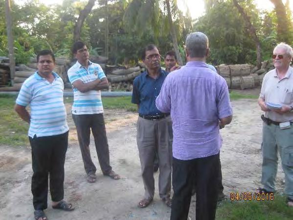
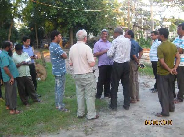
392 Photographs of Key Informant Interviews in Barisal PBS-2 95
Bhutan: Rural Renewable Energy Development Project (Part D Biogas Plants)
") Environmental Monitoring Report Annual Report November 2016 Bhutan: Rural Renewable Energy Development Project (Part D Biogas Plants) Prepared by the Department of Renewable Energy, Royal Government of
Environmental Monitoring Report Annual Report November 2016 Bhutan: Rural Renewable Energy Development Project (Part D Biogas Plants) Prepared by the Department of Renewable Energy, Royal Government of
ANNEXE 2: THE TERMS OF REFERENCE FOR ESIA AND RAP. 1. Objectives. The aim of the study is to achieve the following objectives:
 ANNEXE 2: THE TERMS OF REFERENCE FOR ESIA AND RAP 1. Objectives The aim of the study is to achieve the following objectives: Review of existing EIA and RAP reports on sections of the line which are not
Japanese ODA Loan. Ex-Ante evaluation
 Japanese ODA Loan Ex-Ante evaluation 1. Project Country: People's Republic of Bangladesh Name of the Project: Matarbari Ultra Super Critical Coal-Fired Power Project (I) Loan Agreement: June 16, 2014 Loan
TECHNICAL ASSISTANCE RAJASTHAN RENEWABLE ENERGY CAPACITY DEVELOPMENT AND IMPLEMENTATION SUPPORT
 TECHNICAL ASSISTANCE RAJASTHAN RENEWABLE ENERGY CAPACITY DEVELOPMENT AND IMPLEMENTATION SUPPORT A. Introduction 1. The State of Rajasthan is committed and poised to becoming a leader in the generation,
SECTOR ASSESSMENT (SUMMARY): TRANSPORT (RAIL TRANSPORT [NONURBAN])
![SECTOR ASSESSMENT (SUMMARY): TRANSPORT (RAIL TRANSPORT [NONURBAN])](/thumbs/76/73866832.jpg "SECTOR ASSESSMENT (SUMMARY): TRANSPORT (RAIL TRANSPORT [NONURBAN])") Railway Rolling Stock Project (RRP BAN 49094) SECTOR ASSESSMENT (SUMMARY): TRANSPORT (RAIL TRANSPORT [NONURBAN]) Sector Road Map 1. Sector Performance, Problems, and Opportunities 1. Bangladesh s transport
Railway Rolling Stock Project (RRP BAN 49094) SECTOR ASSESSMENT (SUMMARY): TRANSPORT (RAIL TRANSPORT [NONURBAN]) Sector Road Map 1. Sector Performance, Problems, and Opportunities 1. Bangladesh s transport
International Labour Organisation (ILO) Dhaka Promotion of Green Livelihoods for Ecologically Critical Area (ECA)
 Dhaka Promotion of Green Livelihoods for Ecologically Critical Area (ECA)") Three UN agencies namely UNDP, WFP and ILO have implemented a project Building Community Resilience Through Integrated Water Management which was funded by the Netherlands Government. As part of that project,
Three UN agencies namely UNDP, WFP and ILO have implemented a project Building Community Resilience Through Integrated Water Management which was funded by the Netherlands Government. As part of that project,
Initial Environmental Examination
 Initial Environmental Examination Document Stage: Update Project Number: P45203 (BAN) September 2016 People s Republic of Bangladesh: Natural Gas Infrastructure and Efficiency Improvement Project (Component
M/s Hind Energy & Coal Beneficiation Pvt. Ltd. is presently operating a 2 x 1.2 MTPA
 1.0 INTRODUCTION M/s Hind Energy & Coal Beneficiation Pvt. Ltd. is presently operating a 2 x 1.2 MTPA dry type of coal washery at Village: Hindadih, Tehsil: Masturi, District: Bilaspur (C.G.) for which
ENVIRONMENTAL IMPACT ASSESSMENT
 ENVIRONMENTAL IMPACT ASSESSMENT 240kWp Standalone AC-DC Coupled Solar Photovoltaic Based Mini Grid Power Plant by Super Star Renewable Energy Limited June, 2016 Prepared By Super Star Renewable Energy
12 Oct Virama Karya presentation on South Coast Highway. Therefore require a new route expressway
 in association with Design 151.66 Km (Existing Road Apr. 180 km) 2 OBJECTIVE: The Government of Timor Lestewishes to Engage Consultant to carry out the Preliminary, Detailed Engineering Design and Environment
SECTOR ASSESSMENT: WATER SUPPLY AND OTHER MUNICIPAL INFRASTRUCTURE AND SERVICES. 1. Sector Performance, Problems, and Opportunities
 Dhaka Environmentally Sustainable Water Supply Project (RRP BAN 42173) SECTOR ASSESSMENT: WATER SUPPLY AND OTHER MUNICIPAL INFRASTRUCTURE AND SERVICES Sector Road Map 1. Sector Performance, Problems, and
Transboundary Conservation of the mangrove ecosystem of Sundarbans
 Transboundary Conservation of the mangrove ecosystem of Sundarbans BANGLADESH Laskar Muqsudur Rahman Forest Department, BANGLADESH E-mail: laskarmr@yahoo.com Third Workshop on Water and Adaptation to Climate
Introduction. They can help ensure that all key issues and elements have been considered; They help ensure that the review process is systematic; and
 Introduction There are many tools that a reviewer of environmental impact assessment documents can use to help determine whether such documents are complete and adequate. Among the powerful tools that
Briefing Summary. Board Meeting on Nam Theun 2 Project: November 22, 2010
 Board Meeting on Nam Theun 2 Project: Briefing Summary November 22, 2010 Introduction The World Bank and Asian Development Bank (ADB) circulated a written Update on project progress to their respective
SECTOR ASSESSMENT (SUMMARY): ENERGY Sector Performance, Problems, and Opportunities
: ENERGY Sector Performance, Problems, and Opportunities") Interim Country Partnership Strategy: Mongolia, 2014 2016 SECTOR ASSESSMENT (SUMMARY): ENERGY 1 1. Sector Performance, Problems, and Opportunities 1. Low energy efficiency and urban air pollution. Presently,
Interim Country Partnership Strategy: Mongolia, 2014 2016 SECTOR ASSESSMENT (SUMMARY): ENERGY 1 1. Sector Performance, Problems, and Opportunities 1. Low energy efficiency and urban air pollution. Presently,
SECTOR ASSESSMENT (SUMMARY): ENERGY
: ENERGY") SECTOR ASSESSMENT (SUMMARY): ENERGY Country Partnership Strategy: Nepal, 2013-2017 A. Overview 1. Nepal has long recognized the development of its large hydropower potential as an important cornerstone
SECTOR ASSESSMENT (SUMMARY): ENERGY Country Partnership Strategy: Nepal, 2013-2017 A. Overview 1. Nepal has long recognized the development of its large hydropower potential as an important cornerstone
For PROPOSED IT PARK. By M/s.Balewadi Tech Park Pvt.Ltd. Submitted to State Environment Expert Appraisal Committee III, Maharashtra
 Draft Terms of References (ToR) (Based on the model TOR given in Environmental Impact Assessment Guidance Manual for building construction projects by MoEF & CC) For PROPOSED IT PARK By M/s.Balewadi Tech
Summary of Environmental and Social Consideration in Development Study (Preparatory Study)
") Summary of Environmental and Social Consideration in Development Study (Preparatory Study) 1. Full title of the Project The Study on Integrated Development Strategy for Danang City and Its Neighboring
Summary of Environmental and Social Consideration in Development Study (Preparatory Study) 1. Full title of the Project The Study on Integrated Development Strategy for Danang City and Its Neighboring
AMDAL Procedure. Flowchart of Indonesian Environmental Clearance 1
 AMDAL Procedure (This is only indicative and for reference purposes. This is not exhaustive and therefore, the Consultants are requested to familiarize themselves with all the laws, rules, regulations,
Environmental Impact Assessment of Hydroelectric Power Plant LEEZA MALIK (2013CEP2080) TUSHAR SINGLA (2011MT50623)
 TUSHAR SINGLA (2011MT50623)") Environmental Impact Assessment of Hydroelectric Power Plant LEEZA MALIK (2013CEP2080) TUSHAR SINGLA (2011MT50623) 1 Contents Background Objective EIA of Hydroelectric plants Tools and Techniques used
Environmental Impact Assessment of Hydroelectric Power Plant LEEZA MALIK (2013CEP2080) TUSHAR SINGLA (2011MT50623) 1 Contents Background Objective EIA of Hydroelectric plants Tools and Techniques used
ENVIRONMENT ACT TERMS OF REFERENCE NOVA SCOTIA DEPARTMENT OF TRANSPORTATION AND PUBLIC WORKS. Beaver Bank Bypass
 ENVIRONMENT ACT TERMS OF REFERENCE NOVA SCOTIA DEPARTMENT OF TRANSPORTATION AND PUBLIC WORKS Beaver Bank Bypass Highway 101 to the Beaver Bank Road Halifax County, NS NOVA SCOTIA DEPARTMENT OF THE ENVIRONMENT
Preliminary national diagnostic for environment statistics
 Preliminary national diagnostic for environment statistics Country : Bangladesh Presenter: : Md Solaiman Mondol Deputy Secretary Statistics and Informatics Division : Tufail Ahmed Deputy Director Bangladesh
Yes: Y No: N (a) (b) (c) (d) (a) (a) (b) (c) (d) (e)
 (b) (c) (d) (a) (a) (b) (c) (d) (e)") Checklist: 3. Hydropower Stations, Dams and Reservoirs (1) 1 Permits and Explanation 2 Pollution Control (1) EIA and Permits (2) Explanation to the Local Stakeholders Main Check s Have EIA reports been
Checklist: 3. Hydropower Stations, Dams and Reservoirs (1) 1 Permits and Explanation 2 Pollution Control (1) EIA and Permits (2) Explanation to the Local Stakeholders Main Check s Have EIA reports been
EA Frameworks Case Study
 EA Frameworks Case Study Tajikistan Community Agriculture & Watershed Management The World Bank Europe & Central Asia Region Biskek,Tblisi March/April 2008 Project Safeguard Policy Process Integrated Safeguards
FAQs on ESIA of CASA-1000
 FAQs on ESIA of CASA-1000 I. Technical Questions A. When will the project start in my (province/municipality/region)? The project implementation schedule will be finalized after selection of the contractor
Hind Energy & Coal Beneficiation (India) Ltd.
 Ltd.") SUMMARY ON ENVIRONMENTAL IMPACT ASSESSMENT REPORT OF Hind Energy & Coal Beneficiation (India) Ltd. 0.96 MTPA Wet type Coal Washery at Birgahani Village, Baloda Tehsil Janjgir-Champa District, Chhattisgarh
SUMMARY ON ENVIRONMENTAL IMPACT ASSESSMENT REPORT OF Hind Energy & Coal Beneficiation (India) Ltd. 0.96 MTPA Wet type Coal Washery at Birgahani Village, Baloda Tehsil Janjgir-Champa District, Chhattisgarh
Hind Energy & Coal Beneficiation (India) Ltd.
 Ltd.") SUMMARY ON ENVIRONMENTAL IMPACT ASSESSMENT REPORT OF Hind Energy & Coal Beneficiation (India) Ltd. (Change in Technology) at Hindadih Village, Masturi Tehsil Bilaspur District, Chhattisgarh Submitted to
SUMMARY ON ENVIRONMENTAL IMPACT ASSESSMENT REPORT OF Hind Energy & Coal Beneficiation (India) Ltd. (Change in Technology) at Hindadih Village, Masturi Tehsil Bilaspur District, Chhattisgarh Submitted to
Annex F Scoping Checklist
 Scoping Checklist Table F1: Scoping Checklist Table. Questions to be considered in Scoping /? Which Characteristics of the Project 1. Will construction, operation or decommissioning of the Project involve
Master Plan for Agricultural and Rural Development in the Southern Delta
 Draft (rev) -29 July 2010 Concept Note Master Plan for Agricultural and Rural Development in the Southern Delta Background information and rationale Bangladesh is part of the largest deltaic flood plain
ENVIRONMENTAL AND SOCIAL IMPACT ASSESSMENT GUIDELINES FOR HYDROPOWER PROJECTS IN MYANMAR
 ENVIRONMENTAL AND SOCIAL IMPACT ASSESSMENT GUIDELINES FOR HYDROPOWER PROJECTS IN MYANMAR Overview of Presentation 1. Objectives of the Consultancy 2. Hydropower in Myanmar 3. Draft Table of Contents 4.
The National Environment and Planning Agency (NEPA)
") The National Environment and Planning Agency (NEPA) Managing and protecting Jamaica s land wood and water ORGANIZATIONAL HISTORY The National Environment and Planning Agency (NEPA) is a new Executive Agency
The National Environment and Planning Agency (NEPA) Managing and protecting Jamaica s land wood and water ORGANIZATIONAL HISTORY The National Environment and Planning Agency (NEPA) is a new Executive Agency
Summary of Preparatory Study
 Summary of Preparatory Study 1. Title of the Cooperation Project, Relevant Project Report Preparatory Survey on the Project for the Establishment of Rural Water Supply System in Kambia Town in the Republic
H 6062 S T A T E O F R H O D E I S L A N D
 LC001 01 -- H 0 S T A T E O F R H O D E I S L A N D IN GENERAL ASSEMBLY JANUARY SESSION, A.D. 01 A N A C T RELATING TO AGRICULTURE AND FORESTRY - FARM CONSERVATION AND RENEWABLE ENERGY Introduced By: Representative
4.0 ENVIRONMENTAL IMPACTS AND MITIGATION MEASURES. Negative or adverse impacts during the construction phase are:
 4.0 ENVIRONMENTAL IMPACTS AND MITIGATION MEASURES 4.1 POTENTIAL ENVIRONMENTAL IMPACTS 4.1.1 Impacts during Construction Phase Negative or adverse impacts during the construction phase are: Land environment:
Sustainability Roadmap for Myanmar (Environment Perspective) Dr. San Oo Director Environmental Conservation Department 20 January 2015
 Dr. San Oo Director Environmental Conservation Department 20 January 2015") Sustainability Roadmap for Myanmar (Environment Perspective) Dr. San Oo Director Environmental Conservation Department 20 January 2015 1 Ministry of Environmental Conservation and Forestry (MOECAF) Environmental
Sustainability Roadmap for Myanmar (Environment Perspective) Dr. San Oo Director Environmental Conservation Department 20 January 2015 1 Ministry of Environmental Conservation and Forestry (MOECAF) Environmental
Ex-ante Project Evaluation
 Ex-ante Project Evaluation 1. Name of project Country: Socialist Republic of Vietnam Name of project: Hai Phong City Environmental Improvement Project (II) L/A signing date: March 31, 2009 Loan amount:
PROJECT CONCEPT PRELIMINARY QUESTIONAIRE PART I: GENERAL INFORMATION. GEF: OTHER(S) (Specify)
 (Specify)") PROJECT CONCEPT PRELIMINARY QUESTIONAIRE PART I: GENERAL INFORMATION Interested Organization Name: Project Location: Projected amount of required project funding ($ /USD): TOTAL: Project Sector or Similar:
PROJECT CONCEPT PRELIMINARY QUESTIONAIRE PART I: GENERAL INFORMATION Interested Organization Name: Project Location: Projected amount of required project funding ($ /USD): TOTAL: Project Sector or Similar:
CONSERVATION OF ENVIRONMENT ENACTMENT 1996 CONSERVATION OF ENVIRONMENT (PRESCRIBED ACTIVITIES) ORDER 1999
 ORDER 1999") (No. JPBN. 1509/27 Vol. II CONSERVATION OF ENVIRONMENT ENACTMENT 1996 CONSERVATION OF ENVIRONMENT (PRESCRIBED ACTIVITIES) ORDER 1999 In exercise of the powers conferred by section 5 of the Conservation
(No. JPBN. 1509/27 Vol. II CONSERVATION OF ENVIRONMENT ENACTMENT 1996 CONSERVATION OF ENVIRONMENT (PRESCRIBED ACTIVITIES) ORDER 1999 In exercise of the powers conferred by section 5 of the Conservation
Co-Benefit Approach in JICA
 Co-Benefit Approach in JICA The 18 th Asia-Pacific Seminar on Climate Change Ha Noi, 3th March 2009 by Akiko URAKAMI, Office for Climate Change Japan International Cooperation Agency (JICA) Table of Contents
STATE OF ENVIRONMENT ATLAS OF INDIA-OUTLINE
 STATE OF ENVIRONMENT ATLAS OF INDIA-OUTLINE Sl. No. Maps Themes Features Data Source I: GENERAL CHARACTERISTICS I. Administrative Divisions International, States, Districts Survey of Boundaries with State
Terms of Reference. Conflict Management and Mitigation for Energy Projects in Nepal
 Terms of Reference Conflict Management and Mitigation for Energy Projects in Nepal Background Nepal is a land-locked country that is facing major development challenges. With 27.8 million people, Nepal
Chapter 13 of Agenda 21
 Chapter 13 of Agenda 21 What is Agenda 21? Agenda 21 is the global plan of action that was adopted at the United Nations Conference on Environment and Development (UNCED) held in Rio de Janeiro, Brazil,
ENVIRONMENTAL IMPACT ASSESSMENT (EIA) Dr. B. K. Bindhani Assistant Professor KIIT School of Biotechnology KIIT University, Bhubaneswar, Orissa, India
 Dr. B. K. Bindhani Assistant Professor KIIT School of Biotechnology KIIT University, Bhubaneswar, Orissa, India") ENVIRONMENTAL IMPACT ASSESSMENT (EIA) Dr. B. K. Bindhani Assistant Professor KIIT School of Biotechnology KIIT University, Bhubaneswar, Orissa, India Review: Definition of EIA Environmental Impact Assessment
ENVIRONMENTAL IMPACT ASSESSMENT (EIA) Dr. B. K. Bindhani Assistant Professor KIIT School of Biotechnology KIIT University, Bhubaneswar, Orissa, India Review: Definition of EIA Environmental Impact Assessment
Information Document Service Proposals and Cost Estimating ID # R
 Information Documents are not authoritative. Information Documents are for information purposes only and are intended to provide guidance. In the event of any discrepancy between an Information Document
Ukraine Sustainable Energy Lending Facility (USELF) Strategic Environmental Review (SER) Ecoline EA Centre
 Strategic Environmental Review (SER) Ecoline EA Centre") Ukraine Sustainable Energy Lending Facility (USELF) Strategic Environmental Review (SER) Ecoline EA Centre Objectives of Strategic Environmental Review (SER) The European Bank for Reconstruction and Development
Ukraine Sustainable Energy Lending Facility (USELF) Strategic Environmental Review (SER) Ecoline EA Centre Objectives of Strategic Environmental Review (SER) The European Bank for Reconstruction and Development
Lesotho Highlands Water Project. Refiloe Tlali Chief Executive LHDA 22 May 2015
 Lesotho Highlands Water Project Refiloe Tlali Chief Executive LHDA 22 May 2015 Today s roadmap Why the LHWP? What is the mandate? How is LHDA governed? What has been achieved? Where to from here? Why the
ARTICLE 16 - WIND ENERGY CONVERSION FACILITIES
 ARTICLE 16 - WIND ENERGY CONVERSION FACILITIES SECTION 1601 Wind Energy Installation In any zoning district, a conditional use permit or building permit may be granted to allow a wind energy conversion
PROJECT INFORMATION DOCUMENT (PID) APPRAISAL STAGE. Lahendong II Geothermal Power Project
 APPRAISAL STAGE. Lahendong II Geothermal Power Project") Public Disclosure Authorized Public Disclosure Authorized Public Disclosure Authorized Public Disclosure Authorized Project Name PROJECT INFORMATION DOCUMENT (PID) APPRAISAL STAGE Lahendong II Geothermal
Public Disclosure Authorized Public Disclosure Authorized Public Disclosure Authorized Public Disclosure Authorized Project Name PROJECT INFORMATION DOCUMENT (PID) APPRAISAL STAGE Lahendong II Geothermal
SEA and Green Growth The African Development Bank Experience
 SEA and Green Growth The African Development Bank Experience Presented By Justin Ecaat, Principal Environmental Safeguards Officer Lusaka, Zambia. January 2013 Content Background: SEA: Beyond project level
Final Environmental Impact Assessment Report
 NON-TECHNICAL SUMMARY... I 1 INTRODUCTION... 1 1.1 BACKGROUND... 1 1.2 PROJECT IMPLEMENTATION SCHEDULE... 2 1.3 COST ESTIMATE... 2 1.4 KEY LEGISLATIVE, REGULATORY AND INSTITUTIONAL FRAMEWORK... 2 1.4.1
Name of project: Climate Adaptation for Biodiversity, Ecosystem Services and Livelihoods in Rural Madagascar
 Name of project: Climate Adaptation for Biodiversity, Ecosystem Services and Livelihoods in Rural Madagascar Overall objectives: Assist Madagascar to improve its understanding and assessment of the impacts
4 PROJECT ALTERNATIVES
 4 PROJECT ALTERNATIVES 4.1 Introduction In terms of the EIA Regulations published in Government Notice R543 of 2 August 2010 in terms of Section 24 of the National Environmental Management Act (Act No.
ENVIRONMENTAL MONITORING PROGRAMME
 Stage-I (2x800 MW) Page 1 5 CHAPTER - VI ENVIRONMENTAL MONITORING PROGRAMME 6.0 OBJECTIVES Regular monitoring program the environmental parameters is essential to take into account the changes in the environment.
SB 838: Oregon Renewable Energy Act Establishing an Oregon Renewable Energy Standard
 SB 838: Oregon Renewable Energy Act Establishing an Oregon Renewable Energy Standard Section-by-Section Summary SB 838, C-engrossed version As passed by Oregon House of Representatives, May 23 rd, 2007.
PROPOSED TERM OF REFERENCE
 PROPOSED TERM OF REFERENCE FOR ESTABLISHMENT OF PROPOSED MOLASSES/GRAIN BASED DISTILLERY HAVING CAPACITY: 160.0 KLD (MOLASSES BASED) OR 120.0 KLD (MOLASSES BASED) + 40.0 KLD (GRAIN BASED) ALONGWITH 7.0
Land Accounting for SDG Monitoring and Reporting
 Regional Expert Workshop on Land Accounting for SDG Monitoring and Reporting Bangkok - Thailand 25-27 September 2017 Mrs. Niroshinie De Silva Assistant Director Ministry of Mahaweli development & Environment
Case of MIGA s Guarantee Linked to the Engineering and Feasibility Phase of Developing the PT Weda Bay Nickel Project. Summary
 APPRAISAL REPORT CAO Appraisal for Audit of MIGA CAO Compliance October 3, 2011 PT Weda Bay Nickel Indonesia Case of MIGA s Guarantee Linked to the Engineering and Feasibility Phase of Developing the PT
Annex 1: Project Tropicalia Sustainable Tourism, Dominican Republic
 Annex 1: Project Tropicalia Sustainable Tourism, Dominican Republic and Social Action Plan (ESAP) Item PS 1: Assessment and Management of and Social Risks and Impacts 1.1 and Social Management System (ESMS)
Dying fisheries in a changing environment: A study on livelihood strategies of fishery communities in Mumbai, India.
 Dying fisheries in a changing environment: A study on livelihood strategies of fishery communities in Mumbai, India. Sibananda Senapati and Vijaya Gupta National Institute of Industrial Engineering (NITIE)
UZB: Second Central Asia Regional Economic Cooperation Corridor 2 Road Investment Program
 Second Central Asia Regional Economic Cooperation Corridor 2 Road Investment Program (RRP UZB 44483) Ethnic Minority Planning Framework May 2011 UZB: Second Central Asia Regional Economic Cooperation Corridor
Dang Thi Tuoi Biodiversity Conservation Agency (BCA) Ministry of Natural Resources and Environment of Vietnam (MONRE)
 Ministry of Natural Resources and Environment of Vietnam (MONRE)") Dang Thi Tuoi Biodiversity Conservation Agency (BCA) Ministry of Natural Resources and Environment of Vietnam (MONRE) Main Contents: 1. Roles of biodiversity in Vietnam 2. Threats to biodiversity in Vietnam
Dang Thi Tuoi Biodiversity Conservation Agency (BCA) Ministry of Natural Resources and Environment of Vietnam (MONRE) Main Contents: 1. Roles of biodiversity in Vietnam 2. Threats to biodiversity in Vietnam
Outline for. Protected Areas Management Planning
 Outline for Protected Areas Management Planning Level One: Community-based protected area management organizations and Level Two: Conservation organizations / Non-governmental organizations Outline for
INTEGRATED SAFEGUARDS DATA SHEET CONCEPT STAGE
 Public Disclosure Authorized Public Disclosure Authorized Public Disclosure Authorized Public Disclosure Authorized INTEGRATED SAFEGUARDS DATA SHEET CONCEPT STAGE Date ISDS Prepared/Updated: 23-Jul-2014
PANCHESHWAR MULTIPURPOSE PROJECT
 ANNEXURE-VIII PROPOSED TERMS OF REFERENCE FOR CONDUCTING CEIA STUDY FOR PANCHESWAR MULTI-PURPOSE PROJECT 1. GENERAL The Environmental Impact Assessment of the proposed Pancheswar Multi-purpose project
Soil and Water Conservation/ Watershed Management
 Vandna B.Tech., 6 th Semester Department of Civil Engineering JNGEC Sundernagar, Mandi (H.P.) 175018 ABSTRACT The watershed is a geographical area through which water flows in the form of streams, rivers,
3.0 Planning and Submittal Requirements
 October 2003, Revised February 2005 Chapter 3.0, Planning and Submittal Requirements Page 1 3.0 Planning and Submittal Requirements 3.1 Drainage Studies and Drawings The City of Greenwood Village (Village)
BCI Criterion 4.2. Smallholders. Conversion Risk Assessment Procedure. Version 0.1
 BCI Criterion 4.2 Conversion Risk Assessment Procedure Smallholders Version 0.1 Identification Name of producer: Name of Production Unit: Location (administrative unit, province/state and country): Area
CONTENTS CHAPTER : ONE. 1-9 CHAPTER : TWO.10-16
 CONTENTS LIST OF TABLES Page No. CHAPTER : ONE. 1-9 ENVIRONMENT STATISTICS: FRAME WORK AND INDICATORS. 1 1.3.1 Framework for Development of Environment Statistics (FDES) Information categories 3 1.3.2
The First Mekong River Commission Summit 2010
 15th Anniversary 5 April 1995 5 April 2010 The First Mekong River Commission Summit 2010 The Mekong Basin as a source of economic prosperity The water resources of the 795,000 square kilometer Mekong Basin
Role of Climate Smart Agriculture in achieving Land Degradation Neutrality in Sri Lanka. Champika S Kariyawasam
 Role of Climate Smart Agriculture in achieving Land Degradation Neutrality in Sri Lanka Champika S Kariyawasam Land Degradation Neutrality- Global Developments 2012 - UN Conference on Sustainable Development
Environmental and Social Considerations in Detailed Planning Survey. (Technical Cooperation for Development Planning)
") Page: 1 Date: May 27, 2014 Environmental and Social Considerations in Detailed Planning Survey (Technical Cooperation for Development Planning) 1. Full Title of the Project 2. Type of the study (e.g. Master
Page: 1 Date: May 27, 2014 Environmental and Social Considerations in Detailed Planning Survey (Technical Cooperation for Development Planning) 1. Full Title of the Project 2. Type of the study (e.g. Master
Comprehensive Study Scoping Document. for Lower Mattagami Hydroelectric Complex Redevelopment CEAR Reference Number:
 Comprehensive Study Scoping Document for Lower Mattagami Hydroelectric Complex Redevelopment CEAR Reference Number: 07-03-26302 Prepared pursuant to Subsection 21(1) of the Canadian Environmental Assessment
Environmental and Social Impact Assessment for Rogun Hydro Power Plant
 Environmental and Social Impact Assessment for Rogun Hydro Power Plant Environmental and Social Impacts July 14-19, 2014 Content Project History Purpose and Scope The Project Area The Project The Project
Concept of Flood Shelter to Cope with Flood
 M. A. Ali, S. M. Seraj and S. Ahmad (eds): ISBN 984-823-002-5 Concept of Flood Shelter to Cope with Flood M. J. B. Alam and Md. Hossain Ali Department of Civil Engineering Bangladesh University of Engineering
1. Name of the Project 2. Necessity and Relevance of JBIC s Assistance 3. Project Objectives
 Ex-ante Evaluation 1. Name of the Project Country: India Project: Swan River Integrated Watershed Management Project (Loan Agreement: 03/31/2006; Loan Amount: 3,493 million yen; Borrower: The President
MARINE POLLUTION DEGRADATION MITIGATION MANAGEMENT IS ESSENTIAL FOR IMPROVING MARINE ENVIRONMENT
 MARINE POLLUTION DEGRADATION MITIGATION MANAGEMENT IS ESSENTIAL FOR IMPROVING MARINE ENVIRONMENT The health of the world s oceans and marine life is degrading rapidly as a result of excess human activities.
Effects of sluice gate on fisheries and crops production at Jugini CPP Area, Tangail, Bangladesh
 International Journal of Biosciences IJB ISSN: 2220-6655 (Print) 2222-5234 (Online) http://www.innspub.net Vol. 4, No. 8, p. 8-13, 2014 RESEARCH PAPER OPEN ACCESS Effects of sluice gate on fisheries and
ENVIRONMENTAL LEGAL ASPECTS OF DOING BUSINESS IN MEXICO
 ENVIRONMENTAL LEGAL ASPECTS OF DOING BUSINESS IN MEXICO By: Héctor Herrera, Ph.D. Admitted in Mexico 9/29/2015 1 2014 Haynes and Boone, LLP 31 STATES AND 1 FEDERAL DISTRICT 2 NATIONAL TERRITORY 3 LAWS
STATE UNIVERSITY CONSTRUCTION FUND
 STATE UNIVERSITY CONSTRUCTION FUND The following checklist show the general items required by the Agreement and the Program Directives. Unless included in the lump sum fee or the Schedule B of the Consultant
TERMS OF REFERENCE. Identification of the sources of pollution and assessing the impacts on the environment due to proposed project if any;
 TERMS OF REFERENCE 1.0 PROPOSED SCOPE OF WORK FOR EIA STUDY The components of the EIA study include: Determination of baseline data using primary data generation and secondary data available from various
Environmental Checklist:. 10.Ports and Harbors (1) Yes: Y No: N (a) (b) (c) (d)
 Yes: Y No: N (a) (b) (c) (d)") Checklist:. 10.Ports and Harbors (1) 1 Permits and Explanation 2 Pollution Control (1) EIA and Permits (2) Explanation to the Local Stakeholders (3) Examination of Alternatives (1) Air Quality (2) Water
Checklist:. 10.Ports and Harbors (1) 1 Permits and Explanation 2 Pollution Control (1) EIA and Permits (2) Explanation to the Local Stakeholders (3) Examination of Alternatives (1) Air Quality (2) Water
LIST OF TABLES NUMBE R CHAPTER 1- ENVIRONMENT AND ENVIRONMENT DEGRADATION
 LIST OF TABLES NAME PAGE NUMBE R CHAPTER 1- ENVIRONMENT AND ENVIRONMENT DEGRADATION TABLE 1.3.1 FRAMEWORK FOR DEVELOPMENT OF ENVIRONMENT STATISTICS (FDES) INFORMATION CATEGORIES TABLE 1.3.2: SOME IMPACTS
EIA implementation and Follow-up
 EIA implementation and follow up: a case study of Koga irrigation and watershed management project- Ethiopia By: W.B. Abebe, W.J.A.M. Douven, M.McCartney, J. Leentvaar This research was done for the partial
The following potential environmental receptors and impacts form the basis of TRCA s review under Ontario Regulation 166/06 and the Fisheries Act:
 TRCA Technical Guidelines for the Development of Environmental Management Plans for Dewatering September 2013 Rationale: The Technical Guidelines for the Development of Environmental Management Plans for
Causes and possible solutions of poverty perceived by char dwellers in Bangladesh
 International Journal of Natural and Social Sciences 2 (2015) 37-41 ISSN: 2313-4461 Causes and possible solutions of poverty perceived by char dwellers in Bangladesh Md. Nazirul Islam Sarker 1,4 *, Md.
Ex-Ante Evaluation (for Japanese ODA Loan)
") Japanese ODA Loan Ex-Ante Evaluation (for Japanese ODA Loan 1.Name of the Project Country: The Republic of Indonesia Project: Upper Citarum Basin Flood Management Sector Loan Loan Agreement: March 28,
Japanese ODA Loan Ex-Ante Evaluation (for Japanese ODA Loan 1.Name of the Project Country: The Republic of Indonesia Project: Upper Citarum Basin Flood Management Sector Loan Loan Agreement: March 28,
Environment and Climate Change Adaptation and Mitigation in Myanmar. SAN WIN Assistant Director Environmental Conservation Department 23 August, 2014
 Environment and Climate Change Adaptation and Mitigation in Myanmar SAN WIN Assistant Director Environmental Conservation Department 23 August, 2014 Presentation Outlines Background and Environmental Governance
Socio-economic Indicators for Vulnerability Assessment in the Arab Region
 Socio-economic Indicators for Vulnerability Assessment in the Arab Region Tarek Sadek Water Resources Section Sustainable Development & Productivity Division-ESCWA Presentation outline Concepts of vulnerability
Appendix 1: Scoping Techniques
 Appendix 1: Scoping Techniques 1 Scoping Techniques Checklist technique Checklist technique is used for identifying the project impacts. Such lists usually cover all possible impacts of the project. In
Total No. of Questions : 5] [Total No. of Printed Pages : 2 [3683]-1. P. G. D. E. M. (Semester - I) Examination
![Total No. of Questions : 5] [Total No. of Printed Pages : 2 [3683]-1. P. G. D. E. M. (Semester - I) Examination](/thumbs/71/65533074.jpg "Total No. of Questions : 5] [Total No. of Printed Pages : 2 [3683]-1. P. G. D. E. M. (Semester - I) Examination") Total No. of Questions : 5] [Total No. of Printed Pages : 2 [3683]-1 P. G. D. E. M. (Semester - I) Examination - 2009 ENVIRONMENTAL MANAGEMENT TECHNIQUES - I (1) Answer any four questions. (3) Use of calculator
Total No. of Questions : 5] [Total No. of Printed Pages : 2 [3683]-1 P. G. D. E. M. (Semester - I) Examination - 2009 ENVIRONMENTAL MANAGEMENT TECHNIQUES - I (1) Answer any four questions. (3) Use of calculator
EXECUTIVE SUMMARY 1.0 PROJECT DESCRIPTION 1.1 INTRODUCTION
 EXECUTIVE SUMMARY 1.0 PROJECT DESCRIPTION 1.1 INTRODUCTION Jaypee Group is a leading Business House of the country with its presence in Core industries and Service Sectors like Cement, Infrastructure development,
SECTOR ASSESSMENT (SUMMARY): POWER Sector Performance, Problems, and Opportunities
: POWER Sector Performance, Problems, and Opportunities") Country Partnership Strategy: Papua New Guinea, 2011 2015 SECTOR ASSESSMENT (SUMMARY): POWER 1 Sector Road Map 1. Sector Performance, Problems, and Opportunities 1. In Papua New Guinea (PNG), less than
Country Partnership Strategy: Papua New Guinea, 2011 2015 SECTOR ASSESSMENT (SUMMARY): POWER 1 Sector Road Map 1. Sector Performance, Problems, and Opportunities 1. In Papua New Guinea (PNG), less than
MILLENNIUM DEVELOPMENT GOALS AND CLIMATE CHANGE ADAPTATION
 MILLENNIUM DEVELOPMENT GOALS AND CLIMATE CHANGE ADAPTATION THE CONTRIBUTION OF UNDP-GEF ADAPTATION INITIATIVES TOWARDS MDG1 Issue No.1: Eradicate Extreme Poverty and Hunger - from Climate Change United
Land Acquisition and Resettlement Due Diligence Report
 Land Acquisition and Resettlement Due Diligence Report Document stage: Draft Project number: July 2017 IND: Kolkata Environmental Improvement Investment Program Construction of Sewage Treatment Plant at
.in Dated 9th August, Sharma ;
 F. No. J-11011/151/2010-IA II (I) Government of India Ministry of Environment and Forests (I.A. Division) Paryavaran Bhawan CGO Complex, Lodhi Road New Delhi -110 003.. To, Ankleshwar E-mail: pb.rastoai@nic.in
TEMA LIQUEFIED NATURAL GAS PROJECT ENVIRONMENTAL AND SOCIAL IMPACT ASSESSMENT
 TEMA LIQUEFIED NATURAL GAS PROJECT ENVIRONMENTAL AND SOCIAL IMPACT ASSESSMENT Final Scoping Report - Non-Technical Summary Presentation Structure of the Presentation Introduction to the Tema LNG Project
Agricultural Production Standard (APS) At a Glance
 At a Glance") Agricultural Production Standard (APS) At a Glance Fair Trade USA Version 1.0.0 June 2017 Introduction to Fair Trade USA and the APS What is Fair Trade USA? Fair Trade USA is a nonprofit organization and
Agricultural Production Standard (APS) At a Glance Fair Trade USA Version 1.0.0 June 2017 Introduction to Fair Trade USA and the APS What is Fair Trade USA? Fair Trade USA is a nonprofit organization and
Processing unit (fish products)
") EXECUTIVE SUMMARY E1. INTRODUCTION The Proponent, Ferme Marine de Mahebourg Ltd (FMM), is involved in the Fish Farming sector in Mauritius since 2000. To date, FMM manages two declared Fish Farm Zones
EXECUTIVE SUMMARY E1. INTRODUCTION The Proponent, Ferme Marine de Mahebourg Ltd (FMM), is involved in the Fish Farming sector in Mauritius since 2000. To date, FMM manages two declared Fish Farm Zones
FOOD SECURITY CONDITION OF LANDLESS PEOPLE IN A CHAR AREA OF RANGPUR DISTRICT ABSTRACT
 Progress. Agric. 24(1 & 2): 281 289, 213 ISSN 117-8139 FOOD SECURITY CONDITION OF LANDLESS PEOPLE IN A CHAR AREA OF RANGPUR DISTRICT M. Shahiduzzaman 1, M. Z. Rahman 2 *, M. J. Hoque 3 and M. S. Arefin