Supplemental Watershed Plan Agreement No. 10 for Neshaminy Creek Watershed Core Creek Dam (PA-620) Bucks County, Pennsylvania
|
|
|
- Irene Wiggins
- 6 years ago
- Views:
Transcription
 Bucks")
1 Supplemental Watershed Plan Agreement No. 10 for Neshaminy Creek Watershed Core Creek Dam (PA-620) Bucks County, Pennsylvania
2 Project Authorization USDA's Small Watershed Program is carried out under the authority of the Watershed Protection and Flood Prevention Act of 1954; Public Law The watershed program helps communities meet local resource needs, including: Flood protection & Control for agricultural land and urban areas Fish and wildlife habitat Conservation practices & Water quality improvement Irrigation & Water supply Water-based recreation & Recreational areas Erosion and sediment control Project Program PL , the Small Watershed Rehabilitation Amendments of 2000, which amends PL , Watershed Protection and Flood Prevention Act.

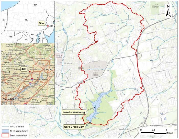
3 Project Location
4 Project Objectives Meet or exceed state and federal dams safety criteria. Maintain or enhance the current level of flood protection. Maintain or enhance water supply storage. Maintain the current recreation opportunities. Maintain aquatic wildlife and terrestrial wildlife habitat.
5 Project Purpose Maintain or improve the current level of flood damage reduction provided by the Core Creek Dam (PA-620) for public safety, bridges, roads, agricultural and other lands, buildings, structures, infrastructure, and other features. Maintain or improve the recreational and habitat values of Lake Luxembourg and adjacent riparian lands. Comply with current applicable design, performance and safety criteria for High Hazard Class dams. Maintain the water supply availability provided by the Core Creek Dam and Lake Luxembourg.
6 Project Need Continue providing flood damage reduction downstream from the dam and address applicable NRCS and Commonwealth of Pennsylvania standards and design criteria for public health and safety to reduce the risk of loss of human life. Continue supporting and improving the recreational uses and aquatic and terrestrial wildlife habitat directly dependent upon Lake Luxembourg and its surrounding riparian lands. Continue providing public water supply availability from Core Creek Dam and Lake Luxembourg.
7 Rehabilitation Planning Process Local input Sponsor determines objectives Public scoping meetings Establish problems and opportunities Detailed planning study Topographic Surveys Habitat assessments Sediment study Dam safety inspection Engineering analysis of structure and appurtenances Hydrologic and hydraulic modeling Water supply reviews Consideration of breach inundation studies Formulate alternatives Review local input
8 Alternatives Considered 1) No Action/Future without Federal project 2) Federal decommissioning with other downstream measures 4) Relocate the downstream structures potentially impacted 5) Floodproof downstream structures potentially impacted
9 Goals for Rehabilitation Rehabilitate the dam to current NRCS High Hazard Class dam design criteria. Extend the service life for at-least an additional 50 years. Enhance the current water supply storage. Comply with PA-DEP dam safety regulations.
10 Rehabilitation Alternatives Feature Existing Condition Alt. 1 Alt. 2 Alt. 3 Alt. 4 Alt. 5 Alt. 6 Alt. 7 Top of Dam Elevation (feet) Maximum Water Surface Elevation (feet) Auxiliary Spillway Crest Width (feet) Auxiliary Spillway Crest Elevation (feet) Principal Spillway Conduit Length (feet) Estimated Percent of Least Cost Alternative , A 430 B 550 C N/A 655% 123% 226% 144% 100% 203% 156% A Alternative 5 uses a labyrinth weir to provide a total crest length of 2,229 feet within the actual spillway width of 550 feet. B Alternative 6 uses a labyrinth weir to provide a total crest length of 2,540 feet within the actual spillway width of 430 feet. C Alternative 7 uses Fusegate (labyrinth style) to provide a similar flow capacity to a labyrinth weir option. The maximum WSEL is estimated based on the design for the Alternative 5 labyrinth weir. A more detailed design could be prepared in the future with the consultation of the Fusegate manufacturer, Hydroplus.
11 Rehabilitation Maintain existing dam at current location and crest Elevation Extend the service life for an additional 57 years. Replace the Auxiliary Spillway control section with a labyrinth weir. Armor the Auxiliary Spillway downstream of the labyrinth weir with roller compacted concrete. Construct an upstream cutoff wall, downstream scour protection, and a riprap apron. Reinforce the downstream face of the embankment with fill at 3.75H:1V slope. Extend the existing Principal Spillway conduit and the existing toe drain conduits. Construct a new S.A.F. Basin at the outlet of the Principal Spillway conduit.
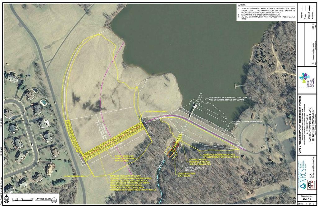
12 Rehabilitation

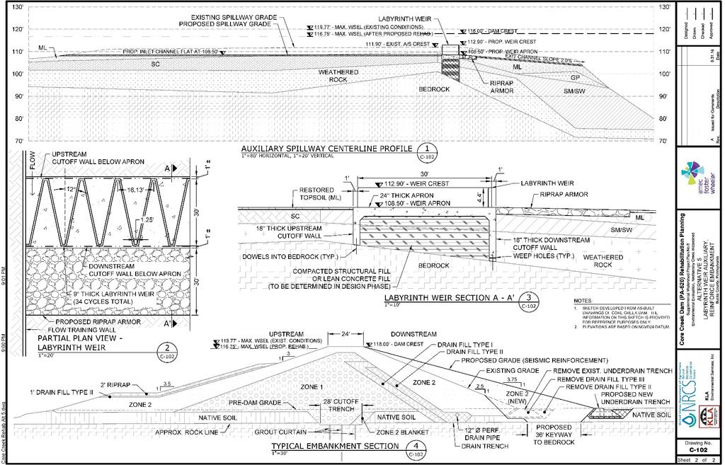
13 Rehabilitation
14 Rehabilitation to Current High Hazard Class Dam Criteria Feature Existing Condition Alternative 5 Top of Dam Elevation (feet) Maximum Water Surface Elevation (feet) Auxiliary Spillway Crest Width (feet) 550 2,229-foot weir length Auxiliary Spillway Type Vegetated Earth Labyrinth Weir Auxiliary Spillway Crest Elevation (feet) Principal Spillway Conduit Diameter (inches) Principal Spillway Conduit Length (feet) Principal Spillway Riser Type Single Stage Single Stage Principal Spillway Conduit Type Reinforce Concrete Pipe Reinforce Concrete Pipe Estimated Installation Cost $6,187,500
15 Preferred Alternative Proposal for your consideration: Rehabilitate Core Creek Dam (PA-620) to current High Hazard Class dam design criteria. Extend the service life for an additional 57 years plus 3 years implementation time. Comply with PADEP dam safety regulations. Agenda
Informational Meeting- March 31, Boxelder B-2/B-3 Watershed Planning Study
 Informational Meeting- March 31, 2016 Boxelder B-2/B-3 Watershed Planning Study Agenda Introductions Work Completed to Date Phase 1 Evaluations Alternatives Evaluations Economic Evaluations Draft Watershed
Informational Meeting- July 21, Boxelder B-2/B-3 Watershed Planning Study
 Informational Meeting- July 21, 2015 Boxelder B-2/B-3 Watershed Planning Study Agenda Introductions Background & History Purpose & Need NRCS Watershed Planning Program Work Completed to Date Longer term
Notice No Closing Date: May 12, 2017
 Public Notice U.S. Army Corps of Engineers Pittsburgh District In Reply Refer to Notice No. below US Army Corps of Engineers, Pittsburgh District 1000 Liberty Avenue Pittsburgh, PA 15222-4186 Application
Lyon Creek Cedar Way Stormwater Detention Dam Operation and Maintenance Manual
 Lyon Creek Cedar Way Stormwater Detention Dam Operation and Maintenance Manual Prepared by: Mike Shaw Stormwater Program Manager City of Mountlake Terrace January 2010 Section I General Information This
INFLOW DESIGN FLOOD CONTROL SYSTEM PLAN 40 C.F.R. PART PLANT YATES ASH POND 3 (AP-3) GEORGIA POWER COMPANY
 GEORGIA POWER COMPANY") INFLOW DESIGN FLOOD CONTROL SYSTEM PLAN 40 C.F.R. PART 257.82 PLANT YATES ASH POND 3 (AP-3) GEORGIA POWER COMPANY EPA s Disposal of Coal Combustion Residuals from Electric Utilities Final Rule (40 C.F.R.
INFLOW DESIGN FLOOD CONTROL SYSTEM PLAN 40 C.F.R. PART 257.82 PLANT YATES ASH POND 3 (AP-3) GEORGIA POWER COMPANY EPA s Disposal of Coal Combustion Residuals from Electric Utilities Final Rule (40 C.F.R.
Visual Inspection Checklist
 APPENDIX Q. Visual Inspection Checklist Thispageintentionallyleftblank. VISUAL INSPECTION CHECKLIST CITY OF AUBURN PUBLIC WORKS DEPARTMENT INSPECTION YEAR: TYPE OF INSPECTION: (Informal, Regular, Formal):
Ponds. Pond A water impoundment made by excavating a pit, or constructing a dam or an embankment.
 POND SITE SELECTION AND CONSTRUCTION Uses, Planning, & Design David Krietemeyer Area Engineer USDA-NRCS June 20, 2008 Uses Considerations for Location of Commonly Used Terms Pond A water impoundment made
United States Army Corps of Engineers. Addicks and Barker Dam Safety Update
 United States Army Corps of Engineers Addicks and Barker Dam Safety Update COL Richard P. Pannell District Commander, Galveston District U.S. Army Corps of Engineers March 9, 2016 US Army Corps of Engineers
ROLES AND RESPONSIBILITIES Small Pond Approval. SWM MD-378 Pond Checklist Training 10/17/07. Exemptions EMBANKMENT HEIGHT. Height of Dam Weir Wall
 SWM MD-378 Pond Checklist Training 10/17/07 Ken Wolfe Warren Johnson USDA, NRCS Frederick, Maryland ROLES AND RESPONSIBILITIES Small Pond Approval MDE, WMA, Dam Safety Division Authority (COMAR 26.17.04.03)
Construction Inspection Checklists
 III. Construction Inspection Checklists 33 Bioretention - Construction Inspection Checklist Project: Location: Site Status: Date: Time: Inspector: Construction Sequence Satisfactory / Unsatisfactory Comments
Volume 2, Chapter 10 - Storage
 Volume 2, Chapter 10 - Storage Users Guidance: If a UDFCD Section number in this chapter is skipped: It was adopted as is; please refer to that Section in the corresponding UDFCD Manual, Volume, Chapter
V. DRAINAGE IMPROVEMENTS
 V. DRAINAGE IMPROVEMENTS 5.1 Formulation of Drainage Improvements As indicated in Chapter 4, following the completion of the hydrologic analysis associated with future land use conditions, drainage improvements
Temporary Watercourse Crossing: Culverts
 Temporary Watercourse Crossing: Culverts DRAINAGE CONTROL TECHNIQUE Low Gradient Velocity Control Short Term Steep Gradient Channel Lining Medium-Long Term Outlet Control Soil Treatment Permanent Symbol
INFLOW DESIGN FLOOD CONTROL SYSTEM PLAN PLANT BARRY ASH POND ALABAMA POWER COMPANY
 INFLOW DESIGN FLOOD CONTROL SYSTEM PLAN PLANT BARRY ASH POND ALABAMA POWER COMPANY Section 257.82 of EPA s regulations requires the owner or operator of an existing or new CCR surface impoundment or any
INFLOW DESIGN FLOOD CONTROL SYSTEM PLAN 40 C.F.R. PART PLANT YATES ASH POND B (AP-B ) GEORGIA POWER COMPANY
 GEORGIA POWER COMPANY") INFLOW DESIGN FLOOD CONTROL SYSTEM PLAN 40 C.F.R. PART 257.82 PLANT YATES ASH POND B (AP-B ) GEORGIA POWER COMPANY EPA s Disposal of Coal Combustion Residuals from Electric Utilities Final Rule (40 C.F.R.
INFLOW DESIGN FLOOD CONTROL SYSTEM PLAN 40 C.F.R. PART 257.82 PLANT YATES ASH POND B (AP-B ) GEORGIA POWER COMPANY EPA s Disposal of Coal Combustion Residuals from Electric Utilities Final Rule (40 C.F.R.
Rapid Drawdown at Embankment Dams, Is it a REAL Concern?
 Rapid Drawdown at Embankment Dams, Is it a REAL Concern? Cari Beenenga, P.E., Principal Geotechnical Engineer, Gannett Fleming, Inc. Andy Deichert, P.E., State Conservation Officer, West Virginia NRCS
ENGINEERING CHECKLIST SEDIMENT & STORMWATER MANAGEMENT BASIN CONSTRUCTION
 NEW CASTLE COUNTY DEPARTMENT OF LAND USE ENGINEERING CHECKLIST SEDIMENT & STORMWATER MANAGEMENT BASIN CONSTRUCTION For Permanent Structures, pursuant to Delaware Pond Code 378 and Delaware Sediment and
Mill Pond Dam Modifications Feasibility Study
 May 1, 2013 Mill Pond Dam Modifications Feasibility Study Village of Goodrich, MI Table of Contents 1. Background...1 1.1 Michigan Department of Environmental Quality (MDEQ) Regulation Dam Safety Unit
APPENDIX A EARTHEN EMBANKMENT. VERSION 1.0 March 1, 2011
 APPENDIX A EARTHEN EMBANKMENT VERSION 1.0 March 1, 2011 SECTION A-1: DESCRIPTION OF PRACTICE An earthen embankment is a raised impounding structure made from compacted soil. The embankment is the feature
DAM INSPECTION CHECKLIST Department of Environmental Protection Bureau of Waterways Engineering Division of Dam Safety
 DAM INSPECTION CHECKLIST Department of Environmental Protection Bureau of Waterways Engineering Division of Dam Safety NAME OF DAM: Milltown Dam DEPDAMNO.: 15-146 LOCATION: Municipality: East Goshen Township
Sediment Basin. Fe= (Depends on soil type)
") 3.9 Sediment Control Description: A sediment basin is an embankment with a controlled outlet that detains stormwater runoff, resulting in the settling of suspended sediment. The basin provides treatment
3.9 Sediment Control Description: A sediment basin is an embankment with a controlled outlet that detains stormwater runoff, resulting in the settling of suspended sediment. The basin provides treatment
Created by Simpo PDF Creator Pro (unregistered version) Asst.Prof.Dr. Jaafar S. Maatooq
 Asst.Prof.Dr. Jaafar S. Maatooq") Lect.No.9 2 nd Semester Barrages, Regulators, Dams 1 of 15 In order to harness the water potential of a river optimally, it is necessary to construct two types of hydraulic structures, as shown in Figure
Lect.No.9 2 nd Semester Barrages, Regulators, Dams 1 of 15 In order to harness the water potential of a river optimally, it is necessary to construct two types of hydraulic structures, as shown in Figure
Chapter 11 Culverts and Bridges
 Chapter 11 Culverts and Bridges Contents 1.0 Introduction... 1 2.0 General Design... 1 2.1 Design Criteria... 1 2.2 Design Flows... 1 2.3 Permitting and Regulations... 1 2.4 Aesthetics and Safety... 2
DEPARTMENT OF ENVIRONMENTAL PROTECTION Bureau of Water Quality Protection. Design Criteria - Wetlands Replacement/Monitoring
 DEPARTMENT OF ENVIRONMENTAL PROTECTION Bureau of Water Quality Protection DOCUMENT NUMBER: 363-0300-001 TITLE: Design Criteria - Wetlands Replacement/Monitoring EFFECTIVE DATE: February 11, 1997 AUTHORITY:
Water Control Structures Selected Design Guidelines Alberta Environment Page 17-1
 Alberta Transportation Water Control Structures Selected Design Guidelines Alberta Environment Page 17-1 17.0 MAIN CANAL CONVEYANCE STRUCTURES 17.1 General Conveyance structures typically employed on main
Prepared for Urban Drainage and Flood Control District
 BERM FAILURE TECHNICAL ANALYSES SOUTH PLATTE GRAVEL PIT EVALUATION CRITERIA Prepared for Urban Drainage and Flood Control District Wright Water Engineers, Inc. January 2013 121-030.000 TABLE OF CONTENTS
SECTION 3 DRAINAGE. 3-1 General. 3-2 Drainage Ordinances and Legal Requirements
 SECTION 3 DRAINAGE 3-1 General All Drainage plans for proposed development shall be prepared by a Professional Engineer registered in Virginia, except as noted below. Further, their seal and signature
TEMPORARY SEDIMENT TRAP CODE
 ILLINOIS URBAN MANUAL PRACTICE STANDARD TEMPORARY SEDIMENT TRAP CODE 960 Source: DEFINITION A small temporary stormwater storage structure designed to trap sediment. PURPOSE The purpose of this practice
Standards for Soil Erosion and Sediment Control in New Jersey May 2012 STANDARD FOR SLOPE PROTECTION STRUCTURES. Definition
 STANDARD FOR SLOPE PROTECTION STRUCTURES Definition Structures to safely conduct surface runoff from the top of a slope to the bottom of the slope. Purpose The purpose of this practice is to convey storm
POND CONSTRUCTION. Woodland Steward Series
 POND CONSTRUCTION Woodland Steward Series BOB TWOMEY DISTRICT CONSERVATIONIST USDA NATURAL RESOURCES CONSERVATION SERVICE COURSE OUTLINE DEFINITION OF A POND OR LAKE TYPES OF PONDS GEOLOGIC CONSIDERATIONS
New Castle County, DE. Floodplain Regulations
 New Castle County, DE Floodplain Regulations John J. Gysling, PE CFM Department of Land Use New Castle County, DE February 26, 2009 Today s Presentation Floodplain Protection and Uses Terms and Definitions
III. INVENTORY OF EXISTING FACILITIES
 III. INVENTORY OF EXISTING FACILITIES Within the Growth Management Boundary, the existing storm drainage facilities are largely associated with development that has historically occurred in the ten drainage
ARTICLE V: STORMWATER MANAGEMENT AND DRAINAGE SYSTEMS
 ARTICLE V: STORMWATER MANAGEMENT AND DRAINAGE SYSTEMS Section 501: Purpose An adequate drainage system including necessary ditches, pipes, culverts, drains, inlets, bridges, detention ponds, etc. shall
RIPARIAN CORRIDOR STUDY FINAL CITY CREEK MANAGEMENT PLAN TABLE OF CONTENTS
 TABLE OF CONTENTS 1.0 INTRODUCTION... 1-1 Riparian Corridor Study and Management Plan Goals... 1-1 Study Area... 1-2 Importance and Functions of Riparian Corridors... 1-2 Habitat for Mammals, Birds, and
Chapter 12 Storage. Contents. Overview... 1
 Chapter 12 Storage Contents Overview... 1 Implementation of Regional, Sub-regional, and On-site Detention Facilities... 2 Regional Detention... 2 Subregional Detention... 5 Onsite Detention... 6 Detention
TVA Colbert Fossil Facility Ash Disposal Pond 4
 2011 World of Coal Ash (WOCA) Conference May 9-12, 2011 in Denver, CO, USA http://www.flyash.info/ TVA Colbert Fossil Facility Ash Disposal Pond 4 Improving Operations While Preparing for Closure May 10,
Lower San Joaquin River Feasibility Study PLAN FORMULATION ADDENDUM
 PLAN FORMULATION ADDENDUM Non-Structural Measure Descriptions Elevate Critical Infrastructure This measure would raise at-risk critical structures above the design inundation level. Elevation would be
Information for File # PRH
 Information for File # 2016-02602-PRH Applicant Corps Contact Tom Morley Paul Hauser Address 152 Baker Drive, Redwood Falls, MN 56283 E-Mail Paul.R.Hauser@usace.army.mil Phone 651-290-5357 Primary County
NOTICE OF PREPARATION
 NOTICE OF PREPARATION Date: June 12, 2014 To: From: Subject: Governor s Office of Planning and Research/State Clearinghouse Unit, Responsible Agencies, Trustee Agencies, and Interested Parties Announcement
Filter Tube Barriers (Instream)
") Filter Tube Barriers (Instream) INSTREAM PRACTICES Flow Control No Channel Flow Dry Channels Erosion Control Low Channel Flows Shallow Water Sediment Control High Channel Flows Deep Water Symbol Photo
Filter Tube Barriers (Instream) INSTREAM PRACTICES Flow Control No Channel Flow Dry Channels Erosion Control Low Channel Flows Shallow Water Sediment Control High Channel Flows Deep Water Symbol Photo
COON CREEK WATERSHED DISTRICT PERMIT REVIEW. Spring Lake Park Schools Westwood Middle School st Avenue NE, Spring Lake Park, MN 55432
 PAN 16-112, Westwood Middle School, Page 1 of 6 COON CREEK WATERSHED DISTRICT PERMIT REVIEW MEETING DATE: August 22, 2016 AGENDA NUMBER: 10 FILE NUMBER: 16-112 ITEM: Westwood Middle School RECOMMENDATION:
Dam Safety Inspection Checklist
 Dam Safety Inspection Checklist Complete All Portions of This Section (Pre-inspection) Date of Inspection: Name of Dam: EAP: (yes, no) OM&I: (yes, no) File Number: Review Inventory - Highlight missing
Types of Inspections. Prior to Inspection. Types of Inspections. Typical Inspection Equipment. Embankment Dams
 BIA Summer Water Resources Training Dam Safety Inspections Part 4 - Inspections July 28, 2012 Presented by Michael Johnson, Ph.D., P.E. Types of Inspections Periodic Inspections A comprehensive visual
LOW WATER CROSSINGS, fords, or drifts, as they
 Chapter 9 For ords and Low-Water Crossings Keep the ford profile low, armor the driving surface, and protect against scour. LOW WATER CROSSINGS, fords, or drifts, as they are commonly called, can offer
Extended Detention Basin (EDB) Sedimentation Facility
 Sedimentation Facility") Extended Detention Basin (EDB) Sedimentation Facility Description An extended detention basin (EDB) is a sedimentation basin designed to totally drain dry sometime after stormwater runoff ends. It is an
Extended Detention Basin (EDB) Sedimentation Facility Description An extended detention basin (EDB) is a sedimentation basin designed to totally drain dry sometime after stormwater runoff ends. It is an
DTE Energy St. Clair Power Plant
 DTE Energy St. Clair Power Plant Unit 6 Scrubber Basins CCR Rule Compliance Project Annual Inspection Report - 2017 Project Number: 60546402 June 30, 2017 Prepared by: 27777 Franklin Road, Suite 2000 Southfield,
Holly Swartz and Jason Shirey
 Chapter 105 General Permits for Stream and Wetland Impacts DEP Ch. 105 CONTACTS FOR BERKS COUNTY: Holly Swartz and Jason Shirey What DEP Regulates Under Chapter 105 Waters of the Commonwealth, which includes
Coal Combustion Facility Assessment Report. October 20, 2010
 Coal Combustion Facility Assessment Report October 20, 2010 Introduction Stantec Consulting Services Inc. North American Consulting Firm 10,000 Engineers, Geologists, Architects, Scientists and Technicians
9.2 STANDARD CONSTRUCTED WETLANDS
 9.2 STANDARD CONSTRUCTED WETLANDS Standard constructed wetlands are stormwater management systems designed to maximize the removal of pollutants from stormwater runoff. Flow is directed through an engineered,
Constructed Wetland Pond T-8
 Constructed Wetland Pond T-8 Description A constructed wetlands pond is a shallow retention pond designed to permit the growth of wetland plants such as rushes, willows, and cattails. Constructed wetlands
Looking at Dam Safety from a Resiliency Perspective. February 23, 2017
 Looking at Dam Safety from a Resiliency Perspective February 23, 2017 1 Discussion Outline Dam Safety 101 (10 min) Fort Hood Overview (5 min) Resiliency Framework (5 min) Fort Hood Dam Safety Program (15
Constructed Wetland Use in Nonpoint Source Control
 Constructed Wetland Use in Nonpoint Source Control Description Constructed wetlands are excavated basins with irregular perimeters and undulating bottom contours into which wetland vegetation is purposely
q Item meets standard Project ID: X Item not acceptable Contractor: N/A Item not applicable Inspector: C Item requires engineer s cert.
 SEDIMENT/STORMWATER MANAGEMENT BASIN CONSTRUCTION CHECKLIST For permanent structures per Delaware SCS Pond Code 378 and Delaware Sediment and Stormwater Regulations KEY PROJECT INFORMATION q Item meets
Dam Failure Hazard Profile
 Appendix F Dam Failure Hazard Profile F-1 THIS PAGE INTENTIONALLY LEFT BLANK F-2 4.3.12. Dam Failure 4.3.12.1. Location and Extent Dam failures most often occur during or after a massive rainfall, flooding,
SECTION 11: REGULATORY FLOODWAYS
 SECTION 11: REGULATORY FLOODWAYS Contents 11.1. The Floodway... 11-2 11.1.1. The floodway concept... 11-2 11.1.2. Floodway map... 11-2 11.1.3. Floodway permitting... 11-3 11.1.4. Changing the floodway...
Dam Safety & Planning: Examples of Collaboration and Lessons Learned
 US Army Corps of Engineers PLANNING SMART BUILDING STRONG Dam Safety & Planning: Examples of Collaboration and Lessons Learned Eric Halpin, P.E. Special Assistant for Dam & Levee Safety, HQUSACE Maria
Kentucky Dam Safety and Floodplain Compliance
 Kentucky Dam Safety and Floodplain Compliance Celebrating 10 years KAMM Conference September 10, 2014 Brian Shane Cook, PE, LSIT Kentucky Division of Water (502) 564-3410 ext 4822 Shane.Cook@ky.gov WHY
RIPARIAN CORRIDOR STUDY FINAL PARLEYS CREEK MANAGEMENT PLAN TABLE OF CONTENTS
 TABLE OF CONTENTS 1.0 INTRODUCTION... 1-1 Riparian Corridor Study and Management Plan Goals... 1-1 Study Area... 1-2 Importance and Functions of Riparian Corridors... 1-2 Habitat for Mammals, Birds, and
DAM SAFETY INSPECTION REPORT GLENWOOD LAKE DAM CLASS B, INTERMEDIATE HAZARD DAM
 May 1, 2013 DAM SAFETY INSPECTION REPORT GLENWOOD LAKE DAM CLASS B, INTERMEDIATE HAZARD DAM Name of Dam: Glenwood Lake Dam Westchester County, NY, NYSDEC ID No. 215-0184 NATDAM ID No. NY13618 Hazard Potential:
SANTA ANA RIVER/ SAN TIMOTEO CREEK 1 LEVEE SYSTEM SAN BERNARDINO COUNTY, CALIFORNIA NLD SYSTEM ID #
 SANTA ANA RIVER/ SAN TIMOTEO CREEK 1 LEVEE SYSTEM SAN BERNARDINO COUNTY, CALIFORNIA NLD SYSTEM ID # 3805030015 PERIODIC INSPECTION REPORT NO. 1 GENERALIZED EXECUTIVE SUMMARY FINAL SYSTEM RATING: UNACCEPTABLE
Stormwater Local Design Manual For Houston County, Georgia
 Stormwater Local Design Manual For Houston County, Georgia Adopted November 15, 2005 TABLE OF CONTENTS 1. FORWARD... 1 2. GENERAL LEVEL OF SERVICE STANDARDS... 2 2.1. DETENTION REQUIREMENTS... 2 2.1.1.
Green River Diversion Rehabilitation
 USDA Natural Resources Conservation Service-Utah Wallace F. Bennett Federal Building 125 S. State Street Room 4010 Salt Lake City, UT 84138-1100 Green River Diversion Rehabilitation National Environmental
June 22, Francis E. Borcalli, P.E.
 CACHE CREEK SETTLING BASIN SYMPOSIUM Managing the Settling Basin Who s Doing What! June 22, 2009 Francis E. Borcalli, P.E. CACHE CREEK SETTLING BASIN SYMPOSIUM Managing the Settling Basin Who s Doing What!
Good morning, Chairman Yaw, Chairman Yudichak, Chairman Vulakovich, Chairman Costa,
 Testimony of Patrick McDonnell, Secretary Pennsylvania Department of Environmental Protection Joint Hearing on Flooding and Emergency Response Senate Environmental Resources & Energy and Veterans Affairs
In re: Town of Norwich Pool Dam Reconstruction, Stream Alteration Permit Application
 Agency of Natural Resources October 20, 2015 Neil R. Fulton Town Manager Town of Norwich P.O. Box 376 Norwich, VT 05055 In re: Town of Norwich Pool Dam Reconstruction, Stream Alteration Permit Application
MODEL Stormwater Local Design Manual. City of Centerville
 MODEL Stormwater Local Design Manual City of Centerville Adopted December 6, 2005 TABLE OF CONTENTS 1. FORWARD... 1 2. GENERAL LEVEL OF SERVICE STANDARDS... 1 2.1. DETENTION REQUIREMENTS... 1 2.1.1. Discharge
Application for resource consent Form B Damming and diversion of water
 Application for resource consent Form B Damming and diversion of water Notes Resource use activities must meet all the conditions of any relevant Permitted Activity Rules in the Waikato Regional Plan or
SKAGIT COUNTY PLANNING AND DEVELOPMENT SERVICES FINDINGS OF FACT. APPLICATION NUMBER: Shoreline Substantial Development Application PL
 SKAGIT COUNTY PLANNING AND DEVELOPMENT SERVICES FINDINGS OF FACT HEARING AUTHORITY: Skagit County Hearing Examiner HEARING DATE: April 24, 2013 APPLICATION NUMBER: Shoreline Substantial Development Application
Farmington Dam Repurpose Project
 Farmington Dam Repurpose Project 2017 $158,100,000 to re-purpose the Farmington Dam from flood protection only to a long-term water storage facility that increases water supply reliability to the region.
SECTION STORM DRAINAGE DESIGN, GRADING, AND WATER QUALITY TECHNICAL CRITERIA TABLE OF CONTENTS PAGE 402 STORM DRAINAGE DESIGN CRITERIA 400-1
 CITY OF THORNTON Standards and Specifications Revised: October 2012 SECTION 400 - STORM DRAINAGE DESIGN, GRADING, AND WATER QUALITY TECHNICAL CRITERIA TABLE OF CONTENTS PAGE 401 GENERAL PROVISIONS 400-1
Honeysuckle Reservoir decommissioning
 Honeysuckle Reservoir decommissioning Christopher Dwyer Earth Tech, PO Box 165 Wangaratta, 3676. Web: www.earthtech.com.au, Email: chris.dwyer@earthtech.com.au Abstract Often significant investment is
Appendix D - Evaluation of Interim Solutions
 Appendix D - Evaluation of Interim Solutions D.1 Introduction The implementation of long-term improvements is projected to take 5 to 8 years. To reduce the number of years of flooding impacts, the partner
STREAMBANK RESTORATION DESIGN
 STREAMBANK RESTORATION DESIGN WITH VINYL SHEET PILE GRADE CONTROL STRUCTURES BRUCE M. PHILLIPS, M.S., P.E. ABSTRACT Grade control structures are an effective channel stabilization measure which can eliminate
Appendix J Hydrology and Hydraulics
 Appendix J Hydrology and Hydraulics Marsh Lake Dam Ecosystems Restoration Feasibility Study Hydraulics & Hydrology Appendix January 2011 Contents List of Figures iii List of Tables iii I. General 1 II.
Municipal Stormwater Ordinances Summary Table
 APPENDIX F Municipal Ordinances Summary Table Municipality Abington Bryn Athyn Borough Hatboro Borough Ordinance, SALDO Runoff equals pre post Erosion Sediment Control Water Quality Requirements Any which
INFLOW DESIGN FLOOD CONTROL SYSTEM PLAN 40 C.F.R. PART PLANT BOWEN ASH POND 1 (AP-1) GEORGIA POWER COMPANY
 GEORGIA POWER COMPANY") INFLOW DESIGN FLOOD CONTROL SYSTEM PLAN 40 C.F.R. PART 257.82 PLANT BOWEN ASH POND 1 (AP-1) GEORGIA POWER COMPANY EPA s Disposal of Coal Combustion Residuals from Electric Utilities Final Rule (40 C.F.R.
INFLOW DESIGN FLOOD CONTROL SYSTEM PLAN 40 C.F.R. PART 257.82 PLANT BOWEN ASH POND 1 (AP-1) GEORGIA POWER COMPANY EPA s Disposal of Coal Combustion Residuals from Electric Utilities Final Rule (40 C.F.R.
Municipal Class Environmental Assessment for Pottersburg Creek Slope Stability Study South of Hamilton Road, Schedule B
 Municipal Class Environmental Assessment for Pottersburg Creek Slope Stability Study South of Hamilton Road, Schedule B February 13, 2013 Municipal Class EA Process We are here Purpose and Objective of
Freight Street Development Strategy
 Freight Street Development Strategy Appendix B: Naugatuck River Floodplain Analysis Freight Street Development Strategy DECEMBER 2017 Page B-1 1.0 NAUGATUCK RIVER FLOODPLAIN AT FREIGHT STREET 1.1 Watershed
NEW CASTLE CONSERVATION DISTRICT. through. (Name of Municipality) PLAN REVIEW APPLICATION DRAINAGE, STORMWATER MANAGEMENT, EROSION & SEDIMENT CONTROL
 PLAN REVIEW APPLICATION DRAINAGE, STORMWATER MANAGEMENT, EROSION & SEDIMENT CONTROL") NEW CASTLE CONSERVATION DISTRICT through (Name of Municipality) PLAN REVIEW APPLICATION DRAINAGE, STORMWATER MANAGEMENT, EROSION & SEDIMENT CONTROL Office use only: Received by Municipality: Received by
NEW CASTLE CONSERVATION DISTRICT through (Name of Municipality) PLAN REVIEW APPLICATION DRAINAGE, STORMWATER MANAGEMENT, EROSION & SEDIMENT CONTROL Office use only: Received by Municipality: Received by
Table of Contents. 5-5 Release Rates Year Allowable Release Rate WQCV Release Rate EURV Release Rate...
 Chapter 5 Table of Contents 5-1 Introduction... 1 5-1-1 Stormwater Quality Considerations... 1 5-1-2 Stormwater Volume Considerations... 2 5-1-3 Downstream Impacts... 2 5-2 Requirements... 2 5-2-1 General
(b) Discuss in brief shaft spillway with neat sketches. Marks 04. OR Q (2) Explain in brief USBR stilling basin. Marks 08
 Discuss in brief shaft spillway with neat sketches. Marks 04. OR Q (2) Explain in brief USBR stilling basin. Marks 08") (b) Discuss in brief shaft spillway with neat sketches. Marks 04 OR Q (2) Explain in brief USBR stilling basin. Marks 08 Stilling Basins The basins are usually provided with special appurtenances including
(b) Discuss in brief shaft spillway with neat sketches. Marks 04 OR Q (2) Explain in brief USBR stilling basin. Marks 08 Stilling Basins The basins are usually provided with special appurtenances including
Table of Contents. Attachments Attachment A Photos Attachment B Site Map. Pages 3 of 9
 Table of Contents 1.0 Introduction...4 2.0 Description of Landfill...4 3.0 Review of Available Information...5 4.0 Inspection...5 4.1 Changes in Geometry since Last Inspection...5 4.2 Volume...5 4.3 Definitions
Table of Contents. Attachments Attachment A Photos Attachment B Inspection Map. Pages 3 of 10
 Table of Contents 1.0 Introduction...4 2.0 Description of Landfill...4 3.0 Review of Available Information...5 4.0 Inspection...5 4.1 Changes in Geometry since Last Inspection...5 4.2 Volume...5 4.3 Definitions
Hydrology and Flooding
 Hydrology and Flooding Background The 1996 flood Between February 4, 1996 and February 9, 1996 the Nehalem reporting station received 28.9 inches of rain. Approximately 14 inches fell in one 48 hour period.
PRENTISS CREEK (SUB-E) KENSINGTON PLACE CONCEPT PLAN VILLAGE OF DOWNERS GROVE, ILLINOIS AUGUST, 2011
 KENSINGTON PLACE CONCEPT PLAN VILLAGE OF DOWNERS GROVE, ILLINOIS AUGUST, 2011") PRENTISS CREEK (SUB-E) KENSINGTON PLACE CONCEPT PLAN VILLAGE OF DOWNERS GROVE, ILLINOIS AUGUST, 2011 Submitted to: NATHANIEL HAWK, STAFF ENGINEER VILLAGE OF DOWNERS GROVE 5101 WALNUT AVENUE DOWNERS GROVE,
PRENTISS CREEK (SUB-E) KENSINGTON PLACE CONCEPT PLAN VILLAGE OF DOWNERS GROVE, ILLINOIS AUGUST, 2011 Submitted to: NATHANIEL HAWK, STAFF ENGINEER VILLAGE OF DOWNERS GROVE 5101 WALNUT AVENUE DOWNERS GROVE,
PAPERWORK REDUCTION ACT A. GENERAL
 U.S. DEPARTMENT OF HOMELAND SECURITY - FEDERAL EMERGENCY MANAGEMENT AGENCY RIVERINE STRUCTURES FORM O.M.B No. 1660-0016 Expires: 12/31/2010 PAPERWORK REDUCTION ACT Public reporting burden for this form
APPENDIX A HYDROLOGIC AND HYDRAULIC ANALYSIS
 APPENDIX A HYDROLOGIC AND HYDRAULIC ANALYSIS GENERAL The Hydrologic and Hydraulic information presented in this appendix is provided as a supplement to the Dallas Floodway Extension General Re-evaluation
REROUTING DRAINAGE SYSTEMS
 MINNESOTA WETLAND RESTORATION GUIDE REROUTING DRAINAGE SYSTEMS TECHNICAL GUIDANCE DOCUMENT Document No.: WRG 4A-4 Publication Date: 10/14/2015 Table of Contents Introduction Application Design Considerations
f) Culverts in series shall be spaced at least 20 feet between each other. 2.7 C Culverts
 Culverts in series shall be spaced at least 20 feet between each other. 2.7 C Culverts") 2.7 C Culverts 1. General Culverts are intended to safely pass flow under road crossings. Criteria are designed to protect, maintain, and enhance public health, safety, and the environment. Where culverts
2.7 C Culverts 1. General Culverts are intended to safely pass flow under road crossings. Criteria are designed to protect, maintain, and enhance public health, safety, and the environment. Where culverts
DRAFT GREATER MOOSES TOOTH TWO (GMT2) DEVELOPMENT PROJECT PERMITTEE RESPONSIBLE WETLANDS MITIGATION PLAN NATIONAL PETROLEUM RESERVE-ALASKA
 DEVELOPMENT PROJECT PERMITTEE RESPONSIBLE WETLANDS MITIGATION PLAN NATIONAL PETROLEUM RESERVE-ALASKA") DRAFT GREATER MOOSES TOOTH TWO (GMT2) DEVELOPMENT PROJECT PERMITTEE RESPONSIBLE WETLANDS MITIGATION PLAN NATIONAL PETROLEUM RESERVE-ALASKA Prepared for: ConocoPhillips Alaska, Inc. Anchorage, AK March
DRAFT GREATER MOOSES TOOTH TWO (GMT2) DEVELOPMENT PROJECT PERMITTEE RESPONSIBLE WETLANDS MITIGATION PLAN NATIONAL PETROLEUM RESERVE-ALASKA Prepared for: ConocoPhillips Alaska, Inc. Anchorage, AK March
Public Notice ISSUED: June 29, 2017 EXPIRES: July 31, 2017
 SPONSOR: Gary Pestorious Public Notice ISSUED: June 29, 2017 EXPIRES: July 31, 2017 REFER TO: 2012-01634-DAS SECTION:404 - Clean Water Act 1. WETLAND COMPENSATORY MITIGATION BANK PROPOSAL: Pickerel Lake
a landowner whose parcel was subjected to the discharge of a neighbor's ditch which was being used to drain a swamp;
 PA Act 167 Watershed Stormwater Management Planning DEFINITION Stormwater management has been traditionally defined as measures used by property owners and local governments to limit the amount of stormwater
Will be modified map from GIS 6/16 EOD
 Middle-Snake-Tamarac Rivers Watershed District Judicial Ditch #19 Watershed Regional Conservation Partnership Program (RCPP) Public Scoping Meeting September 26, 2016 Will be modified map from GIS 6/16
Phase II Report on Hydrology, Hydraulics, and Low Water Dams
 Phase II Report on Hydrology, Hydraulics, and Low Water Dams Arkansas River Corridor Tulsa, OK May 2005 Submitted To: U. S. Army Corps of Engineers Tulsa District Prepared by: The GUERNSEY Team 5555 N.
Dam Maintenance Fact Sheet
 C O L O R A D O P A R K S & W I L D L I F E Dam Maintenance Fact Sheet 5-YR PARKS AND WILDLIFE FUNDING PROPOSAL FOR DAMS Colorado Parks and Wildlife (CPW) owns and operates over 110 dams (100 Wildlife,
Stream Reaches and Hydrologic Units
 Chapter United States 6 Department of Agriculture Natural Resources Conservation Service Chapter 6 Stream Reaches and Hydrologic Units Rain clouds Cloud formation Precipitation Surface runoff Evaporation
IAFSM 2010 Annual Conference. City of Rockford Keith Creek Greenway Flood Mitigation Project
 IAFSM 2010 Annual Conference City of Rockford Keith Creek Greenway Flood Mitigation Project March 10, 2010 Introduction Problem Overview 1890 s Building of homes along Keith Creek 1920 s Home construction
SEMINAR ON WATER SECURITY IN BULGARIA SOFIA, SEPTEMBER 18-19, 2017 DAM SAFETY IN ROMANIA
 SEMINAR ON WATER SECURITY IN BULGARIA SOFIA, SEPTEMBER 18-19, 2017 DAM SAFETY IN ROMANIA Overview Romania has built 2,617 dams out of which 246 are large and medium dams and 1260 are small dams, as per
DIVISION 5 STORM DRAINAGE CRITERIA
 DIVISION 5 STORM DRAINAGE CRITERIA Section 5.01 GENERAL The following storm drainage design criteria shall apply to all storm drainage designs in the City. Additional design criteria are specified in the
Erosion and Sediment Control Plan for a Timber Harvesting Operation
 3930-FM-WM0155 Rev. 7/2004 Erosion and Sediment Control Plan for a Timber Harvesting Operation 1. GENERAL INFORMATION A. Location Municipality B. Timber sale area = acres Date County C. Landowner Name