USING BEAVER DAM ANALOGS TO REDUCE DOWNSTREAM SEDIMENT LOADS
|
|
|
- Abigail Miles
- 6 years ago
- Views:
Transcription
1 USING BEAVER DAM ANALOGS TO REDUCE DOWNSTREAM SEDIMENT LOADS A Pilot Project in California Creek, Spokane, Washington, USA Sue Niezgoda, Ph.D., P.E. Associate Professor of Civil Engineering Gonzaga University
 Lakes, wetlands, estuaries, off-channel tribs, etc. WOOD!")
2 Beaver Optimum Habitat Requirements WATER!!! Small- to medium, lowgradient streams (<6% slope) Lakes, wetlands, estuaries, off-channel tribs, etc. WOOD!!! Developed riparian areas that contain (1) vegetation for food, and (2) potential construction materials to build dams and lodges.


3 Beaver Dams! Created to impound water around lodge Dam location / repair cued by running water Dams constructed of wood and available debris (e.g., plastic, metal) Where palatable species are rare, conifers are used more in dams, with hardwoods saved for the food cache (Barnes and Mallik 1996)


4 World s Larger Beaver Dam Found in Alberta, Canada (2007) using Google Earth 850 m; longer than Hoover Dam


5 Benefits of Beaver Dams Bouwes et al. (2015)
 Beaver Restoration Guidebook")
6 Beaver Dam Viability Pollack et al. (2015) Beaver Restoration Guidebook


7 What are Beaver Dam Analogs? Structures completely or partially built by humans that mimic many of the functions of natural beaver dams
 Material cost and labor = $500-$5000/structure Size of structure (length) Size of stream (depth of posts) Source distance of")
8 BDA Materials and Equipment Materials-similar to beaver dams Willow branches Herbaceous vegetation Rocks, mud Wood posts (typically non-treated) Equipment needed Chainsaw-to cut and sharpen posts Hand saws to cut willow Post pounder/power source (hydraulic or pneumatic) Material cost and labor = $500-$5000/structure Size of structure (length) Size of stream (depth of posts) Source distance of building materials Labor costs Students FREE LABOR!


9 Sediment Trapping in Hangman Creek Watershed, Spokane WA, USA Facts 1780 sq. km sq. km. of dryland agriculture 358 km of perennial streams Issues Major changes in vegetation Altered hydrology - flashy Easily erodible soils Ag Lands Glacial Lake Deposits Human impacts Q 2 = 184 cms Q 10 = 370 cms Q 100 = 600 cms


10 Hangman Creek Flashy Hydrology Large Sediment Supply Nine Mile Dam Spokane River Spokane River


 study to test")

11 Hangman Creek - California Creek BDA Pilot Study Research Goal Examine effectiveness and sustainability of BDAs to enhance ecosystem benefits and reduce sediment loads and erosion in California Creek and the Hangman Creek Watershed. Research Objectives Collect preliminary monitoring data in California Creek to help establish a long-term intensely monitored watershed (BACI) study to test sediment trapping hypotheses in the larger Hangman Creek Watershed Develop structural design guidelines for BDAs in a variety of stream reaches with varying stream power
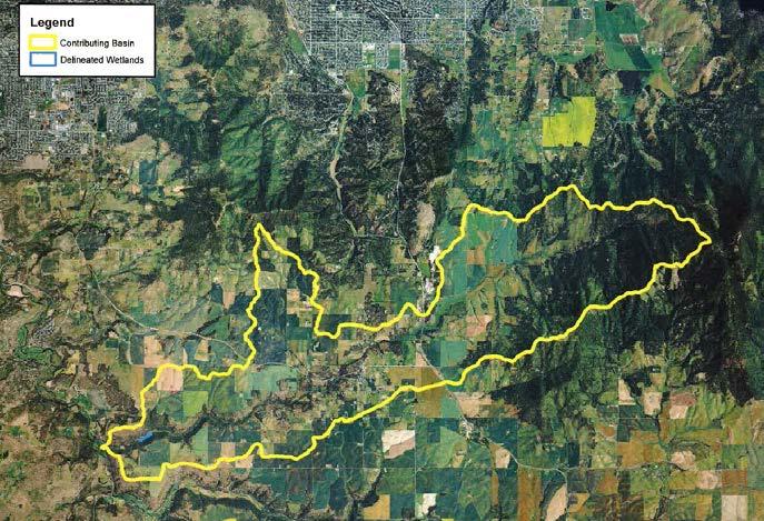
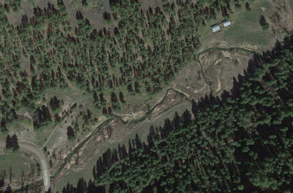

12 California Creek BDA Locations installed Sept 2016


13 California Creek Monitoring Plan Set Hypotheses Sediment Trapping Water Storage Reduced Erosion Develop Monitoring Plan Methods, Equipment, Personnel QA/QC Implement Monitoring Plan Analyze and Synthesize Results Adaptively Manage Monitoring Feedback into Adaptively Managing BDAs 1 st round of data collected Fall 2016 Drum roll please....


14 Spring Flood Feb 16-17, 2017 Rain on Snow Event Hangman Creek 10,000 cfs 5-year Event California Creek Landowner haven t seen flows this high in 30 years! Drone Video


15 BDA Adaptive Management - Extend width of each existing BDA and reinforce/rebuild - Use hydraulic modeling and drone footage: - Adjust BDA angles to be more effective - Add in 2-4 additional BDAs Yellow existing Red proposed Blue newly installed
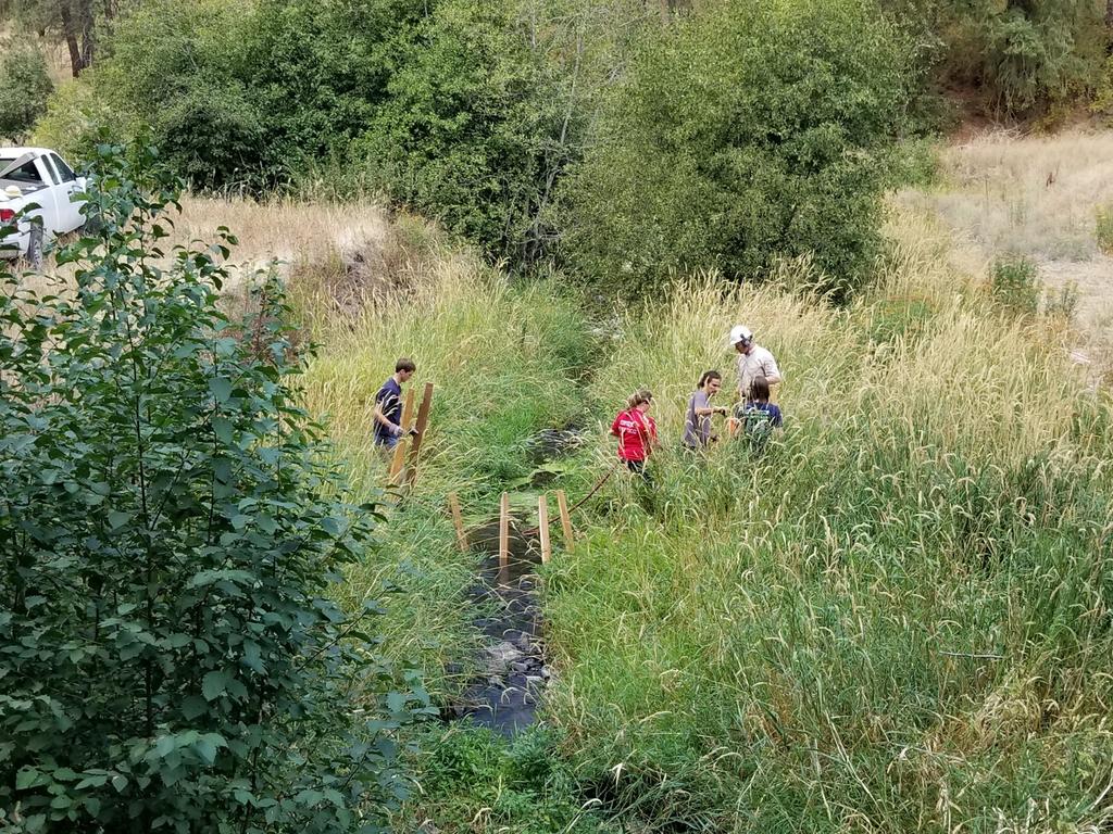
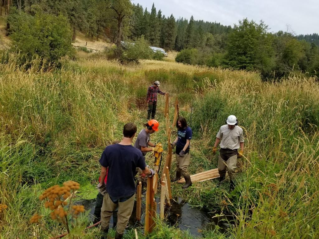
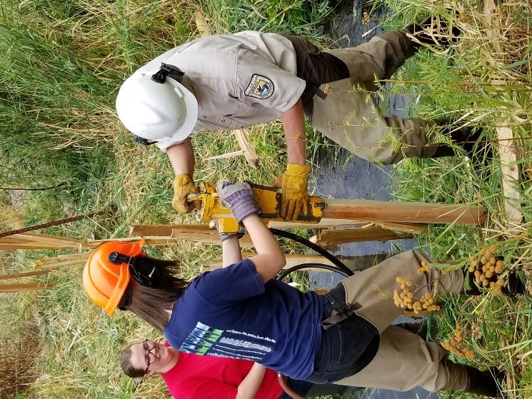
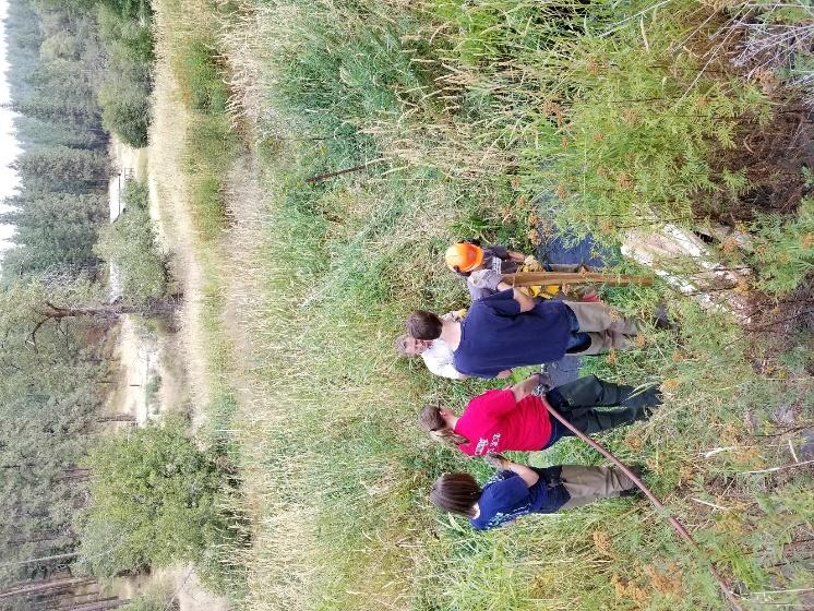
16 New BDA Installation Sept 2017
17 Preliminary Conclusions and Lessons Learned Hypothesis Testing: BDAs maybe trapping sediment behind their structure Preliminary estimates cu.meters/year (rough estimate, more data needed) BDAs raise ground water levels and store water longer Observational evidence only of this over first year (more data needed) Lessons Learned Not built wide enough into floodplain and several were flanked significantly Drone footage during floods can help with redesign (location and orientation) Structure is quite stable even under high flows Channel substrate material is important to BDA stability Inexpensive to build and modify, low risk

18 Questions?

19 Monitoring Results Repeat RTK Surveys Comparison of 2016 and 2017 Erosion Deposition Tolerance 0.2 ft


20 Monitoring Results RTK Comparison Avg, Deposition Upstream of BDA (m) Volume of Deposition Upstream of BDA (cu. m)
John Stella, Ph.D. State University of New York, Syracuse Environmental Science and Forestry (SUNY ESF) Key Concepts
 Key Concepts") Beaver Life History, Biology & Habitat Requirements Photo by Michael S. Quinton, National Geographic Society John Stella, Ph.D. State University of New York, Syracuse Environmental Science and Forestry
Beaver Life History, Biology & Habitat Requirements Photo by Michael S. Quinton, National Geographic Society John Stella, Ph.D. State University of New York, Syracuse Environmental Science and Forestry
Background. AEM Tier 2 Worksheet Stream & Floodplain Management. Glossary
 AEM Tier 2 Worksheet Stream & Floodplain Management Glossary Bankfull Stage: The stage at which water starts to flow over the flood plain; the elevation of the water surface at bankfull discharge. (This
Environmental Protection (NJDEP) The Louis Berger Group, Inc.
 The Louis Berger Group, Inc.") Hydraulic Modeling for Preliminary Evaluation of Potential Flooding Impacts for Various Dredging, Capping and Armoring Scenarios of The Lower Passaic River Restoration Abdulai Fofanah, PE, D.WRE, CFM Murat
Hydraulic Modeling for Preliminary Evaluation of Potential Flooding Impacts for Various Dredging, Capping and Armoring Scenarios of The Lower Passaic River Restoration Abdulai Fofanah, PE, D.WRE, CFM Murat
South St. Vrain / Hall Meadows Restoration Planning August 20, 2015
 South St. Vrain / Hall Meadows Restoration Planning August 20, 2015 Agenda Introductions Purpose & Goals of Meeting Planning Area Master Plan Restoration Planning: Cost Estimates, Grants, Scope, Timeline
Functional Uplift Based Stream Assessment & Restoration Design
 Functional Uplift Based Stream Assessment & Restoration Design Darcy K.L. Turner Senior Environmental Scientist, Biohabitats, Inc. (dturner@biohabitats.com) Christopher A. Streb, PE Ecological Engineer,
Oatka Creek Stream Stabilization and Habitat Restoration Project Narrative
 Oatka Creek Stream Stabilization and Habitat Restoration Project Narrative This project was started from a previous Great Lakes Grant to identify concerns in the Oatka and Black Creek watersheds. Through
What Are Environmental (Instream) Flows?
 Flows?") 1 What Are Environmental (Instream) Flows? Sustainable water management requires that both human needs and the needs of aquatic and riparian ecosystems be fulfilled. Dams and diversion of water for municipal
1 What Are Environmental (Instream) Flows? Sustainable water management requires that both human needs and the needs of aquatic and riparian ecosystems be fulfilled. Dams and diversion of water for municipal
Hydrologic and Ecologic Impacts from the CERP Indian River Lagoon South Project
 Hydrologic and Ecologic Impacts from the CERP Indian River Lagoon South Project Dr. Gretchen Ehlinger Senior Biologist US Army Corps of Engineers Jacksonville District November 15, 2016 AWRA Conference
Successful Floodplain Reconnection
 Successful Floodplain Reconnection Design, Implementation, Monitoring and Adaptive Management Upper Truckee River, Lake Tahoe, California Michael Rudd, PE, Charley Miller PE, Virginia Mahacek, Chad Krofta
Re-plumbing Roadside Ditch Networks
 Re-plumbing Roadside Ditch Networks Ditches Improving management to reduce flooding, water pollution, and in-stream erosion and habitat degradation Rebecca Schneider Dept. Natural Resources Cornell University,
COON CREEK WATERSHED DISTRICT PERMIT REVIEW. Spring Lake Park Schools Westwood Middle School st Avenue NE, Spring Lake Park, MN 55432
 PAN 16-112, Westwood Middle School, Page 1 of 6 COON CREEK WATERSHED DISTRICT PERMIT REVIEW MEETING DATE: August 22, 2016 AGENDA NUMBER: 10 FILE NUMBER: 16-112 ITEM: Westwood Middle School RECOMMENDATION:
Project Goals and Scoping
 Prepared for: Boulder County, Colorado Flood Planning & Preliminary Design Services for South St. Vrain Creek Restoration at Hall Ranch and Scoping May 24, 2016 Meeting with General Public In association
Rainfall, runoff and sediment transport in the Napa River watershed: now and a possible future
 Rainfall, runoff and sediment transport in the Napa River watershed: now and a possible future Lester McKee San Francisco Estuary Institute 5/24/2017 1 The importance of the natural water cycle of infiltration
ECOSYSTEMS, WATERSHEDS AND POLLUTION CONTROL REVIEW
 ECOSYSTEMS, WATERSHEDS AND POLLUTION CONTROL REVIEW ECOSYSTEMS: (6 th grade content) How biotic and abiotic factors make an ecosystem: https://www.youtube.com/watch?v=mdlwptkg-vi 1. A/An ecosystem is a
Stream Simulation in Very Low Gradient Channels
 University of Massachusetts - Amherst ScholarWorks@UMass Amherst International Conference on Engineering and Ecohydrology for Fish Passage International Conference on Engineering and Ecohydrology for Fish
Once There Were Beavers: A Stream Flow Restoration Project for the Potomac Headwaters. Cacapon Institute High View, WV
 Once There Were Beavers: A Stream Flow Restoration Project for the Potomac Headwaters Cacapon Institute High View, WV Technical Committee: John Schmidt (USFWS), Ed Kesecker (USDA-NRCS), Pam Edwards (USDA-
Flow Control No Channel Flow Dry Channels Erosion Control Low Channel Flows Shallow Water Sediment Control High Channel Flows [1] Deep Water [2]
![Flow Control No Channel Flow Dry Channels Erosion Control Low Channel Flows Shallow Water Sediment Control High Channel Flows [1] Deep Water [2]](/thumbs/78/76959611.jpg "Flow Control No Channel Flow Dry Channels Erosion Control Low Channel Flows Shallow Water Sediment Control High Channel Flows [1] Deep Water [2]") Geo Logs (coir logs) INSTREAM PRACTICES Flow Control No Channel Flow Dry Channels Erosion Control Low Channel Flows Shallow Water Sediment Control High Channel Flows [1] Deep Water [2] [1] Geo logs can
Geo Logs (coir logs) INSTREAM PRACTICES Flow Control No Channel Flow Dry Channels Erosion Control Low Channel Flows Shallow Water Sediment Control High Channel Flows [1] Deep Water [2] [1] Geo logs can
Types of Hydropower Facilities
 Types of Hydropower Facilities 1 Impoundment Hydropower- uses a dam to store water. Water may be released either to meet changing electricity needs or to maintain a constant water level. 2 Run-of-River
Site Selection and Design for Stream Mitigation
 Site Selection and Design for Stream Mitigation Will Harman, PG Stream Mechanics The Association of State Wetland Managers State/Tribal/Federal Coordination Meeting March 19-21, 2013 NCTC Our Relationship
SECTION 5.4 LOGJAM REMOVAL AND RIVER RESTORATION
 SECTION 5.4 LOGJAM REMOVAL AND RIVER RESTORATION Logjams restrict the flow and conveyance of natural streams and ditches which can cause increased flooding, destruction of property and wildlife habitat,
Department of the Army Permit Application
 Department of the Army Permit Application DA File Number U.S. Army Corps of Engineers Honolulu District Date Received by CEPOH-RO Send Completed Application to: Honolulu District, U.S. Army Corps of Engineers
Erosion and Sediment Control Plan for a Timber Harvesting Operation
 3930-FM-WM0155 Rev. 7/2004 Erosion and Sediment Control Plan for a Timber Harvesting Operation 1. GENERAL INFORMATION A. Location Municipality B. Timber sale area = acres Date County C. Landowner Name
Chehalis Basin Strategy Programmatic SEPA Draft EIS
 Chehalis Basin Strategy Programmatic SEPA Draft EIS History of Flooding I-5 closed in 1990, 1996, 2007, 2009 Five largest flood events occurred since 1986 2 History of Habitat Degradation Harvest has been
Releasing a River. Reading Selection
 Reading Selection Releasing a River It is March 26, 1996. A group of scientists stand at the base of the Glen Canyon Dam on the Colorado River. They are looking at the landscape shaped by the river. Earlier
IAFSM 2010 Annual Conference. City of Rockford Keith Creek Greenway Flood Mitigation Project
 IAFSM 2010 Annual Conference City of Rockford Keith Creek Greenway Flood Mitigation Project March 10, 2010 Introduction Problem Overview 1890 s Building of homes along Keith Creek 1920 s Home construction
ND Detention Project Development Update
 ND Detention Project Development Update Upper Red River Basin Halstad, MN = 8 Upstream Subwatersheds Fargo, ND = 3 Upstream Subwatersheds Halstad, MN Fargo, ND Wild Rice Otter Tail Bois de Sioux Upstream
Tracy Hames unfurls a three foot map
 Washington Program helps restore hydrology, wetlands, cultural resources on Yakama lands Tracy Hames unfurls a three foot map across the hood of his vehicle. Nearby, birds chirp excitedly as they flutter
Plan Rollout Presentation July 31, Michael G. Hahn, P.E., P.H. Chief Environmental Engineer. Southeastern Wisconsin Regional Planning Commission
 Plan Rollout Presentation July 31, 2014 Michael G. Hahn, P.E., P.H. Chief Environmental Engineer Southeastern Wisconsin Regional Planning Commission # 219703 Racine County Flooding Recommendations and
Funding Guidelines State Fiscal Year 2016
 State Fiscal Year 2016 Water Quality Financial Assistance Centennial Clean Water Program Clean Water Act Section 319 Program Stormwater Financial Assistance Program Washington State Water Pollution Control
Duwamish Waterway Self Guided Tour: Turning Basin Number Three and Terminal 105 Aquatic Habitat Restoration Sites
 Duwamish Waterway Self Guided Tour: Turning Basin Number Three and Terminal 105 Aquatic Habitat Restoration Sites Text and illustrations in the following pages include: (1) summary information describing
AP Environmental Science
 2017 AP Environmental Science Sample Student Responses and Scoring Commentary Inside: RR Free Response Question 4 RR Scoring Guideline RR Student Samples RR Scoring Commentary 2017 The College Board. College
EFFECT OF UPSTREAM DEVELOPMENT ON THE CLEAR CREEK AREA
 EFFECT OF UPSTREAM DEVELOPMENT ON THE CLEAR CREEK AREA Technical Memorandum Farming in the Floodplain Project Prepared for May 2017 PCC Farmland Trust Photo credit: Google Earth TABLE OF CONTENTS Page
Wetlands Project Guidance
 HABITAT Wetlands Project Guidance Stakeholder Informed Introduction Wetlands are lands saturated with water permanently or seasonally. Wetlands are typically defined by three characteristics: 1) The area
ODFW AQUATIC INVENTORY PROJECT RESTORATION MONITORING STREAM HABITAT REPORT
 ODFW AQUATIC INVENTORY PROJECT RESTORATION MONITORING STREAM HABITAT REPORT STREAM: GCG: 5-SC SITE ID: 466 BASIN: ROGUE TREATMENT DATE: 2 SURVEY DATE: 7/29/23 SURVEY CREW: USGS MAPS: ECOREGION: REPORT
Application for resource consent Form B Damming and diversion of water
 Application for resource consent Form B Damming and diversion of water Notes Resource use activities must meet all the conditions of any relevant Permitted Activity Rules in the Waikato Regional Plan or
Supplemental Watershed Plan Agreement No. 10 for Neshaminy Creek Watershed Core Creek Dam (PA-620) Bucks County, Pennsylvania
 Bucks County, Pennsylvania") Supplemental Watershed Plan Agreement No. 10 for Neshaminy Creek Watershed Core Creek Dam (PA-620) Bucks County, Pennsylvania Project Authorization USDA's Small Watershed Program is carried out under the
Supplemental Watershed Plan Agreement No. 10 for Neshaminy Creek Watershed Core Creek Dam (PA-620) Bucks County, Pennsylvania Project Authorization USDA's Small Watershed Program is carried out under the
LOWER BOISE RIVER INTERIM FEASIBILITY STUDY
 LOWER BOISE RIVER INTERIM FEASIBILITY STUDY Public Information Meetings June 29, 2010 June 30, 2010 July 1, 2010 US Army Corps of Engineers BUILDING STRONG Agenda Introductions / Meeting Objectives Greg
SW-74 SERENOVA PRESERVE SITES 2, 3, 4, 8 MITIGATION PLAN
 SW-74 SERENOVA PRESERVE SITES 2, 3, 4, 8 MITIGATION PLAN BACKGROUND INFORMATION Project SWIM? Aquatic Control? Exotic Control? Mitigation Bank? Type No No No No Mitigation Restoration and enhancement Type
Water and Watersheds. Data Maps Action
 Water and Watersheds Data Maps Action What is the Wildlife Action Plan? Restore rare wildlife and habitats. Keep common species common. 2015 Revision: Partners in Conservation Science 2015 Revision Data
Floodplain Restoration with Large Wood
 Floodplain Restoration with Large Wood Caitlin Alcott, CE, CFM ASFPM Conference June 21, 2016 Overview: 1. Functions of large wood in rivers and floodplains 2. Human impacts on large wood dynamics 3. Design
Lyon Creek Cedar Way Stormwater Detention Dam Operation and Maintenance Manual
 Lyon Creek Cedar Way Stormwater Detention Dam Operation and Maintenance Manual Prepared by: Mike Shaw Stormwater Program Manager City of Mountlake Terrace January 2010 Section I General Information This
LEGAL AUTHORITY AND JURISDICTIONS
 CALIFORNIA DEPARTMENT OF FISH AND GAME RIPARIAN RESOURCES AND REGULATORS: The DFG Lake and Streambed Alteration 1600 Process LEGAL AUTHORITY AND JURISDICTIONS Serge Glushkoff CENTRAL COAST REGION YOUNTVILLE
Freight Street Development Strategy
 Freight Street Development Strategy Appendix B: Naugatuck River Floodplain Analysis Freight Street Development Strategy DECEMBER 2017 Page B-1 1.0 NAUGATUCK RIVER FLOODPLAIN AT FREIGHT STREET 1.1 Watershed
Habitat Grant Projects Clinton River Watershed
 Habitat Grant Projects Clinton River Watershed L Y N N E S E Y M O U R E N V I R O N M E N T A L E N G I N E E R O F F I C E O F T H E M A C O M B C O U N T Y P U B L I C W O R K S C O M M I S S I O N
Will be modified map from GIS 6/16 EOD
 Middle-Snake-Tamarac Rivers Watershed District Judicial Ditch #19 Watershed Regional Conservation Partnership Program (RCPP) Public Scoping Meeting September 26, 2016 Will be modified map from GIS 6/16
Conservation Practices for Water Quality: Sediment & Nutrient Control. Trap Sediments/Trap Nutrients on the Field. Improve Soil Health.
 Conservation Practices for Water Quality: Sediment & Nutrient Control. Trap Sediments/Trap Nutrients on the Field. Improve Soil Health. Sediment Conservation Cover Cover Crop Critical Area Planting Field
Magino Project Environmental Impact Statement. Technical Support Document Draft Fish Habitat Compensation Plan
 Magino Project Environmental Impact Statement Technical Support Document 20-14 Rev. No. Revision Date Approved 0 Document issued for EIS Table of Contents SECTION 1.0 INTRODUCTION... 1 SECTION 2.0 BACKGROUND...
Preface. MNR # Queen s Printer for Ontario, 2012 ISBN (PRINT) ISBN (PDF)
 ISBN (PDF)") Preface In 2008, the inter-agency Drainage Act & Section 28 Regulations Team (DART) was established by the Ministry of Natural Resources (MNR) and the Ministry of Agriculture, Food and Rural Affairs (OMAFRA)
Preface In 2008, the inter-agency Drainage Act & Section 28 Regulations Team (DART) was established by the Ministry of Natural Resources (MNR) and the Ministry of Agriculture, Food and Rural Affairs (OMAFRA)
Feasibility Report with Integrated Environmental Assessment Rip Rap Landing HREP APPENDIX M MONITORING & ADAPTIVE MANAGEMENT PLAN
 Feasibility Report with Integrated Environmental Assessment APPENDIX M MONITORING & ADAPTIVE MANAGEMENT PLAN Feasibility Report with Integrated Environmental Assessment INTENTIONALLY LEFT BLANK Feasiblity
Avista Dam Relicensing Factsheet Commenting on the Draft License Application
 Avista Dam Relicensing Factsheet Commenting on the Draft License Application Please Note: This is intended for informational purposes only and does not constitute legal advice. The life of every river
Lesson 2-2: Riparian Zones
 2-14 Lesson 2-2: Riparian Zones Time of Lesson: 1 hour Rationale: The purpose of this lesson is to define what a riparian zone is and link its importance for fish and other animals, and humans, and the
Finding Common Ground between Ecosystem Services and Environmental Ecosystems
 Finding Common Ground between Ecosystem Services and Environmental Ecosystems Elizabeth H. Smith, Ph.D. Nicole A. Davis, B.S. Center for Coastal Studies Texas A&M University-Corpus Christi Project funding
Cedar River Watershed Habitat Conservation Plan
 Cedar River Watershed Habitat Conservation Plan Briefing for the WRIA 8 Salmon Recovery Council November 21, 2013 Cyndy Holtz Seattle Public Utilities cyndy.holtz@seattle.gov What is an HCP? Habitat Conservation
PRENTISS CREEK (SUB-E) KENSINGTON PLACE CONCEPT PLAN VILLAGE OF DOWNERS GROVE, ILLINOIS AUGUST, 2011
 KENSINGTON PLACE CONCEPT PLAN VILLAGE OF DOWNERS GROVE, ILLINOIS AUGUST, 2011") PRENTISS CREEK (SUB-E) KENSINGTON PLACE CONCEPT PLAN VILLAGE OF DOWNERS GROVE, ILLINOIS AUGUST, 2011 Submitted to: NATHANIEL HAWK, STAFF ENGINEER VILLAGE OF DOWNERS GROVE 5101 WALNUT AVENUE DOWNERS GROVE,
PRENTISS CREEK (SUB-E) KENSINGTON PLACE CONCEPT PLAN VILLAGE OF DOWNERS GROVE, ILLINOIS AUGUST, 2011 Submitted to: NATHANIEL HAWK, STAFF ENGINEER VILLAGE OF DOWNERS GROVE 5101 WALNUT AVENUE DOWNERS GROVE,
Headwater Wetland Restoration Techniques The Wetland Drain Restoration Project
 Headwater Wetland Restoration Techniques The Wetland Drain Restoration Project Tools for Managing Small Drainage Features in Rural Landscapes Workshop, March 5, 2014 Dave Richards, Partnership Specialist,
Recommended Resources: The following resources may be useful in teaching this lesson:
 Unit E: Basic Principles of Soil Science Lesson 7: Understanding Soil Erosion and Management Practices Student Learning Objectives: Instruction in this lesson should result in students achieving the following
STREAMBANK RESTORATION DESIGN
 STREAMBANK RESTORATION DESIGN WITH VINYL SHEET PILE GRADE CONTROL STRUCTURES BRUCE M. PHILLIPS, M.S., P.E. ABSTRACT Grade control structures are an effective channel stabilization measure which can eliminate
Lower San Joaquin River Feasibility Study PLAN FORMULATION ADDENDUM
 PLAN FORMULATION ADDENDUM Non-Structural Measure Descriptions Elevate Critical Infrastructure This measure would raise at-risk critical structures above the design inundation level. Elevation would be
What to Expect When You re Expecting A LOMR. Mark Seidelmann, PE, GISP ASFPM 2015, Atlanta Georgia
 What to Expect When You re Expecting A LOMR Mark Seidelmann, PE, GISP ASFPM 2015, Atlanta Georgia Thursday, June 4 th, 2015 Agenda 1 Why File a Letter Of Map Revision (LOMR)? 2 Basic Requirements and Common
Instream Flow Study for the Proposed Lower Bois d Arc Creek Reservoir, Texas
 450,000 400,000 350,000 300,000 250,000 200,000 150,000 Instream Flow Study for the Proposed Lower Bois d Arc Creek Reservoir, Texas 100,000 50,000 0 Jan-48 Jan-51 Jan-54 Jan-57 Jan-60 Jan-63 Jan-66 Jan-69
WATERSHED. Maitland Valley. Report Card 201
 Maitland Valley WATERSHED Report Card 201 The Maitland Valley Conservation Authority has prepared this report card as a summary on the state of our forests, wetlands, surface water, and ground water resources.
John H. Kerr Dam and Reservoir Virginia and North Carolina (Section 216)
") John H. Kerr Dam and Reservoir Virginia and North Carolina (Section 216) Wilmington District, Corps of Engineers Stakeholder Update Presentation January 24, 2014 Authorized under Section 216 of Public
John H. Kerr Dam and Reservoir Virginia and North Carolina (Section 216) Wilmington District, Corps of Engineers Stakeholder Update Presentation January 24, 2014 Authorized under Section 216 of Public
June 22, Francis E. Borcalli, P.E.
 CACHE CREEK SETTLING BASIN SYMPOSIUM Managing the Settling Basin Who s Doing What! June 22, 2009 Francis E. Borcalli, P.E. CACHE CREEK SETTLING BASIN SYMPOSIUM Managing the Settling Basin Who s Doing What!
Monitoring Stormwater Best Management Practices: Why Is It Important and What To Monitor
 Monitoring Stormwater Best Management Practices: Why Is It Important and What To Monitor Scott D. Struck, Ph.D. US EPA, Urban Watershed Management Branch New Jersey Water Monitoring Workshop 4/20/2006
FISH HABITAT RESTORATION DESIGNS FOR CAVE CREEK, WITHIN THE NAHWITTI RIVER WATERSHED
 FISH HABITAT RESTORATION DESIGNS FOR CAVE CREEK, WITHIN THE NAHWITTI RIVER WATERSHED Prepared for: Tom Cole, RPF Richmond Plywood Corporation 13911 Vulcan Way Richmond, B.C. V6V 1K7 March 2004 Prepared
Unit E: Basic Principles of Soil Science. Lesson 7: Understanding Soil Erosion and Management Practices
 Unit E: Basic Principles of Soil Science Lesson 7: Understanding Soil Erosion and Management Practices 1 Important Terms Accelerated erosion Conservation tillage Cover crops Diversion ditches Geologic
Analysis of Floodplain Fish Habitat on the San Joaquin for the San Joaquin River Restoration Project (SJRRP)
") Analysis of Floodplain Fish Habitat on the San Joaquin for the San Joaquin River Restoration Project (SJRRP) Daniel Dombroski (ddombroski@usbr.gov), Blair Greimann, Elaina Gordon, Katrina Harrison (Reclamation)
Analysis of Floodplain Fish Habitat on the San Joaquin for the San Joaquin River Restoration Project (SJRRP) Daniel Dombroski (ddombroski@usbr.gov), Blair Greimann, Elaina Gordon, Katrina Harrison (Reclamation)
ALABAMA S BEST MANAGEMENT PRACTICES. Protection of Water Quality During Timber Harvesting
 ALABAMA S BEST MANAGEMENT PRACTICES Protection of Water Quality During Timber Harvesting Water Quality Responsibility Landowners and/or involved professional forestry practitioners such as: Forest resource
Lecture 1 Integrated water resources management and wetlands
 Wetlands and Poverty Reduction Project (WPRP) Training module on Wetlands and Water Resources Management Lecture 1 Integrated water resources management and wetlands 1 Water resources and use The hydrological
CHAPTER 7. San Dieguito River Flooding Adaptation
 CHAPTER 7 San Dieguito River Flooding Adaptation This chapter includes a range of adaptation measures to address vulnerabilities from flooding along the San Dieguito River, including the river valley,
Chehalis Basin Strategy Causes of Extreme Flooding. October 11, 2016 Policy Workshop
 Chehalis Basin Strategy Causes of Extreme Flooding October 11, 2016 Policy Workshop Agenda Hydrology o Precipitation o Flow Climate Change Effects Land Use o Channel straightening and incision o Riparian
C O M P R E H E N S I V E P R O T E C T I O N & R E S T O R AT I O N P L A N. f or th e
 C O M P R E H E N S I V E P R O T E C T I O N & R E S T O R AT I O N P L A N f or th e R O S S B A R NE T T R E SERV O I R WATERS HED, MI S S I S S I P P I E X E C U T I V E S U M M A R Y O C T O B E R
Methods of Streamflow Analysis
 4 Methods of Streamflow Analysis CHAPTER 4 Streamflow Measurements Danielle M. Andrews Department of Crop and Soil Sciences, The Pennsylvania State University I. INTRODUCTION Perennial carries water all
USING HYDROSCAPES TO MAXIMIZE THE BENEFITS OF RIPARIAN CORRIDOR RESTORATION FOR MULTIPLE RIVER ECOSYSTEM SERVICES
 REFORM International Conference on River and Stream Restoration Novel Approaches to Assess and Rehabilitate Modified Rivers TEMPLATE FOR EXTENDED SUMMARY USING HYDROSCAPES TO MAXIMIZE THE BENEFITS OF RIPARIAN
Informational Meeting- March 31, Boxelder B-2/B-3 Watershed Planning Study
 Informational Meeting- March 31, 2016 Boxelder B-2/B-3 Watershed Planning Study Agenda Introductions Work Completed to Date Phase 1 Evaluations Alternatives Evaluations Economic Evaluations Draft Watershed
Environmental Flow Regimes. Joe Trungale s presentation to the Science Advisory Committee March 4, 2009
 Overlays to Hydrology-Based Environmental Flow Regimes Joe Trungale s presentation to the Science Advisory Committee March 4, 2009 Overlays - Definition Application of analysis to validate or refine flow
Stream Corridor Protection and Adaptive Management Manual. Prepared for the City of Independence, Missouri
 Stream Corridor Protection and Adaptive Management Manual Prepared for the City of Independence, Missouri Rock Creek Independence, Missouri By Patti Banks Associates and Applied Ecological Services, Inc.
How can rivers be managed?
 How can rivers be managed? To be able to identify different management strategies, distinguishing between hard and soft engineering (4-5) To be able to give the advantages and disadvantages of different
Stream Reaches and Hydrologic Units
 Chapter United States 6 Department of Agriculture Natural Resources Conservation Service Chapter 6 Stream Reaches and Hydrologic Units Rain clouds Cloud formation Precipitation Surface runoff Evaporation
General Instream Flow Methods Overview. Agency Meeting on 2012 Draft Study Descriptions January 24, 2011
 General Instream Flow Methods Overview Agency Meeting on 2012 Draft Study Descriptions January 24, 2011 1 Susitna River 2 Main Channel and Side Channels 3 Sloughs and Side Channels 4 Turbidity Portage
Flow-ecology relationships. Flow-ecology relationships Susitna case study
 Flow-ecology relationships Flow-ecology relationships Susitna case study Flow regime Ecologically-Relevant Flow Regime Characteristics Seasonal or typical conditions Annual extreme conditions High and
Geneva Dam. Design of a Steep, Temporary, Riprap Ramp
 Geneva Dam Design of a Steep, Temporary, Riprap Ramp A Run-of of-river Dam Analysis for Geneva Dam Credit to: Yu-Chun Su, Ph.D., P.E., CFM David T. Williams. Ph.D., P.E, CFM Presentation Purpose History
Instream Flows in the San Antonio River Basin From Science to Environmental flow Standards. Steven J. Raabe, P.E
 Instream Flows in the San Antonio River Basin From Science to Environmental flow Standards Steven J. Raabe, P.E October 26, 2012 Keys to Success Mandated Processes Science Compatible Schedules Stakeholder
OKANAGAN WATER PROJECTS GET FUNDS TO MOVE AHEAD
 April 17, 2018 FOR IMMEDIATE RELEASE OKANAGAN WATER PROJECTS GET FUNDS TO MOVE AHEAD Kelowna, B.C. The Okanagan Basin Water Board (OBWB) has approved $300,000 in funding to 18 projects to help conserve
Flood Risk Management on the Elwha: Case Study of the Federal Levee Modification Project
 Flood Risk Management on the Elwha: Case Study of the Federal Levee Modification Project US Army Corps of Engineers Zac Corum, PE, Hydraulic Engineer Travis Ball, PE, CFM, Hydraulic Engineer Seattle District
719 Griswold, Suite 820 Detroit, MI DANVERS POND DAM REMOVAL AND STREAM RESTORATION PROJECT
 Great Lakes Restoration Initiative Grant Final Report US EPA Grant GL 00E006 43 October, 2013 Valley Woods Wetland Southfield Lola Valley Grow Zone Wayne County Parks Venoy Park Grow Zone Wayne County
Waterways Local Update
 Waterways Local Update 2016-17 Melbourne Water s work to improve waterways and provide flood protection in the City of Banyule. REDUCED THE RISK OF FLOODING 29.7 km WEED CONTROL ALONG WATERWAYS THREE ENVIRONMENTAL
Rock Creek Floodplain Analysis
 Rock Creek Floodplain Analysis www.co.washington.or.us By Jon Franczyk 1996 Flood, www.co.washington.or.us 1996 Flood, www.co.washington.or.us Project Outline Project Goals Introduction Background Study
Working in Arid and Semi-Arid Climates with Hydromodification Concerns
 Design Techniques for Stream Restoration: Working in Arid and Semi-Arid Climates with Hydromodification Concerns Presented By: Tory R. Walker, PE, CFM, LEED GA September 30, 2014 Brief Overview Short History
Mountain States Chapter International Erosion Control Association Conference
 Mountain States Chapter International Erosion Control Association Conference November 5, 2015 Ian Paton, P.E, CFM Wright Water Engineers, Inc. Eliot Wong P.E., CFM Contech Engineered Solutions Hayes Lenhart,
Prepared for Urban Drainage and Flood Control District
 BERM FAILURE TECHNICAL ANALYSES SOUTH PLATTE GRAVEL PIT EVALUATION CRITERIA Prepared for Urban Drainage and Flood Control District Wright Water Engineers, Inc. January 2013 121-030.000 TABLE OF CONTENTS
Planning and Combination (Planning and Acquisition) Project Proposal
 Project Proposal") Planning and Combination (Planning and Acquisition) Project Proposal Project Number 15-1308 Project Name Asotin County Geomorphic/Watershed Assessment Sponsor Asotin County Conservation District List all
Planning and Combination (Planning and Acquisition) Project Proposal Project Number 15-1308 Project Name Asotin County Geomorphic/Watershed Assessment Sponsor Asotin County Conservation District List all
18 Little White Salmon Subbasin
 18 Little White Salmon Subbasin Figure 18-1. Location of the Little White Salmon River Subbasin within the Lower Columbia River Basin. 18.1 Basin Overview The Little White Salmon Subbasin encompasses approximately
FACTSHEET INTRODUCTION. help rebalance the water cycle, mitigate the effects of climate change and improve human health and livelihoods.
 1 FACTSHEET INTRODUCTION World Water Day, on 22 March every year, is about focusing attention on the importance of water. This year s theme, Nature for Water, explores nature-based solutions (NBS) to the
Ch 18. Hydrologic Cycle and streams. Tom Bean
 Ch 18. Hydrologic Cycle and streams Tom Bean Wednesday s outline 1. the hydrologic cycle reservoirs cycling between them Evaporation and the atmosphere 2. Surface hydrology infiltration and soil moisture
Clearwater River Stream Bank Stabilization and Revitalization Project
 Clearwater River Stream Bank Stabilization and Revitalization Project In 2001 the RLWD continued work on the Clearwater River Stream Bank Stabilization and Revitalization Project. The work performed during
STREAM RESTORATION PURPOSE, PRACTICE, AND METHODS. By Marcus Rubenstein, CPESC
 STREAM RESTORATION PURPOSE, PRACTICE, AND METHODS By Marcus Rubenstein, CPESC WHAT IS STREAM RESTORATION? The return of a stream s lost natural functions, usually resulting from watershed alterations,
Interstate-Callahan Upper and Lower Rock Dumps RA Construction Project. East Fork Ninemile Creek, Idaho May 3, 2016
 Interstate-Callahan Upper and Lower Rock Dumps RA Construction Project East Fork Ninemile Creek, Idaho May 3, 2016 Tony Wesche, P.E. Pioneer Technical Services, Inc. and North Wind Group Presentation Topics
Drop Height For Channel Erosion Control
 Drop Height For Channel Erosion Control James C.Y. Guo, Professor and Director Department of Civil Engineering, U. of Colorado at Denver, Denver, Colorado 8017 E-mail: James.Guo@cudenver.edu Introduction
FieldDoc.org User Guide For 2017 NFWF Chesapeake Bay Stewardship Fund Applicants. Background 2. Step 1: Register for a FieldDoc account 3
 FieldDoc.org User Guide For 2017 NFWF Chesapeake Bay Stewardship Fund Applicants Table of Contents (click to go to page) Background 2 Step 1: Register for a FieldDoc account 3 Step 2: Create the Project