Greene Township Municipal Authority Act 537 Plan Update Amendment
|
|
|
- Nathan Phillips
- 6 years ago
- Views:
Transcription


1 Submitted to: Greene Township Municipal Authority Act 537 Plan Update Amendment Submitted by: March 2013

2 Greene Township Municipal Authority Franklin County, Pennsylvania Act 537 Plan Update Amendment March 2013
3 Greene Township Municipal Authority Act 537 Plan Update - Amendment March Contents Section Title Page 1.0 INTRODUCTION EXISTING CONDITIONS POPULATION PROJECTIONS AND FUTURE FLOWS PHASED IMPROVEMENTS APPROACH PHASE II - INFLOW AND INFILTRATION PROGRAM Conveyance Facilities Comprehensive Sewer System Evaluation Survey Approach Background Findings/Recommendation Phase III Planning and Preparation EVALUATION OF ALTERNATIVES Consistency Analysis Comprehensive Water Quality Management Plan Municipal Wasteload Management Plans Title II of the Clean Water Act Comprehensive Planning Chapter 93, 95, and 102 Anti-degradation Requirements State Water Plan Prime Agricultural Land Policy County Stormwater Management Plans Wetlands Pennsylvania Natural Diversity Inventory Historical and Archeological Resource Protections Water Quality Standards and Effluent Limitations Resolution of Inconsistencies Phase I Alternative Evaluation FUNDING METHODS CONCLUSIONS...29 i
4 Greene Township Municipal Authority Act 537 Plan Update - Amendment March Tables Table Title Page 2-1 Green Township Municipal Authority Existing System Data Greene Township Municipal Authority Planning Projections Phase I Alternatives for Evaluation Basin Prioritization Phased Sewer System Evaluation Survey Priority Basins Rain Derived Inflow and Infiltration Reduction Program Schedule and Costs Phase I Alternatives Advantages and Disadvantages Phase I Alternatives Estimated Construction Cost Implementation Schedule...30 Figures Figure Title Page 4-1 Phase I Alternative Proposed Conveyance Route Sewer System Evaluation Survey Program Flowchart...10 Appendices Appendix Title A B C D E F G H 2013 Sewer System Model Enhancement and Capacity Evaluation Report 2013 Capacity Evaluation Exhibits Pennsylvania Natural Diversity Index Project Environmental Reviews Pennsylvania Natural Diversity Index Inquiries Pennsylvania Natural Diversity Index Responses Pennsylvania Historical Museum Commission Cultural Resource Inquiry Pennsylvania Historical Museum Commission Letter Planning Level Opinion of Probable Costs ii
5 Greene Township Municipal Authority Act 537 Plan Update - Amendment March INTRODUCTION The Greene Township Municipal Authority (GTMA) was incorporated by the Supervisors of Greene Township, Franklin County, Pennsylvania, to provide wastewater collection and conveyance service to most Greene Township residents. The GTMA also provides service to a small portion of neighboring Guilford Township. All of the GTMA Sewer System is tributary to the Chambersburg Borough conveyance system and Wastewater Treatment Plant (WWTP). The GTMA submitted an Act 537 Plan Update to the Pennsylvania Department of Environmental Protection (PADEP) in December 2008 to serve as the Official Sewage Facilities Plan of Greene Township. PADEP provided comments on the submission in a September 3, 2009 letter addressed to the Greene Township Supervisors, Act 537 Planning APS ID No DEP Code No. G ACT deficiencies letter (2009 PADEP Letter). The 2009 PADEP Letter contained four (4) review comments, chief among them was the failure of the Plan Update to provide for the resolution of existing sewage facility problems and the failure of the Plan Update to provide for the future disposal needs of Greene Township. GTMA s February 2009 Wasteload Management Report (Chapter 94 Report) had identified a hydraulic overload within the GTMA sewer system that was not adequately addressed by the December 2008 Plan Update. In response to the hydraulic overload, GTMA prepared a Corrective Action Plan (CAP) in July 2009 to address the overload. The CAP included several broad action items, including preparation of an amendment to the adopted, December 2008 Act 537 Plan Update. In October 2009, the PADEP approved the CAP. The CAP was updated in June GTMA reported overflows from its Fayetteville interceptor as a result of wet weather events in early In April 2010, PADEP established a connection prohibition for facilities tributary to the Fayetteville interceptor. GTMA entered into a Consent Order and Agreement (COA) with PADEP in August The COA called for GTMA to undertake a comprehensive Inflow and Infiltration Plan to identify sources of extraneous flow and to undertake the necessary improvements to eliminate overflows. 1
6 Greene Township Municipal Authority Act 537 Plan Update - Amendment March This Act 537 Plan Update Amendment was undertaken to address the comments in the 2009 PADEP Letter and to develop, evaluate, and select an approach to ultimately eliminate sanitary sewer overflows (SSOs) and provide adequate capacity to provide for future disposal needs of Greene Township. 2.0 EXISTING CONDITIONS The GTMA sewer system consists of approximately 13.7 miles of interceptor that conveys the wastewater from Greene Township residents, some of Guilford Township residents, and the wastewater generated at the Chambersburg Water Treatment Plant to the Chambersburg Borough conveyance system. The GTMA sewer system has approximately 110 miles of collection sewers, 4.8 miles of force main pressure pipes, and eleven (11) lift stations. Table 2-1 provides additional GTMA system and population information. TABLE 2-1 GREENE TOWNSHIP MUNICIPAL AUTHORITY EXISTING SYSTEM DATA Description Existing Data 2010 Population (1) 16,700 Equivalent Dwelling Units (2) 7,300 Average Dry Weather Flow (3) 2.6 mgd Sewer Interceptor Length (4) 13.7 miles Notes: (1) 2010 Population taken from Census Data reported to Pennsylvania State Data Center. (2) Equivalent Dwelling Units taken from Greene Township Chapter 94 Report for (3) Average Dry Weather Flow (ADWF) taken from 2013 Capacity and Evaluation Report, Table 1, measured in million gallons per day (mgd). (4) Length of interceptor in GTMA estimated from mapping and modeling data and information. As part of the 2013 GTMA Sewer System Model Enhancement and Capacity Evaluation (2013 Capacity Evaluation), GTMA s sewer system was studied to determine the hydraulic capacity of the existing interceptor with current flows based on flow metering data collected during 2011 and estimated future flows. The 2013 Capacity Evaluation report is provided in Appendix A. The results of the 2013 Capacity Evaluation provided a means to identify short-term and long-term improvement needs for the GTMA interceptor. The existing interceptor in Fayetteville and portions of Oak Hill are undersized to adequately convey the peak flows monitored during specific storm events during As a result, SSOs have been reported 2
7 Greene Township Municipal Authority Act 537 Plan Update - Amendment March in the Fayetteville Basin while the system is experiencing peak flows. In addition, flow monitoring at the Penn Hall meter, located directly upstream of GTMA s connection to the Chambersburg sewer system, have recorded flows at or near 0.0 million gallons per day (mgd) during storm events. Based on the Penn Hall meter calibration and cleaning records, this zero flow reading could be potentially due to Chambersburg sewer system back-ups into the GTMA sewer system that require additional investigation. Additional information on the 2011 flow metering is provided in The 2013 Capacity Evaluation report in Appendix A. 3.0 POPULATION PROJECTIONS AND FUTURE FLOWS Based on long-term projections available from the Pennsylvania State Data Center, the Franklin County population is projected to increase from 129,313 in 2000, according to the 2000 Census, to 148,596 in However, the 2010 Franklin County Census counted 149,618 people, which was more than the most recent Pennsylvania State Data Center projections for The Franklin County Planning Commission was contacted for available population projections for Greene Township over the next 20 years and to resolve this apparent discrepancy. The Planning Commission indicated it is currently in the process of developing new population projections. Given the lack of available data, 20-year population projections developed by GTMA staff were used for this Plan Update. The GTMA population projections were based on current Greene Township zoning, available undeveloped land, and the historical rate of new growth within Greene Township before the national slow-down in housing development in The Flow Projections Section of the 2011 GTMA Chapter 94 Report included both population projections and wastewater flow projections. The Report projects 80 new equivalent dwelling units (EDUs) will be added within Greene Township per year over the next 5 years. In addition to these 400 new EDUs, GTMA staff expects another 1,600 new EDUs to be added to the sewer system in years 6 through 20, resulting in a total increase of 2,000 EDUs for the next 20 years. Based on a planning estimate of 225 gallons per day (gpd) per EDU, the additional 2,000 EDUs that are expected over the next 20 years will contribute an additional average flow of 0.45 mgd. A peaking factor of 2.0 was applied to the average flow for consideration of peak 3
8 Greene Township Municipal Authority Act 537 Plan Update - Amendment March flow sewer pipe design. The new sewers serving the new EDUs are not expected to contribute as much inflow or infiltration as the existing aging infrastructure, since the new sewers and connections will be made in accordance with GTMA s specifications, will be air tested during construction, and construction will be overseen by GTMA inspectors. The peak flow from the 20-year additional population is expected to be approximately 0.90 mgd. A summary of the projected flows and EDUs is provided in Table 3-1. TABLE 3-1 GREENE TOWNSHIP MUNICIPAL AUTHORITY PLANNING PROJECTIONS Description Existing 5 Year Growth Years 5, 20 Growth Estimated 2030 Population (1) 16, ,840 21,500 Equivalent Dwelling Units (2) 7, ,600 9,300 Average Dry Weather Flow (3) 2.6 mgd 0.09 mgd 0.36 mgd 3.05 mgd Peak Flow (4) 8.5 mgd 0.18 mgd 0.72 mgd 9.4 mgd Notes: (1) Existing population counted from 2010 census data from the Pennsylvania State Data Center. Projected population estimated from GTMA projected new EDUs at 2.4 people per EDU. (2) Existing Equivalent Dwelling Units developed by GTMA staff for Chapter 94 Report and the Act 537 Plan Update Amendment. (3) Existing ADWF taken from dry weather days in 2011 flow metering data as described in the 2013 Capacity Evaluation Report. Projected ADWF estimated at 225 gpd/edu. See Section 3 for justification. (4) Existing peak flow taken from 2011 flow metering data during peak storm events as described in the 2013 Capacity Evaluation Report. Projected peak flows estimated from projected ADWF with a 2.0 peaking factor. 4.0 PHASED IMPROVEMENTS APPROACH GTMA experienced overflows from its Fayetteville interceptor in early As a result of the overflows and as a condition of the subsequent CAP, GTMA completed an interceptor capacity evaluation and needs assessment, as explained in the 2013 Capacity Evaluation, in Appendix A. The 2013 Capacity Evaluation report identified short-term and long-term improvement needs for the GTMA interceptor. The 2013 Capacity Evaluation report also identified potential problems within the downstream Chambersburg system, which could cause backups within the GTMA sewer system. These backups rendered the GTMA flow metering ineffective in quantifying the magnitude of peak flows in the lower reaches of the GTMA sewer 4
9 Greene Township Municipal Authority Act 537 Plan Update - Amendment March system. Due to the extent and cost of capital improvements identified in the Capacity Evaluation report and the unknowns related to Chambersburg backups and GTMA peak flows, a three-phased improvement concept has been identified to meet the current and long-term system needs. The phased concept includes short-term interceptor improvements to address known capacity needs in the Fayetteville Basin and long-term measures to reduce inflow and infiltration (I&I) and address capacity issues in other portions of the system, for which the extent of improvement needs cannot be defined at this time, as described in the 2013 Capacity Evaluation report. Phase I involves increasing the capacity of the undersized interceptor in the Fayetteville and the Oak Hill Basins. Figure 4-1 shows the tentative route for Phase I improvements. Phase I improvements will help to mediate the peak flow issues in the Fayetteville area of the GTMA sewer system; however, according to modeling analyses, Phase I improvements are not expected to impact the flows Chambersburg is receiving from GTMA, due to the constrained flows in Chambersburg interceptor and the downstream GTMA basins. Phase II will include investigation of the capacity in the Chambersburg interceptor and based on the findings of the investigation, improvements may be necessary upstream or downstream of the Penn Hall meter. 5
 Phase II is a program to further identify system deficiencies including:")

10 Greene Township Municipal Authority Act 537 Plan Update - Amendment March FIGURE 4-1 PHASE I ALTERNATIVE PROPOSED CONVEYANCE ROUTE (Red Segment to be Replaced or Paralleled) Phase II is a program to further identify system deficiencies including: better assessment of peak flows in the system; investigation of downstream capacity in the Chambersburg system available for GTMA flows; and more detailed investigation of sources of I&I and rehabilitation of identified sources to reduce I&I. Phase III involves undertaking the necessary improvements beyond those completed in Phase I and II, to address the long-term capacity needs in the GTMA interceptor, and addressing the Chambersburg interceptor capacity if necessary. 6
11 Greene Township Municipal Authority Act 537 Plan Update - Amendment March As part of the 2013 Capacity Evaluation, the Authority s sewer system was studied to determine the hydraulic capacity of the existing interceptor with current and future flows. The existing interceptor in Fayetteville and portions of Oak Hill are undersized to adequately convey the peak flows monitored during specific storm events during Therefore, two (2) Phase I alternatives were developed to alleviate the peak flow capacity inadequacies. Alternative 1 involves replacing approximately 2.5 miles of the existing interceptor in portions of Fayetteville and Oak Hill with 24-inch diameter sewer. The larger sewer would be placed in the same trench as the existing interceptor. Alternative 2 rehabilitates the existing interceptor with new manholes and runs a parallel sewer along the existing interceptor. The parallel sewer would add approximately 2.5 miles of 12- and 18-inch diameter main adjacent to the existing interceptor in portions of Fayetteville and Oak Hill. Other Alternatives were considered, but eliminated to address the existing and projected future needs. These other alternatives included flow equalization, pumping excess peak flows to a point lower in the GTMA system, and system rehabilitation to reduce peak flows. The rehabilitation option was eliminated from consideration since the existing Fayetteville interceptor was determined to be undersized to convey future flows even with significant I & I reduction. Table 4-1 summarizes the two technically feasible Phase I alternatives to increase the capacity of the undersized interceptor in Fayetteville and Oak Hill Basins. 7
12 Greene Township Municipal Authority Act 537 Plan Update - Amendment March TABLE 4-1 PHASE I ALTERNATIVES FOR EVALUATION (1) No. Fayetteville Interceptor Alternative Required Conveyance Improvement 1 2 Replace Existing Portions of Interceptor in Fayetteville and Oak Hill Basins Install a parallel sewer along portions of the Fayetteville and Oak Hill interceptors Notes: (1) Estimate of probable cost for each alternative is provided in Chapter 6.2. Install approximately 12,750 linear feet of 24- inch interceptor Replace existing manholes with new manholes Install approximately 6,650 feet of 12-inch parallel sewer Install approximately 5,900 feet of 18-inch parallel sewer Install approximately 10 feet of connecting sewers to the existing interceptor Replace the manholes on the existing interceptor with new manholes 5.0 PHASE II INFLOW AND INFILTRATION PROGRAM Phase II is a program to identify system deficiencies including, better assessment of peak flows in the system, investigation of downstream capacity in the Chambersburg system available for GTMA flows, and more detailed investigation of sources of I&I and rehabilitation of identified sources to reduce I&I. This phase will be used to assess the results of the Phase I improvements and help quantify peak flows associated with the downstream GTMA sewer basins that could not be determined to date due to potential backflows from the Chambersburg interceptor. Field investigations as part of Phase II will commence during the Phase I construction period. GTMA will continue to monitor flows with their existing meters, and incorporate a digital rain gage to understand the hydrological contributors. The details of the I&I program associated with Phase II are described below. 5.1 Conveyance Facilities As discussed throughout the 2013 Capacity Evaluation (Appendix A) and this Plan Update Amendment, the GTMA collection and conveyance system is impacted by wet weather flows resulting in hydraulic overload conditions. GTMA s Inter-municipal Agreement (IMA) 8
13 Greene Township Municipal Authority Act 537 Plan Update - Amendment March with Chambersburg Borough permits an annual flow of 1.84 mgd. The average annual flow during the period from 2009 to 2010 was 2.3 mgd. The cumulative ADWF for the system was estimated to be 2.6 mgd, based upon the 2011 flow monitoring period. Peak flows during the monitoring period were greater than 8.5 mgd. This indicates portions of the collection systems capture excessive amounts of I&I, further reinforced by the flow metering, model development and analysis, and the capacity evaluation. Recapturing a portion of this capacity through sewer system rehabilitation is typically a cost-effective wastewater conveyance alternative. As detailed herein, a systematic approach for prioritization of rehabilitation of existing sewer sections will be implemented through a comprehensive multi-year Sewer System Evaluation Survey (SSES) program Comprehensive Sewer System Evaluation Survey Approach As part of this Plan Update Amendment, GTMA will implement a multi-year SSES Program. Within the first 5 years following Phase I completion, high priority sewersheds will be addressed. Lower priority sewersheds will be addressed in subsequent years. The main objective is to identify sources of I&I and determine the most cost-effective approach to address reduction of this extraneous flow, which essentially uses system capacity that could otherwise be used for conveyance and treatment of wastewater from new system users. Recapturing a portion of this capacity can be the most cost-effective wastewater conveyance alternative. Rehabilitation of existing sewer sections will be implemented through the SSES program according to the established priority framework provided in the 2013 Capacity Evaluation Report. The rehabilitation will be performed to address National Association of Sewer Service Companies (NASSCO) -coded defects of the highest priority. The SSES will be completed in accordance with the Environmental Protection Agency (EPA) Handbook "Sewer System Infrastructure Analysis and Rehabilitation Handbook" (EPA/ /030, 1991). The methods identified in the EPA Handbook prescribed a multi-phased approach, generally involving: (1) analysis, (2) evaluation, and (3) rehabilitation. Figure 5-1 outlines a thorough SSES program. 9
14 Greene Township Municipal Authority Act 537 Plan Update - Amendment March FIGURE 5-1 SEWER SYSTEM EVALUATION SURVEY PROGRAM FLOWCHART Review Existing Data Develop Project Approach Groundwater Monitoring Flow Monitoring Rainfall Monitoring Infiltration Inflow Night Flow Isolation Manhole Physical Inspection Smoke Testing Television/ Inspection Analysis Cost/Benefit Analysis Dye Testing Rehabilitation Recommendations Background The Authority has been performing sewer system investigation and repair since The program was intensified during the past 5 years, and the GTMA reports it has spent $2.4 million on inspection equipment, flow meters, and sewer system rehabilitation during this time. Based upon the historical analyses and documentation, GTMA staff believes that system issues still exist in the drainage basins east of Interstate 81. Recent flow monitoring and the 2013 Capacity Evaluation support this conclusion. 10
15 Greene Township Municipal Authority Act 537 Plan Update - Amendment March Other tasks performed by GTMA include: Development of comprehensive sewer system mapping, using an electronic Geographic Information System (GIS) database. Operation and Maintenance (O&M) activities: cleared/grubbed 4.5 miles of previously neglected easement and performed internal closed-circuit television (CCTV) inspection of 12 miles of interceptor. Acquisition of flow meters and implementation of a flow monitoring program (16 selected sites). Development of a computer model of the Authority s collection/conveyance system, utilizing Bentley s SewerGEMS software (with the existing GIS data, and recorded flow metering data). Completed a hydraulic capacity analysis of the interceptor system utilizing the hydraulic model. Initiated planning of hydraulic improvements to the interceptor system Findings/Recommendation In accordance with the CAP, the GTMA has 16 metering locations throughout the system, some installed as early as Utilizing this broad flow monitoring program, and the Comprehensive I&I Plan mandated by the COA, GTMA has expressed a commitment to thoroughly assess and rehabilitate their collection/conveyance system. Through flow analyses and hydraulic modeling, the sewersheds were prioritized, as described in the 2013 Capacity Evaluation. The metered basins were compared and prioritized based on peak flows experienced during a November 2011 storm event. For the purpose of calculating ADWF for use in the model, each meter site was evaluated based on the data for days with no precipitation and no precipitation in the previous 2 days. After calculating the ADWF for each meter, a flow balance of all the meters was developed and analyzed. The ADWF and peak flow per EDU in each basin or sub-basin contributing flow to each meter was also reviewed 11
16 Greene Township Municipal Authority Act 537 Plan Update - Amendment March to further assess the validity of the meter data for use in setting model inflows. ADWF and peak flow per linear computation (linear feet or inch-mile) were also analyzed. Table 5-1 shows the prioritization for each metered basin. First Priority Basins: include Oak Hill Basin (Manhole 503), Mount Pleasant Road Sub-Basin (Manhole 139), Newman Road Sub-Basin (Manhole 99), and Trayer Howe Sub-Basin (Manhole 248) in Fayetteville, and Black Gap Road Sub-Basin (Manhole 35) in Greene Knolls. The First Priority Basins will be the initial focus of the comprehensive SSES. The Second Priority Basins include: Hidden Valley Sub-Basin (Manhole 200) in Fayetteville, and sub-basin contributing to Manhole 672 in the Central Basin. 12
17 Greene Township Municipal Authority Act 537 Plan Update - Amendment March TABLE 5-1 BASIN PRIORITIZATION Red First Priority Yellow Second Priority Primary Basin Greene Knolls Manhole ID EDUs Linear Feet (LF) 11/23/11 Metered Peak Flow (mgd) 11/23/11 Metered Peak Sewer Capacity (gpd/ LF) (gpd/ inchmile gpd/ EDU , ,478 7, , ,000 1, , ,653 1,720 ADWF (mgd) Cumulative Average Dry Weather Flow Sewer Capacity (gpd/ LF) (gpd/ inchmile gpd/ EDU , , ,136 6, ,553 1, , ,784 2, , Fayetteville , ,216 7, ,136 2, , ,891 16, , , ,727 7, , , ,441 1, , Oak Hill , ,351 25, ,565 2,959 Central (1) , ,276 3, , S. Scotland (2) , , , N. Scotland , , , Greenvillage 1049A , , Red Bridge (3)(4) , , , Siloam (3)(4) MC , ,971-1, Notes: (1) Central Basin accepts flow from Guilford Township which ranges from 0.18 to 0.42 mgd. (2) Missing flow metering data for South Scotland Basin during the November 23, 2011 Storm. Metered Peak Flow reported from May 26, 2011 Storm Event. Flow metering data recorded less than upstream flow meter during peak (5/26/2011) and ADWF. Scaled downstream meter average dry weather flow used. (3) Red Bridge and Siloam dry weather flow metering data was less than upstream metering data. Adjusted Red Bridge and Siloam data to 20% of Siloam meter reading for ADWF, and scaled Red Bridge. (4) Table includes length of main in basins that contribute to metering data only. Due to its location, the Penn Hall meter in Siloam includes some main in Red Bridge. The SSES will initially target televising the sewer mains in the First Priority Basins. Structural and O&M deficiencies will be scrutinized during the field inspections. Concurrent manhole inspections will be performed during the CCTV operations. Defects identified will be categorized using the universally-recognized defect coding system developed by the NASSCO. 13
18 Greene Township Municipal Authority Act 537 Plan Update - Amendment March Guidelines of the NASSCO Pipeline Assessment and Certification Program (PACP) and the Manholes Assessment and Certification Program (MACP) will be followed. Flow isolation and smoke testing field investigations will also be utilized as warranted. Second Priority Basins will be addressed after completion of the First Priority Basins. Other basins will be reassessed during subsequent years. Table 5-2 summarizes the sizes of the priority basins TABLE 5-2 PHASED SEWER SYSTEM EVALUATION SURVEY PRIORITY BASINS Primary Basin Manhole ID EDUs Linear Feet (LF) FIRST PRIORITY Greene Knolls ,793 Fayetteville , , ,081 Oak Hill ,051 SECOND PRIORITY TOTAL ,543 Fayetteville ,595 Central ,929 TOTAL ,524 Following SSES field investigation tasks for First Priorities, a comprehensive summary that highlights all defects will be developed. A rehabilitation program will be developed to address the defects and deficiencies identified during the First Priority Basins investigation. Depending upon the findings, the recommended rehabilitation program is anticipated to include, but not be limited to: External point repairs (excavate and replacement) of sewers Removal of sediment, protrusions, roots, and other obstructions Internal cured-in-place point repairs of sewers 14
19 Greene Township Municipal Authority Act 537 Plan Update - Amendment March Cured-in-place lining of sewers Chemical grouting of pipe joints Manhole repair (cementitious, epoxy, cured-in-place) Removal of extraneous flow contributors (cross-connections, downspouts, area drains, etc.) Lateral repairs (cleanout caps, etc.). The Second Priority Basins will be addressed after completion of the First Priority Basins, in accordance with the estimated duration in Table 5-3. Other basins will be reassessed during subsequent years. TABLE 5-3 RAIN DERIVIED INFLOW AND INFILTRATION REDUCTION PROGRAM SCHEDULE AND COSTS Description Duration Estimated Costs FIRST PRIORITY BASINS Field Investigations 18 Months $ 150,000 Summary of Findings 1 Month $ 5,000 Rehabilitation Design and Permitting 8 Months To Be Determined Rehabilitation - Bid Phase 3 Months To Be Determined Rehabilitation - Construction 12 Months To Be Determined SECOND PRIORITY BASINS Field Investigations 24 Months $ 200,000 Summary of Findings 1 Month $ 7,000 Rehabilitation Design 8 Months To Be Determined Rehabilitation - Bid Phase 3 Months To Be Determined Rehabilitation - Construction 12 Months To Be Determined Reassess Lower Priority Basins 1 Month To Be Determined Projected costs can be impacted by inflation and other external factors. The GTMA can also affect the ultimate costs by utilizing staff to perform some field investigation and minor O&M and rehabilitation functions. 15
20 Greene Township Municipal Authority Act 537 Plan Update - Amendment March Costs for the rehabilitation process is site specific and depends to a large extent on the type of rehabilitation undertaken. In order of increasing costs, rehabilitation could involve grouting of leaking pipe joints; removal of inflow sources; internal lining of sewers, manholes, and laterals; and dig-up and replacement of the sewers. Digging-up and replacing sewers is usually only completed if the physical condition of the existing facility is too degraded to allow for a less-costly trenchless repair technique. Average costs for lining an existing 8-inch diameter sewer main, in 2013 dollars, is about $40 to $50/LF. This cost is much lower than the average cost to dig-up and replace an existing 8-inch diameter main that is about 8-feet deep within an existing right-of-way (about $100 to $120/LF, in 2013 Dollars). Sewer system rehabilitation is generally less expensive than replacement of existing conveyance facilities with larger capacity facilities. Some of the sewer rehabilitation steps, such as cleaning and televising, should be part of an overall sewer system operation and preventative maintenance program. Sanitary sewers have a limited life and in some cases represent the largest investment in public infrastructure by the municipal owner. All sewers will eventually require rehabilitation or replacement. Proactive sewer system owners implement comprehensive preventative maintenance programs to achieve certain system goals. The Water Environment Federation Manual of Practice, Wastewater Collection Systems Management lists the following goals of a typical sewer system preventative maintenance program: Prevent public health hazards; Protect municipal investment by increasing the useful life and capacities of the systems; Use operating funds efficiently; Convey wastewater with minimal inflow, infiltration, and exfiltration; and Identify and remedy system deficiencies. 16
21 Greene Township Municipal Authority Act 537 Plan Update - Amendment March Phase III Planning and Preparation As part of Phase II, existing unknowns need to be quantified, such as the Chambersburg interceptor capacity, and undefined peak flows in North and South Scotland, Greenvillage, Red Bridge, and Siloam Basins. These unknowns are explained in the 2013 Capacity Evaluation Report. In addition, the improvements made through Phase I and Phase II SSES Program need to be assessed to better understand the new GTMA interceptor and system. In order to continue into Phase III, the system s response to peak flows will need to be re-defined to accommodate the new and rehabilitated sewers. Therefore, it is not feasible to identify the potential Phase III improvements at the current time. The flow metering and investigations will continue through Phase I and Phase II. The flow metering data and the Chambersburg capacity information will contribute to the planning data necessary for Phase III implementation. Phase III improvements after Phase I and Phase II SSES Program is completed. GTMA will plan 6.0 EVALUATION OF ALTERNATIVES 6.1 Consistency Analysis Wastewater management alternatives developed as part of the Act 537 Plan Update Amendment planning process must be evaluated in terms of their relationship to the goals and objectives of various planning, environmental, and natural resource laws and policies of the Commonwealth of Pennsylvania. Chapter (a) (5) of PADEP s regulations requires that the Act 537 Plan address the consistency of each wastewater management alternative with twelve of the Commonwealth s goals and policies. If a recommended alternative is determined to conflict with or is inconsistent with one of the goals and objectives, the conflict and inconsistencies must be resolved before PADEP will approve the alternative. The following sections discuss the 12 evaluation categories and the consistency analysis. Based on the following analysis, the two (2) Phase I alternatives, Phase II, and III are consistent with all 12 criteria. 17
22 Greene Township Municipal Authority Act 537 Plan Update - Amendment March Comprehensive Water Quality Management Plan Sections 4 and 5 of the Clean Streams Law require consideration be given to water quality management and pollution control in a watershed as a whole. Section 208 of the Clean Water Act calls for the development of plans that identify the facilities necessary to meet anticipated municipal and industrial waste treatment needs. Comprehensive Water Quality Management Plans (COWAMP) have been developed under Sections 4 and 5 of the Clean Streams Law and 208 of the Clean Water Act for areas in Pennsylvania. The COWAMP was completed in the late 1970 s and is no longer readily available. In the area of water quality protection, the State Water Plan includes compliance with the COWAMP and the provisions of Chapter 93 and Chapter 16 of the Pennsylvania Code. All applicable protected uses of waters of the Commonwealth are protected by the water quality and toxicity standards in Chapter 93, and Chapter 16, respectively. The consistency analysis of the phased alternatives required by Chapter (a)(5)(i)-(iii) of the Pennsylvania Code will be satisfied through consistency with Chapter 93 and the current State Water Plan. Chapter evaluates the alternatives with respect to Chapter 93, while Chapter includes a discussion on the current State Water Plan. The wastewater in the GTMA interceptor is conveyed to the Chambersburg Wastewater Treatment Plant (WWTP) where it is treated to meet applicable water quality and toxicity standards. The Fayetteville Interceptor Improvements (Phase I) and the investigation and rehabilitation of sewers and manholes and additional improvements (Phase II and III) are conveyance alternatives, not water treatment and discharge options. As such, they do not change the current practice of treatment at the Chambersburg WWTP and will not affect the water quality or pollution control in the watershed. Therefore, the phased alternatives are consistent with the current plan for water quality compliance within the watershed Municipal Wasteload Management Plans When sewage collection or treatment facilities are overloaded, either hydraulically or organically, untreated sewage may be discharged into the environment. In order to prevent the environmental and public health hazards associated with these potential discharges, 18
23 Greene Township Municipal Authority Act 537 Plan Update - Amendment March municipalities that own or operate sewage treatment facilities are required to submit an annual wasteload management report to PADEP that demonstrates the facilities are meeting the municipal wasteload management requirements of Chapter 94. Wastewater generated in Greene Township, in portions of Guilford Township, and from the Chambersburg Water Treatment Plant is conveyed to the Chambersburg WWTP via sewage facilities owned by the GTMA. GTMA annually provides sewer system information to the Borough of Chambersburg for use in preparing the Chambersburg WWTP Wasteload Management Report. As addressed in Section 3, the Act 537 Plan Amendment includes population projections and wastewater flow projections. These projections were based on information from the 2011 Greene Township Chapter 94 Report. Phase I and Phase II were developed based on the future wastewater needs of Greene Township which are, therefore, consistent with the municipal wasteload management requirements of the Chambersburg Chapter 94. The proposed alternatives were developed to address the current hydraulic overload within the GTMA sewer system and are consistent with the Chapter 94 Report Title II of the Clean Water Act Title II of the Clean Water Act requires the development and implementation of wastewater treatment management plans and practices which provide for the application of the best practical waste treatment technology before discharging into receiving waters. The GTMA facilities are designed to collect and convey wastewater to the Chambersburg WWTP. Therefore, the alternatives do not change the treatment approach and are consistent with the title of the Clean Water Act Comprehensive Planning Both Franklin County and Greene Township have developed Comprehensive Plans to guide future land development. The wastewater management alternatives are consistent with the Greene Township Comprehensive Plan related to growth, land use, and development within the Township, and the adequacy of the sewer facilities. Phase I alternatives provide adequate sewer capacity in Fayetteville and Oak Hill to meet the existing peak flows of the 20-year planned 19
24 Greene Township Municipal Authority Act 537 Plan Update - Amendment March growth. The Phase II SSES and Phase III activities are expected to free up adequate conveyance capacity to meet the 20-year growth needs of the area Chapter 93, 95, and 102 Anti-degradation Requirements Chapters 93 and 95 under Pennsylvania s Clean Streams Law classifies all surface waters according to uses to be protected and establishes water quality criteria which need to be maintained in the surface waters. These classifications, known as Water Quality Standards, establish the guidelines and procedures for wastewater effluent discharge limits. Chapter 16 of the Pennsylvania Code establishes the guidelines and procedures for development of criteria for toxic substances in order to protect the water uses list in Chapter 93. Projects proposing a wastewater effluent discharge to special protection waters are required to justify the discharge alternative against all available alternatives. Because the GTMA owns and maintains a sewer conveyance system which does not involve direct discharges from its system after the Act 537 Plan Update Amendment is implemented, the water quality criteria in Chapters 93 and 95 are not applicable and the alternatives are therefore consistent. Chapter 102 of the Pennsylvania Code requires a soil erosion and sedimentation control plan be prepared and followed for any construction activity impacting greater than one acre. Any sewer system improvements constructed during implementation of the selected alternative will be completed in compliance with necessary erosion and sedimentation control plans State Water Plan The Commonwealth of Pennsylvania enacted the Water Resources Planning Act (Act 220) in 2002, requiring the State Water Plan be updated by March 2008 and every 5 years thereafter. The State Water Plan is available electronically on PADEP s website. The updated Plan replaces the original State Water Plan, completed in The State Water Plan includes the State Water Plan Principles, summarizing the planning principles and recommendations, a Water Atlas, providing a plan for proper water and land resources management, and a Digital Water Atlas that allows for mapping of important planning 20
25 Greene Township Municipal Authority Act 537 Plan Update - Amendment March components. The following recommendations were taken from the State Water Plan Principles section for the Potomac River Basin: 1) Address land use planning and growth: The State Water Plan identified growth management as an important priority of the Potomac region. Strategies to help mediate the migration include implementing sound land use practices, regional planning, and regional regulatory program, and proper management of water resources when making decisions on competing land use decisions as priorities of the Potomac region. This information serves as a basis for making decisions on land use planning, for identifying and analyzing Critical Water Planning Areas, and for making comprehensive preparations in advance of extreme floods and droughts. 2) Develop land use programs that protect water quality and quantity and preserve the ecological integrity of groundwater and surface water, including springs, streams, lakes, and wetlands: A high priority of the Potomac region is to maintain water quality and ecological integrity of groundwater and surface water. Protection of natural soil is necessary in order to achieve the integrity of the water. A main component of the State Water Plan was to address the planning and growth of the region due to migration of people and businesses. Important land use planning is essential to maintain the proper balance of water resources, natural environment and the emerging population. The Water Atlas lists information on the major tributaries of the Potomac. Greene Township lies within the Conococheague Watershed. An Act 167 Stormwater Management Plan has been adopted for the Concococheague Creek Watershed. Implementation of the alternatives will not directly change the impervious coverage of the area and are therefore consistent with the pertinent Act 167 Plans. The Digital Water Atlas provides the ability to select a general area and map, among other planning components, population projections, geology and surface water quality. The 21
26 Greene Township Municipal Authority Act 537 Plan Update - Amendment March population projections shown on the Digital Water Atlas for Greene Township include a 20-50% increase in population from 2000 to As described in Section 3, an estimated 2,000 EDUs increase of approximately 27% from existing are projected for the 20-year planning period. The population projections included in this Act 537 Plan Amendment are consistent with the projections prepared as part of the Digital Water Atlas. A review of the State Water Plan indicated that inconsistencies do not exist between the water quality management goals and objectives of the State Water Plan and this Act 537 Plan Amendment. According to the State Water Plan Atlas and Principals, the updated State Water Plan will help planners determine how to meet current and future water supply and wastewater disposal needs by protecting community growth and development. The alternatives discussed in the Act 537 Plan Amendment are consistent with the State Plan s goal of well-managed water resources Prime Agricultural Land Policy The policy was established to protect prime agricultural land from irreversible conversions to uses that result in the loss of the land as an environmental or essential food source resource. According to the United States Department of Agriculture (USDA) Soil Conservation Service (SCS) Soil Survey of Franklin County the majority of Greene Township is underlain by prime agricultural soils, as shown in Exhibit 1 in Appendix B. However, from the standpoint of this Act 537 Plan Amendment, prime agricultural soils are not a concern since there are no existing agricultural lands in the phased improvement areas. All of the proposed phased improvements will either replace or rehabilitate the existing sewer system in existing sewer rights-of-way (ROW), and will therefore not impact any existing agricultural operations. The proposed phased alternatives would not remove any existing farmlands from production. Therefore, the alternatives of the Plan are consistent with the Prime Agricultural Land Policy. 22
27 Greene Township Municipal Authority Act 537 Plan Update - Amendment March County Stormwater Management Plans The Storm Water Management Act (Pennsylvania Act 167) of 1978 states that inadequate management of stormwater resulting from development throughout a watershed increases flood flows and velocities, contributes to erosion and sedimentation, overtaxes the carrying capacity of streams and storm sewers, greatly increases the cost of public facilities to carry and control storm water, undermines flood plain management and flood control efforts in downstream communities, reduces groundwater recharge and threatens public health and safety. This act requires each county in Pennsylvania to adopt a stormwater management plan for each watershed. The plan is to be a joint effort between the County Planning Agency and the municipalities located in the particular watershed. The major issues to be addressed in a stormwater management plan include the assessment of projected land development patterns, potential impact of runoff quality, and the present and projected development in flood prone areas. The main objective of a stormwater management plan is to establish regulations for the control of stormwater runoff. According to the PADEP website, a stormwater management plan, under Act 167, was approved by PADEP for the Conococheague Creek watershed. The Plan was approved on November 10, 2003, and Greene Township adopted a Stormwater Management Ordinance on June 22, Any earth disturbance activities in Greene Township must comply with the Township s Stormwater Management Ordinance. The alternatives considered for the Plan Update Amendment will not change the amount of impervious coverage. Construction of the improvements will need to be undertaken in accordance with the Green Township Stormwater Management Ordinance. Therefore, the alternatives are consistent with the Stormwater Management Plan for the Conococheaque Creek Watershed Wetlands Areas identified as wetlands by the National Wetlands Inventory (NWI) are mapped on Exhibit 2, in Appendix B. Wetlands are defined by Pennsylvania Title 25, Chapter 105 as those areas that are inundated or saturated by surface of groundwater at a frequency and duration 23
28 Greene Township Municipal Authority Act 537 Plan Update - Amendment March sufficient to support, and that under normal circumstances do support, a prevalence of vegetation typically adapted for life in saturated soil conditions; including swamps, marshes, bogs and similar areas. The three (3) essential characteristics possessed by wetlands are: (1) hydrophytic vegetation, (2) hydric soils, and (3) wetland hydrology, the driving force creating wetlands. Much of the land located along stream corridors in the Planning Area contains NWI wetlands. Sanitary sewers are typically placed along stream corridors to minimize pumping requirements. Therefore, some temporary wetland impacts potentially could occur during implementation of the wastewater management alternatives. Based on Exhibit 2 the Phase I alternatives will be constructed in or near wetlands. The Phase I alternative may have a potential impact on NWI wetlands within Franklin County along Conococheague Creek. Since the conveyance relies on gravity flow, the existing sewer route will need to be maintained. A formal wetland delineation would be required to document the extent of jurisdictional wetlands occurring within the limits of disturbance. Additional environmental assessments may also be required. These assessments will be completed as part of design of the Phase I chosen alternative. If wetland encroachment cannot be avoided, PADEP and U.S. Army Corps of Engineers approval will be necessary. Construction through wetlands, if permitted, may require the use of a U.S. Army Corp of Engineer Nationwide Permit 12 and a PADEP General Permit BDWM-GP Pennsylvania Natural Diversity Inventory The Pennsylvania Natural Heritage Program, formally known as the Pennsylvania Natural Diversity Inventory (PNDI), maintains a database containing site information on regulated plant and animal species, outstanding geological features, and significant natural communities. A PNDI Project Environmental review, conducted on the PNDI website, acts as a screening tool to determine if any impacts are anticipated to federally listed, proposed, or candidate species if the construction project were to occur in the area and if any further review is required by state or federal agencies. 24
29 Greene Township Municipal Authority Act 537 Plan Update - Amendment March A PNDI Project Environmental Review was performed for the Phase I alternatives on February 5, Appendix C. The results from the Project Environmental Review are included in The Project Environmental Review concluded that further review was required by the Pennsylvania Game Commission (PGC), the Pennsylvania Department of Conservation and Natural Resources (DCNR), and the Pennsylvania Fish and Boat Commission (PFBC), to determine if there may be potential impacts. These inquiries were made on behalf of the Authority in correspondence dated February 14, 2013 and are included in Appendix D. The DCNR responded in a letter dated February 26, The letter indicates certain species of special interest may be located in the project area. Therefore, DCNR is requesting a field survey be completed by a qualified botanist and a copy of the survey should be submitted to its office for review. The response letter is included in Appendix E. The PGC and the PFBC have yet to respond to the inquiries. It is believed according to the PNDI Environmental Review, the Northern Longeared Bat may be in the vicinity of Phase I alternatives. If this is the case, the bat species will only be impacted if trees will need to be removed during construction. Due to the construction site being in the existing sewer ROW that has been maintained by GTMA, minimal impact to the species is expected. However, GTMA will conduct the necessary surveys and modify the construction schedule, as necessary, to minimize impact to the bat species if it is found to be within the area Historical and Archeological Resource Protections Pennsylvania Title 37, Section 507 requires cooperation between public officials and the Pennsylvania Historical and Museum Commission (PHMC). A cultural resource notice request was sent to the PHMC Bureau of Historic Preservation (BHP) on February 12, 2013 for a list of know historical sites and potential impacts on known archeological and historic sites within the planning area by implementation of either of the alternatives. A copy of the letter of request to the PHMC BHP is included in Appendix F. 25
30 Greene Township Municipal Authority Act 537 Plan Update - Amendment March The PHMC BHP responded with a letter dated February 21, 2013, stating that the proposed construction activities should not have an effect on historical buildings, structures, or archaeological resources located in the project area. A copy of the response letter is located in Appendix G Water Quality Standards and Effluent Limitations The phased alternatives will not have any effects on how Chambersburg treats the sewage at the WWTP. As previously stated, GTMA s system conveys wastewater but does not have a permit for a direct stream discharge. Therefore, inconsistencies do not exist between the phased alternatives introduced in this Plan Update Amendment and the water quality standards and effluent limitations Resolution of Inconsistencies Based on the above analyses, it does not appear that there are any substantial inconsistencies, at the planning stage, between the phased alternatives and the various goals and objectives of the planning, environmental and natural resource laws and policies of the Commonwealth of Pennsylvania. Additional wetlands delineation and vegetation species assessments and other environmental assessments are expected to be required as part of the design of the Phase I interceptor improvements. 6.2 Phase I Alternative Evaluation A number of factors were considered to determine the best alternative option for Phase I. Table 6-1 includes the major advantages and disadvantages for each alternative. Preliminary planning-level project cost estimates were prepared for each alternative. Alternative 1 will replace the existing interceptor pipe and manholes with new, larger pipe and pre-cast manholes that will located within the same trench as the existing interceptor. No new rights-of-way will be needed to complete the Alternative 1 construction. However, since Alternative 2 involves a parallel sewer, additional rights-of-way along the 2.5 mile route will need to be acquired. GTMA staff expects this ROW acquisition will be both costly and time consuming. Estimated costs for this effort have not been developed as it will involve multiple properties. 26
31 Greene Township Municipal Authority Act 537 Plan Update - Amendment March Phase I Alternative No. 1 2 TABLE 6-1 PHASE I ALTERNATIVES ADVANTAGES AND DISADVANTAGES Alternative Description Advantages Disadvantages Replace Existing Portions of Interceptor in Fayetteville and Oak Hill Basins Install a parallel sewer along portions of the Fayetteville and Oak Hill interceptors Removes old facilities from the system that may be contributing excessive I/I Does not require acquisition of any land or rights-ofway Estimated O&M costs less than Alt. 2 Provides flexibility in taking portions of existing interceptor out of service for cleaning Lower construction costs than Alt. 1 Highest estimated construction cost option (when not considering potential land acquisition costs) Requires acquisition of rights-of-way of land O&M costs are expected to be greater than Alt. 1 given greater length of sewers Opinions of probable construction cost were developed on a 2013 basis to determine the lowest cost alternative. As demonstrated in Table 6-2, Alternative 1 has the highest planning level estimated project cost. However, the Authority has estimated that additional land easements for Alternative 2 would be difficult to acquire and this cost is not included. The estimated breakdown of costs is provided in Table H-1 and Table H-2 in Appendix H. The planning level construction cost estimate provided in the 2013 Capacity Evaluation was provided at a higher-level of detail and included a higher contingency value to account for associated unknown project costs. 27
32 Greene Township Municipal Authority Act 537 Plan Update - Amendment March Phase I Alternative No. Notes: 1 2 TABLE 6-2 PHASE I ALTERNATIVES ESTIMATED PROJECT COST (1) Alternative Description Replace Existing Portions of Interceptor in Fayetteville and Oak Hill Basins Install a parallel sewer along portions of the Fayetteville and Oak Hill interceptors Estimated Project Cost (2013 dollars) $ 5,700,000 $ 5,000,000 (2) (1) Estimate of probable project cost for each alternative is given in Appendix H. (2) Estimate does not include land acquisition costs associated with Alternative 2. Based on the evaluation of the Phase I alternatives, the selected wastewater management approach to meet the existing and projected 20-year peak flows is Alternative 1, replacing the existing interceptor with a larger 24-inch sewer. This alternative does not require additional land or rights-of-way acquisition and eliminates older sewers that may be contributing excessive I&I. An evaluation of potential financing methods, along with an estimate of the user rate impact is included in Section FUNDING METHODS PADEP guidelines for preparation of ACT 537 Plans specify that an analysis of funding methods available to finance the proposed improvements needed within the next 5 years must be undertaken. The PADEP requires that Act 537 Plans quantify the anticipated impacts of the selected capital improvements and funding mechanisms on system user rates. Over the next five years, GTMA will need to finance Phase I, the beginning of Phase II investigations, and its share of the Chambersburg WWTP improvements The planning-level opinion of probable project cost for Alternative 1, in 2013 dollars, is $5.7 million, including a 25% allowance of costs for Engineering, Legal, Financial and Administrative expenses. The estimated breakdown of project costs is provided in Appendix H. The GTMA is in the process of securing a 2013 series of bonds totaling $27 million. Approximately $20 million of the bond funds will be used to finance GTMA s portion of the 28
33 Greene Township Municipal Authority Act 537 Plan Update - Amendment March Chambersburg WWTP improvements. The remaining bond balance of approximately $7 million will be used for Phase I improvements. GTMA selected use of sewer revenue bonds as the method of financing given the amount of the funds required, the timing of when capital improvement funds are needed, the current market rate for bonds compared to PENNVEST loans, and the certainty provided by use of bonding versus the extended application process and competition for limited PENNVEST funds. GTMA s residential sewer rates are currently set at $452/year/EDU. Incorporation of the debt service payments from the 2013 bonds into GTMA s budget is expected to increase residential user rates to approximately $700/year/EDU. The GTMA Sewer User Rates with the 2013 bond are approximately 1.2% of the median household income of the service area, which is slightly below the average user rate for Pennsylvania. The balance of the Phase I and Phase II improvements will be financed by "pay as you go", with GTMA increasing its user rates as needed. The GTMA may consider additional borrowing for Phase II rehabilitation depending on the extent of the rehabilitation needed. GTMA will undertake an analysis of financing options for Phase II rehabilitation, once the costs are better defined after the Phase II investigations are completed. 8.0 CONCLUSIONS GTMA has invested in a phased approach to manage the current and projected 20-year flows to mediate the sanitary sewer overflows that the system has recently reported in Fayetteville. Phase I improvements will commence after PADEP approval of the Act 537 Amendment. The Phase I alternative of choice is Alternative 1: replace sections of the existing interceptor in Fayetteville and Oak Hill Basins. Concurrently with Phase I, Phase II investigations will begin. After the completion of Phase I, Phase II investigations will continue including flow data monitoring and analyses. Table 8-1 gives an implementation schedule for completion of the improvements and investigations identified in this Act 537 Plan Amendment. The alternatives discussed in the Act 537 Plan Update Amendment are consistent with areas defined in Appendix B of the Pennsylvania Sewage Facilities Act, A Guide for Preparing Act 537 Update Revisions. 29
34 Greene Township Municipal Authority Act 537 Plan Update - Amendment March I. Preliminary Items TABLE 8-1 IMPLEMENTATION SCHEDULE Project Component Start End 1. Adopt Act 537 Plan Update Amendment 4/23/2013 5/7/ Submit Act 537 Plan Update Amendment to 5/12/2013 5/12/2013 PADEP for Review and Approval 3. PADEP Act 537 Plan Update Amendment 5/13/ /13/2013 Approval 4. Environmental Assessment for Phase I 5/1/2013 4/1/2014 II. Phase I Fayetteville Interceptor Improvements Duration after DEP Approval of GTMA Act 537 Plan Update Amendment 1. Field Survey and Design 7 Months (after Task I.4. completion) 2. Permitting 4 Months (after Task II.1. completion) 3. Bid Phase 4 Months (after Task II.2. completion) 4. Construction 1 Year (after Task II.3. completion) III. Phase II SSES Program and Additional Investigations 1. First Priority Basins Duration during/after Phase I Completion a. Field Investigations 1.5 Years (initiated during Task II.3 and completed 1 month after Task II.4. completion) b. Finding Summary 1 Month (after Task III.1.a. completion) c. Rehabilitation - Design and Permitting 8 Months (after Task III.1.b. completion) d. Rehabilitation - Bid Phase 3 Months (after Task III.1.c. completion) e. Rehabilitation - Construction 1 Year (after Task III.1.d. completion) 2. Second Priority Basins f. Field Investigations 2 Years (after Task III.1. completion) g. Finding Summary 1 Month (after Task III.2.f. completion) h. Rehabilitation - Design and Permitting 8 Months (after Task III.2.g. completion) i. Rehabilitation - Bid Phase 3 Months (after Task III.2.h. completion) j. Rehabilitation - Construction 1 Year (after Task III.2.i. completion) 3. Evaluation of Metering and Additional Activities Required for Phase III 7.5 Years (concurrently during Task III.1. and Task III.2) IV. Phase III - 8 Years (after Task III completion) 30
35 Appendix A Appendix A
36 2013 Sewer System Model Enhancement and Capacity Evaluation Report 2013 Capacity Evaluation
37 Submitted to: Greene Township Municipal Authority Sewer System Enhancement and Capacity Evaluation Report Submitted by: January 2013
38 Table of Contents Washington Sewer System Suburban Model Enhancement Sanitary Commission and Capacity Evaluation Clinton Zone Water Storage Greene and Township Transmission Municipal Improvements Authority Section Title Page 1.0 BACKGROUND MODEL INTERCEPTOR UPDATE AVERAGE DRY WEATHER FLOWS Flow Metering Data Average Dry Weather Flow Assignment WET WEATHER FLOWS Rainfall Data System Design Event Selection Model Simulation of Design Event INTERCEPTOR CAPACITY ANALYSIS AND SYSTEM NEEDS ASSESSMENT Greene Knolls Basin Fayetteville Basin Trayer Home Route 30 Sub-Basin Rite Spot Sub-Basin Hidden Valley Road Sub-Basin Newman Road Sub-Basin Mount Pleasant Road Sub-Basin Oak Hill Basin Central Basin South and North Scotland Basin Greenvillage Basin Red Bridge Basin Siloam Basin Projected Flow Analysis i - i
39 Table of Contents Washington Sewer System Suburban Model Enhancement Sanitary Commission and Capacity Evaluation Clinton Zone Water Storage Greene and Township Transmission Municipal Improvements Authority 6.0 IMPROVEMENTS Improvement Concept Phase I: Fayetteville Interceptor Improvements Phase II: Inflow and Infiltration Reduction Phase III: System Improvements Figures Title Page 1 System Schematic of Metering Locations Greenvillage Basin Daily Metered Peak Flows Design Storm Modeled Peak Inflows Tables Title Page 1 Model ADWF Summary Interceptor Capacity Assessment High Priority Ranking Basins/Sub-Basins for I&I Investigation/Reduction Medium Priority Ranking Basins/Sub-Basins for I&I Investigation/Reduction Appendices Title A B C D Model ADWF Sub-Basin Assignment 2011 Metered Peak Flows for Identified Storm Events Modeled Sewer Profiles During November 22 Storm Modeled Sewer Profiles for November 22 Storm After Completion of Phase I Improvements i - ii
40 Table of Contents Washington Sewer System Suburban Model Enhancement Sanitary Commission and Capacity Evaluation Clinton Zone Water Storage Greene and Township Transmission Municipal Improvements Authority Abbreviation ADWF CAP DIP EDU GF GIS gpd GTMA I&I mgd NDCD NOAA PADEP SSO WTP Definition Average Dry Weather Flow Corrective Action Plan Ductile Iron Pipe Equivalent Dwelling Unit Gannett Fleming, Inc. Geographic Information System Gallons per day Greene Township Municipal Authority Inflow and infiltration Million gallons per day National Climatic Data Center National Oceanic and Atmospheric Administration Pennsylvania Department of Environmental Protection Sanitary sewer overflows Wastewater Treatment Plant i - iii
41 1.0 Background Washington Sewer System Suburban Model Enhancement Sanitary Commission and Capacity Evaluation Clinton Zone Water Storage Greene and Township Transmission Municipal Improvements Authority 1.0 BACKGROUND In accordance with the Greene Township Municipal Authority (GTMA) Corrective Action Plan (CAP) approved by the Pennsylvania Department of Environmental Protection (PADEP) in October 2009 and updated in June 2012, Gannett Fleming (GF) developed a computer model of the GTMA sewer system in April 2012 during Phase I of the Modeling and Analyses Project. Phase I consisted of developing a model of GTMA s sewer system in Bentley s SewerGEMS software using GTMA s existing Geographic Information System (GIS) data and flow metering data recorded in The model was subsequently used to complete a preliminary hydraulic capacity analysis of GTMA s interceptor system. The results of this Phase I effort are documented in the Sewer System Model Development and Analysis Modeling Report, dated April 2012 (2012 Report). Phase II of the Modeling and Analyses Project enhanced the sewer model to perform more detailed analysis of GTMA s sewer system interceptor capacity. A map of the GTMA sewer system is provided in Exhibit 1. Phase II Modeling and Analyses includes the following primary components: 1. Model Interceptor Update: The simulation of the GTMA interceptor within the model was updated to address data needs identified during the Phase I effort. 2. Average Dry Weather Flow (ADWF) Update: As part of the Phase I effort, flows in the model were primarily assigned as inflow at the metering locations along the interceptor. As part of Phase II, the system ADWF, which includes sanitary flow as well as base infiltration, was allocated to tributary sewers connecting to the interceptor to better replicate the spatial distribution of flows along the interceptor. Additional flow meter data available during 2012 was also evaluated to further assess the flow assignment in the model. 3. Wet Weather Flow Update: A more refined allocation of wet weather flows, similar to the spatial allocation of the ADWF, was also completed during Phase II. In addition, the flows for the modeled wet weather simulation were categorized to represent the portion of flow contributed from the ADWF versus those flows 1-1
42 1.0 Background Washington Sewer System Suburban Model Enhancement Sanitary Commission and Capacity Evaluation Clinton Zone Water Storage Greene and Township Transmission Municipal Improvements Authority attributed to rainfall derived inflow and infiltration (I&I). The updated wet weather simulation was then verified against meter data to confirm a reasonable match between model and field results. 4. Future Year Flows: Based on estimates of potential growth in the system provided by GTMA, a future year flow scenario was established in the model. 5. Interceptor Capacity and Improvement Identification: The updated model was used to identify areas of predicted surcharges and overflows, and to identify recommendations for interceptor improvements in the Fayetteville Basin, as well as potential long-term improvements for the interceptor system beyond Fayetteville, for a selected design storm. The model was also used along with evaluation of the flow meter data to identify sewer basins where rehabilitation may be applicable to address capacity issues. The CAP includes a requirement for GTMA to submit an amendment to the Greene Township Act 537 Sewage Facilities Plan to address hydraulic overload conditions within the GTMA sewer system. This Phase 2 Modeling Report will serve as a foundation document for GTMA s use in meeting the Act 537 Plan amendment requirement of the CAP. It is expected this Report will be included as an Appendix to the Greene Township Act 537 Plan amendment. 1-2
43
44 2.0 Model Interceptor Updated Sewer Washington System Suburban Model Enhancement Sanitary Commission and Capacity Evaluation Clinton Zone Water Storage Greene and Township Transmission Municipal Improvements Authority 2.0 MODEL INTERCEPTOR UPDATE The 2012 Report identified several data needs to refine the simulation of the GTMA Interceptor. Specific needs were identified during the development of the model in Phase I. During Phase II, the needs most critical to the model simulation of the interceptor were resolved through use of record drawings provided by GTMA and/or additional information provided by GTMA based on field observation. Specific updates to the model interceptor made during Phase II included the following: Update of several interceptor diameters Identification and simulation of drop manholes along the interceptor Identification and simulation of bolted manholes along the interceptor Revision of the sewer profile in Oak Hill near manhole 515 Refinement of the Siloam siphons simulations. 2-1
45 Washington Sewer System Suburban Model Enhancement Sanitary Commission and Capacity Evaluation 3.0 Average Dry Weather Flows Clinton Zone Water Storage Greene and Township Transmission Municipal Improvements Authority 3.0 AVERAGE DRY WEATHER FLOWS 3.1 Flow Metering Data As part of GTMA s CAP, flow metering of basins within the GTMA sanitary sewer system began in the summer of Meters are located along the interceptor at nine (9) sites corresponding to the downstream reach of each of its primary sewer basins. Additionally, GTMA also has metering sites located in the collection sewers measuring depth and velocity for five (5) sub-basins that are tributary to the interceptor in the Fayetteville Basin and for two (2) sub-basins tributary to the interceptor in Greene Knolls Basin (at Manhole 378 and the Black Gap Road Sub-Basin at Manhole 35). The Fayetteville sub-basin data included flow recordings from: Trayer Howe Sub-Basin at Manhole 248 Rite Spot Sub-Basin at Manhole 225 Newman Road Sub-Basin at Manhole 99 Hidden Valley Sub-Basin at Manhole 200, and Mount Pleasant Sub-Basin at Manhole 138. The data from the nine (9) sites along the interceptor and from the Black Gap Road Sub-Basin site were used during the Phase I analyses. The additional sub-basin meters were not considered in the Phase I analyses but were considered during the Phase II analyses. A schematic identifying basin and sub-basin flow metering sites used for the Phase II analyses is provided in Figure
46 Washington Sewer System Suburban Model Enhancement Sanitary Commission and Capacity Evaluation 3.0 Average Dry Weather Flows Clinton Zone Water Storage Greene and Township Transmission Municipal Improvements Authority FIGURE 1: System Schematic of Metering Locations 3.2 Average Dry Weather Flow Assignment Details of the methodology for establishing the ADWF by basin are provided in the 2012 Report. In summary, available meter data from the metering sites was used to establish an average flow per basin for dry weather days. A dry weather day was defined as day with no precipitation and no precipitation in the previous 2 days. The metering data includes different recording increments for the metering sites. The increments range between every 15-minutes to hourly recorded data. The ADWF per basin was calculated in available increments over a 24-hour period. These average flows were then used to establish an average dry weather diurnal flow pattern for each basin. The cumulative ADWF for the system was estimated to be 2.6 mgd. 3-2
47 Washington Sewer System Suburban Model Enhancement Sanitary Commission and Capacity Evaluation 3.0 Average Dry Weather Flows Clinton Zone Water Storage Greene and Township Transmission Municipal Improvements Authority Updated Equivalent Dwelling Unit (EDU) counts were provided by GTMA and verified by GF through collecting data associated with available mapped customers for each incoming collection sewer to the interceptor. The EDU counts were utilized along with the sub-basin metering data to improve the spatial distribution of dry weather flows in the model. Based on review of available data, an estimated average sanitary flow of 125 gallons per day (gpd) per EDU was applied to the estimated number of EDU s per sub-basin to establish the allocation of average daily sanitary flows through the interceptor system. The calculated diurnal patterns were then applied to the sanitary flows based on the metering data. The base infiltration for each metered basin and sub-basin was then calculated as the difference between the ADWF and the average sanitary flow. The estimated base infiltration for non-metered sub-basins was based on the base infiltration for the basin and distributed based on the percentage of EDUs for the sub-basin relative to that in the basin. Table 1 provides a summary of the model ADWF assignment by basin and Appendix A contains a table summarizing modeled sub-basin ADWF. TABLE 1: Model ADWF Summary Meter ID Basin EDUs Base Sanitary Flow (mgd) Base Infiltration (mgd) Basin ADWF (mgd) Cumulative ADWF (mgd) MH 561 Greene Knolls MH 523 Fayetteville MH 503 Oak Hill MH 672 Central MH 639 MH 630 MH 1049A MH 1021 PENN HALL South Scotland North Scotland Greenvillage Red Bridge Siloam TOTAL
48 4.0 Wet Weather Flows Washington Sewer System Suburban Model Enhancement Sanitary Commission and Capacity Evaluation Clinton Zone Water Storage Greene and Township Transmission Municipal Improvements Authority 4.0 WET WEATHER FLOWS 4.1 Rainfall Data GTMA currently owns and maintains one (1) manual recording rain gauge, which is generally read every 1 to 10 days. Rain data with a minimum sampling frequency of 1-hour, or preferably 15-minutes, is required to establish a correspondence between rainfall intensity and rainfall derived I&I, which is necessary in developing a predictive sewer system hydrologic model. The National Oceanic and Atmospheric Administration (NOAA) provides publicly available weather data through the National Climatic Data Center (NCDC) database. The Fayetteville Station is the closest NOAA observational station that recorded at a frequency of one-hour or less during The station maintained 15-minute precipitation data during 2011 and is located greater than ten (10) miles from the GTMA system. Given the often significant spatial variation in storm events, the distance of this rain station makes it of limited use in assessing rainfall response in the GTMA system. Based on the lack of rainfall data within a reasonable proximity to the GTMA system that samples at a frequency of 1 hour or less, it was determined that a reasonably well-calibrated predictive hydrologic model of the system could not be developed at this time. 4.2 System Design Event Selection 2011 was an unusually wet weather year in South-Central Pennsylvania with several rainfall events of historical significance, including Tropical Storm Lee. Therefore, due to the wet antecedent conditions and rainfall events of historical significance, it was determined appropriate to utilize GTMA recorded flow meter data from 2011 to establish a system design event that was simulated in the model to assess system response. Rainfall data from the GTMA rainfall gauge as well as precipitation data from the NOAA Fayetteville Station were used to identify the approximate dates of the peak rainfall events experienced in the GTMA system in From this data and a review of GTMA flow metering data, eight (8) significant 2011 storm events were identified. Table B1 in Appendix B provides the metered peak flows recorded at the GTMA metering sites during these eight (8) storm events. 4-1
49 4.0 Wet Weather Flows Washington Sewer System Suburban Model Enhancement Sanitary Commission and Capacity Evaluation Clinton Zone Water Storage Greene and Township Transmission Municipal Improvements Authority A sewer system s I&I response to a given rainfall event may not be directly correlated to the significance of the rainfall event. Prior experience in model analyses and assessments of metering data indicates that antecedent conditions, including ground saturation, stream flow levels, and the time of year, amongst other variables, have a significant impact on the I&I response to a given rainfall event. For example, a lesser rainfall event may produce a more significant I&I response, depending upon the antecedent conditions. Thus, it is important to consider the sewer system response, and not simply the significance of the rainfall event in identifying a system design event rather than simply selecting a design storm. A graphical representation of metered peak flows at GTMA s Greenvillage Basin metering site (Manhole 1049A) between January 2010 and June 2012 is provided in Figure 2. The largest recorded peak flow for the period occurred on November 23, 2011, corresponding to a rainfall event that began on November 22, 2011 (November 22 Storm). At a minimum, the system response to the November 22 Storm can be considered to have a return frequency of at least two (2) years as the sampling provided a record of 2.5 years. However, given the fact that 2011 was a wet year with several storm events with a high return frequency (likely in excess of ten (10) years), it can be assumed that the November 22 Storm produced a system response with a return frequency well in excess of two (2) years. Based on review of available data, the November 22 Storm was selected as the system design event. Typical industry standard calls for selection of design storms with return frequencies of two (2) to five (5) years. It is believed that selection of the November 22 Storm as the system design event will result in a very conservative assessment of system peak flow response. This conservative approach is considered appropriate for use in identifying improvements for the Fayetteville interceptor, which has previously been deemed beyond capacity. The use of the November 22 Storm also provides a means to measure the capacity throughout the interceptor system under a worst-case peak flow event. However, use of the November 22 Storm may be overly conservative in predicting the long-term need for system upgrade in other portions of the system. 4-2

50 4.0 Wet Weather Flows Washington Sewer System Suburban Model Enhancement Sanitary Commission and Capacity Evaluation Clinton Zone Water Storage Greene and Township Transmission Municipal Improvements Authority FIGURE 2: Greenvillage Basin Daily Metered Peak Flows 4.3 Model Simulation of Design Event The model was set up to simulate the November 22 Storm. The available metering data was utilized to determine the flows for the event by basin and sub-basin for the sub-basins that were metered. It was assumed that the sanitary flows and base infiltration flows during the November 22 Storm were consistent with the ADWF to estimate the rainfall derived I&I component of the recorded flows for the November 22 Storm. This rainfall derived I&I component can then be applied to any dry weather flow condition, including assessment of future sanitary flows to assess the system under the design event. The rainfall derived I&I component of the November 22 Storm was allocated to sub-basins at the incoming collection sewers based on the approximate area of the sub-basin and the length of sewer in a given sub-basin relative to 4-3
51 4.0 Wet Weather Flows Washington Sewer System Suburban Model Enhancement Sanitary Commission and Capacity Evaluation Clinton Zone Water Storage Greene and Township Transmission Municipal Improvements Authority the total for that basin. The design event was simulated in the model for 96 hours to account for attenuation and system response. Evaluation of the flow meter data for the November 22 Storm shows decreases in flow proceeding downstream along the interceptor at Manholes 523, 561, and Penn Hall Meter. Further, the sub-basin meters in Fayetteville recorded more flow than the Fayetteville Basin meter located on the interceptor at Manhole 523. Sanitary sewer overflows (SSOs) were reported during this storm event, which would account for the flow loss in the Fayetteville Basin. Manhole 1049A flow data indicates marginal increase in flow of 0.01 mgd for the Greenvillage Basin compared with the upstream North Scotland Basin. The South Scotland meter at Manhole 630 did not record flow data during the design storm. The flow data at the Oak Hill Basin metering site Manhole 503, indicates intervals during the peak of the storm where the flow decreased and leveled out close to zero mgd. The Penn Hall Meter, Red Bridge, and North Scotland meters also indicate flow decreases during the peak of the November 22 Storm. The observations suggest a backflow condition from the Chambersburg system during the November 22 Storm. This backflow condition appears to constrain the flow that can enter the GTMA interceptor. The results of the meter data evaluation were used to approximate the potential flow that would have entered the GTMA interceptor during the November 22 Storm if the system was not constrained by capacity of the existing interceptor or by the downstream capacity in Chambersburg. The unconstrained inflows to the Fayetteville Basin were established through use of the sub-basin meters in Fayetteville. The unconstrained inflows to the basins for which metering data suggested no flow increase were estimated through evaluation of peak flows from the eight (8) other storm events identified during The largest peak inflow read at each of these metering sites for the other storm events was used to estimate the unconstrained peak flow for a given basin during the design event. For the purpose of assessing the potential unconstrained flow in the GTMA system, the discharge of flow from the GTMA interceptor to Chambersburg was simulated as a free outfall (potential backflow condition from the 4-4
52 4.0 Wet Weather Flows Washington Sewer System Suburban Model Enhancement Sanitary Commission and Capacity Evaluation Clinton Zone Water Storage Greene and Township Transmission Municipal Improvements Authority Chambersburg system was not simulated). Figure 3 provides a schematic of the peak inflows added to each basin in the model for the November 22 Storm. FIGURE 3: Design Storm Modeled Peak Inflows 4-5
53 5.0 Interceptor Capacity Analysis and System Needs Assessment Washington Sewer System Suburban Model Enhancement Sanitary Commission and Capacity Evaluation Clinton Zone Water Storage Greene and Township Transmission Municipal Improvements Authority 5.0 INTERCEPTOR CAPACITY ANALYSIS AND SYSTEM NEEDS ASSESSMENT The sewer model was utilized to assess the capacity of the existing GTMA interceptor relative to the November 22 Storm. The model simulation of the approximated flows for the November 22 Storm predicts the occurrence of overflows and backflow that is believed to have occurred during the event. Model results predict that surcharging occurred along the majority of the interceptor during the November 22 Storm. The model predicted overflows in the Fayetteville Basin at or near sites that have had reported SSOs. Other basins where the modeled peak flow predicted overflows include: Oak Hill, Central, North Scotland, Greenvillage, Red Bridge, and Siloam. Profiles of the interceptor showing the model-predicted water level, which reflect the surcharging, during the November 22 Storm are provided in Appendix C. The model simulation of the November 22 Storm predicts the peak flow at the Penn Hall meter location to be approximately 8.8 mgd as opposed to the metered peak flow of approximately 8.7 mgd. If the GTMA interceptor, as well as the Chambersburg interceptor, were able to convey all inflows into the system during the November 22 Storm, the cumulative system peak flow ( unconstrained peak flow ) at the Penn Hall meter is estimated to be approximately 15.1 mgd. Given the unknowns in the volume of overflow and extent of backwater and system constraint impacts, the actual unconstrained peak flow for the November 22 Storm cannot be accurately predicted. It is believed that the method used to establish the unconstrained peak flows as part of the current evaluation is a conservative approach for evaluating potential Fayetteville interceptor improvements. A comparison of the full pipe flow capacity of the interceptor with the estimated unconstrained peak flow experienced during the November 22 Storm was made to provide a means to identify specific areas that may require improvement in order to adequately convey existing peak flows. The full pipe flow capacity is the amount a specific section of the interceptor can convey without becoming surcharged. The comparison is provided in Table
54 5.0 Interceptor Capacity Analysis and System Needs Assessment Washington Sewer System Suburban Model Enhancement Sanitary Commission and Capacity Evaluation Clinton Zone Water Storage Greene and Township Transmission Municipal Improvements Authority TABLE 2: Interceptor Capacity Assessment Basin Metering Site Cumulative Full Pipe Flow Capacity (mgd) Cumulative ADWF (mgd) Full Pipe Flow Capacity to ADWF Ratio Unconstrained Peak Flow for Nov 22 Storm (mgd) Full Pipe Flow Capacity to Unconstrained Peak Flow Ratio Greene Knolls Fayetteville : : :1 6.5 less than 1:1 Oak Hill :1 7.3 less than 1:1 Central :1 9.7 less than 1:1 South Scotland : less than 1:1 North Scotland : less than 1:1 Greenvillage 1049A : less than 1:1 Red Bridge : less than 1:1 Siloam MC1 (Penn Hall) : less than 1:1 The results presented in Table 2 further indicate that the interceptor capacity is not sufficient to convey the peak flows of the November 22 Storm without surcharging. Further review of Table 2 indicates that the interceptor in the Fayetteville and Oak Hill Basins can convey only two (2) times the ADWF. This, coupled with the model-predicted surcharging and overflows during the November 22 Storm, indicate that the interceptor is undersized in this area. Table 2 further shows that the interceptor in the Greene Knolls, Central, South Scotland, and Greenvillage Basins can convey only three (3) times the ADWF, in the North Scotland Basin the interceptor can convey four (4) times the ADWF, and in the Red Bridge and Siloam Basins the interceptor can convey five (5) times the ADWF. This suggests that a significant portion of the interceptor may be undersized even if aggressive measures are undertaken to control I&I in the 5-2
55 5.0 Interceptor Capacity Analysis and System Needs Assessment Washington Sewer System Suburban Model Enhancement Sanitary Commission and Capacity Evaluation Clinton Zone Water Storage Greene and Township Transmission Municipal Improvements Authority system. A summary of the capacity analyses and needs assessment for each basin, which includes potential impact of I&I reduction, is presented below. 5.1 Greene Knolls Basin The Greene Knolls Basin is comprised of approximately 50,400 linear feet of sewer ranging in size from 4- to 10-inch pipe, including the 5,200 feet of 10-inch interceptor. There are 479 total EDUs in the Greene Knolls Basin, with 125 EDUs in Black Gap Road Sub-Basin and 120 EDUs in the sub-basin metered by MH 378. The Greene Knolls Basin conveys flow from the Caledonia State Park and from the Borough of Chambersburg Water Treatment Plant (WTP) Sludge Discharge. The Chambersburg WTP sludge discharge averaged approximately 10,000 gpd during 2010 and 2011 and discharges approximately 600 gpm for 5 minutes during a typical tank cleaning. The Black Gap Road Sub-Basin has an area-velocity meter that recorded peak flows up to 0.88 mgd during the November 22 Storm. This peak flow was calculated to be 45,200 gpd per inch-mile of tributary sewer and 7,000 gpd per EDU. Given the length of main in the sub-basin and the number of EDUs, the Black Gap Road Sub-Basin experiences significant I&I compared to a typical sanitary sewer system. Flow metering at Manhole 378 in the Greene Knolls Basin recorded a peak of 0.18 mgd during the November 22 Storm, which is calculated to be 15,000 gpd per inch-mile and approximately 1,500 gpd per EDU. According to the 2011 metering data and compared with the other basins/sub-basins, the rest of Greene Knolls Basin and the Manhole 378 sub-basin are considered lower priority areas for I&I investigation. 5.2 Fayetteville Basin The Fayetteville Basin is comprised of approximately 111,500 linear feet of sewer ranging in size from 4- to 15-inch pipe. The interceptor ranges in size from 12 to 15 inches and is approximately 12,340 linear feet in length. There are 1,264 EDUs in the Fayetteville Basin. The sewer model simulation results indicate a full pipe flow capacity in the Fayetteville interceptor of 2.1 mgd. The existing cumulative ADWF conveyed is approximately 0.90 mgd, which provides a ratio of only 2:1 full pipe capacity to ADWF. Considering a typical design 5-3
56 5.0 Interceptor Capacity Analysis and System Needs Assessment Washington Sewer System Suburban Model Enhancement Sanitary Commission and Capacity Evaluation Clinton Zone Water Storage Greene and Township Transmission Municipal Improvements Authority sanitary flow peaking factor of 4:1, the sewer can be considered undersized for existing flows. The metered peak flow during the November 22 Storm was 1.8 mgd. The peak recorded flow at the Fayetteville Basin meter is less than the cumulative peak flows upstream in the Greene Knolls basin and in the metered Fayetteville sub-basins, which is evidence of SSOs in the basin during this event Trayer Howe - Route 30 Sub-Basin The Trayer Howe Sub-Basin flows into a portion of the Fayetteville s 12-inch interceptor. There are 180 EDUs in the sub-basin and approximately 19,000 linear feet of sewer. A metered peak flow for the sub-basin of 1.1 mgd was recorded during the November 22 Storm. The metered peak flow corresponds to 38,100 gpd per inch-mile and approximately 6,100 gpd per EDU. Given the peak flows, length of main and EDUs in the sub-basin compared with the rest of the sewer system, significant I&I is experienced in Trayer Howe Rite Spot Sub-Basin There are approximately 16,500 feet of gravity main, a lift station and approximately 800 feet of force main in the Rite Sport Sub-Basin. 232 EDUs are accounted for in the sub-basin. The peak flow during the November 22 Storm was recorded to be 0.53 mgd and is approximately 20,800 gpd per inch-mile and 2,300 gpd per EDU. (These calculations include assumptions for approximately 4,300 feet of sewers with unknown diameters. For these sewers, an 8-inch diameter was assumed.) The 2011 peak flow calculations, when compared with the other basins, indicate Rite Spot Sub-Basin as a lower priority area for I&I rehabilitation or repair Hidden Valley Road Sub-Basin The Hidden Valley Road Sub-Basin includes 70 EDUs that contribute flow to the approximate 13,600 feet of 8-inch sewer. During the November 22 Storm, a peak flow of 0.54 mgd was metered, which is approximately 26,200 gpd per inch-mile and 7,700 gpd per EDU. This sub-basin has a higher peak flow per EDU compared with the other basins, but has an average peak flow per length of sewer. This combination could be contributed to the location 5-4
57 5.0 Interceptor Capacity Analysis and System Needs Assessment Washington Sewer System Suburban Model Enhancement Sanitary Commission and Capacity Evaluation Clinton Zone Water Storage Greene and Township Transmission Municipal Improvements Authority of the sewers, the soil-type, and density of the basin. When compared with calculations of the other sub-basins and basins, Hidden Valley would be ranked as medium priority for additional I&I investigation and rehabilitation Newman Road Sub-Basin The Newman Road Sub-Basin is comprised of 184 EDUs that contribute flow to the approximately 20,100 feet of 8-inch sewer. The recorded peak flow of 1.3 mgd during the November 22 Storm equates to approximately 42,700 gpd per inch-mile and 7,100 gpd per EDU. When compared with the other basins, Newman Road Sub-Basin is ranked as a higher priority for repairs to the sewers to reduce the I&I Mount Pleasant Road Sub-Basin There are 92 EDUs that contribute flow to the approximate 5,600 feet of 8- and 10-inch sewers in the Mount Pleasant Road Sub-Basin. The meter recorded 1.5 mgd for a peak flow during the November 22 Storm. The peak flow is calculated to be approximately 169,900 gpd per inch-mile and 16,300 gpd per EDU. These calculations place the Mount Pleasant Road Sub-Basin as one of the highest ranking candidates for I&I investigation and repair. 5.3 Oak Hill Basin The Oak Hill Basin includes 98 EDUs contributing flow to approximately 5,100 feet of 8- and 10-inch sewers as well as the 6,200 feet of 15- and 18-inch interceptor. The metered peak flow during the November 22 Storm was 4.3 mgd, of which approximately 2.5 mgd is attributed to the Oak Hill Basin flows. The calculations of approximately 316,400 gpd per inch-mile and 25,600 gpd per EDU would prioritize and rank this basin as one of the highest basins identified for I&I repair. However, as established during the capacity analysis, this basin is also undersized relative to the system ADWF. Therefore, an interceptor upgrade is needed along with I&I investigation extending into the sub-basin tributary sewers and subsequent rehabilitation and repair to reduce I&I. 5-5
58 5.0 Interceptor Capacity Analysis and System Needs Assessment Washington Sewer System Suburban Model Enhancement Sanitary Commission and Capacity Evaluation Clinton Zone Water Storage Greene and Township Transmission Municipal Improvements Authority 5.4 Central Basin The Central Basin is comprised of approximately 75,800 linear feet of sewer ranging in size from 8- to 18-inch, including approximately 5,800 feet of 18-inch interceptor. There are 732 EDUs in the Central Basin. The basin also receives flow from Guilford Township ranging between 0.18 and 0.42 mgd. Metered peak flows of 7.0 mgd occurred during the November 22 Storm. The Basin peak flow of approximately 2.7 mgd calculates to approximately 23,300 gpd per inch-mile and 3,700 gpd per EDU. The metering data also showed surcharging during the November 22 Storm and indication of potential backflow. The Central Basin is considered a medium priority area for I&I investigation and should be considered for additional investigation to better asses peak flows. 5.5 South and North Scotland Basin There are 616 EDUs that contribute flow to the approximate 61,400 feet of 4- to 21-inch of sewers in the South Scotland Basin, including 10,700 feet of 18- and 21-inch interceptor. The flow meter did not record any data for six of the eight storm events during 2011, including the November 22 Storm. A peak flow of 5.4 mgd was recorded during the May 26, 2011 storm event. However, the upstream Central Basin recorded a peak flow of 5.9 mgd during the same storm at approximately the same time. Given this discrepancy and the lack of data from other storm events, the metering data was not used to assess the peak flow per inch-mile or per EDU for the South Scotland Basin. Therefore, the South and North Scotland Basins were considered from a combined perspective to assess the approximate flow per inch-mile and flow per EDU. The North Scotland Basin includes 1,108 EDUs that contribute flow to approximately 93,100 feet of 4- to 24-inch gravity sewers, including approximately 3,200 feet of 21- and 24-inch interceptor. A metered peak flow of 8.5 mgd occurred during the November 22 Storm. The estimated combined South and North Scotland Basin peak flow of 1.5 mgd is approximately 5,700 gpd per inch-mile and 900 gpd per EDU. Both the South and North Scotland Basins should be targeted for additional study and investigation to better assess flows and needs. 5-6
59 5.0 Interceptor Capacity Analysis and System Needs Assessment Washington Sewer System Suburban Model Enhancement Sanitary Commission and Capacity Evaluation Clinton Zone Water Storage Greene and Township Transmission Municipal Improvements Authority 5.6 Greenvillage Basin The Greenvillage Basin has 1,267 EDUs that convey flow to the approximate 104,000 linear feet of gravity sewer ranging in size from 4 to 24-inches, including 13,500 feet of 24-inch interceptor. The basin also includes 4 lift stations, and approximately 7,100 feet of force main. The 2011 peak flow of 8.5 mgd was recorded during the November 22 Storm, which is approximately equal to the peak flow measured upstream at the North Scotland Basin. The meter data for the Greenvillage Basin suggests potential periods of backflow. Additional study and investigation should be conducted to better assess peak flows and determine if backflow conditions limit the flow that would otherwise be conveyed to the interceptor within this Basin. 5.7 Red Bridge Basin There are 1,190 EDUs that contribute flow to the approximate 105,100 feet of 6- to 30-inch gravity sewers in the Red Bridge Basin, including approximately 9,000 feet of 24- and 30-inch interceptor. The Basin also includes a lift station and approximately 1,300 feet of force main. The peak flow recorded during 2011 was 9.3 mgd during the November 22 Storm. The recorded Basin peak flow corresponds to 4,500 gpd per inch-mile and 760 gpd per EDU. The Red Bridge meter at Manhole 1021A is upstream of two (2) of Red Bridge sub-basins. Therefore, the calculations for the flows per inch-mile and EDU only include the approximate 180 inch-mile of main and the 1,058 EDUs that contribute to the meter. Based on these values, the Basin is not currently considered a high priority area to conduct I&I repair. The metering data did indicate potential backflow through the basin meter. Therefore, this basin should also be targeted for additional study and investigation to better determine the peak flows in the Basin. 5.8 Siloam Basin The Siloam Basin has approximately 41,000 linear feet of 4- to 30-inch gravity sewers, including approximately 6,600 feet of 30-inch interceptor. The Basin also includes a lift station and approximately 6,100 feet of force main. There are 1,197 EDUs that contribute flow to the 5-7
60 5.0 Interceptor Capacity Analysis and System Needs Assessment Washington Sewer System Suburban Model Enhancement Sanitary Commission and Capacity Evaluation Clinton Zone Water Storage Greene and Township Transmission Municipal Improvements Authority Siloam Basin. The 2011 peak flow of 8.7 mgd occurred during the November 22 Storm. Immediately before the peak flow, the meter was submerged for multiple hours with a flow reading of 0.0 mgd. The metering data suggest a potential backflow condition through the meter, potentially originating in the Chambersburg sewer system. Therefore, this basin should also be targeted for additional study and investigation to determine the peak flows. Such investigation would include a determination of the capacity of the Chambersburg interceptor. 5.9 Projected Flow Analysis A future year sanitary flow scenario was assigned to the model using planning information provided by GTMA. An estimated growth within the GTMA sewer system of 2,000 new households with an average sanitary flow of 225 gpd per household was added to the existing system flows and modeled for the projected future year condition. It was assumed that half of this growth will occur north of Interstate 81, and half south of the Interstate. A peaking factor of 2:1 was applied to the average sanitary flow associated with this growth to account for diurnal fluctuations and some I&I. The future sanitary and peak flows were analyzed for the existing system design event. Model results indicate that the needs to accommodate future flows are similar to those identified to accommodate the existing flows due to the significant peaks currently experienced in the system during the November 22 Storm. 5-8
61 6.0 Improvements Washington Sewer System Suburban Model Enhancement Sanitary Commission and Capacity Evaluation Clinton Zone Water Storage Greene and Township Transmission Municipal Improvements Authority 6.0 IMPROVEMENTS 6.1 Improvement Concept The results of the interceptor capacity evaluation and needs assessment provided a means to identify short- and long-term improvement needs for the GTMA interceptor. In addition, the evaluation and needs assessment provided a means to identify areas of the GTMA system which should be targeted for I&I reduction or additional investigation. As discussed in Section 5, the capacity evaluation indicates that the majority of the interceptor may be undersized to convey current peak flows. However, as also noted in Section 5, there is some uncertainty with regard to the extent of peak flows experienced by the system due to current SSOs and backflow conditions. Additional investigation is also required to better assess the ability of the Chambersburg interceptor to accept peak flows from the GTMA system. Due to the extent and cost of capital improvements that may be needed, the uncertainty with regard to the magnitude of peak flows, and the actual capacity of the Chambersburg interceptor to accept peak flows from the GTMA system; a three-phased improvement concept to meet current and long-term system needs has been identified. The concept includes short-term interceptor improvements to address known capacity needs in the Fayetteville Basin and long-term measures to reduce I&I and address capacity issues in other portions of the system, for which the extent of improvement needs cannot be completely defined at this time. Phase I involves increasing the capacity of the undersized interceptor in the Fayetteville and Oak Hill Basins. The objective of the Phase I improvements is to address the immediate concern of SSOs in the Fayetteville Basin. Phase II involves additional investigations to better determine peak flows in the system, investigation of downstream capacity in the Chambersburg system, available for GTMA flows, and more detailed investigation of sources of I&I and rehabilitation of identified source basins to reduce I&I. 6-1
62 6.0 Improvements Washington Sewer System Suburban Model Enhancement Sanitary Commission and Capacity Evaluation Clinton Zone Water Storage Greene and Township Transmission Municipal Improvements Authority Phase III involves undertaking the necessary improvements to address long-term capacity issues beyond those completed in Phase I and Phase II in the GTMA interceptor. 6.2 Phase I: Fayetteville Interceptor Improvements Phase I of the improvement concept involves improvements to the interceptor in the Fayetteville and Oak Hill Basins to address the current capacity deficiencies and reported SSOs in Fayetteville area. Two (2) alternatives were analyzed to address these issues, and are described below with planning level opinions of probable construction cost. For the purpose of the current study, the main improvements were assumed to follow the alignment of the existing interceptor. The planning level opinions of probable construction are based on 2012 unit pricing from other GF sewer installation projects and include a 25% contingency allowance to account for project unknowns. There is always uncertainty during the planning stage as to the precise content of all items that will need to be undertaken or encountered as part of a construction project. These uncertainties represent risks to the magnitude of the actual project cost and are accounted for in the planning-level estimate as contingency. The level of contingency will decrease as the project moves from planning stage, to preliminary design, to final design, bidding, and construction. Alternative No. 1: Install approximately 12,750 linear feet of 24-inch interceptor in the Fayetteville and the Oak Hill Basins from Fayetteville s Manhole 554 to Oak Hill s Manhole 513 (44 manholes). Exhibit 2 provides a map locating the Interceptor Improvement. The improvement will replace existing manholes and interceptor with new manholes and interceptor. The new interceptor will maintain the existing connections to the collection sewers in approximately the same location. Based on feedback from GTMA, Ductile Iron Pipe (DIP) was assumed for the new pipe material. The planning level opinion of probable construction cost of Alternative No. 1 is estimated to be approximately $5.6 million in 2013 dollars. Bypass pumping was included in the cost estimate. The improvement will mitigate the surcharging 6-2
63 6.0 Improvements Washington Sewer System Suburban Model Enhancement Sanitary Commission and Capacity Evaluation Clinton Zone Water Storage Greene and Township Transmission Municipal Improvements Authority and overflows in the area of the improvement. Profiles of the new main showing model-predicted water levels for the November 22 Storm are provided in Appendix D. Alternative No. 2: Install a parallel sewer along portions of the Fayetteville and Oak Hill interceptors. The improvement will include approximately 6,650 feet of 12-inch and 5,900 feet of 18-inch main between Fayetteville Manhole 553 to Oak Hill Manhole 513. A map showing the proposed improvement is provided in Exhibit 3. The existing interceptor will remain connected to the system and the new interceptor will serve as a relief line. Based on feedback from GTMA, it is assumed that the existing interceptor manholes will need to be rehabilitated as part of Alternative No. 2. Therefore, rehabilitation of the manholes on the existing Fayetteville and Oak Hill interceptor (approximately 44 manholes) are included in this alternative s planning level opinion of probable cost. Approximately 43 new manholes will be added along the parallel interceptor. For a cost comparison to Alternative No. 1, it was assumed the relief line will have 10 connections to the existing interceptor. Alternative No. 2 does not require by-pass pumping as the existing main will remain in service during construction of the parallel line. At this stage of analyses, the evaluation of Alternative No. 2 assumes the parallel main can be installed in existing right-of-way. The planning-level opinion of probable construction cost of Alternative No. 2 is approximately $4.7 million in 2013 dollars. Based on the cost comparison of the above alternatives, Alternative No. 2 is estimated to be the more economical alternative. However, additional more detailed evaluation is required to better assess details of each alternative and refine the opinion of probable construction costs. Overall project costs of the alternatives include construction cost plus other costs GTMA would expend to complete the improvement project and represent the anticipated total cost for which financing will be needed. For planning-level purposes, project costs are considered to equal the estimated construction cost plus a 25% allowance to cover other project related costs such as 6-3
64 6.0 Improvements Washington Sewer System Suburban Model Enhancement Sanitary Commission and Capacity Evaluation Clinton Zone Water Storage Greene and Township Transmission Municipal Improvements Authority engineering design, permitting, environmental assessments, legal costs, bidding costs, financing costs and inspection costs during construction. Using this 25% allowance, results in a planning-level opinion of total project costs in excess of approximately $5.9 million and $6.9 million for the two alternatives. 6-4
65
66
67 6.0 Improvements Washington Sewer System Suburban Model Enhancement Sanitary Commission and Capacity Evaluation Clinton Zone Water Storage Greene and Township Transmission Municipal Improvements Authority 6.3 Phase II: Inflow and Infiltration Reduction Phase II includes activities to be undertaken by GTMA to reduce I&I in prioritized basins as well as further metering and field investigations to assess system peak flows. As described in Section 5, the metered basins were compared and prioritized based on peak flow and basin size. I&I reduction could be an important component to reduce the extent of additional interceptor improvements needed for Phase III and to reduce the downstream capacity requirements within the Chambersburg system for GTMA S flows. Table 3 provides a summary of the highest priority basins/sub-basins for I&I investigation and reduction activities based on the November 2011 flow meterings. Rank TABLE 3: High Priority Ranking Basins/Sub-Basins for I&I Investigation/Reduction Basin Meter Site Estimated Peak I&I (gpd/ EDU) Peak I&I with 20% Reduction (gpd/ EDU) Peak I&I with 50% Reduction (gpd/inchmile) (gpd/inchmile) (gpd/inchmile) (gpd/ EDU) 1 Oak Hill Basin MH ,400 25, ,100 20, ,200 12,800 Fayetteville - 2 Mount Pleasant Road MH ,900 16, ,900 13,000 85,000 8,200 Greene Knolls - Black Gap 3 Road MH 35 45,200 7,300 36,200 5,900 22,600 3,700 Fayetteville - 4 Newman Road MH 99 42,700 7,100 34,200 5,700 21,400 3,600 Fayetteville - MH 5 Trayer Howe ,100 6,100 30,500 4,900 19,100 3,100 Table 3 provides the estimated peak I&I flow and a potential 20 or 50 percent flow reduction in I&I. Based on experience, a 20% reduction in I&I can be considered a reasonable goal that can be achieved through a comprehensive sewer system rehabilitation program. An I&I reduction of up to 50% may be possible but is considered difficult to achieve. Based on the results of the analyses completed for the modeling to date, the Oak Hill Basin and Mount Pleasant Road Sub-Basin in Fayetteville are the highest ranked basins/sub-basins for additional I&I investigation. 6-5
68 6.0 Improvements Washington Sewer System Suburban Model Enhancement Sanitary Commission and Capacity Evaluation Clinton Zone Water Storage Greene and Township Transmission Municipal Improvements Authority Table 4 provides the ranking of medium priority basins/sub-basins for potential I&I investigation and reduction. These basins and/or sub-basins should be targeted after the high priority basins listed in Table 3 have been addressed. TABLE 4: Medium Priority Ranking Basins/Sub-Basins for I&I Investigation/Reduction Rank 1 Basin Fayetteville - Hidden Valley 2 Central Basin Meter Site Estimated Peak I&I (gpd/ inch-mile) (gpd/ EDU) Peak I&I with 20% Reduction (gpd/ inchmile) (gpd/ EDU) Peak I&I with 50% Reduction (gpd/ inchmile) (gpd/ EDU) MH ,200 7,700 21,000 6,200 13,100 3,900 MH ,300 3,700 18,600 3,000 11,700 1,900 Sewer basins that should be further inspected and investigated to better assess peak flows include North Scotland, South Scotland, Greenvillage, Red Bridge, and Siloam. The metering data for this list of basins show signs of inconsistency and/or backflow that make it difficult to establish peak flows and assess the need for facility upgrades in these basins. 6.4 Phase III: System Improvements Phase III improvements would be initiated after Phase I is completed and the milestones of Phase II are achieved. Model results indicate significant surcharging and the occurrence of SSOs during simulation of the November 22 Storm within the GTMA inceptor, even if the Phase I improvements are implemented. The Phase III improvements would include system improvements needed to address the capacity issues not resolved in Phase I or II. The model was used to determine the extent of improvements beyond the Phase I improvements needed to convey the estimated peak flows of the November 22 Storm, if no I&I reduction is achieved. For the purpose of this study, these improvements were assumed to consist of replacement of the existing interceptor. A summary of the upgrades, beyond the identified Phase I improvement, required to avoid surcharging during the November 22 Storm are provided below: 6-6
69 6.0 Improvements Washington Sewer System Suburban Model Enhancement Sanitary Commission and Capacity Evaluation Clinton Zone Water Storage Greene and Township Transmission Municipal Improvements Authority Oak Hill Basin: Replace the existing 15- and 18-inch interceptor downstream of the Phase I improvements (Manhole 513) with approximately 3,200 feet of 24-inch main. Central Basin: Replace the existing 18-inch sewer with approximately 6,200 feet of 26-inch sewer. South Scotland: Replace the existing 18- and 21-inch interceptor with approximately 8,600 linear feet of 26-inch and approximately 2,100 linear feet of 30-inch sewer. North Scotland: Replace the existing 21- and 24-inch sewer with approximately 2,700 feet of 30-inch sewer. Greenvillage: Replace the existing 24-inch sewer with approximately 13,500 feet of 30-inch sewer. Red Bridge: Replace the existing 24-, 27-, and 30-inch sewer with approximately 2,300 feet of 30-inch sewer and 6,600 feet of 36-inch sewer. Siloam: Replace the existing 30-inch sewer with approximately 7,000 feet of 36-inch sewer. 6-7
70 6.0 Improvements Washington Sewer System Suburban Model Enhancement Sanitary Commission and Capacity Evaluation Clinton Zone Water Storage Greene and Township Transmission Municipal Improvements Authority The improvements noted above are consistent with the model simulation of the November 22 Storm that indicates upgrades are required to the majority of the interceptor. Given the extent of these improvements and the associated capital cost, it not considered feasible or prudent to implement them in the short-term. The additional analysis and I&I investigations and rehabilitation to be performed in Phase II are intended to better refine the design peak flows for the remainder of the Interceptor. As previously noted, the November 22 Storm produced a system response well in excess of a two-year event and its use is thus considered conservative for a design storm. Furthermore, I&I reduction that is achieved in Phase II may reduce the extent of improvements required in Phase III. Additional metering and modeling analyses, to be completed in conjunction with Phase II, will better assess the long-term improvements needs of the interceptor. Thus, the implementation of Phase II and Phase III are seen as a long-term plan to identify the most cost-effective, and sustainable solution to meet the current and long-term needs in the GTMA system. 6-8
71 Appendix A Sewer System Model Development & Analysis Greene Township Municipal Authority Appendix A Model ADWF Sub-Basin Assignment
72 Appendix A Sewer System Model Development & Analysis Greene Township Municipal Authority Model Sub-Basin ADWF Summary Basin Sub-Basin/MH ID EDUs Base Infiltration (mgd) Base Sanitary Flow (mgd) Sub-Basin ADWF (mgd) Greene Knolls Black Gap Road Greene Knolls Greene Knolls Greene Knolls 561B Greene Knolls Greene Knolls Fayetteville Trayer Howe Fayetteville Rite Spot Fayetteville Fayetteville Newman Rd Fayetteville Hidden Valley Fayetteville Fayetteville Fayetteville Mt. Pleasant Rd Oak Hill Central Central Central 1565A S. Scotland S. Scotland S. Scotland 657A S. Scotland N. Scotland N. Scotland N. Scotland 796B N. Scotland Greenvillage Greenvillage Greenvillage SYC Greenvillage Greenvillage
73 Appendix A Sewer System Model Development & Analysis Greene Township Municipal Authority Basin Sub-Basin/MH ID EDUs Base Infiltration (mgd) Base Sanitary Flow (mgd) Sub-Basin ADWF (mgd) Red Bridge Red Bridge Red Bridge 1267B Red Bridge 1043A Red Bridge 1294A Red Bridge 1288A Red Bridge Red Bridge RIF Red Bridge Red Bridge Red Bridge Siloam Siloam Siloam
74 Appendix B Sewer System Model Development & Analysis Greene Township Municipal Authority Appendix B 2011 Metered Peak Flows for Identified Storm Events
75 Appendix B Sewer System Model Development & Analysis Greene Township Municipal Authority Basin TABLE B1: Metered Peak Flow from Identified 2011 Storm Events Meter Site 10-Feb Mar Apr Recorded Peak Flow (mgd) 28-Apr May Jun Nov Nov Black Gap Road MH NO DATA Collection NO NO Sewer - Greene MH 378 NO DATA NO DATA DATA DATA Knolls NO DATA Greene Knolls MH 561 NO DATA Trayer Howe - Fayetteville MH Rite Spot - Fayetteville MH Newman Road - MH Fayetteville Hidden Valley - Fayetteville Mt. Pleasant Rd - Fayetteville MH 200 NO DATA 0.72 NO DATA NO DATA NO DATA NO MH 138 NO DATA DATA NO NO Fayetteville MH 523 NO DATA NO DATA DATA DATA Oak Hill MH NO NO Central MH 672 NO DATA NO DATA DATA DATA NO NO NO South Scotland MH 639 NO DATA NO DATA NO DATA DATA DATA DATA North Scotland MH Greenvillage MH 1049A Red Bridge MH Siloam MC
76 Appendix C Sewer System Model Development & Analysis Greene Township Municipal Authority Appendix C Modeled Sewer Profiles During November 22 Storm
77 Appendix C Sewer System Model Development & Analysis Greene Township Municipal Authority
78 Appendix C Sewer System Model Development & Analysis Greene Township Municipal Authority
79 Appendix C Sewer System Model Development & Analysis Greene Township Municipal Authority
80 Appendix C Sewer System Model Development & Analysis Greene Township Municipal Authority
81 Appendix C Sewer System Model Development & Analysis Greene Township Municipal Authority

82 Appendix C Sewer System Model Development & Analysis Greene Township Municipal Authority

83 Appendix C Sewer System Model Development & Analysis Greene Township Municipal Authority


84 Appendix C Sewer System Model Development & Analysis Greene Township Municipal Authority
85 Appendix D Sewer System Model Development & Analysis Greene Township Municipal Authority Appendix D Modeled Sewer Profiles for November 22 Storm After Completion of Phase I Improvements

86 Appendix D Sewer System Model Development & Analysis Greene Township Municipal Authority

87 Appendix D Sewer System Model Development & Analysis Greene Township Municipal Authority
88 Appendix D Sewer System Model Development & Analysis Greene Township Municipal Authority

89 Appendix D Sewer System Model Development & Analysis Greene Township Municipal Authority


90 Appendix D Sewer System Model Development & Analysis Greene Township Municipal Authority
91 Appendix D Sewer System Model Development & Analysis Greene Township Municipal Authority

92 Appendix D Sewer System Model Development & Analysis Greene Township Municipal Authority

93 Appendix D Sewer System Model Development & Analysis Greene Township Municipal Authority
94
95 Appendix B Appendix B
96 Exhibits
97
98
99 Appendix C Appendix C
100 Pennsylvania Natural Diversity Index Project Environmental Review

101
102 PNDI Project Environmental Review Receipt Project Search ID: RESPONSE TO QUESTION(S) ASKED Q1: Accurately describe what is known about wetland presence in the project area or on the land parcel. "Project" includes all features of the project (including buildings, roads, utility lines, outfall and intake structures, wells, stormwater retention/detention basins, parking lots, driveways, lawns, etc.), as well as all associated impacts (e.g., temporary staging areas, work areas, temporary road crossings, areas subject to grading or clearing, etc.). Include all areas that will be permanently or temporarily affected -- either directly or indirectly -- by any type of disturbance (e.g., land clearing, grading, tree removal, flooding, etc.). Land parcel = the lot(s) on which some type of project(s) or activity(s) are proposed to occur. Your answer is: 2. The project area (or land parcel) has not been investigated by someone qualified to identify and delineate wetlands, or it is currently unknown if the project or project activities will affect wetlands. Q2: Aquatic habitat (stream, river, lake, pond, etc.) is located on or adjacent to the subject property and project activities (including discharge) may occur within 300 feet of these habitats Your answer is: 3. Unknown 3. AGENCY COMMENTS Regardless of whether a DEP permit is necessary for this proposed project, any potential impacts to threatened and endangered species and/or special concern species and resources must be resolved with the appropriate jurisdictional agency. In some cases, a permit or authorization from the jurisdictional agency may be needed if adverse impacts to these species and habitats cannot be avoided. These agency determinations and responses are valid for two years (from the date of the review), and are based on the project information that was provided, including the exact project location; the project type, description, and features; and any responses to questions that were generated during this search. If any of the following change: 1) project location, 2) project size or configuration, 3) project type, or 4) responses to the questions that were asked during the online review, the results of this review are not valid, and the review must be searched again via the PNDI Environmental Review Tool and resubmitted to the jurisdictional agencies. The PNDI tool is a primary screening tool, and a desktop review may reveal more or fewer impacts than what is listed on this PNDI receipt. The jursidictional agencies strongly advise against conducting surveys for the species listed on the receipt prior to consultation with the agencies. PA Game Commission RESPONSE: Further review of this project is necessary to resolve the potential impacts(s). Please send project information to this agency for review (see WHAT TO SEND). PGC Species: (Note: The PNDI tool is a primary screening tool, and a desktop review may reveal more or fewer species than what is listed below.) Scientific Name: Myotis septentrionalis Common Name: Northern Myotis Current Status: Special Concern Species* Proposed Status: Special Concern Species* PA Department of Conservation and Natural Resources RESPONSE: Further review of this project is necessary to resolve the potential impacts(s). Please send Page 2 of 6
103 PNDI Project Environmental Review Receipt Project Search ID: project information to this agency for review (see WHAT TO SEND). DCNR Species: (Note: The PNDI tool is a primary screening tool, and a desktop review may reveal more or fewer species than what is listed below. After desktop review, if a botanical survey is required by DCNR, we recommend the DCNR Botanical Survey Protocols, available here: Scientific Name: Carex prairea Common Name: Prairie Sedge Current Status: Threatened Proposed Status: Threatened Scientific Name: Juncus arcticus var. littoralis Common Name: Baltic Rush Current Status: Threatened Proposed Status: Threatened Scientific Name: Lathyrus palustris Common Name: Vetchling Current Status: Special Concern Species* Proposed Status: Endangered Scientific Name: Salix myricoides Common Name: Broad-leaved Willow Current Status: Special Concern Species* Proposed Status: Endangered PA Fish and Boat Commission RESPONSE: Further review of this project is necessary to resolve the potential impacts(s). Please send project information to this agency for review (see WHAT TO SEND). PFBC Species: (Note: The PNDI tool is a primary screening tool, and a desktop review may reveal more or fewer species than what is listed below.) Scientific Name: Sensitive Species** Common Name: Current Status: Endangered Proposed Status: Endangered Scientific Name: Sensitive Species** Common Name: Current Status: Threatened Proposed Status: Special Concern Species* Page 3 of 6
104 PNDI Project Environmental Review Receipt Project Search ID: Scientific Name: Sensitive Species** Common Name: Current Status: Endangered Proposed Status: Special Concern Species* U.S. Fish and Wildlife Service RESPONSE: No impacts to federally listed or proposed species are anticipated. Therefore, no further consultation/coordination under the Endangered Species Act (87 Stat. 884, as amended; 16 U.S.C et seq. is required. Because no take of federally listed species is anticipated, none is authorized. This response does not reflect potential Fish and Wildlife Service concerns under the Fish and Wildlife Coordination Act or other authorities. * Special Concern Species or Resource - Plant or animal species classified as rare, tentatively undetermined or candidate as well as other taxa of conservation concern, significant natural communities, special concern populations (plants or animals) and unique geologic features. ** Sensitive Species - Species identified by the jurisdictinal agency as collectible, having economic value, or being susceptible to decline as a result of visitation. WHAT TO SEND TO JURISDICTIONAL AGENCIES If project information was requested by one or more of the agencies above, send the following information to the agency(s) seeking this information (see AGENCY CONTACT INFORMATION). Check-list of Minimum Materials to be submitted: SIGNED copy of this Project Environmental Review Receipt Project narrative with a description of the overall project, the work to be performed, current physical characteristics of the site and acreage to be impacted. Project location information (name of USGS Quadrangle, Township/Municipality, and County) USGS 7.5-minute Quadrangle with project boundary clearly indicated, and quad name on the map The inclusion of the following information may expedite the review process. A basic site plan(particularly showing the relationship of the project to the physical features such as wetlands, streams, ponds, rock outcrops, etc.) Color photos keyed to the basic site plan (i.e. showing on the site plan where and in what direction each photo was taken and the date of the photos) Information about the presence and location of wetlands in the project area, and how this was determined (e.g., by a qualified wetlands biologist), if wetlands are present in the project area, provide project plans showing the location of all project features, as well as wetlands and streams 4. DEP INFORMATION The Pa Department of Environmental Protection (DEP) requires that a signed copy of this receipt, along with any required documentation from jurisdictional agencies concerning resolution of potential impacts, be submitted with applications for permits requiring PNDI review. For cases where a "Potential Impact" to threatened and Page 4 of 6
105 PNDI Project Environmental Review Receipt Project Search ID: endangered species has been identified before the application has been submitted to DEP, the application should not be submitted until the impact has been resolved. For cases where "Potential Impact" to special concern species and resources has been identified before the application has been submitted, the application should be submitted to DEP along with the PNDI receipt. The PNDI Receipt should also be submitted to the appropriate agency according to directions on the PNDI Receipt. DEP and the jurisdictional agency will work together to resolve the potential impact(s). See the DEP PNDI policy at Page 5 of 6
106
107 Appendix D Appendix D
108 Pennsylvania Natural Diversity Index Inquiries
109 Pennsylvania Department of Conservation and Natural Resources


110


111
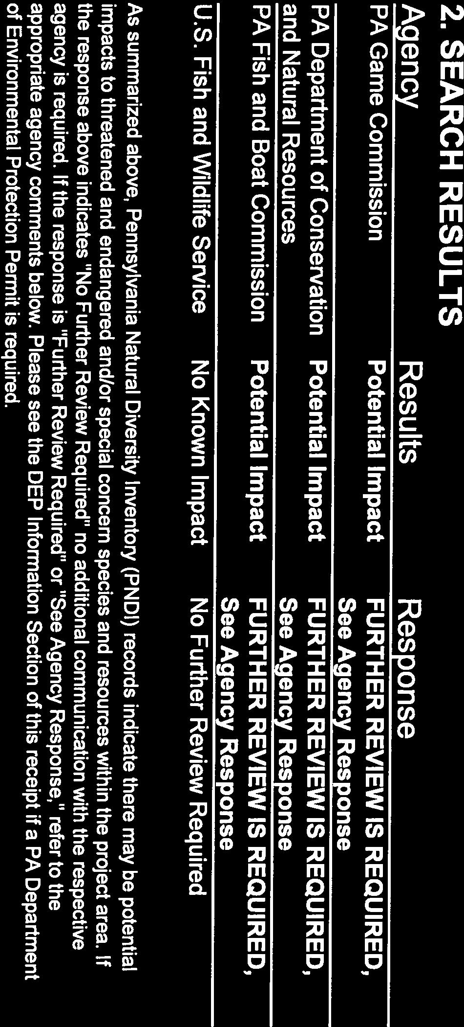
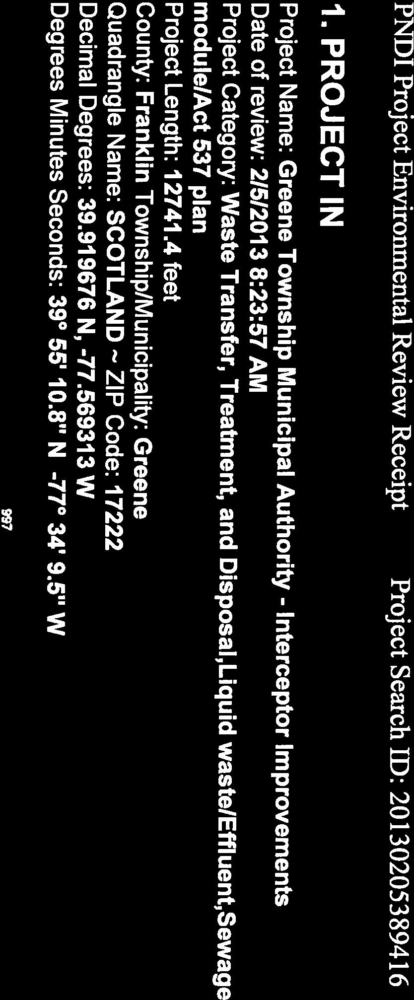
112

113


114

115

116

117

118


119

120


121
122 Pennsylvania Department of Fish and Boat Commission


123

124


125
126
127
128

129
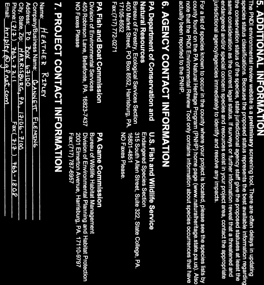

130

131


132
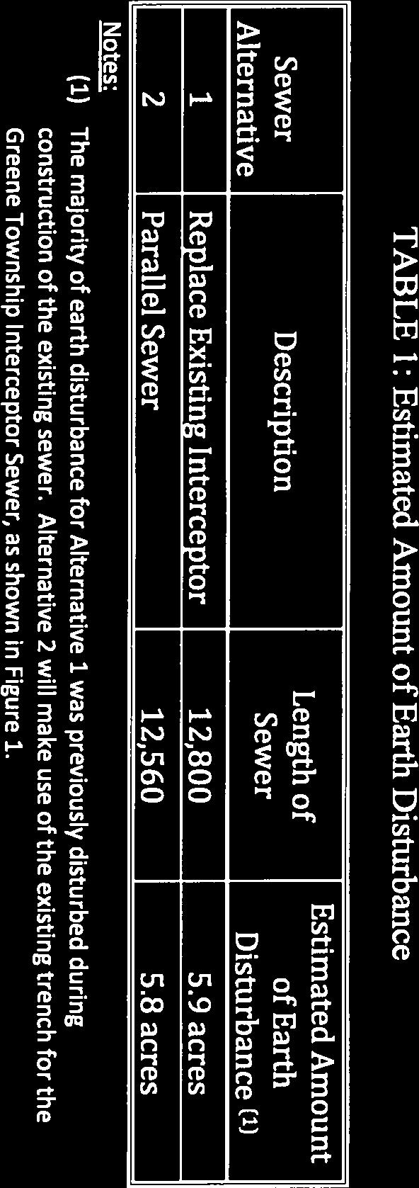
133
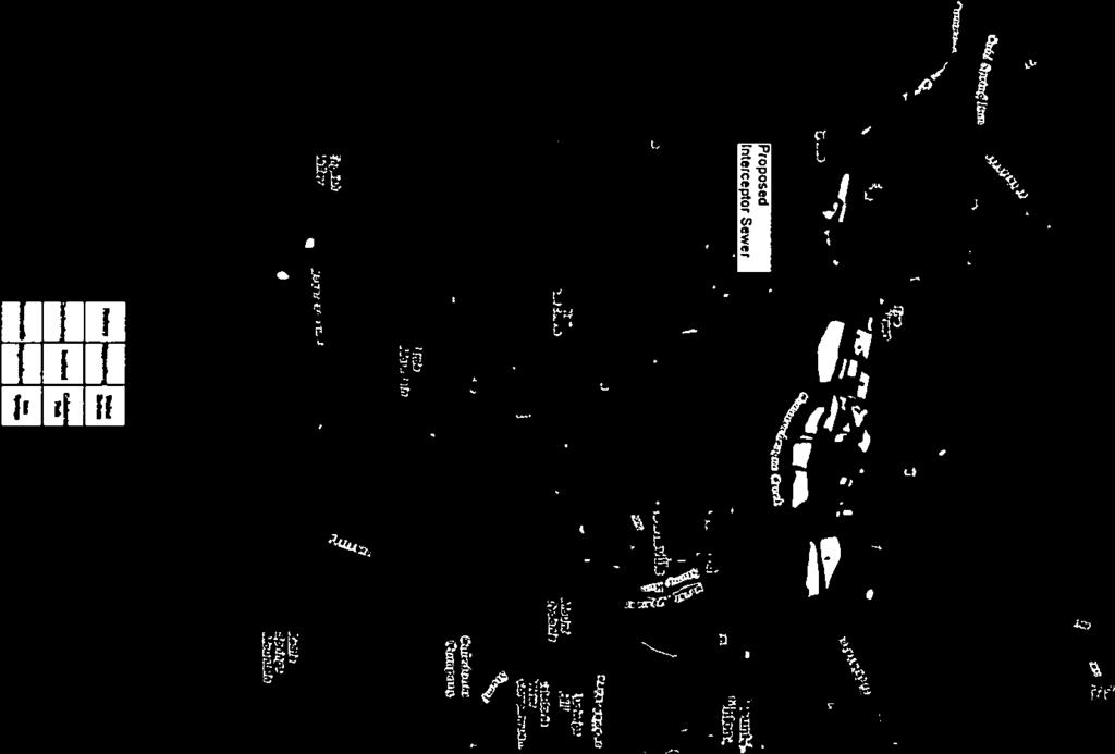


134
135 Pennsylvania Game Commission


136
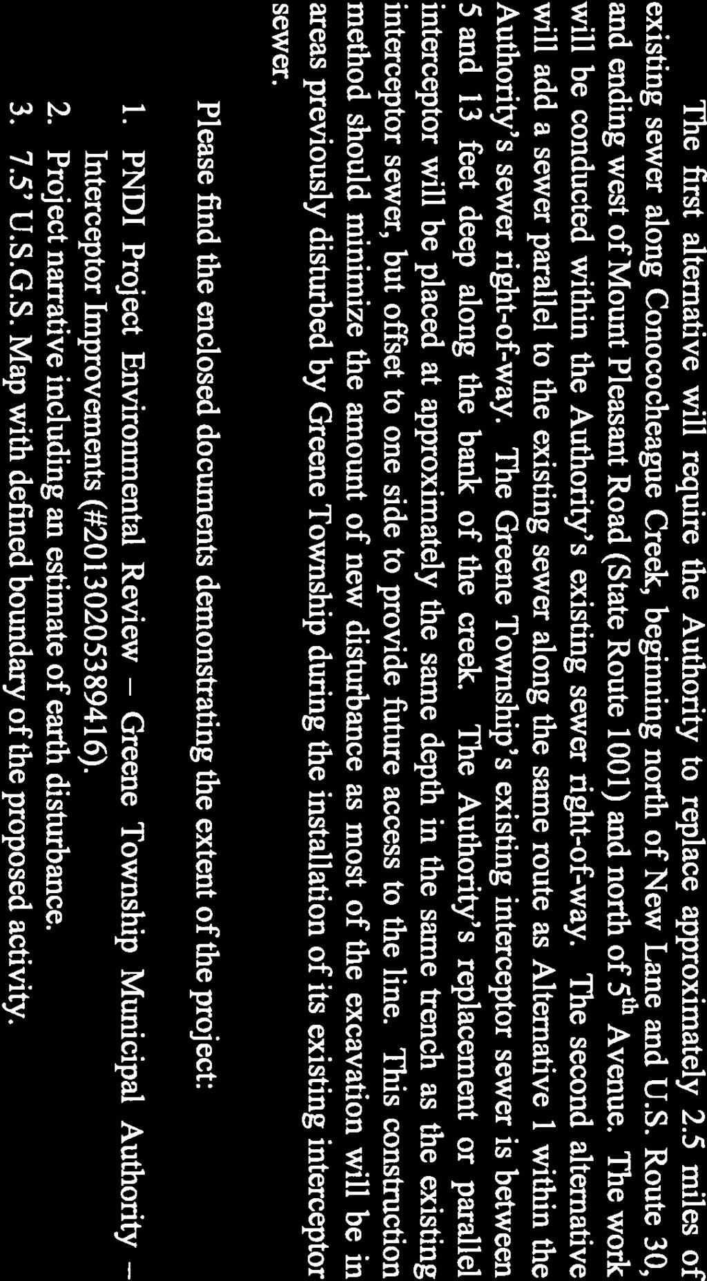

137
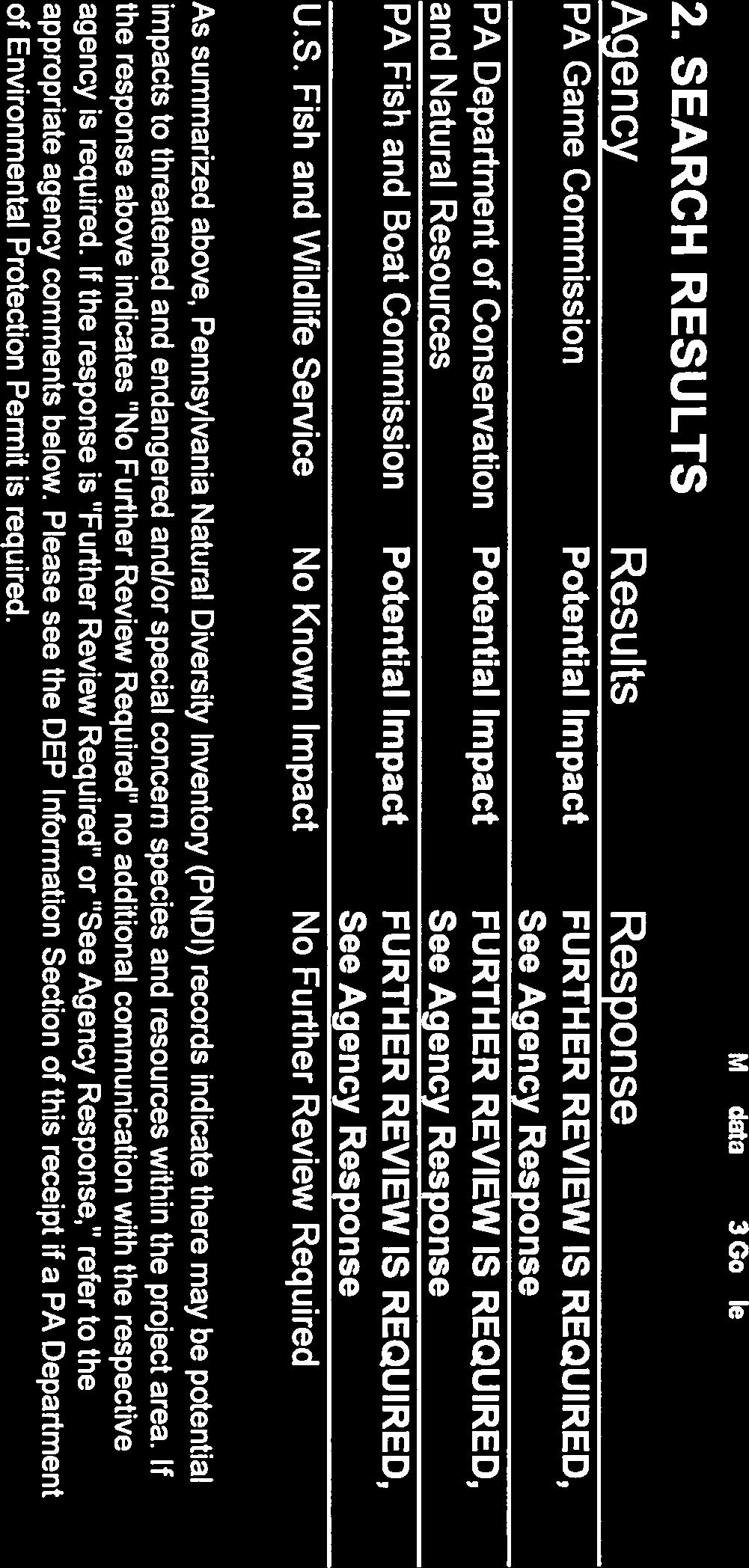
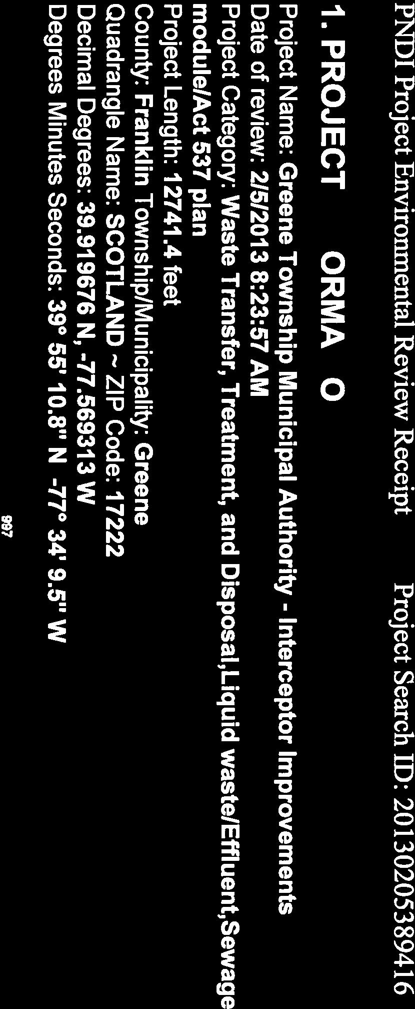


138

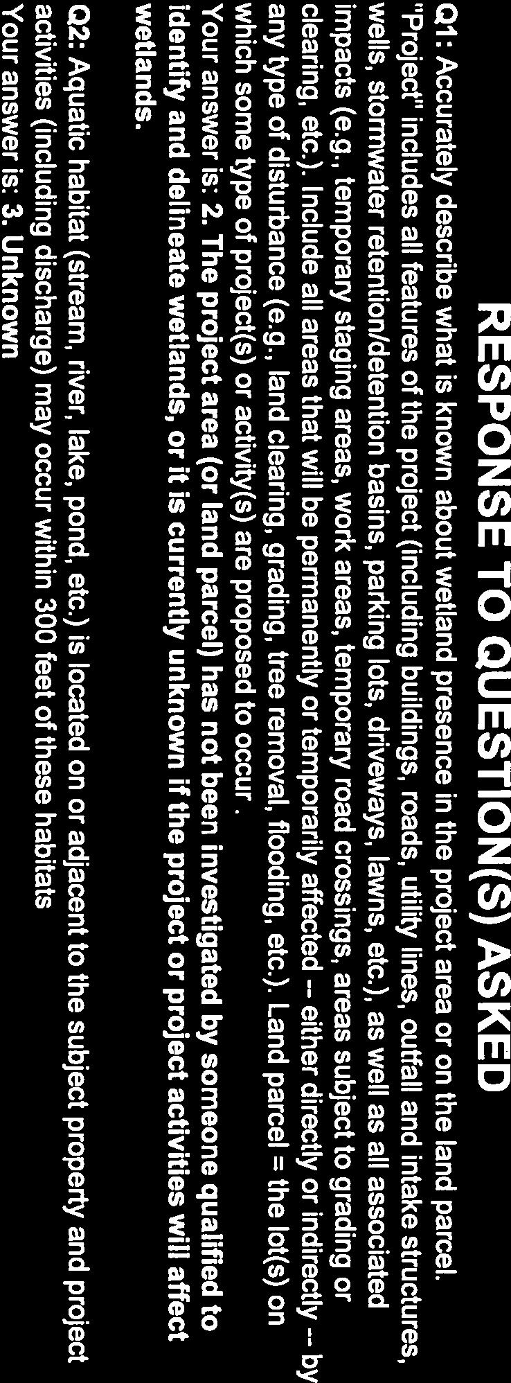
139

140


141

142

143

144

145
146


147
148 Appendix E Appendix E
149 Pennsylvania Natural Diversity Index Responses
150 BUREAU OF FORESTRY February 26, 2013 PNDI Number: Heather Ripley Gannett Fleming, Inc. P.O. Box Harrisburg, PA (hard copy will not follow) Re: Greene Township Municipal Authority Interceptor Improvements Greene Township, Franklin County, PA Dear Ms. Ripley, Thank you for the submission of the Pennsylvania Natural Diversity Inventory (PNDI) Environmental Review Receipt Number for review. PA Department of Conservation and Natural Resources screened this project for potential impacts to species and resources under DCNR s responsibility, which includes plants, terrestrial invertebrates, natural communities, and geologic features only. Potential Impact Anticipated PNDI records indicate species or resources under DCNR s jurisdiction are located in the project vicinity. Based on a detailed PNDI review, DCNR determined potential impacts to the following threatened or endangered species or species of special concern. Scientific Name Common Name PA Current Status PA Proposed Status Carex prairea Prairie Sedge Threatened Threatened Juncus arcticus var. littoralis Baltic Rush Threatened Threatened Lathyrus palustris Marsh Vetchling Undetermined Endangered Salix myricoides Broad-leaved Willow Not Listed Endangered Survey Request DCNR requests a survey for the following species: Carex prairea (Prairie Sedge): prefers wet calcareous marshes and fens; fruits June July Juncus arcticus var. littoralis (Baltic Rush): prefers calcareous swamps and shores; flowers/fruits late May September Lathyrus palustris (Marsh Vetchling): prefers shores, moist meadows, sand plains, swamps, and thickets; flowers June August Salix myricoides (Broad-leaved Willow): prefers stream banks and swamps; flowers in May A survey for the above species should be conducted by a qualified botanist at the appropriate time of year and then submitted to our office for review. Your botanist should carefully review the new DCNR Botanical Survey Protocols available at These protocols are recommended to ensure that the all necessary information is collected and that survey reports are prepared properly. It is the expectation of DCNR that these protocols will be followed when conducting surveys for species under our jurisdiction. Your botanist should fill out the field survey form while performing their survey: Contact our office prior to the survey for detailed information about the species, or for a list of qualified surveyors. conserve sustain enjoy P.O. Box 8552, Harrisburg, PA (fax) An Equal Opportunity Employer dcnr.state.pa.us Printed on Recycled Paper

151 PNDI Number: Any target and non-target state-listed species found during the site visit should be reported to our office. Mitigation measures and monitoring may be requested if species or communities of special concern are found on or adjacent to site. If the land type(s) does not exist on site, a survey may not be necessary; please submit a habitat assessment report which describes the current land cover, habitat types, and species found on site. This response represents the most up-to-date review of the PNDI data files and is valid for two (2) years only. If project plans change or more information on listed or proposed species becomes available, our determination may be reconsidered. For PNDI project updates, please see the PNHP website at for guidance. As a reminder, this finding applies to potential impacts under DCNR s jurisdiction only. Visit the PNHP website for directions on contacting the Commonwealth s other resource agencies for environmental review. Should you have any questions or concerns, please don t hesitate to contact me by phone ( ) or via (c-jryndock@pa.gov). Sincerely, Jason Ryndock, Ecological Information Specialist Bureau of Forestry, Ecological Services Section Pennsylvania Natural Heritage Program Rebecca H. Bowen, Section Chief Bureau of Forestry, Ecological Services Section Pennsylvania Natural Heritage Program conserve sustain enjoy P.O. Box 8552, Harrisburg, PA (fax) An Equal Opportunity Employer dcnr.state.pa.us Printed on Recycled Paper
152 Appendix F Appendix F
153 Pennsylvania Historical Museum Commission Cultural Response Inquiry


154


155
156
157

158


159
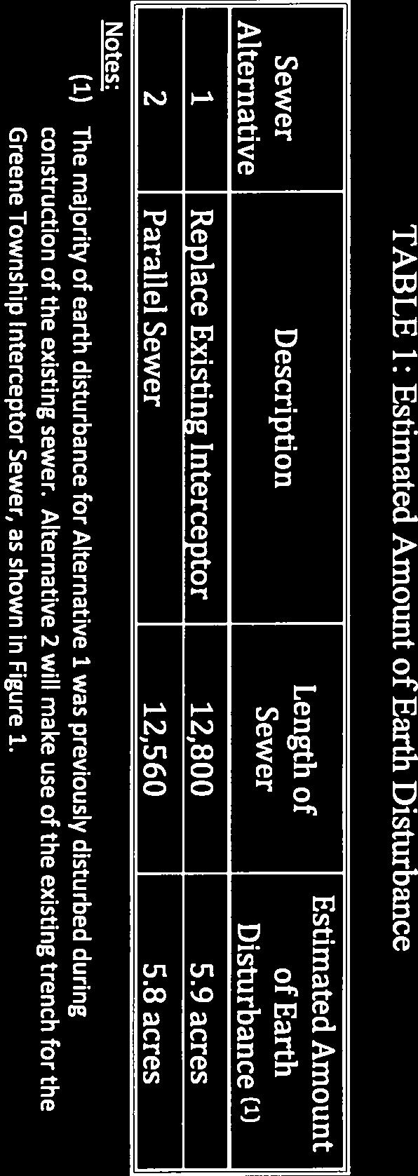
160
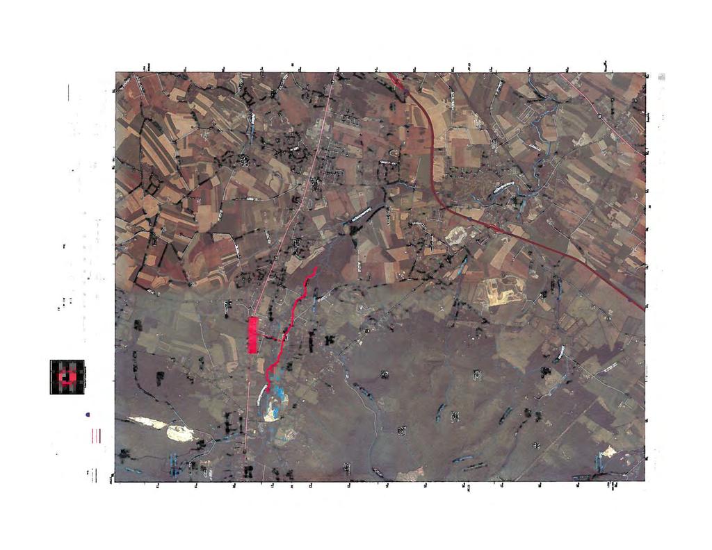


161
162 Appendix G Appendix G
163 Pennsylvania Historical Museum Commission Response


164


165
ACT 537 SPECIAL STUDY WASTEWATER CONVEYANCE SYSTEM CAPACITY ANALYSIS WASHINGTON TOWNSHIP MUNICIPAL AUTHORITY
 ACT 537 SPECIAL STUDY WASTEWATER CONVEYANCE SYSTEM CAPACITY ANALYSIS for WASHINGTON TOWNSHIP MUNICIPAL AUTHORITY WASHINGTON TOWNSHIP, FRANKLIN COUNTY, PENNSYLVANIA Prepared by: CET Engineering Services
AUTHORITY OF THE BOROUGH OF CHARLEROI WASHINGTON COUNTY, PENNSYLVANIA ACT 537 SEWAGE FACILITIES PLAN UPDATE
 PLAN SUMMARY AUTHORITY OF THE BOROUGH OF CHARLEROI WASHINGTON COUNTY, PENNSYLVANIA ACT 537 SEWAGE FACILITIES PLAN UPDATE The Pennsylvania Sewage Facilities Act (Act 537) was enacted by the Pennsylvania
Infiltration and Inflow. Michael Sassaman Phone
 Infiltration and Inflow Michael Sassaman msassaman@entecheng.com Phone 610-373-3345 Inflow and Infiltration PA DEP Learning Objectives Do you have Excessive I/I? Sources of Inflow and Infiltration I/I
Chapter 8 Addressing I/I Issues and High Flows
 Chapter Outline Chapter 8 Addressing I/I Issues and High Flows This chapter is organized into the following sections: Introduction Background Estimation of Infiltration Volume Conveyance Costs Effect of
Storm Water and Sanitary Sewer
 Public Works Department Summary Report on Planned Capital Improvements Storm Water and Sanitary Sewer Introduction Public Works has assembled this summary report to highlight major capital improvements
Metropolitan St. Louis Sewer District PRIVATE INFILTRATION and INFLOW REDUCTION PROGRAM
 PRIVATE INFILTRATION and INFLOW REDUCTION PROGRAM October 27, 2012 TABLE OF CONTENTS 1.0 INTRODUCTION... 1 2.0 PROPOSED REMEDIAL ACTION PLAN... 1 3.0 IDENTIFICATION AND CORRECTION OF PRIVATE LATERAL SOURCES...
SSO- WDR Compliance Workshop Electronic Reporting: Reporting Requirements & Tips. Sewer System Management Plan Chapter
 Chapter Contents Introduction SSMP Requirements and Suggested Content SSMP Preparation Deadlines Introduction This chapter provides a brief overview of the GWDR requirements for an SSMP and provides some
STORMWATER RUNOFF AND WATER QUALITY IMPACT REVIEW
 SUBCHAPTER 8 STORMWATER RUNOFF AND WATER QUALITY IMPACT REVIEW 7:45-8.1 Purpose and scope of review Except for those projects expressly exempted by this chapter or waived by the Commission, the Commission
EDGMONT TOWNSHIP DELAWARE COUNTY
 EDGMONT TOWNSHIP DELAWARE COUNTY 1000 Gradyville Road Gradyville, PA 19039 SEWAGE FACILITIES PLAN UNDER PENNSYLVANIA ACT 537 2010 SPECIAL STUDY December 2010 Prepared by: Bradford Engineering Associates,
CHAPTER 110 SEWAGE DISPOSAL
 110-1. Title. 110-6. System rehabilitation. 110-2. Purpose. 110-7. Liability. 110-3. Definitions. 110-8. Conflict with other 110-4. Applicability. regulations. 110-5. Applicable standards for sewage 110-9.
Updating the MWRD s Excessive Infiltration and Inflow Control Program. February 19, 2014 Southwest Conference of Mayors Chicago Ridge, Illinois
 Updating the MWRD s Excessive Infiltration and Inflow Control Program February 19, 2014 Southwest Conference of Mayors Chicago Ridge, Illinois MWRD SEPARATE SEWER AND COMBINED SEWER AREAS LEGEND: Separate/Unsewered
Appendix J. Clean Water Nashville Overflow Abatement Program GUIDANCE FOR DESIGN PERMIT INFORMATION. Version 3.0
 Appendix J Clean Water Nashville Overflow Abatement Program GUIDANCE FOR DESIGN PERMIT INFORMATION Version 3.0 April 2015 Table of Contents Section 1 General Information... 1 Section 2 State of Tennessee
NIAGARA REGION. Pollution Prevention Control Plan for the Town of Niagara-On-The-Lake Wastewater Collection System
 Welcome to the NIAGARA REGION Pollution Prevention Control Plan for the Town of Niagara-On-The-Lake Wastewater Collection System MUNICIPAL CLASS ENVIRONMENTAL ASSESSMENT Public Information Centre Please
DEPARTMENT OF ENVIRONMENTAL PROTECTION Bureau of Water Quality Protection. Design Criteria - Wetlands Replacement/Monitoring
 DEPARTMENT OF ENVIRONMENTAL PROTECTION Bureau of Water Quality Protection DOCUMENT NUMBER: 363-0300-001 TITLE: Design Criteria - Wetlands Replacement/Monitoring EFFECTIVE DATE: February 11, 1997 AUTHORITY:
Northfield Township WWTP Capacity Evaluation Report
 Northfield Township WWTP Capacity Evaluation Report March 18, 2015 PRESENTED TO PRESENTED BY Northfield Township 8350 Main Street Suite A Whitmore Lake, Michigan 48189 Tetra Tech 710 Avis Drive Suite 100
COON CREEK WATERSHED DISTRICT PERMIT REVIEW. Spring Lake Park Schools Westwood Middle School st Avenue NE, Spring Lake Park, MN 55432
 PAN 16-112, Westwood Middle School, Page 1 of 6 COON CREEK WATERSHED DISTRICT PERMIT REVIEW MEETING DATE: August 22, 2016 AGENDA NUMBER: 10 FILE NUMBER: 16-112 ITEM: Westwood Middle School RECOMMENDATION:
a landowner whose parcel was subjected to the discharge of a neighbor's ditch which was being used to drain a swamp;
 PA Act 167 Watershed Stormwater Management Planning DEFINITION Stormwater management has been traditionally defined as measures used by property owners and local governments to limit the amount of stormwater
Wastewater Master Facility Report. (Project Name) (Project Basin Location)
 (Project Basin Location)") Wastewater Master Facility Report For (Project Name) (Project Basin Location) The Wastewater Master Facility Report for (Project name) dated (Date); located in the (Basin Name) Basin has been completed
Wastewater Master Facility Report For (Project Name) (Project Basin Location) The Wastewater Master Facility Report for (Project name) dated (Date); located in the (Basin Name) Basin has been completed
TABLE OF CONTENTS 4.17 UTILITIES AND SERVICE SYSTEMS...
 TABLE OF CONTENTS 4.17 UTILITIES AND SERVICE SYSTEMS... 4.17-1 4.17.0 Introduction... 4.17-1 4.17.1 Methodology... 4.17-2 4.17.2 Existing Conditions... 4.17-2 4.17.3 Impacts... 4.17-4 4.17.4 Applicant-Proposed
AS A COURTESY, PLEASE TURN OFF CELL PHONES AND PAGERS WHILE MEETING IS IN PROGRESS.
 Table of Contents Agenda 2 Wastewater Treatment Plant (WWTP) Hydraulic Capacity Update Staff Report 3 WWTP Capacity Outline 5 WWTP Capacity Charts 6 Drainage Concerns on Oak Hill Drive and Quail Drive
Environmental Information Worksheet
 Environmental Information Worksheet Water System Owner (Attach additional sheets if necessary) Needs and Alternatives Provide a brief narrative that describes: Current drinking water system needs. Project
E. STORMWATER MANAGEMENT
 E. STORMWATER MANAGEMENT 1. Existing Conditions The Project Site is located within the Lower Hudson Watershed. According to the New York State Department of Environmental Conservation (NYSDEC), Lower Hudson
Chapter 2 ADMINISTRATIVE PROCEDURES
 Chapter 2 2.01 General 2.01.1 Application of Chapter 2.01.2 Fees 2.02 Pre-Development Site Certification and Assessment 2.03 Construction Permits 2.03.1 Site Development Permit 2.03.2 Development Permits
Pennsylvania Stormwater Best Management Practices Manual. Chapter 3. Stormwater Management Principles and Recommended Control Guidelines
 Pennsylvania Stormwater Best Management Practices Manual Chapter 3 Stormwater Management Principles and Recommended Control Guidelines 363-0300-002 / December 30, 2006 Chapter 3 Stormwater Management Principles
Stormwater Management Studies PDS Engineering Services Division ES Policy # 3-01
 Stormwater Management Studies PDS Engineering Services Division Revised Date: 2/28/08 INTRODUCTION The City of Overland Park requires submission of a stormwater management study as part of the development
Municipal Stormwater Ordinances Summary Table
 APPENDIX F Municipal Ordinances Summary Table Municipality Abington Bryn Athyn Borough Hatboro Borough Ordinance, SALDO Runoff equals pre post Erosion Sediment Control Water Quality Requirements Any which
Streamlining I/I Repairs in Berlin Charter Township
 Case Study: Streamlining I/I Repairs in Berlin Charter Township Presented by: Rich Grant, PE Agenda Discussion of the problems & the SAW I/I Evaluation & SSES = Asset Management Groundtruthing of Results
Table of Contents. Page Title Sheet and Index Project History and Summary Work Summary Overview 3-7
 Summary Final Report EPA Assistance ID Number: XP-00E59701-2 : Excess Flow Reduction Efforts Evergreen Farmington Sewage System Manhole Rehab and Sewer Lining Table of Contents Page Title Sheet and Index
DEPARTMENT OF ENVIRONMENTAL PROTECTION BUREAU OF MINING AND RECLAMATION. Coal Refuse Disposal - Site Selection
 DEPARTMENT OF ENVIRONMENTAL PROTECTION BUREAU OF MINING AND RECLAMATION DOCUMENT NUMBER: 563-2113-660 TITLE: Coal Refuse Disposal - Site Selection EFFECTIVE DATE: February 8, 1999 AUTHORITY: The Coal Refuse
8. A. AQUATIC HABITATS
 ENCLOSURE C S.R. 1006 SECTION 80S DELAWARE CANAL BRIDGE REHABILITATION PROJECT, TINICUM TOWNSHIP, BUCKS COUNTY, PENNSYLVANIA DESCRIPTION OF AQUATIC HABITAT 8. A. AQUATIC HABITATS (1) Food Chain Production-
OVERVIEW CAPACITY & CONDITION
 OVERVIEW The nation s 14,748 wastewater treatment plants protect public health and the environment. Years of treatment plant upgrades and more stringent federal and state regulations have significantly
EFFECT OF UPSTREAM DEVELOPMENT ON THE CLEAR CREEK AREA
 EFFECT OF UPSTREAM DEVELOPMENT ON THE CLEAR CREEK AREA Technical Memorandum Farming in the Floodplain Project Prepared for May 2017 PCC Farmland Trust Photo credit: Google Earth TABLE OF CONTENTS Page
CLIENT INFORMATION SITE INFORMATION
 Form COMMONWEALTH OF PENNSYLVANIA DEPARTMENT OF ENVIRONMENTAL PROTECTION GENERAL INFORMATION FORM AUTHORIZATION APPLICATION Before completing this General Information Form (GIF), read the step-by-step
PLAN SUMMARY HARBORCREEK TOWNSHIP SEWER AUTHORITY ACT 537 SEWAGE FACILITIES PLAN
 PLAN SUMMARY HARBORCREEK TOWNSHIP SEWER AUTHORITY ACT 537 SEWAGE FACILITIES PLAN I. INTRODUCTION The Act 537 Program is administered by the PA Department of Environmental Protection (PA DEP) and their
DRAINAGE AND NATURAL AQUIFER GROUNDWATER RECHARGE ELEMENT
 Goal 7.0. To optimize integrated stormwater management in order to reduce damage and impacts from sea level rise and flooding, promotes recharge to the Surficial Aquifer System (SAS), improve and protect
System Evaluation and Capacity Assurance Plan
 City of Cedar Hills System Evaluation and Capacity Assurance Plan The City of Cedar Hills believes that one of the keys to preventing sanitary sewer overflows is to evaluate system capacity and to monitor
POLICY FOR NATURAL RESOURCE MANAGEMENT AREAS
 POLICY FOR NATURAL RESOURCE MANAGEMENT AREAS I. POLICY STATEMENT Auburn University's (the University's) "Policy for Natural Resource Management Areas" implements the Campus Master Plan Land Use Element
S.O.P. No. HMD
 Page: 1 of 9 PURPOSE: To establish (SOP) for submission requirements, review process and approval of applications for Non-vehicular Access Permits for the purpose of connection or discharge to any MassDOT
STREAM AND BUFFER AREA PROTECTION/RESTORATION
 STREAM AND BUFFER AREA PROTECTION/RESTORATION AMENDMENT OPTIONS TO STRENGTHEN POLICY IN HEADWATERS AREAS DRAFT SUBSEQUENT TO THE JANUARY 25, 2007 MEETING OF THE PLANNING COMMISSION ENVIRONMENT COMMITTEE
PHASE 1 OF THE CONSENT DECREE/ WET WEATHER IMPROVEMENT PROGRAM ACCOMPLISHMENTS THROUGH 2017
 PHASE 1 OF THE CONSENT DECREE/ WET WEATHER IMPROVEMENT PROGRAM ACCOMPLISHMENTS THROUGH 2017 MSD is delivering Phase 1 is under the original cost estimate Improving Trends in Water Quality MSDGC has completed
Municipal Stormwater Management Planning
 Municipal Stormwater Management Planning Christopher C. Obropta, Ph.D., P.E. Water Resources Extension Specialist with Rutgers Cooperative Extension Assistant Professor with Department of Environmental
Pollution Reduction Plan For Municipal Separate Storm Sewer System
 Pollution Reduction Plan For Municipal Separate Storm Sewer System West Chester University of Pennsylvania September 2017 Table of Contents Purpose and Scope Permit Requirements Pollution Reduction Conclusion
Wastewater Flow Monitoring Services
 Wastewater Flow Monitoring Services For San Gabriel, CA July 13, 2015 through July 21, 2015 Revised October 9, 2015 Leaders in Sewer Flow Monitoring Services 601 N. Parkcenter Dr., Suite 209 Santa Ana,
CHAPTER 9: SANITARY SEWER INTRODUCTION FORECASTS CHAPTER 9: SANITARY SEWER 9-1
 CHAPTER 9: SANITARY SEWER INTRODUCTION The Metropolitan Land Planning Act (amended 1995) requires local governments to prepare comprehensive plans and submit them to the Metropolitan Council to determine
Review Zone Application for D&R Canal Commission Decision
 Review Zone Application for D&R Canal Commission Decision MEETING DATE: December 21, 2016 DRCC #: 16-4345 Latest Submission Received: December 7, 2016 Applicant: Robert McCarthy, PE PSE&G 4000 Hadley Road,
Tunnel Works. How we got here - Fort Wayne s Consent Decree. Tunnel Works Program Frequently Asked Questions
 City Utilities operates the largest municipally-owned wastewater collection and treatment system in Indiana. The system serves 161 square miles and includes 1,014 miles of sanitary sewer lines, 365 miles
CHESAPEAKE BAY TMDL ACTION PLAN ( MS4 General Permit)
") CHESAPEAKE BAY TMDL ACTION PLAN (2013 2018 MS4 General Permit) Piedmont Virginia Community College A Plan for Achieving a 5% Reduction of Existing Loads June 30, 2015 Main Campus This plan satisfies the
CHESAPEAKE BAY TMDL ACTION PLAN (2013 2018 MS4 General Permit) Piedmont Virginia Community College A Plan for Achieving a 5% Reduction of Existing Loads June 30, 2015 Main Campus This plan satisfies the
APPENDIX H Guidance for Preparing/Reviewing CEQA Initial Studies and Environmental Impact Reports
 APPENDIX H H.1 Guidance for Preparing and Reviewing CEQA Initial Studies Step 1: Consider the Project Characteristics as Provided by the Project Applicant Review the project application and draft plan
PIMA COUNTY COMPREHENSIVE PLAN CO PIMA COUNTY REGIONAL COMPREHENSIVE PLAN POLICY MAJOR PLAN AMENDMENT
 PIMA COUNTY COMPREHENSIVE PLAN CO7-07-04 PIMA COUNTY REGIONAL COMPREHENSIVE PLAN POLICY MAJOR PLAN AMENDMENT Arizona law [A.R.S. 11-821(C)(3)] requires: Planning for water resources that addresses: a)
Dam Failure Hazard Profile
 Appendix F Dam Failure Hazard Profile F-1 THIS PAGE INTENTIONALLY LEFT BLANK F-2 4.3.12. Dam Failure 4.3.12.1. Location and Extent Dam failures most often occur during or after a massive rainfall, flooding,
INFRASTRUCTURE ELEMENT
 Goals, Objectives and Policies INFRASTRUCTURE ELEMENT SANITARY SEWER GOAL 4.A.1.: PROVIDE ADEQUATE CENTRAL SANITARY SEWAGE FACILITIES FOR RESIDENTIAL AND NON-RESIDENTIAL DEVELOPMENT AND REDEVELOPMENT IN
HYDRAULIC HYDRODYNAMIC MODELING AS AN EFFECTIVE MANAGEMENT TOOL FOR LARGE COLLECTION SYSTEMS - THE L.A. STORY
 HYDRAULIC HYDRODYNAMIC MODELING AS AN EFFECTIVE MANAGEMENT TOOL FOR LARGE COLLECTION SYSTEMS - THE L.A. STORY Fernando Gonzalez, Adel Hagekhalil, Bryan Trussell, City of Los Angeles Bureau of Sanitation
INFLOW DESIGN FLOOD CONTROL SYSTEM PLAN PLANT GREENE COUNTY ASH POND ALABMA POWER COMPANY
 INFLOW DESIGN FLOOD CONTROL SYSTEM PLAN PLANT GREENE COUNTY ASH POND ALABMA POWER COMPANY Section 257.82 of EPA s regulations requires the owner or operator of an existing or new CCR surface impoundment
IV. ENVIRONMENTAL IMPACT ANALYSIS G. HYDROLOGY/WATER QUALITY
 IV. ENVIRONMENTAL IMPACT ANALYSIS G. HYDROLOGY/WATER QUALITY ENVIRONMENTAL SETTING The project site is located in the Wilshire community of the City of Los Angeles and is bound by S. Wetherly Drive to
iswm TM Criteria Manual City of Azle Section 14 City of Azle Subdivision Ordinance DRAFT-June Chapter 1
 City of Azle Section 14 City of Azle Subdivision Ordinance DRAFT-June 2010... Chapter 1 i CITY OF AZLE iswm CRITERIA MANUAL FOR SITE DEVELOPMENT AND CONSTRUCTION Incorporating the Regional NCTCOG Integrated
Management of Aging Wastewater Infrastructure -- Challenges and Strategies --
 Management of Aging Wastewater Infrastructure -- Challenges and Strategies -- Jerry N. Johnson, General Manager District of Columbia Water and Sewer Authority Washington, D.C. Overview of the Aging Situation
WATER MANAGEMENT PLAN FOR UNCONVENTIONAL GAS WELL DEVELOPMENT
 COMMONWEALTH OF PENNSYLVANIA Example Format DEPARTMENT OF ENVIRONMENTAL PROTECTION OFFICE OF OIL AND GAS MANAGEMENT WATER MANAGEMENT PLAN FOR UNCONVENTIONAL GAS WELL DEVELOPMENT APPLICANT AND PLAN COVERAGE
Wastewater Treatment Systems, Wastewater Issues and Permits
 Wastewater Treatment Systems, Wastewater Issues and Permits Lucas Gregory Texas Water Resources Institute November 29, 2017 Debbie Magin Guadalupe Blanco River Authority Ryan Gerlich Texas A&M AgriLife
Chapter 10 Natural Environment
 Chapter 10 Natural Environment Existing Conditions The Natural Environment Element addresses the protection, conservation, preservation, and restoration of the natural resources the Bayview Ridge Subarea,
Chapter 4. Drainage Report and Construction Drawing Submittal Requirements
 4.0 Introduction The requirements presented in this section shall be used to aid the design engineer or applicant in the preparation of drainage reports, drainage studies, and construction drawings for
Luzerne County Act 167 Phase II
 Executive Summary Luzerne County Act 167 Phase II Stormwater Management Plan 613 Baltimore Drive, Suite 300 Wilkes-Barre, PA 18702 Voice: 570.821.1999 Fax: 570.821.1990 www.borton-lawson.com 3893 Adler
INFLOW DESIGN FLOOD CONTROL SYSTEM PLAN 40 C.F.R. PART PLANT BOWEN ASH POND 1 (AP-1) GEORGIA POWER COMPANY
 GEORGIA POWER COMPANY") INFLOW DESIGN FLOOD CONTROL SYSTEM PLAN 40 C.F.R. PART 257.82 PLANT BOWEN ASH POND 1 (AP-1) GEORGIA POWER COMPANY EPA s Disposal of Coal Combustion Residuals from Electric Utilities Final Rule (40 C.F.R.
INFLOW DESIGN FLOOD CONTROL SYSTEM PLAN 40 C.F.R. PART 257.82 PLANT BOWEN ASH POND 1 (AP-1) GEORGIA POWER COMPANY EPA s Disposal of Coal Combustion Residuals from Electric Utilities Final Rule (40 C.F.R.
WATER RESOURCES CHAPTER 7 INTRODUCTION KEY PRINCIPLES TO IMPLEMENTING THE WATER RESOURCES PLAN INCLUDE: WATER SUPPLY AND DISTRIBUTION INTRODUCTION
 WATER RESOURCES CHAPTER 7 INTRODUCTION KEY PRINCIPLES TO IMPLEMENTING THE WATER RESOURCES PLAN INCLUDE: Greenway Connections Protect and enhance drainage corridors Compact Development Continue efficient,
STATE OF MINNESOTA MINNESOTA POLLUTION CONTROL AGENCY
 STATE OF MINNESOTA MINNESOTA POLLUTION CONTROL AGENCY In the Matter of the Decision on the Need for an Environmental Impact Statement for the Proposed Remer Wastewater Treatment Facility Expansion FINDINGS
Improved Inflow & Infiltration (I&I) Monitoring Program
 Monitoring Program") City of Abbotsford Improved Inflow & Infiltration (I&I) Monitoring Program Submission For 2009 UBCM Community Excellence Awards Best Practices City of Abbotsford Improved Inflow & Infiltration (I&I) Monitoring
City of Abbotsford Improved Inflow & Infiltration (I&I) Monitoring Program Submission For 2009 UBCM Community Excellence Awards Best Practices City of Abbotsford Improved Inflow & Infiltration (I&I) Monitoring
GOALS, OBJECTIVES, & POLICIES
 ELEMENT 9 INFRASTRUCTURE ELEMENT STORM WATER MANAGEMENT SUB-ELEMENT Goal 1 To provide adequate stormwater management facilities and services to meet the present and future needs of the University and to
APPENDIX A. NEPA Assessment Checklist
 APPENDI A NEPA Assessment Checklist NEPA CHECKLIST DATE: January 12, 2009 PREPARER: Frederick Wells, RLA PIN and Project Title: Surplus Property Request Wilder Balter Partners Marketplace Town of Newburgh,
Stormwater Quality Extended Detention Basin Operation and Maintenance (O&M) Manual. for: Located at: Prepared for: Prepared by:
 Manual. for: Located at: Prepared for: Prepared by:") Stormwater Quality Extended Detention Basin Operation and Maintenance (O&M) Manual for: Insert Development Name Located at: Insert Address Prepared for: Insert Property Owner Name, Address, and Phone Number
Stormwater Quality Extended Detention Basin Operation and Maintenance (O&M) Manual for: Insert Development Name Located at: Insert Address Prepared for: Insert Property Owner Name, Address, and Phone Number
Good morning, Chairman Yaw, Chairman Yudichak, Chairman Vulakovich, Chairman Costa,
 Testimony of Patrick McDonnell, Secretary Pennsylvania Department of Environmental Protection Joint Hearing on Flooding and Emergency Response Senate Environmental Resources & Energy and Veterans Affairs
EAST VALLEY WATER DISTRICT Wastewater Collection System Master Plan. Table 4-1 Capacity Evaluation d/d Criteria
 EAST VALLEY WATER DISTRICT Wastewater Collection System Master Plan 4 Capacity Analysis The capacity analysis used the calibrated dry weather and wet weather wastewater collection system model to evaluate
Chapter 6. Hydrology. 6.0 Introduction. 6.1 Design Rainfall
 6.0 Introduction This chapter summarizes methodology for determining rainfall and runoff information for the design of stormwater management facilities in the City. The methodology is based on the procedures
What is a stormwater utility fee?
 What is a stormwater utility fee? A stormwater utility fee is similar to a water or sewer utility fee. In essence, customers pay a fee to convey stormwater from their properties. The City of Goodlettsville
City of Fairmont Storm Water Pollution Prevention Plan (SWPPP) January 23, 2017
 January 23, 2017") City of Fairmont Storm Water Pollution Prevention Plan (SWPPP) January 23, 2017 Why is Water Quality Important? Water has always been important to Minnesota and is a key part of our history, culture, economy
City of Fairmont Storm Water Pollution Prevention Plan (SWPPP) January 23, 2017 Why is Water Quality Important? Water has always been important to Minnesota and is a key part of our history, culture, economy
SECTION 3 DRAINAGE. 3-1 General. 3-2 Drainage Ordinances and Legal Requirements
 SECTION 3 DRAINAGE 3-1 General All Drainage plans for proposed development shall be prepared by a Professional Engineer registered in Virginia, except as noted below. Further, their seal and signature
ARTICLE 8: INFILTRATION / INFLOW CONTROL PROGRAM
 ARTICLE 8: INFILTRATION / INFLOW CONTROL PROGRAM INTRODUCTION ( 800) Technical Guidance Manual Major components of the sanitary sewer system are the public sewer mains (mains) and privatelyowned sewer
Pennsylvania Stormwater Best Management Practices Manual DRAFT - JANUARY Section 1 Introduction and Purpose of Stormwater BMP Manual
 Pennsylvania Stormwater Best Management Practices Manual DRAFT - JANUARY 2005 Section 1 Introduction and Purpose of Stormwater BMP Manual This page intentionally left blank. Section 1 Introduction and
Maine Department of Environmental Protection Program Guidance on Combined Sewer Overflow Facility Plans
 Maine State Library Maine State Documents Land and Water Quality Documents Environmental Protection 9-1-1994 Maine Department of Environmental Protection Program Guidance on Combined Sewer Overflow Facility
Ponds. Pond A water impoundment made by excavating a pit, or constructing a dam or an embankment.
 POND SITE SELECTION AND CONSTRUCTION Uses, Planning, & Design David Krietemeyer Area Engineer USDA-NRCS June 20, 2008 Uses Considerations for Location of Commonly Used Terms Pond A water impoundment made
Holly Swartz and Jason Shirey
 Chapter 105 General Permits for Stream and Wetland Impacts DEP Ch. 105 CONTACTS FOR BERKS COUNTY: Holly Swartz and Jason Shirey What DEP Regulates Under Chapter 105 Waters of the Commonwealth, which includes
Supplemental Watershed Plan Agreement No. 10 for Neshaminy Creek Watershed Core Creek Dam (PA-620) Bucks County, Pennsylvania
 Bucks County, Pennsylvania") Supplemental Watershed Plan Agreement No. 10 for Neshaminy Creek Watershed Core Creek Dam (PA-620) Bucks County, Pennsylvania Project Authorization USDA's Small Watershed Program is carried out under the
Supplemental Watershed Plan Agreement No. 10 for Neshaminy Creek Watershed Core Creek Dam (PA-620) Bucks County, Pennsylvania Project Authorization USDA's Small Watershed Program is carried out under the
CHAPTER 6 COLLECTION SYSTEM HYDRAULIC MODEL
 CHAPTER 6 COLLECTION SYSTEM HYDRAULIC MODEL INTRODUCTION The District developed a hydraulic model of the sanitary sewer system as part the 2000 Wastewater Comprehensive Plan. The output from this model
INFLOW DESIGN FLOOD CONTROL SYSTEM PLAN 40 C.F.R. PART PLANT YATES ASH POND 3 (AP-3) GEORGIA POWER COMPANY
 GEORGIA POWER COMPANY") INFLOW DESIGN FLOOD CONTROL SYSTEM PLAN 40 C.F.R. PART 257.82 PLANT YATES ASH POND 3 (AP-3) GEORGIA POWER COMPANY EPA s Disposal of Coal Combustion Residuals from Electric Utilities Final Rule (40 C.F.R.
INFLOW DESIGN FLOOD CONTROL SYSTEM PLAN 40 C.F.R. PART 257.82 PLANT YATES ASH POND 3 (AP-3) GEORGIA POWER COMPANY EPA s Disposal of Coal Combustion Residuals from Electric Utilities Final Rule (40 C.F.R.
NPDES COMPLIANCE MONITORING STRATEGY AND ANNUAL COMPLIANCE INSPECTION PLAN OCTOBER 1, SEPTEMBER 30, 2018
 NPDES COMPLIANCE MONITORING STRATEGY AND ANNUAL COMPLIANCE INSPECTION PLAN OCTOBER 1, 2017 - SEPTEMBER 30, 2018 Introduction This document serves as the Pennsylvania Department of Environmental Protection
Scoring Groundwater Infiltration & Sewage Exfiltration Risk in a Sanitary Sewage Collection System. Meredith S. Moore Advisor: Dr.
 Scoring Groundwater Infiltration & Sewage Exfiltration Risk in a Sanitary Sewage Collection System Meredith S. Moore Advisor: Dr. Barry Evans July 20, 2015 Contents List of Figures... 2 List of Tables...
STORMWATER AND EROSION CONTROL PERMIT
 STORMWATER MANAGEMENT AND EROSION CONTROL PERMIT INSTRUCTIONS AND INFORMATION Any project that involves the disturbance of ANY quantity of land requires the applicant to receive approval for the project
CITY OF BOYNTON BEACH COMPREHENSIVE PLAN UTILITIES ELEMENT
 EXHIBIT B CITY OF BOYNTON BEACH COMPREHENSIVE PLAN UTILITIES ELEMENT PROPOSED AMENDMENTS Table of Contents Objective Page Sanitary Sewer Sub-Element 3A.1 Secure reserve capacity at the South Central Regional
NEW CASTLE CONSERVATION DISTRICT. through. (Name of Municipality) PLAN REVIEW APPLICATION DRAINAGE, STORMWATER MANAGEMENT, EROSION & SEDIMENT CONTROL
 PLAN REVIEW APPLICATION DRAINAGE, STORMWATER MANAGEMENT, EROSION & SEDIMENT CONTROL") NEW CASTLE CONSERVATION DISTRICT through (Name of Municipality) PLAN REVIEW APPLICATION DRAINAGE, STORMWATER MANAGEMENT, EROSION & SEDIMENT CONTROL Office use only: Received by Municipality: Received by
NEW CASTLE CONSERVATION DISTRICT through (Name of Municipality) PLAN REVIEW APPLICATION DRAINAGE, STORMWATER MANAGEMENT, EROSION & SEDIMENT CONTROL Office use only: Received by Municipality: Received by
SANITARY SEWER SYSTEM C.M.O.M. PROGRAM
 SANITARY SEWER SYSTEM C.M.O.M. PROGRAM Prepared by Bradley Bennett, P.E. Certified Collection System Operator March 2010 Table of Contents I. INTRODUCTION... 3 A. SANITARY SEWER SYSTEM DESCRIPTION... 3
Private Side Sewer Inspections for Sources of Inflow & Infiltration Frequently Asked Questions
 Private Side Sewer Inspections for Sources of Inflow & Infiltration Frequently Asked Questions As of Oct. 1, 2010, Tacoma property owners are required to have a certified inspection of their private side
Chapter 21 Stormwater Management Bylaw
 Chapter 21 Stormwater Management Bylaw SECTION 1. PURPOSE The purpose of this Bylaw is to: implement the requirements of the National Pollutant Discharge Elimination System (NPDES) General Permit for Storm
CORBIN AND NORDHOFF IV. ENVIRONMENTAL IMPACT ANALYSIS ENV EIR F. HYDROLOGY
 F. HYDROLOGY ENVIRONMENTAL SETTING Project Site The Project Site is located at 19601 Nordhoff Street in the Chatsworth area of the City of Los Angeles, California, within the Chatsworth - Porter Ranch
Suffolk Downs Redevelopment. Appendix G: Stormwater Management Supporting Documentation
 Suffolk Downs Redevelopment Expanded PNF Appendix G: Stormwater Management Supporting Documentation Suffolk Downs Redevelopment Phase 1 Stormwater Management Report Boston, Massachusetts 285402RP004 TABLE
Section Treatment of Sewage and Stormwater
 Section 300.6. Treatment of Sewage and Stormwater A. Definitions 1. Sewage: The Council has adopted the definition of sewage set forth under Title 46, Chapter 12, Section 1 or the General Laws, to wit:
CHESAPEAKE BAY TMDL ACTION PLAN ( MS4 General Permit)
") CHESAPEAKE BAY TMDL ACTION PLAN (2013 2018 MS4 General Permit) Central Virginia Community College A Plan for Achieving a 5% Reduction of Existing Loads June 30, 2015 Main Campus This plan satisfies the
CHESAPEAKE BAY TMDL ACTION PLAN (2013 2018 MS4 General Permit) Central Virginia Community College A Plan for Achieving a 5% Reduction of Existing Loads June 30, 2015 Main Campus This plan satisfies the
INSTRUCTIONS FOR USING THE GENERAL PERMIT...i A. GENERAL DESCRIPTION AND FEES
 COMMONWEALTH OF PENNSYLVANIA DEPARTMENT OF ENVIRONMENTAL PROTECTION BUREAU OF WATERWAYS ENGINEERING AND WETLANDS GENERAL PERMIT BWEW-GP-1 FISH HABITAT ENHANCEMENT STRUCTURES TABLE OF CONTENTS PAGE INSTRUCTIONS
SANITARY SEWER OVERFLOWS AND THE TEXAS COMMISSION ON ENVIRONMENTAL
 SANITARY SEWER OVERFLOWS AND THE TEXAS COMMISSION ON ENVIRONMENTAL Greg Diehl DFW Region Office Wastewater Work Leader QUALITY OVERVIEW: The TCEQ s SSO Initiative What is it and how does it work? The data
CHAPTER 5 WASTEWATER FLOWS
 CHAPTER 5 WASTEWATER FLOWS 5.1 REGIONAL FACILITIES Regional Water Recycling Plants Figure 5-1 illustrates the service area boundaries for IEUA s four water recycling plants. The four Regional facilities
4 Desired Levels of Service (LOS)
") 4 Desired Levels of Service (LOS) LOS are a key business driver and influence all asset management decisions. LOS statements describe the outputs Halton intends to deliver to its residents and commonly
4 Desired Levels of Service (LOS) LOS are a key business driver and influence all asset management decisions. LOS statements describe the outputs Halton intends to deliver to its residents and commonly
Agenda. Streamlining I/I Repairs in Berlin Charter Township.. Innovative Techniques
 Streamlining I/I Repairs in Berlin Charter Township.. Innovative Techniques MWEA Collections System Seminar September 2012 Presented by: Elaine Venema, PE Rich Grant, PE Agenda Discussion of the problems