Catchment Water Quality Protection
|
|
|
- Reginald Griffin
- 5 years ago
- Views:
Transcription

1 Catchment Water Quality Protection Policy and Guidelines for Planning Permit Applications & Government Planning Initiatives Final31 Oct 2013
2 Policy Coliban Water s vision is to contribute to improving living standards in our region. We realise this vision by actively contributing to regional sustainability. This Catchment Water Quality Protection Policy is a key component of our Sustainability Strategy and Environmental Policy. Human health is a priority Water is a vital commodity. Safe drinking water is essential to sustain life. The quality of domestic water sources has major impacts on human health. This gives domestic water supplies the highest importance in terms of catchment protection. All land use and development within a domestic water supply catchment must be sited and managed to ensure the protection of water quality and, therefore, human health. Precautionary principle is key The precautionary principle requires us to consider the cumulative impacts of diffuse contaminant sources in managing risks to water quality. These risks arise in water supply catchments from changing land use and development, including increasing densities of dwellings with on-site wastewater/septic tank treatment systems and the intensity of agricultural, commercial, industrial and other human activity. Risk management reflects precautionary principle We will balance economic, environmental, social and equity considerations, to protect and preserve benefits to both present and future generations. Excessive risk aversion can undermine development, however excessive risk taking could also compromise health. The greatest risk to public health from drinking water is contamination due to pathogenic micro-organisms. The precautionary principle means that protecting water sources is a paramount risk management objective that must not be compromised. We regard health risks as having the highest priority of any planning considerations. Multiple barriers protect water quality We will maintain robust multiple barriers against potential contamination. These barriers can be at stages of water collection, storage, treatment, transfer and distribution. The most effective barrier is protecting source waters at the collection stage. Page 2
3 Guidelines 1. Purpose The purpose of these Guidelines is to help ensure that, Declared Special Areas (Water Supply Catchments), under the Catchment and Land Protection Act 1994 (SWSCs) including the Eppalock SWSC 1 and others, that are used and developed, necessary protection is given to water quality and, therefore, human health. These Guidelines balance certainty for applicants and other users against the flexibility we need to respond to changing policy, legislation and circumstances. This flexibility means these Guidelines are subject to change. 2. Uses The main uses of these Guidelines are as follows Assessing planning permit applications As a referral authority, Coliban Water assesses planning permit applications referred to us by Council. 3 These applications are to: 4 Use, develop, subdivide or consolidate land construct a building or construct or carry out works demolish a building or works. If you are planning a particular use or development, please confirm with Council that your land is within the SWSC and that you need a permit. If Council is unable to confirm, please contact Coliban Water. If you need a permit, use these Guidelines to help prepare your application. Your application should demonstrate that your proposal is consistent with these Guidelines. Coliban Water will assess the application against these Guidelines, on its merits. Then we will notify council whether we either: 5 do not object to council granting you the permit; do not object if the permit is subject to conditions we specify; or object on grounds we specify. Coliban Water also uses these Guidelines to assess leases and other catchment interests. Council may also refer your application to referral authorities other than Coliban Water. For example, council may refer it to the catchment management authority, concerning any floodplain management issues. 1 The Eppalock SWSC covers 2,000km in the upper Campaspe River between Trentham and Heathcote, down to Lake Eppalock. Coliban Water manages three major storages on the Coliban River Upper Coliban, Lauriston and Malmsbury. Annex 1 includes catchment maps. 2 Annex 2 sets out the institutional framework. To operate effectively within this framework, these Guidelines are: based on the common policy of Central Highlands Water, Barwon Water, Western Water and Southern Rural Water: Protecting Water Quality in the Moorabool Shire: Water Catchment Protection Policy for Moorabool Planning Scheme (22 July 2003) operationalized by agreements and protocols with councils, water authorities and other agencies. 3 Planning and Environment Act 1987 (Vic), section Victoria Planning Provisions, clause Planning and Environment Act 1987 (Vic), section 56(1). Page 3
4 2.2 Government planning initiatives To ensure consistency of government planning, Coliban Water uses these Guidelines as we participate in and support the development, amendment and implementation of: 6 municipal planning schemes, 7 local planning policy frameworks and municipal strategic statements State Planning Policy Framework review and development Other regional planning process as Regional Growth Planning, regional catchment management and river health strategies. 3. Policy Coliban Water will support applications and initiatives that are consistent with: our Catchment Water Quality Protection Policy (above page 2) state and local planning policy and guidelines 8 general catchment considerations (below section 4) requirements in specific site circumstances (below section 5). 4. General catchment considerations 4.1 Dwelling density, Incremental development, zoning considerations Farming, Rural living or Rural conservation zones Dwelling density within a one kilometre radius of the site must be less than one per 40 (1:40) hectares 910 except if Coliban Water determines: onsite wastewater risks can be managed by the owner entering a section 173 agreement with council and us, 11 to annually inspect, test, monitor and maintain septic and wastewater treatment systems, rectify defects as soon as practicable and report results to council and us, at owner s cost or a council Domestic Wastewater Management Plan is adopted and implemented that provides updates to us of systems operation: and measures are established that enhance and protect catchments from effects of land use change and development : and a development will not increase cumulative risk to water quality at either local or catchment level and must not establish adverse precedents for further incremental development, considering lot and dwelling patterns of an area. for dwellings destroyed by natural event (e.g. bushfire), the dwelling was occupied immediately before destruction, the application is lodged within two years after destruction and the replacement dwelling satisfies the buildings and works requirements in these Guidelines 6 Statement of Obligations, Coliban Region Water Authority, clause Planning and Environment Act 1987 (Vic), section Such as Guidelines: Planning permit applications in open potable water supply catchment areas (Nov 2012) 9 Victorian Water Industry: Guidance note - Determining dwelling density (Feb 2013) 10 Glenane v Moorabool SC [2002] VCAT 1115 (29 July 2002), Berglez v Macedon Ranges SC [2009] VCAT 1882 (9 September 2009), Rozen v Macedon Ranges SC [2009] VCAT Planning and Environment Act 1987 (Vic), section 173. Page 4
5 for occupied dwellings proposed to be rebuilt after demolition, the replacement dwelling is designed for a single family and satisfies the buildings and works requirements in these Guidelines Subdivision lot area must exceed 40 hectares 12 except if Coliban Water determines relevant risks can be managed by agreement with council and us under section 173 that no dwelling will be established Residential zones Sustainable management of water and wastewater services must be incorporated into the development 4.2 Planning considerations Appropriate siting and management must be adopted to minimise potential discharge of contaminated run-off or waste to, and to protect quality of, surface water and groundwater, rivers, streams and wetlands especially in areas exposed to flooding, soil degradation, groundwater salinity or geotechnical hazards 13 Water quality must be protected from possible contamination by urban, industrial and agricultural land uses 14. This may be achieved through protection of riparian zones, drainage lines and waterways with vegetated buffers. Development must be consistent with: objectives of state and local planning policy frameworks decision guidelines for local frameworks municipal strategic statements and other local planning policies. 4.3 Septic systems, onsite domestic wastewater treatment systems Systems must be meeting septic tank permit conditions and where a municipal domestic wastewater plan is being implemented. Treatment systems and associated disposal areas must meet requirements of EPA, Guidelines setback distances. Accordingly setback distances may increase where it is considered that there is an increased risk to public health and/or the environment. 15 Septic tanks must be de-sludged every three years Systems must comply with best practice, including AS/NZS standards Other considerations Risks identified by land capability assessments must be mitigated and managed to protect water quality to an acceptable degree, especially in terms of wastewater absorption during winter and spring Existing or proposed vegetation must be adequate to ameliorate the quality of storm runoff or seepage from on-site treatment systems Site remediation and improvement works must ensure that runoff quality does not deteriorate when works and activities are being undertaken and following their completion. 12 Guidelines: Planning permit applications in open potable water supply catchment areas (Nov 2012), page State Planning Policy Framework, clause State Planning Policy Framework, clause EPA, Guidelines for Environmental Management: Code of Practice - Onsite Wastewater Management (February 2013), or as amended. 16 These AS/NZS standards (or as amended) include: 1547:2012 On-site domestic wastewater management :1998 On-site domestic wastewater treatment units - Septic tanks :2001 On-site domestic wastewater treatment units - Waterless composting toilets :2001 On-site domestic wastewater treatment units - Aerated wastewater treatment systems Page 5
6 Remedial works - A neutral or beneficial effect on water quality means development that: has no identifiable impact on water quality, or will contain any water quality impact on the development site and stop it from reaching any waterway, waterbody or drainage depression on the site, or any water quality impact outside the site where it is treated and disposed of to standards approved by the responsible authority. 5. Specific site circumstances 5.1 Subdivisions, lots Where subdivision of land is for use of a dwelling the land must be suitable for on-site disposal of septic tank effluent 17 ; and Owners may be required, under section 173, agree with council and Coliban Water, to register on title details that include the building envelope and effluent fields For new lots: land capability assessments must indicate that effluent disposal will not pose unacceptable risks to water quality occupiable areas of subdivisions must be more than: 300 metres from any reservoir 100 m from any waterway or dam For proposed house lot excisions, owners must agree under section 173 to: prevent dwelling development on the parent lot or remainder of land provide evidence of the satisfactory operation of current system, install necessary septic tank and wastewater treatment systems, properly inspect, test, monitor and maintain them annually, rectify defects as soon as practicable and report results to council and us Boundary realignments must not then allow for construction of another dwelling, whether under permit or as-of-right Lot design must provide for natural site features Lot size must factor in local topography, soils, waterways and drainage. 5.2 Buildings, works Siting must be within a building envelope if specified under a section 173 agreement with council and Coliban Water and registered on title Buildings must not be within 30 m of waterways and drainage lines. Vegetation buffers and fencing must protect waterway corridors, reservoir boundaries and adjacent Coliban Water land and must be included as part of development applications Site slopes must be less than 20%, and soils stable and not prone to erosion. 5.3 Land use Industrial and intensive land use activities must adopt best practice environmental management systems to protect water quality We will not support applications for piggeries, cattle feedlots and other intensive animal industries where we determine risks cannot be mitigated to our satisfaction Agricultural activates must meet industry standards as outlined in DoH publication 18 ; or 17 EPA, Guidelines for Environmental Management: Code of Practice - Onsite wastewater management. 18 Department of Health: Protect our waters, Protect our Health (Nov 2010) Page 6
7 Where they are available, adopt best practice environmental management systems to protect water quality 5.4 Extensions to existing dwellings Extensions must be clear of existing wastewater treatment systems and disposal areas, or accompanied by clear replacements Evidence must be provided of the satisfactory operation of current system Runoff must be diverted clear of wastewater treatment and disposal areas Wastewater systems must meet full winter peak loads from the enlarged dwelling, without impacting water quality. 5.5 Second dwellings Second dwellings must be necessary to support rural activity Where a second dwelling is permitted, the owners must agree under section 173 to not construct any further dwellings. 5.6 Dependant person units Specific dependant must be nominated and their dependent status demonstrated Applicant must agree under section 173 to register on title that the unit will be removed when no longer required by the dependant. Page 7

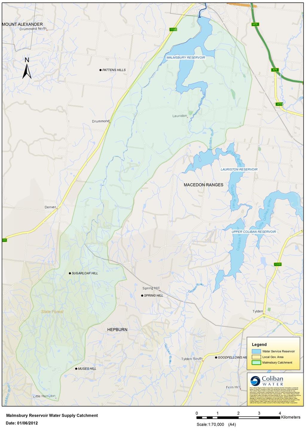
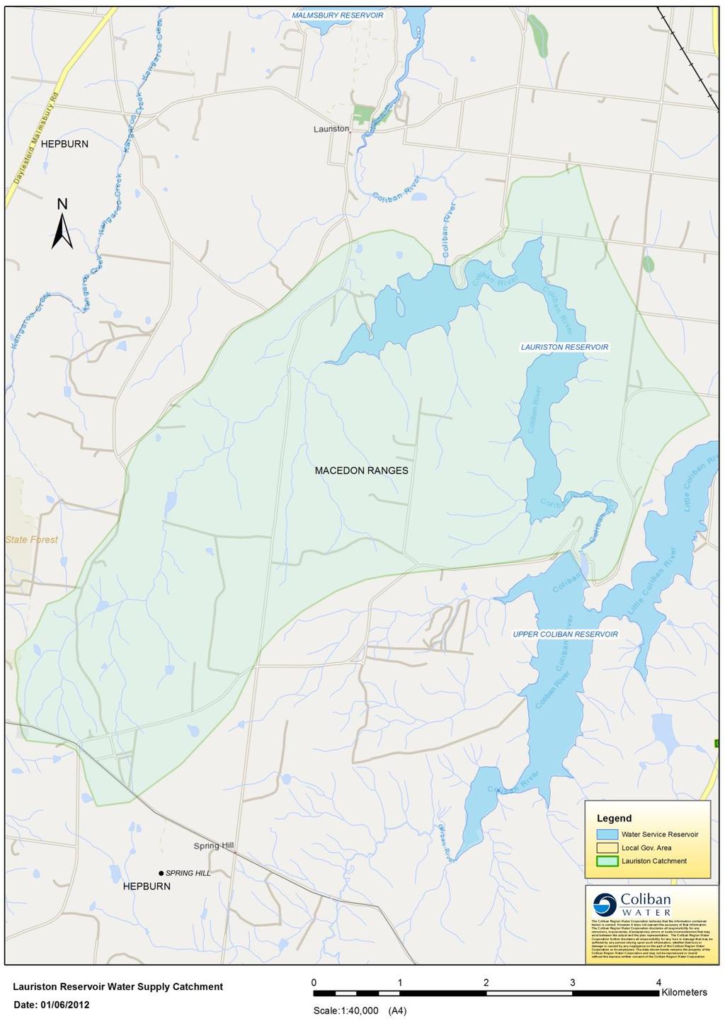
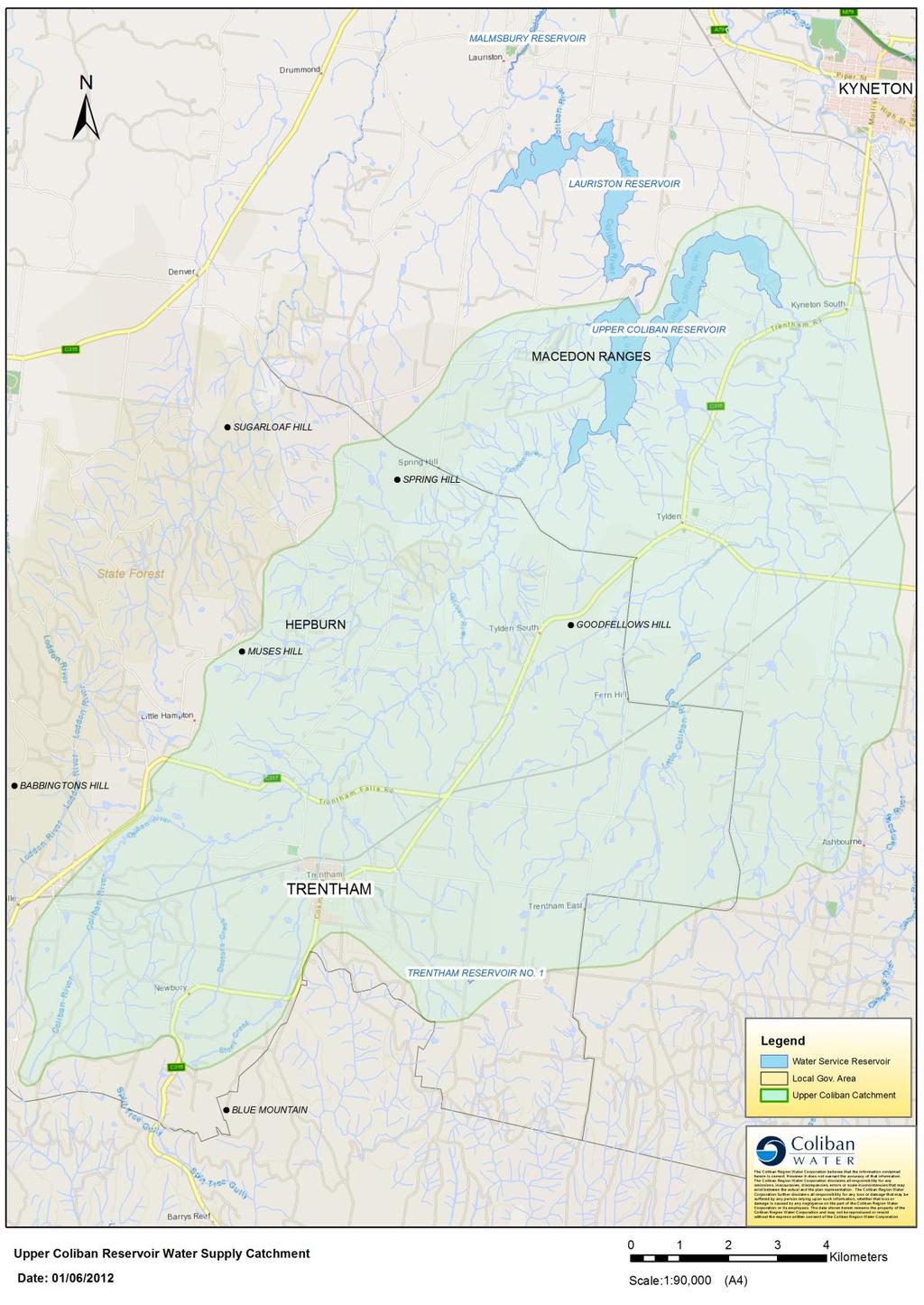
8 Annex 1 Catchment maps Page 8
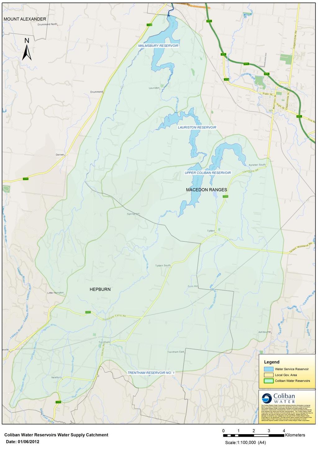
9 Page 9
10 Page 10
11 Page 11
12 Page 12

13 Annex 2 Institutional framework Page 13
S e c t i o n S u b d i vision
 S e c t i o n 2. 6 - S u b d i vision Subdivision is a process of defining and redefining land parcel boundaries and can provide a framework for future land use and development. Integrated, well planned
ON-SITE WASTEWATER MANAGEMENT POLICY
 ON-SITE WASTEWATER MANAGEMENT POLICY Responsible Department: Responsible Section: Responsible Officer: Planning and Development Strategy and Land Use Senior Health & Environmental Coordinator Objectives
Water Supply Catchment Development and Land Use Information
 A Tool for Assessing Planning Permit Applications in Water Supply Catchment Areas of SGW April 2018 Approved: 08/02/2016 Water Resources Page 1 of 20 Table of Contents 1 Definitions... 3 2 How to use this
Rural Residential Development Control Plan
 1 Rural Residential Development Control Plan Council of the City of Greater Lithgow 180 Mort Street, Lithgow NSW 2790 Telephone: (02) 6354 1077 2 EXPLANATORY NOTE: Council has been aware for some time
E1. Water quality and integrated management
 E1. Water quality and integrated management E1.1. Introduction The National Policy Statement for Freshwater Management, the New Zealand Coastal Policy Statement and this Plan seek to improve the integrated
Appendix E : Guidelines for Riparian Buffer Areas
 Appendix E : Guidelines for Riparian Buffer Areas This document should be read in conjunction with the CRCA Planning Policy. 1.0 PURPOSE The purpose of this document is to summarize the recommendations
Integrated Water Management Developer Guidance
 WESTERN WATER Western Water Whole-of-water-cycle Strategy Integrated Water Management Developer Guidance Edition 1, 2018 For more information call 1300 650 422 or visit us at WesternWater.com.au Development
SCHEDULE 4 TO CLAUSE THE SPECIAL USE ZONE. Shown on the planning scheme map as SUZ4. GOULBURN VALLEY HARNESS AND GREYHOUND RACING PRECINCT
 --/--/--- Proposed C199 SCHEDULE 4 TO CLAUSE 37.01 THE SPECIAL USE ZONE Shown on the planning scheme map as SUZ4. GOULBURN VALLEY HARNESS AND GREYHOUND RACING PRECINCT Purpose General To facilitate use,
beneficial management practices
 beneficial management practices introduction Phosphorus is an essential nutrient for crop growth. Alberta soils are generally deficient or low in phosphorus for optimum crop production (
Model Riparian Buffer Ordinance.
 Model Riparian Buffer Ordinance. This is a sample riparian buffer ordinance written as an amendment to an existing zoning ordinance. This ordinance complies with the state minimum standards for river corridor
SNOW REMOVAL & DISPOSAL POLICY
 PHILIP D. MURPHY Governor SHEILA Y. OLIVER Lt. Governor DEPARTMENT OF ENVIRONMENTAL PROTECTION Mail Code 401-02B Division of Water Quality 401 E State St P.O. Box 420 Trenton, NJ 08625-0420 CATHERINE R.
and the term landfill generically refers to all landfills, including the above types, unless specified otherwise.
 7 Landfills 7.1 Introduction Facilities for disposing of wastes to the ground have been variously described as landfills, tips, or dumps, without reference to the degree of environmental safeguards employed
WQMP AMENDMENT REVIEW CHECKLIST
 State of New Jersey Highlands Water Protection and Planning Council 100 North Road (Route 513) Chester, New Jersey 07930-2322 (908) 879-6737 (908) 879-4205 (fax) www.highlands.state.nj.us WQMP AMENDMENT
Wetland Design Manual. Supporting document: Planning, funding and. management
 Wetland Design Manual Supporting document: Planning, funding and management Contents Introduction... 2 Water Industry Act (1994)... 2 Water Act (1989)... 3 Planning and Environment Act (1987)... 3 Subdivisions
Connecting to Sydney Water systems. This policy applies to all customers who want to connect to or disconnect from Sydney Water s systems.
 Policy Connecting to Sydney Water systems 1. Overview 1.1 At a glance This policy explains: the services we offer customers when customers need permission to connect and disconnect requirements for connecting
subdivision BUSH LIVING ENVIRONMENT ASSESSMENT CRITERIA RULES
 RULES 10.0 General The following rules apply to Subdivision of land within the Bush Living Environment except that area identified as Titirangi Subdivision Area 1 and Titirangi-Laingholm Subdivision Area
14 NATURAL HAZARDS Background Resource Management Issues
 14 NATURAL HAZARDS 14.1 Background The particular geology, hydrology and topography of the Hutt Valley make Upper Hutt vulnerable to a variety of natural hazards. Earthquakes and flooding are the most
E2. Water quantity, allocation and use
 E2. Water quantity, allocation and use E2.1. Introduction E2 Water quantity, allocation and use Demand for water already equals or exceeds availability in some surface waterbodies and aquifers. Future
Overview and key environmental issues
 Blue Mountains Draft Local Environmental Plan 2013 1 Information Sheet 4 Overview and key environmental issues Use this document in conjunction with Information Sheet 5: SUBMISSION WRITING GUIDE AND SUMMARY
ENVIRONMENTAL GUIDELINES FOR PREPARATION OF AN ENVIRONMENT MANAGEMENT PLAN. Environment Protection Authority, ACT May 2009
 ENVIRONMENTAL GUIDELINES FOR PREPARATION OF AN ENVIRONMENT MANAGEMENT PLAN Environment Protection Authority, ACT May 2009 ISBN-13: 978-0-642-60494-1 ISBN-10: 0-642-60494-0 Australian Capital Territory,
Kaipara District Plan: Proposed Plan Change 2 - Fire Safety Rules SUMMARY
 Kaipara District Plan: Proposed Plan Change 2 - Fire Safety Rules SUMMARY Kaipara District Council is proposing changes to the Fire Safety Rules in the Kaipara District Plan. Research has been undertaken
PUTNAM COUNTY COMPREHENSIVE PLAN EXHIBIT DD INFRASTRUCTURE ELEMENT
 COMPREHENSIVE PLAN EXHIBIT DD D. Infrastructure Element (Sanitary Sewer, Potable Water, Solid Waste, Drainage and Natural Groundwater Aquifer Recharge) Goals, Objectives and Policies GOAL D.1: Putnam County
PART 5D - NATURAL HAZARDS
 CONTENTS...PAGE 5D.1 CONTENT AND STRUCTURE...3 5D.2 RESOURCE MANAGEMENT ISSUES...3 5D.3 RESOURCE MANAGEMENT OBJECTIVE AND POLICIES...4 5D.4 RESOURCE MANAGEMENT STRATEGY...4 5D.5 IMPLEMENTATION...4 5D.6.RULES
CONTROL OF ON-SITE WASTEWATER DISPOSAL SYSTEMS
 FAR NORTH DISTRICT COUNCIL BYLAWS CONTROL OF ON-SITE WASTEWATER DISPOSAL SYSTEMS To come into force: 1 July 2010 For the purpose of: Ensuring that all On-Site Wastewater Disposal Systems in operation or
ANCR INDIVIDUAL RESPONSES SUMMARY: 2/11/04 WATER RESOURCES GOALS AND OBJECTIVES
 ANCR INDIVIDUAL RESPONSES SUMMARY: 2/11/04 WATER RESOURCES GOALS AND OBJECTIVES Goal 1: Protect the health and safety of the Dane County population. a. Prevent development that may have an adverse effect
Environmental Guidelines for Preparation of an Environmental Management Plan
 2013 Environmental Guidelines for Preparation of an Environmental Management Plan Environmental Management Division Environmental Protection Agency 3/13/2013 ENVIRONMENTAL GUIDELINES FOR PREPARATION OF
RPE.3.4. Rural Production Environment. Index. RPE.1.1 Description and Expectations
 RPE.1 Index RPE.1 RPE.1.1 RPE.1.2 RPE.1.3 RPE.1.4 RPE.2 RPE.2.1 RPE.2.2 RPE.2.3 RPE.3 Landuse Description and Expectations Objectives Policies Guidance Note Eligibility Rules Notification Rules Discretionary
Works, services and infrastructure code
 9.4.11 Works, services infrastructure code 9.4.11.1 Application (1) This code applies to assessable development identified as requiring assessment against the Works, services infrastructure code by the
General A. General A.1 Activities Not Specifically Provided For A.2 Temporary Activities... 3
 Section Contents General... 2 4A. General... 2 4A.1 Activities Not Specifically Provided For... 2 4A.2 Temporary Activities... 3 4A.3 Activities on the Surface of Water... 6 4A.4 Status of Roads... 7 4A.5
9 OBJECTIVES/POLICIES: Hazardous Substances and Contaminated Land. 9. Hazardous Substances and Contaminated Land
 9. Hazardous Substances and Many activities in the District involve the use, storage, transportation and disposal of hazardous substances which are critical to manufacturing, construction, primary production
Greater Geelong City Council 10 December 2013 Minutes of Ordinary Meeting SECTION B - REPORTS Page 109
 Greater Geelong City Council 10 December 2013 Minutes of Ordinary Meeting SECTION B - REPORTS Page 109 8. LOW DENSITY RESIDENTIAL ZONE REVIEW Portfolio: Planning Cr Macdonald Source Economic Development,
Town of Eckville/Lacombe County INTERMUNICIPAL DEVELOPMENT PLAN DRAFT ADOPTED: INSERT DATE
 Town of Eckville/Lacombe County INTERMUNICIPAL DEVELOPMENT PLAN ADOPTED: INSERT DATE www.lacombecounty.com (403) 782-8389 planning@lacombecounty.com www.eckville.com (403) 746-2171 info@eckville.com For
City of Guelph Transfer of Review Procedures 7 March, 2017
 Step 1-Determine where the project is located on the City of Guelph Vulnerability Map If the project is found not to be located in a vulnerability area with a vulnerability score of 8 or higher (See Attachment
Stormwater Erosion Control & Post-Construction Plans (Stormwater Quality Plans)
") Stormwater Erosion Control & Post-Construction Plans (Stormwater Quality Plans) Allen County Stormwater Plan Submittal Checklist The following items must be provided when applying for an Allen County Stormwater
Stormwater Erosion Control & Post-Construction Plans (Stormwater Quality Plans) Allen County Stormwater Plan Submittal Checklist The following items must be provided when applying for an Allen County Stormwater
Support legislation that will protect the quantity of water in Lake Erie
 Specific Regional Priorities Each of Pennsylvania s major drainage basins has an array of individual characteristics that distinguish it from other regions of the state. These include diverse geographic
subdivision INFILL SUBDIVISION ASSESSMENT CRITERIA RULES
 Safety and Heritage RULES 3.0 General The following rules shall apply to the of land situated in the Living Environment where the is of existing sites either up to 1ha in net site area or which creates
GREATER DANDENONG PLANNING SCHEME AMENDMENT C201
 Planning and Environment Act 1987 GREATER DANDENONG PLANNING SCHEME AMENDMENT C201 Who is the planning authority? EXPLANATORY REPORT This amendment has been prepared by the City of Greater Dandenong who
Project A3.2 : Better Regulatory Frameworks Final Report : Results of Legislative Stock-take for Victoria
 1 Project A 3.2 Final Report : Results of Legislative Stock-take for Victoria Project A3.2 : Better Regulatory Frameworks Final Report : Results of Legislative Stock-take for Victoria December, 2013 Project
Part 8 Natural hazards
 Part 8 Natural hazards Contents Page 8.1 Introduction... 3 8.2 Resource management issue... 3 8.3 Objectives and policies... 3 8.4 Resource management strategy... 5 8.5 Rules - restricted discretionary
SUMMARY OF MAJOR POLICY IMPLEMENTATION TOPICS From 2016 COUNTY Comprehensive Plan
 SUMMARY OF MAJOR POLICY IMPLEMENTATION TOPICS From 2016 COUNTY Comprehensive Plan A checkmark means that implementing code amendments have been drafted or are in progress as of November 1, 2016. Evaluate
Chapter 3 Dispersion BMPs
 Chapter 3 Dispersion BMPs 3.1 BMP L611 Concentrated Flow Dispersion 3.1.1 Purpose and Definition Dispersion of concentrated flows from driveways or other pavement through a vegetated pervious area attenuates
ARMSTRONG CREEK EAST PRECINCT STRUCTURE PLAN ADVISORY COMMITTEE HEARING BALOG BROILER FARM. 84 Groves Road, Connewarre
 ARMSTRONG CREEK EAST PRECINCT STRUCTURE PLAN ADVISORY COMMITTEE HEARING BALOG BROILER FARM 84 Groves Road, Connewarre Land: Lot 2, Lodged Plan LP 210971 Part Crown Allotment 2 Section 4A Parish of Connewarre,
Manningham Works Code of Practice
 Manningham Works Code of Practice June 2017 Manningham City Council 699 Doncaster Road (PO Box 1) Doncaster Vic 3108 t 9840 9333 f 9848 3110 e manningham@manningham.vic.gov.au www.manningham.vic.gov.au
Site Plan and Subdivision Review
 Site Plan and Subdivision Review Municipal Land Use Framework Environmental Resource Inventory Master Plan Zoning Land Use Regulation Ordinance requirements for each zone Lot size, setbacks parking, cluster
Auckland Council Regional Plan: Air, Land and Water
 Auckland Council ISBN 1 877353 49 3 Auckland Council Regional Plan: Air, Land and Water OUR REGION, OUR FUTURE Auckland Regional Council Auckland Regional Plan: Air, Land and Water operative in part At
DOMESTIC WASTEWATER MANAGEMENT PLAN
 DOMESTIC WASTEWATER MANAGEMENT PLAN 2019-2024 2 Contents Executive Summary... 4 Introduction... 5 Risks associated with domestic wastewater... 9 Legislation and standards relevant to this DWMP... 10 DWMP
FORM B: ONSITE DISCHARGE OF TREATED EFFLUENT
 APPLICATION FOR RESOURCE CONSENT FORM B: ONSITE DISCHARGE OF TREATED EFFLUENT NOTES Resource use activities must meet all the conditions of any relevant Permitted Activity Rules in the Waikato Regional
Farmers rough guide to Environment Southland s rules
 Factsheet Farmers rough guide to Environment Southland s rules Updated April 2018 Agrichemicals (pesticides and herbicides) Discharge of agrichemicals onto or into surface water The substance must be approved
dairyshed effluent Western Australia Code of Practice for DAIRY Western Funded by Dairy Australia and your dairy service levy
 Code of Practice for dairyshed effluent Western Australia Funded by Dairy Australia and your dairy service levy Western DAIRY BACKGROUND The Western Australian dairy industry recognises the importance
TOWN OF SMYRNA Water Quality Buffer Zone Policy
 TOWN OF SMYRNA Water Quality Buffer Zone Policy Section I - Description A water quality buffer zone (a.k.a. a riparian zone) is a strip of undisturbed native (indigenous) vegetation, either original or
Town of Eckville/Lacombe County INTERMUNICIPAL DEVELOPMENT PLAN
 Town of Eckville/Lacombe County INTERMUNICIPAL DEVELOPMENT PLAN ADOPTED: APRIL 23, 2018 www.lacombecounty.com (403) 782-8389 planning@lacombecounty.com www.eckville.com (403) 746-2171 info@eckville.com
SECTION 3 NATURAL RESOURCES
 SECTION 3 NATURAL RESOURCES The natural environment plays a large role in planning for future development. Environmental conditions, such as topography, wetlands, floodplains, and water bodies, can often
The difficulties Maori can experience in expressing their cultural relationship with ancestral lands.
 OVERVIEW The Papakaianga Zone provides particular recognition and provision for the relationship of tangata whenua of Banks Peninsula with their ancestral lands. The term Papakaianga can mean original
7. Unreticulated Sewage Systems
 7. Unreticulated Sewage Systems 7.1 Issues A large portion of the region does not have a reticulated sewage system. Individuals disposing of their own domestic wastes can cause adverse effects. These effects
WATER SUPPLY POLICIES
 WATER SUPPLY POLICIES The County will: GOALS AND OBJECTIVES 10.1 Coordinate Planning Coordinate water supply planning with land use and wastewater management planning to assure that the supply and quality
Wakulla County Comprehensive Plan July 2013 GOALS, OBJECTIVES AND POLICIES
 GOALS, OBJECTIVES AND POLICIES INFRASTRUCTURE ELEMENT Goal 1: To provide needed public facilities in a manner that protects investments in existing facilities and supports orderly, efficient growth while
Infrastructure Element
 Infrastructure Element 1 2 3 4 5 6 7 8 9 10 11 12 13 14 15 16 17 18 19 20 21 22 23 24 25 26 27 28 29 30 31 32 33 34 35 36 37 38 39 40 41 42 43 44 45 INFRASTRUCTURE ELEMENT GOAL 1: To provide for environmentally
10.1 OBJECTIVES. Note: Refer to Section 6 for Issues, Methods of Implementation, and Environmental Results Anticipated.
 SECTION 10 : RURAL SETTLEMENTS Note: Refer to Section 6 for Issues, Methods of Implementation, and Environmental Results Anticipated. 10.1 OBJECTIVES The objectives contained in this section are specific
DRAFT NSW COASTAL PLANNING GUIDELINE: ADAPTING TO SEA LEVEL RISE SUBMISSION BY THE PLANNING INSTITUTE OF AUSTRALIA (PIA) DECEMBER 2009
 DECEMBER 2009") PO Box 484 North Sydney NSW 2059 T: 02 8904 1011 F: 02 8904 1133 E: nswmanager@planning.org.au DRAFT NSW COASTAL PLANNING GUIDELINE: ADAPTING TO SEA LEVEL RISE SUBMISSION BY THE PLANNING INSTITUTE OF AUSTRALIA
PO Box 484 North Sydney NSW 2059 T: 02 8904 1011 F: 02 8904 1133 E: nswmanager@planning.org.au DRAFT NSW COASTAL PLANNING GUIDELINE: ADAPTING TO SEA LEVEL RISE SUBMISSION BY THE PLANNING INSTITUTE OF AUSTRALIA
Morton West, Dacland. Hydrology / Stormwater Management Report Permit Application
 Morton West, Dacland Hydrology / Stormwater Management Report Permit Application February 2014 Document history Revision: Revision no. Author/s R01 Jonathon McLean Approved Jonathon McLean Distribution:
PROPOSED Plan Change 10: Lake Rotorua Nutrient Management COUNCIL DECISIONS. August 2017
 Version 8.0 August 2017 PROPOSED Plan Change 10: Lake Rotorua Nutrient Management COUNCIL DECISIONS Clear copy August 2017 This version shows the changes to the Proposed Plan Change 10 publicly notified
A 25 Year Strategic Plan
 A 25 Year Strategic Plan The challenges which face the provision of water services are identified as: Meeting Customer Needs at an Affordable Cost Providing Safe Water Supplies Managing Wastewater Protecting
CONSERVATION OF ENVIRONMENT ENACTMENT 1996 CONSERVATION OF ENVIRONMENT (PRESCRIBED ACTIVITIES) ORDER 1999
 ORDER 1999") (No. JPBN. 1509/27 Vol. II CONSERVATION OF ENVIRONMENT ENACTMENT 1996 CONSERVATION OF ENVIRONMENT (PRESCRIBED ACTIVITIES) ORDER 1999 In exercise of the powers conferred by section 5 of the Conservation
(No. JPBN. 1509/27 Vol. II CONSERVATION OF ENVIRONMENT ENACTMENT 1996 CONSERVATION OF ENVIRONMENT (PRESCRIBED ACTIVITIES) ORDER 1999 In exercise of the powers conferred by section 5 of the Conservation
Plan Review Background Paper Background Paper Number: 19 Planning & Development Department Date: September 2015
 Plan Review Background Paper Background Paper Number: 19 Planning & Development Department Date: September 2015 Environment Background East Hants is fortunate to enjoy the benefits of many natural resources
SCRCA SECTION 28 WETLAND POLICY
 April 21, 2016 SCRCA SECTION 28 WETLAND POLICY SCRCA Policies and Procedures of Administration of Section 28 Regulations Wetland Policies Definitions section (Source: Section 28 CA Act) Development means:
CORTLAND COUNTY HEALTH DEPARTMENT RULES AND REGULATIONS MINIMUM LOT SIZE
 CORTLAND COUNTY HEALTH DEPARTMENT RULES AND REGULATIONS MINIMUM LOT SIZE USE OF INDIVIDUAL WASTEWATER TREATMENT SYSTEMS AND DRINKING WATER SUPPLY WELLS WHERE PUBLIC FACILITIES ARE NOT AVAILABLE Approved
IOWA ADMINISTRATIVE CODE SUMMARY
 IOWA ADMINISTRATIVE CODE SUMMARY To explain and define details of legislation, departments in the executive branch of Iowa government adopt and publish rules. After prescribed public review and comments,
Chapter DRINKING WATER
 Whatcom County Code Chapter 24.11 DRINKING WATER Page 1 of 30 Sections: 24.11.010 Authority. 24.11.020 Purpose. 24.11.030 Adoption by reference. 24.11.040 Definitions. 24.11.050 General requirements. 24.11.060
County of Wetaskiwin Pigeon Lake Watershed Area Concept Plan February 6, 2014
 County of Wetaskiwin Pigeon Lake Watershed Area Concept Plan February 6, 2014 1 Introduction 1.1 Background The Pigeon Lake area continues to attract significant attention from landowners wanting to pursue
Natural Hazards Natural Hazards Explanatory Statement Significant Issues Objectives and Policies...
 Section Contents Natural Hazards... 2 8. Natural Hazards... 2 Explanatory Statement... 2 8.1 Significant Issues... 3 8.2 Objectives and Policies... 3 8.3 Activity Lists... 4 8.4 Matters of Control... 7
WESTERN REGIONAL WATER BALANCE
 WESTERN REGIONAL WATER BALANCE Greg Finlayson 1, Ryan Brotchie 1, Steven Roach 1, Lauren Mittiga 2, Abigail Farmer 3, John Chambers 3 1. GHD, Melbourne, VIC, Australia 2. Melbourne Water, Melbourne, VIC,
5.2 Discharges to water and land
 5.2 Discharges to water and land Interpretation If an activity is covered by more than one rule, then the rule that applies is the rule that is more specific for the relevant activity, area or resource,
INFRASTRUCTURE ELEMENT Goal, Objectives and Policies
 INFRASTRUCTURE ELEMENT Goal, Objectives and Policies City of Bartow Comprehensive Plan Adopted August 5, 1991 Amended August 2, 1993, Amended 1996 & 1999 Adopted Changes January 16, 2001, Amended April
I433. Pukekohe Hill Precinct
 I433. Pukekohe Hill Precinct I433.1. Precinct Description The Pukekohe Hill Precinct covers approximately 196 hectares of land and is located at the southern urban edge of Pukekohe. Land use, development
Summary of submissions to SDLs Issues Paper
 MURRAY-DARLING BASIN AUTHORITY Summary of submissions to SDLs Issues Paper Introduction In November 2009 the MDBA released a discussion paper inviting comments on issues around developing sustainable diversion
E36. Natural hazards and flooding
 E36. Natural hazards and flooding E36.1. Background Auckland is affected by natural hazards including: those that occur frequently such as flooding, coastal erosion (including the effects of sea level
Division 15 Earthworks Code (including Lot Filling)
") Division 15 Earthworks Code (including Lot Filling) 12.15.1 Earthworks Code (1) The provisions in this division comprise the (2) They are compliance with the Earthworks Code (Section 12.15.2); overall
Division 15 Earthworks Code (including Lot Filling) 12.15.1 Earthworks Code (1) The provisions in this division comprise the (2) They are compliance with the Earthworks Code (Section 12.15.2); overall
LAND LIMITATION ENVIRONMENTAL LIMITATIONS
 LAND LIMITATION ENVIRONMENTAL LIMITATIONS Floodplains An ideal municipal solid waste landfill will have little or no floodplain areas within its boundaries. A site located within the 100-year floodplain,
LESSER SLAVE RIVER AREA STRUCTURE PLAN
 IMPROVEMENT LESSER SLAVE RIVER AREA STRUCTURE PLAN DISTRICT NO 1 17 EAST Prepared by: Improvement District No. 17 East, and Planning Branch, Planning Services Division, Alberta Municipal Affairs Page 5.0
E36. Natural hazards and flooding
 E36. Natural hazards and flooding E36.1. Background Auckland is affected by natural hazards including: those that occur frequently such as flooding, coastal erosion (including the effects of sea level
D EROSION AND SEDIMENT CONTROL. Table of Contents
 Table of Contents D1. GENERAL... 1 D2. OBJECTIVE... 1 D3. REFERENCE MATERIAL... 1 D4. REGULATORY REQUIREMENTS... 1 D5. EROSION AND SEDIMENT CONTROL (ESC) PLANS... 2 D5.1 Goals and Objectives:... 2 D5.2
Division 8 Intensive Animal Husbandry Code
 Division 8 Intensive Animal Husbry Code 12.8.1 Intensive Animal Husbry Code (1) The provisions in this division comprise the Intensive Animal Husbry Code. (2) They are compliance with the Intensive Animal
LOCAL GOVERNMENT. General Government % %
 LOCAL GOVERNMENT General Government 1.4% 1.6% Operating costs for governance and corporate management as a percentage of total municipal operating costs. Efficient municipal government FIRE SERVICES Fire
DEKALB COUNTY STORMWATER MANAGEMENT PLAN PHASE 2
 DEKALB COUNTY STORMWATER MANAGEMENT PLAN PHASE 2 Introduction DeKalb County, Illinois, located approximately 50 miles west of Lake Michigan, is rectangular in shape, with a north/south dimension of 36
Characteristics of Land Resources
 Chapter Chapter 1 Characteristics of Land Resources The geology, soils and topography of Woodford County T he geology, soils and topography of an area are important to the community planning process for
Yuba County IRWMP 2015 UPDATE APPENDIX 10-1 General Plan Relation to IRWMP
 APPENDIX 10-1 General Plan Relation to IRWMP 1 of 13 Community Development Element Goal CD11: Quality of Life and Local Advantages Provide a high quality of life and take advantage of the County s economic
Rural Production Environment (RPE)
") 1 RPE.1 Rural Production Environment (RPE) RPE.1.1 Description & Expectations The Rural Production Environment (RPE) encompasses a large area of the Whangarei District. The Environment hosts a wide range
1 RPE.1 Rural Production Environment (RPE) RPE.1.1 Description & Expectations The Rural Production Environment (RPE) encompasses a large area of the Whangarei District. The Environment hosts a wide range
PART 8 SUBDIVISION. CITY OF AUCKLAND - DISTRICT PLAN HAURAKI GULF ISLANDS SECTION - OPERATIVE 1996 Page 1 updated 10/03/11
 PART 8 SUBDIVISION HAURAKI GULF ISLANDS SECTION - OPERATIVE 1996 Page 1 PART 8 - SUBDIVISION CONTENTS...PAGE 8.0 INTRODUCTION... 3 8.1 CONTENT AND STRUCTURE... 3 8.2 RESOURCE MANAGEMENT ISSUES... 4 8.3
Hazardous Substances. 9. Hazardous Substances. Explanatory Statement
 Hazardous Substances 9. Hazardous Substances Explanatory Statement The Western Bay of Plenty District is predominantly rural land in farming and horticulture and has a number of small urban centres containing
To understand how runoff water can be polluted if land uses are not properly managed
 Lesson plan - catchment land use impacts Objective To understand how runoff water can be polluted if land uses are not properly managed Materials Catchment land use impacts map (printed colour or black
Central Assiniboine and Lower Souris River Watershed. Public Consultation What you told us. June 2010
 Central Assiniboine and Lower Souris River Watershed Public Consultation What you told us June 2010 Table of Contents Introduction... 5 Methods... 5 Results of Public Consultation... 6 Individual Watershed
Pennichuck Brook Watershed Buildout Analysis December 2003
 INTRODUCTION The Pennichuck Brook watershed (Figure 1) includes approximately 17,700 acres within the communities of Amherst, Hollis, Merrimack, Milford and Nashua and is the primary drinking water supply
Thinking about developing or building on land with ponding or drainage issues?
 Thinking about developing or building on land with ponding or drainage issues? Much of the Kāpiti Coast is low-lying and subject to flooding, ponding or drainage issues. We need to pay careful attention
CEAA ENVIRONMENTAL ENVIRONMENTAL IMPACT ASSESSMENT AMBASSADOR BRIDGE ENHANCEMENT PROJECT. Replacement Span and Plaza Expansion APPENDIX E
 Ambassador Bridge Enhancement Project CEAA ENVIRONMENTAL ENVIRONMENTAL IMPACT ASSESSMENT AMBASSADOR BRIDGE ENHANCEMENT PROJECT Replacement Span and Plaza Expansion APPENDIX E DRAFT EROSION AND SEDIMENT
The approach to managing natural hazards in this Plan is to: set out a clear regional framework for natural hazard management,
 9 Natural Hazards 9.1 Scope and Background This chapter establishes an overall framework for natural hazard management under the RMA. It also sets out the division of responsibilities between the Regional
Promote fiscally responsible asset management of existing and proposed new infrastructure.
 10.0 Infrastructure Goals Promote fiscally responsible asset management of existing and proposed new infrastructure. Promote all sources of water as a valuable resource through the conservation of water,
ENVIRONMENTAL/SANITARY CODES OF JEFFERSON COUNTY, KANSAS CHAPTER II: WASTEWATER DISPOSAL
 ENVIRONMENTAL/SANITARY CODES OF JEFFERSON COUNTY, KANSAS CHAPTER II: WASTEWATER DISPOSAL SECTION 2-1.0 PURPOSE AND INTENT OF CODE: Domestic wastewater is a potential source of disease and water pollution,
14 NATURAL HAZARDS Background Resource Management Issues
 14 NATURAL HAZARDS 14.1 Background The particular geology, hydrology and topography of the Hutt Valley make Upper Hutt vulnerable to a variety of natural hazards. Earthquakes and flooding are the most
These potential changes and their implications are outlined in Annex 1.
 Guidance Note Hydropower Guidance Note: This Guidance Note has been prepared by Natural Resources Wales (NRW) to provide applicants for abstraction and impoundment licences for hydropower schemes with
INFRASTRUCTURE ELEMENT SANITARY SEWER SUB-ELEMENT
 INFRASTRUCTURE ELEMENT SANITARY SEWER SUB-ELEMENT GOALS, OBJECTIVES & POLICIES GOAL, OBJECTIVES & POLICIES GOAL SS. SANITARY SEWER PUBLIC SERVICE. It is the goal of the City of Casselberry to provide,