Xeneca Power Development Inc.
|
|
|
- Marian Carpenter
- 5 years ago
- Views:
Transcription

1 eneca Power Development Inc. Kapuskasing River Hydroelectric Project Rev. A November 2010
2 Disclaimer This report has been prepared by Hatch Ltd. for the sole and exclusive use of eneca Power Development Inc. (hereinafter referred to as eneca or the Proponent ) for the purpose of assisting the management of eneca in making decisions with respect to the proposed development of a waterpower project and shall not be (a) used for any other purpose, or (b) provided to, relied upon or used by any third party. This report contains opinions, conclusions and recommendations made by Hatch Ltd. (Hatch), using its professional judgment and reasonable care. Any use of or reliance upon this report and estimate by the Proponent is subject to the following conditions: the report being read in the context of and subject to the terms of the agreement between Hatch and eneca including any methodologies, procedures, techniques, assumptions and other relevant terms or conditions that were specified or agreed therein; the report being read as a whole, with sections or parts hereof read or relied upon in context; the conditions of the site may change over time (or may have already changed) due to natural forces or human intervention, and Hatch takes no responsibility for the impact that such changes may have on the accuracy or validity of the observations, conclusions and recommendations set out in this report; and the report is based on information made available to Hatch by eneca and/or by certain third parties; and unless stated otherwise in the Agreement, Hatch has not verified the accuracy, completeness or validity of such information, makes no representation regarding its accuracy and hereby disclaims any liability in connection therewith , Rev. A, Page i
3 Blank back , Rev. A, Page ii
4 Project Report eneca Power Development Inc. Kapuskasing River Hydroelectric Project November 3, 2010 DISTRIBUTION Canadian Environmental Assessment Agency Environment Canada Fisheries and Oceans Canada (DFO) Health Canada Indian and Northern Affairs Canada Transport Canada (TC) Infrastructure Canada Corporation of the Town of Kapuskasing Corporation of the Township of Chapleau Ministry of Aboriginal Affairs Ministry of Culture Ministry of Energy and Infrastructure Ministry of the Environment (MOE) Ministry of Natural Resources (MNR) Ministry of Transportation Ministry of Northern Development, Mines and Forestry Ontario Waterpower Association Table of Contents 1. General Information General Name and Proposed Location of Project Nature of the Project Purpose of the Project Economic Benefits of Project Parties who Received the Project Description Federal, Provincial and Municipal Agency and Stakeholder Consultations Other Environmental Assessment Processes Contacts Proponent and Contact Information Proponent s Consultant Land Ownership Authorizations Required Project Information Kapuskasing Lake Outlet Description of Proposed Project General Summary of Hydraulic Characteristics Installed Capacity Site Access Headworks Structures Conveyance System Powerhouse , Rev. A, Page iii
5 Transmission Area of Inundation Operating Strategy for Project Type of Proposed Project Operating Strategy Water Management Plan Lapinigam Rapids GS Description of Proposed Project General Summary of Hydraulic Characteristics Installed Capacity Site Access Headworks Structures Conveyance System Powerhouse Transmission Area of Inundation Operating Strategy for Project Type of Proposed Project Operating Strategy Water Management Plan Middle Township Buchan Description of Proposed Project General Summary of Hydraulic Characteristics Installed Capacity Site Access Headworks Structures Conveyance System Powerhouse Transmission Area of Inundation Operating Strategy for Project Type of Proposed Project Operating Strategy Water Management Plan Near North Boundary Description of Proposed Project General Summary of Hydraulic Characteristics Installed Capacity Site Access Headworks Structures Conveyance System Powerhouse Transmission Area of Inundation Operating Strategy for Project Type of Proposed Project Operating Strategy Water Management Plan , Rev. A, Page iv
6 2.5 Project Activities Construction Schedule and Activities Operation Decommissioning Resource Material Requirements Energy and Water Requirements and Sources Excavation and Quantity of Fill Toxic/Hazardous Materials Waste Disposal Project Site Information Project Location Natural Environmental Features Physical Environment Geology and Soils Surface Water Resources Biological Environment Fish and Fish Habitat Terrestrial Vegetation and Wildlife Species at Risk Provincially Significant Areas Socioeconomic Features Current and Past Land Uses Traditional Canoe and Fur Trade Route Forestry Hunting/Harvesting Mineral Resources Recreation/Tourism Potential Contamination of the Site from Past Uses Proximity to Aboriginal Reserves and Traditional Territory Proximity to Important or Designated Environmental or Cultural Sites Proximity to Residential and Other Urban Areas Additional Requirements Related to Fish, Fish Habitat and Navigable Waters Potential Effects to the Environment Zone of Influence Potential Effects to the Environment References Appendix A Appendix A1 Appendix A2 Appendix A3 Appendix A4 Appendix A5 Appendix B Conceptual Plates and Maps Kapuskasing River Projects Kapuskasing Lake Outlet Lapinigam Rapids Middle Township Buchan Near North Boundary Transmission Interconnection Baseline Environmental Field Investigations , Rev. A, Page v
7 List of Tables Table 1.1 Government Agencies and Organizations to be Contacted Table 1.2 Federal, Provincial and Municipal Approvals Table 3.1 Geographic Coordinates of Sites Table 3.2 Mean Monthly Water Flows Table 3.3 High and Low Flow Return Periods Flow Table 3.4 Fish Species of the Kapuskasing River (Hatch Acres, 2008) Table 3.5 Fish Catch Summary Table 5.1 Potential Effects Identification Matrix for Construction and Operation List of Figures Figure 1.1 Project Locations Figure 2.1 Outlet Kapuskasing Lake Photos Figure 2.2 Lapinigam Rapids (Buchan Falls) Photos Figure 2.3 Middle Township Buchan (Clouston Rapids) Photos Figure 2.4 Near North Boundary (Cedar Rapids) Photos , Rev. A, Page vi
8 1. General Information 1.1 General This has been prepared, based on the current conceptual design to meet the requirements of the Federal Canadian Environmental Assessment Act (CEAA) as well as the provincial Class Environmental Assessment for Waterpower Projects [Ontario Waterpower Association (OWA), 2008]. The current conceptual design is subject to change based on the results of studies, comment by Agencies, First Nation and Aboriginal Communities, and stakeholders Name and Proposed Location of Project The name of the project is the Kapuskasing River Hydroelectric Project. It consists of four proposed developments/sites on the Kapuskasing River between the Town of Elsas and the Town of Kapuskasing, being Kapuskasing Lake Outlet, Lapinigam Rapids (Buchan Falls), Middle Township Buchan (Clouston Rapids), and Near North Boundary (Cedar Rapids) Hydroelectric Generating Stations. Kapuskasing Lake Outlet is located on existing rapids or falls on the Kapuskasing River ±5 km downstream of Kapuskasing Lake. Lapinigam Rapids, Middle Township Buchan and Near North Boundary are all located on existing rapids or falls on the Kapuskasing River (Figure 1.1) Nature of the Project The Ministry of Natural Resources (MNR) released these sites as part of the Non-Competitive Site Release Package (CPR) Site ID Numbers 4LE03, 4LE05, 4LF09 and 4LE01. In response to the CRP, eneca Power Development Inc. submitted Waterpower Site Release Applications (WSR , WSR , WSR and WSR ) to the MNR on May 24, 2007 for Near North Boundary, May 31, 2007 for Kapuskasing Lake Outlet, and December 10, 2008 for Lapinigam Rapids and Middle Township Buchan. MNR acknowledged receipt of these applications on June 28, 2007 (Lapinigam Rapids and Middle Township Buchan), August 8, 2007 (Near North Boundary), and June 28, 2007 (Kapuskasing Lake Outlet). MNR has yet to forward Site Description Packages and award Applicant of Record Status for these sites to eneca Power Development. eneca Power was awarded Feed-In-Tariff (FIT) contracts for these sites on April 29, eneca Power is proposing to construct four hydroelectric facilities on the Kapuskasing River. The facilities will have a combined generating capacity of MW. With the exception of Kapuskasing Lake Outlet and Lapinigam Rapids which will have a spillway dam and an open approach channel to the powerhouse, each station will have water control structures (spillway and earth-fill dams) with attached powerhouses. A road upgrade and new roads will be required to access the site. A transmission line connecting at Weston Lake Distribution Station (DS) will be installed in order to connect the stations to the provincial power grid. The design information to date is based on the design, provided in the Site Development Plan and as revised up to the end of August Feasibility studies and field investigations will be required to optimize the design and it could be subject to change from that presented herein Purpose of the Project The purposes of the project are to , Rev. A, Page 1-1
9 meet government and energy regulatory agency goals and objectives to generate environmentally sustainable hydroelectric green power on a reliable basis sell the generated power under a FIT electricity contract from the Ontario Power Authority (OPA). To meet these objectives, eneca Power will try to maximize the use of existing infrastructure to connect to the existing distribution grid and to the provincial power grid Economic Benefits of Project The proposed Kapuskasing River Hydroelectric Project will have a total installed capacity of approximately 19.5 MW. Waterpower creates jobs, generates revenue to the taxpayers of Ontario and is the longest lived and most reliable source of clean, renewable electricity. Approximate economic activity (direct) to build in Ontario is $5 million per megawatt, about half of which is spent locally procuring everything from consulting and legal services to concrete, steel, trucking and other services such as hotels, restaurant and fuel. Direct job creation (construction only) 10,000 person hours per MW. Indirect jobs multiply by 1.5. Local/Regional economic boost of $2.5 million per MW about $12 million. First Nations and non aboriginal community participation incentives. For overview see eneca Website. Significant return to the people of Ontario with approximately $5 million per MW ($24 million over the 40-yr lifespan of the project) paid through Gross Revenue Charges (GRC) and Provincial and Federal Income taxes. May assist mining companies or local industry by providing more reliable power with some potential cost savings. Waterpower lasts: many power plants built in the early 1900s are still in operation and with regular maintenance and upgrades can last for generations to come. In comparison the life span for other sources of clean power are: nuclear 40 years, wind 20 years, solar 20 years Parties who Received the Project Description This has been submitted to the Canadian Environmental Assessment Agency (CEA Agency) in Toronto for distribution to relevant federal agencies including: Fisheries and Oceans Canada (DFO), Environment Canada (EC), Health Canada (HC), Transport Canada (TC), Indian and Northern Affairs Canada (INAC) and any other agencies deemed relevant by the CEA Agency. The will also be submitted to the MNR Hearst District and Chapleau District, Ontario Ministry of the Environment (MOE) (Thunder Bay Northern Region and Timmins District), the Ontario Ministry of Culture (MOC), the Town of Kapuskasing and the Township of Chapleau. In addition, the Project Description will be provided to the First Nation and Aboriginal Communities listed in Table , Rev. A, Page 1-2

10 CA 11!( Kapuskasing 11 CA 12 CA 13 Cargill Rd. CP 3 SPUR CA 14 CA 15 CP 15 Access Rd Swanson Rd Graveyard Creek DION ROAD Kapuskasing River CP 36 HAUL ROAD CA 9 Cedar Rapids Clouston Rapids Chain of Lakes Rd Legend Roads Railroads Dunrankin River Buchan Falls BUCHANAN ROAD Watercourse Km 1:250,000 N Outlet Rapids Elsas Figure 1.1 eneca Power Inc. Kapuskasing River Project Project Locations
11 Back of figure , Rev. A, Page 1-4
12 1.1.6 Federal, Provincial and Municipal Agency and Stakeholder Consultations The agencies and organizations shown in Table 1.1 are among the entities to be consulted for this environmental screening/owa Class Environmental Assessment (EA). All the agencies and stakeholders listed in Table 1.1 will be sent an introductory letter and copy of the Notice of Commencement Other Environmental Assessment Processes This project is subject to the Class EA for Waterpower Projects (OWA, 2008), which is an approved Class EA under the Ontario Environmental Assessment Act. The project is considered to be a new project on a managed waterway and will be assessed in accordance with the OWA Class EA requirements for such a designation. Table 1.1 Government Agencies and Organizations to be Contacted Federal Government Canadian Environmental Assessment Agency Environment Canada Fisheries and Oceans Canada (DFO) Health Canada Indian and Northern Affairs Canada Transport Canada (TC) Infrastructure Canada Provincial Government Ministry of Aboriginal Affairs Ministry of Culture Ministry of Energy and Infrastructure Ministry of the Environment (MOE) Ministry of Natural Resources (MNR) Ministry of Transportation Ministry of Northern Development, Mines and Forestry Municipal Government Corporation of the Township of Chapleau Corporation of the Town of Kapuskasing First Nations Brunswick House First Nation (Dusk Lake and Mountbatten) Flying Post First Nation Chapleau Cree First Nation Chapleau Ojibway First Nation Moose Cree First Nation Taykwa Tagamou First Nation Metis Nations of Ontario Michipicoten First Nation Missinabie Cree First Nation Constance Lake First Nation Wabun Tribal Council Mushkegowuk Council Kapuskasing Indian Friendship Centre Métis Nation of Ontario , Rev. A, Page 1-5
13 Non-Governmental Agencies/Associations Air Ivanhoe Canadian Parks and Wilderness Society Canadian Recreational Canoeing Association Club Autoneige Les Grondeurs Snowmobile Club Federation of Ontario Naturalists Gosenda Lodge Hike Ontario Kap Rod & Gun Club Kap Trapshooters Association Kap Sno-Rovers Kapuskasing Nordic Skiers Northern Corridor Du Nord Snowmobile Association Northern Ontario Tourist Outfitters Association Northwatch Ontario Recreational Canoeing Association Ontario Tourism Outfitters Partnership for Public Lands Prospectors and Developers Association of Canada Whitewater Ontario Wilderness Canoe Association Industry/Commercial Stakeholders Agrium Mine Tembec Spruce Falls Inc. Hydro One Networks Inc. Canadian National Railway Boreal Guiding Services Ontario Fishing and Hunting Adventures Ontario Waterpower Association eneca Power Development Inc. - Kapuskasing River Hydroelectric Project 1.2 Contacts Proponent and Contact Information The project proponent is eneca Power Development Inc. There are no co-proponents involved in this project. Contact information for eneca Power Development Inc. is as follows: Patrick Gillette President eneca Power Development Inc Yonge Street #520 North York, ON M2N 6L9 Phone: Fax: pgillette@xeneca.com Proponent s Consultant Hatch Ltd. (Hatch) has been retained to conduct field study program and the Class EA for this project. Contact information for Hatch is as follows: , Rev. A, Page 1-6
14 Larry King Hatch Ltd 4342 Queen Street, Suite 500 Niagara Falls, Ontario L2E 7J7 Phone: Fax: Land Ownership The land to be used by the project, i.e. for the generating stations, head ponds, switchyards, control structures, access roads and transmission line corridors, is provincial Crown lands and private land. All land on the west side of the river and land surrounding the Kapuskasing Lake Outlet site is Crown land. All land on the east side of the river from the northern extent of Allenby Township to the southern extent of Davin Township is privately owned by Tembec, with the exception of a 200 m allowance along the shoreline that is owned by the Crown. As such, all four sites (Kapuskasing Lake Outlet, Lapinigam Rapids, Middle Township Buchan, and Near North Boundary) will be built on provincial Crown lands. Transmission lines and access roads for the three northern sites will initially be on private lands, transitioning to public lands beyond the eastern limit of Tembec s lands. 1.4 Authorizations Required Table 1.2 outlines the potential federal, provincial and municipal permits and approvals that might be required. A list of all actually required permits will be developed once the Detailed Design and Construction Plan is available. Table 1.2 Federal, Provincial and Municipal Approvals Permit and Legislative Requirement Federal Authorization for Works and Undertakings Affecting Fish Habitat Fisheries Act [Section 35(2)] Authorization for Destruction of Fish by Means other than Fishing Fisheries Act (Section 32) Approval for Construction in Navigable Waters Navigable Waters Protection Act (Section 5) Provincial Lakes and Rivers Improvement Act (LRIA) Location Approval and Plans and Specifications Approval Water Management Plan Cultural Heritage Clearance Phase 1 Archaeological Assessment Permit to Take Water Ontario Water Resources Act (Section 34) Certificate of Approval (Industrial Sewage) Ontario Water Resources Act (Section 53) Agency Department of Fisheries and Oceans Department of Fisheries and Oceans Transport Canada (Marine) Ministry of Natural Resources Ministry of Natural Resources Ministry of Culture Ministry of Environment Ministry of Environment , Rev. A, Page 1-7
15 Permit and Legislative Requirement Certificate of Approval (Air and Noise) Environmental Protection Act (Section 9) Waste Generator Registration Environmental Protection Act [Section 18(1)], Ontario Regulation 347 Notice of Project and Registration of Contractors Construction Regulation 213/91 Other Road Use Agreement Agency Ministry of Environment Ministry of Environment Ministry of Labour Tembec Spruce Falls An authorization from DFO under the Fisheries Act and approval from Transport Canada (Marine) under the Navigable Waters Protection Act (NWPA) will likely be required. Either will trigger the need for an environmental assessment under CEAA. Since the proposed project is less than 200 MW, a screening level environmental assessment would be completed in accordance with CEAA and appropriate guidelines , Rev. A, Page 1-8
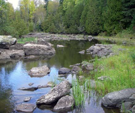
16 2. Project Information 2.1 Kapuskasing Lake Outlet Description of Proposed Project General The proposed project at Kapuskasing Lake Outlet would capture the surveyed gross head of 6.5 m. The conceptual development incorporates the use of a dam/weir. A conveyance channel situated on the east shore of the river will conduct flow from the river to an intake which will feeds one 2.5-MW Kaplan turbine (Appendix A1, Plate 1). The general arrangement and photographs of the river within the proposed head pond are shown in Figure 2.1. Further details of the power facilities are presented on successive plates in Appendix A1, and the extent of the lands involved in the development is also shown on the plates. The proposed site development is described in more detail in the following sections. Design is subject to change to factor in improvements based on the results of studies and comments from Agencies, First Nation Communities, Aboriginal Communities and, stakeholders. Changes may result from assessment of environmental, social or economic factors Summary of Hydraulic Characteristics Estimated existing water levels: normal operating headwater level el 312 m normal tailwater level downstream of powerhouse el m normal operating gross head 6.5 m 1:100-yr flood flow 426 m 3 /s 1:100-yr low flow 1.2 m 3 /s long-term average flow 35.9 m 3 /s Installed Capacity The installed capacity at this site will be a single unit of 2.5 MW Site Access The proposed site access will require a 6-km long road to be built off an existing road located east of the project (Appendix A1, Outlet Kapuskasing GS, Lines and Roads Map) Headworks Structures Plates 1 to 3 (Appendix A1) show the general layout and details of the flow control structures. There is a single dam incorporating a 10-m long side abutment, an 85-m long concrete spillway, a 62-m long central abutment and a 16-m wide intake structure , Rev. A, Page 2-1
17 Conveyance System There is a 450-m open approach channel to the powerhouse. A plan and profile of the conveyance system is shown on Plate 3 (Appendix A1) Powerhouse The powerhouse footprint will be approximately 31 m long by 10 m wide. Plate 4 in Appendix A1 shows the plan and a cross-sectional profile of the powerhouse Transmission A new 44-kV line will run to the Middle Township Buchan site from the Kapuskasing Lake Outlet site (see Appendix A1, Outlet Kapuskasing GS, Lines and Roads Map). From the Middle Township Buchan site, a common 44 or 115-kV line will connect to the Ivanhoe River Third Falls Line, and subsequently to the Weston Lake DS, then onward to Circuit T61S, Tower 217 (Appendix A5, Kapuskasing/Ivanhoe to Point of Connection, Lines and Roads Map) Area of Inundation Approximately 1.3 ha of additional area will be inundated behind the dam (Appendix A1, Plate 5) Operating Strategy for Project Type of Proposed Project The proposed development will be operated as a run-of-river with modified peaking [as defined by Ministry of Energy and Infrastructure (MEI), 2010]. As per the MEI website, a run-of-river with modified peaking is a plant which allows for limited storage of water to produce more electricity during periods of high demand and save water during periods of low demand for use at a later time Operating Strategy eneca proposes to operate based on the natural run of water upstream of the plant with some daily flow modifications. The OPA FIT program encourages power to be produced during daytime hours when Ontario households use power most. To this end, and where circumstances permit, some electricity production may be shifted from night time and weekend hours to daytime hours on weekdays. No long-term storage of water is proposed. The MEI refers to this operation mode as run-of-river with modified peaking. Most of the yearly production will occur round the clock. Production shifting will occur during periods of low flow when the natural run in the river drops below the plant capacity. These conditions occur predominantly in late summer and late winter. The amount of water that can be stored is limited by the amount of natural storage available and based on acceptable fluctuation of water levels upstream and minimum flow requirements downstream of the plant. Details of the operation will be determined during the Waterpower Class EA based on environmental, stakeholder and economic constraints specific to the project , Rev. A, Page 2-2


18 H/335434_Oct_27_2010_rm Photo 1 Photo 6 Proposed Powerhouse Photo 2 Proposed Channel Proposed Channel Intake Structure Proposed Spillway and Dam Photo Photo Photo 8 Photo 4 Photo 9 Photo 5
19 Blank back , Rev. A, Page 2-4
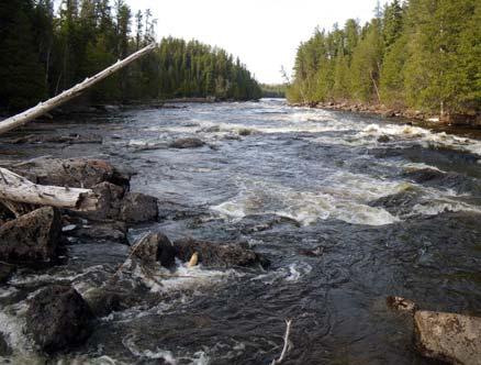
20 Water Management Plan An amendment to the Mattagami River Water Management Plan (WMP) will be required before the station commences operation. Current waterpower operators within this plan include Ontario Power Generation generating stations on the Mattagami River and the Tembec Spruce Falls Inc. facility (dam and generating station) in Kapuskasing as well as the pending Hydromega generating stations downstream of the project. 2.2 Lapinigam Rapids GS Description of Proposed Project General The proposed Lapinigam Rapids GS would capture the surveyed gross head of 19 m. The conceptual development incorporates the use of a spillway dam and an open approach to a powerhouse at the base of the falls on the east bank (Appendix A2, Plate 5). A penstock leading from the open channel to the powerhouse will conduct flows from the river to a single Kaplan turbine with a nameplate rating of 8.2 MW. The general arrangement and photographs of the river within the proposed head pond are shown in Figure 2.2. Further details of the power facility are presented on successive plates in Appendix A2, and the extent of the lands involved in the development is also shown on the plates. The proposed site development is described in more detail in the following sections. Design is subject to change to factor in improvements based on the results of studies and comments from Agencies, First Nation Communities, Aboriginal Communities and, stakeholders. Changes may result from assessment of environmental, social or economic factors Summary of Hydraulic Characteristics Estimated existing water levels maximum headwater level (1:100-yr flood) el m normal operating headwater level el m normal tailwater level downstream of powerhouse el m normal operating gross head 20 m 1:100-yr flood flow 38 m 3 /s 1:100-yr low flow 1.2 m 3 /s long-term average flow 37 m 3 /s Installed Capacity The installed capacity at this site will be a single unit of 8.2 MW , Rev. A, Page 2-5
21 Site Access The proposed access road will be approximately 9 km long, extending to the site from the end of Buchanan Road (Appendix A2, Lapinigam Rapids GS, Lines and Roads Map) Headworks Structures The headworks will include a 125-m long spillway dam and a 23-m wide intake structure that leads into the open channel to the powerhouse (Appendix A2, Plate 6) Conveyance System A 460-m long open approach channel will convey water to a 65-m long penstock attached to the powerhouse (Appendix A2, Plate 7) Powerhouse The powerhouse footprint will be approximately 35 m long by 14 m wide. Plate 8 (Appendix A2) shows the plan and a cross-sectional profile of the powerhouse Transmission A new 44-kV line will run to the Middle Township Buchan site from the Lapinigam Rapids site (see Appendix A2, Lapinigam Rapids GS, Lines and Roads Map). From the Middle Township Buchan site, a common 44 or 115-kV line will connect to the Ivanhoe River Third Falls Line, and subsequently to the Weston Lake DS, then onward to Circuit T61S, Tower 217 (Appendix A5, Kapuskasing/Ivanhoe to Point of Connection, Lines and Roads Map) Area of Inundation In normal operating levels, approximately 6.3 ha of additional area will be flooded behind the dam (Appendix A2, Plate 11) Operating Strategy for Project Type of Proposed Project The proposed development will be operated as a run-of-river with modified peaking (as defined by MEI, 2010). As per the MEI website, a run-of-river with modified peaking is a plant which allows for limited storage of water to produce more electricity during periods of high demand and save water during periods of low demand for use at a later time Operating Strategy eneca proposes to operate based on the natural run of water upstream of the plant with some daily flow modifications. The OPA FIT program encourages power to be produced during daytime hours when Ontario households use power most. To this end, and where circumstances permit, some electricity production may be shifted from night time and weekend hours to daytime hours on weekdays. No long-term storage of water is proposed. The MEI refers to this operation mode as run-of-river with modified peaking. Most of the yearly production will occur round the clock. Production shifting will occur during periods of low flow when the natural run in the river drops below the plant , Rev. A, Page 2-6


22 H/335434_Oct_27_2010_rm Photo 1 Photo 2 Proposed Powerhouse Intake Canal 4 5 Photo Photo 5 Proposed Spillway and Dam Photo 4 Photo 6 Photo 8 9 Upper Extent of Headpond Photo 7 Photo 9
23 Back of figure , Rev. A, Page 2-8
24 capacity. These conditions occur predominantly in late summer and late winter. The amount of water that can be stored is limited by the amount of natural storage available and based on acceptable fluctuation of water levels upstream and minimum flow requirements downstream of the plant. Details of the operation will be determined during the Waterpower Class EA based on environmental, stakeholder and economic constraints specific to the project Water Management Plan An amendment to the Mattagami River WMP will be required before the station commences operation. Current waterpower operators within this plan include Ontario Power Generation generating stations on the Mattagami River and the Tembec Spruce Falls Inc. facility (dam and generating station) in Kapuskasing as well as the pending Hydromega generating stations downstream of the project. 2.3 Middle Township Buchan Description of Proposed Project General The proposed Middle Township Buchan GS would capture the surveyed gross head of 13 m. The conceptual development incorporates the use of a dam/weir with a close-coupled powerhouse that contains one 5-MW Kaplan turbine (Appendix A3, Plate 1). The general arrangement and photographs of the river within the proposed head pond are shown in Figure 2.3. Further details of the power facilities are presented on successive plates in Appendix A3, and the extent of the lands involved in the development is also shown on the plates. The proposed site development is described in more detail in the following sections. Design is subject to change to factor in improvements based on the results of studies and comments from Agencies, First Nation Communities, Aboriginal Communities and, stakeholders. Changes may result from assessment of environmental, social or economic factors Summary of Hydraulic Characteristics Estimated existing water levels normal operating headwater level el 274 m normal tailwater level downstream of powerhouse el m normal operating gross head 13.5 m 1:100-yr flood flow 441 m 3 /s 1:100-yr low flow 1.24 m 3 /s long-term average flow 37.1 m 3 /s Installed Capacity The installed capacity at this site will be a single unit of 5.0 MW , Rev. A, Page 2-9
25 Site Access The proposed site access will be approximately 7 km long, connecting with the existing Buchanan Road (Appendix A3, Middle Township Buchan GS, Lines and Roads Map) Headworks Structures Plates 1 and 2 (Appendix A3) show the layout and details of the flow control structures. There is a single dam incorporating a 46-m long earth-filled abutment, the powerhouse and a 90-m long roller compacted concrete (RCC) spillway section Conveyance System Within the head-pond limits, the area in front of the intake will be deepened to improve flow to the powerhouse. A tailrace channel will be excavated below the powerhouse to return water from the powerhouse to the river Powerhouse The powerhouse footprint will be approximately 35 m long by 13 m wide. Plate 3 in Appendix A3 shows the plan and a cross-sectional profile of the powerhouse Transmission All 44-kV feeder lines from other sites will converge at this location (Appendix A3, Middle Township Buchan GS, Lines and Roads Map). From the Middle Township Buchan site, a common 44 or 115-kV line will connect to the Ivanhoe River Third Falls Line, and subsequently to the Weston Lake DS, then onward to Circuit T61S, Tower 217 (Appendix A5, Kapuskasing/Ivanhoe to Point of Connection, Lines and Roads Map) Area of Inundation Approximately 12.4 ha of additional area will be inundated behind the dam (Appendix A3, Plate 6) Operating Strategy for Project Type of Proposed Project The proposed development will be operated as a run-of-river with modified peaking (as defined by MEI, 2010). As per the MEI website, a run-of-river with modified peaking is a plant which allows for limited storage of water to produce more electricity during periods of high demand and save water during periods of low demand for use at a later time Operating Strategy eneca proposes to operate based on the natural run of water upstream of the plant with some daily flow modifications. The OPA FIT program encourages power to be produced during daytime hours when Ontario households use power most. To this end, and where circumstances permit, some electricity production may be shifted from night time and weekend hours to daytime hours on weekdays. No long-term storage of water is proposed. The MEI refers to this operation mode as run-of-river with modified peaking. Most of the yearly production will occur round the clock. Production shifting , Rev. A, Page 2-10


26 H/335434_Oct_27_2010_rm 1 Photo 1 2 Photo 2 Photo 3 Photo 4 Photo 5 Photo 6 Photo Proposed Spillway and Dam 5 Proposed Powerhouse 6 Proposed Earth-filled Dam Photo Photo 12 Photo 9 14 Photo 13 Photo 10 Photo Photo 14 Photo 15 Upper Extent of Headpond Photo 16 16
27 Back of figure , Rev. A, Page 2-12
28 will occur during periods of low flow when the natural run in the river drops below the plant capacity. These conditions occur predominantly in late summer and late winter. The amount of water that can be stored is limited by the amount of natural storage available and based on acceptable fluctuation of water levels upstream and minimum flow requirements downstream of the plant. Details of the operation will be determined during the Waterpower Class EA based on environmental, stakeholder and economic constraints specific to the project Water Management Plan An amendment to the Mattagami River WMP will be required before the station commences operation. Current waterpower operators within this plan include Ontario Power Generation generating stations on the Mattagami River and the Tembec Spruce Falls Inc. facility (dam and generating station) in Kapuskasing as well as the pending Hydromega generating stations downstream of the project. 2.4 Near North Boundary Description of Proposed Project General The proposed project at Near North Boundary would capture the surveyed gross head of 9 m. The conceptual development incorporates the use of a dam/weir. The powerhouse is attached to the dam. It contains one Kaplan turbine with a nameplate rating of 3.75 MW (Appendix A4, Plate 1). The general arrangement and photographs of river within the proposed head pond are shown in Figure 2.4. Further details of the power facilities are presented on successive plates found in Appendix A4. The extent of the lands involved in the development is also shown on the plates. The proposed site development is described in more detail in the following sections. Design is subject to change to factor in improvements based on the results of studies and comments from Agencies, First Nation Communities, Aboriginal Communities and, stakeholders. Changes may result from assessment of environmental, social or economic factors Summary of Hydraulic Characteristics Estimated existing water levels normal operating headwater level el 259 m normal tailwater level downstream of powerhouse el 250 m normal operating gross head 9 m 1:100-yr flood flow 529 m 3 /s 1:100-yr low flow 1.5 m 3 /s long-term average flow 44.6 m 3 /s Installed Capacity The installed capacity at this site will be a single unit of 3.75 MW , Rev. A, Page 2-13
29 Site Access The proposed site access will be approximately 7 km long, intersecting the new road from Middle Township Buchan approximately one third along its length to its connection with the existing Buchanan Road (Appendix A4, Near North Boundary GS, Lines and Roads Map) Headworks Structures Plates 1 and 2 (Appendix A4) show the layout and details of the water control structures. There is a single dam incorporating a 23-m long earth-filled abutment, a 95-m long spillway section and powerhouse. (Appendix A4, Plates 1 and 2) Conveyance System Within the head-pond limits, the area in front of the intake will be deepened to improve flow to the powerhouse. A tailrace channel will be excavated below the powerhouse to return water from the powerhouse to the river Powerhouse The powerhouse footprint will be approximately 35 m long by 10 m wide. Its intake will be approximately 11.6 m wide and 3.9 m deep. Plate 3 shows a cross-sectional profile of the powerhouse and spillway (Appendix A4, Plate 3) Transmission A new 44-kV line will run to the Middle Township Buchan site from the Near North Boundary site (Appendix A4, Near North Boundary GS, Lines and Roads Map). From the Middle Township Buchan site, a common 44 or 115-kV line will connect to the Ivanhoe River Third Falls Line, and subsequently to the Weston Lake DS, then onward to Circuit T61S, Tower 217 (Appendix A5, Kapuskasing/Ivanhoe to Point of Connection, Lines and Roads Map) Area of Inundation Approximately 1.6 ha of additional area will be inundated behind the dam (Appendix A4, Plate 6) Operating Strategy for Project Type of Proposed Project The proposed development will be operated as a run-of-river with modified peaking (as defined by MEI, 2010). As per the MEI website, a run-of-river with modified peaking is a plant which allows for limited storage of water to produce more electricity during periods of high demand and save water during periods of low demand for use at a later time Operating Strategy eneca proposes to operate based on the natural run of water upstream of the plant with some daily flow modifications. The OPA FIT program encourages power to be produced during daytime hours when Ontario households use power most. To this end, and where circumstances permit, some electricity production may be shifted from night time and weekend hours to daytime hours on weekdays. No , Rev. A, Page 2-14


30 H/335434_Oct_27_2010_rm 1 Photo 1 2 Photo 2 Proposed Powerhouse 3 Proposed Earth-filled Dam 4 Photo 3 Proposed Spillway and Dam 5 Photo 4 Photo 5 6 Photo 6 Photo Photo 9 Photo 8 Upper Extent of Headpond 10 Photo 10
31 Blank back , Rev. A, Page 2-16
32 long-term storage of water is proposed. The MEI refers to this operation mode as run-of-river with modified peaking. Most of the yearly production will occur round the clock. Production shifting will occur during periods of low flow when the natural run in the river drops below the plant capacity. These conditions occur predominantly in late summer and late winter. The amount of water that can be stored is limited by the amount of natural storage available and based on acceptable fluctuation of water levels upstream and minimum flow requirements downstream of the plant. Details of the operation will be determined during the Waterpower Class EA based on environmental, stakeholder and economic constraints specific to the project Water Management Plan An amendment to the Mattagami River WMP will be required before the station commences operation. Current waterpower operators within this plan include Ontario Power Generation generating stations on the Mattagami River and the Tembec Spruce Falls Inc. facility (dam and generating station) in Kapuskasing as well as the pending Hydromega generating stations downstream of the project. 2.5 Project Activities Construction Schedule and Activities Construction of the proposed facilities is scheduled to take place between 2013 and Operation The facilities will operate as a run-of-river with limited daily peaking facility. The facility will be designed with the capacity to be remotely operated in addition to having on-site controls. Typically, hydroelectric projects are designed for a 50 to 100-yr lifespan. Upgrades and rehabilitation activities may extend their useful life Decommissioning There are no present plans for decommissioning of the facilities. The decision on decommissioning (or alternatively upgrading or rehabilitation to extend facility life) would depend on the structure/ historic attributes of the facility as well as economic and other considerations at the time. The responsibility of decommissioning will be undertaken by the current owner at such a time as the facility is deemed no longer useful. At such time the decommissioning will be completed according to the legal requirements of regulatory body responsible for it at that time. 2.6 Resource Material Requirements Energy and Water Requirements and Sources On-site energy requirements during construction are likely to be provided by portable diesel generators. Operational energy requirements for the facility will be supplied via a return distribution line from the interconnection point. A back-up diesel generator will likely be installed on site to provide emergency power to the facility during power outages. On-site water requirements for construction are not known at the present time, although it is likely the water will be required during the construction process (i.e., concrete mixing, wash water, etc) , Rev. A, Page 2-17
33 This water may be supplied from the Kapuskasing River via portable pumps. The quantities required are anticipated to be small and will not require a Permit to Take Water (PTTW) from MOE as the taking will be much less than the 50,000 L/d threshold. Construction process water might also be trucked in from outside sources if required. Operational water requirements for the facility are not known at this time. Small amounts of cooling water may be withdrawn from the Kapuskasing River to cool powerhouse components. A PTTW will be obtained if the amount required exceeds the PTTW threshold. There will not likely be any requirement for potable water at the facilities. Operation water requirements will be determined prior to the completion of the EA process Excavation and Quantity of Fill Excavation will be required for the dams, canals, powerhouses and tailrace channels. The expected quantity of excavated material is unknown at this point. Excavated material will include topsoil, underlying soils and bedrock in terrestrial areas, and channel bed material and bedrock within the riverbed. Existing channel bed material will be reused to the greatest extent possible to re-line the excavated portions of the channel downstream from the facility. Excess material will be stored for future use on roadways and other areas requiring fill or material. Excess material will be disposed of in accordance with local regulations. Solid waste materials requiring off-site disposal will be chemically tested for waste classification purposes in accordance with the Ontario Waste Management Regulation (O. Reg. 347), as amended by Regulation 558/00, and then disposed of accordingly. Some materials (road base, concrete mixing, etc) may be required from commercial sources, but quantities are unknown at this time Toxic/Hazardous Materials Fuels, hydraulic fluids and lubricants will be used in equipment during construction and operation of the facilities. The storage facility for these materials will comply with all current regulations and guidelines (O. Reg. 347). The storage of small amounts of hydraulic fluids and lubricants will be in a contained area, well away from the watercourse. It is not anticipated that any explosives will be manufactured on site. Any explosives stored on site (if required) will be contained in a manner compliant with Natural Resources Canada (NRCan) requirements and Industry standards. Transport of explosives will be done in accordance with TC requirements (e.g., Transportation of Dangerous Goods Act) Waste Disposal Solid nonhazardous construction waste (e.g., material packaging) generated during the construction process will be removed from the site to an approved disposal location (likely the municipal landfill) or recycling/composting facility if available. Waste debris from clearing activities (e.g., grubbing, non-merchantable timber) will be disposed of in accordance with regulatory requirements. No gaseous wastes other than construction equipment emissions are anticipated. Industrial liquids such as paints, sealants, fuels and lubricating fluids will be stored in a secure containment area and disposed of in accordance with provincial liquid waste disposal regulations (e.g., Environmental Protection Act and O. Reg. 347) , Rev. A, Page 2-18
34 3. Project Site Information 3.1 Project Location Figure 1.1 shows the location of the project relative to local communities (Kapuskasing and Elsas), roads, and in relation to each other. Table 3.1 provides the geographic coordinates of the four sites. Table 3.1 Geographic Coordinates of Sites Site and Geographic Name MNR Site No. Geographic Coordinates (Latitude, Longitude) Drainage Area (km 2 ) Kapuskasing Lake Outlet 4LE Lapinigam Rapids 4LE (Buchan Falls) Middle Township Buchan 4LE (Clouston Rapids) Near North Boundary (Cedar Rapids) 4LF The sites are located in the Townships of Kapuskasing, Buchan, Clouston, Allenby and Maude. 3.2 Natural Environmental Features Physical Environment Geology and Soils The study area is situated within the Superior Geologic Province (composed of Early Precambrian rocks). The bedrock geology of the study area consists of a gneissic tonalite suite of intrusive rocks that are Archean in age. Glaciolacustrine deposits of silt and clay are found scattered throughout the study area. Fluvial deposits of gravel, sand, silt and clay and organic deposits of peat, muck and marl, are also found in several scattered areas in the general study area Surface Water Resources The drainage area at Kapuskasing Lake Outlet is 3474 km 2, Lapinigam Rapids is 3576 km 2, Middle Township Buchan is 3693 km 2, and Near North Boundary is 4306 km 2 (Hatch 2009). The mean annual average flow at Kapuskasing Lake Outlet is 35.9 m 3 /s, at Lapinigam Rapids is 36.9 m 3 /s, at Middle Township Buchan is 37.1 m 3 /s, and at Near North Boundary is 44.6 m 3 /s. Mean monthly flows at each site are summarized in Table , Rev. A, Page 3-1
35 Table 3.2 Mean Monthly Water Flows eneca Power Development Inc. - Kapuskasing River Hydroelectric Project Month Mean Monthly Flows (m 3 /s) Kapuskasing Lake Outlet January 10.6 February 8.0 March 8.2 April 58.2 May June 55.7 July 31.8 August 18.9 September 19.9 October 34.0 November 31.7 December 18.1 Lapinigam Rapids January 10.9 February 8.2 March 8.4 April 59.9 May June 57.3 July 32.7 August 19.4 September 20.5 October 35.0 November 32.6 December 18.6 Middle Township Buchan January 11.0 February 8.2 March 8.5 April 60.2 May June 57.6 July 32.9 August 19.5 September 20.6 October 35.2 November 32.8 December , Rev. A, Page 3-2
36 Near North Boundary January 13.2 February 9.9 March 10.2 April 72.4 May June 69.2 July 39.5 August 23.5 September 24.8 October 42.2 November 39.4 December 22.5 High and low flow return periods are summarized n Table 3.3. Table 3.3 High and Low Flow Return Periods Flow Return Period (years) Flood Flows (m 3 /s) Extreme Low Flows (m 3 /s) Kapuskasing Lake Outlet Lapinigam Rapids Middle Township Buchan Near North Boundary , Rev. A, Page 3-3
Comprehensive Study Scoping Document. for Lower Mattagami Hydroelectric Complex Redevelopment CEAR Reference Number:
 Comprehensive Study Scoping Document for Lower Mattagami Hydroelectric Complex Redevelopment CEAR Reference Number: 07-03-26302 Prepared pursuant to Subsection 21(1) of the Canadian Environmental Assessment
Environmental Regulation & Mine Permitting in Ontario
 Environmental Regulation & Mine Permitting in Ontario A Presentation to the Ad Hoc Committee on Mining Lake Superior Work Group Mark O Brien, Mineral Development Consultant MNDMF, Thunder Bay Agenda Regulatory
PROJECT BRIEF for the John Hart Generating Station Replacement Project
 PROJECT BRIEF for the John Hart Generating Station Replacement Project Issue Date: March 13, 2012 TABLE OF CONTENTS John Hart Generating Station Replacement Project Page ii of 17 1. INTRODUCTION... 3 1.1
Subject Waterpower New Site Release and Development Review
 Ontario Ministry of Natural Resources Subject Waterpower New Site Release and Development Review Compiled by Lands and Waters Section Water Resources Policy Draft-March 28, 2004 Date Issued New Replaces
Swift River Energy Limited
 Swift River Energy Limited Environmental Screening/ Review Report - Addendum North Bala Small Hydro Project 327078.201.02 Rev. 3 June 2012 Project Report Swift River Energy Limited North Bala Small Hydro
Activities that may Require Permit/Approval. Permit/Approval Required Electrical Safety Authority. Approval (CAA) process.
 process.") 10.0 Table 10-1 represents a preliminary list of anticipated permits and approvals required to implement the Project and additional details regarding each anticipated permit/approval including the agency
10.0 Table 10-1 represents a preliminary list of anticipated permits and approvals required to implement the Project and additional details regarding each anticipated permit/approval including the agency
Takatz Lake Project - Alaska
 BEFORE THE FEDERAL ENERGY REGULATORY COMMISSION APPLICATION FOR PRELIMINARY PERMIT SUBMITTED BY: City and Borough of Sitka Electric Department 105 Jarvis Street Sitka, Alaska 99835 June, 2008 Initial Statement
Federal Requirements for Waterpower Development Environmental Assessment Processes in Ontario - PRACTITIONER S GUIDE -
 Federal Requirements for Waterpower Development Environmental Assessment Processes in Ontario - PRACTITIONER S GUIDE - Version 2.0 2010 MacKay Generating Station on the MontrealRiver. Photo Courtesy of
 Background Information Name Kama Cliffs Conservation Reserve Site Region / Site District 3W-3, 3W-5 OMNR Administrative Region / District / Area Total Area (ha) Regulation Date First Nations Northwest
Review of the Class Environmental Assessment for Waterpower Projects Ontario Waterpower Association
 Ministry of the Environment Review of the Class Environmental Assessment for Waterpower Projects Ontario Waterpower Association Review prepared pursuant to subsection 7(1) of the Environmental Assessment
TABLE OF CONTENTS TABLE OF FIGURES TABLE OF TABLES 2. REGULATORY PROCESS Impact Assessment Process Permits and Licences...2.
 TABLE OF CONTENTS PAGE 2. REGULATORY PROCESS...2.1 2.1 Impact Assessment Process...2.1 2.1.1 Mackenzie Valley Resource Management Act... 2.1 2.1.2 Taltson Expansion Project and Impact Assessment Process...
BACKGROUND INFORMATION. for the INITIAL FEDERAL PUBLIC COMMENT PERIOD. on the
 BACKGROUND INFORMATION for the INITIAL FEDERAL PUBLIC COMMENT PERIOD on the Comprehensive Study pursuant to the Canadian Environmental Assessment Act of the Ajax Mine Project Kamloops, British Columbia
Class Environmental Assessment for Waterpower Projects
 Class Environmental Assessment for Waterpower Projects November 2015 - Sixth Edition www.owa.ca Class Environmental Assessment for Waterpower Projects November 2015 Sixth Edition Prepared by: Ontario Waterpower
CANADA S NEXT INTERMEDIATE GOLD PRODUCER. Nishnawbe Aski Development Fund Aboriginal Partnership Conference Timmins, Ontario May 30, 2013
 CANADA S NEXT INTERMEDIATE GOLD PRODUCER 1 Nishnawbe Aski Development Fund Aboriginal Partnership Conference Timmins, Ontario May 30, 2013 Forward Looking Information This presentation contains certain
To: Steve Lines From: Fiona Christiansen. File: Date: September 15, 2015
 Memo To: From: Fiona Christiansen Greenstone Gold Mines (GGM) Guelph ON Office File: 160960946 Date: CONTEXT As part of the provincial individual environmental assessment (EA) process for the Hardrock
Frequently Asked Questions Wanapitei River: Allen & Struthers
 Frequently Asked Questions Wanapitei River: Allen & Struthers Thank you to the French River Delta Association, who submitted these questions to Xeneca. A. Construction Phase 1. Will road from Highway 637
Contents 1 INTRODUCTION ABORIGINAL CONSULTATION PLAN APPENDIX A Sample of Consultation Recording... 15
 ABORIGINAL CONSULTATION PLAN Xeneca Power For Class Environmental Assessment for Waterpower and related activities to Commercial Operation of the Waterpower Plant Ivanhoe River Sites: (Third Falls and
Amisk Hydroelectric Project Update
 Amisk Hydroelectric Project Update AHP Development Corporation (AHP) is providing an update on the Amisk Hydroelectric Project ( Amisk /the Project ). Amisk is a proposed run-of-river hydroelectric project,
Project Summary Table - Amisk Hydroelectric Project
 Proponent Name: AHP Development Corporation Date: 12 June 2015 Project Name: Amisk Hydroelectric Project Company Contact Name and Information: Name of Company that will hold Approval: Type of Project:
Approval and Permitting Requirements Document for Renewable Energy Projects
 Approval and Permitting Requirements Document for Renewable Energy Projects Ministry of Natural Resources September 2009 Approval and Permitting Requirements Document for Renewable Energy Projects Ontario
Pic Mobert First Nation White River Watershed Compensation Flow Management & Development
 Showcasing Water Innovation Pic Mobert First Nation White River Watershed Compensation Flow Management & Development Pic Mobert Leaders and Members celebrate a water ceremony at the site of the Gitchi
N.B. The main Environmental Report represents the most up-to-date document, and its contents supersede what was presented in the Project Description.
 Appendix B Project Description N.B. Please note that the following Project Description was issued in November 2010 to federal and provincial regulators for the purposes of introducing the project and initiating
GUIDE TO THE DEVELOPMENT OF A MINING AND RECLAMATION PLAN IN NEW BRUNSWICK
 PROVINCE OF NEW BRUNSWICK DEPARTMENT OF ENERGY AND RESOURCE DEVELOPMENT Minerals and Petroleum Development Branch GUIDE TO THE DEVELOPMENT OF A MINING AND RECLAMATION PLAN IN NEW BRUNSWICK Guide to the
Shell Quest Carbon Capture and Storage Project. Shell Canada Limited
 SCREENING SCOPING DOCUMENT For the proposed Shell Quest Carbon Capture and Storage Project Shell Canada Limited Prepared by: Canadian Environmental Assessment Agency Natural Resources Canada Fisheries
Mr. Rob Matthews Manager, Water Use Licensing Manitoba Conservation and Water Stewardship Box Saulteaux Crescent Winnipeg MANITOBA R3J 3W3
 360 Portage Ave (16) Winnipeg Manitoba Canada R3C 0G8 Telephone / N o de téléphone : 204-360-3018 Fax / N o de télécopieur : 204-360-6136 wpenner@hydro.mb.ca 2014 10 30 Mr. Rob Matthews Manager, Water
APPENDIX D EA Conditions Review D-1: Federal EA Conditions Review D-2: Provincial EA Conditions Review
 APPENDIX D EA Conditions Review D-1: D-2: Provincial EA Conditions Review Côté Gold Project Environmental Effects Review Report September 2018 EA: EA 05-09-02; EAIMS: 13022; CEAA: 80036 D-1: CÔTÉ GOLD
Water Development Plan Template
 Water Development Plan Template (Updated September 2005) Water Development Plan Template Note: For any application with a proposed diversion rate of over 25,000 gallons a day, a development plan must be
EAST-WEST TIE TRANSMISSION PROJECT
 Connecting Ontario s Northwest What s Inside? Answers to On: NextBridge Infrastructure and the East-West Tie Project Electricity in Northern Ontario Land issues Routing Project approval process Health
3.1 Conservation Authorities Act
 3 Legislative Foundation 3 Legislative Foundation 3.1 Conservation Authorities Act 12 3.1.1 Objects of a Conservation Authority 12 3.1.2 Powers of a Conservation Authority 12 3.1.3 Regulations of a Conservation
Background Location What is OPG Proposing to Do? The Mattagami River is located in the Moose River Basin in northeastern Ontario. It flows in a northe
 Public Information Centre Lower Mattagami River Project Comprehensive Study Report 2009 Background Location What is OPG Proposing to Do? The Mattagami River is located in the Moose River Basin in northeastern
APPLICATION FOR PRELIMINARY PERMIT NOCKAMIXON PUMPED STORAGE HYDRO PROJECT
 UNITED STATES OF AMERICA BEFORE THE FEDERAL ENERGY REGULATORY COMMISSION APPLICATION FOR PRELIMINARY PERMIT NOCKAMIXON PUMPED STORAGE HYDRO PROJECT FERC PROJECT NO. Applicant: Merchant Hydro Developers
Grafton Hydro, LLC. 55 Union Street, 4 th Floor Boston, MA, USA Tel: Fax: October 9, 2015
 Grafton Hydro, LLC 55 Union Street, 4 th Floor Boston, MA, 02108-2400 USA Tel: +617-710-1114 Fax: +617-367-3796 October 9, 2015 Kimberly D. Bose, Secretary Federal Energy Regulatory Commission 888 First
Environmental Working Group. Monthly Report
 Monthly Report July 2012 ENVIRONMENTAL WORKING GROUP Relationship Organizational Chart Weekly (EWG) and EWG/Kiewit Alarie, a Partnership (KAP) meetings. The EWG review its Action Items that include priority
NEED MORE INFORMATION?
 NEED MORE INFORMATION? Public Record Locations The public record for this environmental assessment can be reviewed during normal business hours at the following ministry office: Ministry of the Environment
GENERAL SPECIFICATION FOR ENVIRONMENTAL PROTECTION FOR CONSTRUCTION IN WATERBODIES AND ON WATERBODY BANKS
 ONTARIO PROVINCIAL STANDARD SPECIFICATION METRIC OPSS.PROV 182 NOVEMBER 2012 GENERAL SPECIFICATION FOR ENVIRONMENTAL PROTECTION FOR CONSTRUCTION IN WATERBODIES AND ON WATERBODY BANKS TABLE OF CONTENTS
BUILDING CANADA S LARGEST GOLD MINE Production Early Mining Ready Summit October 23, 2012
 BUILDING CANADA S LARGEST GOLD MINE Production Early 2013 1 Mining Ready Summit October 23, 2012 Forward Looking Information This presentation contains certain forward-looking information as defined in
2. Description of the Project
 2. Description of the Project The proposed Project consists of a run-of-river waterpower facility with an installed capacity of 3 to 4 megawatt (MW). The main structural components of the project, the
Coire Glas Pumped Storage Scheme
 About SSE SSE is one of the UK s largest energy companies and is headquartered in Perth. Our purpose is to provide the energy people need in a reliable and sustainable way. We're involved in producing,
GENERAL SPECIFICATION FOR ENVIRONMENTAL PROTECTION FOR CONSTRUCTION IN AND AROUND WATERBODIES AND ON WATERBODY BANKS
 ONTARIO PROVINCIAL STANDARD SPECIFICATION METRIC OPSS.PROV 182 APRIL 2017 GENERAL SPECIFICATION FOR ENVIRONMENTAL PROTECTION FOR CONSTRUCTION IN AND AROUND WATERBODIES AND ON WATERBODY BANKS TABLE OF CONTENTS
Big Thunder Wind Park
 Construction Plan Report DRAFT Prepared by: M.K. Ince and Associates Ltd. May 18, 2010 TABLE OF CONTENTS BIG THUNDER WIND PARK... 1 1 PROJECT OVERVIEW... 1 1.1 PROJECT SCHEDULE... 2 2 CONSTRUCTION ACTIVITIES...
DESCRIPTION OF THE PROJECT CHANGE
 Stantec Consulting Ltd. 70 Southgate Drive, Unit 1 Guelph, Ontario N1G 4P5 September 19, 2012 Stantec File: 160960584 Ministry of the Environment Environmental Approvals Access & Service Integration Branch
Welcome. to the Community Meeting for the Niagara Region Wind Project. Thank you for coming!
 Welcome to the Community Meeting for the Niagara Region Wind Project Thank you for coming! In early September we will host the first Public Open House under We are happy to share information about this
ENVIRONMENTAL IMPACT STATEMENT GUIDELINES. Lower Churchill Hydroelectric Generation Project. Newfoundland and Labrador Hydro
 ENVIRONMENTAL IMPACT STATEMENT GUIDELINES Lower Churchill Hydroelectric Generation Project Newfoundland and Labrador Hydro Issued by the Government of Canada and the Government of Newfoundland and Labrador
Appendix M. Criteria, Measures and Indicators for Effects Assessment
 Appendix M Criteria, Measures and Indicators for Effects Assessment Appendix M. Criteria, Measures and Indicators for Effects Assessment Objective 1: Naturalization Changes to Aquatic Habitat Disruption,
Doig River First Nation ~56 Rose Prairie, B.C. VOC 2HO Ph: (250) 82'7-3'7'76 Fax: (250) 82'7-3'7'78
 82'7-3'7'76 Fax: (250) 82'7-3'7'78") Doig River First Nation ~56 Rose Prairie, B.C. VOC 2HO Ph: (250) 82'7-3'7'76 Fax: (250) 82'7-3'7'78 November 16, 2015 Shauna Sigurdson, Regional Director, Prairie and Northern Region Canadian Environmental
Doig River First Nation ~56 Rose Prairie, B.C. VOC 2HO Ph: (250) 82'7-3'7'76 Fax: (250) 82'7-3'7'78 November 16, 2015 Shauna Sigurdson, Regional Director, Prairie and Northern Region Canadian Environmental
EAST-WEST TIE TRANSMISSION PROJECT
 EAST-WEST TIE TRANSMISSION PROJECT Connecting Ontario s Northwest THANK YOU for attending this Open House We want to hear from you www.nextbridge.ca Purpose of the Open House We are here to provide you
POINTE DU BOIS MODERNIZATION PROJECT
 POINTE DU BOIS MODERNIZATION PROJECT CONSTRUCTION OF NEW FACILITIES AT PRESENT SITE AND DECOMMISSIONING OF EXISTING FACILITIES ENVIRONMENTAL ASSESSMENT DRAFT SCOPING DOCUMENT Submitted By Manitoba Hydro
EXECUTIVE SUMMARY. Executive Summary. Introduction to Water Use Planning
 EXECUTIVE SUMMARY Executive Summary Introduction to Water Use Planning Water Use Planning was announced in 1996 to ensure that provincial water management decisions reflect changing public values and environmental
BIPOLE III TRANSMISSION PROJECT: A MAJOR RELIABILITY IMPROVEMENT INITIATIVE ENVIRONMENTAL ASSESSMENT SCOPING DOCUMENT
 BIPOLE III TRANSMISSION PROJECT: A MAJOR RELIABILITY IMPROVEMENT INITIATIVE ENVIRONMENTAL ASSESSMENT SCOPING DOCUMENT Submitted by: Manitoba Hydro Transmission Licensing and Environmental Assessment Department
ENVIRONMENT ACT TERMS OF REFERENCE NOVA SCOTIA DEPARTMENT OF TRANSPORTATION AND PUBLIC WORKS. Beaver Bank Bypass
 ENVIRONMENT ACT TERMS OF REFERENCE NOVA SCOTIA DEPARTMENT OF TRANSPORTATION AND PUBLIC WORKS Beaver Bank Bypass Highway 101 to the Beaver Bank Road Halifax County, NS NOVA SCOTIA DEPARTMENT OF THE ENVIRONMENT
Mohawk College Hamilton, ON. Project Description Report. Fennell Campus Wind Project
 Mohawk College Hamilton, ON Fennell Campus Wind Project H336493-0000-07-124-0001 Rev. C September 24, 2010 Project Report Mohawk College Fennell Campus Wind Project September 24, 2010 Table of Contents
Canadian Solar Developers Ltd.
 Canadian Solar Developers Ltd. Type of Document Draft Report Project Name Proposed Ground Mount Solar Facility L.P #5 8338 Scotchmere Drive, Strathroy, ON OPA FIT Program: FIT-FL67GB5 Project Number V00002250-00
TRANSFORMING CHALLENGES INTO OPPORTUNITIES
 ... TRETHEWAY CREEK PROJECT TRANSFORMING CHALLENGES INTO OPPORTUNITIES CANADIAN CONSULTING ENGINEERING AWARDS 2017 Natural Resources, Mining, Industry & Energy Category bba.ca Summary The construction
EXECUTIVE SUMMARY. Consultative Committee Report Jordan River Water Use Plan
 EXECUTIVE SUMMARY The consultative process was initiated in April 2000 and completed in November 2001. The consultative process follows the steps outlined in the 1996 provincial government Water Use Plan
Terms of Reference. As Required by the Environment Act For Preparation of an Environmental Assessment Report
 The public is invited to submit comments on this draft Terms of Reference until : Comments should be submitted to : January 21, 2008 Environmental Assessment Branch Nova Scotia Environment and Labour PO
Tazi Twé Hydroelectric Project. Environmental Assessment Report
 Tazi Twé Hydroelectric Project Environmental Assessment Report July 2015 Cover photo credited to Ross Phillips, Golder Associates Ltd. Her Majesty the Queen in Right of Canada, represented by the Minister
Welcome To The Public Open House For The Wainfleet Wind Energy Project August 24, 2010
 Welcome To The Public Open House For The Wainfleet Wind Energy Project August 24, 2010 Objectives of Open House: Introduce Wainfleet Wind Energy Inc. and IPC Energy. Present an overview of Wainfleet Wind
REASONS FOR DECISION MINISTERIAL APPROVAL PURSUANT TO SECTION 15(1)(a) THE ENVIRONMENTAL ASSESSMENT ACT
(a) THE ENVIRONMENTAL ASSESSMENT ACT") REASONS FOR DECISION MINISTERIAL APPROVAL PURSUANT TO SECTION 15(1)(a) THE ENVIRONMENTAL ASSESSMENT ACT SASKATCHEWAN WATER CORPORATION BUFFALO POUND NON-POTABLE WATER SUPPLY SYSTEM EXPANSION PROJECT Introduction
REASONS FOR DECISION MINISTERIAL APPROVAL PURSUANT TO SECTION 15(1)(a) THE ENVIRONMENTAL ASSESSMENT ACT SASKATCHEWAN WATER CORPORATION BUFFALO POUND NON-POTABLE WATER SUPPLY SYSTEM EXPANSION PROJECT Introduction
2.0 COMPLETING ONTARIO'S SYSTEM OF PARKS AND PROTECTED AREAS
 Library > Approved Land Use Strategy Table of Contents MESSAGE FROM THE MINISTER 1.0 INTRODUCTION 1.1 Purpose of the Land Use Strategy 1.2 Context for Planning 1.3 Planning and Public Consultation Process
2006, Queen s Printer for Ontario Printed in Ontario, Canada
 2006, Queen s Printer for Ontario Printed in Ontario, Canada Single copies of this publication are available at no charge from the address noted below. Bulk orders may involve charges. Natural Resources
WUSKWATIM GENERATION PROJECT
 WUSKWATIM GENERATION PROJECT CANADIAN ENVIRONMENTAL ASSESSMENT ACT COMPREHENSIVE STUDY REPORT PREPARED BY FISHERIES AND OCEANS CANADA CENTRAL AND ARCTIC REGION October 2005 Fisheries and Oceans Canada
methods consist of: activities of The physical the Project surveying; stockpiling; grading; piling and turbine delivery; distribution line; operation
 3.0 SCOPE OF THE ASSESSMENT The following section provides the scope of the Project and its assessment as well as the used for the environmental assessment. methods 3.1 Scope of the Project and Assessment
Overview of Regulated Hydroelectric Stations
 OPG Incentive Rate Mechanism Consultation Overview of Regulated Hydroelectric Stations December 17, 2014 Mario Mazza VP, Strategy & Business Support (Hydro Thermal Operations) Presentation Outline Overview
AMHERST ISLAND WIND ENERGY PROJECT - RENEWABLE ENERGY APPROVAL AMENDMENT MODIFICATION REPORT #4. Appendix B: WAWBR Revised Figures and Tables
 AMHERST ISLAND WIND ENERGY PROJECT - RENEWABLE ENERGY APPROVAL AMENDMENT MODIFICATION REPORT #4 Appendix B: WAWBR Revised Figures and Tables 355000 360000 370000 4895000 Fralick Townline Withers County
TOLEDO BEND PROJECT FERC NO FINAL LICENSE APPLICATION EXECUTIVE SUMMARY
 TOLEDO BEND PROJECT FERC NO. 2305 FINAL LICENSE APPLICATION EXECUTIVE SUMMARY September 2011 Copyright 2011. Sabine River Authority of Texas and Sabine River Authority, State of Louisiana. All Rights Reserved.
Elko Project Water Use Plan. Revised for Acceptance by the Comptroller of Water Rights
 Elko Project Water Use Plan Revised for Acceptance by the Comptroller of Water Rights 7 April 2005 B Elko Project Water Use Plan Revised for Acceptance by the Comptroller of Water Rights Elko Project
Provincial Policy Statement 2014 Training Aid
 This job aid has been developed for education and training purposes as a high-level summary of the policy changes in the PPS 2014. It should not be relied upon as a substitute for specialized legal or
Lower Mattagami River Project
 Lower Mattagami River Project 2016 Canadian Consulting Engineering Awards Project summary Ontario Power Generation s (OPG) Lower Mattagami River (LMR) project, its largest hydro project in 40 years, added
POINTE DU BOIS GENERATING STATION SHORT-TERM EXTENSION LICENCE APPLICATION
 WATER POWER ACT LICENCES POINTE DU BOIS GENERATING STATION SHORT-TERM EXTENSION LICENCE APPLICATION SUPPORTING DOCUMENTATION Prepared for: Manitoba Sustainable Development 200 Saulteaux Crescent Winnipeg
EAO s Assessment of an Application for Certificate Amendment Prince Rupert Gas Transmission Project
 EAO s Assessment of an Application for Certificate Amendment Prince Rupert Gas Transmission Project EA Certificate #E14-06 Amendment #4, Additional Construction Camps and Stand-by Compressor Units Requested
Factor Potential Effects Mitigation Measures
 Natural Environment No impacts of provincial significance to the natural environment are anticipated for the rapid transit project. Other impacts and how they will be mitigated are outlined in the table
Amherst Island Wind Energy Project - Renewable Energy Approval Amendment Modification Report #4
 Amherst Island Wind Energy Project - Renewable Energy Approval Amendment Modification Report #4 Prepared for: Windlectric Inc. 2845 Bristol Circle Oakville ON L9H 7H7 Prepared by: Stantec Consulting Ltd.
K2 WIND POWER PROJECT DECOMMISSIONING PLAN REPORT. Prepared by: K2 Wind Ontario Limited Partnership Suite 105, 100 Simcoe Street Toronto, ON M5H 3G2
 K2 WIND POWER PROJECT DECOMMISSIONING PLAN REPORT Prepared by: K2 Wind Ontario Limited Partnership Suite 105, 100 Simcoe Street Toronto, ON M5H 3G2 In association with: Stantec Consulting Ltd.; SENES Consultants
Northland Power Inc. Toronto, Ontario. Project Description. Kabinakagami River Project. For
 Northland Power Inc. Toronto, Ontario For Kabinakagami River Project H338464-0000-07-124-0001 Rev. 1 November 30, 2011 REPORT DISCLAIMER This report was prepared by Hatch Ltd ("Hatch") for the purpose
Jeremy s Construction Ltd.
 Jeremy s Construction Ltd. Environmental Assessment Registration Document Proposed Doyles Quarry Extension Submitted by: Jeremy s Construction Limited P.O. Box 137 Doyles, NL A0N 1J0 March 2017 Table of
Grassy Mountain Coal Project Environmental Impact Assessment Project Summary Table
 Grassy Mountain Coal Project Environmental Impact Assessment Project Summary Table Benga Mining Limited 233 20 Avenue PO Box 660 Blairmore, Alberta, T0K 0E0 Phone: + 403 73 60 Business: 470 93 Riversdale
Site C Clean Energy Project. Monthly Environmental Monitoring Summary Report - February 2017
 Site C Clean Energy Project Monthly Environmental Monitoring Summary Report - February 2017 Prepared by BC Hydro Submitted May 8, 2017 Page 1 of 17 Table of Contents Introduction... 4 Project Progress...
Detour Lake Gold Mine Project Follow-up Program
 Detour Lake Gold Mine Project Follow-up Program Last revised: June 2014 CONTENTS 1 Context... 3 2 Purpose of the Detour Lake Gold Mine Follow-up Program... 3 3 Ensuring Implementation of the Follow-up
Rapid Hydropower Assessment Model Identify Hydroelectric Sites Using Geographic Information Systems
 ABSTRACT Rapid Hydropower Assessment Model Identify Hydroelectric Sites Using Geographic Information Systems By Ron Monk, M.Eng., P.Eng.; Stefan Joyce, P.Eng.; and Mike Homenuke, P.Eng. Kerr Wood Leidal
Renewable Energy Approval Documents Cochrane Solar Project Executive Summary January 25, 2013
 Renewable Energy Approval Documents Cochrane Solar Project Executive Summary January 25, 2013 Cochrane Solar Project Executive Summary Northland Power Inc. Cochrane Solar Project January 25, 2013 Executive
We are here to:
 Welcome! We are here to: Provide an overview and update of the proposed wind energy project Introduce the Project team Review the wind project development process Answer your questions NextEra Energy Resources
Amherst Island Wind Energy Project - Renewable Energy Approval Amendment Modification Report
 Amherst Island Wind Energy Project - Renewable Energy Approval Amendment Modification Report Prepared for: Windlectric Inc. 2845 Bristol Circle Oakville ON L9H 7H7 Prepared by: Stantec Consulting Ltd.
8 Geology, Hydrology & Hydrogeology
 Inverneill Wind Farm Scoping Report Page 42 8 Geology, Hydrology & Hydrogeology 8.1 Introduction The EIA will consider the potential issues arising from the construction, operation and decommissioning
Schedule B Municipal Class Environmental Assessment Potable Water Storage
 Schedule B Municipal Class Environmental Assessment Potable Water Storage Town Meeting: Phase 2 Status Update J.L. Richards & Associates Limited Sarah Gore, P.Eng., Project Manager Date: May 22, 2018 JLR
TABLE OF CONTENTS 5.0 FOREST MANAGEMENT PLANNING...
 TABLE OF CONTENTS 5.0 FOREST MANAGEMENT PLANNING... 1 5.1 Planning Framework... 1 5.1.1 Sustainable Forest Management Planning... 1 5.1.2 Five-Year Operating Plan... 1 5.1.3 Annual Operating Plans... 3
1.0 Introduction and background
 .0 Introduction and background. Purpose of the document This (EA Report) for the proposed Poplar Bluff Transmission Project (the Project ) is in support of an application to obtain a license for a Class
Applications for Power Plants, Substations, Transmission Lines, Industrial System Designations and Hydro Developments
 Rule 007 Applications for Power Plants, Substations, Transmission Lines, Industrial System Designations and Hydro Developments This rule as amended was approved by the Alberta Utilities Commission on June
Setting the Stage for Renewable Energy in Ontario: the Renewable Energy Standard Offer Program (RESOP) and other OPA Initiatives For Sustainable
 and other OPA Initiatives For Sustainable") Setting the Stage for Renewable Energy in Ontario: the Renewable Energy Standard Offer Program (RESOP) and other OPA Initiatives For Sustainable Development in Communities (Nov. 26/07) By Kevin Devitt,
Setting the Stage for Renewable Energy in Ontario: the Renewable Energy Standard Offer Program (RESOP) and other OPA Initiatives For Sustainable Development in Communities (Nov. 26/07) By Kevin Devitt,
Mactaquac Project. Final Comparative Environmental Review (CER) Report. August 2016
 Report. August 2016") Mactaquac Project Final Comparative Environmental Review (CER) Report August 2016 Prepared For: New Brunswick Power Corporation P.O. Box 2040, 515 King Street Fredericton, NB E3B 5G4 Prepared By: Stantec
Mactaquac Project Final Comparative Environmental Review (CER) Report August 2016 Prepared For: New Brunswick Power Corporation P.O. Box 2040, 515 King Street Fredericton, NB E3B 5G4 Prepared By: Stantec
terms of sections 24(2), 24(5), 24D and 44, read with section 47A(1)(b) of the
, 24(5), 24D and 44, read with section 47A(1)(b) of the") 325 National Environmental Management Act (107/1998): Amendment of the Environmental Impact Assessment Regulations Listing Notice 2 of 2014 40772 194 No. 40772 GOVERNMENT GAZETTE, 7 APRIL 2017 DEPARTMENT
325 National Environmental Management Act (107/1998): Amendment of the Environmental Impact Assessment Regulations Listing Notice 2 of 2014 40772 194 No. 40772 GOVERNMENT GAZETTE, 7 APRIL 2017 DEPARTMENT
Section 6 Table of Contents. List of Tables. List of Figures
 Section 6 Table of Contents 6. The Study Area... 6-3 6.1 Study Area Environment... 6-3 6.1.1 Natural Environment... 6-3 6.1.2 Socio-Economic... 6-4 6.1.3 First Nations Communities... 6-4 6.1.4 Economic
The Halifax Harbour Solutions Project Provision of Sewage Treatment
 The Halifax Harbour Solutions Project Provision of Sewage Treatment ENVIRONMENTAL SCREENING PURSUANT TO THE CANADIAN ENVIRONMENTAL ASSESSMENT ACT Prepared by Halifax Regional Municipality June, 2000 Revised
Renewable Energy Development:
 Renewable Energy Development: A Guide for Municipalities A publication of: The Renewable Energy Facilitation Office, Ministry of Energy Disclaimer: This document is to be used for informational purposes
Santoy 8 Satellite Mine at the Seabee Gold Mine. Technical Review Comments. on the. Environmental Impact Statement.
 Environmental Impact Assessment Technical Review Comments on the Environmental Impact Statement as submitted by Claude Resources Inc. Saskatchewan Ministry of Environment December, 2009 1. INTRODUCTION
1. Introduction. 1.1 Project Background. E n v i r o n m e n t a l A s s e s s m e n t chapter 1. introduction
 1. Introduction 1.1 Project Background Toronto and Region Conservation Authority (TRCA) is proceeding with the Environmental Assessment (EA) for the Don Mouth Naturalization and Port Lands Flood Protection
Reclamation Manual Design Data Collection Guidelines Chapter 5 Typical Design Data Package Template
 Reclamation Manual The Introduction (Chapter 1) for these design data collection guidelines contains additional information concerning: preparing a design data collection request, design data collection
Study on Economic Partnership Projects in Developing Countries in FY2013. Final Report SUMMARY. February 2014
 Study on Economic Partnership Projects in Developing Countries in FY2013 Study on the small hydro power project in the province of Lam Dong in Socialist Republic of Vietnam Final Report SUMMARY February
MCKAYS CREEK HYDRO-ELECTRIC POWER SCHEME ENHANCEMENT FEASIBILITY AND SCOPING REPORT PREPARED FOR SCHEME RECONSENTING
 i MCKAYS CREEK HYDRO-ELECTRIC POWER SCHEME ENHANCEMENT FEASIBILITY AND SCOPING REPORT PREPARED FOR SCHEME RECONSENTING ii Table of contents 1 Enhancement Scope of Work 1 1.1 Introduction 1 2 McKays Intake
Hydropower Project License Summary KERN RIVER, CA KERN CANYON HYDROELECTRIC PROJECT (P-178) This summary was produced by the
 This summary was produced by the") Hydropower Project License Summary KERN RIVER, CA KERN CANYON HYDROELECTRIC PROJECT (P-178) Photo Credit: Bakersfield.com This summary was produced by the Hydropower Reform Coalition KERN RIVER, CA KERN
Hydropower Project License Summary KERN RIVER, CA KERN CANYON HYDROELECTRIC PROJECT (P-178) Photo Credit: Bakersfield.com This summary was produced by the Hydropower Reform Coalition KERN RIVER, CA KERN
PROJECT AGREEMENT FOR THE VICTOR DIAMOND MINE EXTENSION IN ONTARIO
 PROJECT AGREEMENT FOR THE VICTOR DIAMOND MINE EXTENSION IN ONTARIO PREAMBLE The Canadian Environmental Assessment Agency (CEA Agency) has commenced an environmental assessment (EA) pursuant to the Canadian