COTTONWOOD CREEK RECLAMATION PHASE I & II
|
|
|
- Andrew Harrison
- 5 years ago
- Views:
Transcription
1 COTTONWOOD CREEK RECLAMATION PHASE I & II

, requires the implementation of best management practices (BMP) for all new development and pollutant reduction facilities throughout the watershed (PRF).")
 greatly increased during 1980 s and continues today.")
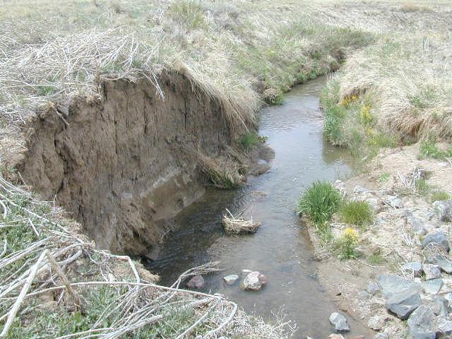
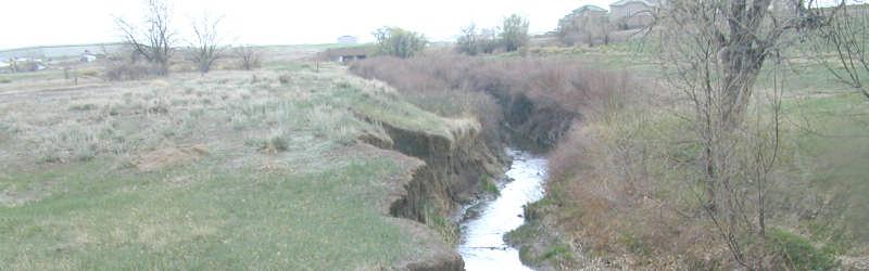
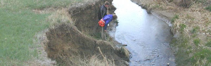
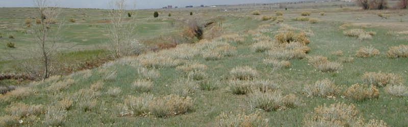
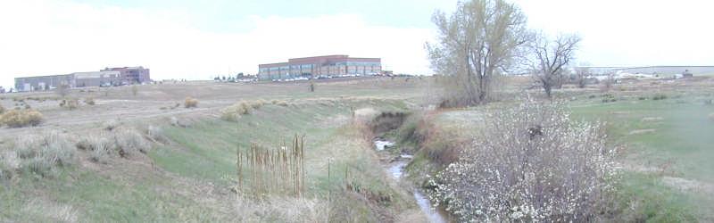
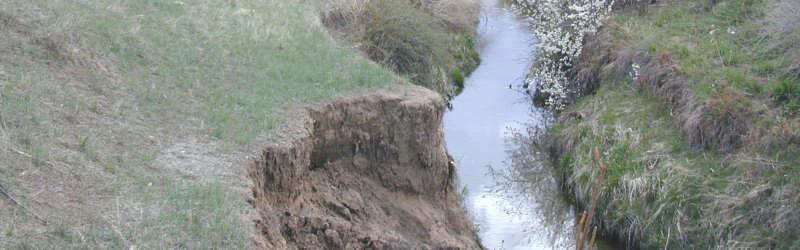
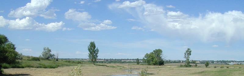
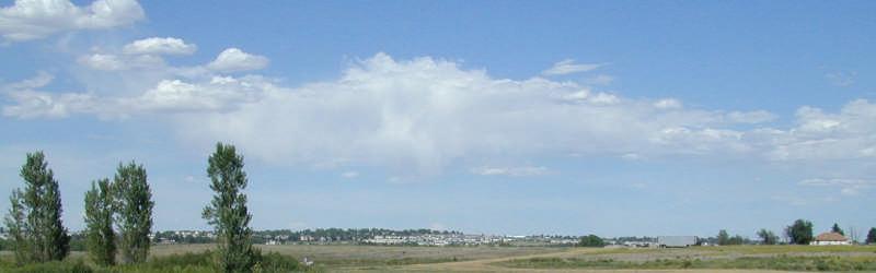
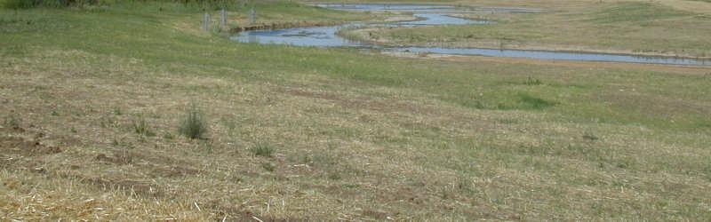
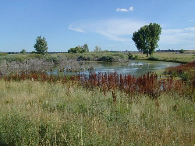
2 COTTONWOOD CREEK RECLAMATION Stream Stabilization Approach to Urban Runoff Quality Cherry Creek Basin Water Quality Authority The Problem The Cherry Creek Reservoir Clean Lakes Study (DRCOG 1984) identified that Reservoir water quality and its uses were moderately impaired and that phosphorus was the limiting nutrient. To protect the water quality of Cherry Creek, the Water quality Control Commission (WQCC) set an in-lake, seasonal chlorophyll a standard of 15- g/l and set a phosphorus goal of 40- g/l (2000, 2001). The Cherry Creek Control Regulation (2004), requires the implementation of best management practices (BMP) for all new development and pollutant reduction facilities throughout the watershed (PRF). PRF are typically larger scale BMP constructed by the Authority that reduce phosphorus loads to the Reservoir. Urbanization of the Cottonwood Creek watershed (8.5 square miles) greatly increased during 1980 s and continues today. Urbanization increases the rate, frequency, duration and magnitude of storm runoff, all of which increases erosion of the streambed and banks. This erosion is evident in the adjacent photo, which shows that the Creek had degraded up to 10-feet within Cherry Creek State Park. These soils, along with other associated pollutants, particularly phosphorus, are being carried into the Reservoir, degrading its quality. Soils were also being carried into the Park from upstream development and ending up in the Reservoir. Flood History Cottonwood Creek through Cherry Creek State Park has a history of flood events that have severely eroded the channel bed and banks and confined it to a narrow section beginning at Peoria Street (see photo above). Flooding has been reported in the past at the intersection of Peoria Street and Belleview Avenue, and within the shooting range, most recently in August Previous farming activities have apparently relocated the lower portion of the channel up on a ridge through the shooting center, rather than in the valley, which has altered the flood plain. Stream Stabilization One Solution The Cottonwood Creek Stream Reclamation project extends from Peoria Street to the Perimeter Road within Cherry Creek State Park. This reach constitutes phase III and IV of the four phase improvements for Lower Cottonwood Creek. Phase I was the perimeter road wetlands constructed in 1996 and Phase II was the Peoria Street extended detention basin, completed in Phase III stream reclamation-peoria Street to the confluence with Lone Tree Creek-was completed in Phase IV-confluence to the Perimeter Road-is scheduled to begin construction in The primary purpose of stream stabilization (Phase III and IV) is to reduce erosion of the streambed and stream banks. Phase III and IV will also enhance growth of wetland and riparian vegetation, will attract wildlife, and will provide passive recreation opportunities, all of which are important objectives in the design approach. The proposed design concept will go beyond simply stabilizing the Creek in place. Improvements will re-create, as closely as possible, a natural, well-vegetated, functional stream system that establishes close ties between its baseflow channel and its broad, flat floodplain overbanks (see picture at left). CotnwdCreekFlyer-v2.doc, 9/16/2005


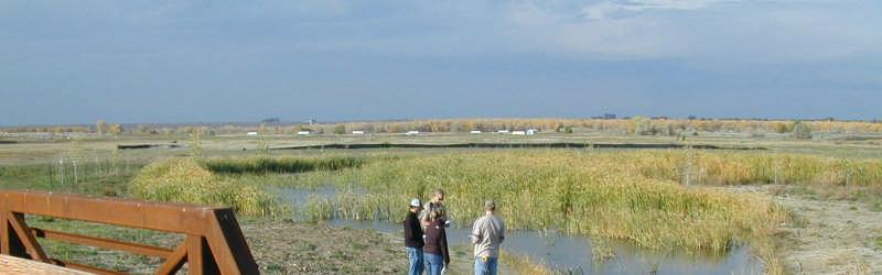
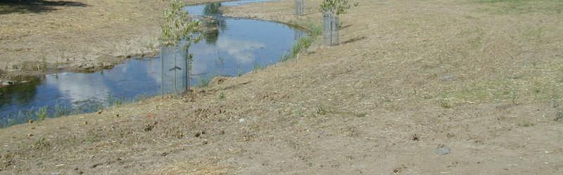
3 Water Quality Benefits Cottonwood Creek will be reclaimed as a meandering, shallow prairie stream that will overtop with fairly frequent storm events, allowing over-banks and secondary channels to dissipate flood flows, thereby reducing velocities and erosive forces. Hydrologic conditions will be conducive to the regeneration of cottonwoods, willows, and other natural riparian species along the channel. This additional vegetation will further help to slow down flood flows, reinforce channel banks, enhance water quality, and provide other environmental benefits. In an attempt to quantify the phosphorus reduction benefits, the Authority has estimated the reduction in phosphorus from stream stabilization and the additional floodplain area and wetlands. 1. Stream Bank Stabilization. The improved stream will increase the length from 11,600 linear feet, with a sinuosity of 1.37 to 14,260 feet, with a sinuosity of Authority estimates for stream stabilization (both banks for Cottonwood Creek only) is approximately 210 pounds of phosphorus per mile for 2.19 miles, per year or around 460 lbs. 2. Flood Plain Area. Existing 2-year floodplain width is 5.3 acres, which will increase to over 80 acres. This will increase the riparian corridor area from 4.4- to 24.9 acres and provide for greater infiltration and filtration by vegetation. Estimates were made of long term phosphorus removal by inundating the floodplain for various flood frequencies, based on dynamic, particle-settling theory. These estimates resulted in a long-term average 1.0 lbs/p per acre/year of floodplain, or around 70 pounds per year. 3. Riparian Wetlands. The existing channel has less than 0.5 acres of riparian wetlands, which are primarily associated with limited channel bottom. The project will widen the channel and increase the frequency of riparian flooding. These improvements are expected to increase riparian wetland areas by 20-acres and immobilize from 200-lbs annually (i.e.: about 10-lbs/ac/yr). 4. Annual Phosphorus Reduction Total of all components is = 730 pounds P. Cottonwood Creek Reclamation Phase 1 was completed in early August 2004 with the first flood occurring on August 18, Based on water-marks at Peoria Street, the peak flow entering the newly constructed channel was estimated to be 1400 cfs, which compares to the projected 100-year event of 4,000cfs. The photo below shows the restored creek during the flood event. The success of the project is attributed to the "low-energy" design. This approach flattens the channel slope decreasing velocity (kinetic energy) and allows the flood to spread over larger areas, increasing flow area and decreasing velocity. Additional Information Information about the Cherry Creek Basin Water Quality Authority can be obtained from our recently created website at CotnwdCreekFlyer-v2.doc, 9/16/2005
4

5
CHERRY CREEK BASIN PHOSPHORUS CONTROL PROJECTS
 CHERRY CREEK BASIN PHOSPHORUS CONTROL PROJECTS Jim Wulliman Muller Engineering Company ABSTRACT A variety of water quality projects have been constructed in the Cherry Creek watershed to control phosphorus
ADDENDUM #1 RFP WOLFTRAP CREEK STREAM RESTORATION
 ADDENDUM #1 February 6, 2015 RFP 15-03 WOLFTRAP CREEK STREAM RESTORATION ******ATTENTION BIDDERS****** (To be completed and returned with bid response) A request was made that the Stormwater Local Assistance
INDIAN CREEK WATERSHED PLAN EXECUTIVE SUMMARY
 INDIAN CREEK WATERSHED PLAN EXECUTIVE SUMMARY The Indian Creek Watershed covers a 38 square mile area in southern Lake County, Illinois that drains 24,116 acres before discharging into the Des Plaines
The Lower Watershed Ecosystem Services in Coastal Areas with a focus on the Courtenay River Floodplain
 The Lower Watershed Ecosystem Services in Coastal Areas with a focus on the Courtenay River Floodplain Jennifer Sutherst Estuary Coordinator and Staff Biologist Comox Valley Project Watershed Society Lower
Memorandum BACKGROUND AND PURPOSE
 COTTONWOOD WETLANDS Memorandum William P. Ruzzo, PE, LLC 6641 West Hamilton Drive, Lakewood, Colorado 80227 (303) 985-1091 (303) 989-6561 fax bill.ruzzo@comcast.net To: Chuck Reid, Manager, CCBWQA Cc:
Jason R. Vogel, Ph.D., P.E. Biosystems and Agricultural Engineering Oklahoma State University
 Stormwater 101 OKLAHOMA STATE UNIVERSITY Biosystems and Agricultural Engineering Department Jason R. Vogel, Ph.D., P.E. Biosystems and Agricultural Engineering Oklahoma State University Stormwater is excess
BMP 5.4.2: Protect /Conserve/Enhance Riparian Areas
 BMP 5.4.2: Protect /Conserve/Enhance Riparian Areas The Executive Council of the Chesapeake Bay Program defines a Riparian Forest Buffer as "an area of trees, usually accompanied by shrubs and other vegetation,
Constructed Wetland Channel T-9
 Description A constructed wetland channel is a conveyance BMP that is built, in part, to enhance stormwater quality. Constructed wetland channels use dense vegetation to slow down runoff and allow time
Oshawa Creek Watershed Management Plan EXECUTIVE SUMMARY
 Oshawa Creek Watershed Management Plan EXECUTIVE SUMMARY The Central Lake Ontario Conservation Authority (CLOCA) has recognized the need to prepare comprehensive management strategies for all of its watersheds.
COON CREEK WATERSHED DISTRICT PERMIT REVIEW Mississippi Dr Coon Rapids, MN SQ FT Residence on 0.64 Acre Lot
 17-082 Van Sloun Residence, Page 1 of 5 COON CREEK WATERSHED DISTRICT PERMIT REVIEW MEETING DATE: May 8, 2017 AGENDA NUMBER: 17 FILE NUMBER: 17-082 ITEM: Van Sloun Residence RECOMMENDATION: Approve with
CDOT-Arapahoe Road over Cherry Creek Water Quality Report
 Cherry Creek Basin Water Quality Authority 8390 East Crescent Parkway, Suite 500 Greenwood Village, Colorado 80111 (P) 303.779.4525 (F) 303.773.2050 January 10, 2013 Ms. Tiffany Clark, PE. SEMSWA 86 Inverness
Drainage Criteria Manual Review
 City of Colorado Springs Stormwater Management Assessment and Standards Development Drainage Criteria Manual Review March 8, 2013 Springsgov.com/City Agencies/Stormwater/Stormwater Engineering/ Stormwater
Bluff Creek One Water
 Bluff Creek One Water The Bluff Creek Watershed has no lakes within its boundaries. As the westernmost watershed within the District, land use changes from agricultural to residential have occurred relatively
Constructed Wetland Pond T-8
 Constructed Wetland Pond T-8 Description A constructed wetlands pond is a shallow retention pond designed to permit the growth of wetland plants such as rushes, willows, and cattails. Constructed wetlands
Stream and Watershed Restoration Design and Quantitative Benefits. Kelly Gutshall, RLA and Mike LaSala
 Stream and Watershed Restoration Design and Quantitative Benefits Kelly Gutshall, RLA and Mike LaSala Suquehanna Greenway River Towns Workshop September 30, 2013 Benefit Stacking Single Function Multiple
Old Mill School Stream Restoration
 Project Overview This conceptual plan restores and stabilizes two consecutive reaches of a highly incised and unstable stream and reconnects them with the floodplain. The restoration reaches are part of
4. Present Activities and Roles
 4. Present Activities and Roles The present missions, authorities, activities and roles of the various agencies involved with flood protection, floodplain management and flood-damage reduction are identified
Cherry Creek State Park - Cherry Creek Stream 12-Mile Park Phase II Cherry Creek Basin Water Quality Authority
 MEMORANDUM JRS ENGINEERING CONSULTANT, LLC TO: Chuck Reid, Manager - CCBWQA CC: Rick Goncalves, PE, TAC Chairman FROM: James R. "Jim" Swanson, PE DATE: October 21, 2014 SUBJECT: Cherry Creek Stream Reclamation
Mill Creek Restoration in Lower Merion Township. PH (610) ; FAX (610) ;
 ; FAX (610) ;") Mill Creek Restoration in Lower Merion Township Vincent L. Sortman 1 and Robert M. Lambert 2 1 Biohabitats, Inc., 15 W. Aylesbury Road, Timonium, MD 21093; PH (410) 337-3659; FAX (410) 583-5678; email:
Mill Creek Restoration in Lower Merion Township Vincent L. Sortman 1 and Robert M. Lambert 2 1 Biohabitats, Inc., 15 W. Aylesbury Road, Timonium, MD 21093; PH (410) 337-3659; FAX (410) 583-5678; email:
5.15 Wetlands and Other Waters of the U.S.
 I-70 East Final EIS 5.15 Wetlands and Other Waters of the U.S. 5.15 Wetlands and Other Waters of the U.S. This section discusses wetlands, open waters, and other waters of the U.S. in the study area and
Section 6: Stormwater Improvements
 Section 6: Stormwater Improvements A major objective of this study was to identify opportunities for improvements to address the widespread water quality impairments caused by stormwater runoff in the
EXECUTIVE SUMMARY DES PLAINES RIVER WATERSHED-BASED PLAN WHY A WATERSHED-BASED PLAN? WHAT IS A WATERSHED?
 Des Plaines River Watershed-Based Plan EXECUTIVE SUMMARY June 2018 EXECUTIVE SUMMARY DES PLAINES RIVER WATERSHED-BASED PLAN WHY A WATERSHED-BASED PLAN? Water is elemental to our lives. Plants and animals,
4. Ponds and infiltration BMPs can achieve 60 to 100% removal efficiencies for sediment.
 Landscape BMPs For the purposes of this project, preventive measures have been categorized into two categories: landscape BMPs and source prevention BMPs. Landscape BMPs includes both vegetative practices
MONTEREY PENINSULA WATER MANAGEMENT DISTRICT PROJECT DESCRIPTION FOR SELECTIVE VEGETATION MANAGEMENT AND BANK RESTORATION (RANCHO SAN CARLOS AREA)
") MONTEREY PENINSULA WATER MANAGEMENT DISTRICT PROJECT DESCRIPTION FOR SELECTIVE VEGETATION MANAGEMENT AND BANK RESTORATION (RANCHO SAN CARLOS AREA) IN THE CARMEL RIVER CHANNEL, SUMMER AND FALL 2014 SELECTIVE
MONTEREY PENINSULA WATER MANAGEMENT DISTRICT PROJECT DESCRIPTION FOR SELECTIVE VEGETATION MANAGEMENT AND BANK RESTORATION (RANCHO SAN CARLOS AREA) IN THE CARMEL RIVER CHANNEL, SUMMER AND FALL 2014 SELECTIVE
Hydrology 101. Impacts of the Urban Environment. Nokomis Knolls Pond Summer June 2008
 Hydrology 101 Nokomis Knolls Pond Summer 2002 Impacts of the Urban Environment Hydrologic Cycle; What is it? Geography, Topography, Geology, Land Cover and Climate determine the Amount and Behavior of
COON CREEK WATERSHED DISTRICT PERMIT REVIEW. Spring Lake Park Schools Westwood Middle School st Avenue NE, Spring Lake Park, MN 55432
 PAN 16-112, Westwood Middle School, Page 1 of 6 COON CREEK WATERSHED DISTRICT PERMIT REVIEW MEETING DATE: August 22, 2016 AGENDA NUMBER: 10 FILE NUMBER: 16-112 ITEM: Westwood Middle School RECOMMENDATION:
Rainfall, runoff and sediment transport in the Napa River watershed: now and a possible future
 Rainfall, runoff and sediment transport in the Napa River watershed: now and a possible future Lester McKee San Francisco Estuary Institute 5/24/2017 1 The importance of the natural water cycle of infiltration
Maintaining Riparian Areas and Wetlands
 Maintaining Riparian Areas and Wetlands Riparian areas are the lands along the banks of our rivers, lakes, and tidal waters. Many riparian areas not only border surface waters, but they are often adjacent
Understanding and Restoring Natural Floodplain Function. Gary James CTUIR Fisheries Program Manager
 Understanding and Restoring Natural Floodplain Function Gary James Fisheries Program Manager Future of Our Salmon Technical Workshop on Healthy Floodplains Spokane, WA - August 16-18, 2016 Presentation
ANCR INDIVIDUAL RESPONSES SUMMARY: 2/11/04 WATER RESOURCES GOALS AND OBJECTIVES
 ANCR INDIVIDUAL RESPONSES SUMMARY: 2/11/04 WATER RESOURCES GOALS AND OBJECTIVES Goal 1: Protect the health and safety of the Dane County population. a. Prevent development that may have an adverse effect
Watershed Hydrology: Go with the flow. Greg Jennings, PhD, PE
 Watershed Hydrology: Go with the flow Greg Jennings, PhD, PE jenningsenv@gmail.com Streams What are your CHALLENGES? Hydrology too much water Pollutants upstream and on-site Vegetation wrong plants, wrong
California Rapid Assessment Method for Wetlands (CRAM) Buffer and Landscape Context Attribute
 Buffer and Landscape Context Attribute") California Rapid Assessment Method for Wetlands (CRAM) Buffer and Landscape Context Attribute Buffer and Landscape Context Attribute Presence and/or continuity of wetlands and riparian areas adjacent to
California Rapid Assessment Method for Wetlands (CRAM) Buffer and Landscape Context Attribute Buffer and Landscape Context Attribute Presence and/or continuity of wetlands and riparian areas adjacent to
1/16/2016. California Rapid Assessment Method for Wetlands (CRAM) Buffer and Landscape Context Attribute. Buffer and Landscape Context Attribute
 Buffer and Landscape Context Attribute. Buffer and Landscape Context Attribute") California Rapid Assessment Method for Wetlands (CRAM) Buffer and Landscape Context Attribute Buffer and Landscape Context Attribute Presence and/or continuity of wetlands and riparian areas adjacent to
California Rapid Assessment Method for Wetlands (CRAM) Buffer and Landscape Context Attribute Buffer and Landscape Context Attribute Presence and/or continuity of wetlands and riparian areas adjacent to
IAFSM 2010 Annual Conference. City of Rockford Keith Creek Greenway Flood Mitigation Project
 IAFSM 2010 Annual Conference City of Rockford Keith Creek Greenway Flood Mitigation Project March 10, 2010 Introduction Problem Overview 1890 s Building of homes along Keith Creek 1920 s Home construction
SECTION IV WATERSHED TECHNICAL ANALYSIS
 A. Watershed Modeling SECTION IV WATERSHED TECHNICAL ANALYSIS An initial step in the preparation of this stormwater management plan was the selection of a stormwater simulation model to be utilized. It
Riparian Buffer Requirements. Department of Environmental Protection Bureau of Watershed Management
 102.14 - Riparian Buffer Requirements Department of Environmental Protection Bureau of Watershed Management 102.2 Scope and Purpose BMPs to protect, maintain, and restore water quality and existing designated
Wood Canyon Emergent Wetland Project. City of Aliso Viejo 12 Journey, Suite 100 Aliso Viejo, CA 92656
 Wood Canyon Emergent Wetland Project City of Aliso Viejo 12 Journey, Suite 100 Aliso Viejo, CA 92656 Introduction Wood Canyon is located within Aliso and Wood Canyon Regional Park in southwest Orange County,
Lake Creek Watershed Management Plan Public Meeting. Arrowhead Lake May 3, :00 PM
 Lake Creek Watershed Management Plan Public Meeting Arrowhead Lake May 3, 2018 6:00 PM Agenda I. Welcome and Introductions II. III. IV. Watershed Basics Overview of Lake Creek Watershed Elements of a Successful
Site Condition Evaluation & Environmental Benefits Report
 Site Evaluation & Environmental Benefits Report Background The New York State Conservation Reserve Enhancement Program is a collaborative effort between the USDA and the State of New York. The goal of
Installation of the geocell retaining walls is under way a few feet from the normal creek level.
 Installation of the geocell retaining walls is under way a few feet from the normal creek level. 18 Geosynthetics April May 2017 Flood impact reduction and streambank repair along Spy Run Creek By Anne
LAKE COUNTY HYDROLOGY DESIGN STANDARDS
 LAKE COUNTY HYDROLOGY DESIGN STANDARDS Lake County Department of Public Works Water Resources Division 255 N. Forbes Street Lakeport, CA 95453 (707)263-2341 Adopted June 22, 1999 These Standards provide
STREAM RESTORATION PURPOSE, PRACTICE, AND METHODS. By Marcus Rubenstein, CPESC
 STREAM RESTORATION PURPOSE, PRACTICE, AND METHODS By Marcus Rubenstein, CPESC WHAT IS STREAM RESTORATION? The return of a stream s lost natural functions, usually resulting from watershed alterations,
Stream Buffers Sharpest Tool in the SWM Toolbox Tom Hegemier, PE, D.WRE, CFM
 Stream Buffers Sharpest Tool in the SWM Toolbox 1 Tom Hegemier, PE, D.WRE, CFM www.apaienv.com Stream Buffers - Overview 2 Why stream buffers? Floodplain management and other benefits Existing regulatory
CHAPTER 1. Ecological Integrity
 CHAPTER 1 Ecological Integrity RIPARIAN RESTORATION ECOLOGICAL INTEGRITY This chapter suggests a broad interpretation of the riparian ecosystem and its influences. Often riparian ecosystems are described
Appendix B Stormwater Site Plan Submittal Requirements Checklist
 Stormwater Site Plan Submittal Requirements Checklist The Submittal Requirements Checklist is intended to aid the design engineer in preparing a Stormwater Site Plan. All items included in the following
Design, Construction, & Benefits of Integrated Stream & Wetland Stormwater Restoration Projects Presented By: Underwood & Associates / Biohabitats,
 Design, Construction, & Benefits of Integrated Stream & Wetland Stormwater Restoration Projects Presented By: Underwood & Associates / Biohabitats, Inc. RELATIONSHIP BETWEEN IMPERVIOUS COVER AND SURFACE
CITY OF AUSTIN'S REGULATORY FRAMEWORK FOR CREEK PROTECTION
 CITY OF AUSTIN'S REGULATORY FRAMEWORK FOR CREEK PROTECTION Liz Johnston, Watershed Protection Department Urban Riparian Symposium February 15 17, 2017 Houston, TX Valuable Resource Drinking Water Intake
STREAM AND BUFFER AREA PROTECTION/RESTORATION
 STREAM AND BUFFER AREA PROTECTION/RESTORATION AMENDMENT OPTIONS TO STRENGTHEN POLICY IN HEADWATERS AREAS DRAFT SUBSEQUENT TO THE JANUARY 25, 2007 MEETING OF THE PLANNING COMMISSION ENVIRONMENT COMMITTEE
PROJECT SCREENING MATRIX: A User s Guide
 Version 2.0 Page 1 of 7 November 9, 2010 PROJECT SCREENING MATRIX: A User s Guide BACKGROUND The Project Screening Matrix (Screening Matrix) is one of several tools that comprise the River Restoration
COON CREEK WATERSHED DISTRICT PERMIT REVIEW
 16-054 Woodland Creek Wetland Banking Restoration Project, Page 1 of 6 COON CREEK WATERSHED DISTRICT PERMIT REVIEW MEETING DATE: August 22, 2016 AGENDA NUMBER: 11 FILE NUMBER: 16-054 ITEM: Woodland Creek
How Climate Change Impacts Urban Runoff and Water Quality Design
 How Climate Change Impacts Urban Runoff and Water Quality Design by J. C. Hayes, C. Privette, III and S. J. Klaine AWRA Conference Anchorage, AK May 4-7, 2009 Presentation Outline Introduction: Why manage
Stormwater Management Tools: Real-Life Solutions for a Resilient Community Riparian Corridor Protection
 Stormwater Management Tools: Real-Life Solutions for a Resilient Community Riparian Corridor Protection Montgomery County Planning Commission October 24, 2013 Eric Jarrell, Assistant Section Chief, Community
Deep River-Portage Burns Waterway Watershed 2015
 2.4 Soils Soil development is the product of the interaction of parent material, topography, climate, organisms and time. Understanding the types of soils that exist within a watershed and their characteristics
Protecting and Enhancing Ecosystem Services the Role of Wetlands and Watershed Management in Flood Attenuation Dr. Mark Gloutney Director Regional
 Protecting and Enhancing Ecosystem Services the Role of Wetlands and Watershed Management in Flood Attenuation Dr. Mark Gloutney Director Regional Operations Eastern Canada April 14 2016 Changes in Storm
Watershed Improvements
 Watershed Improvements Gwinnett County Georgia Association of Floodplain Managers March 14, 2013 Overview Watershed Assessment - 1998 to 2000 Watershed Protection Plan - 2000 Watershed Improvement Plans
3 Baseline and Existing Conditions
 1 2 3 4 5 6 7 8 9 10 11 12 13 14 3 Baseline and Existing Conditions The effective date of the VSP legislation is July 22, 2011. This is also the date chosen by the legislature as the applicable baseline
Vegetative Buffer Regulations to Protect Water quality
 Vegetative Buffer Regulations to Protect Water quality Robert Jontos, PWS, CPESC Land-Tech Consultants, Inc. Environmental Scientists and Engineers Connecticut Association of Conservation and Inland Wetland
Background. AEM Tier 2 Worksheet Stream & Floodplain Management. Glossary
 AEM Tier 2 Worksheet Stream & Floodplain Management Glossary Bankfull Stage: The stage at which water starts to flow over the flood plain; the elevation of the water surface at bankfull discharge. (This
Case Study 19. Mill Creek Embedded Box Culvert Vented Ford
 Case Study. Mill Creek Embedded Box Culvert Vented Ford Location Southeast Missouri. Mark Twain National Forest; Houston-Rolla Ranger District. Southeast of Rolla, south of Interstate 44, off of State
STAFF REPORT FOR POLICY PLAN AMENDMENT S10-CW-1CP
 STAFF REPORT FOR POLICY PLAN AMENDMENT S10-CW-1CP EXECUTIVE SUMMARY This Plan Amendment would serve to clarify policy guidance regarding circumstances under which proposals for disturbances to Environmental
The Table of Contents
 The Tale of a Million Ditches and the 800-Pound Rodent: The surprising truth about hydrology, water quality, and habitat in the headwaters of the Great Coharie WRRI 2014 Annual Conference March 20 th,
Reservoir age, increasing human population,
 B-6249 02/12 Eagle Mountain Watershed Management Brent Clayton, Justin Mechell, David Waidler and Clint Wolfe* Reservoir age, increasing human population, and changing land uses have prompted the development
Post-Development Stormwater Runoff Performance Standards
 Post-Development Stormwater Runoff Performance Standards December 9, 2014 Topics Why performance standards? What practices/requirements are in effect in other States? The Workgroup s preliminary and final
Primer introduction to watershed management Plan Process highlight the major steps of plan development Project types look at some examples of common
 1 Primer introduction to watershed management Plan Process highlight the major steps of plan development Project types look at some examples of common projects Plan Organization how to read the plan Next
14(h)EPA-06 City of Springfield 76 East High Street Springfield, Ohio Clark County Greening City Plaza
EPA-06 City of Springfield 76 East High Street Springfield, Ohio Clark County Greening City Plaza") 14(h)EPA-06 City of Springfield 76 East High Street Springfield, Ohio 45502 Clark County Greening City Plaza $100,000 in FY 2014 Section 319(h) Nonpoint Source grant funding is requested to install three
14(h)EPA-06 City of Springfield 76 East High Street Springfield, Ohio 45502 Clark County Greening City Plaza $100,000 in FY 2014 Section 319(h) Nonpoint Source grant funding is requested to install three
2.4 Floodplain Restoration Principles
 Floodplain Restoration Principles 2.4 Floodplain Restoration Principles Anthropogenic alternation of river corridors and floodplains significantly modified the structure and function of landscapes and
I. Welcome & Introductions WPAC History (Paul Racette, PEC)
") Poquessing Creek Watershed ACT 167 STORM WATER MANAGEMENT PLAN Public Hearing July 10, 2012 I. Welcome & Introductions ---------- WPAC History (Paul Racette, PEC) Primary WPAC Members: Bucks County: Bensalem
Poquessing Creek Watershed ACT 167 STORM WATER MANAGEMENT PLAN Public Hearing July 10, 2012 I. Welcome & Introductions ---------- WPAC History (Paul Racette, PEC) Primary WPAC Members: Bucks County: Bensalem
Restoration of Riparian Forests and Riparian Ecosystem Processes and Implications for Salmon Restoration. Katie Ross-Smith Jennifer Hammond
 Restoration of Riparian Forests and Riparian Ecosystem Processes and Implications for Salmon Restoration Katie Ross-Smith Jennifer Hammond Outline > Background California riparian communities Riparian
Project Priority List scoring worksheet - stormwater Guidance document
 www.pca.state.mn.us Project Priority List scoring worksheet - stormwater Guidance document PLEASE NOTE: THE MINNESOTA STATE FISCAL YEAR IS FROM JULY 1 JUNE 30 The first step towards receiving either a
Municipal Stormwater Management Plan Prepared For The Borough of Cape May Point By Van Note-Harvey Associates VNH File No.
 Municipal Stormwater Management Plan Prepared For The Borough of Cape May Point By Van Note-Harvey Associates 2005 VNH File No. 35317-210-21 Table of Contents Introduction... 3 Goals... 3 Storm water Discussion...
RIVERSIDE OXBOW FORT WORTH, TEXAS CHAPTER 3 IDENTIFICATION OF PROBLEMS AND OPPORTUNITIES
 RIVERSIDE OXBOW FORT WORTH, TEXAS CHAPTER 3 IDENTIFICATION OF PROBLEMS AND OPPORTUNITIES Regular study team meetings were held with the Tarrant Regional Water District, the USFWS, Streams and Valleys,
RIPARIAN CORRIDOR STUDY FINAL PARLEYS CREEK MANAGEMENT PLAN TABLE OF CONTENTS
 TABLE OF CONTENTS 1.0 INTRODUCTION... 1-1 Riparian Corridor Study and Management Plan Goals... 1-1 Study Area... 1-2 Importance and Functions of Riparian Corridors... 1-2 Habitat for Mammals, Birds, and
Implementing Restoration Projects Upstream from the Teaneck Creek Conservancy
 from the Teaneck Creek Conservancy by Jeremiah D. Bergstrom 1, Peter Kallin 2, and Christopher Obropta 3 1 Water Resources, TRC Environmental Corporation, Trenton, New Jersey 08628 2 Belgrade Regional
Appendix E : Guidelines for Riparian Buffer Areas
 Appendix E : Guidelines for Riparian Buffer Areas This document should be read in conjunction with the CRCA Planning Policy. 1.0 PURPOSE The purpose of this document is to summarize the recommendations
Chapter 3 Dispersion BMPs
 Chapter 3 Dispersion BMPs 3.1 BMP L611 Concentrated Flow Dispersion 3.1.1 Purpose and Definition Dispersion of concentrated flows from driveways or other pavement through a vegetated pervious area attenuates
A resource assessment of the Etowah Watershed
 A resource assessment of the Etowah Watershed The Upper Etowah watershed drains a region dominated by rolling Piedmont topography with interspersed forest cover, agricultural and urban land uses. With
STORM DRAINAGE DESIGN MANUAL
 Appendix I STORM DRAINAGE DESIGN MANUAL by: SUNGATE DESIGN GROUP, P.A. GEN ERAL DESIGN STAN DARDS AN D POLICIES 1. STREET AND LOCAL DRAINAGE Discharge estimates for specified design storms shall be calculated
Harris County Flood Control District Site Stabilization and Revegetation
 Harris County Flood Control District Site Stabilization and Revegetation Carolyn White, CPESC Stormwater Quality Department Clean Waters Initiative Wednesday, March 23, 2011 Presentation Outline HCFCD
FIGURE 12-1 FUNCTIONS AND BENEFITS OF HEALTHY STREAMS
 12.0 Introduction This chapter summarizes the analysis and design methodology for drainageway improvements within the County. Definitions are provided for minor and major drainageways and design considerations
Municipal Stormwater Management Planning
 Municipal Stormwater Management Planning Christopher C. Obropta, Ph.D., P.E. Water Resources Extension Specialist with Rutgers Cooperative Extension Assistant Professor with Department of Environmental
719 Griswold, Suite 820 Detroit, MI DANVERS POND DAM REMOVAL AND STREAM RESTORATION PROJECT
 Great Lakes Restoration Initiative Grant Final Report US EPA Grant GL 00E006 43 October, 2013 Valley Woods Wetland Southfield Lola Valley Grow Zone Wayne County Parks Venoy Park Grow Zone Wayne County
Clean Water Services Design and Construction Standards Update: Base Strategy and Methodology to Address Hydromodification Impacts
 Clean Water Services Design and Construction Standards Update: Base Strategy and Methodology to Address Hydromodification Impacts 1.0 INTRODUCTION The proposed hydromodification base strategy (Base Strategy)
Incorporating Restoration Planning and Transportation Controls into the Valley Creek Watershed Act 167 Stormwater Management Plan
 Incorporating Restoration Planning and Transportation Controls into the Valley Creek Watershed Act 167 Stormwater Management Plan Pennsylvania State Section American Water Resources Association Fall 2011
Water Quality Technical Memorandum
 Southeast Extension Project Lincoln Station to RidgeGate Parkway Prepared for: Federal Transit Administration Prepared by: Denver Regional Transportation District May 2014 Table of Contents Page No. Chapter
Glossary of Terms. Aquifer A permeable body of rock capable of yielding quantities of groundwater to wells and springs.
 Glossary of Terms 100-year flood A large, but infrequent, flood event that has a 1% chance of occurring in any given year (occurs, on average, once every 100 years). 100-year floodplain Areas adjacent
Impact of Increased Stormwater Runoff on Urban Drainage Systems
 Impact of Increased Stormwater William E. Spearman, III, PE APWA Stormwater Summit San Antonio, TX September 12, 2007 Contact Information: William E. Spearman, III, PE Member, APWA National Water Resources
11. Public Utilities. Key Terminology: OVERVIEW STORMWATER MANAGEMENT WATERSHED MANAGEMENT ORGANIZATIONS AND COMMISSIONS. Inventory and Analysis
 Inventory and Analysis 11. Public Utilities Urbanized (drainage): Defined as an area where natural soils, waterways, and environmental functions are replaced with impervious surfaces (roads, parking lots,
BUREAU OF CLEAN WATER
 COMMONWEALTH OF PENNSYLVANIA DEPARTMENT OF ENVIRONMENTAL PROTECTION BUREAU OF CLEAN WATER NATIONAL POLLUTANT DISCHARGE ELIMINATION SYSTEM (NPDES) STORMWATER DISCHARGES FROM SMALL MUNICIPAL SEPARATE STORM
SHORELINE INVENTORY AND RESTORATION PLANNING
 CHAPTER 3 SHORELINE INVENTORY AND RESTORATION PLANNING A. PURPOSE OF THE SHORELINE INVENTORY AND CHARACTERIZATION A first step in the comprehensive Master Program update process is development of a shoreline
HYDROLOGIC CONSIDERATIONS. 22 nd Annual Nonpoint Source Pollution Conference Saratoga Springs, NY
 LOW IMPACT DEVELOPMENT HYDROLOGIC CONSIDERATIONS 22 nd Annual Nonpoint Source Pollution Conference Saratoga Springs, NY May 18, 2011 PRESENTATION AGENDA Introduction Definitions Discuss Impacts to Hydrologic
Pennsylvania Stormwater Best Management Practices Manual. Chapter 3. Stormwater Management Principles and Recommended Control Guidelines
 Pennsylvania Stormwater Best Management Practices Manual Chapter 3 Stormwater Management Principles and Recommended Control Guidelines 363-0300-002 / December 30, 2006 Chapter 3 Stormwater Management Principles
Griswold Creek Subwatershed
 Griswold Creek Subwatershed Griswold Creek is located in Chester and Russell Townships and flows into the Chagrin River in the Village of Hunting Valley. Since the forming of the Chagrin River Watershed
Water Quality Ecosystem Services in the Urban Environment
 Water Quality Ecosystem Services in the Urban Environment Dianna Hogan and JV Loperfido ACES 2010 December 7, 2010 U.S. Department of the Interior U.S. Geological Survey Water Quality Ecosystem Services
TABLE OF CONTENTS. TOC-i
 TOC-i TABLE OF CONTENTS 1.0 INTRODUCTION... 1-1 Riparian Corridor Study and Management Plan Goals... 1-1 Study Area... 1-2 Importance and Functions of Riparian Corridors... 1-2 Habitat for Mammals, Birds,
Southeast Policy Area Drainage Study
 Southeast Policy Area Drainage Study Prepared for City of Elk Grove January 2014 448-00-12-03 Table of Contents 1.0 Introduction... 1 2.0 Watershed Description... 1 3.0 Drainage Plan Concept... 1 4.0
RIPARIAN AREAS REGULATION
 Definitions and interpretation RIPARIAN AREAS REGULATION 1 (1) In this regulation: Act means the Fish Protection Act; active floodplain means an area of land that supports floodplain plant species and
Presentation Overview
 Little Dry Creek Restoration Deep River Flood Risk Management Final Presentation to LCRBDC June 10, 2015 Presentation Overview Project Overview & Background Information Data Collection Model Development
Wetland Resources Cultural, Historical and Environmental Significance
 Wetland Resources Cultural, Historical and Environmental Significance Maryann McGraw Wetlands Program Coordinator New Mexico Environment Department Wetlands Program What is a wetland? (What is a mountain?
S.R. 4007, Section 14B PADEP Environmental Assessment Form. Enclosure C Description of Aquatic Habitat
 S.R. 4007, Section 14B PADEP Environmental Assessment Form Description of Aquatic Habitat Cresheim Creek is the only water resource that exists within the project area. No jurisdictional wetlands were