2040 LAND USE WORKBOOK February 2017
|
|
|
- Sharleen Garrison
- 5 years ago
- Views:
Transcription


1 040 LAND USE WORKBOOK February 017


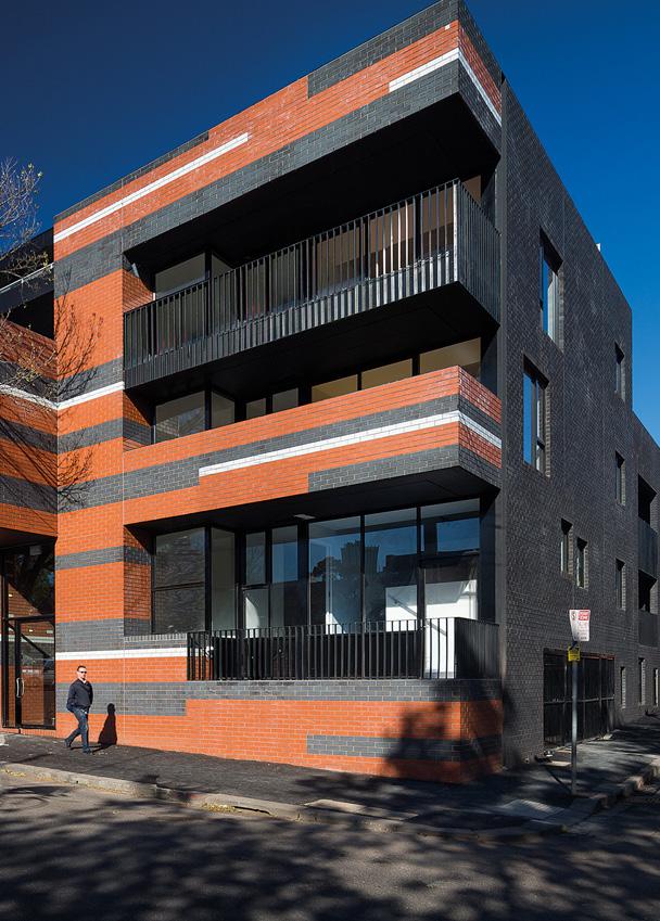
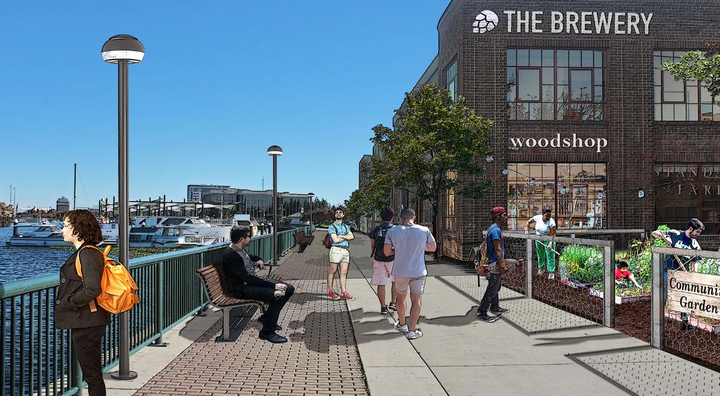
2 S A/C INTRODUCTION SITE SPOTLIGHT: WATERFRONT Through a series of community workshops and online activities in 016, Stockton community members shared their vision for the future of the city and for key study areas where positive change is highly desired. The broad range of ideas generated through that process was distilled into three The waterfront site is located on the south shore of distinct future scenarios, each of which describes a different way that Stockton the channel, just east of I-5. The site is connected via a could evolve over the next 5 years. This workbook introduces the three future promenade to other Downtown destinations, including scenarios (see pages 6-7 for a summary of each) and compares them to help the the Marina, Weber Point Events Center, Waterfront Stockton community decide which scenario, or combination of components from Hotel, Arena, and Ballpark. Maintaining connections the scenarios, offers the most benefit. That preferred scenario determined with your input will serve as the backbone of the updated General Plan. VISUAL SIMULATIONS 1 and orientation to the promenade and waterfront is an WATERFRONT 833 W WEBER AVE DOWNTOWN 100 E WEBER AVE The following pages spotlight three different locations in Stockton, visually depicting what the three different future development scenarios could mean at a particular site. For each location, there is a photo showing how the site looks today, followed by simulations of possible future development based on the land use designation for the site under each general plan alternative. important feature of future development. Alternatives A and C both designate this site Commercial, so the top photo on the right applies to both alternatives. SCENARIO LAND USE DESIGNATION DEVELOPMENT TYPE S A AND C COMMERCIAL MIXED USE RETAIL, RESTAURANTS, AND HOUSING B INDUSTRIAL BREWERY, LIGHT INDUSTRIAL, AND COMMUNITY GARDEN B The three sites that are spotlighted in this section are all vacant, and the simulations are meant to be illustrative of what the scenarios could mean for these or other EXISTING similar sites. These locations are shown to the right, and exemplify sites in need of investment to fuel positive change along the waterfront, in the eastern part of Downtown, and in South Stockton. 3 SOUTH STOCKTON 348 S AIRPORT WAY 3


3 A A/C SITE SPOTLIGHT: DOWNTOWN SITE SPOTLIGHT: SOUTH STOCKTON The Downtown site is located across Weber Avenue and The South Stockton site is located along South Airport the railroad tracks from the ACE train station, offering Way at 10th Street, across from the new credit union convenient transit access throughout the region to building. There are large stretches of vacant land along potential future site occupants. Effective pedestrian this corridor, and investment here could bring needed and bicycle access and safety will be key to any future services to the South Stockton area, like grocery stores development in order to maximize potential benefits and medical facilities, while infusing the surrounding from transit proximity. Alternatives B and C both neighborhoods with positive change. Alternatives A and designate this site Commercial, so the bottom photo on C both designate this site Commercial, so the top photo the right applies to both alternatives. on the right applies to both alternatives. SCENARIO LAND USE DESIGNATION DEVELOPMENT TYPE A INDUSTRIAL S B AND C COMMERCIAL EXISTING 4 SCENARIO LAND USE DESIGNATION DEVELOPMENT TYPE LIGHT MANUFACTURING S A AND C COMMERCIAL SMALL GROCERY STORE MIXED USE OFFICE, RESTAURANT, AND HOUSING B ADMINISTRATIVE PROFESSIONAL MEDICAL OFFICES B/C B EXISTING 5

4 SUMMARY OF S The three alternatives are shown to the right. Each of these future scenarios includes a different pattern of land uses, which in turn has a different capacity for new development; generally, the existing General Plan allows the most new development and the Infill Focus Scenario allows the least. In addition to the alternative land use patterns shown on the maps, this workbook also considers alternative growth scenarios. VILLAGE OPEN SPACE OTHER CITY LIMIT VILLAGE OPEN SPACE VILLAGE & OPEN SPACE AREAS AT THE CITY PERIPHERY The numbers shown in the table below are based on economic assumptions OTHER CITY LIMIT OPEN SPACE OTHER VILLAGE & OPEN SPACE AREAS AT THE CITY PERIPHERY CITY LIMIT VILLAGE & OPEN SPACE AREAS AT THE CITY PERIPHERY about the projected market demands for various land uses by 040. They account for new development within the study areas and for approved projects like major new subdivisions. Each scenario includes a certain amount of new and approved development by 040 based on those market assumptions. COMPARISON OF GROWTH SCENARIOS HIGH % CHANGE 040 VS 016 MEDIUM % CHANGE 040 VS 016 LOW % CHANGE 040 VS ,850 40% 90,150 9% 58,490 19% JOBS 44,310 55% 4,780 53% 41,30 51% HOUSING UNITS 41,000 41% 30,330 30% 19,690 0% POPULATION SINGLE-FAMILY MULTI-FAMILY 6 8,700 1,300 44% 35% 1,30 9,100 33% 6% 13,780 5,910 1% 17% A: EXISTING GENERAL PLAN This scenario follows the land use designations identified in the current General Plan, which calls for most residential growth to occur in villages at the edges of the city that would include a range of housing choices and neighborhood amenities in new communities, including in some locations beyond the current Sphere of Influence (the area identified by the City and regional planning agencies for possible future expansion). Nonresidential growth is planned at regional and neighborhood commercial centers, new office uses along I-5 and in the Downtown, and new industrial uses in South Stockton. B: CORRIDORS FOCUS This scenario is similar to the existing General Plan but emphasizes retail and mixed-use development along major corridors. At the edges of the city, this scenario maintains the village concept from the current General Plan but limits urban development to the current Sphere of Influence. This scenario also incorporates other changes to reflect existing zoning and/or existing uses, such as the industrial zoning at the port and well-established existing public, commercial, and industrial uses along the N West Lane corridor. C: INFILL FOCUS This scenario emphasizes relatively dense infill development near the city s Downtown core, as well as in the southern and eastern portions of the city, including multi-family residential and mixed-use development (which combines housing with office and/or retail). At the edges of the city, this scenario would eliminate the village concept from the current General Plan, shrink the current Sphere of Influence, and reserve much of the area beyond the city limit for open space and agriculture uses. 7


 CITY CORE:")

5 COMMUNITY CHARACTER The study areas considered in each scenario include key corridors and areas with high concentrations of vacant and underutilized land where investment could catalyze positive change. Outside these core locations in the city, the study areas also include neighborhoods planned for new village -style development under the existing General Plan. In this Community Character section, please consider how the look and feel of the study areas could change under each scenario, and how that could affect the rest of Stockton. A: EXISTING GENERAL PLAN B: CORRIDORS FOCUS C: INFILL FOCUS The current General Plan focuses investment and new development in village - This future development scenario enhances existing commercial corridors This scenario focuses new development within the city core, leaving land in type communities located at the peripheries of the city. These villages are with new retail development and housing above retail along key streets to the periphery as undeveloped open space and agriculture. Similar to the intended to be self-sustaining, with a mix of housing types and densities served create vibrant shopping centers within the city core. Commercial corridors Corridors Focus Scenario, existing commercial corridors would be enhanced by a village center that includes retail, schools, parks, and public services. A mix would be a mix of areas lined with smaller-scale store fronts and intermittent and more continuous. Vital commercial corridors would include a focus on of commercial and industrial uses would continue to be allowed along major larger shopping centers. New development is less focused on the periphery of infill development with new higher-density residential buildings and mixed-use arterials in the city core. the city to preserve open space land and to promote more infill development shopping centers, providing current and new residents with convenient access within the city core. to retail and services. KEY ASPECTS THAT AFFECT THE CHARACTER OF THE CITY INCLUDE: KEY ASPECTS THAT AFFECT THE CHARACTER OF THE CITY INCLUDE: KEY ASPECTS THAT AFFECT THE CHARACTER OF THE CITY INCLUDE: LARGEST GEOGRAPHIC REACH OF DEVELOPMENT CITY CORE: GENERALLY MAINTAINS EXISTING CHARACTER What type of development do you want to see along key corridors? How far geographically should the city s development extend? LESS INTENSIVE, AUTOMOBILE-ORIENTED COMMERCIAL AND INDUSTRIAL USES ALONG KEY CORRIDORS OPPORTUNITIES FOR WATERFRONT AND DOWNTOWN MIXEDUSE DEVELOPMENT CITY PERIPHERY: CHANGE SOME AGRICULTURE/ OPEN SPACE AREAS TO URBAN USES NEW VILLAGE DEVELOPMENTS LESS CONNECTED TO CITY CORE AND MAJOR ARTERIALS DEVELOPMENT EXTENT THAT ALIGNS WITH THE CITY S CURRENT SPHERE OF INFLUENCE (SOI) CITY CORE: MAINTAINS THE EXISTING CHARACTER IN MANY AREAS INTENSIFIES USE OF COMMERCIAL CORRIDORS AND SHIFTS INDUSTRIAL USES TO OUTLYING LOCATIONS PROMOTES PEDESTRIAN AND BICYCLE CONNECTIVITY AND ACCESS ALONG CONTINUOUS/LINKED COMMERCIAL CORRIDORS OPPORTUNITIES FOR PROFESSIONAL AND MEDICAL OFFICES NEAR WESTON RANCH EXPANDED OPPORTUNITIES FOR LARGE GROCERY STORES ALONG SOUTH AIRPORT WAY IN SOUTH STOCKTON SMALLEST GEOGRAPHIC REACH OF DEVELOPMENT CITY CORE: MOST SIGNIFICANT AREA OF CHANGE FROM EXISTING CHARACTER SUBSTANTIAL HIGHER INTENSITY MIXED-USE DEVELOPMENT TO CREATE A WALKABLE ENVIRONMENT MORE OPPORTUNITIES FOR HIGH-DENSITY RESIDENTIAL DEVELOPMENT IN AND NEAR THE DOWNTOWN OPPORTUNITIES FOR PROFESSIONAL AND MEDICAL OFFICES ON SOUTH AIRPORT WAY IN SOUTH STOCKTON CITY PERIPHERY: MAINTAINS EXISTING AGRICULTURE/OPEN SPACE CITY PERIPHERY: MAINTAINS SOME OF THE AREAS CURRENTLY PLANNED FOR NEW VILLAGE DEVELOPMENTS 8 9

6 FISCAL HEALTH The potential for business attraction, retention, and expansion in Stockton can support the City government and the overall community in a variety of ways. A portion of sales tax from retail and business-to-business transactions goes directly into the City s General Fund, where it can be used to support services such as law enforcement, fire suppression, and street maintenance. Likewise, Regarding the net fiscal impact to the City s General Fund, all three scenarios roughly break even given the normal margin of error for long-term projections like these. CITY REVENUES 17% OTHER TAXES 5% This means that projected revenues from the various taxes discussed on the previous page would be offset by the PROPERTY TAX (INCLUDING IN-LIEU) costs of providing services to new development. 6% FRANCHISE TAX investment in real estate that leads to increased property value can also result in higher property tax revenues that support the General Fund. New development also pays a Utility User Tax, and lodging businesses pay an additional Transient Occupancy Tax, which together also fund City services. Perhaps just as importantly, new businesses offer increased job opportunities that put dollars directly in the pockets of employees and thereby increase spending power, and in turn, potential profitability for Stockton businesses. The location, appearance, 16% UTILITY USER TAX 36% and accessibility of business and employment centers are key to creating the SALES TAX synergy that encourages additional enterprises to locate and expand in the city. Where should future development be located in order to maximize efficiency and reduce service costs? What level and type of development should the City encourage to promote fiscal health? CITY GENERAL FUND SERVICE COSTS 10% ADMINISTRATION generate property tax revenue, but also usually OTHER COSTS 55% % POLICE ECONOMIC DEVELOPMENT incurs costs for City services like maintaining new parks, roads, and other infrastructure and providing police, fire, and emergency response to outlying areas. 6% Dense multi-family development typically creates PUBLIC WORKS less costs for City services because it uses existing infrastructure and fits into a more compact area, but 18% FIRE 10 Dispersed single-family development tends to 9% it doesn t always produce as high tax revenues; mixed use also tends to support retail activity in pedestrianfriendly environments. 11

7 SERVICES & UTILITIES Community services and utilities are integral to our daily lives. How land is developed both the geographic pattern and the types of land uses can affect the cost and efficiency of providing those services. This section describes how the scenarios can improve public safety, one of the top issues identified during the 016 community workshops, by supporting crime prevention and police services. In addition, this section compares the scenarios with respect to water demands, wastewater generation, and overall utility system costs. How can the future land use pattern help to prevent crime and support police services? What mix and pattern of land uses would minimize demands on and promote efficient utility service systems? POLICE SERVICE AND CRIME PREVENTION CRIME INCIDENTS DURING TYPICAL WEEK IN 016 PARTICULARLY IN AREAS THAT ARE CURRENTLY VACANT AND/ OR LACKING ACTIVITY, NEW DEVELOPMENT WILL BRING MORE EYES ON THE STREET TO HELP TO PREVENT CRIME. MEANWHILE, WITH NEW DEVELOPMENT COMES INVESTMENT IN THE PUBLIC REALM THROUGH THINGS LIKE LANDSCAPING AND SIDEWALK IMPROVEMENTS, WHICH CAN CREATE A MORE WELCOMING ENVIRONMENT AND DETER CRIMINAL ACTIVITY. AS SHOWN ON THE MAP, MUCH OF THE MAJOR CRIME ACTIVITY IN STOCKTON OCCURS ALONG MAJOR CORRIDORS AND IN THE DOWNTOWN, SO INVESTMENT IN THESE AREAS WILL SUPPORT THE STOCKTON POLICE DEPARTMENT S CRIME PREVENTION EFFORTS. THE EXISTING GENERAL PLAN ( A)WOULD BRING NEW RESIDENTS TO AREAS ON THE PERIPHERY OF THE CITY, WHICH HAVE MINIMAL CRIMINAL ACTIVITY, BUT POLICE RESPONSE TIMES TO THOSE AREAS TEND TO BE LONGER. THE CORRIDORS FOCUS SCENARIO ( B) WOULD FOCUS WEBER AVE INVESTMENT ALONG MAJOR CORRIDORS AND THE INFILL FOCUS SCENARIO ( C) WOULD EMPHASIZE NEW DEVELOPMENT IN THE DOWNTOWN, BRINGING MORE ACTIVITY AND EYES ON THE STREET TO AREAS THAT CURRENTLY UTILITIES Stockton is projected to have more than enough water supply and wastewater treatment capacity to satisfy future demand under all three scenarios in 040. Although demands on the utility systems will vary with the differing amounts of development in each scenario, total anticipated citywide infrastructure costs are not significantly different between the scenarios. For stormwater utilities, redevelopment or new development on vacant lots that are paved or compacted won t significantly change the amount of runoff entering the stormwater system, while new development in agricultural land at the periphery of the city, where water had previously been able to filter into the ground, will require new stormwater infrastructure SINGLE-FAMILY RESIDENTIAL PROJECTED WATER DEMAND IN 040 MULTI-FAMILY RESIDENTIAL (net new, million gallons per day) A B C NON- RESIDENTIAL PROJECTED WASTEWATER GENERATION IN 040 (net new, million gallons per day) EXPERIENCE HIGH 0 1 INCIDENCES OF CRIME. 13


8 GETTING AROUND Land use patterns affect the way we travel. If your home is far from where you work and shop, then driving is probably the most convenient way to get around. But if the grocery store and the dry cleaner are just down the street, walking or biking makes sense. You can save money on gas that way, you don t have to look for parking, and you might run into friends and neighbors along the way. Stockton s future land use pattern will influence how we get around in 040. We can estimate how many miles people are likely to travel each day in Stockton, and whether they would cover them by car or other means, based on the VEHICLE TRAVEL OTHER MODES OF TRAVEL Because all scenarios include new development, there will be more people The land use patterns in each scenario will significantly affect the way that needing to get around, and vehicle trips and vehicle miles traveled (VMT) will people get around. All scenarios are expected to result in a lower proportion increase. Generally, the higher the number of new residents and employees, of people who primarily drive to work alone and more people who carpool. the larger the expected increase in vehicle trips and VMT, so the existing Because the Infill Focus Scenario (Alternative C) includes more compact General Plan would result in the most miles driven. Also, VMT tends to be development, it is expected to achieve the lowest rate of drive alone trips and higher in areas with lower density, dispersed development than with compact, the highest rate of carpooling. It would also support more walking, biking, and infill development because travel destinations are closer together. Increased transit use because it focuses multi-family housing in areas of the city with vehicle usage will also affect traffic congestion. Unless capacity improvements existing transit service, sidewalks, and bike access. are made, the existing General Plan (Alternative A) would congest 1½ times as many arterials as would the Infill Focus Scenario (Alternative C). planned land use pattern and expected type of development in each scenario. 7 Bringing more jobs to Stockton will help cut down on commute miles, and a 6 compact development pattern that puts many destinations in close proximity will encourage walking, biking, and transit. DAILY VMT (in millions) 5 4 COMPARED TO TODAY A B C DECREASE IN DRIVE ALONE TRIPS 11% 13% 17% INCREASE IN CARPOOL TRIPS 6% 7% 9% INCREASE IN TRANSIT TRIPS 1% 15% 4% INCREASE IN BIKING AND WALKING TRIPS 1% 4% 30% 3 What land use pattern would best support safe, convenient options for getting around the city? As Stockton grows, how can new development help to give residents options to drive less? 1 0 TODAY A B C PERCENT OF ARTERIAL ROADWAYS THAT ARE CONGESTED 5% 0% 15% 10% 5% 0% 14 TODAY A B C 15
9
Consequences of Sprawl
 Loss of farmland Land conversion and stormwater runoff Water quality and quantity Loss of wildlife habitat Larger carbon footprint Lack of roadway connectivity and access Public health and safety Road
Summary of transportation-related goals and objectives from existing regional plans
 SMTC 2050 Long Range Transportation Plan Appendix A: Summary of transportation-related goals and objectives from existing regional plans SMTC 2050 Long Range Transportation Plan Summary of transportation-related
4: Transportation and Land Use
 Chapter Figure 4-1: Recent development has brought more housing and mixed use Downtown Minneapolis - looking north from E 15th Street at the Grant Street / 11th Street exit 4: Transportation and Land Use
Chapter 4: Transportation and Land Use
 Chapter 4: Transportation and Land Use Transportation and land use together make possible the wide range of destination opportunities in the region. Transportation provides the connections, and, in turn,
Transportation Concurrency
 2015 Frequently Asked Questions About. Transportation Concurrency Q. What is Transportation Concurrency? A. Transportation Concurrency is both a State law requirement and a City pre-application development
Transportation Concurrency
 2017 Frequently Asked Questions About. Transportation Concurrency Q. What is Transportation Concurrency? A. Transportation Concurrency is both a State law requirement and a City pre-application development
Los Angeles County Sustainability Summit Your Community: Smart Growth and Community Development
 Los Angeles County Sustainability Summit Your Community: Smart Growth and Community Development Barbara Dye The South Bay Cities Council Of Governments (SBCCOG) is a joint powers authority of 16 cities
IMPLEMENTING THE PLAN
 IMPLEMENTING THE PLAN SELECTED KEY MESSAGES 1. Protect the Core Functions. Assuming a stable revenue and cost scenario, the financial analysis indicates that there are likely enough resources to cover
Technical Memorandum#1A
 Technical Memorandum#1A Goals, Objectives, and Performance Measures AMATS 2040 Metropolitan Transportation Plan Prepared for: AMATS Prepared by: HDR Approved by AMATS PC September 28, 2017 This page intentionally
Transportation and Utilities
 4 Section 4 Transportation and Utilities 4.0 Introduction Transportation and utility systems are essential to accommodate and support development proposed in the Future Land Use Map. The following pages
The Consultant (team) will be required to have knowledge and expertise in the following areas:
 will be required to have knowledge and expertise in the following areas:") SNS Livable Centers Study - Consultant Scope Elements - DRAFT PROJECT DESCRIPTION OBJECTIVE The overall goal of the Livable Centers Study is to foster multimodal access and connectivity, a mix of uses,
SNS Livable Centers Study - Consultant Scope Elements - DRAFT PROJECT DESCRIPTION OBJECTIVE The overall goal of the Livable Centers Study is to foster multimodal access and connectivity, a mix of uses,
MEMORANDUM #4. DATE: November 4, Warrenton TSP Project Management Team. Ray Delahanty, AICP, DKS Associates Kate Petak, EIT, DKS Associates
 MEMORANDUM #4 DATE: November 4, 2015 TO: FROM: SUBJECT: Warrenton TSP Project Management Team Ray Delahanty, AICP, DKS Associates Kate Petak, EIT, DKS Associates Warrenton Transportation System Plan Update
Chapter 3 Stakeholder Interviews and Summary of Needs
 Chapter 3 Stakeholder Interviews and Summary of Needs 42 CHAPTER 3 STAKEHOLDER INTERVIEWS AND SUMMARY OF NEEDS CHAPTER 3. STAKEHOLDER INTERVIEWS AND SUMMARY OF NEEDS An extensive stakeholder interview
TRANSIT CENTER DISTRICT PLAN
 TRANSIT CENTER DISTRICT PLAN Public Workshop #2: Initial Findings and Proposals 04.30.2008 San Francisco Planning Department In partnership with: San Francisco Redevelopment Agency Transbay Joint Powers
TRANSPORTATION AND LAND USE
 TRANSPORTATION AND LAND USE INTRODUCTION The 2020 and 2030 GHG projections estimate that transportation emissions in the unincorporated area will increase considerably in the next two decades. Minimizing
Proposed Performance Indicators for Thrive MSP 2040 For discussion at the December 19, 2012 Committee of the Whole meeting
 Proposed Performance Indicators for Thrive MSP 2040 For discussion at the December 19, 2012 Committee of the Whole meeting Why develop indicators for Thrive MSP 2040? Why measure performance? Broadly defined,
SUBURBAN EDGE COMMUNITY ROLE COUNCIL ROLE ALL COMMUNITIES SUBURBAN EDGE
 Orderly and Efficient Land Use Align land use, development patterns, and infrastructure to make the best use of public and private investment. Plan and stage development for forecasted growth through 2040
Chapter 5 Transportation Draft
 Chapter 5 Transportation Draft Discussion Similar to the other elements in the Comprehensive Plan, the transportation element impacts the quality of life, economic development and public safety of the
APPENDIX A - PLANS AND POLICY REVIEW FEBRUARY 2017
 APPENDIX A - PLANS AND POLICY REVIEW FEBRUARY 2017 DENVERMOVES Transit Denver Moves: Transit APPENDIX A PLANS AND POLICY REVIEW 2035 Metro Vision Regional Transportation Plan (MVRTP) (2011) 2040 Fiscally
LUNDY S LANE COMMUNITY IMPROVEMENT PLAN STUDY
 PUBLIC INFORMATION MEETING # October, 0 LUNDY S LANE COMMUNITY IMPROVEMENT PLAN STUDY AGENDA :00 to :0pm: Open House :0 to :pm: Presentation : to :00pm: Individual paced workshop with the Study Team PUBLIC
VIA Long Range Plan Glossary
 VIA Long Range Plan Glossary Accessibility. Accessibility is the ability to reach opportunities (economic, social, etc.) within a certain geographical area. Americans with Disabilities Act (ADA). Passed
TRANSPORTATION RELATIONSHIP TO OTHER ELEMENTS OF THE PLAN AND COUNTY REGULATIONS VISION FOR TRANSPORTATION PLANNING ROAD NETWORK SECTION 7
 TRANSPORTATION Like many growing western counties, Douglas County focuses on one of the most integral elements in land-use planning: transportation. The primary purpose of a transportation network is to
SOUTHEAST FLORIDA REGIONAL COMPACT CLIMATE CHANGE. Sustainable Communities & Transportation Planning
 SOUTHEAST FLORIDA REGIONAL COMPACT CLIMATE CHANGE Draft Regional Climate Action Plan Sustainable Communities & Transportation Planning SP-1 Develop criteria in collaboration with municipal and county planning
- FACT SHEET - THE GUIDING PRINCIPLES
 THE GUIDING PRINCIPLES The General Plan begins with seven ideas that together create a vision for the City s future. When the City approved the General Plan in 1994, these idea were dubbed the Seven Guiding
SCENARIO PLANNING 12
 12 SCENARIO PLANNING Scenario planning represents the next generation of analytical processes created to evaluate the influence of development intensities and land use patterns on the efficiency of a proposed
COMPREHENSIVE PLAN GOALS / POLICIES
 COMPREHENSIVE PLAN GOALS / POLICIES This document consolidates the Goals and Policies from the seven Framework Topics from Chapter Four - Framework for the Future. Managing Growth Goals Goal MG1: Support
METROPOLITAN BAKERSFIELD GENERAL PLAN UPDATE GREATER BAKERSFIELD CHAMBER OF COMMERCE
 METROPOLITAN BAKERSFIELD GENERAL PLAN UPDATE GREATER BAKERSFIELD CHAMBER OF COMMERCE JUNE 12, 2009 PURPOSE OF WORKSHOP MAJOR INFLUENCES PUBLIC OUTREACH REPORT EXISTING CONDITIONS REPORT SB 375/AB 32/AB
REGIONAL VISION REGIONAL GOALS
 REGIONAL VISION Greater Kansas City is a region of opportunity. Its robust economy, healthy environment and social capacity support the creativity, diversity and resilience of its people, places and communities.
09Scenario. Evaluation. CHAPTER 9: Scenario Evaluation 85. Modesto Junior College, Modesto, CA
 09 Evaluation Modesto Junior College, Modesto, CA CHAPTER 9: Evaluation 85 86 2018 Regional Transportation Plan/Sustainable Communities Strategy Historic Downtown, Turlock, CA 9 SCENARIO EVALUATION Testing
Transportation, Mobility and Access
 Transportation, Mobility and Access In The City of North Vancouver A Discussion Paper Prepared to Inform the Direction of a New Official Community Plan 2021 & Beyond Dragana Mitic Assistant City Engineer
Ballard-Interbay MIC Summary Statistics
 BallardInterbay MIC Founded in 1869, the City of Seattle is the leading commercial, cultural and advanced technology center of the U.S. Pacific Northwest, and a major port city for transpacific and European
Greenhouse Gas Emission Reduction Strategies
 Greenhouse Gas Emission Reduction Strategies 2011 ITE Quad Conference April 18 19, 2011, Embassy Suites; Lynnwood, WA Victor L. Sl Salemann, PE Senior Associate David Evans and Associates Bellevue, WA
REGIONAL PLANNING AND POLICY FRAMEWORK A Preferred Approach for our Regional Growth
 REGIONAL PLANNING AND POLICY FRAMEWORK A Preferred Approach for our Regional Growth The Regional Comprehensive Plan (RCP) establishes a new approach to planning in the San Diego region. This approach is
The Wasatch Choice for 2040: A New Paradigm for Transportation Planning in the Greater Salt Lake Region
 The Wasatch Choice for 2040: A New Paradigm for Transportation Planning in the Greater Salt Lake Region Alan Matheson Executive Director, Envision Utah Regional Visioning is the most effective tool to
1.1.1.b. Agencies share best practices as they integrate COMPASS facilitates
 Transportation Goals 1.1 Enhance the system to improve accessibility and connectivity to jobs, schools, and services; allow the efficient movement of people and goods; and ensure the reliability of travel
City of Charlottesville MEMO
 City of Charlottesville MEMO TO: City Council FROM: Missy Creasy, Planning Manager DATE: August 7, 2013 SUBJECT: A World Class City www.charlottesville.org 2013 Comprehensive Plan Outline of updates made
FACT SHEETS SAN BERNARDINO COUNTY
 FACT SHEETS SAN BERNARDINO COUNTY WHAT IS THE REGIONAL TRANSPORTATION PLAN/ SUSTAINABLE COMMUNITIES STRATEGY (RTP/SCS) Every four years the Southern California Association of Governments (SCAG) prepares
Chapter 5 - Transportation
 Chapter 5 - Transportation Discussion Similar to the other elements in the Comprehensive Plan, the transportation element impacts the quality of life, economic development and public safety of the residents
LAND USE INTRODUCTION EXISTING CONDITIONS
 1 2 3 4 5 6 7 8 9 10 11 12 13 14 15 16 17 18 INTRODUCTION This chapter describes land use in the Lemon Creek area using maps and data that show designations of all properties by the 2013 Comprehensive
Community Vision and Core Values DRAFT SEPTEMBER 2013
 Community Vision and Core Values DRAFT SEPTEMBER 2013 Introduction Plan Rapid City is the effort to update the Rapid City Comprehensive Plan, a long-range planning strategy that will provide a blueprint
What is the Transportation Policy Plan (TPP)?
?") Summary What is the Transportation Policy Plan (TPP)? The region s long range transportation plan Includes all modes of transportation: highways, transit, airports, freight, biking, pedestrians Meets the
Summary What is the Transportation Policy Plan (TPP)? The region s long range transportation plan Includes all modes of transportation: highways, transit, airports, freight, biking, pedestrians Meets the
Contents i Contents Page 1 A New Transportation Plan Community Involvement Goals and Objectives... 11
 Contents i Contents 1 A New Transportation Plan... 1 Why develop a new plan?... 1 What area does the LRTP focus on?... 2 Why is this LRTP important?... 3 Meeting Requirements for Transportation Planning...
Chapter 9: Vision Plan. Chapter 9. Vision Plan. Lake Loveland. Image 179 Credit: City of Loveland
 Chapter 9 Vision Plan Lake Loveland. Image 179 Credit: City of Loveland Chapter 9: Vision Plan A. Regionally Significant Corridor and Regional Bike Corridor Visions Corridor visioning seeks to develop
09Scenario Evaluation
 09 Evaluation CHAPTER 9: Evaluation 73 74 2018 Draft Regional Transportation Plan/Sustainable Communities Strategy 9 SCENARIO EVALUATION Testing The four scenarios discussed in the previous chapter were
CHAPTER 8 TRANSPORTATION ELEMENT
 CHAPTER 8 TRANSPORTATION ELEMENT Section 8.01 Purpose: The purpose of this Chapter (element) is to establish the desired and projected transportation system within Niceville and to plan for future motorized
ARVADA COMMUNITY DEVELOPMENT DEPARTMENT S T A F F R E P O R T 2014 ARVADA COMPREHENSIVE PLAN
 ARVADA COMMUNITY DEVELOPMENT DEPARTMENT S T A F F R E P O R T 2014 ARVADA COMPREHENSIVE PLAN REQUEST The request is to ratify the 2014 Arvada Comprehensive Plan. BACKGROUND The Comprehensive Plan is the
SCS Scenario Planning
 E SCS Scenario Planning Introduction As part of the 2035 MTP/SCS process, AMBAG developed a series of land use and transportation alternative scenarios for evaluation and testing to demonstrate how the
Smart Growth Impact Fees
 Smart Growth Impact Fees Presentation to National Impact Fee Roundtable October 10, 2008 Deb Galardi, Galardi Consulting Donald Samdahl, Fehr & Peers Smart Growth and Impact Fees Enhanced ability to fund
Planning for Growth and Change. Elective Course March 7 th 2015
 Planning for Growth and Change Elective Course March 7 th 2015 Planning for Growth & Change Darren Todd - City Wide Policy & Integration Liliana Vargas - Transportation Planning Presentation Objectives
CHAPTER NINE: TRANSPORTATION
 CHAPTER NINE: TRANSPORTATION Brookfield s access to the surrounding region and its central location are primary community assets. Maintaining this accessibility and mobility will also be key to the community
2030 Transportation Policy Plan SUMMARY PRESENTATION. Land Use Advisory Committee November 15, 2012
 2030 Transportation Policy Plan SUMMARY PRESENTATION Land Use Advisory Committee November 15, 2012 Today s Topics Transportation Policy Plan (TPP) Requirements and Background Current TPP Policies, Issues
2016 MAJOR GENERAL PLAN AMENDMENT
 2016 MAJOR GENERAL PLAN AMENDMENT GROWTH AREAS ELEMENT GROWTH AREAS ELEMENT 4.0 GOALS 1. Encourage orderly development within Growth Areas. 2. Encourage balanced, mixed use and multi-modal development
Nashville Southeast Corridor High-Performance Transit Alternatives Study. Final Report
 Nashville Southeast Corridor High-Performance Transit Alternatives Study Final Report August 2007 - Nashville Southeast Corridor Executive Summary I. Introduction The southeast corridor is a 30 mile long
CANDIDATE QUESTIONNAIRE
 CANDIDATE QUESTIONNAIRE INTRODUCTION Name: Seeking The Office Of: Political Party Affiliation: Campaign Website and/or Facebook page: YES OR NO For each question below please indicate whether you agree
STAFF REPORT. Planning Commission. Anjanette Simon, Associate Planner
 STAFF REPORT TO: Planning Commission HEARING DATE: May 23, 2012 FROM: APPLICATIONS: LOCATION: Anjanette Simon, Associate Planner ZMA2012-0005 (158th and Baseline Station Community High Density Residential
Chapter 3 - Goals, Objectives, & Strategies
 Chapter 3 - This chapter presents goals, objectives, and strategies that have been developed as part of the Richmond Area MPO 2026 Long-Range Transportation Plan (LRTP) update. Strategies have been developed
Fresno County Measure C Transit Oriented Development (TOD) Program Policies and Guidelines
 Program Policies and Guidelines") Fresno County Measure C Transit Oriented Development (TOD) Program Policies and Guidelines The TOD program was created in the 2006 Measure C Extension Plan. The goals of the Measure C Transit Oriented
Fresno County Measure C Transit Oriented Development (TOD) Program Policies and Guidelines The TOD program was created in the 2006 Measure C Extension Plan. The goals of the Measure C Transit Oriented
Transportation Master Plan Introduction
 1. Introduction Building a Liveable Ottawa 2031 has set out a process to guide the completion of a fiveyear update of the City s Official Plan, Transportation Master Plan, Infrastructure Master Plan, Cycling
Final Land Use and Development Opportunities Report 5.0 Environmental Impact/Environmental Consequences
 Figure 5-6. Century City 1/4-Mile Station Area August 16, 2010 Page 5-14 Figure 5-7. Wilshire/Westwood 1/4-Mile Station Area August 16, 2010 Page 5-15 Alternative 1 would be constructed underneath existing
PROJECT NUMBER: CGC42761 Town of Amherst Comprehensive Plan Amendments and Zoning Code Revisions DRAFT Project Benefits Metrics Report (PBMR)
") PROJECT NUMBER: CGC42761 Town of Amherst Comprehensive Plan Amendments and Zoning Code Revisions DRAFT Project Benefits Metrics Report (PBMR) Section 1: Benefits Overview The Town of Amherst is formulating
PROJECT NUMBER: CGC42761 Town of Amherst Comprehensive Plan Amendments and Zoning Code Revisions DRAFT Project Benefits Metrics Report (PBMR) Section 1: Benefits Overview The Town of Amherst is formulating
City of Brantford Chapter 3 TABLE OF CONTENTS
 Chapter 3 The Land Use & Transportation Connection TABLE OF CONTENTS 3.1 THE LAND USE & TRANSPORTATION LINK... 1 3.2 POPULATION & EMPLOYMENT GROWTH FORECASTS... 3 3.2.1 Proposed Places to Grow Plan Forecasts
ELEMENT M GROWTH MANAGEMENT
 Growth Management ELEMENT M GROWTH MANAGEMENT GOAL: To ensure that growth and development are integrally planned with, and phased concurrently with, the City of Irvine s ability to provide an adequate
What is greenlv? North Las Vegas is a City that has HOPE!
 Introduction This document has been designed to be a living plan which enhances the work started by the Visioning Committee almost five years ago. This strategy updates the City s Vision in the area of
Appendix I-D: Evaluation Criteria for Selecting a Preferred Growth Alternative
 Appendix I-D: Evaluation Criteria for Selecting a Alternative This appendix includes a set of overarching goals and key measures used by the Management Policy board to help with the selection of the preferred
Blueprint Denver Task Force Meeting #
 Blueprint Denver Task Force Meeting #5 12.8.16 Agenda Overview Process Update Overview of 2002 Blueprint Denver Diagnostic Planning for Growth/Scenario Modeling Small Group Breakout Questions and Comments
URBAN CENTER COMMUNITY ROLE COUNCIL ROLE ALL COMMUNITIES URBAN CENTER
 Orderly and Efficient Land Use Align land use, development patterns, and infrastructure to make the best use of public and private investment. Plan for forecasted population and household growth at average
SECTION 5: ALTERNATIVES TO THE PROPOSED PROJECT
 SECTION 5: ALTERNATIVES TO THE PROPOSED PROJECT 5.1 - Introduction In accordance with CEQA Guidelines Section 15126.6, this Draft Subsequent Environmental Impact Report (DSEIR) contains a comparative impact
The Ahwhanee Water Principles for Resource-Efficient Communities
 The Ahwhanee Water Principles for Resource-Efficient Communities Local Government Commission Why Are City and County Officials Concerned About Water? Ignoring threats related to: Water quality Water supplies
Land Use INTRODUCTION
 Land Use INTRODUCTION The Land Use Element provides the policy context for the Centre Region to achieve its goals for the preservation and future development of rural, suburban, and urban land uses. This
APPENDIX A: Transportation Planning Rule
 A APPENDIX A: Transportation Planning Rule This appendix contains the full text of Oregon s Transportation Planning Rule (TPR). Transportation Planning Rule (TPR) NOTE: The official copy of an Oregon Administrative
Financing Mixed-Use Development: Accommodating the New Market
 Financing Mixed-Use Development: Accommodating the New Market Paula Levine Wells Fargo Multifamily Capital Richard H. Schaupp Clarion Partners Sal Torre Estreich & Company, Inc. Michael Weinstock M&T Bank
Revenues and expenditures increase based on the tax district increase due to increases in real estate assessments in CY 2016 compared to CY 2015.
 CRYSTAL CITY, POTOMAC YARD, AND PENTAGON CITY TAX INCREMENT FINANCING AREA Our Mission: To provide a supplemental financial mechanism for the revitalization of Crystal City, Potomac Yard, and Pentagon
downtown business association Investigating the Impact of The City Centre Airport Redevelopment on Downtown Edmonton Executive Summary
 downtown business association Investigating the Impact of The City Centre Airport Redevelopment on Downtown Edmonton Executive Summary Prepared by: Dennis Bridges August 1, 2011 Executive Summary Introduction
Appendix C: Scenarios and Future Drivers Impacting Transportation
 Prepared for Washington County Prepared by David Evans and Associates, Inc. 2100 SW River Parkway Portland, Oregon 97201 TABLE OF CONTENTS 1. INTRODUCTION... 2 2. SCENARIOS PLANNING OVERVIEW... 2 3. SCENARIOS
Land Use and Traffic Congestion
 LandUse andtrafficcongestion FinalReport618 March2012 Preparedby: J.RichardKuzmyak TransportationConsultant,LLC SilverSpring,Maryland InAssociationwith: CaliperCorporation Newton,Massachusetts and PolyTechCorporation
SILVER LEVEL AWARD WINNER. City of Carson Sustainability Best Practices Activities
 SILVER LEVEL AWARD WINNER City of Carson Sustainability Best Practices Activities SPOTLIGHT AWARD Areas of Accomplishment SILVER LEVEL GOLD LEVEL PLATINUM LEVEL Agency GHG Reductions 26% Community GHG
Transportation Category. New Location and. Green Vehicles. Reduced Parking Footprint. Bicycle Facilities. Access to Quality Transit
 New Location and Transportation Category LEED ND Location Sensitive Land Protection High Priority Site Surrounding Density Diverse Uses Access to Quality Transit Bicycle Facilities Reduced Parking Footprint
EXECUTIVE SUMMARY REGIONAL TRANSPORTATION PLAN 2050
 EXECUTIVE SUMMARY REGIONAL TRANSPORTATION PLAN 2050 Introduction Goals Policies, and Performance Measures Growth Forecast and Planned Land Use Development Key Recommendations i Executive Summary April
Policy Research CENTER
 Connecting Demand Management and Economic Development Activities TRANSPORTATION Policy Research CENTER Recent research into employer-based demand management strategies highlighted the fact that most business
Land Use Vision and Transportation Strategy
 Phase 1: Land Use and Transportation Strategy June 3, 2015 ing Workshop #2 Phase 1: Land Use and Transportation Strategy Welcome March 12 Workshop Summary Discussion Strategies to Implement the Next Steps
CHAPTER 4 FUTURE TRENDS
 CHAPTER 4 FUTURE TRENDS 4.1 LAND USE SCENARIO PLANNING Scenario planning represents the next generation of analytical processes created to evaluate the influence of development intensities and land use
Town of Tecumseh. Town of Tecumseh Council Chambers June 26, Town of Tecumseh.
 Transportation ti Master Plan Public Information Centre #1 Council Chambers June 26, 2008 WELCOME The is currently completing a Transportation Master Plan in accordance with the Class Environmental Assessment
Purpose of the Countywide Transportation Plan SAN FRANCISCO COUNTY TRANSPORTATION AUTHORITY
 > 12 Purpose of the Countywide Transportation Plan SAN FRANCISCO COUNTY TRANSPORTATION AUTHORITY 13 SAN FRANCISCO S MULTIMODAL transportation network is crucial to San Francisco s status as a major regional
ELECTIONS CODE 9212 REPORT ON THE PROPOSED GILROY URBAN GROWTH BOUNDARY INITIATIVE
 ELECTIONS CODE 9212 REPORT ON THE PROPOSED GILROY URBAN GROWTH BOUNDARY INITIATIVE June 216 ELECTIONS CODE 9212 REPORT ON THE PROPOSED GILROY URBAN GROWTH BOUNDARY INITIATIVE Submitted to: Kristi Abrams,
Infrastructure and Growth Leadership Advisory Group Ideas and Approaches Survey
 Infrastructure and Growth Leadership Advisory Group Ideas and Approaches Survey Maintain transportation system in state of good repair 1. Increase focus on maintenance of existing infrastructure in poor
GUIDING PRINCIPLES MEMORANDUM
 M E T R O P O L I TAN TRA NS P O RTATI O N PLAN GUIDING PRINCIPLES MEMORANDUM El Paso Metropolitan Planning Organization INTRODUCTION The guiding principles for development of the El Paso MPO s Destino
APPENDIX B - GLOSSARY FEBRUARY 2017
 APPENDIX B - GLOSSARY FEBRUARY 2017 DENVERMOVES Transit Denver Moves: Transit - ii - APPENDIX B TRANSIT AND MOBILITY GLOSSARY Amenities, stop or station: Objects or facilities (such as a shelter, bench,
Request for Qualifications (RFQ) Purchase and Redevelopment of Tracts D, E and Q
 Purchase and Redevelopment of Tracts D, E and Q") Request for Qualifications (RFQ) 18-0143 Purchase and Redevelopment of Tracts D, E and Q Issued: November 19, 2018 Responses due no later than: December 21, 2018 1 EXECUTIVE SUMMARY The City of Richland,
Request for Qualifications (RFQ) 18-0143 Purchase and Redevelopment of Tracts D, E and Q Issued: November 19, 2018 Responses due no later than: December 21, 2018 1 EXECUTIVE SUMMARY The City of Richland,
DIVERSIFIED RURAL COMMUNITY ROLE COUNCIL ROLE DIVERSIFIED RURAL ALL COMMUNITIES
 Orderly and Efficient Land Use Align land use, development patterns, and infrastructure to make the best use of public and private investment. Plan for growth not to exceed forecasts and in patterns that
Sustainable Newark. Planning for Growth, Choice & Economic Sustainability
 Sustainable Newark Planning for Growth, Choice & Economic Sustainability Newark will set a national standard for urban transformation by marshalling its tremendous resources to achieve security, economic
Transportation and Land Use
 Transportation and Land Use Making the connection OPC Cincinnati Section March 2, 2007 Topics today are the transportation-land use connection; how land use is considered in the regional transportation
Parking is the sacred cow of land uses. It claims privileged status in zoning codes
 Parking Management for Smart Growth R I C H A R D W I L L S O N Parking is the sacred cow of land uses. It claims privileged status in zoning codes and there is simply too much of it in cities. Previous
Port of San Francisco Transportation July 6, 2016 Waterfront Plan Update
 Port of San Francisco Transportation July 6, 2016 Waterfront Plan Update Tonight s Presentation Port Policies and Key Transportation Projects SFMTA Policies and Planning: Waterfront Transportation Assessment
Appendix L Greenhouse Gas 4-part Strategy
 Appendix L Greenhouse Gas 4-part Strategy Supplementary information regarding options for further reducing greenhouse gas emissions in the Puget Sound region State and Federal Greenhouse Gas Emissions
CHAPTER 5. City of Greensburg Comprehensive Plan. Introduction. Transportation Goals & Objectives
 CHAPTER 5 TRANSPORTATION Introduction The transportation system forms the backbone of the community. I-74 provides the community with connections to larger metropolitan areas such as Indianapolis and Cincinnati.
GMA Periodic Update Policy/Text Requirements
 Periodic Update Policy/Text s Key: = Growth Management Act = VISION 2040 = Pierce County Countywide Planning Policies Periodic Update Policy/Text s Capital Facilities Element Essential Public Facilities
COMPREHENSIVE PLAN Executive Summary C ITY OF ENNIS, TEXAS
 COMPREHENSIVE PLAN 2000-2020 Executive Summary CITY OF ENNIS, TEXAS COMPREHENSIVE PLAN 2000 2020 EXECUTIVE SUMMARY! The Future Land Use Plan! Public Facilities Plan (Map) Table of Contents! Parks, Recreation
METROPOLITAN PLANNING ORGANIZATION FOR THE MIAMI URBANIZED AREA BLOCKS RIBBONS EXERCISE
 BLOCKS RIBBONS EXERCISE Welcome and thank you for making the decision to take part in the Miami-Dade Long Range Transportation Plan (LRTP) planning process. Based on forecasts from the Miami-Dade County
RURAL RESIDENTIAL COMMUNITY ROLE COUNCIL ROLE RURAL RESIDENTIAL ALL COMMUNITIES
 Orderly and Efficient Land Use Align land use, development patterns, and infrastructure to make the best use of public and private investment. Discourage future development of rural residential patterns