Flood management in Bangladesh. Md. Habibur Rahman, Chief, Planning, Bangladesh Water Development Board
|
|
|
- Estella Riley
- 5 years ago
- Views:
Transcription
1 Flood management in Bangladesh Md. Habibur Rahman, Chief, Planning, Bangladesh Water Development Board
2 Background Bangladesh is the lowest riparian to the following 3 (three) main Rivers: - The Ganges - The Bramhaputra - The Meghna The The large majority of the annual runoff enters into the country from outsides of its border The The over bounce of water in the monsoon brings in its devastating floods, erosion of land and vagaries of the braided and meandering rivers
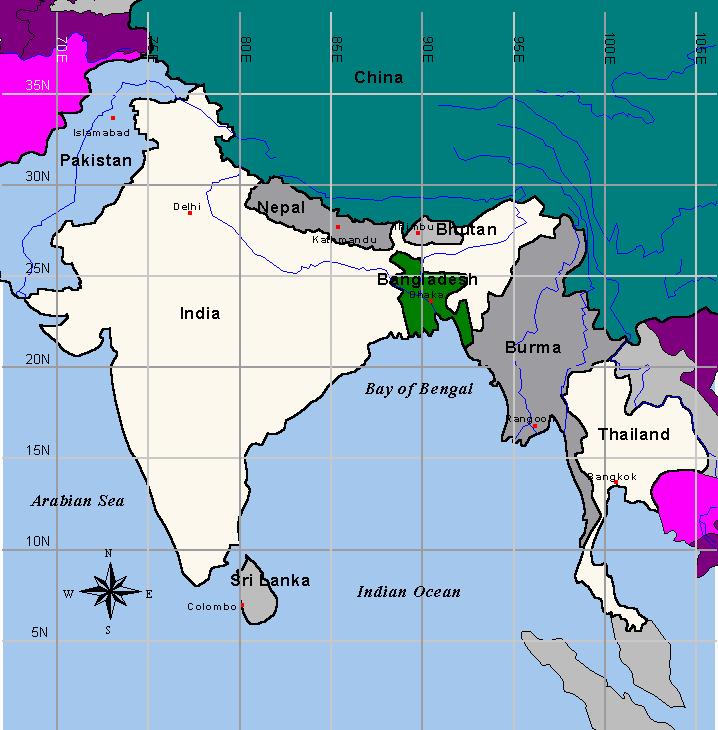
3 Mayanmar

4 The Ganges-Brahmaputra Brahmaputra-Meghna Basins Annual Sediment Transport The Ganges-Padma:886 Mtons The Brahmaputra: 600 Mtons The Meghna: 1 Mtons
 River floods b) Rainfall floods c) Flash floods d) Tidal")
5 Floods differ in location timing intensity duration Floods are of four types: a) River floods b) Rainfall floods c) Flash floods d) Tidal floods.
6 Yearly Flood Floods inundate about one-fifth of the country each year
7 Extreme Flood In extreme events, more than 60% of the country is flooded.
8 Flash Flood Pre-monsoon flash floods also occur in the NE, SE & Northern region
9 Tidal Flood Surge height >1m Surge height <1m The coastal areas of Bangladesh is susceptible to tidal floods.
10 Historical Flood Events Historical floods are not well recorded Professor Mahalnabish prepared report on 1922 flood This report says 25 floods occurred during floods were severe No dependable record available for period , except for 1931 flood Floods occurred after 1954 well recorded


11 Historical Flood Events Severe floods occurred in 1954, 55, 73, 87, 88, flood 1988 flood 1998 flood
12 YEAR Comparison of flooded area INUNDATED AREA (Sq. km) PERCENTAGE OF AREA (%) 1954 >50, , , , , , ,00, ,000 38

13 Flood Management Initiative 1954 flood Catastrophic floods of 1954 and 1955 led the Government to undertake flood control measures, following the recommendation of the Krugg Mission
14 countries flood management and drainage improvement. Presently the following skilled and supporting professionals At present BWDB is the major organization to deal with the are working under BWDB. Sl. No. Category Manpower Remarks 1 Engineer B.Sc Engineer Diploma 2 Water Management 59 3 Administrative Economic 20 5 Finance Audit & Accounts 61 6 Land & Revenue 17 7 Non Cadre (grade-1) 49 Sub Total Other Support Staff 7302 Total 8909 Excl. ME & Dredgers
15 Flood Management - Drainage Projects - Flood Control - Flood Control & Drainage - Flood Control, Drainage & Irrigation - Irrigation & Drainage 617 projects so far completed - Irrigation Projects 65% of flood prone lands now under flood management
16 FCDI Infrastructures Embankment : km Embankment Coastal : 5126 km Others : km Others Irrigation Canal : km Drainage Channels : km Hydraulic Structures : nos Barrages : 4 nos Pump houses : 19 nos Pumps : 100 nos River closures : 100 nos Roads : km Bridges & culverts : nos
17 Achievement in Flood Management Areas under Flood Management : 5.39 m ha Areas under irrigation facilities : 1.63 m ha Annual incremental food production due to flood management facilities : 7.8 m tons irrigation facilities : 3.2 m tons
18 Water Resources in Bangladesh Surface Water Rivers Total river : 262 nos Transboundary river : 57nos Main River : 3nos Rainfall Annual average : 2320 mm It varies from 1100 mm in the West to 5690 mm in the North-east Groundwater Annual average recharge : 300 mm to 600 mm

19 Bangladesh - A Land of Calamities Flood Erosion SWMC
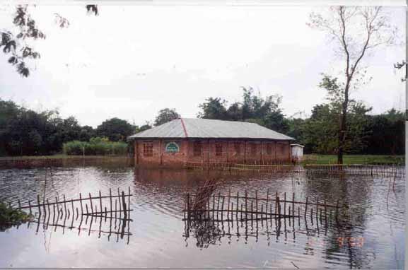
20 Flood

21 A Scene of Flooding in Haor

22 Inundation in 2000 : Sagarkhali Basin


23 Flood in Urban Areas Disruption to economic activities, Damage to vital installations


24

25
26 River Erosion Erosion is a very common phenomenon in all the river systems in Bangladesh About 100 sq km is eroded every year Erosion is very acute in the Brahmaputra - Jamuna, annually on average 300m erosion take place all along left river bank

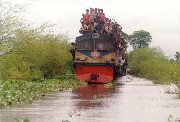
27 Chandpur Town

28 Chandpur Town

29 River Erosion


30 Bank Erosion of the Jamuna threatens a school & village, a common phenomenon of the rivers in Bangladesh
31 Bankline 1997 Bankline 2001 Ganges River 2Km


 of")
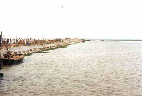
32 River Bank Protection Project Bhuapur Hardpoint Sirajganj Hardpoint East Guide Bund, Kalihati West Guide Bund, Sidabad Work Harbor SPOT Image (1999) of Jamuna Bridge Site


33 River training works

34 Agency initiatives for City drainage

35 Agency initiatives Photos on 27th July 2004

36 Peoples initiatives during severe flooding Photos on 25th July 2004
37 Management Options for Flood Flood Proofing & Zoning Improved Flood Forecasting & Warning System Improved Communications Relief and Rehabilitation Hazard preparedness Management Options for Erosion Low Cost Erosion Control Measures Erosion Forecasting & Warning System
38 Future Improvement Financing (loan, insurance etc.) Workable institutional arrangements Risks and uncertainties Regionality Integrated approach for the improvement
39 Institutional Development Following the floods of 1987 & 88, the Government has undertaken FAP studies National Water & Flood Management Strategy National Water Policy National Water Management Plan Guidelines for Participatory Water Management
40 Institutional Development BWDB Act 2000 Conforms to National Water Policy Separation of policy & oversight functions from operational management Ownership transfer of small projects (less than 1000 ha) Management transfer of medium projects (1000 to 5000 ha) Joint Management of Larger Projects
41 Flood Management Strategy Past flood management measures mainly focused on protection of agricultural lands. Present Present focus on integrated water management encompassing all sectoral interests.
42 Issues of Institutional Development Internalization of BWDB s ongoing reforms Following GPWM, an act needs to be enacted for regulating the activities of WMOs
43 Observations FCD schemes could achieve its primary goal Increasing intensity of floods calls for changing design criteria
44 Observations Constant vigilant by BWDB officials and the public helped in taking corrective measures to protect the embankments in time Railways, highways, roads etc, constructed across the flood plains, obstructed timely drainage of flood flows.
45 Recommendations Rationalising of Existing FCD Infrastructure need to be taken Integrated river Basin Management Flood risks zones should be designated Safe conveyance of the large cross-boundary flows by channelising and stabilizing these rivers with appropriates measures Excavation and desilting of rivers, khals, offtakes of distributaries etc Rivers, khals and floodways may be kept free from encroachment for free flood flows. Full flood protection and proper drainage for the urban areas
46 Recommendations Required fund may be ensured for the maintenance Revolving fund for emergency flood fighting Coordinated planning, design and construction of all rural roads, highways and railway embankments Adequate on-the the-spot security for the personnel engaged in flood fighting Legislation to regulate the community participation in O&M activities Water Act may be enacted to regulate all water management activities Improved flood forecasting system
47 THANK YOU EVERYBODY
Adaptation Policies and the Application to Urban Development in South Asia
 Adaptation Policies and the Application to Urban Development in South Asia (Norio Saito), Ph.D Principal Urban Development Specialist Urban Development and Water Division South Asia Department Asian Development
Issues Options and Strategies for Flood Management : Shifts in approaches for flood Management in Bangladesh
 Issues Options and Strategies for Flood Management : Shifts in approaches for flood Management in Bangladesh Ainun Nishat and Raquibul Amin Bangladesh Country Office Flooding: disaster or fact of life?
Md. Khairul Islam Executive Engineer, Bangladesh Water Development Board, Dhaka, Bangladesh.
 ASIA WATER CYCLE SYMPOSIUM 2016 ICHARM S CAPACITY BUILDING: CHALLENGES AND FUTURE PROSPECTS REGARDING WATER-RELATED RELATED ISSUES IN BANGLADESH Md. Khairul Islam Executive Engineer, Bangladesh Water Development
Partnerships with Coastal Communities in Building Climate Resilient Infrastructures in Bangladesh. Md Habibur Rahman Superintending Engineer
 Partnerships with Coastal Communities in Building Climate Resilient Infrastructures in Bangladesh Md Habibur Rahman Superintending Engineer Geographical Location of Bangladesh Bangladesh Bangladesh Largest
Climate Change, Climate variability and Water Management
 Climate Change, Climate variability and Water Management Ainun Nishat Ph.D. Country Representative, Bangladesh IUCN, the International Union for Conservation of Nature From Water and Climate Change: IPCC
Impact of climate change on disasters and agriculture in Bangladesh
 Regional Conference on Climate Change: Challenges and Opportunities for South Asia Islamabad, Pakistan January 13 14, 2009 Impact of climate change on disasters and agriculture in Bangladesh Ahmadul Hassan
Process Development for Hydrological Regionwide Integrated Water Resources Management Model in Bangladesh
 Asian Journal of Applied Science and Engineering, Volume 4, No 2/2015 ISSN 2305-915X(p); 2307-9584(e) Process Development for Regionwide Integrated Water Resources Management Model in Bangladesh Md. Masud
Tennessee Technological University
 Understanding Surface Water Flow and Tennessee Storage Changes Technological using Satellites: Emerging Opportunities for Bangladesh Faisal Hossain Department of Civil and Environmental Engineering nological
SUBSECTOR ASSESSMENT (SUMMARY): FLOOD PROTECTION
: FLOOD PROTECTION") Sector Road Map Assam Integrated Flood and Riverbank Erosion Risk Management Investment Program (RRP IND 38412) SUBSECTOR ASSESSMENT (SUMMARY): FLOOD PROTECTION 1. Sector Performance, Problems, and Opportunities
Sector Road Map Assam Integrated Flood and Riverbank Erosion Risk Management Investment Program (RRP IND 38412) SUBSECTOR ASSESSMENT (SUMMARY): FLOOD PROTECTION 1. Sector Performance, Problems, and Opportunities
Flood Inundation Mapping of Floodplain of the Jamuna River Using HEC-RAS and HEC-GeoRAS. M. M. Rahman* 1, M. M. Ali 2
 Paper ID: WRE-42 14 International Conference on Recent Innovation in Civil Engineering for Sustainable Development () Department of Civil Engineering DUET - Gazipur, Bangladesh Flood Inundation Mapping
Dr. M. Monowar Hossain, Executive Director Institute of Water Modelling (IWM) & Coordinator, Delta Alliance Bangladesh Wing (DABW)
 & Coordinator, Delta Alliance Bangladesh Wing (DABW)") Dr. M. Monowar Hossain, Executive Director Institute of Water Modelling (IWM) & Coordinator, Delta Alliance Bangladesh Wing (DABW) Paper presented at Delta Coalition Ministerial Conference and Working
Dr. M. Monowar Hossain, Executive Director Institute of Water Modelling (IWM) & Coordinator, Delta Alliance Bangladesh Wing (DABW) Paper presented at Delta Coalition Ministerial Conference and Working
Flood Inundation Mapping of Floodplain of the Jamuna River Using HEC-RAS and HEC-GeoRAS
 1 @2016 Journal of PU, Part: B Vol. 3 No:2, July 2016 pp 24-32 PRESIDENCY UNIVERSITY ISSN: 2224-7610 Flood Inundation Mapping of Floodplain of the Jamuna River Using HEC-RAS and HEC-GeoRAS ABSTRACT *M.
Md. Mahfuzur Rahman Additional Director General (West Region), BWDB, Dhaka
, BWDB, Dhaka") Md. Mahfuzur Rahman Additional Director General (West Region), BWDB, Dhaka Bangladesh Bangladesh surrounded on the east, north and west by India, by Mynamar on southeast and by Bay of Bengal on south.
Md. Mahfuzur Rahman Additional Director General (West Region), BWDB, Dhaka Bangladesh Bangladesh surrounded on the east, north and west by India, by Mynamar on southeast and by Bay of Bengal on south.
1.3 FCDI Chronology Water Sector in Bangladesh
 1.3 FCDI Chronology 1.3.1 Water Sector in Bangladesh Bangladesh, a land of about 144,000 sqkm, is one of the largest delta of the world, formed by the most complex river system of the Ganges, the Brahmaputra
Participatory Water Management Approach in Bangladesh
 Abstract: Participatory Water Management Approach in Bangladesh Giasuddin Ahmed Choudhury P.Eng, Chief Engineer, O&M, Bangladesh Water Development Board, Ministry of Water Resources, gac@bttb.net.bd In
Performance Evaluation of FCD/FCDI Projects During the 1998 Flood
 M. A. Ali, S. M. Seraj and S. Ahmad (eds): ISBN 984-823-002-5 Performance Evaluation of FCD/FCDI Projects During the 1998 Flood A.F.M. Saleh, S.M.U. Ahmed, M.R. Rahman, M. Salehin, and M.S. Mondal Institute
Climate Change, Food and Water Security in Bangladesh
 12 29 March 2016 Climate Change, Food and Water Security in Bangladesh Haweya Ismail Research Analyst Global Food and Water Crises Research Programme Key Points Bangladesh s geographical location, poverty
Climate and Disaster Risk Screening Report for General Project in Bangladesh: Hypothetical Education Project 1
 Climate and Disaster Risk Screening Report for General Project in Bangladesh: Hypothetical Project 1 1 This is the output report from applying the World Bank Group's Climate and Disaster Risk Screening
ASSESSMENT OF TRENDS AND MAJOR DRIVERS OF WATER POLICY TO INFORM SCENARIO DEVELOPMENT FOR INTEGRATED WATER RESOURCES MANAGEMENT IN BANGLADESH
 ASSESSMENT OF TRENDS AND MAJOR DRIVERS OF WATER POLICY TO INFORM SCENARIO DEVELOPMENT FOR INTEGRATED WATER RESOURCES MANAGEMENT IN BANGLADESH Catharien Terwisscha van Scheltinga Catharien.Terwisscha@wur.nl
Implications of Climate Change on Water Management in Bangladesh
 Implications of Climate Change on Water Management in Bangladesh February 6, 28 Jahir Uddin Chowdhury Professor Institute of Water and Flood Management BUET, Dhaka-1, Bangladesh 1. Introduction Bangladesh
Flood, Rainfall, River Situation and Summary of Water Levels
 Disaster Management Information Centre Disaster Management Bureau (DMB) Ministry of Food and Disaster Management Disaster Management and Relief Bhaban (6 th Floor) 92-93 Mohakhali C/A, Dhaka-1212, Bangladesh
Water Resources ENV 107
 Water Resources ENV 107 Freshwater is an irreplaceable Resource Access to water is A global health issue An economic issue A women s and children s issue A national and global security issue Most of the
Climate change science, knowledge and impacts on water resources in South Asia
 Climate change science, knowledge and impacts on water resources in South Asia DIAGNOSTIC PAPER 1 GUILLAUME LACOMBE, PENNAN CHINNASAMY Regional Conference on Risks and Solutions: Adaptation Frameworks
Transboundary Conservation of the mangrove ecosystem of Sundarbans
 Transboundary Conservation of the mangrove ecosystem of Sundarbans BANGLADESH Laskar Muqsudur Rahman Forest Department, BANGLADESH E-mail: laskarmr@yahoo.com Third Workshop on Water and Adaptation to Climate
Japanese ODA Loan. Ex-Ante Evaluation
 Japanese ODA Loan Ex-Ante Evaluation 1. Project Country: People's Republic of Bangladesh Name of the Project: Haor Flood Management and Livelihood Improvement Project Loan Agreement: June 16, 2014 Loan
Adaptation to climate change and social justice: challenges for flood and disaster management in Thailand
 Adaptation to climate change and social justice: challenges for flood and disaster management in Thailand 2008 Berlin Conference on the Human Dimensions of Global Environmental Change 21-22 February 2008
An Analytical Study of Flood Management in Bangladesh
 IOSR Journal of Engineering (IOSRJEN) ISSN (e): 2250-3021, ISSN (p): 2278-8719 Vol. 04, Issue 01 (January. 2014), V7 PP 01-06 www.iosrjen.org An Analytical Study of Flood Management in Bangladesh Dr. Md.
FLOOD Analysis And Development of Groundwater Recharge and Discharge Estimate Maps using GIS
 FLOOD Analysis And Development of Groundwater Recharge and Discharge Estimate Maps using GIS Dr. Ghulam Nabi Assistant Professor Center of Excellence in Water Resources Engineering, g University of Engineering
Member s Annual Report 2007 Date of preparation: 12 / 04 /2008 Name of the editor: Emaduddin Ahmad
 Member s Annual Report Date of preparation: 12 / 04 /2008 Name of the editor: Emaduddin Ahmad 1. About the organization (1) Name of the organization and postal address of the office Institute of Water
CORFU PROJECT EXPERIENCE FROM THE RAPIDLY DEVELOPING CITY OF DHAKA, BANGLADESH
 CORFU PROJECT EXPERIENCE FROM THE RAPIDLY DEVELOPING CITY OF DHAKA, BANGLADESH S M Mahbubur Rahman 1,*, David M Khan 1, Abu Saleh Khan 1, M Monowar Hossain 1 1 Institute of Water Modelling, Bangladesh;
Making. Integrated Flood Management. Part of the Development Agenda. IWRM and FLOODS
 Making Integrated Flood Management Part of the Development Agenda IWRM and FLOODS The challenge Our planet s water resources are vital for sustainable development. Floods play a major role in replenishing
I. THE ROLE OF FLOOD HAZARD MAPS TO MITIGATE FLOOD DAMAGE IN MALAYSIA
 I. THE ROLE OF FLOOD HAZARD MAPS TO MITIGATE FLOOD DAMAGE IN MALAYSIA A.1 Flood Status in Malaysia Malaysia has along history of flooding, the country being exposed to monsoon winds and heavy conventional
Effects of sluice gate on fisheries and crops production at Jugini CPP Area, Tangail, Bangladesh
 International Journal of Biosciences IJB ISSN: 2220-6655 (Print) 2222-5234 (Online) http://www.innspub.net Vol. 4, No. 8, p. 8-13, 2014 RESEARCH PAPER OPEN ACCESS Effects of sluice gate on fisheries and
SOUTH ASIA HYDROMET FORUM SESSION 5: LINKING COMMUNITIES TO WEATHER AND CLIMATE SERVICE
 SOUTH ASIA HYDROMET FORUM SESSION 5: LINKING COMMUNITIES TO WEATHER AND CLIMATE SERVICE Dr. Mazharul Aziz Project Director Agro-Meteorological Information Systems Development Project (Component-C of Bangladesh
Thai Government Response to the 2011 Floods. Asst.Prof. Sathaporn Opasanon (PhD) Thammasat Business School
 Thammasat Business School") Thai Government Response to the 2011 Floods Asst.Prof. Sathaporn Opasanon (PhD) Thammasat Business School opasanon@gmail.com, opasanon@tu.ac.th What happened in 2011? Consequences 6 months (July, 2011
Thai Government Response to the 2011 Floods Asst.Prof. Sathaporn Opasanon (PhD) Thammasat Business School opasanon@gmail.com, opasanon@tu.ac.th What happened in 2011? Consequences 6 months (July, 2011
Partha J Das Water Climate and Hazard Programme AARANYAK Guwahati Cell:
 Conflicts over water induced hazards and their management: Perspectives from Assam Training Workshop on Understanding and Resolving Water Conflicts in NE India) Organised by Forum for Policy Dialogue on
AFloodForecastingModelfortheRiverPadma
 Global Journal of Researches in Engineering: e Civil And Structural Engineering Volume 14 Issue 6 Version 1.0 Year 2014 Type: Double Blind Peer Reviewed International Research Journal Publisher: Global
Note that the Server provides ArcGIS9 applications with Spatial Analyst and 3D Analyst extensions and ArcHydro tools.
 Remote Software This document briefly presents the hydrological and hydraulic modeling software available on the University of Nice Server with Remote Desktop Connection. Note that the Server provides
HYDRAULICS DIVISION. Assoc. Prof. Dr. Mustafa ERGİL. Assoc. Prof. Dr. Umut TÜRKER
 HYDRAULICS DIVISION Assoc. Prof. Dr. Mustafa ERGİL Assoc. Prof. Dr. Umut TÜRKER HYDRAULICS AND C.E. Civil Engineers plan, design and construct: new harbors and waterways, pipelines, irrigation and drainage
FLOOD MANAGEMENT IN THE RED THAI BINH RIVER BASIN VIET NAM
 FLOOD MANAGEMENT IN THE RED THAI BINH RIVER BASIN VIET NAM By Dr. To Trung Nghia Director of Institute of Water Resources Planning Chief of the Red Thai Binh RBO Office E-mail: iwrp.hanoi@hn.vnn.vn INTRODUCTION
The Role and Opportunities Of Water Environment in the. Republic of the Union of Myanmar
 The Role and Opportunities Of Water Environment in the Republic of the Union of Myanmar Presented by SOE MYINT Director General (Rtd;) Directorate of Water Resources and Improvement of River Systems (DWIR)
The 9th Disaster Risk Management Seminar
 The 9th Disaster Risk Management Seminar "Integrated Urban Flood Risk Management: Obstacles and Opportunities in East Asia-Pacific and Lessons from Japan" INSTITUTIONAL FRAMEWORK, CHALLENGES IN VIETNAM
Rutherglen (Potentially Vulnerable Area 11/14) Local Plan District Clyde and Loch Lomond Local authority Glasgow City Council, South Lanarkshire Counc
 Local Plan District Clyde and Loch Lomond Local authority Glasgow City Council, South Lanarkshire Counc") Rutherglen (Potentially Vulnerable Area 11/14) Local Plan District Clyde and Loch Lomond Local authority Glasgow City Council, South Lanarkshire Council Main catchment Cityford Burn Summary of flooding
Rutherglen (Potentially Vulnerable Area 11/14) Local Plan District Clyde and Loch Lomond Local authority Glasgow City Council, South Lanarkshire Council Main catchment Cityford Burn Summary of flooding
Roadmap toward Effective Flood Hazard Map in Lampang Thailand. JICA region-focused training course on flood hazard mapping JFY 2005
 Roadmap toward Effective Flood Hazard Map in Lampang Thailand JICA region-focused training course on flood hazard mapping JFY 2005 Prepared by MR. SOMCHIT AMNATSAN Chief of Water Planning and Solution
RIVER BASIN PADMA [ BANGLADESH ]
![RIVER BASIN PADMA [ BANGLADESH ]](/thumbs/94/118208652.jpg "RIVER BASIN PADMA [ BANGLADESH ]") RIVER BASIN PADMA [ BANGLADESH ] SCHEDULE A ASSESSMENT OF RIVER BASINS (RBs) IN SOUTH ASIA Sr. No Details Response 1.1 Name of River basin (also indicate regional The Ganges-Padma River (known as the Ganges
RIVER BASIN PADMA [ BANGLADESH ] SCHEDULE A ASSESSMENT OF RIVER BASINS (RBs) IN SOUTH ASIA Sr. No Details Response 1.1 Name of River basin (also indicate regional The Ganges-Padma River (known as the Ganges
4.6 Site conditions General
 4.6 Site conditions 4.6.1 General The Project site is located approximately 150km northwest from Dhaka, adjacent to north boundary of the existing Bheramara Thermal Power Plant approximately 20km northwest
The Lower Watershed Ecosystem Services in Coastal Areas with a focus on the Courtenay River Floodplain
 The Lower Watershed Ecosystem Services in Coastal Areas with a focus on the Courtenay River Floodplain Jennifer Sutherst Estuary Coordinator and Staff Biologist Comox Valley Project Watershed Society Lower
Utilization and Conservation of Water Resources in Bangladesh
 Utilization and Conservation of Water Resources in Bangladesh Abu Musa Md. Motaher AHMED 1, Ph.D and Kingshuk ROY, Ph.D 2 1 Senior Scientific Officer, River Research Institute, Faridpur 7800, Bangladesh
Regional Cooperation for Flood Disaster Mitigation in the Hindu Kush-Himalayan Region
 Regional Cooperation for Flood Disaster Mitigation in the Hindu Kush-Himalayan Region International Centre for Integrated Mountain Development Khumaltar, Lalitpur, P.O. Box 3226, Kathmandu, Nepal Tel:
Bangladesh Climate Change Resilience Fund (BCCRF) And The Development Economics Research Group Present
 And The Development Economics Research Group Present") Bangladesh Climate Change Resilience Fund (BCCRF) And The Development Economics Research Group Present Urban Flooding of Greater Dhaka in a Changing Climate Building Local Resilience to Disaster Risk Susmita
Bangladesh Climate Change Resilience Fund (BCCRF) And The Development Economics Research Group Present Urban Flooding of Greater Dhaka in a Changing Climate Building Local Resilience to Disaster Risk Susmita
Good Practices in Addressing Climate Change Adaptation Deficits due to Extreme Climate Events Perspectives from Asia. Ramasamy Selvaraju
 Good Practices in Addressing Climate Change Adaptation Deficits due to Extreme Climate Events Perspectives from Asia Ramasamy Selvaraju Hazard and Vulnerability Asian region accounts for 40% of the total
Utilization and Conservation of Water Resources in Bangladesh
 Journal of Developments in Sustainable Agriculture,: -/.. (,**1) Utilization and Conservation of Water Resources in Bangladesh Abu Musa Md. Motaher Ahmed + and Kingshuk Roy, + Senior Scientific O$cer,
Strengthening Resilience of Water Supply and Sanitation to Climate Change in Coastal Towns of Bangladesh
 4 th Asia Pacific Adaptation Forum Kuala Lumpur, Malaysia, 1-3 October 2014 Strengthening Resilience of Water Supply and Sanitation to Climate Change in Coastal Towns of Bangladesh Ron H. Slangen Urban
ITS MANAGEMENT IN MALAYSIA DEPARTMENT OF IRRIGATION AND DRAINAGE
 WATER RELATED DISASTER AND ITS MANAGEMENT IN MALAYSIA FLOODS BACKGROUND INTRODUCTIONS WATER RELATED DISASTERS IN MALAYSIA FLOODS LANDSLIDES DROUGHT TSUNAMIES FLOODS LANDSLIDES (DID) To provide engineering
INTERNATIONAL SYMPOSIUM ON HARMONISING ENVIRONMENTAL CONSIDERATIONS WITH SUSTAINABLE DEVELOPMENT POTENTIAL OF RIVER BASINS.
 INTERNATIONAL SYMPOSIUM ON HARMONISING ENVIRONMENTAL CONSIDERATIONS WITH SUSTAINABLE DEVELOPMENT POTENTIAL OF RIVER BASINS 24-26 March 2010 IRBM in Malaysia DID Initiatives by Department of Irrigation
Use of Space-based Systems for Water Resources Management In India
 49 th Session of UN-COPUOS (7-16 June 2006) Agenda Item 12: Space and Water Use of Space-based Systems for Water Resources Management In India Presentation by Dr. K. Radhakrishnan Indian Delegation . we
Decision-making under Deep Uncertainty Conference 2017
 Decision-making under Deep Uncertainty Conference 2017 BANGLADESH DELTA PLAN 2100 A challenge in meeting the uncertainties of long-term planning Giasuddin Choudhury Oxford, 15 November, 2017 Background
INTEGRATED FLOOD MANAGEMENT IN SAMOA
 INTEGRATED FLOOD MANAGEMENT IN SAMOA From Science to Policy Amataga Penaia 1, Ausetalia Titimaea 1, Jude Kohlhase 1, Filomena Nelson 1, Netatua Pelesikoti 2, Michael Bonte-Grapentin 2, Litea Biukoto 2,
Mainstreaming Climate Change Adaptation into the World Bank s Operational Work. Lessons learned from ADAPTATION TO CLIMATE CHANGE IN BANGLADESH
 Mainstreaming Climate Change Adaptation into the World Bank s Operational Work Lessons learned from ADAPTATION TO CLIMATE CHANGE IN BANGLADESH Prepared by Saleemul Huq Director Climate Change Programme
Conflict resolution and institutional arrangements for flood disaster management on Indo Nepal fringe: Focus on Kosi basin
 Conflict resolution and institutional arrangements for flood disaster management on Indo Nepal fringe: Focus on Kosi basin N.M.P. Verma 15 Ambedkar University Introduction Trans-boundary conflict is one
Effect of Flood on Earth Structures: A Case Study
 M. A. Ali, S. M. Seraj and S. Ahmad (eds): ISBN 984-823-002-5 Effect of Flood on Earth Structures: A Case Study M. A. Ansary and A. M. M. Safiullah Department of Civil Engineering Bangladesh University
Policy of Water related Disaster Preparedness in Indonesia
 Policy of Water related Disaster Preparedness in Indonesia by : Imam Santoso Director General for Water Resources Ministry of Public Works and Housing 1. Potency of Water Resources in Indonesia INDONESIA
Chapter 11 Culverts and Bridges
 Chapter 11 Culverts and Bridges Contents 1.0 Introduction... 1 2.0 General Design... 1 2.1 Design Criteria... 1 2.2 Design Flows... 1 2.3 Permitting and Regulations... 1 2.4 Aesthetics and Safety... 2
Environmental and Social Impact of Flood Control, Drainage and Irrigation projects: Is it a Development Disaster for Bangladesh???
 Environmental and Social Impact of Flood Control, Drainage and Irrigation projects: Is it a Development Disaster for Bangladesh??? Manik Kumar Saha Young Professional, BRAC Email: manik.0415009@gmail.com
BAN: Irrigation Management Improvement Project
 Irrigation Management Improvement Project (RRP BAN 45207) Initial Environmental Examination Project Number: 45207 February 2014 BAN: Irrigation Management Improvement Project Prepared by TA 8154: Preparing
Numerical Analysis on Seepage through Earthen Embankment Protected by Cement Concrete Block (CC Block) in Bangladesh
 in Bangladesh") American Journal of Civil Engineering and Architecture, 2016, Vol. 4, No. 5, 181-188 Available online at http://pubs.sciepub.com/ajcea/4/5/5 Science and Education Publishing DOI:10.12691/ajcea-4-5-5 Numerical
American Journal of Civil Engineering and Architecture, 2016, Vol. 4, No. 5, 181-188 Available online at http://pubs.sciepub.com/ajcea/4/5/5 Science and Education Publishing DOI:10.12691/ajcea-4-5-5 Numerical
AERIAL PHOTO OF A FLOOD PLAIN Dr. Martin Falke
 FMMP C 5 & FLOOD INFORMATION BASED LAND MANAGEMENT (FIBLM) by AERIAL PHOTO OF A FLOOD PLAIN Dr. Martin Falke Team Leader (GFA-Consulting Group) MRC (FMMP) Land Management Component (C 5) Regional Flood
PROJECT INFORMATION DOCUMENT (PID) APPRAISAL STAGE Report No.: PIDA Project Name Region Country Sector(s) Theme(s)
 APPRAISAL STAGE Report No.: PIDA Project Name Region Country Sector(s) Theme(s)") Public Disclosure Authorized Public Disclosure Authorized Public Disclosure Authorized Public Disclosure Authorized Project Name Region Country Sector(s) Theme(s) Lending Instrument Project ID Borrower(s)
Public Disclosure Authorized Public Disclosure Authorized Public Disclosure Authorized Public Disclosure Authorized Project Name Region Country Sector(s) Theme(s) Lending Instrument Project ID Borrower(s)
(1) Bridge, Road and Railway (Adaptation Project) (2) Bridge, Road and Railway (BAU Development with Adaptation Options)
 Bridge, Road and Railway (Adaptation Project) (2) Bridge, Road and Railway (BAU Development with Adaptation Options)") Sub-sector Guideline: (1) Bridge, Road and Railway (Adaptation Project) (2) Bridge, Road and Railway (BAU Development with Adaptation Options) Basic Concept A. General Concept Climate change will increase
Sub-sector Guideline: (1) Bridge, Road and Railway (Adaptation Project) (2) Bridge, Road and Railway (BAU Development with Adaptation Options) Basic Concept A. General Concept Climate change will increase
Concept of Flood Shelter to Cope with Flood
 M. A. Ali, S. M. Seraj and S. Ahmad (eds): ISBN 984-823-002-5 Concept of Flood Shelter to Cope with Flood M. J. B. Alam and Md. Hossain Ali Department of Civil Engineering Bangladesh University of Engineering
Constraints Faced by the Fishermen in Flood Prone Areas of Jamalpur District. Abstract
 Bangladesh Journal of Constraints Extension Faced Education by the Fishermen in Flood Prone Areas: ISSN Alam 1011-3916 et al. 81 Volume 22, No. 1&2, 2010:81-86 Research Article Constraints Faced by the
PRESENTATION ON RIVER BASIN MANAGEMENT
 Welcome PRESENTATION ON RIVER BASIN MANAGEMENT Government of Karnataka,INDIA States of India Largest Democratic Country. 2nd Largest Populous. Population 1.18 Billion. 7th Largest By Area. Area 32,87,623
Appendix-7 River Engineering
 Appendix-7 River Engineering 7.1 INTRODUCTION 7.1.1 Necessity of River Study for Bridge Planning In order to avoid or alleviate the river-related problems of the bridge project, river studies should be
Dry Creek Flood Control Improvement Project
 Dry Creek Flood Control Improvement Project The following is a brief overview of the planned IRWM Stormwater Flood Management Grant Application from the Fresno Metropolitan Flood Control District (FMFCD)
GEOTECHNICAL HAZARD ANALYSIS OF RIVER EMBANKMENT OF BANGLADESH AND ITS PROTECTABILITY
 Geotec., Const. Mat. & Env., ISSN: 2186-2982(Print), 2186-2990(Online), Japan GEOTECHNICAL HAZARD ANALYSIS OF RIVER EMBANKMENT OF BANGLADESH AND ITS PROTECTABILITY Md. Wasif Zaman 1, Tansir Zaman Asik
Management Plan
 Rivers & Drainage Asset Heading/title Management Plan 2018-2068 Subheading Month Year Prepared by Bay of Plenty Regional Council 5 Quay Street P O Box 364 Whakatāne NEW ZEALAND Contents Document control
Prestwick and Ayr (Potentially Vulnerable Area 12/09) Local Plan District Ayrshire Local authority South Ayrshire Council Main catchment Doonfoot to M
 Local Plan District Ayrshire Local authority South Ayrshire Council Main catchment Doonfoot to M") Prestwick and Ayr (Potentially Vulnerable Area 12/09) Local Plan District Ayrshire Local authority South Ayrshire Council Main catchment Doonfoot to Monkton coastal Summary of flooding impacts At risk
Prestwick and Ayr (Potentially Vulnerable Area 12/09) Local Plan District Ayrshire Local authority South Ayrshire Council Main catchment Doonfoot to Monkton coastal Summary of flooding impacts At risk
The Case of Kurichu in the Indo-Bhutan Context
 The Case of Kurichu in the Indo-Bhutan Context Transboundary Hydropower Projects and Downstream Flooding Anjana Mahanta Description Hydropower development in Bhutan has gained considerable ground as a
2. DEFINITIONS. American Association of State Highway and Transportation Officials.
 2. DEFINITIONS 2.010 Definitions [See Amendment 2] In addition to words and terms that may be defined elsewhere in this manual, the following words and terms shall have the meanings defined below: AASHTO:
Irvine to Troon (Potentially Vulnerable Area 12/07) Local Plan District Local authority Main catchment North Ayrshire Council, Ayrshire Monkton to Irv
 Local Plan District Local authority Main catchment North Ayrshire Council, Ayrshire Monkton to Irv") Irvine to Troon (Potentially Vulnerable Area 12/07) Local Plan District Ayrshire Local authority North Ayrshire Council, South Ayrshire Council Main catchment Monkton to Irvine coastal Summary of flooding
Irvine to Troon (Potentially Vulnerable Area 12/07) Local Plan District Ayrshire Local authority North Ayrshire Council, South Ayrshire Council Main catchment Monkton to Irvine coastal Summary of flooding
STATE WATER POLICY. 1. The Need for a State Water Policy
 STATE WATER POLICY 1. The Need for a State Water Policy Water is a prime natural resource, a basic human need and a precious asset of the State. Planning, development, operation and maintenance of all
ODOT Floodplain Management. Jeffrey Syar, P.E., Administrator, Central Office,Hydraulic Engineering
 ODOT Floodplain Management Jeffrey Syar, P.E., Administrator, Central Office,Hydraulic Engineering John R. Kasich, Ohio Governor Jerry Wray, ODOT Director Background NFIP Ohio Department of Natural Resource
MISSISSIPPI RIVER AND TRIBUTARIES PROJECT
 MISSISSIPPI RIVER AND TRIBUTARIES PROJECT 1 237 237 237 217 217 217 200 200 200 80 119 27 252 174.59 255 255 255 0 0 0 163 163 163 131 132 122 239 65 53 110 135 120 112 92 56 62 102 130 102 56 48 130 120
Climate Change Adaptation Case Example: Adaptation in Bangladesh
 Climate Change Adaptation Case Example: Adaptation in Bangladesh Dr. Atiq Rahman Executive Director: Bangladesh Centre for Advanced Studies (BCAS) Founding Chairman: Climate Action Network South Asia (CANSA)
Latest tools and methodologies for flood modeling
 Latest tools and methodologies for flood modeling Dr. Yuri Simonov Senior scientist, Hydrometcentre of Russia WMO Commission for Hydrology AWG member Floods - background Types of water-related natural
CHARACTERIZATION OF OPEN CHANNEL FLOW PARAMETERS OF THE RIVER GORAI
 Proceedings of the 3 rd International Conference on Civil Engineering for Sustainable Development (ICCESD 2016), 12~14 February 2016, KUET, Khulna, Bangladesh (ISBN: 978-984-34-0265-3) CHARACTERIZATION
Reducing flood devastation in the Nile Basin
 102253 BRIEFING NOTE 7 Reducing flood devastation in the Nile Basin A regional cooperation effort coordinated by the Nile Basin Initiative (NBI) has created a credible system that links multiple stakeholders
2014/2015 Rivers and Drainage Asset Management Plan
 2014/2015 Rivers and Drainage Asset Management Plan Executive Summary Title Title part 2 Bay of Plenty Regional Council 5 Quay Street PO Box 364 Whakatāne 3158 NEW ZEALAND Document control Document information
TOWN LINE BROOK URBAN WATERSHED STUDY MODELING INCREMENTAL IMPROVEMENTS
 TOWN LINE BROOK URBAN WATERSHED STUDY MODELING INCREMENTAL IMPROVEMENTS Marcus M. Quigley, P.E., Project Engineer, GeoSyntec Consultants Steven P. Roy, Associate, GeoSyntec Consultants Lawrence Gil, North
AERIAL PHOTO OF A FLOOD PLAIN Dr. Martin Falke
 FMMP-C 5 Flood Management and Mitigation Programme - Land Management Component - FMMP C 5 & FLOOD INFORMATION BASED LAND MANAGEMENT (FIBLM) by AERIAL PHOTO OF A FLOOD PLAIN Dr. Martin Falke Team Leader
INTENSE STORM-RUNOFF ROUTING OF HATIRJHEEL-BEGUNBARI LAKE OF DHAKA CITY
 Proceedings of the 3 rd International Conference on Civil Engineering for Sustainable Development (ICCESD 2016), 12~14 February 2016, KUET, Khulna, Bangladesh (ISBN: 978-984-34-0265-3) INTENSE STORM-RUNOFF
Bangladesh: Emergency Flood Damage Rehabilitation Project
 Validation Report Reference Number: PCV: BAN 2009-16 Project Number: 38625 Loan Number: 2156-BAN (SF) December 2009 Bangladesh: Emergency Flood Damage Rehabilitation Project Independent Evaluation Department
Investing in Water Disaster Management: Before and After
 Investing in Water Disaster Management: Before and After Wouter Lincklaen Arriëns Lead Water Resources Specialist Asian Development Bank 2 December 2007 Outline of Presentation Realities and Trends ADB
Hydrology Attribute 1/15/2016. California Rapid Assessment Method for Wetlands. Hydrology. Precipitation Increases the Extent of Wetlands
 California Rapid Assessment Method for Wetlands Hydrology Attribute Hydrology Determines existence of wetlands, drives primary physical and ecological processes: Establishment of reducing conditions Nutrient
Exploring Flood Mitigation Strategies in Bangladesh
 University of New Mexico UNM Digital Repository Water Resources Professional Project Reports Water Resources 4-5-2010 Exploring Flood Mitigation Strategies in Bangladesh Pallab Mozumder Follow this and
Capacity Building for Urban Disaster Preparedness and Climate Change Mitigation
 Capacity Building for Urban Disaster Preparedness and Climate Change Mitigation Presenter Kazi Samiul Hoque Urban Planner at Habitat Planning Associates Ltd. Registered Town Planner (RAJUK) sazal.planner@gmail.com
OPTIONS FOR FLOODS AND DROUGHT PREPAREDNESS IN BANGLADESH
 OPTIONS FOR FLOODS AND DROUGHT PREPAREDNESS IN BANGLADESH Dr Nehal Karim 1 Abstract: Bangladesh is a small country of 147,570 sq. km. with a huge population, the density of population is 855 per sq. km.
Hydrology and Flooding
 Hydrology and Flooding Background The 1996 flood Between February 4, 1996 and February 9, 1996 the Nehalem reporting station received 28.9 inches of rain. Approximately 14 inches fell in one 48 hour period.
Implications of Biophysical Trajectory for policy Decision in the Ganges Brahmaputra Meghna Delta
 Implications of Biophysical Trajectory for policy Decision in the Ganges Brahmaputra Meghna Delta ESPA Delta- Assessing Health, Livelihoods, Ecosystem Services and Poverty Alleviation in Populous Deltas