Groundwater Flow Demonstration Model Activities for grades 4-12
|
|
|
- Arthur Hubbard
- 5 years ago
- Views:
Transcription


1 Groundwater Flow Demonstration Model Activities for grades 4-12 NR/WQ/2012-5


2 SET-UP Please allow time to practice using the groundwater model before conducting demonstrations. 1. Remove the groundwater model from the case and use the two wooden blocks to stand it up. 2. Fill two one-quart wide-mouth bottles with water. Secure the rubber stopper with tubing at the mouth of each bottle. 3. Mix up blue and green solutions. Fill two of the 125ml squirt bottles with water. Add one drop of green to one of the bottles and one drop of blue to the other. 4. Twist the lids on tightly and swirl the bottles to mix in the dye. Cover the spout with a finger while mixing to prevent spilling. 5. Set-up pump as shown in picture. Figure 1: Groundwater model and materials CLEAN-UP 1. Use the hand pump in order to remove water and dye. You may need to run more water through the model in order to flush out all of the dye. Pump from the channels at either end of the model and from the piezometers and wells. 2. Leave the model out to air dry overnight. Figure 2: Water pump setup 1

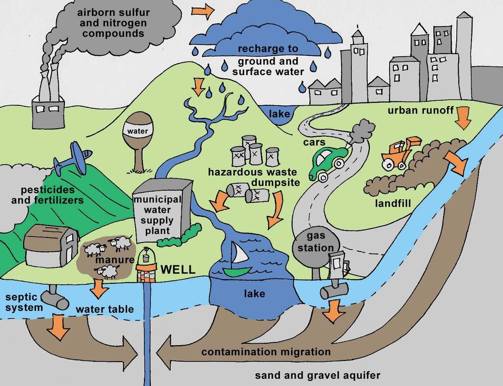
3 Groundwater Contamination Lesson PURPOSE: To introduce students to the basics of groundwater and how contaminants move into groundwater. SUMMARY: By watching a demonstration with a groundwater model, students learn what groundwater is, how it moves, and how contaminants may enter groundwater. Suggested grade level: 4-12 BACKGROUND: Many people assume that water exists in lakes and rivers beneath the ground. These underground lakes and rivers rarely exist. Groundwater is water found underground that fills in the pore spaces of sediments. Groundwater is stored in the pore spaces of saturated soil, between sand grains, and inside cracks and fractures in rock. An underground unit of soil, sand, gravel, or fractured rock which can yield a significant quantity of groundwater to wells is called an aquifer. Humans pump water out of aquifers for drinking purposes, irrigation and other water uses. Contaminants normally enter aquifers from the surface. Examples of some groundwater contaminants are oil and gas, fertilizer, pesticides and other harmful chemicals. Once the contamination reaches the aquifer it can move quickly through the aquifer and come out in wells, or in rivers, lakes, or other water bodies. The environment cannot quickly and easily get rid of contaminants. In many places water only moves a few feet a year, so contaminants will remain in the aquifer for many years. Soil types can play a role in groundwater contamination. Clays and silts can hold more water than sand. Therefore, water and contaminants in water can pass through sand more easily than clays or silts. Duration: 20 minutes Setting: Classroom Outdoors Abandoned wells can be contaminated by human activities at or near the land surface. Since wells create a cone of depression around them as they draw water, they can also draw contaminants toward them from any direction: above, below, or even the area that would normally be considered "downstream". One must know the characteristics of soils and chemicals to manage human activities and reduce the potential for groundwater contamination. It is safer and more cost efficient to prevent contamination than to try to clean it up. By properly sealing unused wells, or not leaving chemicals and other harmful substances where they can seep into groundwater we can help prevent contaminants from entering our groundwater. * Available for loan at USU Water Quality Extension MATERIALS: or through your local Extension office. Please contact USU Water Quality Extension for details *Groundwater model or o 2 wooden blocks o 2 one-quart wide-mouth bottles with stoppers and tubing o 2 125ml squirt bottles and lids o 1000ml bottle with stopper and long tubing o Hand pump Food coloring Water 2


4 PROCEDURE: 1. Set-up groundwater model (see Set-up section on pg. 1) 2. Ask students: What is groundwater? Water found underground that fills in the pore spaces of sediments. Groundwater rarely exists in lakes or rivers underground, but can be found in pores spaces in soil and cracks in rocks. 3. Ask students: What is an Aquifer? An underground unit of soil, sand, gravel, or fractured rock which can yield a significant quantity of groundwater to wells. 4. Explain that groundwater moves from areas of high pressure to low pressure. Demonstrate this by filling up one end of the model and letting the water flow across the model. Finish filling the model by placing each of the one quart wide-mouth bottles upside down on either end of the model. Make sure to leave an inch or two of unsaturated soil at the top. Explain and discuss the different zones/areas of the groundwater system. 5. Ask students: What is a contaminant? What are some examples of groundwater contaminants? Contamination in relation to water is damage to the quality of water sources by sewage, industrial waste, or other matter. Oil and gas, fertilizer, pesticides, other harmful chemicals, are some groundwater contaminants. Figure 3: Contamination entering system 6. As students say contaminants talk about where those contaminates would come from and pour the dye into contaminant locations on the model at the leaky lagoon, one or more of the injection wells (each injection well releases at a different depth). 7. Use the hand-held pump to pump one of the wells. Watch and discuss with the students where the water and contaminant moves. Discuss how this affects water quality. Figure 4: Pumping water 8. Ask students: How can we prevent our groundwater from contamination? (Properly sealing unused wells, not leaving chemicals and other harmful substances where they can seep into our groundwater are some ways we can prevent groundwater from contamination). For more information see the Further Discussion section below. FURTHER DISCUSSION: 1. How does ground water fit into the water cycle? Groundwater is not new water; it is "recycled" water that is related to all the other water on earth by a process called the hydrologic (water) cycle. The hydrologic cycle describes the interrelationship of groundwater with surface water, such as lakes and streams, and the water found in the atmosphere, such as clouds, snow, and rain. When rain falls on the surface of the ground, some of it runs off the land into lakes and streams. This is considered run-off. When water soaks into the ground, it is referred to as infiltration. The water soaking into the ground may first go through an unsaturated zone, where some may be taken up by plants and "lost" to evapotranspiration. The water that soaks into the soil is called recharge. The water moves down 3
5 until it becomes groundwater and is stored in an aquifer. The water keeps moving to lower elevations and eventually, after potentially years of movement, groundwater comes to a discharge area. A discharge area is where groundwater comes to the surface of the ground (like entering a lake or stream). The water will continue the cycle on the surface. 2. What are some sources of groundwater contamination? The widespread use of fertilizers, pesticides, road salts, and other chemicals are all major sources of groundwater pollution. Storage tanks (above and below ground), septic systems, hazardous waste sites and landfills are also major sources of contamination. Storage tanks and septic systems if improperly constructed or maintained can leak and lead to serious contamination. Abandoned or improperly managed hazardous waste sites and landfills can also lead to groundwater contamination. Contaminants can infiltrate through the ground and enter groundwater. Road salts (used to melt ice during the winter) can increase the salt concentration of water when washed into bodies of water. Chemicals used to fertilize lawns and plants or to kill weeds and insects may seep into the ground or get washed into other bodies of water and cause contamination. 3. What are the zones/areas of a groundwater system? The unsaturated zone contains spaces between the soil particles, some of which are filled with air and the rest with the water that soaks in. Soils in the unsaturated zone are able to hold water in small pores against the force of gravity because of surface tension or cohesion, which is the attraction that water molecules have for one another. Water in larger pores is more subject to the force of gravity and is the source of water that moves downward to become groundwater. Below the unsaturated zone, the water reaches a zone in the sand and gravel where all the cracks and spaces in the soil or rock are filled with water. This is the saturated zone. Water in the saturated zone is groundwater. The upper boundary of the zone of saturation is called the water table. Water enters the groundwater system in areas called recharge areas, an area where water flows into the earth to resupply an aquifer. The amount of groundwater recharge that occurs is related to a number of factors, including the porosity and permeability of the soil, the topography of the land surface, and the amount and timing of the precipitation that occurs. Groundwater recharge areas are usually located in high (upland) areas. Water may then flow down-gradient until it reaches an area where it can come to the surface of the ground, called a discharge area. Groundwater discharge areas are normally low areas such as lakes, rivers and wetlands. When groundwater simply bubbles up at the surface of the ground, that discharge area is called a spring. 4. How can groundwater contamination be prevented? Contaminant Oil and gas Road salt Nutrients (fertilizer, animal waste) Pesticides Other chemicals/hazardous wastes How to prevent contamination Make sure oil doesn t leak from automobiles Do not overuse Maintain septic systems, apply only as much nutrients as plants need only during the growing season, use slow release fertilizers Do not overuse Dispose of household hazardous wastes properly 4
6 Advanced Groundwater Model Tips: Create Pressure Gradients: This can be done by filling up one end of the model while leaving the other side empty. This helps demonstrate how water and contaminants move through the soil. The larger the pressure difference, the faster contaminants will flow. Pressurize the Artesian Aquifer: This can be done by filling up the end of the model that feeds the artesian aquifer. Point out how water will shoot up the wells that are connected to the artesian aquifer. If there were enough pressure, water would spew out of the artesian wells without having to be pumped! Discuss the Confining Layer/Artesian Aquifer: Talk about how the confining layer can protect the artesian aquifer from contaminants entering it. Demonstrate this by saturating everything and then pumping the artesian aquifer. Voids in the aquifer will begin to appear while the soil above the confining layer stays saturated. Explain that if water cannot easily permeate the confining layer, then neither can contaminants. Discuss why protecting wellheads is so important. Point out the Cone of Depression: When pumping a well, point out how the water table will fall around the immediate area of the well. It is hard to see, but if one looks closely, it can be seen (Hint: with a dry erase marker, draw where the cone of depression is happening to help participants visualize it). The zone of depression creates a pressure gradient which makes contaminants flow more quickly towards the well being pumped. REFERENCES: GLOSSARY Aquifer: An underground unit of soil, sand, gravel, or fractured rock which can yield a significant quantity of groundwater. Artesian aquifer: Water between layers of poorly permeable rock confined under pressure. Artesian well: Well where the water is confined under pressure below layers of relatively impermeable rock. Confining layers (aquitards): Aquifers that are separated by layers that do not transmit much water. Contamination (water): Damage to the quality of water sources by sewage, industrial waste, or other matter. Discharge area: Where groundwater comes to the surface. Groundwater: Water found underground that fills in the pore spaces of sediments. Infiltration: When water soaks into the ground. Nonpoint source pollution: Pollution from multiple sources, generally resulting from land runoff precipitation, atmospheric deposition, drainage, seepage or hydraulic modification. Piezometer (observation well): Instrument used to measure the depth of groundwater wells and monitor water quality. 5
7 Point source: Pollution discharged from one specific spot (e.g., a specific industry or business). Does not include storm water discharge. Recharge areas: Area where water flows into the earth to resupply an aquifer. Saturated zone: Zone in the sand and gravel where all the cracks and spaces in the soil or rock are filled with water. Surface tension (cohesion): An attraction that water molecules have for one another. Unsaturated zone: Contains spaces between the soil particles, some of which are filled with air and the rest with the water that soaks in. Water table: Upper boundary of the zone of saturation. 6