Application of AnnAGNPS to model an agricultural watershed in East-Central Mississippi for the evaluation of an on-farm water storage (OFWS) system
|
|
|
- Brooke Robertson
- 5 years ago
- Views:
Transcription
1 Application of AnnAGNPS to model an agricultural watershed in East-Central Mississippi for the evaluation of an on-farm water storage (OFWS) system Ritesh Karki a, Mary Love M. Tagert a, Joel O. Paz a, Ronal L. Bingner b A Department of Agricultural and Biological Engineering, Mississippi State University, Mississippi State, MS USA B USDA ARS National Sedimentation Laboratory, 598 McElroy Drive, Oxford, MS USA Alabama Water Resources Conference & Symposium September 7, 2017
2 Overview Background/Motivation On Farm Water Storage (OFWS) System Objectives Modeling of the OFWS system Research site AnnAGNPS model Model setup Results and Discussion Conclusions


3 Background/Motivation 1. Degradation of water quality: Nitrogen, Phosphorus and sediments are the major causes of water quality impairments. Elevated levels of nutrients can lead to eutrophication. Development of hypoxic zones, loss of amenities provided by surface water. 2. Irrigation needs: Mississippi receives an average 56 inches rainfall annually (70% in winter and spring). East Mississippi Dryland Production. Mississippi Delta Declining MRVA.

")
4 On-Farm Water Storage (OFWS) System An OFWS system is an agricultural BMP consisting of a tailwater recovery ditch and/or storage pond with the primary goal of nutrient loading reduction. General designs of OFWS Systems: East Mississippi (left) Mississippi Delta (right).


5 Modeling Study
6 Objectives Evaluate AnnAGNPS for simulating runoff sediment, and nutrients in an agricultural watershed in East Central Mississippi. Use AnnAGNPS to evaluate the effectiveness of OFWS systems for reducing downstream nutrient and sediment loading Estimate total runoff and nutrient loading under different cropping and management practices to determine if its effect on nutrient loading and runoff.

7 Research site Site/Watershed description: Located in East Central Mississippi Modeled watershed: 75 acres. Elevation level: 75m to 84 m. Soil types: Brooksville silty clay and Vaidan silty clay. Warm and humid climate. Summer average temperature: 28.1 C. Winter average temperature: 7.2 C. Study watershed, Brooksville, MS.

8 AnnAGNPS AnnAGNPS model description: Continuous simulation, daily time step, watershed scale, pollutant loading model. Simulate runoff, sediments, nutrients, and pesticide transport. SCS curve number method to estimate runoff. Sheet and rill erosion the RUSLE method. TOPAGNPS spatial characteristics of the model. Required model input: Watershed physical characteristics. Land use data. Climate data.

9 Model setup Input file preparation: Topography LIDAR obtained from MARIS transformed to a 1m x 1m DEM for model input. Important user defined values for determining stream network and AnnAGNPS cells: Watershed outlet selection. CSA and MSCL values. CSA 0.5 ha and MSCL 5 m. Generated 84 cells with 34 reaches. AnnAGNPS determined cells and reaches for the study watershed.

10 Model setup Input file preparation: Climate Data Minimum weather data inputs required: Daily maximum and minimum temperature, precipitation, dew point, solar radiation, sky cover, and wind velocity. Climate data obtained from WatchDog 2900 ET weather station installed at the watershed. Data collection: September 2014 to March Two year 24 hr precipitation: mm. Global storm type ID: Std. SCS Type III distribution. WatchDog 2900 ET weather station installed at the watershed

11 Model setup Input file preparation: Land use and management information Watershed 98% agricultural land. Major crops: corn and soybean. Detailed management information was obtained from the farmers. Land use: manually assigned to each cell. Poultry litter application each fall. Corn and corn soybean rotation fields in the monitored watershed.

12 Model setup Input file preparation: Soils Soil Survey Geographic (SSURGO) soil map NRCS. Soil properties NRCS Soil Survey Center s National Soil Information System (NASIS) database. Hydrology, sediment, and nutrient data: Runoff and sediment and nutrient loadings acquired from the monitoring study. Runoff monitored: September 2014 March Nutrient in runoff monitored: October 2014 May 2015, October 2015 February Sediment in runoff monitored: October 2015 February 2016.
13 Model setup Model assessment: Model evaluation was performed at the watershed outlet where the monitoring station was established. Assessment methods: 1. Qualitative method: Graphical Evaluation. 2. Quantitative methods: Coefficient of determination (R 2 ). Nash Sutcliffe Efficiency (E). Model calibration and validation Calibrated and validated: runoff and sediment. Evaluated for model prediction performance: nitrogen, phosphorus.
14 Model setup Evaluation of alternative management practices: Three scenarios were evaluated: 1. Poultry fertilizer application and all tillage operations in the spring. 2. Soybean planted on all agricultural fields in the watershed. 3. Corn planted on all agricultural fields in the watershed.

15 Modeling Results

16 Calibration Model Initial model performance run without after calibration: Results: Runoff Daily runoff estimation: prediction: R 2 = and E = Monthly Monthly runoff runoff prediction: estimation: R 2 = and and E = Model was calibrated for runoff by adjusting the SCS curve number. Cover description Curve number for hydrological soil groups Initial Values Values after calibration A B C D A B C D Row crop (SR Good) Fallow ( CR Good) Fallow (CR + Poor) Brush (Fair) Not Changed Open Space (Good) Not Changed Graphical comparison between predicted and observed runoff after calibration.

17 Results: Runoff Validation AnnAGNPS Model performance can model for runoff validation from phase: agricultural watersheds in East Mississippi. AnnAGNPS Daily runoff can estimation: predict potential R 2 = 0.85 runoff and E = amount and associated drainage areas to aid in planning of OFWS systems. Monthly runoff estimation: R 2 = 0.90 and E = Graphical comparison between predicted and observed runoff for validation phase.
18 Results: Sediment Calibration and Validation Sediment calibration parameters: RUSLE P, Manning s sheet and reach coefficient, and crop residue. Calibration: R 2 = 0.73 and E = Validation: R 2 = 0.88 and E = AnnAGNPS can estimate sediment loss from agricultural watersheds in Initial Values after calibration East Mississippi. Model Parameters Values RUSLE P It can estimate 1 sediment loading 0.4 captured by the OFWS systems. Manning s sheet n Manning s reach n Crop residue Default 10% increase Date Rainfall (mm) Predicted sediment load (kg) Observed sediment load (kg) CALIBRATION 10/31/ /2/ /7/ /18/ /1/ /13/ /21/ /23/ /25/ /26/ /28/ /30/ VALIDATION 1/9/ /15/ /21/ /2/ /13/ /14/ /16/ /18/ /22/ Observed rainfall and predicted and observed sediment load for storm runoff events.

 loading estimation for AnnAGNPS in East MS.")
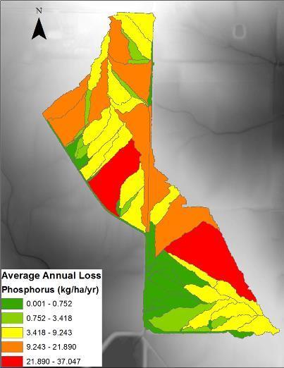
19 Results: Nutrients Only evaluated for total nitrogen and total phosphorus. Phosphorus estimation: R 2 = 0.74 and E = Nitrogen estimation: R 2 = 0.15 and E = Model can satisfactorily estimate phosphorus losses from agricultural watersheds in East Mississippi. Evaluation of total phosphorus (TP) loading estimation for AnnAGNPS in East MS. Model did not satisfactorily estimate nitrogen loadings. Evaluation of total nitrogen (TN) loading estimation for AnnAGNPS in East MS.
20 Results Evaluation of the OFWS system using AnnAGNPS OFWS system in East Mississippi: ac ft of water for irrigation 46 tons of sediment, 558 kg of TP captured

21 Results Evaluation of alternative management practice using AnnAGNPS Poultry and tillage in spring: 7.5% phosphorus loss reduction. All soybean acreage: 56.8% phosphorus loss increase. No change in runoff under different cropping practice.
22 General Conclusions AnnAGNPS can be successfully used to estimate runoff (R 2 = 0.85, E = 0.82), sediment (R 2 = 0.88, E = 0.67), and phosphorus loadings (R 2 = 0.74, E = 0.54) from watersheds in East Mississippi. AnnAGNPS can help evaluate potential sites for the establishment of OFWS systems: Estimate potential runoff that can be captured for irrigation. Estimate phosphorus and sediment that can captured to prevent downstream nutrient and sediment loading. OFWS systems can be effective in controlling downstream nutrient and sediment loading; AnnAGNPS predicted 46 tons of sediment and 558 kg of phosphorus were captured during the evaluated period.


23 Acknowledgements Farmers: Mr. Dale Weaver and Mr. Paul Good Dr. Dennis Reginelli Research team
24 Application of AnnAGNPS to model an agricultural watershed in East-Central Mississippi for the evaluation of an on-farm water storage (OFWS) system Ritesh Karki a, Mary Love M. Tagert a, Joel O. Paz a, Ronal L. Bingner b A Department of Agricultural and Biological Engineering, Mississippi State University, Mississippi State, MS USA B USDA ARS National Sedimentation Laboratory, 598 McElroy Drive, Oxford, MS USA Alabama Water Resources Conference & Symposium September 7, 2017