Early Warning System in Lao PDR
|
|
|
- Madison Houston
- 5 years ago
- Views:
Transcription
1 Early Warning System in Lao PDR By Virana Sonnasinh Planning Division Planning and Cooperation Division Ministry of Natural Resources and Environment
 165000 24000 202000 184000")

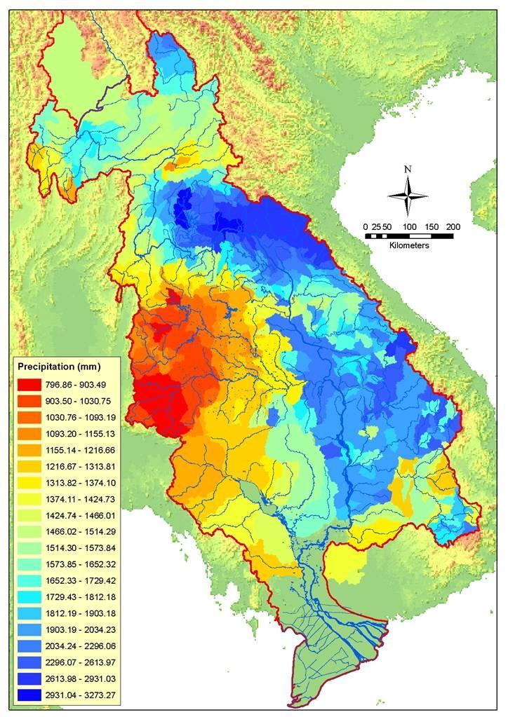
2 Country Background Description Country or provinces Yunan Mynmar Lao PDR Thailand Cambodia Viet Nam MRB Area (km2) Catment /country (percent) Population (million) MRB (percent
3 mean monthly runoff (m3/s) Country Background 45,000 40,000 35,000 30,000 25,000 20,000 15,000 10,000 5,000 0 Vietnam Cambodia Thailand Laos Myanmar China Jan Feb Mar Apr May Jun Jul Aug Sep Oct Nov Dec Area (km2) Average flow (m3/sec) from area Average flow (percent) Country or provinces YN MM LA TH CAM VN MRB ,

4 Country Bacground


5 Flooding in Vientiane Capital 1966


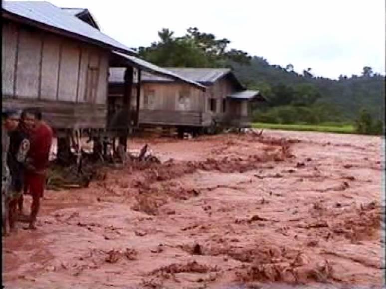
6 Flooding in Northern province of Luangnamtha in 2006
7 Institutional Arrangement for Disaster Management in Lao PDR National Disaster Management Committee 1 Minister of Labor and Social Welfare Chairman 2 Minister of Agriculture and Forestry Vice Chairman 3 Chief of Cabinet, Ministry of Foreign Affaires Vice Chairman 4 Chief of Cabinet, Ministry of Defense Member 5 Chief of Cabinet, Ministry of Security Member 6 Chief of Cabinet, Ministry of Education Member 7 Director General of Budget Department, Ministry of Finance Member 8 Director General of Transport Department, Ministry of Public Works and Transport Member 9 Director of Industry Department, Ministry of Industry and Commerce Member 10 Director of Hygiene Department, Ministry of Public Health Member 11 Director of Mass Media Department, Ministry of Information and Culture Member 12 Director of Social Welfare Department, Ministry of Labors and Social Welfare Member 13 Chairman of Lao Red Cross Society Member
8 Flood Forecasting, Warning, and Dissemination Department of Meteorology and Hydrology forecasting 17 main synoptic surface station 33 secondary synoptic stations 113 rain gauges. Staff gauges are 119 Staff gauges 49 discharge measurement stations C-Band Doppler radar at DMH Headquarter MTSAT 1R satellite receiving station Warning Dissemination
9 Flood Forecasting Flood Forecasting The preparation of daily flood bulletins is completed at 10:00 am. The product of flood forecasting lead time is 48 hours (from 7:00 am today to 7:00 am day after tomorrow) and update daily. The flood forecasting is mainly water levels and the forecasting includs only 6 stations ( Luangprabang, Vientiane, Paksane, Thakek, Savanakhet, and Pakse) HVT, forecast = (HLB, yesterday HLB, day before yesterday)* HVT, today Where: HVT = water level observes on 7:00 am (local time) at hydrological station Vientiane Km4 HLB = water level observes on 7:00 am (local time) at hydrological station Luangprabang
10 Flood Warning and Dissemination Nearly warning In the case the water level forecast at that station will expect to be at 0.50 m below warning level. DMH has to provide the warning and timely delivering to Mass media and Ministry of Agriculture and Forestry Prime Minister s Office, LNMC and NDMO DMH make an interview to mass media DMH sent the warning information to PAFO and PHM and to focus areas The warning message is broadcasted through national and local radio stations during daily programme for disaster management Urgent warning In the case the water level exceeds warning level. DMH has to provide the urgent warning to Mass media and DMH makes an interview to mass media DMH report to Ministry of Agriculture and Forestry and later report to Prime Minister Prime Minister s Office, and LNMC DMH sent the warning information to PAFO and PHM and to focus areas At the same time DMH sends urgent warning to NDMO NDMO sends the urgent warning to Provincial disaster management office and later to district office and focus areas National radio stations will broadcast the warning massage through its program regularly
11 Lessons learnt The flooding in Vientiane capital in 2008 is severe and exceed the historical highest record in 1966 The timely flood forecasting and dissemination provided by Department of Meteorology and Hydrology was helpful for making arrangements and preparing measures by each level of Government lines Agencies in Lao PDR. Lack of tool for flood victims evacuation such as boat, rescue team no means access to flooding areas. Improvements of data coverage are particularly needed over north of Luangprabang in Lao PDR in favor of accurate flood forecasting along the Mekong River. Awareness on utilize Meteorological / Hydrological information to users and disasters prevention to flood risk community need to be improved. The strong political commitment is very crucial for successful large scale flood preparedness The unplanned urban development and spontaneous settlements escalate the flood damages and losses no standard format for assessing flood damages results in the misuse of the resources

12