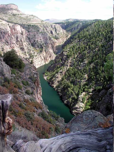
The Drainage Basin. From Peaks of Colorado to Mexico 1,400 miles Drains 242,000 square miles of Western US Colored River because of sediments
|
|
|
- Pamela Horn
- 5 years ago
- Views:
Transcription

1 HOOVER DAM

2 Need arose to control the Colorado River flow and the cycles of flood and drought. Responsibility fell on the Department of the Interior s Bureau of Reclamation Colorado River Compact History

3 The Drainage Basin From Peaks of Colorado to Mexico 1,400 miles Drains 242,000 square miles of Western US Colored River because of sediments


4 The Imperial Canal and the Salton 1896 California Development Company began building irrigation canals in the Imperial Valley Completed in 1901 During 1905 the canal s poor construction changed the course of the river into the Salton Sink during a series of flash floods Lasted for 16 months and filled the Salton Sink to become the Salton Sea Southern Pacific Railroad invested 3 Million dollars to force river back into its channel Sea

5 Controlling the River Attempts had been made without much success in the 1900s Several dams have been built along the Colorado River The majority of the river in normal hydrologic years is diverted for agricultural and municipal water supply. The large number of dams have caused environmental concern

6 Purpose of Controlling the Source of irrigation, drinking for most of the southwest. Allocation of the water is controlled by the Colorado River Compact Almost 90% of all water diverted from the river is for irrigation purposes Home to the largest manmade canal: the All- American Canal Colorado River

7 Reclamation and U.S. Geological Survey investigated 70 sites Two potential sites in lower basin: Boulder Canyon and Black Canyon Near Las Vegas In 1928 the Black Canyon was selected Site Selection

8 Boulder Canyon Black Canyon

9 Boulder Canyon Project Act 1928 Approved Colorado River Compact Authorized construction of a dam and All American Canal System Authorized $165 million for entire project

10 Site was selected based on temperatures and soil conditions Located 2000 ft above the river and 7 miles from Black Canyon Became part of Nevada in 1959 Highways and railroads were also built Electricity was brought in by a 222 mile long transmission line Boulder City

11 Purpose of the Project Flood Control Water Storage Silt Control Electricity

12 Six Companies A joint venture of six different companies won the contract Bid: $48.9 million dollars Largest construction contract let by federal government
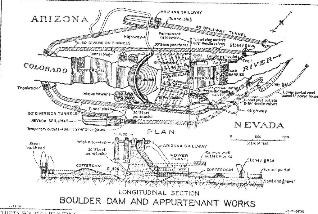
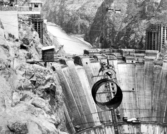
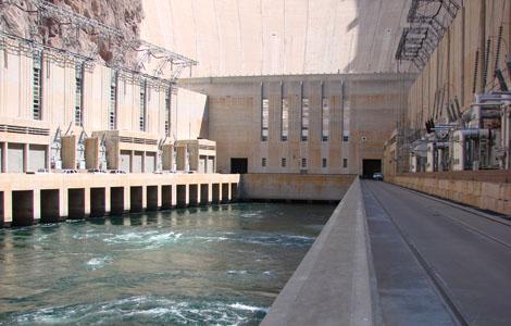
13 General Construction Plan Detouring the river Tunnels Cofferdams Stripping of rock and cutting of niches Excavation and cuts Cables Concrete and Structures Spillways Intake towers Penstock and outlet system Installation of plate steel pipes The Powerhouse
14
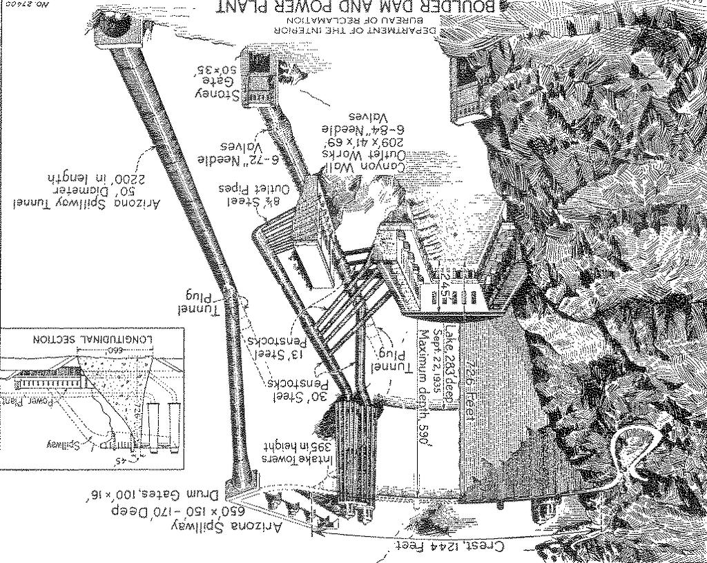
15

16 The Diversion of the River 4 diversion tunnels 2 on each side of the river Tunnels excavation began in June 1931 and finished in November 1933 Constructed by traditional drill and blast methods

17 2 cofferdams built to divert flow 1 located below tunnel inlet (Arizona side) 1 located across the river channel below the dam site but above the tunnel outlets In 1932 the River was successfully diverted into the concrete-lined diversion tunnels Cofferdams

18 Excavation and High Scaling Work went on 24/7 Excavated to 135 ft. Loose and projecting rocks removed by high scalers About 1 million cubic yards of rock were removed this way.

19 The Cement Cementing began in 1933 Cooling the concrete required an innovative design Built in series of 230 vertical columns Keyed the sides of the column to pass water through them These holes were then grouted
20

21 Penstocks and outlet systems Penstocks-very large pipes A plate steel fabricating plant built on the construction railroad


22 Spillway and intake towers
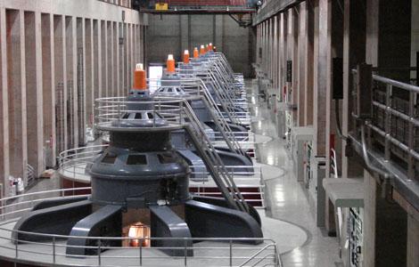
23 The Powerhouse and Generators

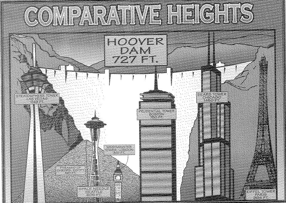
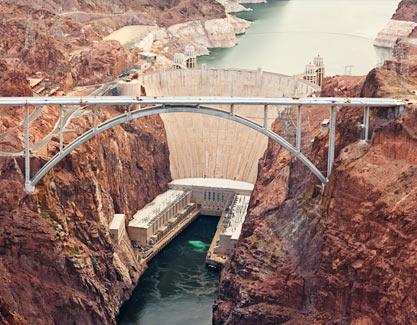
24 The Completed Dam Finished in 1936 Two years ahead of schedule Dam Towers are ft Base thickness 660ft Stretches a quarter mile
25

26 Provides year round water to Nevada, Arizona, California and Mexico 20 million people depend on the river Powerplant generates more than 4 billion kwh of electricity a year. Provides for 1.3 million people Power revenues have repaid original construction costs and pays for operation and maintenance needs Performance

27 Environmental Impacts Impact on downstream environment Interrupting Natural Cycles Armoring the Riverbed Removing Sediment Starving the River Changing Temperatures Stopping Fish Migration Erosion Refuges were built along the river by the U.S. Fish and Wildlife Service

28 The All-American Canal Completed in miles Diverts water to the Imperial Valley

29 Flood control Irrigation no longer disturbed by flash floods and droughts Drinking water Extensive reduction of the sediment that clogged canals and irrigation ditches Recreational area-lake Mead Fish and Wildlife Conservation Pollution-free low cost hydroelectric power Benefits
30