|
|
|
- Sarah Russell
- 5 years ago
- Views:
Transcription
1
2
3
4
5
6
7
8
9
10
11
12
13
14
15
16
17
18
19
20
21
22
23
24
25
26
27
28
29
30
31
32
33
34
35
36
37
38
39
40


41
42

43
44


45 Gabbs Airport June 2, 2009 Gabbs, Nevada Project No Photograph 1: View of site from eastern site boundary, facing west. Photograph 2: View of eastern adjoining undeveloped property, facing east from east end of runway A


46 Gabbs Airport June 2, 2009 Gabbs, Nevada Project No Photograph 3: View of site, facing west from eastern end of runway. Photograph 4: View of northern adjoining undeveloped property, facing north from northern boundary of site A


47 Gabbs Airport June 2, 2009 Gabbs, Nevada Project No Photograph 5: View of western adjoining undeveloped property, facing west from western end of runway. Photograph 6: View of southern adjoining undeveloped property, facing south from southern end of runway A


48 Gabbs Airport June 2, 2009 Gabbs, Nevada Project No Photograph 7: View of hanger on southeastern portion of site, facing north. Photograph 8: View of lube oil, gear oil, motor oil, and antifreeze containers inside hangar A


49 Gabbs Airport June 2, 2009 Gabbs, Nevada Project No Photograph 9: View of stained soil inside hangar. Photograph 10: View of empty 55-gallon drum, oil filter, and stained soil west of hangar A


50 Gabbs Airport June 2, 2009 Gabbs, Nevada Project No Photograph 11: View of abandoned water supply well and settling tank west of hangar, facing west. Photograph 12: View of beacon tower and associated electrical building on southeast portion of site, facing southwest A


51 Gabbs Airport June 2, 2009 Gabbs, Nevada Project No Photograph 13: View of pole-mounted transformer on southeast portion of site. Photograph 14: View of roadway sand on State Highway Department storage area on southeastern portion of site, facing east A


52 Gabbs Airport June 2, 2009 Gabbs, Nevada Project No Photograph 15: View of roadway sand on State Highway Department storage area on southeastern portion of site, facing east. Photograph 16: View of groundwater monitoring well on site A


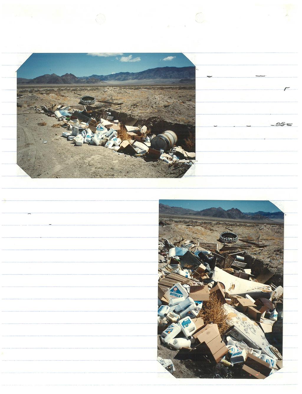
53 Gabbs Airport June 2, 2009 Gabbs, Nevada Project No Photograph 17: View of surface dump containing cans, bottles, and debris on southeast corner of site, facing southeast. Photograph 18: View of closed Gabbs Airport dump on southeast portion of site, facing northeast A
54
55
56
57
58
59
60
61
62
63
64
65
66

67
68
69
70
71
72
73 TM Environmental FirstSearch Report Target Property: Gabbs Airport GABBS NV Job Number: PREPARED FOR: Ninyo and Moore 6700 Paradise Road, Suite E Las Vegas, Nevada Tel: (866) Fax: (818) Environmental FirstSearch is a registered trademark of FirstSearch Technology Corporation. All rights reserved.
74 Environmental FirstSearch Search Summary Report Target Site: GABBS NV FirstSearch Summary Database Sel Updated Radius Site 1/8 1/4 1/2 1/2> ZIP TOTALS NPL Y NPL Delisted Y CERCLIS Y NFRAP Y RCRA COR ACT Y RCRA TSD Y RCRA GEN Y RCRA NLR Y Federal IC / EC Y ERNS Y Tribal Lands Y State/Tribal Sites Y State/Tribal SWL Y State/Tribal LUST Y State/Tribal UST/AST Y State/Tribal EC Y NA State/Tribal IC Y NA State/Tribal VCP Y NA State/Tribal Brownfields Y State Other Y TOTALS Notice of Disclaimer Due to the limitations, constraints, inaccuracies and incompleteness of government information and computer mapping data currently available to TRACK Info Services, certain conventions have been utilized in preparing the locations of all federal, state and local agency sites residing in TRACK Info Services's databases. All EPA NPL and state landfill sites are depicted by a rectangle approximating their location and size. The boundaries of the rectangles represent the eastern and western most longitudes; the northern and southern most latitudes. As such, the mapped areas may exceed the actual areas and do not represent the actual boundaries of these properties. All other sites are depicted by a point representing their approximate address location and make no attempt to represent the actual areas of the associated property. Actual boundaries and locations of individual properties can be found in the files residing at the agency responsible for such information. Waiver of Liability Although TRACK Info Services uses its best efforts to research the actual location of each site, TRACK Info Services does not and can not warrant the accuracy of these sites with regard to exact location and size. All authorized users of TRACK Info Services's services proceeding are signifying an understanding of TRACK Info Services's searching and mapping conventions, and agree to waive any and all liability claims associated with search and map results showing incomplete and or inaccurate site locations.
75 Environmental FirstSearch Site Information Report Request Date: Search Type: AREA Requestor Name: Mark Gray 2.08 sq mile(s) Standard: ASTM-05 Job Number: Filtered Report Target Site: GABBS NV Demographics Sites: 1 Non-Geocoded: 0 Population: NA Radon: PCI/L Site Location Degrees (Decimal) Degrees (Min/Sec) UTMs Longitude: :57:39 Easting: Latitude: :55:38 Northing: Zone: 11 Comment: Comment Additional Requests/Services Adjacent ZIP Codes: 0 Mile(s) Services: ZIP Code City Name ST Dist/Dir Sel Requested? Date Sanborns Aerial Photographs Historical Topos City Directories No No No No Title Search/Env Liens Yes Municipal Reports No Online Topos Yes
76 Environmental FirstSearch Selected Sites Summary Report Target Property: JOB: GABBS NV TOTAL: 1 GEOCODED: 1 NON GEOCODED: 0 SELECTED: 1 Page No. DB Type Site Name/ID/Status Address Dist/Dir Map ID 1 SWL GABBS AIRPORT DUMP NYE COUNTY PUBLIC WORKS, P /CLOSED GABBS NV
 or Hazardous Waste Tribal Land.")
77 Environmental FirstSearch Topo : 1.00 Mile Radius from Area Single Map, GABBS NV Source: Area Polygon... Identified Site, Multiple Sites, Receptor... NPL, DELNPL, Brownfield, Solid Waste Landfill (SWL) or Hazardous Waste Tribal Land... Map Name: DOWNEYVILLE Date Created: Date Revised: None-- Map Reference Code: H8-TF-024 COPYRIGHT: MAPTECH INC.
78 Environmental FirstSearch 1 Mile Radius from Area Single Map:, GABBS NV Source: U.S. Census TIGER Files Area Polygon... Identified Site, Multiple Sites, Receptor... NPL, DELNPL, Brownfield, Solid Waste Landfill (SWL), Hazardous Waste Triballand... Railroads...
79 Environmental FirstSearch 1 Mile Radius from Area ASTM-05: NPL, RCRACOR, STATE, GABBS NV Source: U.S. Census TIGER Files Area Polygon... Identified Site, Multiple Sites, Receptor... NPL, DELNPL, Brownfield, Solid Waste Landfill (SWL), Hazardous Waste Triballand... Railroads...
80 Environmental FirstSearch.5 Mile Radius from Area ASTM-05: Multiple Databases, GABBS NV Source: U.S. Census TIGER Files Area Polygon... Identified Site, Multiple Sites, Receptor... NPL, DELNPL, Brownfield, Solid Waste Landfill (SWL), Hazardous Waste Triballand... Railroads...
81 Environmental FirstSearch.25 Mile Radius from Area ASTM-05: RCRAGEN, UST, OTHER, GABBS NV Source: U.S. Census TIGER Files Area Polygon... Identified Site, Multiple Sites, Receptor... NPL, DELNPL, Brownfield, Solid Waste Landfill (SWL), Hazardous Waste Triballand... Railroads...
82 Environmental FirstSearch.12 Mile Radius from Area ASTM-05: ERNS, RCRANLR, GABBS NV Source: U.S. Census TIGER Files Area Polygon... Identified Site, Multiple Sites, Receptor... NPL, DELNPL, Brownfield, Solid Waste Landfill (SWL), Hazardous Waste Triballand... Railroads...
83 Site Details Page - 1
84 Environmental FirstSearch Site Detail Report Target Property: JOB: GABBS NV SWL SEARCH ID: 1 DIST/DIR: MAP ID: 1 NAME: GABBS AIRPORT DUMP REV: 06/27/02 ADDRESS: NYE COUNTY PUBLIC WORKS, P.O. BOX 887 ID1: 85 GABBS NV ID2: STATUS: CLOSED CONTACT: PHONE: Permitted Facility: No Class: II Status: Closed Owner Type: Private Contact: Gabbs Airport Operator: Rate In Tons Per Day: Date Closed (only provided if actually closed): 1/1/92 Population: Legal Description: T12N R36E Sec.8 Selected Site Details Page - 2
85 Environmental FirstSearch Descriptions NPL: EPA NATIONAL PRIORITY LIST - The National Priorities List is a list of the worst hazardous waste sites that have been identified by Superfund. Sites are only put on the list after they have been scored using the Hazard Ranking System (HRS), and have been subjected to public comment. Any site on the NPL is eligible for cleanup using Superfund Trust money. A Superfund site is any land in the United States that has been contaminated by hazardous waste and identified by the Environmental Protection Agency (EPA) as a candidate for cleanup because it poses a risk to human health and/or the environment. FINAL - Currently on the Final NPL PROPOSED - Proposed for NPL NPL DELISTED: EPA NATIONAL PRIORITY LIST Subset - Database of delisted NPL sites. The National Oil and Hazardous Substances Pollution Contingency Plan (NCP) establishes the criteria that the EPA uses to delete sites from the NPL. In accordance with 40 CFR (e), sites may be deleted from the NPL where no further response is appropriate. DELISTED - Deleted from the Final NPL CERCLIS: EPA COMPREHENSIVE ENVIRONMENTAL RESPONSE COMPENSATION AND LIABILITY INFORMATION SYSTEM (CERCLIS)- CERCLIS is a database of potential and confirmed hazardous waste sites at which the EPA Superfund program has some involvement. It contains sites that are either proposed to be or are on the National Priorities List (NPL) as well as sites that are in the screening and assessment phase for possible inclusion on the NPL. PART OF NPL- Site is part of NPL site DELETED - Deleted from the Final NPL FINAL - Currently on the Final NPL NOT PROPOSED - Not on the NPL NOT VALID - Not Valid Site or Incident PROPOSED - Proposed for NPL REMOVED - Removed from Proposed NPL SCAN PLAN - Pre-proposal Site WITHDRAWN - Withdrawn NFRAP: EPA COMPREHENSIVE ENVIRONMENTAL RESPONSE COMPENSATION AND LIABILITY INFORMATION SYSTEM ARCHIVED SITES - database of Archive designated CERCLA sites that, to the best of EPA's knowledge, assessment has been completed and has determined no further steps will be taken to list this site on the National Priorities List (NPL). This decision does not necessarily mean that there is no hazard associated with a given site; it only means that, based upon available information, the location is not judged to be a potential NPL site. NFRAP No Further Remedial Action Plan P - Site is part of NPL site D - Deleted from the Final NPL F - Currently on the Final NPL N - Not on the NPL O - Not Valid Site or Incident P - Proposed for NPL R - Removed from Proposed NPL S - Pre-proposal Site W Withdrawn RCRA COR ACT: EPA RESOURCE CONSERVATION AND RECOVERY INFORMATION SYSTEM SITES - Database of hazardous waste information contained in the Resource Conservation and Recovery Act Information (RCRAInfo), a national program management and inventory system about hazardous waste handlers. In general, all generators, transporters, treaters, storers, and disposers of hazardous waste are required to provide information about their activities to state environmental agencies. These agencies, in turn pass on the information to regional and national EPA offices. This regulation is governed by the Resource Conservation and Recovery Act (RCRA), as amended by the Hazardous and Solid Waste Amendments of RCRAInfo facilities that have reported violations and subject to corrective actions. RCRA TSD: EPA RESOURCE CONSERVATION AND RECOVERY INFORMATION SYSTEM
86 TREATMENT, STORAGE, and DISPOSAL FACILITIES. - Database of hazardous waste information contained in the Resource Conservation and Recovery Act Information (RCRAInfo), a national program management and inventory system about hazardous waste handlers. In general, all generators, transporters, treaters, storers, and disposers of hazardous waste are required to provide information about their activities to state environmental agencies. These agencies, in turn pass on the information to regional and national EPA offices. This regulation is governed by the Resource Conservation and Recovery Act (RCRA), as amended by the Hazardous and Solid Waste Amendments of Facilities that treat, store, dispose, or incinerate hazardous waste. RCRA GEN: EPA RESOURCE CONSERVATION AND RECOVERY INFORMATION SYSTEM GENERATORS - Database of hazardous waste information contained in the Resource Conservation and Recovery Act Information (RCRAInfo), a national program management and inventory system about hazardous waste handlers. In general, all generators, transporters, treaters, storers, and disposers of hazardous waste are required to provide information about their activities to state environmental agencies. These agencies, in turn pass on the information to regional and national EPA offices. This regulation is governed by the Resource Conservation and Recovery Act (RCRA), as amended by the Hazardous and Solid Waste Amendments of Facilities that generate or transport hazardous waste or meet other RCRA requirements. LGN - Large Quantity Generators SGN - Small Quantity Generators VGN Conditionally Exempt Generator. Included are RAATS (RCRA Administrative Action Tracking System) and CMEL (Compliance Monitoring & Enforcement List) facilities. RCRA NLR: EPA RESOURCE CONSERVATION AND RECOVERY INFORMATION SYSTEM SITES - Database of hazardous waste information contained in the Resource Conservation and Recovery Act Information (RCRAInfo), a national program management and inventory system about hazardous waste handlers. In general, all generators, transporters, treaters, storers, and disposers of hazardous waste are required to provide information about their activities to state environmental agencies. These agencies, in turn pass on the information to regional and national EPA offices. This regulation is governed by the Resource Conservation and Recovery Act (RCRA), as amended by the Hazardous and Solid Waste Amendments of Facilities not currently classified by the EPA but are still included in the RCRAInfo database. Reasons for non classification: Failure to report in a timely matter. No longer in business. No longer in business at the listed address. No longer generating hazardous waste materials in quantities which require reporting. Federal IC / EC: EPA BROWNFIELD MANAGEMENT SYSTEM (BMS) - database designed to assist EPA in collecting, tracking, and updating information, as well as reporting on the major activities and accomplishments of the various Brownfield grant Programs. FEDERAL ENGINEERING AND INSTITUTIONAL CONTROLS- Superfund sites that have either an engineering or an institutional control. The data includes the control and the media contaminated. ERNS: EPA/NRC EMERGENCY RESPONSE NOTIFICATION SYSTEM (ERNS) - Database of incidents reported to the National Response Center. These incidents include chemical spills, accidents involving chemicals (such as fires or explosions), oil spills, transportation accidents that involve oil or chemicals, releases of radioactive materials, sightings of oil sheens on bodies of water, terrorist incidents involving chemicals, incidents where illegally dumped chemicals have been found, and drills intended to prepare responders to handle these kinds of incidents. Data since January 2001 has been received from the National Response System database as the EPA no longer maintains this data. Tribal Lands: DOI/BIA INDIAN LANDS OF THE UNITED STATES - Database of areas with boundaries established by treaty, statute, and (or) executive or court order, recognized by the Federal Government as territory in which American Indian tribes have primary governmental authority. The Indian Lands of the United States map layer shows areas of 640 acres or more, administered by the Bureau of Indian Affairs. Included are Federally-administered lands within a reservation which may or may not be considered part of the reservation. State/Tribal Sites: NV DOC CORRECTIVE ACTION CASES- The Bureau of Corrective Actions maintains a list of clean-up evaluations and actions regarding sites with actual or potential contamination that could affect groundwater. This includes various types of sites including those regulated under Nevada State legislation described in detail in the Nevada State web site under legislation section NAC NAC
87 State/Tribal SWL: NV DOC SOLID WASTE LANDFILLS-This division maintains an inventory of various solid waste facilities including open, closed, & permitted landfills, dumps, pesticide sites, and transfer stations. The inventory notes landfill class type and if the site is a private or government facility. State/Tribal LUST: NV DOC LEAKING UNDERGROUND STORAGE TANKS- This division maintains an inventory of sites with leaking underground storagetanks. It includes sites with tanks under investigation for potentialleaks, confirmed leaks, and those to be closed. WASHOE COUNTY LEAKING UNDERGROUND STORAGE TANKS- This department maintains a list of sites with leaking underground storagetanks. It includes sites with tanks under investigation for potentialleaks, confirmed leaks, and those to be closed or needing emergency action. State/Tribal UST/AST: NV DOC/EPA 9 UNDERGROUND STORAGE TANKS- This division maintains an inventory of underground storage tanks. INDIAN LANDS UST LIST-A listing of underground storage tanks currently on Indian lands under federal jurisdiction. Nevada Indian Lands USTs are administered by US EPA Region 9. ABOVE GROUND STORAGE TANKS- This division maintains an inventory of sites with above ground storage tanks. For more information regarding specific sites, please call the number listed above. Please Note: AST sites are listed within the UST area of the First Search reports. They can be identified as AST sites by the site ID number. The site ID number islocated in the Site Summary or Site Details section of the report. The site ID notes "AST" before the agency id. State/Tribal Brownfields: NV DOC/EPA BROWNFIELDS SITES- The Bureau of Corrective Actions maintains a list of brownfield sites as part of its listing of clean-up evaluations and actions regarding sites with actual or potential contamination that could affect groundwater. The NDEP defines a brownfield as an abandoned, idled, or underused industrial or commercial properties taken out of productive use because of real or perceived risks from environmental contamination. Brownfields Management System (BMS) is an analytical database designed to assist EPA in collecting, tracking, and updating information, as well as reporting on the major activities and accomplishments of the various Brownfield grant Programs. RADON: NTIS NATIONAL RADON DATABASE - EPA radon data from national radon project collected for a variety of zip codes across the United States. State Other: US DOJ NATIONAL CLANDESTINE LABORATORY REGISTER - Database of addresses of some locations where law enforcement agencies reported they found chemicals or other items that indicated the presence of either clandestine drug laboratories or dumpsites. In most cases, the source of the entries is not the U.S. Department of Justice ("the Department"), and the Department has not verified the entry and does not guarantee its accuracy. All sites that are included in this data set will have an id that starts with NCLR.
88 Environmental FirstSearch Database Sources NPL: EPA Environmental Protection Agency Updated quarterly NPL DELISTED: EPA Environmental Protection Agency Updated quarterly CERCLIS: EPA Environmental Protection Agency Updated quarterly NFRAP: EPA Environmental Protection Agency. Updated quarterly RCRA COR ACT: EPA Environmental Protection Agency. Updated quarterly RCRA TSD: EPA Environmental Protection Agency. Updated quarterly RCRA GEN: EPA Environmental Protection Agency. Updated quarterly RCRA NLR: EPA Environmental Protection Agency Updated quarterly Federal IC / EC: EPA Environmental Protection Agency Updated quarterly ERNS: EPA/NRC Environmental Protection Agency Updated semi-annually Tribal Lands: DOI/BIA United States Department of the Interior Updated annually State/Tribal Sites: NV DOC The Nevada Department of Conservation and Natural Resources,Division of
89 Environmental Protection (NDEP), Bureau of CorrectiveActions Updated quarterly/when available State/Tribal SWL: NV DOC The Nevada Department of Conservation and Natural Resources, Division of Environmental Protection (NDEP), Bureau of Corrective Actions Updated annually/when available State/Tribal LUST: NV DOC The Nevada Department of Conservation and Natural Resources,Division of Environmental Protection (NDEP), Bureau of CorrectiveActions Phone: (775) Washoe County Department of Environmental Health Updated quarterly/when available State/Tribal UST/AST: NV DOC/EPA 9 The Nevada Department of Conservation and Natural Resources, Division of Environmental Protection (NDEP), Bureau of Corrective Actions Phone: (775) US EPA Region 9, Underground Storage Tank Program Updated quarterly/when available State/Tribal Brownfields: NV DOC/EPA The Nevada Department of Conservation and Natural Resources, Division of Environmental Protection (NDEP), Bureau of Corrective Actions Phone: (775) Updated when available RADON: NTIS Environmental Protection Agency, National Technical Information Services Updated periodically State Other: US DOJ U.S. Department of Justice Updated when available
90
91
92
93
94
95
96


97


98
99
100
101
102


103


104
105

106
107
108
109
110
111
112
113
114
115
116

117

118