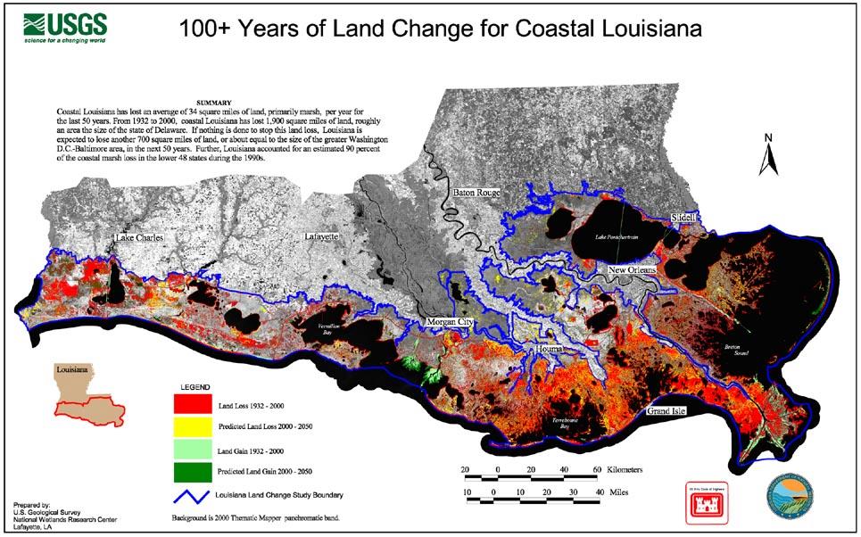
Coastal Restoration in Louisiana
|
|
|
- Randell Wells
- 5 years ago
- Views:
Transcription

1 Coastal Restoration in Louisiana
2 Presentation Topics Wetland Loss & the Importance of Coastal Louisiana The Coastal Restoration Effort The Louisiana Coastal Area Plan Development Components Status How can you help?
3 Mississippi River Drainage Basin Basin Facts Drains 41% of continental U.S. Includes 31 states & 2 Canadian provinces Total area drained 1.2 million square miles

4 Deltas of the Mississippi
5 Rise and Fall of Coastal Louisiana Land Built by Mississippi River (sq. miles) Written Language Pyramids Rome Founded Dark Ages Begin Renaissance Industrial Revolution Years Before / After Present

6


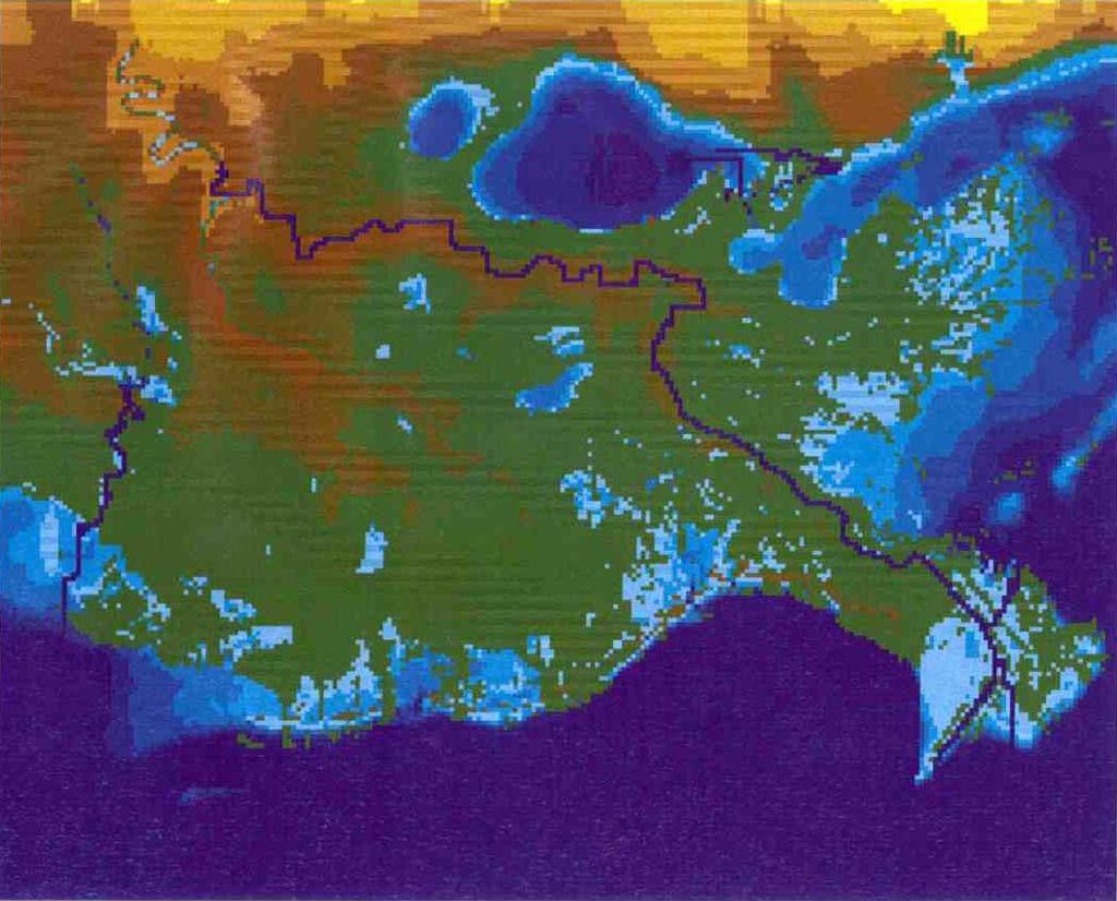
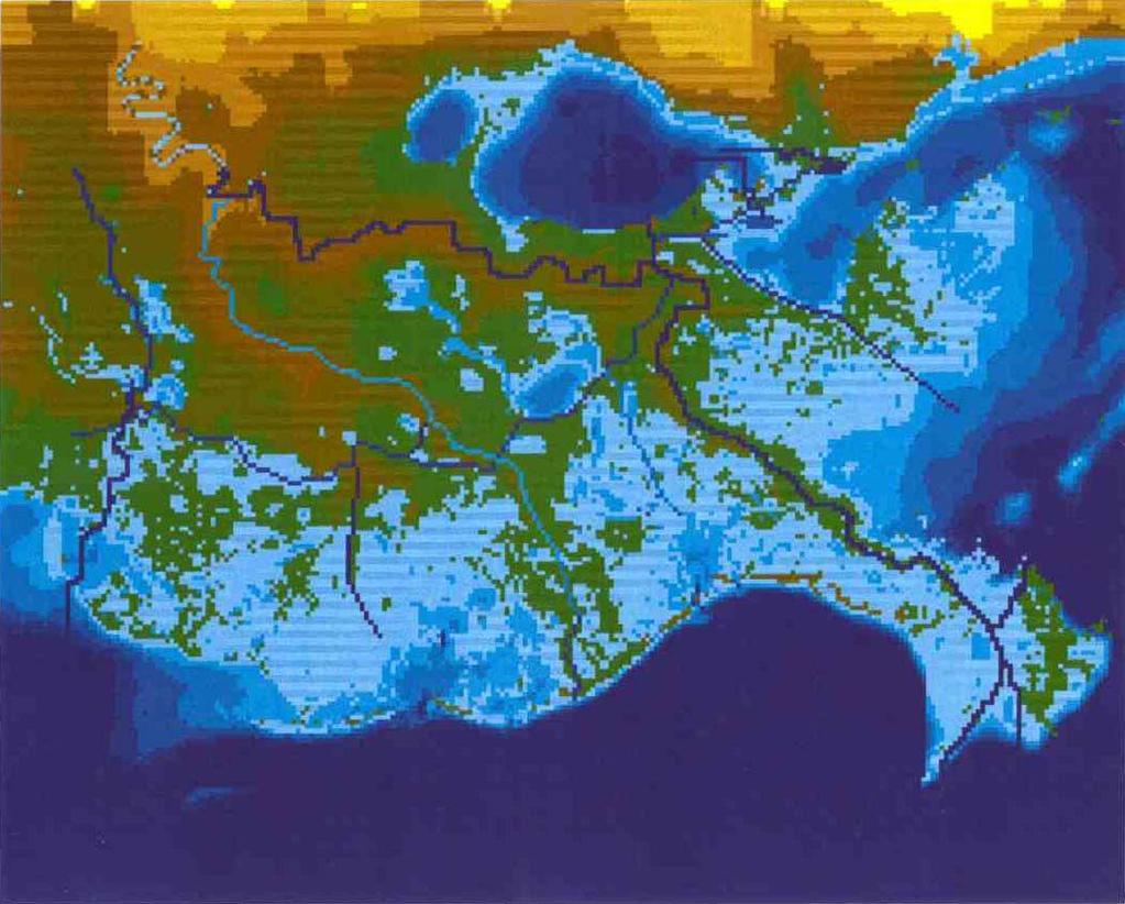
7 Past and Projected Wetland Loss in the Barataria-Terrebonne Basin (1839 to 2020)
8


9 Importance of Coastal Louisiana to the Nation Production & distribution infrastructure supplies U.S. with 27% of its oil and over 26% of its natural gas Ports rank 1 st in Nation by tonnage Coastal wetlands reduce storm damage costs Home to 70% of Mississippi River Valley s migratory waterfowl Home to 35% of U.S. commercial fisheries
10 Coastal Restoration Efforts in Louisiana 1986 WRDA provides initial CAP Authority 1990 Coastal Wetland Planning, Protection and Restoration Act (Breaux Act) Authorized 1993 Breaux Act Restoration Plan 1998 Coast 2050: Toward a Sustainable Coastal Louisiana 2000 Initiation of Louisiana Coastal Area Study 2005 Louisiana Coastal Area Study completed with a signed USACE Chief s Report
11 What is CAP? CAP stands for Continuing Authorities Program This program is designed for smaller projects Allows the Corps to respond more quickly than is possible through the specific Congressional authorization process Programs address specific types of projects, each with its own project authority and strict limit of the Federal contribution.
12 The 9 CAP Authorities Are: SECTION 205 (Small Flood Control) SECTION 14 (Emergency Streambank) SECTION 208 (Clearing & Snagging) SECTION 107 (Small Navigation) SECTION 103 (Beach Erosion) SECTION 111 (Mitigation of Shore Damages) SECTION 1135 (Ecosystem Restoration) SECTION 204 (Beneficial Use of Dredged Mat) SECTION 206 (Ecosystem Restoration)
13


14 CWPPRA Agencies USACE: Department of Army - U.S. Army Corps of Engineers NRCS: Department of Agriculture - Natural Resources Conservation Service NMFS: Department of Commerce - National Marine Fisheries Service USFWS: Department of the Interior - U.S. Fish and Wildlife Service USEPA: Environmental Protection Agency State of Louisiana - Office of the Governor


15 Breaux Act Process Planning/Outreach (Phase 0) PPL process Feasibility/P&S (Phase I) Construction (Phase II) Monitoring O & M
 Total cost of all projects PPLs 1-13 and planning is $1.700B, 30 year funding is estimated at $2.")
16 Status of Breaux Act 127 active projects on 13 Priority Project Lists (PPLs): 63 projects completed 12 projects under construction 23 scheduled for construction in FY05 29 scheduled for construction in FY06 and later Projects restore, create, or protect 116,751 acres of coastal wetlands (PPL 1-13) Total cost of all projects PPLs 1-13 and planning is $1.700B, 30 year funding is estimated at $2.0B Projects list can be found at

17 Opportunistic Use of the Bonnet Carre Spillway Divert 4,000 cfs of water and sediment from Mississippi River Project Area: 13,583 acres Increase nutrients, and sediment in Lake Pontchartrain, and surrounding marshes, especially LaBranche Decrease salinities

18 River Reintroduction into Maurepas Swamp (Hope Canal) Divert 2,000 cfs of water and sediment from Mississippi River Project Area: 36,121 acres Restore natural swamp hydrology Increase nutrients, sediment, accretion, and vegetation Decrease salinities
19 Programs to Address Coastal Wetland Loss Louisiana Coastal Area (72%) Continuing Authorities Program (2.5%) Freshwater Diversions (9%) Breaux Act Restoration Projects (14%) Other Programs (<1%) Navigation Maintenance Beneficial Use (1.5%) Breaux Act Conservation Plan (1%) Total Current Annual Wetland Loss: approximately 16,000 acres* *Based on 1990 to 2000 land loss data

20 Coast 2050 Vision sustain a coastal ecosystem that supports and protects the environment, economy and culture of southern Louisiana contributes greatly to the economy and well-being of the nation.

21 Coastwide Strategies for Wetland Restoration
22 Louisiana Coastal Area (LCA) Ecosystem Restoration Study

23 Study Objectives Ecosystem Objectives Sustain productive and diverse fish and wildlife habitats Reduce nutrient delivery to the continental shelf Hydrogeomorphic Objectives Establish dynamic salinity gradients Increase sediment input Maintain or establish natural landscape features and hydrologic processes
24 La. Coastal Area Plan Components Near-term Critical Restoration Features for Conditional Authorization Other Near-term Critical Restoration Features Recommended for Study and Future Congressional Authorization. 3. Science and Technology (S&T) Program. 4. Science and Technology Program Demonstration Projects. 5. Programmatic Authorization for the Beneficial-Use of Dredged Material Program. 6. Programmatic Authorization for Investigations of Modifications to t Existing Structures. 7. Large-scale and Long-term Concepts Requiring Detailed Studies.
25 La. Coastal Area Plan Components Near-term Critical Restoration Features for Conditional Authorization Other Near-term Critical Restoration Features Recommended for Study and Future Congressional Authorization. 3. Science and Technology (S&T) Program. 4. Science and Technology Program Demonstration Projects. 5. Programmatic Authorization for the Beneficial-Use of Dredged Material Program. 6. Programmatic Authorization for Investigations of Modifications to t Existing Structures. 7. Large-scale and Long-term Concepts Requiring Detailed Studies.
26 Near-term Critical Restoration Features 5 - Recommended for Conditional Authorization MRGO Environmental Restoration Features Small Diversion at Hope Canal Diversion Barataria Barrier Shoreline Restoration, Caminada Headland, Shell Island Small Bayou Lafourche Reintroduction Medium Diversion with Dedicated Dredging at Myrtle Grove 10 - Recommended for Approval with Future Authorization Multi-purpose Operation of Houma Navigation Canal Lock Terrebonne Basin Barrier Shoreline Restoration Maintain Land bridge between Caillou Lake and Gulf of Mexico Small Diversion at Convent / Blind River Increase Amite River Diversion Canal Influence by Gapping Banks Medium Diversion at White s Ditch Stabilize Gulf Shoreline at Pointe Au Fer Island Convey Atchafalaya River to Northern Terrebonne Marshes Modification of Caernarvon Diversion Modification of Davis Pond Diversion

27
28 La. Coastal Area Plan Components Near-term Critical Restoration Features for Conditional Authorization Other Near-term Critical Restoration Features Recommended for Study and Future Congressional Authorization. 3. Science and Technology (S&T) Program. 4. Science and Technology Program Demonstration Projects. 5. Programmatic Authorization for the Beneficial-Use of Dredged Material Program. 6. Programmatic Authorization for Investigations of Modifications to t Existing Structures. 7. Large-scale and Long-term Concepts Requiring Detailed Studies.
29 Science and Technology Program Primary components of the Science & Technology Program are: Science information needs Data acquisition and monitoring Data and information management Modeling and adaptive management Research Cost not to exceed $100,000,000 over ten years
30 La. Coastal Area Plan Components Near-term Critical Restoration Features for Conditional Authorization Other Near-term Critical Restoration Features Recommended for Study and Future Congressional Authorization. 3. Science and Technology (S&T) Program. 4. Science and Technology Program Demonstration Projects. 5. Programmatic Authorization for the Beneficial-Use of Dredged Material Program. 6. Programmatic Authorization for Investigations of Modifications to t Existing Structures. 7. Large-scale and Long-term Concepts Requiring Detailed Studies.
31 Demonstration Projects Developed by Science &Technology Program $100,000,000 construction limit $25,000,000 per project limit Initially identified candidate demonstration projects: Marsh restoration/creation Land bridge restoration Pipeline canal restoration Shoreline erosion prevention Barrier island restoration
32 La. Coastal Area Plan Components Near-term Critical Restoration Features for Conditional Authorization Other Near-term Critical Restoration Features Recommended for Study and Future Congressional Authorization. 3. Science and Technology (S&T) Program. 4. Science and Technology Program Demonstration Projects. 5. Programmatic Authorization for the Beneficial-Use of Dredged Material Program. 6. Programmatic Authorization for Investigations of Modifications to t Existing Structures. 7. Large-scale and Long-term Concepts Requiring Detailed Studies.
33 Beneficial Use of Dredged Material Due to funding constraints, O&M beneficial use program utilizes a portion of dredge material beneficially This leaves the potential for additional Beneficial Use projects Primary beneficial use areas are: - MRGO - bar channel - Barataria Bay Waterway - bay reach - Lower MR&T project, Head of Passes and Southwest Pass - Atchafalaya River - bar channel and bayous Chene, Boeuf & Black - Calcasieu River - inland reach and pass
34 La. Coastal Area Plan Components Near-term Critical Restoration Features for Conditional Authorization Other Near-term Critical Restoration Features Recommended for Study and Future Congressional Authorization. 3. Science and Technology (S&T) Program. 4. Science and Technology Program Demonstration Projects. 5. Programmatic Authorization for the Beneficial-Use of Dredged Material Program. 6. Programmatic Authorization for Investigations of Modifications to t Existing Structures. 7. Large-scale and Long-term Concepts Requiring Detailed Studies.
35 La. Coastal Area Plan Components Near-term Critical Restoration Features for Conditional Authorization Other Near-term Critical Restoration Features Recommended for Study and Future Congressional Authorization. 3. Science and Technology (S&T) Program. 4. Science and Technology Program Demonstration Projects. 5. Programmatic Authorization for the Beneficial-Use of Dredged Material Program. 6. Programmatic Authorization for Investigations of Modifications to t Existing Structures. 7. Large-scale and Long-term Concepts Requiring Detailed Studies.
36 Large Scale and Long-Term Concepts for Detailed Study 1. Mississippi River Delta Management Study 2. Third Delta Study 3. Upper Atchafalaya Basin Study (including operation of Old River Control Structure) 4. Chenier Plain Freshwater Management and Allocation Reassessment Study 5. Acadiana Bay Estuarine Restoration Study Continued Development of Large-Scale Long-Term Coastal Restoration Opportunities
37 LCA Cost Table Conditionally Authorized Near-term Features $828,300,000 Science & Technology Program $100,000,000 Demonstration Projects Program $ 95,000,000 Beneficial Use Dredge Material Program $100,000,000 Investigation of Modifications to Existing Structures $10,000,000 Total Conditionally Authorized Components $1,123,300,000 Near-term Feature Decision Documents $70,000,000 Large-scale, Long-term Studies $60,000,000 Investigations of Modification to Existing Structures $10,000,000 Demonstration Project Decision Documents $5,000,000 Total Currently Authorized Investigations $145,000,000 Total Congressionally Authorized Components $728,200,000 Total LCA Ecosystem Restoration $1,996,500,000
38 How can you help? Stay informed Participate in public meetings Write your Congressional representative Plans require authority to become reality Sending the message to the nation It is a National Issue Be prepared to be affected (Yes, in your back yard)
 862-2587 2587 julie.t..t.morgan@mvn02.usace.army.mil")
39 Questions? lacoast.gov For more information, please contact: Julie T. Morgan Outreach Program Specialist (504)