Integrated Monitoring Initiative for SDG 6
|
|
|
- Annabella Bradley
- 5 years ago
- Views:
Transcription
1 Water and sanitation in the 2030 Agenda Integrated Monitoring Initiative for SDG 6 1
2 Water and sanitation at the core of sustainable development Integrated management across sectors and regions balancing competing needs Industry Food Energy Climate change Scarcity Flooding Pollution Recycling Reuse Ecosystems - Resilience Risks related to famine, epidemics, migration, inequalities, political instability Human health and well-being

3 SDG 6 Ensure availability and sustainable management of water and sanitation for all 6.3 Wastewater and water quality 6.4 Water use and scarcity 6.2 Sanitation and hygiene 6.aand 6.b Cooperation and participation 6.1 Drinking water 6.5 Integrated resources management 6.6 Waterrelated ecosystems
4 No SDG 6 global indicators SDG 6 global indicators Safely managed drinking water services Safely managed sanitation services Wastewater safely treated* Good ambient water quality* Water use efficiency* Level of water stress Integrated water resources management Transboundary basin area with an operational arrangement for water cooperation* Water-related ecosystems* 6.a.1 Water-and sanitation-related official development assistance that is part of a government coordinated spending plan 6.b.1 Participation of local communities in water and sanitation management 4

5 Principle: Integrated data Ensure coherent policies and planning, informed decision-making integrated management Assess and analyse the potential consequences of different development paths Information often collected by different ministeries/institutions/ municipalities/utilities, national statistical office Need to integrate hydrological, environmental, social and economic information for an overall picture 5
, International Recommendations for Water Statistics (IRWS) 6")
6 Principle: Harmonisation Building on existing initiatives and efforts6 6 and in the same time ensuring comparable results, across countries and over time Internationally agreed definitions and standards, transparency E.g. System of Environmental- Economic Accounts for Water (SEEA-Water), International Recommendations for Water Statistics (IRWS) 6

7 Principle: Progressive monitoring Flexible methodologies for Member States to enter monitoring in line with national capacity and resource availability start simple and advance progressively as capacity and resources increase Opportunities for combining various methods and data sources direct measurements, surveys, remote sensing, estimates and literature reviews short term: estimates and modelling to fill data gaps long term: national monitoring to feed directly into global

8 Principle: Data disaggregation No goal or targetmet untilmet by all --leavingno one behind Data disaggregated by income, gender, age, race, ethnicity, migratory status, disability, geographic location and other characteristics relevant in national contexts 6.1 and 6.2 universal access work through survey instruments 6.3 to 6.6 impacts of poor resources management affect different groups differently work with data georeferencing 8
9 SDG 6 Integrated Monitoring: Global objectives Integrate and expand existing monitoring efforts, to ensure harmonised monitoring of the entire water cycle E.g. GEMStat, AQUASTAT, Status reporting on IWRM Engage Member States and enhance their capacity in water sector monitoring Provide Member States with a monitoring guide for SDG targets Report on global progress towards SDG targets
10 Monitoring water and sanitationin the 6.6 Ecosystems 6.5 Water management 6.1 Drinking water Goal Water use and scarcity 2030 Agenda JMP 6.2 Sanitation and hygiene 6.3 Wastewater and water quality (WHO/UNICEF Joint Monitoring Programme) GEMI GLAAS 6.a International cooperation and capacity development 6.b Stakeholder participation UN-Water (Global Analysis and Assessment of Sanitation and Drinking Water)
11 GEMI processand timeline Entry phase: investigating and identifying best-bet options for monitoring water and sanitation related issues Trial of best-bet in pilot countries Evaluation and revision Expert review Implementation / data collection (global roll-out) Baseline report(s)
12 Pilot testing 2016 Pilot testing of draft methodologies in a small number of countries selection based on interest and region Africa: Senegal and Uganda Asia: Bangladesh Europe/North America: Netherlands Latin America: Peru Middle East: Jordan Small Islands: Fiji (TBC)
13 SDG 6 Monitoring Team GEMI Coordination Team Lead: UN-Water Technical Advisory Unit Targets Team Lead: WHO, UNICEF (JMP) Target Team 6.3 Lead: WHO, UN-Habitat UNEP Target Team 6.4 Lead: FAO Target Team 6.5 Lead: UNEP UNESCO UNECE Target Team 6.6 Lead: UNEP Targets Team 6.a-6.b Lead: WHO (through GLAAS), supported by Target Team 6.5 OECD National Focal Points and Inter-Sectoral Monitoring Teams 13
14 Purpose of pilot testing To test technical feasibility of the methodologies To test institutional setup / process to implement the methodologies To gather lessons learned and recommendations for improving methodologies and implementing them at the global level in 2017 To define a country roadmap for establishing a baseline by
15 Outcomes of pilot testing Country-level outcomes (envisaged October 2016) Inception workshop Implementation of methodologies at a scale sufficient to test both technical and institutional feasibility Documented country feedback on feasibility Country roadmap for baseline data in Closing workshop Global-level outcomes (December 2016) Revised methodologies based on country feedback 15
16 Learning framework Overall process followed for implementing the indicator Institutional arrangements made for implementation and coordination across agencies Capacity required--specific skills and other resources used for implementation, as well as cost incurred Specific feedback on the methodology and on the clarity and usefulness of the step-by-step guide Feedback on data quality, management and analysis Feedback on the (likely) usefulness of the data for policy at national and subnational levels Links to existing measurement processes and the measurement of other indicators 16


17 Target 6.3 Water quality and wastewater By 2030, improve water quality by reducing pollution, eliminating dumping and minimizing release of hazardous chemicals and materials, halving the proportion of untreated wastewater and substantially increasing recycling and safe reuse globally Proportion of wastewater safely treated Proportion of bodies of water with good ambient water quality
18 6.3.1 Proportion of wastewater safely treated Indicator Definition Definition Proportion of wastewater generated by households (sewage + faecal sludge) that is safely treated Proportion of wastewater generated by economic activities (ISIC categories) that is safely treated Further explanations Moving from improved sanitation (MDG) to safely managed sanitation (SDG) Inclusion of onsite facilities is critical from a public health, environment and equity perspective approximately two thirds of world population use on-site facilities Focus on hazardous waste industries Diffuse pollution, e.g. runoff from agriculture, not included but indirectly captured by indicator Disaggregation Treatment level (primary/secondary/tertiary) Source (household/economic activity) Recipient (freshwater/sea/soil) Interlinkages Data from directly used to calculate indicator on sanitation Additional indicators on recycling and reuse needed to fully capture the ambition of the target, with links to indicators and


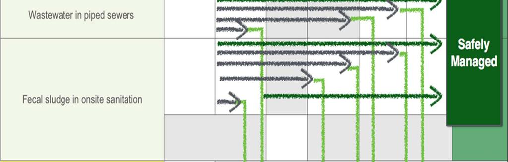
19 6.3 -Safely treated wastewater Generation Pretreatment/On site treatment Transport Treatment at Centralised WWTP Disposal/Reuse Households PART A Economic activities Hazardous Non-Hazardous PART B. Sewer Municipal WWTP
20 6.3 -Safely treated wastewater Indicator 6.3.1: % Safely treated wastewater Definition: PART A (Households): The fraction of wastewater carried through a sewer network to a designated location and treated at a treatment plant to an agreed level; or PART B (Economic activities): The proportion of hazardous wastewater pre-treated at source before discharge to a sewer or the environment.


21 Part A: Households
 Projected to 2015 with JMP disaggregated")
 Unimproved services (USS) No sanitation")
22 Part A: Households 100% 80% 30% 60% 74% 40% 44% 20% 0% 9% 9% 11% 11% 6% 6% JMP 2015 (MDGs) Projected to 2015 with JMP disaggregated data (SDGs) Safely managed services (SMSS) Basic services (BSS) Shared services (SHS) Unimproved services (USS) No sanitation services (NSS)
23 6.3 -Safely treated wastewater (definition) Indicator 6.3.1: % Safely treated wastewater Definition: PART A (Households): The fraction of wastewater carried through a sewer network to a designated location and treated at a treatment plant to an agreed level; or PART B (Economic activities): The proportion of hazardous wastewater pre-treated at source before discharge to a sewer or the environment.
24 Part B: Economic activities Methodology Data required Industry type/water use Size of Industry/ef fluent generated Discharge to: Hazardous/ Nonhazardous Discharge Compliance * All establishments By effluent flow, water consumption, or employees Sewer/ environment ISIC, Red List or local EPA permit Yes / No Hazardous effluent complying* Hazardous effluent generated = % of Hazardous wastewater safely treated % WW treatment = Domestic flow TOTAL flow x % treated (municipal WWTP) + Industrial flow TOTAL flow x % treated (industrial)
25 Indicator Steps of progressive monitoring 1 st step of progressive monitoring (example) Estimation of total wastewater generation by households from household surveys and population records. Estimation of total wastewater generation by economic activities from industry inventories, focusing on a few economic activities. Estimation of proportion wastewater received and treated from institutional/utility records. 2 nd step of progressive monitoring (example) Inclusion of questions on disposal/transportation in household survey instruments. Household estimations backed up with field surveys and data from licensed emptying service providers. Economic activities estimations backed up with institutional/utility records on agreed volumes; focus expanded to include more economic activities. Improved spatial and temporal resolution of institutional/utility data. Inclusion of information about treatment levels. 3 rd step of progressive monitoring (example) Inclusion of information about treatment compliance and reuse, as well as operation and maintenance aspects. High spatial and temporal resolution of institutional/utility data (metered volumes). Data can be fully disaggregated by treatment level (primary/secondary/tertiary), source (household/economic activity) and recipient (freshwater/sea/soil) 25

26 6.3.1 Proportion of wastewater safely treated National sources: Institutional/utility records, household surveys, on-site service providers, registers over economic activities Indicator Data sources Global databases: FAO s AQUASTAT, IBNET, WHO/UNICEF JMP, UNSD/UNEP Water Questionnaire for non OECD/Eurostat countries, OECD/Eurostat Questionnaire for OECD countries, UNIDO Statistics Data Portal Global compilation: WHO/UN-Habitat on behalf of UN-Water 26
27 6.3.1 alignmentwithseea Have incorporatedmostseeaw definitions, but some cases gone beyond faecal sludge Wastewater disaggregation by economic activity(isic) Needto improvealignmentbetween6.3.1 and


28 Target 6.4 Water use and scarcity By 2030, substantially increase water-use efficiency across all sectors and ensure sustainable withdrawals and supply of freshwater to address water scarcity and substantially reduce the number of people suffering from water scarcity Change in water use efficiency over time Level of water stress: freshwater withdrawal as a proportion of available Integrated freshwater Monitoring resources of SDG 6
29 Indicator Definition Proportion Change in water use efficiency over time Definition Water Output from a given economic activity (based on ISIC categories), per volume of net water withdrawn by the economic activity. The indicator includes water use by all economic activities, focusing on agriculture (excluding the portion generated by rainfedagriculture); manufacturing; electricity; and water collection, treatment and supply (looking at distribution efficiency, capturing network leakages). By looking at changes over time, the sectoral values can be aggregated into one. Further explanations The indicator informs on the economic component of the target ( increase water-use efficiency across all sectors ), highlighting sectors where water use efficiency is lagging behind. Disaggregation Regional differences in climate and water availability must be considered in the interpretation of the indicator, in particular in relation to agriculture. Interlinkages The indicator is multipurpose and can be used to report on targets 2.4, 8.4, 9.4, 12.2 and
30 Change in water use efficiency Definition This indicator is definedas the value added divided by the volume of water withdrawn over a period of time for a given major sector Following International Standard Industrial Classification of All Economic Activities(ISIC 4) coding, the major sectors are defined as: Agriculture, forestry and fishing (ISIC A [1-3]) Manufacturing; constructions; mining and quarrying; electricity, gas, steam and air conditioning supply (ISIC B [5-9], C [10-33], D [35] and F [41-43]) The service sectors (ISIC E [36-39] and G to U [45-99]), including: o water collection, treatment and supply industry (ISIC E [36])
31 Method of computation The indicator is computed as the sum of the three sectors listed above. In formula: = + + Where WE = Water efficiency A we = Irrigated agriculture water efficiency [USD/m 3 ] I we = Industrial water efficiency [USD/m 3 ] S we = Services water efficiency [USD/m 3 ]
32 Method of computation Water use efficiency in irrigated agriculture is calculated as the agricultural value added per agricultural water withdrawn, expressed in USD/m 3 : = (1 ) Where: A we = Irrigated agriculture water efficiency [USD/m 3 ] GVA a = Gross value added by agriculture (excluding river and marine fisheries and forestry) [USD] C r = Proportion of agricultural GVA produced by rainfed agriculture [-] V a = Volume of water withdrawn by the agricultural sector (including irrigation, livestock and aquaculture) [m 3 ]
33 Method of computation Water use efficiency of industries (including power production) is calculated as the industrial value added per unit of industrial water withdrawn, and expressed in USD/m 3 : = Where: I we = Industrial water efficiency [USD/m 3 ] GVA i = Gross value added by industry (including energy) [USD] V i = Volume of water withdrawn by the industries (including energy) [m 3 ]
34 Method of computation Services water supply efficiency is calculated as the service sector value added (ISIC and ISIC 45-99) divided by water withdrawn for distribution by the water collection, treatment and supply industry (ISIC 36), expressed in USD/m 3 : = Where: S we = Services water efficiency [USD/m 3 ] GVA s = Gross value added by services [USD] V s = Volume of water withdrawn by the service sector [m 3 ]
35 Supplementary indicators Energy (power) water use efficiency is calculated as the value added of power production per unit of water withdrawn for energy production, and expressed in MWh/m 3 : = Where: E we = Energy water efficiency [MWh/m 3 ] TEP = Total energy production [MWh] V e = Volume of water withdrawn for energy production, i.e. for the cooling of power plants (including evaporation from reservoirs created behind dams for hydropower) [m 3 ]
36 Supplementary indicators Municipal water supply efficiency is the ratio between water effectively distributed to the municipal users and the water withdrawn for municipal use by water supply utilities (i.e. distribution efficiency, size of network losses), in m 3 /m 3 : = Where: M we = Municipal water supply efficiency [-] Mu d = Water distributed to municipal users [m 3 ] V m = Volume of water withdrawn by municipal utilities (i.e. the public distribution network) [m 3 ]
37 Indicator6.4.1 Stepsof progressive monitoring 1 st step of progressive monitoring (example) Estimations based on internationally available data on water use and value generation in different sectors. Aggregated national data. 2 nd step of progressive monitoring (example) Estimations based on nationally produced data. Data can be disaggregated to the sub-national level. 3 rd step of progressive monitoring (example) High spatial and temporal resolution of national data (metered volumes). Data can be fully disaggregated by source (surface water/groundwater) and use (economic activity). 37

38 6.4.1 Proportion Change in water use efficiency over time National sources: Line ministries and national statistics offices Indicator Data sources Global databases: FAO s AQUASTAT, UNSD/UNEP Water Questionnaire for non OECD/Eurostat countries, OECD/Eurostat Questionnaire for OECD countries, FAO s FAOSTAT, World Bank, UNSD s National Accounts Main Aggregates, World Energy Outlook, IBNET Global compilation: FAO on behalf of UN-Water 38
39 Indicator Definition Level of water stress: freshwater withdrawal as a proportion of available freshwater resources Definition Ratio between total freshwater withdrawn by all economic activities (based on ISIC categories) and total renewable freshwater resources, after having taken into account environmental water requirements. includes water withdrawals by all economic activities, focusing on agriculture, manufacturing, electricity, and water collection, treatment and supply. Further explanations builds on the MDG indicator proportion of total water resources used, but also accounts for environmental water requirements, necessary to protect the basic environmental services of freshwater ecosystems (feeding into indicator 6.6.1). Disaggregation Data can be disaggregated by source and economic activity. The disaggregation of data to the basin level, supported by geo-referencing, enables a more detailed analysis of water scarcity and its impacts on humans, which is essential to cover the social component of the target 39
40 Method of computation The indicator is computed as the total freshwater withdrawn (TWW) divided by the difference between the total renewable freshwater resources (TRWR) and the environmental water requirements (Env.), multiplied by 100. All variables are expressed in km 3 /year (10^9 m 3 /year).!!! (%) = ## $%. 100 Total freshwater withdrawal(tww) is the volume of freshwater extracted from its source (rivers, lakes, aquifers) for agriculture, industries and municipalities. Total renewable freshwater resources(trwr) are expressed as the sum of internal and external renewable water resources Environmental water requirements (Env.) are the quantities of water required to sustain freshwater and estuarine ecosystems.
41 Indicator6.4.2 Stepsof progressive monitoring 1 st step of progressive monitoring (example) Estimations based on internationally available data on water availability and withdrawals by different sectors. Aggregated national data. 2 nd step of progressive monitoring (example) Estimations based on nationally produced data. Inclusion of estimation of environmental water requirement, based on literature values. Data can be disaggregated to the sub-national level. 3 rd step of progressive monitoring (example) High spatial and temporal resolution of national data (geo-referenced, metered volumes). Estimations on environmental water requirement backed up by field measurements. Data can be fully disaggregated by source (surface water/ groundwater) and use (economic activity). 41
42 6.4.2 Level of water stress: freshwater withdrawal as a proportion of available freshwater resources National sources: Line ministries and national statistics offices Indicator Data sources Global databases: FAO s AQUASTAT, UNSD/UNEP Water Questionnaire for non OECD/Eurostat countries, OECD/Eurostat Questionnaire for OECD countries, WMO WHOS Global compilation: FAO on behalf of UN-Water 42
43 SEEA and ISIC for target 6.4 The input for the computation of the 6.4 indicators are based on the following ISIC Sections and Divisions: Agriculture, forestry and fishing (ISIC 4-A [1-3]) Manufacturing, constructions, mining and quarrying (ISIC 4-B [5-9], 4-C [10-33] and 4-F [41-43]) Electricity industry (ISIC 4-D [35]) Water supply and other municipal utility sector (ISIC 4-E [36]) The needed data on water volumes will be aggregated following the SEEA-Water Standard physical supply and use tables:table III A1.1 A, Table A1.1 B
44 6.4 alignmentwithseea FollowingSEEAW definitionsand PSU tables and ISIC categories Efficiency v productivity? Measuring for whole economy? Rainfed agriculture Hydro withdrawals = abstraction? Water withdrawals v water use? Distribution losses, intersectoral transfers Disaggregation of abstraction by source? Monitoring ladder 44
45 Indicator Defintion Change in the extent of water-related ecosystems over time Definition Spatial extent of ecosystems (wetlands) Quantity of water in ecosystems (rivers, lakes, groundwater) Health of ecosystems (rivers, lakes, groundwater, wetlands) Change 6 over time allows for the aggegation of sub components Interlinkages To be analyzed together with indicator on ambient water quality, indicator on level of water stress Complemented by indicator on forest ecosystems; and on mountain ecosystems; on land degradation; and and on biodiversity 45

46 6.6.1 Change in the extent of water-related ecosystems over time National sources: National line ministries and institutions, ground-based surveys Global databases (selection): RAMSAR Convention on Wetlands, Global Runoff Database at GRDC, Global Groundwater Information System of IGRAC, GlobWetlands II, Hydroweb from LEGOS, Earth observations Global compilation: UNEP on behalf of UN-Water Indicator Data sources 46
47 In conclusion: Roadmap Continuedcollaboration withunsd and incorporation of feedback Monitoring ladder Learning from pilots Learning frameworkcanincludeseeaw questions External reviews Capacity building possible models? How to linknsosto line ministries? 47


48 Thank you