HUNTER VALLEY OPERATIONS WATER MANAGEMENT PLAN. Prepared by Rio Tinto Coal Australia 4 May 2016
|
|
|
- Beverly Cain
- 5 years ago
- Views:
Transcription

1 HUNTER VALLEY OPERATIONS WATER MANAGEMENT PLAN Prepared by Coal Australia 4 May 2016
2 WATER MANAGEMENT PLAN Final report Prepared for Prepared by Position Coal Australia Chris New Environmental Specialist Operations Signature Date 4 May 2016 Document control Version Date Prepared by Reviewed by 1 20/12/2013 Chris New Environmental Specialist Operations Hunter Valley Services Coal Australia Andrew Speechly Manager Environmental Services NSW Coal Australia NOTE: The Water Management Plan: Hunter Valley Operations, September 2009 is superseded by this Plan. Revisions Revision Date Revision Description Author Approved by /04/2014 Barry s Extension Approval additional conditions & P&E feedback from V /5/2014 Approval from P&E on 19/5/ /7/2015 Updated water monitoring programmes, approved by P&E on 10/7/ /05/2016 Annual update to water monitoring programmes Chris New Environmental Specialist Operations Hunter Valley Services Coal Australia Chris New Environmental Specialist Operations Hunter Valley Services Coal Australia Chris New Environmental Specialist Operations Hunter Valley Services Coal Australia Chris New Environmental Specialist Operations Hunter Valley Services Coal Australia Andrew Speechly Manager Environmental Services NSW Coal Australia Andrew Speechly Manager Environmental Services NSW Coal Australia Andrew Speechly Manager Environmental Services NSW Coal Australia Chris New Environmental Specialist Operations Hunter Valley Services Coal Australia 2
3 CONTENTS HVO WATER MANAGEMENT PLAN CONTENTS 3 1. PREFACES Introduction Scope of the Water Management Plan Objectives REGULATORY REQUIREMENTS BACKGROUND Project Approval Environmental Protection Licence Relevant Standards and Guidelines CONSULTATION Government Agencies Community EXISTING CHARACTER Existing Character Existing Approved Activities HVO WATER MANAGEMENT SYSTEM Mine Water Pit Water CHPP Water Supply Tailings Water Runoff Water Contributing Catchments Clean Catchment Unconsolidated Mine Spoil Rehabilitated Mine Spoil River Water Water Disposal Water Storages Drainage lines on rehabilitation sites SITE WATER BALANCE Overview Sources & Security of Water Supply Water Sharing with Neighbouring Mines Off-Site Water Transfers and Discharges 39 3
4 7. SURFACE WATER MANAGEMENT PLAN Overview Water Quality and Water Flow Water Management System Clean Water Diversions Erosion and Sediment Control Overview Potential Impacts from Mining Erosion and Sediment Control Structures Flood Mitigation Detailed Plans Final Voids Evaporative Sink Tailings Dams Highwalls adjacent to low permeability barriers GROUNDWATER MANAGEMENT PLAN Overview Water Quality, Levels and Yield Impacts on Groundwater and Monitoring Groundwater Inflows to the Open Cut Mining Operations Effectiveness of the Low Permeability Barrier Base Flows to the Hunter River Impact on Private Groundwater Bores Impact on Groundwater Dependant Ecosystems Seepage/Leachate from Water Storages Alluvial Lands Dewatering Management Validation of Groundwater Model ASSESSMENT, REPORTING AND REVIEW Performance Criteria & Trigger Levels Response to Exceedance & Performance Indicators Management of Unpredicted Impacts Reporting Complaints Management Continuous Improvement Roles and Responsibilities Review 60 4
5 Appendix A Director General s Endorsement of Suitably Qualified and Experienced Author 62 Appendix B Correspondence with NOW and the EPA 63 Appendix C Surface Water Monitoring Programme 64 Appendix D Groundwater Monitoring Programme 65 Appendix E Approval of Water Management Plan 66 5
6 PREFACE WATER MANAGEMENT PLAN
7 1. PREFACES 1.1 Introduction Hunter Valley Operations (HVO) is an open cut mining complex located approximately 24 kilometres north-west of Singleton, New South Wales (NSW) and geographically divided by the Hunter River into HVO North and HVO South. While HVO is managed as one operation, HVO North and HVO South each have separate planning approvals. This Water Management Plan (WMP) applies to the whole HVO complex (the Project). the EIS titled Hunter Valley Operations West Pit Extension and Minor Modifications, dated October 2003, and prepared by Environmental Resources Management Australia; the section 96(1A) modification application for the Hunter Valley Loading Point, dated 30 June 2005, and prepared by Matrix Consulting; the Carrington Pit Extended Statement of Environmental Effects, dated October 2005, and prepared by Environmental Resources Management Australia; The Project is generally bounded by Lemington Road and Jerrys Plains Road alongside its western boundary. The New England Highway is located to the north and east of the Project area with the Golden Highway and Wallaby Scrub Road to the south. Coal & Allied Operations Pty Ltd (Coal & Allied) was granted approval on 12 June 2004 (DA ) for HVO North by the Minister for Infrastructure and Planning and the Minister for Natural Resources (the HVO North Approval). Subsequent modifications were approved in August 2005, June 2006 and in March HVO South operates in accordance with the Project Approval granted on 24 March 2009 (DA 06_0261) by the Minister for Planning (the HVO South Approval). Subsequent modifications were approved in December 2009, February 2012 and October The HVO North Approval and the HVO South Approval are jointly referred to herein as the Approvals. The March 2013 modification to the HVO North Approval which was granted by the Planning Assessment Commission of NSW as delegate of the Minister for Planning and Infrastructure involved an extension to the south-west of the existing Carrington Pit and it is that modification which brought about the requirement for a WMP for HVO North. The existing requirement under the HVO South Approval is the basis under which this plan is required to cover HVO South. the Carrington West Wing Environmental Assessment, dated 1 October 2010, and prepared by EMGA Mitchell McLennan (CWW EA); the Environmental assessment titled Hunter Valley Operations South Coal Project Environmental Assessment Report, Volumes 1, 2 and 3, dated January 2008, including the response to submissions; the Environmental Assessment titled Raising of Lake James Dam, dated October 2009, and the response to submissions (including its Statement of Commitments) dated November 2009; the Environmental Assessment titled Proposed Modification to HVO South Project, dated May 2010, and the response to submissions dated August 2010; the Environmental Assessment titled Hunter Valley Operations South Project Approval Modification 4 Administrative Omissions and Clarifications [sic], dated 26 September 2012; and the Environmental Assessment titled Hunter Valley Operations South Project Approval Modification 5 Dedication of Lands for Offsets [sic], dated 26 September The Project is described in detail in: The Environmental Assessment titled Barry s Pit Modification Groundwater Assessment, dated 23 September
8 The Project will occur in an area where mining is already a feature of the landscape. HVO is located in the Hunter Valley coalfields with surrounding mines and infrastructure including Mount Thorley Warkworth (MTW), Wambo and Ravensworth. A Surface Water Study and Ground Water Study were prepared as part of the CWW EA (EMGA Mitchell McLennan dated 1 October 2010) to assess potential water impacts. Similarly, a Surface and Groundwater Management Study were prepared (Mackie Environmental Research, 2003) as part of the HVO West Pit Extension Project Environmental Impact Statement (Environmental Resources Management Australia). Loading Points. This WMP is to be applied from the time of approval of this plan, during construction and operation of the Project and incorporates mitigation measures and strategies that HVO will employ to comply with the relevant water management conditions of the Approvals and Environment Protection Licence (EPL). Table 1.1 below highlights the conditions required to be covered by this WMP and the sections within this document in which they are addressed. Table 1.2 highlights where items in the Statement of Commitments (SOC) related to water impacts are addressed in this WMP. As well, a Surface Water Report and Groundwater Assessment Report were prepared as part of the HVO South Coal Project Environmental Assessment (Environmental Resource Management, 2008). In support of approval to mine a 50 metre strip of coal located adjacent to Barry s Pit, and within the 150 metre buffer zone from the Hunter River alluvium, a groundwater assessment was prepared (Australasian Groundwater & Environmental Consultants, 2013). This WMP is the primary tool that will be utilised to reduce potential water impacts related to the Project. 1.2 Scope of the Water Management Plan This WMP was prepared by Chris New, Environmental Specialist Operations at Coal Australia in accordance with Schedule 4, Condition 27 of the HVO North Approval and Schedule 3, Condition 27 of the HVO South Approval. Chris New was approved as the author of this WMP on 11 July 2013 by the Director General as being suitably qualified and experienced to undertake the preparation of this plan (see Appendix A). This WMP was approved on 19 May This WMP applies to the area within HVO North and HVO South boundaries, including: Operating Pits; Coal Preparation Plants (CPPs); and 8
9 Table 1.1: Consent Conditions Addressed Consent Condition Environmental Performance Conditions Section of WMP which addresses this requirement HVO NORTH CONSENT (DA ) Sch. 4, Cond. 27 Sch. 4, Cond. 27(a) Sch. 4, Cond. 27(a) Sch. 4, Cond. 27(b) Sch. 4, Cond. 27(b) Sch. 4, Cond. 27(b) The Applicant shall prepare and implement a Water Management Plan for the HVO North mine to the satisfaction of the Director-General. This plan must be prepared in consultation with NOW and the EPA by suitably qualified and experienced persons whose appointment has been approved by the Director-General, and submitted to the Director-General by the end of September 2013 unless otherwise agreed. The Applicant shall prepare and implement a Water Management Plan for the HVO North mine to the satisfaction of the Director-General This plan must include: (a) a Site Water Balance that:: includes details of: sources and security of water supply, including contingency planning for future reporting periods; water use on site; water management on site, including details of water sharing between neighbouring mining operations; any off-site water transfers and discharges; reporting procedures, including comparisons of the site water balance for each calendar year The Applicant shall prepare and implement a Water Management Plan for the HVO North mine to the satisfaction of the Director-General...This plan must include: a Site Water Balance that: describes the measures that would be implemented to minimise clean water use on site a Surface Water Management Plan, that includes: detailed baseline data on surface water flows and quality in the waterbodies that could be affected by the development; a Surface Water Management Plan, that includes: a detailed description of the water management system on site, including the: clean water diversion systems and their final positioning; erosion and sediment controls; and water storages; a Surface Water Management Plan, that includes: detailed plans, including design objectives and performance criteria, for: design and management of the final voids; design and management of the evaporative sink; design and management of any tailings dams; ensuring the stability of high walls adjacent to low permeability barriers; establishment of drainage lines on the rehabilitated areas of the site; and control of any potential water pollution from the rehabilitated areas of the site; Section 3 and Appendices A and B Section 6 Section 6 Section 7.2 Sections 5.7, and Sections 5.8 and 7.4 9
10 Table 1.1: Consent Conditions Addressed Consent Condition Sch. 4, Cond. 27(b) Sch. 4, Cond. 27(b) Sch. 4, Cond. 27(b) Sch. 4, Cond. 27(c) Sch. 4, Cond. 27(c) Sch. 4, Cond. 27(c) Sch. 4, Cond. 27(c) Sch. 4, Cond. 27(c) Sch. 6, Cond. 4(a) Environmental Performance Conditions a Surface Water Management Plan, that includes: performance criteria for the following, including trigger levels for investigating any potentially adverse impacts associated with the development: the water management system; the stability of high walls adjacent to low permeability barriers; surface water quality of the Hunter River; and stream and riparian vegetation health of the Hunter River; a Surface Water Management Plan, that includes: a program to monitor: the effectiveness of the water management system; and surface water flows and quality, stream and riparian vegetation health in the Hunter River (in so far as it could potentially be affected by the development) a Surface Water Management Plan, that includes: a plan to respond to any exceedances of the performance criteria, and mitigate and/or offset any adverse surface water impacts of the development. a Groundwater Management Plan, which includes: detailed baseline data on groundwater levels, yield and quality in the region, and privately owned groundwater bores, that could be affected by the development; a Groundwater Management Plan, which includes: groundwater assessment criteria, including trigger levels for investigating any potentially adverse groundwater impacts; a Groundwater Management Plan, which includes: a program to monitor: groundwater inflows to the open cut mining operations; the impacts of the development on: o the alluvial aquifers, including additional groundwater monitoring bores as required by NOW; o the effectiveness of the low permeability barrier; o base flows to the Hunter River; o any groundwater bores on privately-owned land that could be affected by the development; and o groundwater dependent ecosystems, including the River Red Gum Floodplain Woodland EEC located in the Hunter River alluvium; the seepage/leachate from water storages, backfilled voids and the final void; a Groundwater Management Plan, which includes: a program to validate and recalibrate (if necessary) the groundwater model for the development, including an independent review of the model every 3 years, and comparison of monitoring results with modelled predictions; a Groundwater Management Plan, which includes: a plan to respond to any exceedances of the groundwater assessment criteria. The Applicant shall ensure that the management plans required under this consent are prepared in accordance with any relevant guidelines, and include: Section of WMP which addresses this requirement Sections 5, 7.4.4, and 9.1 and Table 8 Appendix D. Section 9.2 Section 8.2 Section 9.1 Appendix E Section 8.4 Section 9.2 Section
11 Table 1.1: Consent Conditions Addressed Consent Condition Environmental Performance Conditions detailed baseline data Section of WMP which addresses this requirement Sch. 6, Cond. 4(c) Sch. 6, Cond. 4(d) Sch. 6, Cond. 4(e) Sch. 6, Cond. 4(f) Sch. 6, Cond. 4(g) Sch. 6, Cond. 4(h) Sch. 6, Cond. 5A The Applicant shall ensure that the management plans required under this consent are prepared in accordance with any relevant guidelines, and include: a description of the measures that would be implemented to comply with the relevant statutory requirements, limits, or performance measures/criteria The Applicant shall ensure that the management plans required under this consent are prepared in accordance with any relevant guidelines, and include: a program to monitor and report on the: impacts and environmental performance of the development; effectiveness of any management measures (see c above) The Applicant shall ensure that the management plans required under this consent are prepared in accordance with any relevant guidelines, and include: a contingency plan to manage any unpredicted impacts and their consequences The Applicant shall ensure that the management plans required under this consent are prepared in accordance with any relevant guidelines, and include: a program to investigate and implement ways to improve the environmental performance of the development over time The Applicant shall ensure that the management plans required under this consent are prepared in accordance with any relevant guidelines, and include: a protocol for managing and reporting any: incidents; complaints; non-compliances with statutory requirements; and exceedances of the impact assessment criteria and/or performance criteria The Applicant shall ensure that the management plans required under this consent are prepared in accordance with any relevant guidelines, and include: a protocol for periodic review of the plan Within 3 months of: (a) the submission of an annual review under Condition 5 above; (b) the submission of an incident report under Condition 5B below; (c) the submission of an audit under Condition 6 below; and (d) any modification to the conditions of this consent (unless the conditions require otherwise), the Applicant shall review, and if necessary revise, the strategies, plans, and programs required under this consent to the satisfaction of the Director-General. Note: This is to ensure the strategies, plans and programs are updated on a regular basis, and incorporate any recommended measures to improve the environmental performance of the development. Sections 2, 9.1 and 9.4 Section 9.4 and Appendix D and E Section 9.3 Section 9.6 Sections 9.4 and 9.5 Section 11 Section 11 Sch. 6, Cond. 5B The Applicant shall notify, at the earliest opportunity, the Director-General and any other relevant Section 9.4 agencies of any incident that has caused, or threatens to cause, material harm to the environment. For any other incident associated with the development, the Applicant shall notify the Director- General and any other relevant agencies as soon as practicable after the Applicant becomes aware of the incident. Within 7 days of the date of the incident, the Applicant shall provide the Director- General and any relevant agencies with a detailed report on the incident, and such further reports as may be requested. Sch. 6, Cond. 5C The Applicant shall provide regular reporting on the environmental performance of the development Section
12 Table 1.1: Consent Conditions Addressed Consent Condition Environmental Performance Conditions on its website in accordance with: (a) the reporting arrangements in any plans or programs approved under the conditions of this approval; (b) the requirements of condition 9; and (c) the requirements of an approved on-line communication plan to be submitted to the Director- General by the end of September 2013 containing a description of the content and frequency of posting for information that could reasonably be expected to be provided on the website concerning: incidents of the type included in condition 5B; any other non-compliance by the development; responses to operational requirements imposed by real-time management systems for air and noise; data from real-time management systems for air and noise. Section of WMP which addresses this requirement Consent Condition Environmental Performance Conditions Section of VIMP which addresses this requirement HVO SOUTH CONSENT (PA 06_0261) Sch. 3, Cond. 27(a) Sch. 3, Cond. 27(b) Sch. 3, Cond. 27(c) Sch. 3, Cond. 27(c) Sch. 3, Cond. 27(c) Sch. 3, Cond. 27(c) The Proponent shall prepare and implement a Water Management Plan to the satisfaction of the Director-General. This Plan must: (a) be prepared in consultation with NOW by a suitably qualified expert whose appointment has been approved by the Director-General; The Proponent shall prepare and implement a Water Management Plan to the satisfaction of the Director-General. This Plan must: (b) be submitted to the Director-General for approval within 6 months of this approval or otherwise agreed by the Director-General; and The Proponent shall prepare and implement a Water Management Plan to the satisfaction of the Director-General. This Plan must: (c) include: a site water balance, which includes details of sources and security of water supply, on site water use and management and off site water transfers and investigates and describes measures to minimise water use by the project; The Proponent shall prepare and implement a Water Management Plan to the satisfaction of the Director-General. This Plan must: (c) include: an erosion and sediment control plan for surface works on the site that is consistent with the requirements of the Managing Urban Stormwater: Soils and Construction Manual (Landcom 2004, or its latest version); The Proponent shall prepare and implement a Water Management Plan to the satisfaction of the Director-General. This Plan must: (c) include: a program for review of groundwater modelling that includes assessment of the effect of short and long-term changes to groundwater quality and mobilisation of salts; The Proponent shall prepare and implement a Water Management Plan to the satisfaction of the Director-General. This Plan must: (c) include: a surface water monitoring program that includes: detailed baseline data of surface water flows and quality in the watercourses that Section 3 and Appendices A and B We rely upon the Water Management Plan: Hunter Valley Operations, September 2009 which is superseded by this WMP Section 6 Section Section 8.4 Appendix D 12
13 Table 1.1: Consent Conditions Addressed Consent Condition Sch. 3, Cond. 27(c) Sch. 3, Cond. 27(c) Environmental Performance Conditions could be affected by the project, including the Hunter River and Wollombi Brook; surface water impact assessment criteria, including trigger levels for investigating potentially adverse surface water impacts of the project; and a program to monitor surface water flows and quality in the watercourses that could be affected by the project; The Proponent shall prepare and implement a Water Management Plan to the satisfaction of the Director-General. This Plan must: (c) include: a groundwater monitoring program that includes: additional baseline data of groundwater levels, yield and quality in the region, and privately-owned groundwater bores, which could be affected by the project; groundwater impact assessment criteria, including trigger levels for investigating any potentially adverse groundwater impacts of the project; and a program to monitor: o groundwater inflows to the open cut mining operations; and o impacts of the project on the region s aquifers, any groundwater bores, and surrounding watercourses, and in particular, the Hunter River and Wollombi Brook and adjacent alluvium; and The Proponent shall prepare and implement a Water Management Plan to the satisfaction of the Director-General. This Plan must: (c) include: a surface and groundwater response plan which describes the measures and/or procedures that would be implemented to: respond to any exceedances of the surface water and groundwater assessment criteria; offset the loss of any baseflow to watercourses caused by the project; compensate landowners of privately-owned land whose water supply is adversely affected by the project; and mitigate and/or offset any adverse impacts on groundwater dependent ecosystems or riparian vegetation, and Hunter River Red Gum populations located within and adjacent to the site. Note: The requirements for the Surface and Ground Water Quality Monitoring Programs and Response Plan may, with the Director-General s approval, be satisfied as a component of CNA s Hunter regional environmental monitoring program. Section of WMP which addresses this requirement Appendix E Sections and 9.2 Table 1.2: Statement of Commitments Addressed SOC reference Commitments Where Commitment is addressed HVO NORTH - Carrington West Wing Statement of Commitments, dated 4 March 2013 Groundwater Prior to mining within 100m of the western arm of the Hunter River Paleochannel a groundwater barrier wall will be constructed across the western arm of the paleochannel. The wall will be sufficiently deep to prevent flows of groundwater within the alluvium in either direction. To be included in future version when date of mining within 100m of the western arm of the Hunter River Paleochannel is known. 13
14 SOC reference Commitments Where Commitment is addressed Groundwater Groundwater Groundwater Continued monitoring will include: two-monthly monitoring of water levels in any new standpipe piezometer in proximity to the proposed extension area and quarterly monitoring elsewhere, unless water level changes dictate otherwise; daily or more frequent monitoring of pore pressures by installed auto recorders at some existing piezometers in order to discriminate between oscillatory groundwater movements attributed to rainfall recharge, and longer term pressure losses related to open cut and underground mining; and construction of additional piezometers where deemed necessary, as information is generated from within the existing network, during the course of mining. Permeability testing will be completed on new piezometers in order to facilitate estimation of leakage and subsurface flows. Continued groundwater quality monitoring will include: two-monthly or quarterly (depending upon location) monitoring of basic water quality parameters, ph and EC, in existing and any new piezometers; and six monthly measurement of TDS and speciation of water samples in piezometers. Future impact analyses will include the following. Where monitoring data shows significant departures from predictions in three consecutive readings, an investigation into the cause will be triggered. This could include a need to conduct more intensive monitoring, e.g. increased frequency, parameters or additional piezometers, or to review the management and mitigation measures. Formal review of depressurisation of coal measures and comparison of responses with aquifer model predictions, conducted biennially by a suitably qualified hydrogeologist. Annual reporting (including all water level and water quality data) in the AEMR. Table 8 Table 8 Section 9.2 Surface water Water quality monitoring will be continued. Section 9.4 and Appendices D and E Surface water Surface water Surface water Surface water Surface water Surface water The HVO water balance model will be updated regularly to ensure currency with the operational configuration of the mine water management system. Runoff from undisturbed catchments will be diverted away from disturbed areas using surface drains. Surface runoff from disturbed areas will be treated through sedimentation basins prior to discharge from the site. All new sediment dams and water management systems will be designed in accordance with relevant standards. Sedimentation basins will be used to treat surface runoff from rehabilitated areas until the quality of runoff is suitable for release. These will be maintained or constructed as required and will be designed in accordance with relevant design standards. Saline water from mining related activities will be collected within the mine water management system. Discharges will be managed in compliance with the HRSTS. A Management Plan for the positioning of the diversion of the Unnamed Tributary will be developed in consultation with NOW and I&I NSW, and will include details of: existing and proposed channel alignment, longitudinal section and crosssections; proposed locations of cut and fill; Section 6.2 Section Section Section Section 6.4 To be included in future version when date of mining in Carrington West Wing Extension area is known. 14
15 SOC reference Commitments Where Commitment is addressed HVO SOUTH, Appendix 3 to HVO South Approval sediment and erosion control measures to be implemented during construction; proposed revegetation of the channel bed, banks and riparian zone; a proposed monitoring regime to ensure ongoing stability and ecological health of the stream, which would include periodic inspection for erosion or deposition and a photographic record of key cross-section locations, supplemented by ground survey if instability is detected; and contingency measures to be implemented to address any observed issues with establishment of the modified channel. Groundwater In addition to the mitigation measures undertaken at HVO for groundwater management, the following controls specific to the proposal will be implemented: Groundwater Flow To and From Rivers: development of protocols for monitoring and reporting of NOW stream gauge results to clearly record any reductions in flows that are attributed to mining. This will include monitoring Hunter River flows immediately up gradient and down gradient of the site. In addition, consideration will be given to tying in specific CNA water level recordings with current NOW gauging locations; monitoring of groundwater elevations within alluvium between the Hunter River and the Cheshunt Pit; and measured groundwater elevations and river flow will be assessed against predictions to determine whether application of additional management measures is required; and offset seepage to pits in accordance with regulatory requirements. Groundwater Regional Groundwater Drawdown: the HVO River Red Gum Rehabilitation and Restoration Strategy and CNA EMS procedure for Flora and Fauna will be updated to reflect changes resulting from the proposal. This will include monitoring the health of the River Red Gums located on the Hunter River and Wollombi Brook alluvium as identified in Chapter 11 (Figure 11.2). The monitoring programme will include details on frequency of monitoring, reporting and corrective actions; and up to three monitoring wells will be installed in the proximity of the cluster of registered NOW bores located to the east of the LCPP (Figure 25 Annex J). Data will be used to compare actual versus predicted impacts. Deviations away from predicted impacts will be assessed, and if predictions are exceeded, management measures will be implemented. Groundwater Alluvial Buffer Zone: a buffer zone of 100 m will be retained from the Cheshunt Pit highwall to the edge of alluvium of the Hunter River; a buffer zone of 150 m will be retained from the South Lemington Pit 2 highwall to the edge of alluvium of the Wollombi Brook; bores will be installed to further delineate the saturated zone between the Hunter River and the Cheshunt Pit before mining commences within this area; and the groundwater component of the HVO Water Management Manual will include procedures for monitoring potential impacts, including accurately measuring seepage to pits throughout mining and assessment of proximity to alluvials as mining approaches. Section 8.3 The HVO River Red Gum Rehabilitation and Restoration Strategy and CNA EMS procedure for Flora and Fauna have been updated and 3 bores installed and therefore these commitments is not included in this WMP. These commitments have been meet and are therefore not covered in this WMP 15
16 SOC reference Commitments Where Commitment is addressed Groundwater Deep Cheshunt Pit Final Void: the Deep Cheshunt Pit final void will be designed to intercept leachate from overburden emplacements and minimise discharge of saline groundwater. Deep Cheshunt Pit final void design will be reviewed at least three years prior to anticipated mine closure; the Deep Cheshunt Pit Final Void Management Plan will include future use options including investigation of feasibility to use the Deep Cheshunt Pit final void as a water storage that could be used as a buffer in times of flood flows in the Hunter River and as a supplementary water supply at times of scarce water supply. This would include additional investigations to refine predictions of final void water chemistry; a post closure monitoring programme will be developed as part of the Deep Cheshunt Pit Final Void Management Plan for water quality monitoring of the final void; and the mine plan will be further reviewed with a view to minimise the area of the Deep Cheshunt Pit final void as much as practicable. Surface Water In addition to the mitigation measures undertaken at HVO for surface water management, the following controls specific to the proposal will be implemented. Surface Water River Water Discharge: Water Supply: modify Water Access Licences, review conditions and report on water use in the AEMR; monitor and record abstraction quantities; and increase pump capacity from Dam 20S (or alternative storage) to the LCPP and undertake minor improvements to the existing HVO South water system in conjunction with the design of the LCPP to minimise need to pump from Hunter review current discharge conditions in respect of the proposal and incorporate where applicable into the Water Management Manual. Surface Water Flood Mitigation: construct South Lemington Pit 2 Levee SLL2 as a permanent levee and ensure the outer face of the levee will withstand 100-year ARI flood flow velocities; and assess Hobden Gully levee (CL1) prior to mine closure to determine if protection of the Deep Cheshunt Pit final void is required. Surface Water Erosion and Sediment Control: erosion and sediment control structures will remain in place to divert water away from the Deep Cheshunt Pit final void unless required for use as flood flow storage. Surface Water Monitoring and Inspections: prior to LCPP and infrastructure construction works review the Surface Water Monitoring Programme, establish additional representative monitoring sites where required and undertake monitoring; and annual monitoring of water level and water quality in the Deep Cheshunt Pit final void after mining operations have ceased as part of the post closure monitoring programme. Monitoring will continue in accordance with regulatory requirements. To be included in future version when date of Deep Cheshunt Pit final void is known. NOTE: the LCPP has been decommissioned and removed This WMP Section Section NA 16
17 1.3 Objectives The purpose of this WMP is to provide reasonable and feasible measures to address potential water impacts of the Project as identified in the Approvals and satisfy the relevant conditions of the Approvals. This WMP describes procedures required to ensure compliance with conditions of the Approvals relating to potential water impacts. This WMP also provides a mechanism for assessing water quality and quantity monitoring results. The key elements of the WMP are: Site water balance; Surface water management; and Groundwater management. HVO manages water according to three main objectives: Fresh water usage is minimised; Impacts on the environment and HVO neighbours are minimised; and Interference to mining production is minimal. This is achieved by: Minimising freshwater use from the Hunter River; Preferentially using mine water for coal preparation and dust suppression; An emphasis on control of water quality and quantity at the source; Segregating waters of different quality where practical; Recycling on-site water; Ongoing maintenance and review of the system; and Disposing of water to the environment in accordance with statutes and regulations. 17
18 BODY WATER MANAGEMENT PLAN
19 2. REGULATORY REQUIREMENTS 2.1 BACKGROUND This WMP has been prepared to fulfil the requirements of relevant legislation, the Approvals, EA commitments, EPL conditions and relevant standards and guidelines. 2.2 Project Approval The Approvals and subsequent amendments were assessed under the Environmental Planning and Assessment Act 1979 (NSW) (EP&A Act.). The current HVO North Approval was granted on 12 June 2004 and subsequently modified by the Planning Assessment Commission as delegate of the Minister for Planning and Infrastructure on 19 March The current HVO South Approval was granted on 24 March 2009, and was subsequently modified on 31 October Relevant Standards and Guidelines Guidelines and standards applying to water management at HVO include: HVO OPSIM Model Operating Guidelines 2013 Hunter River Salinity Trading Scheme (HRSTS) Discharge Checklist and Reporting Environmental Work Instruction, and; Discharge Operation Work Instruction Health, Safety and Environment Standard on Water Use and Quality Control (2008) Carrington Billabong River Red Gum Rehabilitation and Restoration Strategy The requirement for this WMP arises from Condition 27 of Schedule 4 of the HVO North Approval and Condition 27 of Schedule 3 of the HVO South Approval. A list of the relevant conditions of the Approvals and where they are addressed in this WMP is found in Section 1.2 (see in particular Tables 1.1 and 1.2). 2.3 Environmental Protection Licence The Protection of the Environment Operations Act 1997 (NSW) (PoEO Act) is the principal piece of legislation regulating pollution (including water pollution) emissions in NSW. EPL 640 for HVO was issued on 29 September 2000 by the Environmental Protection Authority (EPA) under the PoEO Act. A variation to EPL 640 to include the Carrington West Wing mining area approved by the most recent modification of the HVO North Approval was granted on 24 May EPL 640 prescribes the licensed discharges to water including locations of discharge points and concentration limits as well as volume limits and the monitoring and recording limits associated with those. 19
20 3. CONSULTATION Schedule 4, Condition 27 of the HVO North Approval requires the WMP to be prepared in consultation with DPI Water (formerly NSW Office of Water) and the EPA. Schedule 3, Condition 27(a) of the HVO South Approval requires the WMP to be prepared in consultation with DPI Water. 3.1 Government Agencies On 30 April 2014 DPI Water and the EPA were provided with a copy of this WMP and were asked to provide any comments for HVO to consider, and where appropriate, incorporate into the WMP. At the time of approval (19/5/2014) by Planning & Environment, comments were yet to be received. There will be opportunity to amend the WMP to include any comments received from DPI Water and/or the EPA when the WMP is reviewed in accordance with Schedule 6, Condition 5A of the Approval. Minor changes such as formatting edits which may arise from DPI Water s or the EPA s comments, if any, may be made with version control. 3.2 Community HVO will provide this WMP to the Community Consultative Committee (CCC) for consideration. Any suggestion put forward by the community members will be considered and assessed for implementation in the WMP as part of the review and revision process. 20
21 4. EXISTING CHARACTER 4.1 Existing Character The HVO North complex comprises the: use of numerous internal haul roads and conveyors. HVOs mining activities south of the Hunter River are comprised of: Carrington Pit; open-cut and highwall mining of coal reserves in West Pit; Cheshunt Pit, Riverview Pit; Hunter Valley Coal Preparation Plant (HVCPP); mining by a combination of draglines, shovels, excavators and associated haul trucks; West Pit (Howick) Coal Preparation Plant (HCPP); use of numerous internal haul roads; Hunter Valley Load Point (HVLP); and use of one administration area, including a bathhouse; and Newdell Loading Point (NLP). HVO South comprises the: use of infrastructure to facilitate transfer of product coal (a rail spur and loop, overland conveyor or trucks, or any combination). Cheshunt Pit; Riverview Pit; and Lemington Pit. Figure 1 shows the layout of HVO. 4.2 Existing Approved Activities HVO s mining activities north of the Hunter River are comprised of: four coal mining areas, including the West and Mitchell Pits and Carrington Pit; use of the HCPP, NCPP and HVCPP; use of the NLP and the HVLP train loading facilities; use of two administration areas including bathhouses, one adjacent to the HVCPP and one adjacent to the HCPP; two workshops, one adjacent to the HVCPP and one adjacent to the HCPP; and 21


22 Figure 1: Layout of HVO
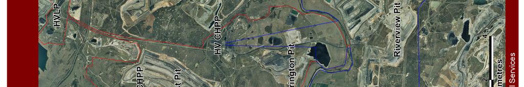
23 5. HVO WATER MANAGEMENT SYSTEM The HVO water management system consists of a network of infrastructure (i.e. dams, pipelines, contour banks) to control the movement of water around the site. The elements of the water management system are depicted geographically in Figures 2, 3 and 4 Water Management Infrastructure and schematically in Figures 5, 6 and 7 Mine Site Water Management System Schematic. Water is managed according to type. Water type is determined by catchment source, quality and use. The main types of water managed at HVO include: accumulates at low points in the open cut pits. HVO holds water licences for groundwater abstraction resulting from pit excavations. Drawdown loss of alluvial groundwater or river flows are managed via an internal water account. Extracted volumes are provided annually in the Annual Environmental Management Report (AEMR). Pit water is pumped to out of pit storage dams or to available in-pit storages using mobile diesel pumps and relocatable high density polyethylene (HDPE) pipelines. Priority is given to water that accumulates in active mining areas, followed by areas to be mined in the short term, and last of all, inactive mining areas. The majority of dewatering is directed to: Parnells Dam (Dam 9W at West Pit) Mine Water Dam 9N at Carrington/North Pit Runoff Water Barry s Void (Dam 31S ) at South Pit River Water 5.1 Mine Water Water used in coal production at HVO is predominantly saline due to interaction with saline groundwater within coal seams and contact with saline mine spoils. Saline water cannot be released from site except for opportunistic discharges as regulated by the HRSTS. There are three main streams of saline water managed at HVO: Pit Water; Coal Handling Preparation Plant (CHPP) Water Supply; and Tailings Water. These three streams of saline water become so thoroughly intermixed as to be indistinguishable, and they are generically referred to as mine water Pit Water Pit water consists of rainfall-runoff, groundwater seepage, spoils seepage and tailings dam seepage that Water is pumped between HVO South and HVO North via pipelines across the Hunter River haul road bridge. Water is pumped between HVO North and HVO West via pipelines between Dam 9W and Dam 9N. Water from the open cuts can be moved in both directions using these pipelines, although the majority of flows are from HVO South to HVO North. Surplus mine water from Carrington and South Pits is directed primarily to Dams 9N and 31S respectively, which ultimately feed water to the HVO North CHPP. In-pit dust suppression consumes large quantities of mine water via fast fill water cart stations located at West, North and South Pits. Once CHPP and dust suppression usage is met, excess mine water is retained in the storages set out in Table 5.2. Large mine-water dams have sufficient free-board capacity maintained to prevent overtopping during heavy rainfall events CHPP Water Supply The North CHPP and the Howick CHPP are the main consumers of water at HVO. 23
24 5.1.3 Tailings Water There are two active tailings dams: North Pit Tailings Dam (Dam 29N) and Dam 6W; and three inactive facilities known as Dam 27N, Dam 28N and Dam 20W (Bob s Dump Tailings Dam). Active and inactive tailings facilities are managed in accordance with environmental procedures for coarse rejects and tailings disposal, and Operational and Maintenance manuals in accordance with requirements for management of prescribed dams. 24


25 Figure 2

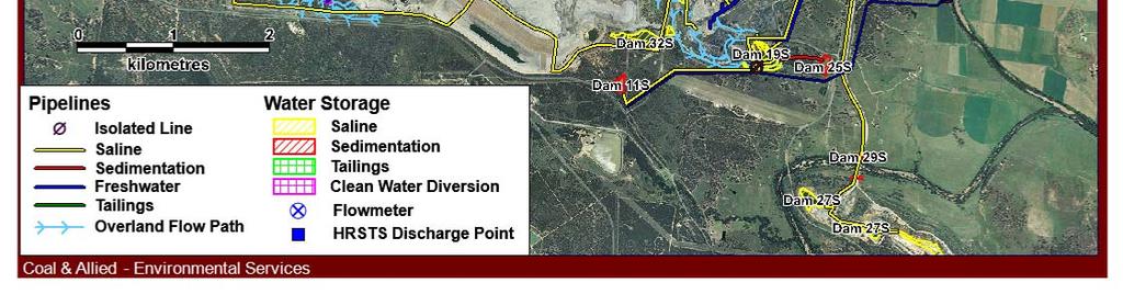
26 Figure 3
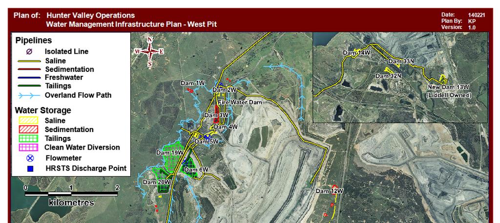

27 Figure 4
28
29
30
31 5.3 Runoff Water Runoff waters vary in quality depending on the characteristics of the catchment area. Runoff water is captured or diverted away from the mine water system dependent on quality, climatic conditions and production requirements. Broadly, runoff water can be split into four types based on catchment characteristics: clean catchment; unconsolidated mine spoil; rehabilitated mine spoil; and active mining areas. Current catchments at HVO are shown in Figures 8, 9 and 10. disturbed by ancillary mining activities (e.g. road construction or car-parks) has the potential to produce degraded water. Prior to release from site this water is managed to minimise sediment load. Sediment control structures are implemented generally in accordance with Managing Urban Stormwater Volume: 2E mines and Quarries Unconsolidated Mine Spoil Based on exposed area, unconsolidated mine spoil contributes the largest volume of rainfall runoff into active pits. In addition, due to the high porosity of mine spoil a large proportion of incident rainfall actually reaches the pit as seepage through the mine spoil, accumulating salt as it flows. Most water reaches the active pit in a matter of hours or days, however amongst block tipped spoil, heterogeneous layering can delay breakthrough of seepage for longer periods. Mine water from active mining areas has been discussed in Section 5.1 above Contributing Catchments Catchment boundaries are defined as either reporting to or exit the HVO Environmental Protection Licence (EPL) boundary. Using this approach broader regional catchments have been identified enabling increased understanding of how the operation sits within the landscape, in terms of surface water, and guidance of future water management / catchment works. Figures 8, 9 and 10 illustrate the HVO EPL and the outer most example of catchments that have a risk, no matter how remote, of being impacted by the HVO mining operation catchments Clean Catchment Runoff water quality is variable and predominantly influenced by prevailing climatic conditions. Runoff water from unconsolidated mine spoil will be captured in the mine water system Rehabilitated Mine Spoil The fate of runoff from rehabilitated mine spoil will be determined by commitments in the Mine Operations Plan (or Rehabilitation and Environmental Management Plan). Sediment laden runoff will be managed in the same way as disturbed clean catchment until groundcover is established. Water that infiltrates into rehabilitated mine spoil will generally continue to move down dip towards mining areas due to groundwater depressurisation. Clean catchment consists of non-mined and ancillary catchment. Catchment and diversion structures for clean water are installed with consideration to Harvestable Rights quantities (Water Management Act 2000 (NSW) [WMA Act]) and storm induced flood flows into operating pits. Clean water diversion structures are employed to divert clean water away from the active pits. Diversion structures are currently employed for West Pit, North Pit and South Pit. Clean catchment which has been 31

32

33

34
35 5.4 River Water Hunter Valley Operations holds both High and General Security Water Access Licences to withdraw water from the Hunter River. Should HVO require more water, entitlements can be traded to this licence in accordance with the WMA to increase output through the scheme. Water licences are detailed in Table 5.1. The combined entitlement is 4,665 Units (ML/annum or a share of the available resources). The currently licensed water extraction volume of 4,665 ML/a is adequate for both HVO North and HVO South requirements provided internal water use continues to be actively managed, and provided high security water licence allocations are maintained at the current levels. Table 5.1: CNA Water Licences Licence No. DWE Reference Share Component (Units) Location/Purpose AL , AL AL AL Hunter River between Gouldbourn River junction and Glennies Creek junction. Used mainly for HVCPP, truckwash and dust suppression when required. Hunter River between Glennies Creek junction and Wollombi Brook junction. Previous and proposed use mainly for LCPP and dust suppression when required. Hunter River between Glennies Creek junction and Wollombi Brook junction. Previous and proposed use mainly for LCPP and dust suppression when required. Hunter River between Glennies Creek junction and Wollombi Brook junction. Previous and proposed use mainly for LCPP and dust suppression when required. All licences have continuing tenure and do not limit extraction rates or times. 35
36 5.6 Water Disposal Excess mine water can be released via licensed discharge points into the Hunter River. Licensed discharge points are located on: Parnells Dam (9W), Dam 11N and Lake James (Dam 15S). Discharges are only allowed during high and flood flow periods in the Hunter River as determined by State Water and the DPI Water. Discharges are regulated by conditions in the site EPL 640 and by the Hunter River Salinity Trading Scheme Regulation HVO is also licensed in its EPL 640 to discharge water from its Alluvial Lands. This discharge point has specific discharge parameters and is not regulated under the Hunter River Salinity Trading Scheme. Discharge parameters are in accordance with EPL 640 and only allow for discharge of fresh quality water. 5.7 Water Storages Providing sufficient water storage capacity provides a buffer against drought and flood interruptions to the business and prevents unlicensed discharge of polluted water offsite. HVO utilises disused mining voids and large out of pit dams to provide buffer storage. The capacity and status of large storages located at HVO are listed in Table 5.2. In addition to the main water stores a series of smaller dams provide buffer storage for production and ancillary demands. A water licence was recently secured to access water from the decommissioned Lemington underground mine workings. The production bore can supply water to both HVO and the neighbouring Mount Thorley Warkworth (MTW) mining operation during dry conditions. In addition HVO is drawing water from the backfilled North Pit spoils (below the Alluvial Lands). 5.8 Drainage lines on rehabilitation sites Drainage lines are designed as part of the Mine Operations Plan (or Rehabilitation and Environmental Management Plan). Table 5.2: Large Storages at HVO Storages in Excess of 200 ML Operating Capacity (ML) 9W - Parnells N South East Sump N North Pit Void 17,000 15S Lake James S Old East Cut S - South Lemington Void 900 Riverview Pit Void 4,000 36
37 6. SITE WATER BALANCE 6.1 Overview The model has been configured to simulate the operations of all major components of the water management system including: HVO has developed a representative water balance model utilising the OPSIM Operational Simulation Program. The OPSIM operational simulation model was initially set up in 2007, and has since been regularly updated and calibrated when new data has been made available (most recently in 2013). HVO uses the water balance to record and assess water flux, but also to forecast and plan water management needs. These annual site water balances are then compared to previous results. Site water balance reviews were covered in the Environmental Assessment for Carrington West Wing 2010 (HVO North only; Volume 2, Appendix D). Climatic variability rainfall and evaporation; Catchment runoff and collection; Pit dewatering; Pump and gravity transfers; Water storage filling, spilling and leaking; Industrial water extraction, usage and return; and Discharge to the Hunter River under the HRSTS. Table 6 shows a summary water balance for 2013 at HVO. 37
38 Table 6: 2013 HVO Water Balance Water Stream Volume (ML) Inputs Fresh Water (potable) 30 (<1%) Groundwater 1,365 (16%) Rainfall Runoff 4,955 (57%) Recycled to CHPP from Tails & Storage (not included in total) 1,747 Imported (Liddell) 53 (<1%) Water from ROM Coal 1,363 (16%) Diverted water 954 (11%) Total Inputs 8,720 Outputs Dust Suppression 1,900 (24%) Evaporation - Mine Water & Tailings Dams 1,700 (22%) Entrained in Process Waste 917 (12%) Discharged (HRSTS) 0 Sent to 3 rd Party (Liddell) 17 (<1%) Sent to 3 rd Party (MTW) 376 (5%) Diverted water 954 (12%) Water in Coarse Reject 603 (8%) Water in Product Coal 1,332 (17%) Total Outputs 7,799 Change in Pit Storage (increased)
39 6.2 Sources & Security of Water Supply Water is supplied to HVO through a number of sources, including: Rainfall runoff 6.4 Off-Site Water Transfers and Discharges Saline water cannot be released from site except for opportunistic discharges as regulated by the Hunter River Salinity Trading Scheme (HRSTS). Pit groundwater inflows Moisture entrained in ROM coal Additional sources of poor quality water are also available from the Lemington Underground Bore and inter-site transfer. Abstraction of water from the Hunter River water is also available should alternative sources be unavailable (see Section 5.3). Controlled discharges are undertaken in accordance with the HRSTS as specified in the EPL. Any discharges of water that are required are managed under the guidelines of the HRSTS. HVO is typically a net generator of water; that is, the water captured via rainfall runoff and pit groundwater inflows is generally greater than the water demand. Coupled with significant mine void and out of pit storage capacity external sources of water are not typically required unless prolonged drought conditions occur. Significant High Security Water holdings for the Hunter River are available as contingency should poor quality water sources be exhausted. Regular updates to the HVO water balance model will ensure currency with the current operational configuration of the mine water management system. 6.3 Water Sharing with Neighbouring Mines HVO seeks to use non-potable sources of water preferentially prior to accessing water from the Hunter River under the Water Sharing Plan. Typically excess water is stored on site, however piping infrastructure is in place to transfer water to MTW via Dam 27S (Lemington void). A water transfer agreement is in place with the Glencore Liddell mine. During average conditions, water is transferred from the Liddell mine to HVO s train load points for use, due to the proximal location of the operations. In drier than average conditions HVO (where possible) would seek to transfer surplus mine water from neighbouring mines to supplement its water demands. Infrastructure is currently in place that allows the transfer of water to and from the Peabody Wambo mine. 39
40 7. SURFACE WATER MANAGEMENT PLAN 7.1 Overview HVO has built up a large knowledge base from more than 30 years of surface water monitoring providing detailed baseline data of surface water flows and quality in watercourses that could be affected by the project. Creek, Emu Creek, Comleroi Creek, Pikes Creek and Carrington Billabong. Baseline data for HVO and receiving waters are detailed in the Carrington West Wing EA for HVO North ( ). Recent electrical conductivity (EC), ph and total suspended solids (TSS) data for 2009 to 2012 are given in Tables 7.1, 7.2 and 7.3 below. The HVO surface water management plan is detailed in the following sections. The plan includes: Baseline water quality and flow assessment; Detailed plans of mine water infrastructure; Erosion and sediment controls; Performance criteria for the water management system, surface water quality and stream and riparian vegetation health; and Water quality and flow trigger response plans. 7.2 Water Quality and Water Flow Water quality data is collected for water courses, ephemeral streams and water bodies that could be affected by the project. These sites are detailed in the Hunter Valley Operations Surface Water Monitoring Programme in Appendix D. The main water courses potentially affected by mining at HVO are the Hunter River and Wollombi Brook. The Hunter River is sampled from seven monitoring locations adjacent to HVO to monitor the impact of mining on the Hunter River. The Hunter River monitoring sites extend from Moses Crossing upstream (Site W109) to just downstream of the Wollombi Brook confluence (H3). The Wollombi Brook is sampled from three monitoring locations upstream and downstream of operations. Water quality is also monitored in several ephemeral watercourses: Parnells Creek, Farrells Creek, Davis 40
41 Table 7.1: Historical Surface Water Results for 2009 to 2012 ph Location 2009 Min Max 2010 Min Max 2011 Min Max 2012 Min Max H H H W W W W W WL Warkworth Bridge Bayswater Creek Upstream N/A N/A N/A N/A N/A N/A Bayswater Creek Midstream N/A N/A N/A N/A N/A N/A Bayswater Creek Downstream N/A N/A N/A N/A N/A N/A Comleroi Creek NSW 2 Emu Creek Pikes Creek Upstream N/A N/A N/A N/A N/A N/A Pikes Creek Downstream N/A N/A N/A N/A N/A N/A W11 Farrells Creek NM NM Carrington Billabong NM NM NM NM NM NM NM NM NSW 1 Parnell s Creek 8.7* 8.7* 9.6* 9.6* 9.2* 9.2* NM NM NSW 3 Davis Creek 7.2* 7.2* NM NM NM NM NM NM N/A sampling did not commence at this location until Q NM not measured dry at the time of sampling * - only one sample taken during year, otherwise dry
42 Table 7.2: Historical Surface Water Results for 2009 to EC Location 2009 Min Max 2010 Min Max 2011 Min Max 2012 Min Max H H H W W W W W WL Warkworth Bridge Bayswater Creek Upstream N/A N/A N/A N/A N/A N/A Bayswater Creek Midstream N/A N/A N/A N/A N/A N/A Bayswater Creek Downstream N/A N/A N/A N/A N/A N/A Comleroi Creek NSW 2 Emu Creek Pikes Creek Upstream N/A N/A N/A N/A N/A N/A Pikes Creek Downstream N/A N/A N/A N/A N/A N/A W11 Farrells Creek NM NM Carrington Billabong NM NM NM NM NM NM NM NM NSW 1 Parnell s Creek 2630* 2630* 520* 520* 1300* 1300* NM NM NSW 3 Davis Creek 230* 230* NM NM NM NM NM NM
43 Table 7.3: Historical Surface Water Results for 2009 to2012 TSS Location 2009 Min Max 2010 Min Max 2011 Min Max 2012 Min Max H H H W W W W W WL Warkworth Bridge Bayswater Creek Upstream N/A N/A N/A N/A N/A N/A 5 6 Bayswater Creek Midstream N/A N/A N/A N/A N/A N/A 5 9 Bayswater Creek Downstream N/A N/A N/A N/A N/A N/A 6 38 Comleroi Creek NSW 2 Emu Creek Pikes Creek Upstream N/A N/A N/A N/A N/A N/A Pikes Creek Downstream N/A N/A N/A N/A N/A N/A W11 Farrells Creek 3 8 NM NM Carrington Billabong NM NM NM NM NM NM NM NM NSW 1 Parnell s Creek 11* 11* 8* 8* 2* 2* NM NM NSW 3 Davis Creek 4* 4* NM NM NM NM NM NM
44 7.3 Water Management System Clean Water Diversions Clean water diversion structures are employed to divert clean water away from the active pits. Prior to release from site this water is managed to minimise sediment load. Sediment control structures are implemented generally in accordance with Managing Urban Stormwater Volume: 2E mines and Quarries. Figure 11 HVO Water Management Schematic shows the OPSIM mine water management schematic for HVO. Progressively stripping and stockpiling topsoil for later use in rehabilitation and stabilisation; Stabilising topsoil stockpiles to minimise erosion; Progressively rehabilitating disturbed land to increase ground cover, increase infiltration and reduce erosion potential; Constructing drainage controls such as scour protection to improve stability in concentrated flow areas; and Erosion and Sediment Control Overview A Ground Disturbance Permit is required for all disturbance activities. Prior to disturbance, appropriate erosion and sediment controls consistent with current best practice standards will be established. Where ground conditions allow, erosion and sediment controls will be designed generally in accordance with the Blue Book : Managing Urban Stormwater: soils and construction (Volume 1 and 2E Mines and Quarries). Sediment mobilisation and erosion will be minimised by; Where practical, diverting runoff from undisturbed catchments around disturbed areas via diversion drains and banks to discharge into natural watercourses; Restricting access to rehabilitation and nondisturbed areas Potential Impacts from Mining Activities that have the potential to cause erosion at HVO include: Vegetation clearing and topsoil stripping; Stockpiling of topsoil; Rehabilitation Vehicle movements Construction of roads and infrastructure; and Construction of overburden dumps. Retaining runoff from disturbed areas in sediment dams to settle out suspended sediment with possible treatment prior to discharge back to the natural system; Return water back to the mine water system if water quality is not suitable for release; Installing appropriate erosion and sediment controls prior to disturbance of any land; Limiting the extent of disturbance to the practical minimum and maintaining groundcover; Reducing the flow rate of water across the ground on disturbed surfaces; Potential impacts from these activities include: Increased surface erosion from disturbed and rehabilitated areas through the removal of vegetation and stripping of topsoil; Increased sediment and pollutant load entering the natural water system; and Siltation or erosion of watercourses and waterbodies. In addition to potential impacts from mining other sources of sediment may include: Clearing associated with powerline easements; 44
45 Erosion from disturbed areas created by natural processes; and velocities; this will not be triggered until mining recommences at South Lemington; and Erosion from areas disturbed by previous agricultural land uses Erosion and Sediment Control Structures Contour banks have been positioned at HVO to direct runoff from rehabilitated areas and disturbed areas to sedimentation dams. The locations of the erosion and sediment control structures are shown in Figures 2, 3 and 4. Erosion and sediment control structures will remain in place to divert water away from the Deep Cheshunt Pit final void unless required for use as flood flow storage Flood Mitigation assess Hobden Gully levee (CL1) prior to mine closure to determine if protection of the Deep Cheshunt Pit final void is required. 7.4 Detailed Plans Final Voids The rehabilitation objective of the mine site, including the final void is to be safe, stable and non-polluting. Design and management of the voids will be in accordance with the Mine Operations Plan (or Rehabilitation and Environmental Management Plan). The EA s depict three final voids; two in West Pit and one in Cheshunt Pit. Existing flood mitigation controls in place at HVO include: Evaporative Sink HVO North: o Levee No. 3 (20CW802604) o Carrington Levee No. 5 (20CW802612) o North Pit Levee East (20CW800913) o North Pit Levee Alluvial Lands (20CW801475) The final void evaporative sink in Carrington Pit has been designed to facilitate evaporative losses at a rate which is greater than the accumulation of groundwater within the pit shell, rainfall runoff and infiltration through the rehabilitated final landform. The proposed evaporative sink will be extended to between 85 to 100ha to accommodate the extended pit shell Carrington West Wing Extension at HVO North Tailings Dams o North Pit Levee West (20CW802604) HVO South: o Barry s Levee and Barry s Levee South (20CW802613) o Hobden Gully Levee (20CW802603) HVO will: construct South Lemington Pit 2 Levee SLL2 as a permanent levee and ensure the outer face of the levee will withstand 100-year ARI flood flow Table 7.4 details the current tailings impoundments at HVO and the status of each facility. The locations of each facility is shown in Figures 2, 3 and 4. Tailings dams are engineered in accordance with the Dams Safety Act 1978 (NSW) Highwalls adjacent to low permeability barriers Detailed plans, including design objectives and performance criteria for ensuring the stability of high wall adjacent to low permeability barriers as part of the Carrington West Wing Extension will be developed in consultation with the Planning and Environmental (P&E) prior to construction. 45
46 Table 7.4: current tailings impoundments at HVO and their status Storage Location Status Proposed rehabilitation North Pit Void (29N) North Active 2022 Dam 6W West Active 2025 Centre (28N) North Decommissioned 2018 South East (27N) North Decommissioned 2016 Bobs Dump (20W) West Decommissioned
47
48 8. GROUNDWATER MANAGEMENT PLAN 8.1 Overview Detailed assessments of the potential groundwater impacts of mining at HVO were undertaken using a numerical groundwater model during the EA for HVO North (2003), HVO South (2008) and Carrington West Wing Extension (2010). The model calculated groundwater seepage and drawdown responses for the development, as detailed in this plan. An integrated management approach is employed at HVO to mitigate the potential impacts of mining on the groundwater environment and other groundwater users, including dependent ecosystems. The key groundwater management measures are: 1. Physical water management; 2. Groundwater monitoring, data management and reporting; 3. Groundwater model revisions and verification of predictions; 4. Salinity trading and water sharing; and 5. Direct compensation measures. Overall the studies to date have highlighted that the Carrington West Wing Extension and HVO South operations will pose limited risk to the groundwater regime. By the implementation of these groundwater management measures, any residual risks can be effectively mitigated or managed. 8.2 Water Quality, Levels and Yield Baseline data for HVO, including water levels, quality and yield estimates are detailed in the EA for HVO North (2003), HVO South (2008) and Carrington West Wing Extension (2010). An extensive network of groundwater monitoring bores and piezometers, screening the alluvium, coal seams and interburden is routinely monitored. Recent data is presented in the 2014 HVO Annual Review, including groundwater impacts reports for HVO North and South. ( nual%20review%202014%20final%20reduced%20small est.pdf ) The current groundwater monitoring network is shown in Appendix E. 8.3 Impacts on Groundwater and Monitoring Objectives: Identify potential impacts of coal mining activities upon the uses of groundwater; Groundwater impact assessment criteria; and Exceedance response measures. The groundwater management measures are intended to compliment the groundwater monitoring program given in Appendix E. HVO will continue to meet all commitments under the relevant water sharing and Hunter River Salinity Trading Scheme. Continued groundwater monitoring combined with a 3-yearly review of the site numerical groundwater model will inform future decision making with respect to quantifying impacts on the groundwater environment. HVO has developed a knowledge base from 30 years of groundwater monitoring to provide detailed baseline data of groundwater yield and quality in the immediate region. Groundwater monitoring will be undertaken in accordance with the Groundwater Monitoring Programme in Appendix E. This programme is in accordance with AS :- 1998, Guidance on the Design of Sampling Programs, Sampling Techniques and the Preservation and Handling of Samples and AS , Guidance on Sampling of Groundwaters. In accordance with Schedule 4, condition 27(c) of the HVO North Consent and Schedule 3, condition 27(c) of the HVO South Consent, the Groundwater Monitoring Program should address the predicted impacts. The potential impacts from mining are described in the below sections. For each of these risks some groundwater monitoring works will be considered in addition to the Groundwater Monitoring Programme in Appendix E. 48
49 Commitments related to the development of Carrington West Wing are detailed in Table Groundwater Inflows to the Open Cut Mining Operations Leakage of groundwater from the target coal seams and alluvial aquifers are calculated on an annual basis. The latest figures are given in the Groundwater Impacts Reports for HVO North and South, found in Appendix 4 of the 2014 Annual Review ( nual%20review%202014%20final%20reduced%20small est.pdf ). The calculated groundwater inflows show good agreement with previously modelled leakage estimates in the EA s. As a condition of the Barry s extension approval, dewatering rates within Barry s Pit during mining will be recorded Effectiveness of the Low Permeability Barrier A monitoring program to measure the effectiveness of the low permeability barriers as part of the Carrington West Wing Extension will be developed in consultation with the P&E and DPI Water prior to construction. Performance of the Alluvial Lands Barrier is assessed regularly (frequency) through a series of piezometers along the length of the barrier Base Flows to the Hunter River The impact of mining activities on Hunter River (and Wollombi Brook) baseflow is currently assessed on an annual basis in the Groundwater Impacts Reports for HVO North and South, found in Appendix 4 of the 2014 Annual Review ( nual%20review%202014%20final%20reduced%20small est.pdf ). Base flow of the Hunter River and Wollombi Brook will be monitored via the existing monitoring programme; refer to Appendix E Impact on Private Groundwater Bores It is not anticipated that HVO mining operations will result in any unreasonable loss of groundwater yield at existing privately owned water bores in the local area. There are no privately owned boreholes (excluding those associated with mining operations) that are likely to be yield affected within the predicted envelope of groundwater depressurisation that will surround the mine pit. Nearest boreholes are located about 2.5 km to the south and are situated in Hunter River alluvium. The existing network of groundwater monitoring bores, covering both the coal seams and the alluvium, should be sufficient to ascertain whether a change in private water bore production could be attributed to the HVO operation Impact on Groundwater Dependant Ecosystems Groundwater dependent ecosystems (GDEs) nearby HVO operations are limited to river red gum stands along the Hunter River and Wollombi Brook. The impact on these GDEs is assessed in the EAs. It is not anticipated that groundwater drawdown (as a result of this project) will result in stress to the associated vegetation communities. Whilst the species utilises groundwater, it relies on flooding regimes for recruitment. Current flooding regimes are not predicted to be significantly affected as a result of the project. The Carrington Billabong River Red Gum Rehabilitation and Restoration Strategy outlines the management and monitoring regime to ensure these communities are maintained ( document available at d%20gum%20rehabilitation%20and%20restoration%20 Strategy.pdf ) Seepage/Leachate from Water Storages Overburden removed and dumped as a function of mining is prone to preferential weathering and will tend to leach dissolved salts, which can enter the groundwater and surface water environment. Modelling undertaken concluded that the final void water levels will equilibrate below the regional water table and will therefore act as a sink to groundwater flow in the area. Seepage from voids is therefore not expected to occur. The existing Groundwater Monitoring Programme is currently sufficient to verify voids will operate as designed. To verify that the groundwater is retained in the mine voids at closure HVO should install and maintain permanent floating buoys that measure the water level and electrical conductivity of the void water, combined 49
50 with water level / electrical conductivity loggers fitted into a representative selection of monitoring bores Alluvial Lands Dewatering Management The alluvial lands area of North Pit was mined and subsequently backfilled between the late-1990 s and mid s, following initial approval in The original groundwater modelling predicted the backfilled void would recharge via rainfall runoff and equilibrate to a water quality which would ultimately allow mixing with the Hunter River. To ensure management commitments relating to the water quality objectives for Hunter River mixing could be achieved at some time in the future investigations determined dewatering of the void should be undertaken to reduce the salt load. of one deep dewatering bore is planned for 2015 to increase the rate of dewatering. The existing Groundwater Monitoring Programme and Groundwater Impacts Report are used to monitor and manage alluvial lands dewatering. 8.4 Validation of Groundwater Model Every three years HVO will instigate an independent review (validation and recalibration, if necessary) of the groundwater model. The first 3-year review of the model will be scheduled for late Groundwater Impacts Reports for HVO North and South are undertaken on an annual basis, ensuring verification of monitoring results with modelled predictions. One deep dewatering bore (DM6) and three shallow dewatering bores (DM7, 8 and 9) were constructed as the void was backfilled in the mid-2000 s. The bores were intermittently operated following construction however pumping ceased in June 2007, as site water inventories were full due to heavy rainfall. Shallow bores DM8 and DM9 were re-commissioned in 2013 and provide a low dewatering rate. The construction 50
51 Table 8: onsite monitoring of Stream and Riparian Vegetation Health of the Hunter River WORKS/ACTIONS Two-monthly monitoring of water levels in any new standpipe piezometer in proximity to the Carrington West Wing extension area and quarterly monitoring elsewhere, unless water level changes dictate otherwise. Daily or more frequent monitoring of pore pressures by installed auto recorders at some existing piezometers in order to discriminate between oscillatory groundwater movements attributed to rainfall recharge, and longer term pressure losses related to open cut and underground mining. Construction of additional piezometers. Permeability testing will be completed on new piezometers in order to facilitate estimation of leakage and subsurface flows. two-monthly or quarterly (depending upon location) monitoring of basic water quality parameters, ph and EC, in existing and any new piezometers six monthly measurement of TDS and speciation of water samples in piezometers ESTIMATED TIMING When mining begins in the Carrington West Wing extension area, When mining begins in the Carrington West Wing extension area where deemed necessary, as information is generated from within the existing network, during the course of mining. When mining begins in the Carrington West Wing extension area When mining begins in the Carrington West Wing extension area 51
52 9. ASSESSMENT, REPORTING AND REVIEW 9.1 Performance Criteria & Trigger Levels Trigger values provide the measurable basis for identifying adverse water quality and the basis on which to consider implementing contingency measures, provided there is a large enough data set for statistically robust values. Key analytes include; ph (acidity / alkalinity) Conductivity (EC) Specific groundwater impact assessment criteria are listed in Table 9.2. Performance against these assessment criteria should be reported to the Department of Planning and Infrastructure in the AR. Sufficient baseline groundwater data is available to guide the development and use of the various impact assessment criteria. Impact assessment criteria related to the performance of the Carrington West Wing Low Permeability Barrier will be developed in consultation with P&E and DPI Water prior to construction commencing. Impact assessment criteria and response measures for GDEs are addressed through the Carrington Billabong River Red Gum Rehabilitation and Restoration Strategy. Total Suspended Solids (TSS). HVO s EPL 640 stipulates HRSTS discharge criteria, as detailed in Table 9.1. Table 9.1: Surface Water Impact Assessment Criteria Parameter Unit Measure of Concentration Limit ph ph a Total Suspended Solids (TSS) Notes: a. Permissible range Milligrams litre (mg/l) per 120 b b. Maximum In the absence of licence or applicable ANZECC criteria, the 95th percentile of the available validated data record for a monitoring station will be adopted as the basis for a water quality management guideline trigger value. The calculated trigger values will be incorporated into monthly reviews of monitoring data. Table 9.2: Groundwater Impact Assessment Criteria Criteria Description The groundwater level in the alluvium neighbouring the mine does not exhibit significant divergence from the previous data or from the established or predicted trend Water levels and / or water quality in privately owned water bores and wells identified in the EA s do not decline to the point that water supply is adversely or directly impacted A measurable reduction in flow in the Hunter River and Wollombi Brook upstream and downstream of the HVO mining area does not exceed 10% and is attributable to mining operations 4 The water quality of the riverine alluvium will not vary in excess of 3 standard deviations from long term mean 52
53 9.2 Response to Exceedance & Performance Indicators The following management responses will be routinely implemented as per below. Formal review of measured depressurisation of coal measures and alluvial aquifers will be undertaken annually by a suitably qualified hydrogeologist. The predicted loss of water from the alluvial aquifer and from baseflow in the Hunter River will be offset by ensuring sufficient entitlements are held from the Hunter Regulated River Water Sharing Plan. 9.3 Management of Unpredicted Impacts Contingency measures will be implemented commensurate with the degree of impacts determined by the investigation. Depending on the outcomes of an investigation, one or a number of remedial actions may be taken. Remedial actions for surface water may include: 1. intercepting and pumping the water back into the mine water management system; 2. establishment of containment or diversion systems upstream to prevent the water discharging offsite; HVO would purchase and retire existing water licences from the Wollombi Brook Water Source Zone for the predicted loss of water from the alluvial aquifer and from baseflow in Wollombi Brook if required. 3. establishing controls to improve the water quality; and/or 4. cease or modify any activity that may be degrading the water quality; and/or In the event that a water quality measurement exceeds a predetermined trigger value, exceedances will be recorded and HVO will initiate a site specific investigation if: professional judgement determines that the single deviation or a developing trend could result in environmental harm. three consecutive measurements of EC or ph exceed trigger values. 5. additional water licences or water allocations will be sourced if required to ensure that HVO s water allocation is not exceeded. Remedial actions for groundwater may include: 1. more intensive monitoring and/or seeking professional advice in regards to model predictions; and/or 2. geotechnical investigations; and/or One measurement of TSS exceeds the trigger value. The investigation will: 3. structural assessments; and/or 4. consideration of changes to the mine plan if required. Determine the source and risk of impact on downstream water quality. Determine the need for and extent of contingency measures. Monitoring and reporting would be continued to demonstrate the effectiveness of the actions in remediating the water excursion. 9.4 Reporting Communicate outcomes to senior management Be reported in the AR. The process for compliance reporting is described in Table
54 Table 9.3: Water quality management reporting Reporting aspect Relevant Legislation What is reported When Who to report to Results of water monitoring undertaken in accordance with the requirements of this approval Condition 9 of Schedule 6 of the HVO North Consent (DA ) & Condition 9 of Schedule 6 of HVO South Consent (06_0261) Monitoring results Monthly Public The Coal Australia website ( in accordance with the HVO Online Communication Plan. & The HVO Community Consultative Committee (CCC) Results of PoEO Act, Monitoring results Within 14 Public monitoring Schedule 2, days of collected in Section 66 receipt - accordance reported on with EPL the RTCA website (monthly summary) Annual Review Condition 5 All water monitoring By the end Relevant stakeholders including but not of Schedule results for the of March limited to EPA, P&E, Singleton Council 6 of the HVO corresponding year. each year and Community Consultative Committee North The Annual Review (CCC) Consent will also detail any (DA complaints relating 2003) to water quality received at HVO & Condition 9 of Schedule 6 of HVO South Consent 54
55 Reporting aspect Relevant Legislation What is reported When Who to report to (06_0261) Potential or Details of potential By The Environmental Specialist reports to confirmed Coal or confirmed exception the Environmental Services Manager exceedance / Australia exceedance / noncompliance HSEQ14 noncompliance of of water Incident and water triggers triggers Action incidents (internal Management reporting) Trigger Details of the Following NSW Office of Water via to exceedance Coal trigger exceedance exceedance information@water.nsw.gov.au (marked investigation Australia investigation and investigation attention to Mitchell Isaacs) determines HSEQ14 contingency contingency Incident and measures to be measures Action enacted required Management Incident PoEO Act, Details of incident Immediately The Environmental Specialist Operations causing or Section 148 following in writing to the P&E, and EPA threatening to receipt of cause information Environmental indicating harm actual or potential harm Water use Water Water supply and Annually Reported on in the AR and in accordance Access use with Water Licence requirements. Licence under the WMA NB: Where conditions of Water Licences issued by NoW dictate, a compliance report, which reports on 55
56 Reporting aspect Relevant Legislation What is reported When Who to report to the results of the Groundwater Monitoring and Contingency Plan required by a Water Licence, will be lodged DPI Water Annual Water Act report on: Annually submitted to DPI Water Environmental 1912 Audit Report compliance with 20BL the terms and conditions of the 20BL relevant Water Licence, including 20BL any Groundwater Monitoring and 20BL Contingency Plan; Actual impacts of the extractions on any aquifers, groundwater dependant ecosystems and any streams in the area; The difference between actual and predicted impacts (modelled results); and Recommendation s as to works that ought to be performed or additional obligations that ought to be imposed in order to rectify any impacts on groundwater. 56
57 9.6 Continuous Improvement 9.5 Complaints Management Community Complaints are lodged via the Community Complaints line ( ). The hotline number will be prominently displayed on the Coal Australia website, and regularly advertised in the local newspaper. The Complaints Hotline will be in operation 24 hours per day, seven days a week. Complaints will be recorded and investigated by HVO staff. All other complaints lodged via letter, in person or by fax, will also be recorded and investigated by the Environmental Coordinator. In accordance with the requirements of the Coal Australia Health, Safety, Environment and Quality Management System, HVO will continuously seek to further water management by way of improving existing controls and investigating new and emerging technologies, implementing new controls where required, and thoroughly investigating any exceedance and noncompliance events. All complaints will be investigated, and, where the investigation identifies potential non-compliance with a consent or licence condition, mitigating action will be taken. The details of all water related complaints, and any mitigating actions taken, will be circulated to senior management. Where requested, follow-up correspondence with the complainant will be provided. In accordance with the conditions of EPL640 relating to handling of pollution complaints, HVO will maintain a register of complaints, recording the following information (at minimum): Date and time of the complaint Method by which the complaint was made Any personal details of the complainant which were provided The nature of the complaint Any action taken in relation to the complaint If no action, the reason why no action was taken A record of each complaint will be kept for a minimum of four years, and will be produced on request to any authorised officer of the EPA. 10. Roles and Responsibilities Table 10: Roles and Responsibilities Manager Mining
58 Ensure that water is managed in compliance with the WMP and Coal & Allied Water Management procedures within area of accountability. Delegate a representative for the Water Management Operations Team. Ensure water infrastructure in the mining area is regularly inspected and maintained. Specifically: o Maintain dewatering capability. o Ensure systems to protect against sudden inrushes of water are operational. o Mitigate spills, leaks and unlicensed discharges. Ensure water supply from the mine meets supply demands of the CHPP s. Ensure water management infrastructure is designed and constructed in accordance with this WMP and Coal & Allied Water Management procedures. Manager Environmental Services Manager CPP Ensure a site Water Management Plan is prepared, implemented & maintained. Ensure surface and groundwater monitoring programmes are implemented and current. Ensure review and reporting of water data is consistent with regulatory requirements. Administer and ensure compliance with water licenses. Design and budget for the construction of small to medium cleanwater diversions and, sediment/erosion control structures and discharge facilities. Arrange monthly water management infrastructure inspections and storage facility inspections as required. Manage releases of water for the mine site so that releases comply with statutory requirements. Advise Managers for Short, Medium and Long Term Mine Planning on water management control & planning requirements. Prepare site water balances that define water use, storage and discharge requirements. Regularly monitor the availability, use, quality and discharge of water with licence requirements and relevant site management plans. Delegate a chairperson for regular water management operations team meetings. Ensure that water is managed in compliance with the WMP and Coal & Allied Water Management procedures within area of accountability. Delegate a representative for the Water Management Operations Team. Ensure water infrastructure in the CHPP area of accountability is regularly inspected and maintained. Specifically: o Ensure preferential use of poor quality water over river water. o Mitigate spills, leaks and unlicensed discharges. Ensure water is ordered and administered in accordance with the WMA. Ensure water management infrastructure is designed and constructed in accordance with this WMP and Coal & Allied Water Management procedures. Communicate the WMP to relevant members of team. Maintain operational procedures and work instructions for the management of water in the CHPP area. Manager Maintenance Ensure that water is managed in compliance with the WMP and the Coal & Allied Water Management procedure within area of accountability. Delegate a representative for the Water Management Operations Team. Ensure water infrastructure in the Maintenance area of accountability is regularly inspected and maintained. Specifically: 58
59 o o Ensure preferential use of poor quality water over river water. Mitigate spills, leaks and unlicensed discharges. Ensure planned maintenance schedules are implemented to maintain the availability of fixed and mobile pumps in the mining area. Ensure water management infrastructure is designed and constructed in accordance with this WMP and Coal & Allied Water Management procedures. Communicate the WMP to relevant members of team. Maintain operational procedures and work instructions for the management of water in the Maintenance area. Manager Technical Services Incorporate surface and ground water management into mine planning and landform design. Manager Operations Support and Projects Ensure that water is managed in compliance with the WMP and Coal & Allied Water Management procedures within area of accountability. Delegate a representative for the Water Management Operations Team. Ensure water infrastructure in the OS&P area of accountability is regularly inspected and maintained. Specifically: o o Install sediment and erosion control for ground disturbance activities. Mitigate spills, leaks and unlicensed discharges. Budget for and provide EPCM for medium to large scale water management projects. Provide supervision and construct small water management projects.. Budget for the maintenance of all permanent clean, sediment, erosion control and mine water drains and dams. Maintain operational procedures and work instructions for the management of water in the Projects work area. Communicate the WMP to relevant members of team. 59
60 11. Review The WMP will be reviewed within three months of the submission of the AR and updated to the satisfaction of the Director-General of the P&E where necessary. The WMP will also be reviewed within three months of the completion of an independent environmental audit, any exceedance of the Approvals criteria or any modification to the conditions of the Approvals. Any major amendments to the WMP that affect its application will be undertaken in consultation with the appropriate regulatory authorities and stakeholders. Minor changes such as formatting edits may be made with version control on the Project website. The WMP may also be revised due to: deficiencies being identified; introduction of additional mitigation measures or controls; results from the monitoring and review programme, including exceedances of criteria; recommendations resulting from the monitoring and review programme; changing environmental requirements; improvements in knowledge or technology becoming available; changes in legislation; identification of a requirement to alter the WMP following a risk assessment; or, updating of the Mining Operation Plan. 60
61 REFERENCES Project Approval - DA Project Approval - DA 06_0261. The Environmental Impact Assessment titled Hunter Valley Operations West Pit Extension and Minor Modifications, dated October 2003, and prepared by Environmental Resources Management Australia. The Carrington West Wing Environmental Assessment, dated 1 October 2010, and prepared by EMGA Mitchell McLennan (CWW EA). The Environmental assessment titled Hunter Valley Operations South Coal Project Environmental Assessment Report, Volumes 1, 2 and 3, dated January 2008, including the response to submissions. 61
62 Appendix A Director General s Endorsement of Suitably Qualified and Experienced Author


63
64 Appendix B Correspondence with NOW and the EPA
 We refer to condition 27 of Schedule 4 of Hunter Valley Operations -")
65 30 April 2014 Mitchell Isaacs NSW Office of Water PO Box 2213 DANGAR NSW 2309 Dear Mr Isaacs RE: Coal & Allied Operations Pty Ltd s Hunter Valley Operation s North, Water Management Plan Condition 27 of Schedule 4 of DA as modified on 19 March 2013 & South DA 06_0261 Water Management Plan (Schedule 3, Condition 27) We refer to condition 27 of Schedule 4 of Hunter Valley Operations - North Development Consent (DA ) which was modified by the Planning and Assessment Commission as delegate for the minister for Planning on 19 March 2013 and subsequent Barry s Pit Extension approval, granted on 15 January 2014, requiring a revision of the Water Management Plan under Schedule 3, Condition 27 of the Hunter Valley Operations South Development Consent. Under conditions of each consent Coal & Allied Operations Pty Ltd is required to prepare and implement a Water Management Plan (WMP) for the development (Hunter Valley Operations North and Hunter Valley Operations - South). It is a requirement that these plans are: prepared in consultation with NOW and the EPA, and submitted to the Director-General for approval by the end of September 2013 (for HVO North) and by 30 April 2014 (for HVO South) unless otherwise agreed. Coal & Allied Operations Pty Ltd ABN Lemington Road, Ravensworth via Singleton NSW 2330 Australia PO Box 315 Singleton NSW 2330 Australia Telephone Facsimile
66 By letter dated 29 August 2013 the Director-General of the Department for Planning and Infrastructure (Director-General) approved a request by Coal & Allied for an extension to the submission date for the WMP until 31 December We enclose a revised WMP for your consideration and comment, incorporating the comments received from Planning & Infrastructure on 4 February 2014 and the conditions of the Barry s Pit Extension approval. This WMP therefore supersedes that previously submitted on 20 December 2013, noting feedback has yet to be received from the NSW Office of Water on the first draft of the WMP. This plan was submitted by Coal & Allied to the Director-General today (30 April 2014). We have notified the Director-General that a copy of this plan is only being sent to you for consultation today and on that basis, that if any comments are received which Coal & Allied determines appropriate for inclusion, a revised plan will be prepared and reissued for approval by the Director-General. We would be grateful if you could please advise of the EPA s position in this regard by 30 June We look forward to hearing from you. Yours sincerely Chris New Environmental Specialist T: +61 (0) M: +61 (0) chris.new@riotinto.com


67
68 Appendix C Surface Water Monitoring Programme
69 Environmental Monitoring Programme HUNTER VALLEY OPERATIONS SURFACE WATER MONITORING PROGRAMME 1 Purpose This document provides a summary of the surface water monitoring programme for Hunter Valley Operations. The monitoring locations are subject to change and will be updated periodically to align with management needs and to accommodate progression of mining. 2 Programme Surface Water Monitoring Table 1: Surface Water Monitoring Overview Page 1 of 4 Frequency & Parameter Monitoring Location Comprehensive EC ph Analysis 1 TSS Barellan RE RE A RE Bayswater Creek Downstream RE RE A RE Bayswater Creek Mid RE RE A RE Bayswater Creek Upstream RE RE A RE Carrington Billabong RE RE A RE Carrington Downstream RE RE A RE Carrington Upstream RE RE A RE Coal Loader Dam (HVLP, Bayswater) Q Q - Q Comleroi Creek RE RE A RE Dam 11N Q Q A Q Dam 16W Q Q - Q Dam 18W Parnell s Ck Q Q A Q DM6 North Void Tailings Q Q A Q Emu Ck Sed Dam Q Q A Q EOC (Dam 16S) Q Q - Q H1 Hunter R (upstream K Dam) Q Q A Q H2 Hunter R. Q Q A Q H3 Hunter River downstream Wollombi Q Q A Q K Dam/ Lake James Q Q 6M Q NSW1 (Parnells Ck) RE RE A RE NSW2 Emu Ck RE RE A RE NSW3 Davis Ck RE RE A RE
70 Environmental Monitoring Programme Pikes Creek Downstream RE RE A RE Pikes Creek Upstream RE RE A RE Redbank Creek Catchment RE RE A RE W1 Hunter River (Carrington) Q Q A Q W109 Hunter R. Moses Crossing Q Q - Q W11 Farrells Ck Lemington Rd RE RE A RE W2 Wollombi Bk Q Q A Q W3 Hunter River Q Q - Q W3 Parnells Ck Dam Q Q A Q W4 Hunter River (Oaklands) Q Q A Q W5 Farrells Ck downstream Q,S2 Q A Q W5 Farrells Ck upstream Q,S2 Q A Q W9 (Dam 14W) Q Q A Q Warkworth Bridge Wollombi Bk Q Q A Q WL1 Wollombi Bk Q Q A Q WLP3 6M 6M 6M - 1 Comprehensive analysis includes major ions TDS, Al, As, B, Ca, Cd, Cl, (CO3), Cu, Hg, K, Mg, Na, Ni, Pb, Se, SO4 (or S), Zn, Total Alkalinity, Bicarbonate Alkalinity, Carbonate Alkalinity, Hydroxide Alkalinity. RE Rain Event sampling ( 30mm rainfall in 24hrs, max 2 sampling events per quarter), Q Quarterly, 6M Six Monthly, A Annual, A* - Annual comprehensive analysis to be undertaken on the first rain event sampling occasion for the year, S2 Special sampling during discharge) Methods CNA engages qualified suitably experienced contractors to carry out sampling and analysis. Sampling is undertaken in accordance with relevant Australian Standards and other regulatory guidelines. Samples are analysed by laboratories that are National Association of Testing Authorities (NATA) accredited or equivalent for the parameters being analysed. 3 Impact Assessment Criteria In the absence of licence or applicable ANZECC criteria, the 5 th / 95 th percentile of the available validated data record for a monitoring station will be adopted as the basis for a water quality management guideline trigger. Electrical Conductivity, ph and TSS will be monitored in accordance with the frequency and methodology outlined in Section 2. Trigger levels for investigating potentially adverse surface water impacts are specified in the table below. Trigger limits are calculated as the 95 th percentile maximum value (ph and EC), and the 5 th percentile minimum value (ph) from historical data 2011 current collected from the monitoring station. The 50mg/L ANZECC criteria has been adopted for TSS. Trigger limits have only been calculated for Watercourses. Trigger limits for surface water monitoring locations are summarised in Table 2. The response to trigger levels is detailed in Hunter Valley Operations Water Management Plan (July 2015). Page 2 of 4
71 Environmental Monitoring Programme Table 2: Surface Water Trigger Limit Site Electrical Conductivity ph Total Suspended Solids 95th 5th 95th Bayswater Creek Downstream Bayswater Creek Upstream Bayswater Creek Midstream Carrington Billabong 50 Comleroi Creek H H H NSW 1 Parnells Creek NSW 2 Emu Creek NSW3 Davis Creek 50 Pikes Creek Downstream Pikes Creek Upstream W1 (Hunter River) W W W W3 Hunter River W4 Hunter River WL Warkworth Bridge Page 3 of 4

72 Environmental Monitoring Programme Page 4 of 4
73 Appendix D Groundwater Monitoring Programme
74 Environmental Monitoring Programme HUNTER VALLEY OPERATIONS GROUNDWATER MONITORING PROGRAMME 1 Purpose This document provides a summary of the ground water monitoring programme for Hunter Valley Operations. The monitoring locations are subject to change and will be updated periodically to align with management needs and to accommodate progression of mining. 2 Programme Groundwater Monitoring Location Sample Point Water Comprehensive EC ph Level Analysis TDS 4032P Q Q Q 6M 4034P Q(DL) Q Q 6M 4036C Q Q Q 4037P Q Q Q 6M 4040P Q(DL) Q Q 4051C Q Q Q 4113P Q Q Q 6M 4116P Q Q Q 6M 4117P Q Q Q 6M 4119P Q Q Q 6M Appleyard Farm M(DL) Q Q A B334(BFS) Q(DL) 6M 6M B425(WDH) Q 6M 6M A A B631(BFS) Q(DL) 6M 6M B631(WDH) 6M 6M 6M B925(BFS) Q(DL) 6M 6M A A BC1 RE,Q RE,Q RE,Q BC1a Q Q Q BUNC45A Q Q Q 6M 6M BUNC45D Q Q Q 6M 6M BZ1-1 Q Q Q 6M 6M BZ1-2 RE,Q RE,Q RE,Q RE,6M RE,6M BZ1-3 Q(DL) Q Q 6M 6M BZ2A(1) Q(DL) Q Q BZ3-1 Q Q Q BZ3-3 Q BZ4A(2) Q(DL) BZ8-2 Q Q Q 6M 6M C122(WDH) 6M 6M 6M C122(BFS) Q Q Q C130(AFS1) 6M 6M 6M A A C130(ALL) Q Q Q A A C130(BFS) 6M 6M 6M C130(WDH) 6M 6M 6M C317(BFS) Q 6M 6M Alk/Acidity Page 1 of 8
75 Environmental Monitoring Programme Page 2 of 8 C317(WDH) Q 6M 6M C613(BFS) Q 6M 6M C621(BFS) Q 6M 6M C630(BFS) 6M 6M 6M C809 (GM/WDH) 6M 6M 6M C919(ALL) M Q Q A A CFW55R Q(DL) Q Q 6M 6M CFW57 Q Q Q 6M 6M CGW32 Q Q Q CGW39 Q(DL) Q Q 6M 6M CGW45 Q Q Q CGW45a Q Q Q CGW46 Q Q Q 6M 6M CGW47a Q(DL) Q Q 6M 6M CGW49 Q Q Q CGW51a Q(DL) Q Q CGW52 Q(DL) Q Q CGW52a Q(DL) Q Q CGW53 Q Q Q CGW53a Q Q CGW53a Q(DL) Q Q CGW55a Q(DL) Q Q CHPZ10A Q Q Q 6M 6M CHPZ12A Q(DL) Q Q 6M 6M CHPZ12D Q(DL) Q Q 6M 6M CHPZ1A Q Q Q 6M* 6M CHPZ2A Q(DL) Q Q 6M 6M CHPZ3A Q(DL) Q Q 6M 6M CHPZ3D Q(DL) Q Q 6M 6M CHPZ4A Q Q Q 6M 6M CHPZ8A Q Q Q 6M 6M CHPZ8D Q(DL) Q Q 6M 6M D010(BFS) 6M 6M 6M D010(GM) 6M 6M 6M A A D010(WDH) 6M 6M 6M D214(BFS) Q 6*M 6*M D317(BFS) Q (DL) 6M 6M D317(WDH) 6M 6M 6M D406(AFS) 6M 6M 6M D406(BFS) 6M 6M 6M D510(AFS) 6M 6M 6M D510(BFS) 6M 6M 6M D612(AFS) 6M 6M 6M D612(BFS) 6M 6M 6M D807(BFS) 6M 6M 6M DM1 Q Q Q A A Q DM2 Q Q Q A A Q DM3 Q(DL) Q Q A A Q DM4 Q(DL) Q Q A A Q DM7 Q(DL) Q Q A A Q DM8 Q Q Q A DM9 Q Q Q A A Q E5038/5 Q Q Q 6M 6M G1 Q Q Q A G2 Q Q Q A G3 Q Q Q A GA3 Q Q Q GW_100 Q Q Q A GW_100a (VWP) Q Q Q GW_101 Q Q Q A GW_101a (VWP) Q
76 Environmental Monitoring Programme GW_102 (VWP) Q GW_103 (VWP) Q GW_104 (VWP) Q GW_105 (VWP) Q GW_106 Q Q Q A GW_107 Q Q Q A GW_108 Q Q Q A GW_109 (VWP) Q GW_110 (VWP) Q GW_114 Q Q Q A GW_115 Q Q Q A H5032/5 Q Q Q A A H5038/5 Q Q Q A A HG2 Q Q Q HG2a Q Q Q Hobdens Well Q Q Q A A HV3(2) Q Q Q LUG Bore M Q Q A NPz2 Q(DL) Q Q A A NPz3 Q(DL) Q Q A A NPz4 Q(DL) Q Q A A NPz5 Q Q Q A A PBO1(ALL) M Q Q A PZ1CH200 Q Q Q PZ2CH400 Q Q Q 6M* PZ3CH800 Q Q Q 6M* PZ4CH1380 Q Q Q PZ5CH1800 Q Q Q S4 RE, Q RE, Q RE, Q RE, A RE, A SR001 6M 6M 6M SR002 6M 6M 6M SR003 6M 6M 6M SR004 6M 6M 6M SR005 6M 6M 6M SR006 6M 6M 6M SR007 (RC_11) Q Q Q 6M Q SR008 (RC_7) Q Q Q 6M Q SR009 (RC_8) Q Q Q 6M Q SR010 (RC_6) Q Q Q 6M Q SR011 (RC_14) Q Q Q 6M Q SR012 (HQ_11) Q Q Q 6M Q WES136C (VWP) Q WES158C (VWP) Q MB14HVO01 Q Q Q 6M MB14HVO02 Q Q Q 6M MB14HVO03 Q Q Q 6M MB14HVO04 Q Q Q 6M MB14HVO05 Q Q Q 6M 1 Comprehensive analysis includes major ions TDS, Al, As, B, Ca, Cd, Cl, (CO3), Cu, Hg, K, Mg, Na, Ni, Pb, Se, SO4 (or S), Zn, Total Alkalinity, Bicarbonate Alkalinity, Carbonate Alkalinity, Hydroxide Alkalinity. *TDS, Al, As, B, Be, Ca, Cd, Cl, CO3, Co, Cu, F, Fe, Hg, K, Mg, Mn, Na, Ni, NH3, NO2, NO3, P, Pb, Rb, Sb, Se, SO4 (or S), SiO2, Sr, Zn, Total Alkalinity, Bicarbonate Alkalinity, Carbonate Alkalinity, Hydroxide Alkalinity. Notes: (VWP) indicates that the bore is fitted with a grouted vibrating wire piezo, ( DL) denotes the presence of a Datalogger RE Rain Event sampling ( 30mm rainfall in 24hrs, max 2 sampling events per quarter), M Monthly, Q Quarterly, 6M Six Monthly, A Annual Methods Page 3 of 8
77 Environmental Monitoring Programme CNA engages qualified suitably experienced contractors to carry out sampling and analysis. Sampling is undertaken in accordance with relevant Australian Standards and other regulatory guidelines. Samples are analysed by laboratories that are National Association of Testing Authorities (NATA) accredited or equivalent for the parameters being analysed. Sampling is undertaken via Bailer method for all samples requiring only ph and Electrical Conductivity. Groundwater bores are purged (3x casing volumes where practical) prior to sample extraction for all samples requiring comprehensive analysis. 3 Impact Assessment Criteria In the absence of licence or applicable ANZECC criteria, the 5 th / 95 th percentile of the available validated data record for a monitoring station will be adopted as the basis for a water quality management guideline trigger. Electrical conductivity and ph will be monitored in accordance with the frequency and methodology outlined in Section 2. Trigger levels for investigating potentially adverse groundwater impacts are specified in the table below. Trigger limits are calculated as the 95 th percentile maximum value (EC and ph) and the 5 th percentile minimum value (ph only) from data collected since Trigger levels have been set on the basis of geographical proximity and target stratigraphy. Bores not listed in the following table have not been assigned trigger limits due to insufficient data for statistical analysis. Trigger limits for these bores will be developed in line with future revisions of the programme as additional data becomes available. The response to trigger levels is detailed in Hunter Valley Operations Water Management Plan (July 2015). Page 4 of 8
78 Environmental Monitoring Programme Groundwater Trigger Levels Site Location Target Seam / Stratigraphy Electrical Conductivity ph 95 th 95 th 5 th B334(BFS) B631(BFS) B925(BFS) C130(BFS) C317(BFS) C613(BFS) C621(BFS) C630(BFS) D010(BFS) D214(BFS) D317(BFS) D406(BFS) D510(BFS) D612(BFS) D807(BFS) B425(WDH) Lemington South Bowfield B631(WDH) C122(WDH) C130(WDH) C317(WDH) C809 (GM/WDH) D010(WDH) C130(AFS1) Lemington South Woodlands Hill D406(AFS) D510(AFS) D612(AFS) BC1a Lemington South Arrowfield BZ1-3 BZ2A(1) CHPZ8D CHPZ12D CHPZ3D HG2a BZ3-1 Cheshunt Cheshunt Mt Arthur Interburden Page 5 of 8
79 Environmental Monitoring Programme Page 6 of 8 BZ8-2 HG2 NPz1 NPz2 NPz3 NPz4 NPz5 BUNC45A West Pit Sandstone / Siltstone BZ1-1 CHPZ10A CHPZ12A CHPZ1A CHPZ2A CHPZ3A CHPZ4A CHPZ8A GA3 Hobdens Well HV3 PZ1CH200 PZ2CH400 PZ3CH800 PZ4CH1380 PZ5CH1800 G1 Cheshunt / North Pit Alluvium G2 G3 4032P West Pit Alluvium P 4037P 4040P CGW49 CGW45 Carrington West Wing Carrington West Wing Alluvium Lemington B Lower C130(ALL) Lemington South Interburden Appleyard Farm C919(ALL) PBO1(ALL) CFW55R Lemington South Carrington Alluvium Alluvium
80 Environmental Monitoring Programme CFW57 CGW52a CGW53a CGW55a 4051C 4036C CGW51a CGW52 CGW53 Carrington Carrington Interburden Broonie DM1 DM3 DM4 DM7 4113P 4116P 4117P 4119P GW_114 GW_115 MB14HVO01 MB14HVO02 MB14HVO03 MB14HVO04 MB14HVO05 BUNC45D North Pit Cheshunt Spoil Piercefield CGW32 CGW39 CGW47a Carrington West Wing Flood Plain GW_106 Page 7 of 8

81 Environmental Monitoring Programme Page 8 of 8
82 Appendix E Approval of Water Management Plan


83