Upper Mississippi. River Restoration. Report to Congress ENVIRONMENTAL MANAGEMENT PROGRAM
|
|
|
- Blake Banks
- 5 years ago
- Views:
Transcription

1 Upper Mississippi River Restoration ENVIRONMENTAL MANAGEMENT PROGRAM 2010 Report to Congress U.S. Army Corps of Engineers St. Paul, Rock Island, and St. Louis Districts
2

3 2010 Report to Congress Upper Mississippi River Restoration ENVIRONMENTAL MANAGEMENT PROGRAM U.S. Army Corps of Engineers Rock Island District P.O. Box 2004 Clock Tower Building Rock Island, Illinois U.S. Army Corps of Engineers
4 Acknowledgements The U.S. Army Corps of Engineers would like to take this opportunity to express its appreciation to staff from the following federal and state agencies and non-governmental organizations who participated in the many workshops and meetings requisite to the development of this report. Their coordination efforts and document reviews were invaluable. Although many other individuals contributed to this 2010 Report to Congress on the Upper Mississippi River System Environmental Management Program, only the names of the principal point(s)-of-contact are identified here. ILLINOIS DEPARTMENT OF NATURAL RESOURCES Mr. Richard Mollahan IOWA DEPARTMENT OF NATURAL RESOURCES Ms. Pat Boddy MINNESOTA DEPARTMENT OF NATURAL RESOURCES Mr. Timothy Schlagenhaft MISSOURI DEPARTMENT OF CONSERVATION Ms. Janet Sternburg WISCONSIN DEPARTMENT OF NATURAL RESOURCES Mr. James Fischer THE NATURE CONSERVANCY Ms. Gretchen Benjamin UNITED STATES ENVIRONMENTAL PROTECTION AGENCY Mr. William Franz UNITED STATES FISH AND WILDLIFE SERVICE Mr. Charles Wooley and Mr. Rick Frietsche UNITED STATES GEOLOGICAL SURVEY Mr. Michael Jawson, Mr. Jack Waide, Mr. Barry Johnson, and Ms. Jennifer Sauer UPPER MISSISSIPPI RIVER BASIN ASSOCIATION Ms. Barbara Naramore and Ms. Kirsten Mickelsen In addition to those agencies and individuals specifically named, the U.S. Corps of Engineers would also like to express appreciation to the many members of the public and nongovernmental organizations for their review and thoughtful contributions to the report. i


5 ii

6 iii
7 Executive Summary The Upper Mississippi River Restoration Program, also known as the Environmental Management Program (EMP), 1 is successfully implementing innovative and effective habitat projects and conducting cutting-edge monitoring and research. First authorized in Section 1103 of the Water Resources Development Act of 1986, the EMP has made significant contributions to ensure that Congress vision of the Upper Mississippi River System (UMRS) as a nationally significant ecosystem and a nationally significant commercial navigation system is maintained. Yet there are still many outstanding restoration and science needs. This report is submitted in fulfillment of Section 509(b) of the Water Resources Development Act of 1999, which directed the Secretary of the Army, in consultation with the Secretary of the Interior and the States of Illinois, Iowa, Minnesota, Missouri, and Wisconsin, to submit a report to Congress by the end of 2004 and every six years thereafter. Consistent with this requirement, this 2010 report evaluates the EMP; describes the accomplishments, including a systemic habitat needs assessment; and recommends maintaining the program s full implementation capabilities unless and until such time as Congress directs a transition to the more recently authorized Navigation and Ecosystem Sustainability Program (NESP). The report focuses primarily upon changes and accomplishments since EMP s 2004 Report to Congress. The U.S. Army Corps of Engineers prepared this report in consultation with the five Upper Mississippi River (UMR) States of Illinois, Iowa, Minnesota, Missouri, and Wisconsin; U.S. Geological Survey; U.S. Fish and Wildlife Service; and the U.S. Environmental Protection Agency. This report also reflects input from all of EMP s federal and state agency, nongovernmental, and industry partners. Endorsements of the report from 12 of these partners are included in Attachment A. Habitat Rehabilitation and Enhancement Projects When EMP began, Habitat Rehabilitation and Enhancement Project (HREP) designers implemented and refined construction techniques to improve habitats in ways not previously imagined. The intent was to improve habitat through sitespecific modifications. Over the past 25 years, EMP s HREP component has successfully combined a broad range of construction techniques with approaches that strive to use or mimic natural riverine processes, providing benefits to the river at system, reach, pool, and local scales. HREPs continually build upon lessons learned in constructing and managing prior projects, as well as EMP s foundational partner coordination and implementation mechanisms, including: interagency groups in each of the three UMR Corps Districts that help identify, prioritize, and select projects; documentation of the design methods and performance of HREPs; protocols for monitoring the physical, chemical, and biological impacts of projects; system-level interagency coordination to exchange information and enhance approaches to project design, construction, contracting, and monitoring; and established mechanisms for soliciting public input and involvement. Building on this foundation, EMP has now completed 53 HREPs, improving fish and wildlife habitat on approximately 95,100 acres. Of this total, 13 projects, affecting more than 28,100 acres of aquatic and terrestrial habitat, have been completed since the 2004 EMP Report to Congress. Another HREP is currently under construction, and 34 projects are in various stages of design. In combination, these 35 pending projects will improve approximately 80,810 acres of additional habitat Innovations and lessons learned from HREPs have benefits not only on the UMRS but also elsewhere nationally and internationally, where similar efforts are underway to preserve and restore habitat on large floodplain river systems. EMP and the Corps of Engineers are internationally recognized leaders in such endeavors. Important accomplishments and modifications of the HREP component since the 2004 Report to Congress include: In 2006, EMP completed the Environmental Design Handbook to document restoration tools, processes, and lessons learned. EMP continues to enhance HREP designs, improving both efficiency and effectiveness. EMP is applying newly developed models to optimize project design. For example, wind fetch, wave action, and twodimensional hydrodynamic models have been used to identify the best placement and layout of islands. 1 Beginning in 2006, the Administration and Congress began referring to the Upper Mississippi River System Environmental Management Program (EMP) as Upper Mississippi River Restoration in their budgeting and appropriations documents. However, the program is still most widely known as the EMP, and this report will use that historical name. iv


, with concurrence from program partners, adopted a joint vision statement, overarching ecological goal, and system-wide objectives for the UMRS.")
8 As HREP tools, understanding of the river system, and modeling and monitoring capabilities have grown, so have EMP s project goals and objectives and overall abilities to evaluate projects direct and indirect impacts. Since the 2004 Report to Congress, the Corps has worked with partners to evaluate the chemical and biological responses to completed HREPs, in addition to physical response. The 2003 HREP Planning and Sequencing Framework is a systemic, comprehensive planning approach that is transparent and accessible to project partners and stakeholders. This approach facilitates selection of projects that address UMRS ecological needs at the local, reach, and system scales. In , EMP used this Framework to identify new projects, which are now all either under MVD s review or in the initial design stage. In 2008, EMP and the more recently authorized (NESP), with concurrence from program partners, adopted a joint vision statement, overarching ecological goal, and system-wide objectives for the UMRS. The two programs are currently finalizing the first iteration of program-neutral ecosystem restoration planning based on the system-wide vision, goal, and objectives. The outcomes of this planning effort will serve as an input to the HREP Planning and Sequencing Framework. Long Term Resource Monitoring Program The other primary component of EMP is the Long Term Resource Monitoring Program (LTRMP), which combines environmental monitoring, research, and modeling with data management and dissemination to provide information and insight needed by river managers. This information is used to implement EMP HREPs more efficiently, and to support other federal and state river programs. Similar to the habitat program, EMP has established a solid foundation for implementing the LTRMP component, including: a network of six state-owned field stations for environmental monitoring and a U.S. Geological Survey-operated center for coordinating data collection and leading research and modeling efforts; an established set of monitoring protocols; and a data management and dissemination infrastructure. This foundation has sustained LTRMP s mission since the 2004 Report to Congress was submitted. LTRMP continues to be widely recognized, both nationally and internationally, as a preeminent large-river science program, contributing significant insights not only to the UMRS, but beyond as well. Notable achievements and modifications since 2004 include: LTRMP s database of fish, water quality, macroinvertebrates, and aquatic vegetation was expanded by almost 54,000 data points. These data are used in a variety of applications, including ecological trend analysis, nutrient loading and hypoxia investigations, exotic species tracking, and many other natural resource management and restoration efforts. LTRMP s database remains one of the most extensive and comprehensive data sets on any large river system in the world. Since the 2004 Report to Congress, LTRMP has nearly completed a bathymetry database for the entire UMRS and will complete collection of systemic Light Detection and Ranging (LiDAR) elevation data and land cover/land use imagery in The bathymetry and LiDAR datasets will be combined to produce a seamless UMRS floodplain elevation dataset. The integration of all three data sets will create a comprehensive, systemic geospatial database to aid field managers and biologists in habitat restoration planning, landscape modeling, and researching the ecology of floodplain communities. Monitoring, research, and modeling have combined to provide critical insights and understanding regarding a range of key environmental management concerns, including: the dynamics of fish populations, communities, and functional guilds; the impacts of floods with various intensities and frequencies on species composition and dynamics; and the reproduction timing and spawning habitat of rare species, including the pallid sturgeon. The 2008 Status and Trends report is EMP s second major synthesis of UMRS ecological conditions. The 2008 report uses LTRMP data to evaluate 24 biological, physical, and chemical indicators of ecological condition related to primary resource problems or outcomes important to UMRS managers. The report concludes that LTRMP data typically exhibit a north-south decline in ecosystem health. 2 EMP partners developed the FY LTRMP Strategic and Operational Plan, which is providing a valuable tool in guiding LTRMP s annual work plans. Partners identified the following priority outcomes for the five-year period: Enhanced knowledge about the system status and trends. Enhanced knowledge about system process, function, structure, and composition. v 2 In one notable exception to this general pattern, the UMR from the Twin Cities to the head of Lake Pepin is more degraded on some metrics, primarily suspended solids and aquatic vegetation, than the river from below Lake Pepin downstream to Pool 13. This is because Lake Pepin serves as a sink for sediment; thus the water leaving Lake Pepin is cleaner and clearer than the water that enters.
9 Enhanced use of scientific knowledge for implementation of ecosystem restoration programs and projects. Enhanced ecological understanding to inform decisions. Program Level Accomplishments and Synergies On a programmatic-level, EMP has achieved much since the 2004 Report to Congress, and has proven itself to be an effective ecosystem restoration and scientific monitoring and research program. A primary reason for this success is EMP s strong emphasis on partnership collaboration. Because its authorization assigns management and execution responsibilities to the Corps, EMP is shaped in many ways by Corps policies and procedures. Yet, EMP is a true partnership program. The UMRS has a rich tradition of interagency partnership that EMP has been fortunate to build upon and expand. While EMP s authorization specifically directs the Corps to consult with the Department of the Interior and Illinois, Iowa, Minnesota, Missouri, and Wisconsin, EMP also coordinates with other federal agencies, nongovernmental organizations, industry, and the public. The EMP Coordinating Committee is the system-level forum for partners to discuss and consider program and budget priorities and issues regarding habitat restoration, scientific research, and monitoring. The A-Team is another interagency forum that focuses specifically on LTRMP-related technical issues. Partners have committed substantial resources to participate in these two groups, as well as district-based interagency groups. On August 23, 2006, EMP partners formally celebrated 20 years of building a successful EMP. The partnership and its collaboration mechanisms have served as a model for other regional, national, and international ecosystem restoration programs, ranging from NESP on the UMRS to the Yangtze River in China. Ecosystem restoration and monitoring on the UMRS provide substantial economic, social, recreational, educational, and cultural benefits to the river communities, the UMRS region, and the nation. While EMP can and does make significant contributions to restoring the river ecosystem and advancing science, successfully managing the UMRS as a multi-use system requires thoughtful and meaningful coordination among numerous agencies and organizations with varying mandates and missions. This includes state and federal agencies with responsibilities related to natural resources, water quality, agriculture, transportation, and recreation; non-governmental organizations; and industry representatives. LTRMP s data sets are readily available for broad use within EMP and by other river managers and researchers. These data have proven extremely valuable in enhancing UMRS-related monitoring, research, and evaluation efforts. Federal, state, and local natural resource and environmental protection agencies use LTRMP data in evaluating and managing biological resources and water quality. EMP often exchanges information with, and serves as a model for, other large river programs both nationally and internationally. Information from other large ecosystems and long term databases offers EMP cost efficiencies and insights not otherwise available. Both the HREP and LTRMP components have been simultaneously enhanced through such collaboration. EMP s HREP planners routinely integrate lessons learned from restoration efforts on other large river aquatic ecosystems, increasing their cost efficiency and improving restoration outcomes. LTRMP scientists integrate information from other relevant data sources in their research efforts. EMP-NESP Transition In a Joint Explanatory Statement incorporated by reference into the FY 2009 omnibus appropriations measure (Public Law 111-8), Congress directed the Corps to complete an EMP-NESP Transition Plan, to guide the integration and possible future transition of the two programs. The Senate Appropriations Committee reiterated this directive in its FY 2010 energy and water appropriations report (Senate Report ). But the Senate Appropriations Committee also noted that any transition is not likely in the immediate future because construction funding for NESP depends on resolving shortfalls in the Inland Waterway Trust Fund (IWTF), the source of non-federal cost sharing for NESP s navigation improvements. The FY 2010 language also directed the Corps to limit EMP planning or construction to projects that can be completed or transferred to NESP within two years of NESP receiving sufficient construction funding to support program transition. The Corps is currently in the process of developing an EMP-NESP Transition Plan, which is not available for inclusion in this report. However, the Corps has identified several factors as critical to an effective program transition, including: Until Congress directs a transition to NESP, EMP should remain fully functional, providing significant benefits to the UMRS and the nation through both HREP and LTRMP components. Extensive collaboration and coordination, including the use of a shared planning process for the identification and sequencing of projects, allow both EMP and NESP to execute efficiently until the time of transition, with the expectation that transition will happen seamlessly and efficiently. vi

10 All current projects in planning, design, and construction phases under EMP would seamlessly transfer into NESP. Scientific and monitoring efforts currently carried out under EMP would integrate into NESP. The recently completed and adopted FY LTRMP Strategic and Operational Plan would be used as the mechanism to facilitate this integration. EMP has served the nation well for 25 years on the UMRS, and should be kept viable until NESP is funded at levels that would ensure effective and efficient delivery of ecosystem restoration, navigation improvements, and long term resource monitoring. Recommendations Unless and until Congress directs a transition to NESP, EMP should remain fully functional. EMP should continue to serve ecosystem restoration and resource monitoring needs on the UMRS. In particular, EMP provides significant benefits to the UMRS and nation through its HREP and LTRMP components, and is capable of executing an effective, efficient program at its full authorized level of funding (i.e., $33.17 million). The HREP component should continue to use a combination of established and innovative restoration techniques to address vital habitat needs on the UMRS using the full range of available tools and experience gained from existing projects. LTRMP should continue to focus on effective and efficient monitoring, management-relevant issues, multi-scale evaluations and trend information, and developing innovative tools for data access and interpretation. The Corps and its partners should take the steps necessary to ensure EMP continues to function as an effective and efficient program. In 2011, the Corps, in collaboration with EMP partners, will develop a complementary Implementation Issues Assessment (IIA) that will address policy and program implementation issues that are not thought to require Congressional action. Some of these issues will include: The ability of NGOs to serve as cost share sponsors for HREPs. HREP management, maintenance, monitoring, and evaluations. LTRMP implementation, including its role in a possible EMP/NESP transition. The Corps and its EMP partners will also explore several HREP implementation issues and priorities in greater detail through an HREP strategic planning process. The HREP Strategic Plan will likely identify HREP priorities; address HREP selection, design, management, operation and maintenance, and evaluation at systemic and project-specific levels; and identify and recommend any necessary changes to the Corps policies or EMP s authorization. vii

11 Table of Contents Acknowledgements... i District Commander s Letter... ii Executive Summary... iv Table of Contents...1 Introduction...3 Chapter 1 History and Background Origins of EMP...5 Evolution of EMP...5 Habitat Rehabilitation and Enhancement Projects...9 Long Term Resource Monitoring Program...11 EMP Implementation...11 The Partnership...11 Roles and Responsibilities...13 Funding...14 Chapter 2 Highlights and Accomplishments Overview...17 Habitat Rehabilitation and Enhancement Projects...17 Accomplishments and Outcomes...21 Highlights and Lessons Learned...21 Evaluation...29 Ecosystem Restoration Planning...33 Long Term Resource Monitoring Program...39 Accomplishments...39 Data Analysis and Focused Research Value of a Long Term Data Set...45 Status and Trends Analysis...45 FY LTRMP Strategic and Operational Plan Program Level Accomplishments and Synergies...51 Partnership Coordination...51 Collaboration Beyond the EMP Partnership...52 HREP-LTRMP Integration...54 Public Outreach...55 Awards Received...55 Social and Economic Benefits...56 Chapter 3 EMP-NESP Transition Congressional Direction...57 EMP-NESP Transition Plan...58 Chapter 4 Conclusions and Recommendations Conclusions...59 Overall Program...59 Habitat and Rehabilitation and Enhancement Projects Long Term Resource Monitoring Program...60 Recommendations...61 Attachment A Letters of Support...62 Attachment B Upper Mississippi River System Environmental Management Program Authorization...82 Attachment C Acronyms

12 2
13 Introduction Congress authorized the Environmental Management Program (EMP) in Section 1103 of the 1986 Water Resources Development Act (WRDA). 1 Over the course of its first 13 years, EMP proved to be one of this country s premier ecosystem restoration programs, combining close collaboration among federal and state partners, an effective planning process, and a built-in monitoring process. This success led Congress to reauthorize EMP in WRDA 1999 (Public Law ). Section 509 of the 1999 Act made several adjustments to the program and established the following two elements as continuing authorities: 2 planning, construction, and evaluation of fish and wildlife habitat rehabilitation and enhancement projects (known as HREPs) long term resource monitoring, computerized data inventory and analysis, and applied research (known collectively as LTRMP) This report is presented to Congress in fulfillment of Section 509 of WRDA 1999, which directed the Secretary of the Army, in consultation with the Secretary of the Interior and the States of Illinois, Iowa, Minnesota, Missouri, and Wisconsin, to submit a report to Congress by the end of 2004 and every six years thereafter that: A) contains an evaluation of the HREP and LTRMP components, B) describes the accomplishments of each of the components, C) provides updates of a systemic habitat needs assessment, and D) identifies any needed adjustments in the authorization. Chapter 1 of this report describes EMP s origin and evolution, overviews the HREP and LTRMP components, and describes the program s management framework, including its funding and implementation history. Chapter 2 highlights EMP s overall accomplishments, with a particular focus on achievements and changes since completion of the Program s 2004 Report to Congress. In response to a request from Congress, the Corps is currently developing a plan to submit to Congress outlining its recommended approach to transitioning EMP to the NESP, should Congress direct the Corps to undertake such a transition. Chapter 3 describes the major themes of the draft Transition Plan and the potential impacts to EMP in the anticipation of a possible transition. While this report focuses on EMP s accomplishments since its previous 2004 Report to Congress, issues around a potential future transition to the Navigation and Ecosystem Sustainability Program, and recommendations for EMP s nearterm future, EMP partners will also develop a complementary Implementation Issues Assessment (IIA) that will address policy and program implementation issues that are not thought to require Congressional action. The IIA will be used as a tool to communicate desired program adjustments at the policy and implementation levels to the Administration, Corps staff, and EMP partners. The Corps anticipates completing the IIA in Chapter 4 articulates the Corps recommendations to Congress included in the draft EMP-NESP Transition Plan and provides guidance to Corps staff and the partners in coordinating efforts among the two programs and in the event of a transition. The contents of this report reflect input from the five Upper Mississippi River Basin States of Illinois, Iowa, Minnesota, Missouri, and Wisconsin; the U.S. Fish and Wildlife Service; and the U.S. Geological Survey. In addition to these primary EMP partners, several other governmental agencies and nongovernmental organizations actively participated in formulating this report. Key supporting material is provided in attachments to this document. More information about EMP and its HREP and LTRMP components is maintained at army.mil/emp/default.htm, EMP/hrep.htm, and, respectively. This report is available at army.mil/emp/default.htm, and additional printed copies of this report are available by request from: U.S. Army Corps of Engineers, Rock Island District ATTN: Environmental Management Program Regional Manager CEMVR PM-M Clock Tower Building, P.O. Box 2004 Rock Island, Illinois Beginning in 2006, the Administration and Congress began referring to the Upper Mississippi River System Environmental Management Program (EMP) as Upper Mississippi River Restoration in their budgeting and appropriations documents. However, the program is still most widely known as the EMP; and this report will use that historical name. 2 See Attachment B for the EMP authorizing legislation as amended. 3

14 4
15 Chapter 1 History & Background Origins of EMP Authorization of the Upper Mississippi River System (UMRS) Environmental Management Program (EMP), in 1986, marked the culmination of a controversial debate surrounding replacement of Lock and Dam 26 near Alton, Illinois. In the 1970s, a proposal to replace Lock and Dam 26 and increase its capacity sparked considerable debate and protracted litigation. Environmental groups and Midwestern railroads were particularly opposed to the proposed construction of twin 1,200-foot locks. Seeking to balance this concern with the navigation system needs, Congress, in 1978, authorized construction of a new dam with a single, 1,200-foot lock and directed the Upper Mississippi River Basin Commission to conduct studies and make recommendations related to the potential for further navigation capacity expansion and its ecological effects. In 1982, the Commission presented its findings and recommendations in a landmark document, the Comprehensive Master Plan for the Management of the Upper Mississippi River System. Among other things, the Master Plan recommended that Congress authorize a second, 600-foot lock at Lock and Dam 26; a habitat rehabilitation and enhancement program; a long term resource monitoring program; a computerized inventory and analysis system; recreation projects; and a study of the economic impacts of recreation. While Congress did not ultimately adopt all of the Commission s recommendations, the key elements were authorized as part of the Water Resources Development Act (WRDA) of 1986 (Public Law ). Section 1103 of that law authorized both a second 600-foot lock at Lock and Dam 26 and a package of environmental authorities for the Upper Mississippi River System. These environmental authorities have become known as EMP, though the law does not confer this name. In recent years, Congress and the Administration have come to refer to EMP as the Upper Mississippi River Restoration Program in budgeting and appropriations documents. The provisions of Section 1103 that constitute the original programmatic elements of EMP are those that authorized the U.S. Corps of Engineers, in partnership with the Department of the Interior and the states of Illinois, Iowa, Minnesota, Missouri, and Wisconsin, to undertake: a program for the planning, construction, and evaluation of measures for fish and wildlife habitat rehabilitation and enhancement; a long term resource monitoring program; a computerized inventory and analysis system; a program of recreational projects; an assessment of the economic benefits generated by recreational activities; and monitoring of traffic movements. Other provisions of Section 1103 provide both context and statutory direction regarding implementation of EMP. Of particular note are the provisions that: express Congress desire to ensure the coordinated development and enhancement of the Upper Mississippi River System; declare that the river is a nationally significant ecosystem and a nationally significant commercial navigation system; declare that the system should be administered and regulated in recognition of its several purposes; declare the UMRS as the commercially navigable portions of the Mississippi River north of Cairo, Illinois, and the Minnesota, Black, Saint Croix, Illinois, and Kaskaskia Rivers; provide Congressional consent for the basin states to establish interstate agreements or agencies; provide for transfer of funds to agencies of the Department of the Interior; designate the Upper Mississippi River Basin Association as caretaker of the Master Plan; and establish the applicability of cost share formulas and clarify that none of the appropriations for the habitat, monitoring, or computerized information and analysis programs shall be considered chargeable to navigation. Evolution of EMP In contrast to the typical Corps project, for which reconnaissance and feasibility studies precede construction authorization, EMP had no prior Corps planning documents. The Master Plan prepared by the Upper Mississippi River Basin Commission was the foundation of the 1986 EMP authorization, but was relatively conceptual in nature. Thus, EMP is truly a program, not simply a collection of authorized projects. Project planning is as much a part of EMP as project construction. In January 1986, the Corps published a foundational document entitled the General Plan to guide EMP implementation. That document was followed by six Annual Addenda, each of which provided programmatic and policy updates, individual project status reports, and recommendations for out-year funding and schedules. In August 1992, the Corps prepared a Midterm Evaluation Report that set forth EMP accomplishments and recommended continued funding. The original EMP authorizing legislation in Section 1103 of WRDA 1986 has been amended four times since its enactment. Section 405 of WRDA 1990 (Public Law ) extended the original EMP authorization period an additional five years, through FY In addition, Section 107 of WRDA 1992 (Public Law ) included amendments that 1) allowed some limited flexibility in how funds are allocated between the Habitat 5

 explicitly recognized EMP s authority to research water quality issues affecting the Mississippi River, including nutrients, and to develop remediation")

16 Rehabilitation and Enhancement Project (HREP) and the Long Term Resource Monitoring Program (LTRMP) components and 2) modified the cost sharing provisions to assign sole responsibility for HREP operation and maintenance to the agency that manages the lands on which the project is located. But the most important change, reauthorizing EMP as an ongoing and expanded program, came in Section 509 of WRDA 1999 (Public Law , with corrections made in Public Law ). Section 3177 of WRDA 2007 (Public Law ) explicitly recognized EMP s authority to research water quality issues affecting the Mississippi River, including nutrients, and to develop remediation strategies. The groundwork for EMP reauthorization in WRDA 1999 was laid in 1997, when the Corps of Engineers Mississippi Valley Division, with the support of the other EMP partner agencies, transmitted the Report to Congress: An Evaluation of the Upper Mississippi River System Environmental Management Program. That 1997 Report described the accomplishments of EMP s first 12 years, set forth the partner agencies vision of EMP s future, and described the broad public support of EMP. 1 Congress responded to that report and public input by reaffirming its support for EMP, using WRDA 1999 to reauthorize EMP as a continuing program and increase annual authorized appropriations to $33.17 million, an increase of $ million. In addition, WRDA 1999 increased EMP s non-federal cost share from 25 percent to 35 percent of total habitat project cost, called for an EMP independent technical advisory committee, and directed the Corps to develop a habitat needs assessment. EMP authorizing legislation, as amended, is included as Attachment B. In 2004, the Corps, in coordination with the other EMP partner agencies, completed a second Report to Congress that focused on the program s maturation and accomplishments since the 1997 Report to Congress; described challenges to program implementation; and offered recommendations to Congress, the Corps, and partners regarding legislative, administrative, and policy adjustments. 2 The Report concluded that Congress, through legislation and funding, had provided EMP s partnership with the necessary tools to establish a successful restoration and scientific program, improving the health and our understanding of the Upper Mississippi River System. Table 1-1 (see pages 7-8) summarizes recommendations from the 1997 and 2004 Reports and their outcomes. When EMP began in 1986, it included six elements. However, its current focus is on the two components that have been its essence from the beginning: habitat rehabilitation and enhancement projects and long term resource monitoring. In WRDA 1999, the authority for a computerized inventory and analysis system was merged with the monitoring program and applied research was explicitly added, thereby making official what has been the administrative reality since EMP s inception. Other components of the original EMP program have either been completed or are not being pursued. In particular, the authority to construct recreation projects expired at the end of the 15-year authorization, having never been used in any significant extent because successive Administrations deemed recreation projects to be a low federal priority. While the authority to monitor navigation traffic movements had no expiration and thus remains intact within EMP legislation, it has not been employed since Instead, the Corps conducted extensive traffic analyses as part of its 2004 Upper Mississippi River Illinois Waterway System Navigation Feasibility Study. The Navigation Study ultimately resulted in the authorization of the Navigation and Ecosystem Sustainability Program (NESP), an integrated package of small- and large-scale navigation improvements, including the construction of seven new 1,200-foot locks, and a broadly-based series of ecosystem restoration measures. Finally, the authority to undertake a study of the economic impacts of recreation was deleted by WRDA 1999, having been completed in A summary of the evolution of EMP s programmatic elements is contained in Table 1-2 (see page 9). 1 The 1997 Report to Congress is available at 2 The 2004 Report to Congress is available at 6
17 Table 1-1 Outcomes of the 1997 and 2004 Reports to Congress 1997 Report to Congress Recommendations Current Status and Explanation Establish a continuing authority for EMP. Merge the long term resource monitoring and computerized inventory and analysis components into one authorization. Increase annual authorized funding for habitat projects from $13 million to $22.75 million and for long term resource monitoring from $6 million to $10.42 million. Modify cost sharing requirement for non-refuge habitat projects. Allow up to 80 percent of non-federal share of habitat project costs to be in-kind services. Allow non-federal interests to be reimbursed for the federal share of habitat project costs. Complete a habitat needs assessment (HNA) and update it every six years. Delegate approval authority for projects under $1 million to the District level and under $5 million to the Division level of the Corps. Review and modify Corps policy, if needed, to ensure that habitat projects can include land acquisition. Review and modify EMP policy, if necessary, to allow upland treatment as part of habitat projects. Identify factors that may limit habitat projects innovations and revise policies, if necessary. Develop charters for EMP-CC and A-Team. Increase public involvement. Accomplished in Section 509 of WRDA Accomplished in Section 509 of WRDA Accomplished in Section 509 of WRDA Section 509 of WRDA 1999 increased cost-sharing from 25 to 35 percent, thereby matching other Corps ecosystem restoration programs. Accomplished in Section 221 of WRDA Implementation Guidance for WRDA 1999 stated that no authority exists for such an approach and that it is contrary to Administration policy. Congressional direction provided in Section 509 of WRDA First HNA completed in Since 2000, EMP, in collaboration with NESP, has developed goals and objectives at the system, floodplain reach, and geomorphic reach scales and has established a framework for identifying and selecting priority habitat projects. Accomplished in Implementation Guidance for WRDA WRDA 1999 Implementation Guidance reaffirmed the Corps 1994 guidance allowing for land acquisition subject to various criteria. Implementation Guidance for 1999 WRDA requested that EMP staff forward identified constraints and proposals for policy changes to the Corps Headquarters. EMP did not respond directly at the time, but has directed specific policy questions to the Corps as they have arisen in the context of specific project proposals. Implementation Guidance for 1999 WRDA requested that EMP staff forward identified constraints and proposals for policy changes to the Corps Headquarters, in the form of a specific project proposal. EMP partners considered, but did not adopt, a joint charter for the EMP-CC and A-Team in The EMP-CC adopted a Roles and Responsibilities description for both the EMP-CC and A-Team in More recently, the EMP-CC formed an ad hoc group to develop charters for the EMP-CC and the A-Team. In 2001, EMP developed a public involvement plan. Implementation is underway. EMP partners continue to place emphasis on increasing public involvement in a variety of ways. 7

18 Table 1-1 Outcomes of the 1997 and 2004 Reports to Congress (continued) 2004 Report to Congress Recommendations Current Status and Explanation LTRMP should continue its focus on monitoring, management-relevant research, trend information, and developing innovative tools for data access and interpretation. HREP should continue to address vital UMRS habitat needs. Allow nongovernmental organizations (NGOs) to serve as non-federal cost share sponsors of habitat projects. Ensure USFWS annual budgets include adequate resources to support the Service s HREP O&M responsibilities. USGS and US EPA should convene an interagency science planning process to identify data and information needed to support environmental management decisions. Delegate approval authority for projects under $5 million to the District level and greater than $5 million to the Division level of the Corps. LTRMP has established a solid foundation for evaluating the UMRS status and long term trends. Since the 2004 Report to Congress, LTRMP monitoring, research, and tools have continued to increase knowledge of the UMRS, substantially enhancing management efforts and identifying future needs. Since the 2004 Report to Congress, the HREP component, through interdisciplinary and interagency collaboration, has continued to preserve, restore, and enhance the UMRS ecosystem locally and systemically, using both established and innovative techniques in an adaptive management framework. Section 2003 of WRDA 2007 includes qualified NGOs in the definition of non-federal interests that can serve as a cost share sponsor of Corps ecosystem restoration projects. Presumably this will apply to EMP habitat projects. However, EMP has not yet proposed an NGO-sponsored habitat project, and thus has not received definitive confirmation of this provision s applicability to EMP. No specific action. No such planning process completed. However, UMRBA s Water Quality Task Force is currently working with many EMP partner agencies and is making extensive use of LTRMP data in an effort to address aquatic life designated uses and biological indicators to refine implementation of the Clean Water Act on the UMR. No change. 8
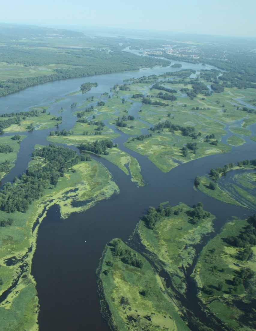
19 Table 1-2 Evolution of EMP s programmatic elements Habitat Projects WRDA 1986 Authorization $13 million/year WRDA 1999 Authorization $22.75 million/year Long Term Resource Monitoring Computerized Inventory and Analysis Recreation Projects Study of Economic Impacts of Recreation Traffic Monitoring Independent Technical Advisory Committee $5.08 million/year $875,000/year $500,000/year (Not pursued after initial $9,000 for planning in 1986.) $750,000 over three years (Study completed in 1993.) Such sums as may be necessary. N/A Authority for long term monitoring, computerized data analysis, and applied research combined at $10.42 million/year. No changes made. Thus, the authority expired in FY Authority deleted. No changes made. While the authority remains intact, it has not been used since Instead, UMRS traffic monitoring was addressed in the 2004 Upper Mississippi River-Illinois Waterway Navigation Feasibility Study. $350,000/year through 2009 Habitat Rehabilitation and Enhancement Projects Fish and wildlife habitat on the UMRS has been declining in quantity, quality, and diversity for decades. Much of this decline is associated with human activity throughout the basin, including upland land use and development, and changes wrought by the system s 9-foot channel navigation project. While the decline is caused by a variety of factors, some of which EMP cannot address, HREPs are seeking to improve the river s floodplain structure and function to counteract the effects of an aging impounded river system. For example, HREPs may alter sediment transport and deposition, water levels, or the connections between the river and its floodplain. These types of physical changes also influence water quality parameters such as temperature, dissolved oxygen, and distribution of suspended sediments. These physical and chemical changes then combine to improve fish and wildlife habitat. EMP s planning approach and restoration techniques have served as models, both nationally and internationally, for other river restoration efforts. To accomplish their habitat management and restoration objectives, HREPs employ a variety of techniques: backwater dredging, water level management, island creation, shoreline protection, secondary channel modification, and aeration. Many projects combine these measures to address more than one problem. In addition, some projects also include innovative features or features that provide secondary benefits or complement the primary techniques. Examples include hillside sediment control, land acquisition, and notched wing dams. HREPs may also be constructed in conjunction with other programs, including the Corps channel maintenance work, to take advantage of synergies. The range of project techniques that have been used, or are being considered for possible future use, as part of HREPs is extensive (see Table 1-3 on next page). EMP authorizing legislation requires that a non-federal sponsor share the construction cost of habitat projects, unless the project is located on lands managed as a national wildlife refuge. 3 In particular, the Corps provides 65 percent of the funding for nonrefuge projects and the non-federal sponsor, typically a state agency, funds 35 percent. Projects that are located on lands managed as a national wildlife refuge are 100 percent federally funded through the Corps EMP appropriations. 3 Section 906(e) of the Water Resources Development Act governs cost sharing for EMP habitat projects. In addition to projects on lands managed as national wildlife refuges, Section 906(e) also authorizes 100 percent federal construction funding for projects that benefit federally-listed threatened or endangered species, species of national economic importance, species subject to international treaties, and anadromous fish. However, as a matter of Administration policy, 100 percent federal funding for HREPs has been limited to refuge lands. 9

20 Table 1-3 EMP HREP techniques Technique Dredge backwaters Manage water levels using dikes and water control structures Build islands Protect shorelines Modify secondary channels and river training structures Water aeration Objectives Alter flow patterns and velocity Improve floodplain structural diversity Increase deep water fish habitat for overwintering Provide access for fish movement Provide dredged material to support revegetation and island building Restore more natural hydrologic cycles in project area Promote growth of aquatic plants as food for waterfowl Reduce backwater sediment loads Consolidate bottom sediments Control rough fish Decrease wind and wave action Alter flow patterns and sediment transport Improve aquatic plant growth Improve floodplain structural diversity Provide nesting and loafing habitat for waterfowl and turtles Restore woody vegetation Prevent shoreline erosion Maintain floodplain structural diversity Create fish habitat Reduce sediment loads to backwaters Create barriers to waves and currents Improve fish habitat and water quality by altering inflows and diversifying substrate thickness Stabilize eroding channels Reduce sediment load to backwaters by reducing flow velocities Maintain water temperature and provided rock substrate Improve habitat and water quality by introducing oxygenated water Miscellaneous Experimental and Complementary Techniques Seed island Upland sediment control Land acquisition Riffle pools Potholes Notched wing dams Anchor tree clumps Isolated wetlands Weirs Rock sills Sediment traps Mussel substrates Bottomland forest restoration Vegetative plantings 10
21 In accordance with Section 107(b) of WRDA 1992, operation and maintenance (O&M) of HREPs is the responsibility of the agency that manages the land, typically the U.S. Fish and Wildlife Service or a state natural resource agency. In addition, each completed project is monitored to determine whether the anticipated physical and chemical responses, such as changes in flow or water quality, are occurring. A limited number of projects are also selected for intensive monitoring of biological response, such as plant growth or changes in fish populations. Though EMP does not monitor public use of project areas, anecdotal information and data from partners suggest that public response to projects is very favorable. The process of identifying, planning, and prioritizing HREPs is an interagency and public endeavor involving the Corps, U.S. Fish and Wildlife Service, U.S. Environmental Protection Agency, the five state natural resource and water quality agencies, nongovernmental organizations, and individuals. In collaboration with the newly authorized NESP, projects are selected for planning based on their potential to address identified ecosystem objectives. The projects are then jointly planned by interdisciplinary teams of partner agencies within each of the three UMR Corps Districts, with input from the interested public. That project formulation process uses both qualitative and quantitative tools to identify the most cost-effective combination of features to meet project goals. The process used to determine priority projects to advance to engineering, design, and construction includes ecological, as well as administrative and policy, considerations. Such considerations include, among other things, timing of planning and construction activities, geographic distribution, and funding availability. Long Term Resource Monitoring Program EMP LTRMP was authorized to provide standardized collection, integration, analysis, research, and reporting of scientific information to support management of the UMRS. In particular, as articulated by EMP s partnership of state and federal agencies, the goals of LTRMP are to: develop a better understanding of the Upper Mississippi River ecosystem and its problems; monitor and evaluate long term resource changes and trends; develop alternatives to better manage the river system; and manage, organize, and distribute scientific information about the river. While the Corps has overall responsibility and oversight for LTRMP, the U.S. Geological Survey, through its Upper Midwest Environmental Sciences Center, has lead responsibility for executing the program. Monitoring is conducted from six stateoperated field stations, located on the Upper Mississippi River in Pool 4 (Lake City, Minnesota), Pool 8 (La Crosse, Wisconsin), Pool 13 (Bellevue, Iowa), Pool 26 (Great Rivers; Alton, Illinois), and the Open River reach (Open River; Cape Girardeau, Missouri), as well as the La Grange Pool of the Illinois River (Havana, Illinois). (See Figure 1-1 on next page.) Personnel at these field stations collect data on fish, aquatic vegetation, and water quality. EMP eliminated a macroinvertebrate (e.g., zebra mussels, fingernail clams, and mayflies) component in 2005 because of funding constraints. In addition, LTRMP scientists assemble and evaluate data related to water depth (i.e., bathymetry), topography, hydrology, sediment, land use and land cover, birds, and exotic species. 4 These data sets and the stateof-the-art Geographic Information System (GIS) used to interpret spatial data enable LTRMP scientists to document system-wide ecological trends and investigate specific resource problems, such as the impacts of navigation, sedimentation, artificially high and stable water levels, water level fluctuation, lack of aquatic vegetation, invasive species, and reduced native fish populations. EMP Implementation The Partnership As the federal agency authorized to implement EMP, the Corps is accountable for management and execution of the program. As a result, EMP has been shaped in many ways by Corps policies and procedures. Yet EMP is truly a partnership program. This fact can be traced not only to EMP s origins with the Upper Mississippi River Basin Commission, but also to EMP s 1986 authorizing legislation, which directs the Corps to implement EMP in consultation with the Department of the Interior and the five basin states. The region has a rich tradition of interagency partnership that EMP has been fortunate to be able to build upon and nourish. For the specific purpose of providing interagency coordination for EMP, the Corps established the EMP Coordinating Committee (EMP-CC) in 1987 to ensure the Congressionally directed consultation with state and federal partners. The EMP-CC is the primary consultative body used to discuss and seek consensus on EMP budgetary and policy issues. The Corps and the U.S. Fish and Wildlife Service co-chair the EMP-CC. Membership consists of representatives from the U.S. Geological Survey, each of the five state resource agencies, and a variety of federal agencies 5 that have an interest in EMP, even though they have no specific implementation responsibilities. 4 LTRMP s data sets and syntheses are available at 5 The U.S. Environmental Protection Agency, U.S. Department of Agriculture (Natural Resources Conservation Service), and U.S. Department of Transportation (Maritime Administration) have been asked to serve as additional federal members of the EMP-CC. Only U.S. EPA is currently an active member of the EMP-CC. 11
22 12 Figure 1-1 Long Term Resource Monitoring Program Field Stations

23 To provide more detailed scientific guidance on LTRMP implementation, another interagency committee called the Analysis Team, or A-Team, was formed. This team provides science and technical advice and recommendations on LTRMP work priorities, annual work plans, and research activities. The team is comprised of biologists and other technical staff from federal and state agencies. The planning and prioritization of habitat projects is guided by interagency teams in each of the three Corps Districts. These teams include the River Resources Forum (St. Paul District), the River Resources Coordination Team (Rock Island District), and the River Resources Action Team (St. Louis District). Project planning on the Illinois River is also coordinated with the Illinois River Coordinating Council. These interagency district-based teams also provide critical links to other river management activities. EMP authorizing legislation designates the Upper Mississippi River Basin Association 6 as the caretaker of the Master Plan. As such, major EMP policy and budgetary issues are often addressed in this forum; and the Association has a longstanding commitment to the program s successful implementation. The public participates in EMP through the involvement of local governments; sport, conservation, and industry nongovernmental organizations; and individual participation. The public was very engaged in the original EMP authorization and has continued to influence the program by providing input and monitoring the implementation of both the HREP and LTRMP components. Public involvement ranges from providing comments on specific project proposals to engaging in more regional, program-level matters coming before the EMP-CC. Roles and Responsibilities In addition to the various interagency consultative and coordination bodies associated with EMP, individual federal and state agencies have their own specific responsibilities under EMP. U.S. Army Corps of Engineers The Mississippi Valley Division (MVD) has overall responsibility for EMP and has assigned many of the program management responsibilities to the Rock Island District. USACE divides EMP s annual HREP allocation among the St. Paul, Rock Island, and St. Louis Districts based on the number of river miles within each District. Within their respective boundaries, the Districts are then responsible for identifying priority actions and leading the planning, design, construction, and evaluation of habitat projects within their jurisdictions. Regionally, the Rock Island District provides overall leadership for EMP and coordinates activities within the three UMR districts; among state and federal agency partners and other stakeholders; and with the public. The District also coordinates with MVD and Corps Headquarters on policy- and budget-related matters. Rock Island District oversees and integrates the HREP and LTRMP components of EMP; operates partner-based forums, such as the Environmental Management Program Coordinating Committee (EMP-CC) and LTRMP Analysis Team; prepares budget submissions; recommends annual appropriations allocations within EMP; and develops scientific reports. U.S. Fish and Wildlife Service Region 3 of the Service, which encompasses the entire UMRS, coordinates the involvement of Service personnel from the refuges, ecological services field offices, and fisheries resource offices. All of these Service offices participate in the planning, design, and construction of HREPs, both on and off refuge lands. The Service is responsible for operation and maintenance of projects on lands it manages, and participates in pre- and postproject monitoring. The Corps, in compliance with the Fish and Wildlife Coordination Act and Endangered Species Act, consults with the Service for planning and implementation of habitat projects. Through this consultation process, the Service helps to identify potential biological responses from proposed projects. U.S. Geological Survey The U.S. Geological Survey (USGS) provides science leadership and daily administration of the LTRMP component through its Upper Midwest Environmental Sciences Center in La Crosse, Wisconsin. This includes program planning, coordination, and administration, as well as executing important work in the areas of research, data analysis, modeling and decision support, and data maintenance and access. In serving these roles, USGS coordinates closely with the Corps of Engineers, state field stations, and interagency coordination bodies. States Resource agencies in each of the five UMR states 7 are actively involved in implementing HREPs in their jurisdiction and in adjacent states. These agencies participate on the St. Paul, Rock Island, and St. Louis District planning and design teams, the A-Team, and the EMP-CC. The states may serve as nonfederal sponsors, providing 35 percent of the total construction costs for projects not on lands managed for national wildlife refuge purposes. The states are responsible for 100 percent of the operation and maintenance of projects on lands that they manage, and are actively engaged in pre- and post-project 6 The Upper Mississippi River Basin Association is a regional interstate organization formed in 1981 by the Governors of Illinois, Iowa, Minnesota, Missouri, and Wisconsin to coordinate the states river-related programs and policies and work with federal agencies that have river responsibilities. 7 These agencies are the Illinois Department of Natural Resources, Iowa Department of Natural Resources, Minnesota Department of Natural Resources, Missouri Department of Conservation, and Wisconsin Department of Natural Resources. 13

24 monitoring of habitat projects. In addition, LTRMP field stations, which implement the monitoring programs, are staffed and operated by state employees, with funding transferred from the Corps to the states through the USGS. State agencies also contribute in a variety of ways to LTRMP s design and execution. Others Many other federal and state environmental protection, agriculture, and transportation agencies are also involved in EMP s implementation. These include, but are not limited to, U.S. Environmental Protection Agency, Natural Resources Conservation Agency, and state water quality programs. These agencies and programs contribute their staff expertise to assist in EMP s habitat restoration and scientific monitoring and research efforts by providing valuable information and insights. EMP s coordinating mechanisms effectively allow for such transfer of knowledge and cross-programmatic collaboration, substantially enhancing overall efforts to ensure the sustainability of the multiple-use river system. Funding WRDA 1999 authorized annual appropriations of $22.75 million for HREPs; $10.42 million for LTRMP; and $350,000, through 2009, for an independent technical advisory committee. Prior to the 1999 reauthorization, the annual legislative authorization for HREPs was $13.0 million and for LTRMP was $5.955 million. Prior to 1999, there was no authority for an independent technical advisory committee. While funding for each EMP component is individually authorized, Congress appropriates funds for EMP as a single line item. From that annual program appropriation, funds are allocated for overall program management costs, as well as the two major program components i.e., HREPs and LTRMP. With appropriations lower than authorized levels, EMP s authorization directed EMP to allocate 68.6 percent and 31.4 percent of its appropriation to the HREP and LTRMP components, respectively. However, Congress also allows EMP the flexibility to transfer up to 10 percent of the annual appropriation between components. This helps the Corps to achieve the Congressionally-directed allocation formula. 14
; (see Figure 1-2 below). The annual appropriation averaged $21.")

25 From EMP s inception through FY 2010, Congress has appropriated a total of $391.1 million. Over that same period, the legislative authorization totaled $585.0 million. During those 24 years, the full amount of the annual legislative authorization was provided in five years (FY ); (see Figure 1-2 below). The annual appropriation averaged $ million between FY 2004 and FY 2010, ranging from a low of $ million to a high of $ million. In FY 2009, additional funding from the American Recovery and Reinvestment Act combined with regular appropriations to give EMP its highest obligation authority ever, $ million. The additional funding increased EMP s capabilities substantially, allowing the program to expedite critical habitat restoration and research priorities. Table 1-4 (see next page) summarizes how funds have been allocated over time. The dollar amounts listed below in Figure 1-2 and in Table 1-4 on the next page differ slightly because of savings and slippage 8 applied to Corps appropriations in earlier years. In administering EMP, the Corps transfers funding to USGS to carry out LTRMP. This typically amounts to about one-third of EMP s budget. A portion of those funds is then provided to the states to support the work of the six field stations. The Corps also transfers funding to the U.S. Fish and Wildlife Service to support its involvement in the planning, design, and monitoring of HREPs. While appropriations to the Corps of Engineers fund the largest portion of EMP costs, that amount does not fully reflect the investment that has been made. The U.S. Fish and Wildlife Service is responsible for the costs of operating and maintaining HREPs on lands that it manages. Between FY 2004 and 2009, the U.S. Fish and Wildlife Service s estimated total cost for operating and maintaining HREPs was more than $2.5 million. Figure 1-2 EMP funding history (appropriated vs. authorized) 8 Savings and slippage reduces non-earmarked programs and projects within the Corps major accounts by a fixed percentage. It has been used in the past as a tool when Congress appropriated less total funding for an account than the sum of the individual program/project line items within that account. Historically, the Administration sometimes also increased the savings and slippage reduction by an additional amount and retained the authority to reprogram these funds to specific programs/projects with demonstrated need and capability. 15

26 The five basin states have also made substantial investment in EMP. Since its inception, the states have spent approximately $19.4 million in support of EMP. This includes non-federal cost share for HREPs on non-refuge lands, operation and maintenance of the habitat projects on lands the states manage, and various efforts to support states involvement in planning, coordinating, and implementing all components of the EMP. Of this amount, about $2.9 million was expended since the 2004 Report to Congress. Table 1-4 EMP funding allocations ($1,000) Habitat Projects Long Term Resource Monitoring Other Elements b Program Management FY FY 04 FY 05 FY 06 FY 07 FY 08 a FY 09 a FY 10 a Total 145,450 9,470 10,015 13,627 14,666 85,207 4,522 4,744 5,212 6, , ,408 23,032 10,084 $241,752 5,393 8,792 5,904 $126,125 $965 1,050 1, $22,082 Total $247,038 $14,782 $15,547 $19,800 $21,894 $21,851 $33,142 $16,870 $390,924 a b The total annual amounts reflect saving and slippage and rescissions, but do not include carry-over from previous fiscal years. FY 08 includes a flood damage appropriation of $5 million. FY 09 includes a flood damage appropriation of $2 million and an additional stimulus appropriation of $ million ($ million for habitat projects and $2.800 million for LTRMP). FY 10 includes $400,000 in stimulus funds for LTRMP. Includes recreation projects, study of the economic impacts of recreation, and traffic monitoring. 16
, EMP has made vital contributions to improving the health of the river s ecosystem.")
27 Chapter 2 Highlights and Accomplishments Overview Since its authorization in 1986, EMP has established a record of significant accomplishment. Through Habitat Rehabilitation and Enhancement Projects (HREPs), EMP has made vital contributions to improving the health of the river s ecosystem. The Long Term Resource Monitoring Program (LTRMP) has substantially enhanced our understanding of the UMRS, as well as large floodplain river systems in general. In response to Congress directive in the Water Resources Development Act (WRDA) of 1999, this chapter highlights many of EMP s most significant accomplishments, with a particular focus on achievements since completion of the previous Report to Congress in Habitat Rehabilitation and Enhancement Projects As described in Chapter 1, EMP s HREP component addresses a longstanding trend toward declining fish and wildlife habitat on the UMRS. Combining various techniques, HREPs are designed to modify the river s floodplain structure and function to counteract the effects of an aging, impounded river system. HREPs are frequently multi-faceted, allowing a single project to benefit many types of habitat. For example, dredging backwaters may serve a primary project purpose of creating deepwater aquatic habitat, while having the added benefit of providing fill material needed to construct islands that are also part of the project design. Such projects improve a variety of habitat types, including submersed aquatic plant, marsh, grassland, and forest habitats. The responses occur in secondary channel, backwater, or impounded aquatic areas, and in adjacent floodplain areas. Submersed and emergent marsh plants are common restoration targets in aquatic areas. Bottomland forests and grasslands are frequent terrestrial targets. Many marsh communities respond naturally to improved water quality or hydraulic conditions. Plantings on terrestrial areas improve tree species and habitat diversity. Table 2-1 (see pages 18-20) illustrates the variety and complexity of individual HREPs, and also shows where on the river system EMP has addressed various habitat types. Project designs address specific ecological goals and objectives through a comprehensive planning process. During project planning, EMP considers hydraulic and ecological processes to create cost-effective, sustainable outcomes. Some project areas are deliberately isolated and managed independently from the river to restore critical ecological functions, primarily hydrologic variation and more natural sedimentation patterns, in a cost-effective way that is consistent with the Corps navigation mission. Projects completed since EMP s inception have produced significant habitat improvements, and are also contributing to the refinement of current restoration efforts. EMP s ecosystem restoration planning approach has been a key factor in the success of the program. It is a planning process that encourages stakeholder involvement to ensure the selection of sound and acceptable projects. Other Corps Districts and resource agencies have used EMP s planning process and restoration techniques as a model. Habitat planners from Central and South America, Europe, Africa, and Asia have visited the UMRS to learn from EMP s experiences. Several elements of the HREP s administration are largely unchanged since they were described in the 1997 Report to Congress and continue to function quite well. These include established protocols for monitoring the physical, chemical, and biological impacts of projects and a longstanding practice of holding interagency reviews to exchange important information on project design, construction techniques, contracting issues, and related matters. These practices were detailed in the 1997 Report to Congress, and thus will not be addressed here. Instead, this section will focus on new information, including describing the cumulative impact of the projects completed, what has been learned about particular project techniques, and efforts to implement a more systemic and comprehensive planning approach. 17
 - Finished (F), Under Construction (C), or in Design (D)] Note: These habitat types are aggregated from the 2000 Upper Mississippi River Habitat Needs Assessment Summary Report. Project Dist. Stat.")


28 Table 2-1 Habitat types addressed in individual EMP HREPs [Districts (Dist.) - St. Paul (MVP), Rock Island (MVR), or St. Louis (MVS); Status (Stat.) - Finished (F), Under Construction (C), or in Design (D)] Note: These habitat types are aggregated from the 2000 Upper Mississippi River Habitat Needs Assessment Summary Report. Project Dist. Stat. Wet Isolated Prairie/Forest a Sand/Mud Wetlands Channels b Contiguous Backwater Lakes and Marshes Aquatic Vegetation c Ambrough Slough, WI MVP F X X Andalusia Refuge, IL MVR F X X X X Banner Marsh, IL MVR F X X X Bass Ponds, Marsh, and Wetland, MN MVP D X X X X Batchtown, IL MVS C X X X X X X X Bay Island, MO MVR F X X X Beaver Island, IA MVR D X X X X X X X Bertom McCartney Lakes, WI MVR F X X X X X X Big Timber, IA MVR F X X X X X Blackhawk Park, WI MVP F X X Boston Bay, IL MVR D X Brown s Lake, IA MVR F X X X X X Bussey Lake, IA MVP F X X X X X X Calhoun Point, IL MVS C X X X Capoli Slough, WI MVP D X X X X X X Chautauqua Refuge, IL MVR F X X X Clarence Cannon, MO MVS D X X X X X Clarksville Refuge, MO MVS F X X X Clear Lake, MN MVP D X Cold Springs, WI MVP F X Conway Lake, IA MVP D X X X X X X Cottonwood Island, MO MVR F X X X X Cuivre Island, MO MVS F X X X X X Delair Division, IL MVR D X X X Dresser Island, MO MVS F X X X X East Channel, WI, MN MVP F X Finger Lakes, MN MVP F X Fox Island, MO MVR D X X Ft. Chartres Side Channel, MO MVS D X X X X Glades Wetland Complex, IL MVS D X X X X Godar Refuge, IL MVS D X X X X Guttenberg Waterfowl Ponds, IA MVP F X X X Harlow Island, MO MVS D X X X X Harpers Slough, IA, WI MVP D X X X X X X Huron Island, IA MVR D X X X X Indian Slough, WI MVP F X X X Island 42, MN MVP F X X Other 18
29 Table 2-1 Habitat types addressed in individual EMP HREPs (continued) [Districts (Dist.) - St. Paul (MVP), Rock Island (MVR), or St. Louis (MVS); Status (Stat.) - Finished (F), Under Construction (C), or in Design (D)] Note: These habitat types are aggregated from the 2000 Upper Mississippi River Habitat Needs Assessment Summary Report. Project Dist. Stat. Wet Isolated Prairie/Forest a Sand/Mud Wetlands Channels b Contiguous Backwater Lakes and Marshes Aquatic Vegetation c Keithsburg Division, IL MVR D X X X X Lake Odessa, IA MVR F X X X X Lake Onalaska, WI MVP F X X X Lake Winneshiek, WI MVP D X X X X X X Lansing Big Lake, IA MVP F X X Lock & Dam 3 Fish Passage, WI MVP D X Long Island Division, IL MVR F X X X Long Lake, WI MVP F X Long Meadow Lake, MN MVP F X X X X Lower Pool 10 Island and Backwater Complex, IA MVP D X X X X X McGregor, WI MVP D X X X X Mississippi Bank Stabilization, IA, MN, WI MVP F X X X X Monkey Chute, MO MVR F X North and Sturgeon Lakes, MN MVP D X X X X Peoria Lake, IL MVR F X X X X X Peterson Lake, MN MVP F X X X Pharrs Island, MO MVS F X X X X Piasa and Eagles Nest Islands, IL MVS D X X X X X Pleasant Creek, IA MVR F X X Polander Lake, MN MVP F X X X X X Pool 11 Islands-Sunfish Lake, IA, WI MVR F X X X X X Pool 11 Islands- Mud Lake, IA, WI MVR F X X X X Pool 12 Overwintering, IA, IL MVR D X X Pool 24 Islands, MO MVS D X X X Pool 25 and 26 Islands, MO MVS C X X X Pool 8 Islands Phase I, WI MVP F X X X Pool 8 Islands Phase II,WI MVP F X X X X X Pool 8 Islands Phase III, WI MVP F X X X X X X Pool 9 Islands, WI MVP F X X Pool Slough, IA, MN MVP F X X X Potters Marsh, IL MVR F X X X Princeton Refuge, IA MVR F X X X X X X Red s Landing Wetlands, IL MVS D X X X X Rice Lake, MN MVP F X X X Other 19
 - Finished (F), Under Construction (C), or in Design (D)] Note: These habitat types are aggregated from the 2000 Upper Mississippi River Habitat Needs Assessment Summary Report. Project Dist. Stat.")
30 Table 2-1 Habitat types addressed in individual EMP HREPs (continued) [Districts (Dist.) - St. Paul (MVP), Rock Island (MVR), or St. Louis (MVS); Status (Stat.) - Finished (F), Under Construction (C), or in Design (D)] Note: These habitat types are aggregated from the 2000 Upper Mississippi River Habitat Needs Assessment Summary Report. Project Dist. Stat. Wet Isolated Prairie/Forest a Sand/Mud Wetlands Channels b Contiguous Backwater Lakes and Marshes Aquatic Vegetation c Rice Lake, IL MVR D X X X Rip Rap Landing, IL MVS D X X X X Small Scale Drawdown, WI MVP F X Snyder Slough Backwater Complex, WI MVR D X X X X X X X Spring Lake Islands, WI MVP F X X X X X Spring Lake Peninsula, WI MVP F X X X X Spring Lake, IL MVR F X X Stag and Keaton Islands, MO MVS F X X Steamboat Island, IA MVR D X X X Stump Lake, IL MVS F X X X Swan Lake, IL MVS C X X X X Ted Shanks, MO MVS D X X X X X Trempealeau, WI MVP F X X Turkey River Bottoms Delta and Backwater, IA, WI MVR D X X X X X Weaver Bottoms, MN MVP D X X X X X X West Alton Tract, MO MVS D X X X Wilkinson Island, IL MVS D X X X X X a Wet prairie/forest includes wet meadow, grassland, scrub/shrub, salix community, populus community, wet floodplain forest, and mesic bottomland hardwood forest. b Channels include main channel and secondary channel. c Aquatic vegetation includes submersed aquatic bed, floating-leaved aquatic bed, semi-permanently flooded emergent annual, semi-permanently flooded emergent perennial, seasonally flooded emergent annual, and seasonally flooded emergent perennial. Other 20
.")
31 Accomplishments and Outcomes EMP s 2004 Report to Congress reported 40 projects affecting 67,000 acres of habitat. Since then, 13 additional HREPs have been constructed, affecting more than 28,100 acres of aquatic and floodplain habitat (see Table 2-2 on pages and Figure 2-1 on pages 26-27). The total area of improved river habitat is approximately 95,100 acres, distributed among the 53 completed projects. The Corps uses cost per acre of habitat restored as a measure of restoration efficiency. Even though EMP s projects must function in a highly energetic environment, EMP s average cost per acre of habitat restored is less than $3,000, which is considerably lower than that of many comparable programs. As of October 2010, EMP had five projects under active construction, 1 which will improve 19,980 acres, and 35 projects still in various stages of planning and design that will benefit another 77,550 acres of fish and wildlife habitat. When these are all completed, the total area of improved habitat will be about 175,000 acres among the 88 projects. While these projects will improve habitat conditions on about seven percent of the total UMRS floodplain area, they represent only a small fraction of the restoration needs documented in the 2000 Habitat Needs Assessment 2 and other planning efforts. Highlights and Lessons Learned Environmental Design Handbook In August 2006, the Corps, with input from EMP partners, completed the Environmental Design Handbook to document EMP s array of restoration tools and lessons learned to inform future HREPs. These restoration tools include shoreline protection, island creation, water level management, backwater dredging, secondary channel modifications and river training structures, aeration, and floodplain and tributary restoration. 3 Table 2-2 shows where EMP has implemented these techniques. Among all of the completed habitat projects, EMP has implemented these techniques relatively evenly (see Figure 2-2 on page 28). The Handbook details the project features, design methodologies, and lessons learned since EMP s inception. The Corps plans to periodically update the Handbook to capture new information about how innovative restoration tools can enhance the UMRS. Shoreline Protection Natural and constructed shorelines are subject to erosive currents and wave and ice action in many locations on the river, including the main channel and backwaters. This erosion can threaten the longevity of habitat projects, as well as degrade existing fish and wildlife habitat. Unabated, it can result in the loss of islands and increased erosive forces in backwaters. Techniques to protect shorelines include traditional bank stabilization measures, such as stone riprap, and innovative approaches, such as vegetation, rock groins, and offshore structures. Protecting shorelines will maintain floodplain structural diversity, increase and enhance fish habitat, reduce sediment loads, and create barriers to waves and currents. Over the years, EMP has refined its tools to protect shorelines, enhancing projects natural appearance while lowering construction costs. Example design improvements include increased gradient diversity and more gradual slopes offering better fish, turtle, and bird habitat; off-shore rock mounds to dissipate wave energy; sacrificial sand berms and groins for shorebird habitat; and rock-log structures in areas with minimal ice impacts, as a lower cost alternative to offshore rock mounds. Islands Prior to impoundment, the UMRS had a braided island form along much of its length. Many of those islands were inundated when the lock and dam system was established, and others were lost subsequently to increased wind-wave erosion, boat-wave erosion, currents, and ice impacts. The loss of these islands and substantial reduction in vegetation from impoundment significantly degraded fish and wildlife habitat, particularly in the lower portion of each pool. But EMP has been very successful in constructing islands that provide high quality habitat for a wide range of fish and wildlife and that partially restore the river s natural hydrodynamic, sediment transport, and geomorphic conditions. EMP has improved island designs by incorporating lessons learned from significant flooding events. Observations of completed projects indicate that relatively flat, vegetated islands are stable during flood events, and that increased scouring and deposition around created islands enhance aquatic habitat diversity. EMP also uses two-dimensional hydrodynamic and wind fetch models to determine the best placement and layout of islands, thus maximizing their potential benefits. 1 Four of these projects that are currently under active construction will not require additional funding, and therefore are considered finished. (See Table 2-2). 2 The 2000 Habitat Need Assessment is available at 3 The EMP Environmental Design Handbook is available at 21
 - Finished (F), Under Construction (C), or in Design (D); Percent Complete (%)] Project Dist. Stat.")
32 22 Table 2-2 EMP HREP status, as of October 2010 [Districts (Dist.) - St. Paul (MVP), Rock Island (MVR), or St. Louis (MVS); Status (Stat.) - Finished (F), Under Construction (C), or in Design (D); Percent Complete (%)] Project Dist. Stat. % Acres Affected Shoreline Protection Island Creation Water Level Management Backwater Dredging Secondary Channel Modifications Aeration Other a Ambrough Slough, WI MVP F 100 2,920 X X X X X Andalusia Refuge, IL MVR F X X X X Banner Marsh, IL MVR F 100 4,290 X X Bass Ponds, Marsh, MVP D X X X X and Wetland, MN Batchtown, IL MVS C 85 3,280 X X Bay Island, MO MVR F X X Beaver Island, IA MVR D 3 1,750 X X X Bertom McCartney Lakes, WI MVR F 100 2,340 X X X X X Big Timber, IA MVR F 100 1,240 X X Blackhawk Park, WI MVP F X X Boston Bay, IL MVR D X X X X Brown s Lake, IA MVR F 100 1,120 X X X Bussey Lake, IA MVP F 100 1,680 X X X X Calhoun Point, IL b MVS F 97 2,140 X X Capoli Slough, WI MVP D X X X X X Chautauqua Refuge, IL MVR F 100 3,940 X Clarence Cannon, MO MVS D 1 3,590 X X X Clarksville Refuge, MO MVS F X Clear Lake, MN MVP F X Cold Springs, WI MVP F X X Conway Lake, IA MVP D 2 1,110 X X X X X X X Cottonwood Island, MO MVR F X X Cuivre Island, MO MVS F 100 2,180 X X X Delair Division, IL MVR D 1 2,080 X X X Dresser Island, MO MVS F 100 1,030 X X East Channel, WI, MN MVP F X Finger Lakes, MN MVP F X X Fox Island, MO MVR D 48 2,030 X X Ft. Chartres Side Channel, MO MVS D 7 60 X Glades Wetland Complex, IL MVS D X X X Godar Refuge, IL MVS D X X X Guttenberg Waterfowl Ponds, IA MVP F X X
33 Table 2-2 EMP HREP status, as of October 2010 (continued) Project Dist. Stat. % Acres Affected Shoreline Protection Island Creation Water Level Management Backwater Dredging Secondary Channel Modifications Aeration Other a Harlow Island, MO MVS D 1 1,300 X X Harpers Slough, IA, WI MVP D 5 1,880 X X X X X Huron Island, IA MVR D 11 2,670 X X X Indian Slough, WI MVP F X X X X Island 42, MN MVP F X X X Keithsburg Division, IL MVR D 1 1,390 X X X Lake Odessa, IA b MVR F 90 6,320 X X X X X Lake Onalaska, WI MVP F 100 2,750 X X X Lake Winneshiek, WI MVP D 8 5,170 X X X X X Lansing Big Lake, IA MVP F 100 6,420 X Lock & Dam 3 Fish Passage, WI MVP D X Long Island Division, IL MVR F 100 6,090 X X X Long Lake, WI MVP F X X Long Meadow Lake, MN MVP F 100 2,340 X X Lower Pool 10 Island and Backwater Complex, IA MVP D 1 2,000 X X X X X McGregor, WI MVP D 1 1,000 X X X Mississippi Bank Stabilization, IA, MN, WI MVP F 100 1,300 X Monkey Chute, MO MVR F X North and Sturgeon Lakes, MN MVP D 1 4,600 X X X X Peoria Lake, IL MVR F 100 2,500 X X X Peterson Lake, MN MVP F X X X X Pharrs Island, MO MVS F X Piasa and Eagles Nest Islands, IL MVS D X X X Pleasant Creek, IA MVR F X Polander Lake, MN MVP F X X X X Pool 11 Islands- Sunfish Lake, IA, WI MVR F 100 4,000 X X X X X X Pool 11 Islands-Mud Lake, IA, WI MVR F 100 4,550 X X X X X X Pool 12 Overwintering, IA, IL MVR D 23 7,990 X X Pool 24 Islands, MO MVS D 1 3,150 X X X Pool 25 and 26 Islands, MO MVS D 34 4,020 X X X Pool 8 Islands Phase I, WI b MVP F 100 1,000 X X X 23

34 Table 2-2 EMP HREP status, as of October 2010 (continued) Project Dist. Stat. % Acres Affected Shoreline Protection Island Creation Water Level Management Backwater Dredging Secondary Channel Modifications Aeration Other a Pool 8 Islands Phase II, WI, MN MVP F X X X X Pool 8 Islands Phase III, WI b MVP F 80 3,320 X X X X X Pool 9 Islands, WI MVP F X Pool Slough, IA, MN MVP F X Potters Marsh, IL MVR F 100 1,200 X X X X Princeton Refuge, IA MVR F 100 1,080 X X Red s Landing Wetlands, IL MVS D 1 1,620 X X X X Rice Lake, MN MVP F X X X Rice Lake, IL MVR D 27 6,350 X X Rip Rap Landing, IL MVS D 6 1,810 X X Small Scale Drawdown, WI MVP F X Snyder Slough Backwater Complex, WI MVR D 1 4,280 X X X X X Spring Lake Islands, WI MVP F X X X X X Spring Lake Peninsula, WI MVP F X X X X Spring Lake, IL MVR F 100 3,610 X X Stag and Keaton Islands, MO MVS F X Steamboat Island, IA MVR D 1 1,280 X X X Stump Lake, IL MVS F 100 3,170 X Swan Lake, IL b MVS F 98 4,920 X X Ted Shanks, MO MVS D 8 3,330 X X Trempealeau, WI MVP F 100 5,900 X X Turkey River Bottoms Delta and Backwater, IA, WI MVR D 1 3,150 X X X X Weaver Bottoms, MN MVP D 1 4,880 X X X West Alton Tract, MO MVS D X X X X Wilkinson Island, IL MVS D X X X X Project Summary Completed Projects (53) 95,100 Projects Under Construction (1) 3,280 Projects in Design (34) 77,530 Total (88) 175,910 a This category includes floodplain and tributary restoration and other newer and complementary restoration techniques. b These projects will not require funding in future fiscal years and therefore are categorized as finished. 24
35 Water Level Management Much of the flora and fauna native to the UMRS is adapted to the wide variation in water levels that characterized the river prior to construction of the lock and dam system. Since the implementation of the 9-foot channel navigation project, however, these variations have been truncated, with the low river stage portion of the hydrograph raised to support commercial navigation. This water level control, coupled with other cumulative effects, has degraded ecosystem conditions. Most notably, this degradation includes the loss of backwater depth diversity and aquatic plants in many areas. EMP, thus far, has implemented small-scale water level management features as part of 40 habitat projects. These features include moist soil units, backwater lakes, and green tree reservoirs, which are forested bottomlands that are flooded in the winter to provide waterfowl habitat. Water level management often requires levees, pumps, and other control structures that are more costly to build, maintain, and operate relative to other HREP types. However, these projects are sometimes the only reliable mechanism to counteract the impacts of impoundment and floodplain development, and thus restore valuable habitat that has been lost or significantly degraded. Over the years, EMP has enhanced its water level management techniques. For example, complete dewatering of sites reduces the potential for botulism mortality among migratory waterfowl; overflow spillways lessen the potential for levee breaches during high water events; and levees with relatively flat slopes reduce the possibility, and lessen the severity, of muskrat destruction. In addition, managers can now operate pumps remotely using telemetry, reducing management costs. Monitoring results from EMP and other programs indicate that water level management projects can be effectively operated for multiple management objectives, such as habitat for waterfowl, shorebirds, wading birds, reptiles, amphibians, and fish. For example, Lake Chautauqua on the Illinois River near Havanna, Illinois has been managed as a National Wildlife Refuge since 1936, but wetland management capabilities and habitat quality had degraded over the years. As part of the Lake Chautauqua HREP, EMP constructed features to improve water level management capabilities in the southern pool. Proper management of these new capabilities has resulted in a phenomenal wetland vegetation response, which has returned waterfowl use to the highest levels since the 1970s. Using other non-emp authorities, the Corps has also implemented periodic large-scale water level management in Pools 5, 6, 8, 24, 25, and 26, which has produced significant increases in vegetation. LTRMP data have been used to document biological responses from these pool-scale drawdowns. Backwater Dredging Backwater habitats support many fishes, waterfowl, shorebirds, and wading birds. However, high sedimentation rates have caused widespread loss of backwater and secondary channel depth and depth diversity. Loss of water depth in these areas decreases overall fish habitat quality, especially in the winter when backwaters provide refuge from harsh conditions in main channel areas. Poor water quality, contaminated sediments, and sediment resuspension also degrade habitat. Backwater dredging, which typically consists of dredging channels or deepwater areas, can reduce the effects of sedimentation and often complements other project components. Fish habitat and water quality objectives are met in most dredged channels, although some dredged habitats have filled more quickly than expected. Typically, dredging is performed in conjunction with other project features, such as island construction. For example, EMP has used dredged material to construct extensive islands in Pools 8 and 11. In some cases, islands have included designs for disposing dredged material from backwaters that eventually become valuable habitat as isolated wetlands (see Figure 2-3 on page 29). However, sometimes material dredged as part of an HREP does not have the characteristics (e.g., particle size, contaminant level, etc.) needed to construct the island or other project feature, so it is critical to understand those characteristics upfront. EMP has found that to effectively implement backwater dredging, project designs need to consider assumptions regarding dredging production rates, water quality restrictions, river characteristics in the particular location, sediment type, and design life. Secondary Channel Modifications Impoundment and other human activities in the floodplain have substantially altered the relationship between the main channel and secondary channels throughout the UMRS. In the St. Paul District, secondary channel restoration projects typically introduce flow into isolated channels or restrict flow into channels to reduce sedimentation and current velocity. Similarly, the St. Louis District is pursuing projects to open the upstream end of secondary channels, with the goal of introducing flow and improving water quality. In addition, the St. Louis District is developing innovative designs for river training structures and modifications, which primarily serve to help maintain the navigation channel, but which can also enhance the river s habitat diversity when properly designed. These structures can alter hydrodynamic conditions, sediment transport regimes, water depth diversity, and habitat conditions. While EMP s use of training structures is very limited, they offer significant future potential. 25

36 26 Figure 2-1 Distribution of EMP HREPs (Pool 8 Islands listed as three separate projects in Tables 2-1 and 2-2)

37 EMP HREP Projects Site Ref Ambrough Slough 1 Andalusia Refuge 2 Bank Stabilization 3 Banner Marsh 4 Bass Ponds, Marsh, and Wetlands 5 Batchtown Management Area 6 Bay Island 7 Beaver Island Complex 8 Bertom & McCartney Lakes 9 Big Timber 10 Blackhawk Park 11 Boston Bay 12 Brown s Lake 13 Bussey Lake 14 Calhoun Point 15 Capoli Slough 16 Chautauqua Refuge 17 Clarence Cannon 18 Clarksville Refuge 19 Clear Lake 20 Cold Springs 21 Conway Lake 22 Cottonwood Island 23 Cuivre Island 24 Delair Division 25 Dresser Island 26 East Channel 27 Finger Lakes 28 Fox Island Habitat Rehab & Enhancement Project 29 Ft. Chartres Side Channel 30 Gardner Division 31 Glades Wetland Complex 32 Godar Refuge Wetland 33 Guttenberg Waterfowl 34 Harlow Island 35 Harpers Slough 36 Huron Island 37 Indian Slough 38 Island Keithsburg Division 40 Lake Odessa 41 Lake Onalaska 42 Lake Winneshiek 43 Lansing Big Lake 44 Lock & Dam 3 45 Long Lake 46 EMP HREP Projects Site Ref Long Meadow Lake 47 Lower Pool 10 Island and Backwater Complex 48 McGregor Lake 49 Monkey Chute 50 North and Sturgeon Lakes 51 Peoria Lake 52 Peterson Lake 53 Pharrs Island 54 Piasa/Eagle s Nest Islands 55 Pleasant Creek 56 Polander Lake 57 Pool 11 Islands-Sunfish Lake 58 Pool 11 Islands-Mud Lake 59 Pool 12 Overwintering 60 Pool 24 Islands 61 Pool 25 & 26 Islands 62 Pool 8 Islands - Phase I 63 Pool 8 Islands - Phase II 64 Pool 8 Islands - Phase III 65 Pool 9 Islands 66 Pool Slough 67 Potters Marsh 68 Princeton Refuge 69 Reds Landing 70 Rice Lake-IL 71 Rice Lake-MN 72 Rip Rap Landing 73 Small Scale Drawdown 74 Snyder Slough Backwater Complex 75 Spring Lake 76 Spring Lake Islands 77 Spring Lake Peninsula 78 Stag and Keeton Islands 79 Steamboat Island 80 Stump Lake 81 Swan Lake 82 Ted Shanks Conservation 83 Trempealeau Refuge 84 Turkey River Bottoms Delta and Backwater Complex 85 Weaver Bottoms 86 West Alton Tract 87 Wilkinson Island 88 27

38 Aeration Most aquatic communities and organisms require oxygen to regulate their metabolic processes. Therefore, oxygen is one of the most important chemical substances in the water and affects the distribution of many fish species. Backwaters can become oxygen deficient under certain environmental conditions where water movement is restricted. This is particularly a problem under ice during low flow conditions. As dissolved oxygen levels decline in a backwater, the area loses its habitat value for an increasingly wide range of species. Aeration can return dissolved oxygen levels to desired ranges. EMP s two most commonly implemented aeration tools are supplemental instream aeration (i.e., adding air to a flowing stream or diverting water with higher dissolved oxygen concentrations to areas with low concentrations) and restoration of deepwater zones. Monitoring results and anecdotal evidence have shown that these tools can be very successful, significantly increasing fish diversity and abundance. Many HREPs that include water control structures use those structures to aerate stagnant habitats. In the St. Paul District, eight aeration projects have resulted in significant improvements in fish densities. Floodplain Restoration Floodplain habitats are integral components of large river ecosystems because of the seasonal flood pulse that inundates them and connects them to the river. Many riverine species of plants and animals are adapted to this flood cycle and take advantage of habitat and food resources on the floodplain. However, the UMRS floodplain has been altered in a variety of ways, including dams inundating low elevation areas in the northern reaches and agriculture and flood protection disconnecting the floodplain from the mainstem in the southern reaches. Thus, floodplain restoration techniques differ along the UMRS. In the northern reaches, restoration involves protecting some areas with islands, connecting isolated backwaters, and restoring tributary channels. In the southern reaches, restoration involves water level manipulation in management areas; wetland and habitat management in leveed areas; and conversion of agriculture land to aquatic, forest, and grassland habitats, where willing sellers exist. 4 topography, where relatively small differences in land elevation result in large differences in annual inundation and soil moisture regimes, thereby regulating plant distribution and abundance. Improving topographic diversity is essential for maintaining natural plant and animal communities and restoring the floodplain s natural sediment erosion and deposition processes. Restoring wetland and native vegetation provides valuable habitat and food sources. Tributary Restoration Tributaries greatly affect the hydrology, water quality, sediment characteristics, and physical configuration of the UMRS. Sediment loads from tributaries can significantly impact the river s ecology. EMP s 2008 Status and Trends Report, along with other work by river scientists and resource managers, has identified excessive sedimentation as one of the primary ecological problems on the UMRS. In the late 1800s and early 1900s, tributary channels were straightened, deepened, and Figure 2-2 Percent of completed HREPs that employ a particular technique (as of October 2010) Specific floodplain restoration methods include increasing topographic diversity; restoring potholes or perched wetlands; and planting native mast tree, grass, and wetland species. Floodplain diversity stems from the natural ridge and swale 28 4 The original EMP authorization did not specifically address the subject of acquiring lands and easements for habitat projects. EMP land acquisition policy established by the Corps in 1994 allows land acquisition from willing sellers, within certain limits, as a technique for habitat restoration and protection. The ability to acquire lands and easements can be an important tool in habitat restoration and protection, particularly for large-scale habitat projects in river reaches with little public land. However, thus far, EMP habitat projects have not made extensive use of the program s acquisition authority. Factors that have limited EMP s use of land acquisition include the ability and/or willingness of states to cost share, the availability of other program funding options, overall HREP funding limitations, and general lack of understanding regarding the land acquisition policy. In the future, EMP partners anticipate making more use of floodplain acquisition and easements from willing sellers, in combination with other restoration techniques.

39 Figure 2-3 Bertom McCartney Lakes created an isolated wetland using backwater dredged material that now provides valuable habitat widened in an effort to improve land drainage, lower flood stages, increase arable land, and provide shorter distances for navigation. However, this channelization has significantly increased the transport of sediments and associated contaminants from the tributaries to the UMRS floodplain and main stem, thereby impairing both habitat and water quality. Tributary restoration offers great potential as a relatively new technique on the UMRS. In particular, expanding river deltas, where tributaries enter the UMRS, could help restore certain elements of pre-impoundment conditions, while maintaining the navigation channel. Specifically, tributary restoration would allow sediment to exit the tributary channel and settle on the floodplain or delta, reducing sediment input into the main stem, and eventually, in downstream backwaters. Over time, this should create more dynamic conditions at the tributary confluence; restoring a more natural island-braided morphology, secondary channels, and wetlands. Evaluation In EMP s earlier years, HREP evaluation was primarily focused on validating the physical dimensions of project features. However, post-construction monitoring also included limited, but critical, water quality parameters, such as dissolved oxygen. Project partners undertook only very limited biological response monitoring. It was assumed that, if the project features were correctly designed and constructed, native plants and animals would colonize the newly restored areas, as a result of natural processes in the rich and complex river-floodplain environment. Since the early 1990s, post-construction monitoring and evaluation has evolved in scope and complexity as our understanding of the river system s ecology has grown. While HREP evaluations still address the physical project features, the Corps has worked with partners and project sponsors to implement much more detailed chemical and biological evaluations of completed projects. 5 As HREP tools, understanding of the river system, and modeling and monitoring capabilities expand, so will project goals and objectives and overall abilities to evaluate the direct and indirect impacts of habitat projects. This will also enhance EMP s capacity to continue applying adaptive management techniques to HREP design and operation and maintenance. Furthermore, environmental factors, including sedimentation, invasive species, and unforeseen impacts from HREPs, will continue to require a learning component to inform future project goals and associated measures to attain those goals. Lessons learned from previous evaluations also aid in improving future evaluation techniques. 5 HREP evaluations are available upon request to U.S. Army Corps of Engineers, Rock Island District. 29


40 Pool 8 Islands Phase II Prior to impoundment, major island complexes characterized much of the UMR. However, establishment of the lock and dam system inundated many islands, including those in Pool 8. This island loss resulted in more wind and wave action in the main channel, thereby increasing erosive forces on remaining islands and turbidity in backwaters. This in turn led to substantial loss and degradation of valuable fish and wildlife habitat. Figure 2-4 below illustrates the effects of impoundment and wave action on islands and EMP s ability to restore many of those islands in a time lapse series of photos of Pool 5. Pool 8 Islands Phase II created seven islands, covering 26 acres and extending over two miles along the river, and six additional seed islands, to restore fish and wildlife habitat, reduce sediment resuspension caused by wind-generated wave action, and decrease turbidity to levels that allow aquatic vegetation to reestablish (see Table 2-3 on next page). The islands are protected by rip rap and vegetation to prevent erosion. This project is the second of five phases of island construction in Pool 8; the third phase is currently under construction. Pool 8 Islands Phase II also restored 600 acres of deepwater overwintering fish habitat, which includes two rock sills to facilitate the flow of oxygenated water into the area during the winter. Figure 2-4 Islands eroded by impoundment and wave action were reconstructed in Pool 5 s Spring Lake 1930 Spring Lake 1951 Spring Lake 1991 Spring Lake Spring Lake 2004 Spring Lake 2005 Spring Lake

 and generated a positive biological response.")
41 Table 2-3 Physical conditions required to reestablish/ sustain aquatic vegetation Depth (feet) Average water velocity (mps) Water Clarity Wind Fetch Emergent Aquatics 0 2 <0.03 During growing season: Critical shear stress of sediment resuspension: Submerged Aquatics Floating Aquatics < <0.06 Secchi depth = 0.5 m OR Turbidity <20 ntu Water depth (ft) Wind fetch (ft) 1 1, , , ,000 Pre- and post-construction monitoring indicates that Pool 8 Islands Phase II has successfully reduced water velocities and wind fetch within the project area (see Figure 2-5 below) and generated a positive biological response. The vegetation response was more rapid than with previous island projects, something managers attribute to the fact that Pool 8 Islands Phase II s design addressed both water velocity and wind direction. Wisconsin Department of Natural Resources (DNR) and its LTRMP Pool 8 Field Station have documented that largemouth bass and bluegill showed a large and immediate response to the HREP (see Figure 2-6 on next page). Pool 11 Islands Similar to Pool 8, many islands in lower Pool 11 were inundated after dam construction, and the diversity of off-channel habitat has declined significantly over time. In addition, four tributary streams from agriculture-intensive basins yield high sediment loads and turbidity to this reach. The Pool 11 Islands project was constructed to reduce sediment resuspension, increase flow and water depth diversity, increase aquatic vegetation abundance and diversity, reduce backwater sedimentation, improve habitat and food resources for fish and migratory waterfowl, and reduce island erosion (see Figure 2-7 on next page). Figure 2-5 Pre- and post-modeling on Pool 8 Islands Phase II shows that the habitat project has successfully reduced wind fetch in the surrounding area Lowest Fetch Highest Fetch 31

 and Mud")
42 Figure 2-6 Largemouth bass and bluegill have responded positively to Pool 8 Islands Phase II Figure 2-7 Pool 11 Islands successfully restored fish and wildlife habitat at Sunfish Lake (left) and Mud Lake (right) 32

43 The post-monitoring results suggest a positive vegetation, fish, and waterfowl response to decreased flows and wind fetch. Although fish responded slowly to improved overwintering conditions, biologists believe fish have homing instincts and thus it often requires a successful overwintering experience to attract fish to restored areas. Preliminary monitoring results indicate that Pool 11 Islands created overwintering habitat for fish that previously lacked such habitat, thus increasing overall fish survival and abundance in Pool 11. Catch per unit effort (CPUE) and angler use also indicate an increase in fish use within the project area. Swan Lake Swan Lake is a bottomland lake and the largest backwater complex on the Illinois River, consisting of about 2,900 acres with an average depth between 3 and 3.5 feet (see Figure 2-8 on next page). Similar to other backwaters, altered hydrology for navigation and flood control and sedimentation have severely degraded Swan Lake. The bottomland hardwoods adapted for wet-dry cycles were lost with permanent inundation and prolonged flooding. Further, sedimentation in Swan Lake has significantly reduced the native vegetation and habitat quality. Through the Swan Lake HREP, EMP has sought to partially restore natural processes and ecological attributes in the area. The habitat project included a riverside levee/dike, water control/ fish passage structures, pumps, hillside sediment control basins, and service access; upgrades to an existing interior closure structure; and dredging lake sediments to construct two barrier islands (see Figure 2-9 on next page). The Corps, with monitoring data from LTRMP, USFWS, Illinois DNR, and Southern Illinois University Carbondale, analyzed the habitat project s effects on water quality, sedimentation, vegetation, aquatic macroinvertebrates, fish communities and movement, and waterfowl. Collaborative monitoring draws on the expertise from each agency to produce a thorough project performance and biological response evaluation. These results concluded that overall habitat value for waterfowl and fish was improved by substantially reducing sediment loads, providing water level control, reducing wind induced wave action and turbidity, enhancing deep water areas, and allowing for free movement of fish between the lake and river in late fall/ early winter. Ecosystem Restoration Planning Habitat Needs Assessment EMP s 1997 Report to Congress concluded that a habitat needs assessment (HNA) should be completed to establish a technically sound, consensus-based management framework for the restoration, protection, and enhancement of the UMR ecosystem. When Congress reauthorized EMP in WRDA 1999, it directed EMP to incorporate a habitat needs assessment as an ongoing program feature. In 2000, EMP completed the first HNA for the UMRS. Since the 2004 Report to Congress, EMP has continued to refine the river s habitat needs and restoration priorities. At the outset of the 2000 HNA, a coordinating committee of state and federal agency representatives outlined the following objectives for the assessment: achieve a collaborative planning process that produces technically sound and consensus based results; address a variety of habitat requirements, including physical, chemical, and biological parameters; address the unique habitat needs of distinct river reaches and pools; describe historical, existing, and projected future habitat conditions; identify objectives for future habitat conditions; define habitat needs at system, reach, and pool scales; and provide additional tools for planning future habitat protection and restoration projects. The HNA documented broad habitat protection and restoration needs. Since the assessment s completion, the HNA results have been used to inform UMRS ecosystem restoration planning efforts, particularly in identifying priority restoration opportunities. In addition to the HNA, several other ancillary planning efforts have provided information and insights valuable in refining habitat restoration needs and priorities. These include the Environmental Pool Plans for the Upper Mississippi River, Dike Alteration and Side Channel Restoration Plans for the Middle Mississippi Reach, the Middle Mississippi River Corridor Study, the Upper Mississippi River-Illinois Waterway System Navigation Feasibility Study, Comprehensive Conservation Plans for the National Wildlife Refuges, an ecosystem restoration comprehensive plan for the Illinois River Basin, the 2008 UMRS Status and Trends Report, and the UMR System and Reach Plans. Existing and Historical Conditions The 2000 HNA evaluated existing and historical habitat conditions throughout the UMRS using LTRMP s system-wide land cover and aquatic area database. These areas and habitat classes were summarized at pool, reach, and system scales to better understand what resources were present and their general distribution throughout the river system. The HNA identified clear differences in existing habitat types and conditions among river reaches, suggesting that habitat needs and thus restoration objectives vary longitudinally along the river system s length. The differences are largely related to the amount and distribution of public land, degree of floodplain development, geomorphic form of the river, and effects from river impoundment. 33


44 Figure 2-8 Swan Lake is the largest backwater complex on the Illinois River Figure 2-9 Swan Lake project features 34

45 Bottom-up, opportunistic site-specific restoration planning worked successfully in EMP s early years, when less was known about how the river functions on large reach and system scales and opportunities to address severe, site-specific degradation were abundant throughout the system. While much more work remains to restore the river to a sustainable ecosystem, our restoration tools and understandings of the river s habitat needs have advanced substantially. EMP partners are now able to effectively design and execute projects that address critical goals and priorities at system, reach, and local scales, thereby ensuring that the best river restoration projects are being implemented. Desired Future Conditions Natural resource managers and scientists involved in the 2000 HNA called for a future characterized by improved habitat quality, increased habitat diversity, and a closer approximation of predevelopment hydrologic variability. They emphasized that these changes would be critical to sustaining the ecological integrity of the river ecosystem. The 2000 HNA rated deep backwaters, grasslands, hardwood forests, and marshes as the most threatened habitats requiring restoration, and identified river regulation, sedimentation, and floodplain development as the primary stressors affecting those habitats. As a part of the HNA process, participants at public meetings and focus groups, including industry and environmental organizations and other members of the public, were asked about their desired future conditions for the river system. Their responses were grouped into five themes or general areas of need for the UMRS: more fish and wildlife in general (habitat diversity, species diversity, and abundance); clean and abundant water; reduced sediment and siltation; balance between the competing uses and users of the river; and restoration of backwaters, side channels, and associated wetlands. In addition, participants most frequently identified a multi-use river as a desired condition. They also expressed two conflicting, overarching desired conditions: a return to more natural, variable conditions and a stabilization of existing conditions. Other desired future conditions also identified included a sustainable, natural river ecosystem and increased biodiversity. Most participants felt strongly that a diverse public should be involved in river management programs on an ongoing basis. HREP Planning and Sequencing Framework In 2003, the EMP-CC adopted the HREP Planning and Sequencing Framework, which built upon the strengths of the previous EMP planning processes. The goals of this HREP planning and sequencing process are to: ensure that EMP habitat projects address UMRS ecological needs at the pool, reach, and system scales by building on existing HREP prioritization mechanisms and integrating the HNA and other planning efforts (including the interagency Environmental Pool Plans and the UMRS ecosystem goals) into the process of evaluating potential projects; enhance public understanding and trust in the decision-making process by using explicit and consistent criteria to evaluate potential projects; and retain the flexibility necessary to ensure efficient, effective program execution and to apply adaptive management principles to project planning, design, and implementation. The process seeks to create a more systemic and comprehensive planning approach that is transparent and accessible to project partners and stakeholders. While the ecological merits of proposed projects are the most important factor in determining HREP priorities, project-specific administrative factors and consistency with overall EMP goals are also considered. It is also essential that the HREP planning process retain flexibility to account for unforeseen complexities and opportunities and to ensure efficient implementation. The Framework is designed with several levels of review, including District- and system-level consideration of ecological criteria and system-level consideration of more administrative factors. This is designed to ensure a mix of ecologically sound projects that also reflects administrative realities, such as funding availability, workload issues, and regional needs. At the first stage, state and federal interagency District Ecological Teams (DETs), composed of natural resource managers, consider habitat needs at the pool and reach scales within their respective jurisdictions. The DETs recommend potential projects and a proposed implementation sequence for HREPs within their Districts, based on ecological needs. At the second stage, a System Ecological Team (SET) considers the DETs recommendations and compiles a system-wide sequencing, also based on ecological needs. Ecological criteria used at these first two stages include factors related to geomorphology, water quality, habitat, biota, and hydrology and hydraulics. The SET also considers other state and federal UMRS management plans, such as the North American Waterfowl Management Program, state watershed and river programs, and national hypoxia and nutrient plans. The final stage refines the recommended systemic sequencing based on administrative considerations such as regional needs, available funding, construction capability, geographic distribution, and project sponsorship. Project implementation does not proceed rigidly in a strict order of numerical rankings. The Corps works in consultation with partners to resolve unexpected issues, respond to unanticipated opportunities, and remain flexible. 35
, has continued to refine the river s habitat needs and")

46 However, MVD has the ultimate responsibility and final approval authority on all programming and budget decisions. System and Reach Planning Since the 2004 Report to Congress, EMP, in coordination with Navigation Ecosystem Sustainability Program (NESP), has continued to refine the river s habitat needs and restoration priorities. Jointly, EMP and NESP are finalizing the first iteration of program-neutral system and reach planning, which is fundamentally similar to the 2003 HREP Planning and Sequencing Framework. However, reach planning explicitly incorporates a vision statement and ecological goal for the UMRS and system-wide and reach objectives. Those system and reach objectives are then used to identify needed management actions and potential projects that incorporate one or more of those actions. In 2008, EMP and NESP, with concurrence from program partners, adopted the following joint vision statement, overarching ecological goals, and system-wide objectives for the UMRS: Vision: To seek long-term sustainability of the economic uses and ecological integrity of the UMRS. Ecological Goal: To conserve, restore, and maintain the ecological structure, process, function, and composition of the UMRS to achieve the vision. System-wide Objectives: 1) Manage for a more natural hydrologic regime. 2) Manage for functions that shape diverse and dynamic channels and floodplain. 3) Manage for more natural materials transport and processing functions. 4) Manage for a diverse and dynamic pattern of habitats to support native biota. 5) Manage for viable populations of native species and diverse plant and animal communities. Figure 2-10 UMRS floodplain reaches Figure 2-11 UMRS geomorphic reaches 36 For planning purposes, EMP and NESP classified the UMRS into four floodplain reaches, based on fundamental differences in underlying geography and ecological characteristics: the Upper Impounded, Lower Impounded, Illinois River, and Open River reaches (see Figure 2-10). The river was then further classified into 12 geomorphic reaches to account for even finer longitudinal differences along the river (see Figure 2-11). Common floodplain restoration objectives include maintaining and restoring aquatic and terrestrial habitat, reducing nutrient loading, and restoring habitat connectivity. EMP and NESP are currently developing a system-wide restoration plan to inform restoration planning at the floodplain and geomorphic reach scales. However, these system goals and objectives, along with floodplain reach objectives (see Table 2-4 on pages 37-38), are already being used to inform habitat needs and project selection.


47 Table 2-4 Goals and Objectives for the four UMRS floodplain reaches Upper Impounded Floodplain Reach I. Manage for a more natural hydrologic regime A more natural stage hydrograph Restored hydraulic connectivity II. Manage for functions that shape diverse and dynamic channels and floodplains Restored rapids Restored sediment transport regime so that transport, deposition, and erosion rates and geomorphic patterns are within acceptable limits III. Manage for more natural materials transport and processing functions Improved water clarity Reduced nutrient loading Reduced sediment loading from tributaries and sediment resuspension in and loading to backwaters Reduced contaminants loading and remobilization of in-place pollutants IV. Manage for a diverse and dynamic pattern of habitats to support native biota Restored habitat connectivity Restored riparian, off-channel, floodplain, and main channel areas V. Manage for viable populations of native species and diverse plant and animal communities Diverse and abundant native aquatic vegetation, floodplain forest and prairie, fish, mussel, and bird communities Lower Impounded Floodplain Reach I. Manage for a more natural hydrologic regime Restore a more natural hydrograph regime in the navigation pools Increase storage and conveyance of flood water on the floodplain Naturalize the hydraulic regime of tributaries II. Manage for functions that shape diverse and dynamic channels and floodplains Modify contiguous backwaters Modify the channels and floodplains of tributary rivers Restore hydrogeomorphic processes that create, maintain, and improve bathymetric diversity, islands, sand bars, shoals, and mudflats Increase topographic diversity III. Manage for more natural materials transport and processing functions Reduce sediment loading to rivers and backwaters Reduce nutrient loading from tributaries to rivers Enhance water quality IV. Manage for a diverse and dynamic pattern of habitats to support native biota Increase vegetated riparian buffers along tributaries and ditches in the floodplain Modify the extent, abundance, and diversity of submersed aquatic plants Modify the extent, abundance, and diversity of emergent aquatic plants Provide pathways for animal movements Illinois River Floodplain Reach I. Manage for a more natural hydrologic regime Naturalize Illinois River and tributary hydrologic regimes and conditions II. Manage for functions that shape diverse and dynamic channels and floodplains Restore aquatic habitat diversity of side channels and backwaters to provide adequate volume and depth for sustaining native fish and wildlife communities Restore and maintain side channel and island habitats Maintain existing backwaters and main stem connections Compact sediments to improve substrate conditions for aquatic plants, fish, and wildlife III. Manage for more natural materials transport and processing functions Improve water and sediment quality in the Illinois River and its watershed Reduce sediment delivery to the Illinois River from upland areas and tributary channels with the aim of eliminating excessive sediment load Eliminate excessive sediment delivery to specific high-value habitat in the main stem and tributary areas 37

48 Table 2-4 Goals and Objectives for the four UMRS floodplain reaches (continued) Illinois River Floodplain Reach (continued) IV. Manage for a diverse and dynamic pattern of habitats to support native biota Restore and maintain ecological integrity - i.e., habitats, communities, and populations of native species, and the processes that sustain them Restore and conserve natural habitat structure and function V. Manage for viable populations of native species and diverse plant and animal communities Improve floodplain, riparian, and aquatic habitats and functions Restore up to 150,000 acres of the Illinois River large tributary floodplains Restore and/or protect up to 1,000 additional stream miles of riparian habitats Restore aquatic connectivity on the Illinois River and its tributaries, where appropriate, to restore or maintain healthy populations of native species Restore main stem to tributary connectivity, where appropriate, on major tributaries Restore passage for large-river fish at Starved Rock, Marseilles, and Dresden L&Ds, where appropriate Unimpounded Floodplain Reach I. Manage for a more natural hydrologic regime Restore hydrogeomorphic processes that create, maintain, and improve connectivity, bathymetric diversity, and flow variability of channel borders, side channels, islands, sand bars, shoals, and allocated habitat II. Manage for functions that shape diverse and dynamic channels and floodplains Restore hydraulic connectivity (surface and ground water) between rivers and their floodplains, especially backwater flows into lakes, wetlands, sloughs, swales, abandoned channels, and backswamp depressions III. Manage for more natural materials transport and processing functions Enhance water quality parameters e.g., nutrients and dissolved oxygen sufficient to support native aquatic biota and consideration of designated uses IV. Manage for a diverse and dynamic pattern of habitats to support native biota Restore, expand, and maintain the amount and diversity of floodplains Restore habitat types most reduced from pre-settlement extent, and their sustaining ecological processes Protect, restore, and manage complex wetland areas Increase the extent and number of sand bars, mud flats, gravel bar islands, and side channels V. Manage for viable populations of native species and diverse plant and animal communities Restore viable native species and communities Reduce adverse effects of invasive species Provide habitat for migratory birds, native fishes, and other biota 38

49 New Project Areas As a result of the first iteration of system and reach planning, EMP has identified 22 new restoration projects. These projects will directly contribute to attaining the UMRS system goals and objectives described above. EMP is currently considering the appropriate implementation sequence, accounting for ecological needs and administrative factors. Long Term Resource Monitoring Program LTRMP combines environmental monitoring, research, modeling, data management, and reporting in an effort to provide a solid scientific foundation upon which to base management actions and environmental policy on the UMRS. Data gathering, analysis, and dissemination are all key elements of LTRMP. The 1997 Report to Congress presented a comprehensive overview of LTRMP s functions and products and highlighted the results of an LTRMP report on ecological status and trends. LTRMP s basic structure remains largely unchanged, and therefore the earlier information will not be repeated here. Instead, this section will focus on LTRMP s accomplishments between 2004 and 2009 i.e., the period following the 2004 Report to Congress with a particular focus on scientific insights gained, tools developed, and the management applications of those accomplishments. This section will also describe LTRMP s increased emphasis on analysis and modeling efforts, in addition to its core monitoring program. The analysis and modeling are designed to enhance understanding of river system functions and provide tools for managers to more effectively evaluate alternative management options. Accomplishments Throughout EMP s 25-year history, LTRMP has provided high quality monitoring and research information that is used extensively by resource managers, planners, administrators, scientists, academics, and the general public for improved understanding, problem solving, and informed decision-making about ecosystem issues important to the UMRS. Two major LTRMP accomplishments since the 2004 Report to Congress are publication of the 2008 Status and Trends Report 6 and the LTRMP Strategic and Operational Plan for FY The Status and Trends Report summarizes 24 physical, chemical, and biological indicators of ecological health on the UMRS and illustrates a general longitudinal gradient of declining ecological health from north to south along the UMRS. In one notable exception to this general pattern, the UMR from the Twin Cities to the head of Lake Pepin is more degraded on some metrics, primarily suspended solids and aquatic vegetation, than the river from below Lake Pepin downstream to Pool 13. This is because Lake Pepin serves as a sink for sediment; thus the water leaving Lake Pepin is cleaner and clearer than the water that enters. The LTRMP Strategic and Operational Plan builds upon previous experience and knowledge to focus the program and maximize benefits of the public investment from FY 2010 to FY Details of these two reports are discussed later in the LTRMP section. In LTRMP s early years, it was devoted to developing the infrastructure and methods to collect data in a consistent manner over space and time. That system is now in place and is operating efficiently. LTRMP is now focused on efficient management of the monitoring network, analysis of status and trends, development of focused research, and acquisition of systemic data sets. LTRMP s database provides a unique resource to identify and analyze patterns and relationships among components, quantify dynamics of critical variables, and support computer models with its rich data sets. This information informs management actions and question-driven scientific investigations. LTRMP has become a national leader in developing and implementing a successful multi-partner collaborative monitoring and research program that transcends traditional geopolitical boundaries. Additions to the LTRMP Database Between 2003 and 2009, almost 54,000 data points were added to the LTRMP database for the four main monitoring components i.e., fish, water quality, macroinvertebrates, and aquatic vegetation (see Table 2-5 on next page). These data have been used in a variety of applications, including ecological trend analysis, nutrient loading and hypoxia investigations, Total Maximum Daily Load (TMDL) studies, exotic species tracking, and many other natural resource management and restoration efforts. Some components have been reduced or eliminated due to limited funding, resulting in a slightly lower rate of data additions. In response to budget constraints, beginning in 2005, partners agreed to eliminate the macroinvertebrate monitoring component and scale back the monitoring effort for aquatic vegetation, water quality, and fish. However, in 2007, partners partially restored the fish and water quality sampling effort to previous levels to maintain LTRMP s ability to detect status and trends. Although these reductions have decreased LTRMP s ability to detect some temporal and spatial changes, the LTRMP database remains one of the most extensive and comprehensive data sets on any large river system in the world. 6 The 2008 Status and Trends Report is available at 7 The LTRMP Strategic and Operational Plan for FY is available at FINAL_30June2009.pdf. 39
 Water quality Fish Macroinvertebrates* Aquatic vegetation 29,000 10,600 900 12,300 105,000 47,000 8,400 99,000 * The macroinvertebrate component was eliminated beginning in 2005 due to")
50 Table 2-5 Number of LTRMP data collection site records generated over time by each monitoring component Number of site collection records Monitoring component Recent ( ) Since inception ( ) Water quality Fish Macroinvertebrates* Aquatic vegetation 29,000 10, , ,000 47,000 8,400 99,000 * The macroinvertebrate component was eliminated beginning in 2005 due to declining funding on an inflation-adjusted basis and the need to address higher partnership priorities. Since 2004, LTRMP has nearly completed a bathymetry (i.e., water depth) database for the entire UMRS. Using funding from the American Recovery and Reinvestment Act and other sources, LTRMP completed its collection of systemic bathymetric data in These river depths are extremely valuable for hydrologic and environmental modeling, planning and designing restoration projects, and predicting and communicating the effects of water level management projects. In 2011, LTRMP will complete its collection of systemic Light Detection and Ranging (LiDAR) elevation data and land cover/land use (LC/LU) imagery, an update to the 1989 and 2000 systemic LC/LU imagery. 8 The LiDAR and bathymetry data sets will be combined into a seamless UMRS floodplain elevation data set, which will provide critical information for modeling potential management actions that would modify flow distributions, water stage, or land elevation. These two data sets will also be combined with the LC/LU imagery to create a comprehensive, systemic geospatial database to aid field managers and biologists in habitat restoration planning, landscape modeling, and researching the ecology of floodplain habitat. In addition to data it has collected, LTRMP has obtained a hydrologic database of approximately seven million measurements and a geospatial database consisting of 81 map sets, for a total of 4,878 map sheets, dating back to These databases were developed at Southern Illinois University with funding from the National Science Foundation. They include almost all available data for the navigable portions of the Mississippi River and the Illinois River. Of the 81 map sets, 48 have been georeferenced and are available as GIS data layers. LTRMP s ability to serve these databases in a central location and standard format makes this vast amount of historical information readily available for research and management. To increase the usefulness of its fish monitoring database, LTRMP developed a companion life history database for fishes. Based on extensive literature review, this database provides information on 108 life history traits for 230 fish species and hybrids found in the UMRS. 9 Managers use the life history database to gain new perspectives into the dynamics of fish populations, communities, and functional guilds, and explore associations at different levels of ecological organization. The database also provides an important resource for addressing a variety of ecological issues (e.g., assessing human impacts to the river ecosystem), developing indicators of ecosystem health, and identifying ecosystem service values associated with UMRS fisheries. Data Analysis and Focused Research Publications LTRMP conveys its monitoring information, data analyses, and other scientific discoveries through various publications. LTRMP s scientific manuscripts (i.e., journal articles), program technical reports, and other publications are maintained in USGS s library. Since 2004, LTRMP has published 30 scientific manuscripts and 14 program technical reports (see Table 2-6 on pages and Table 2-7 on page 43) LTRMP s Land Cover/Land Use Visualization Tool is available at 9 The LTRMP s fish life history database can be found at 10 LTRMP s publications can be found at 40
51 Table 2-6 LTRMP scientific manuscripts published in FY FY 2010 Year Title Publisher 2005 Selecting a distributional assumption for modeling relative abundances of benthic Ecological Modeling macroinvertebrates Modeling fingernail clam (Family: Sphaeriidae) abundance-habitat associations at two spatial scales using hierarchical count models Efficacy of a benthic trawl for sampling small-bodied fishes in large river systems Recent records of the crystal darter (Crystallaria asprella) in the middle Mississippi River Chlorophyll a and inorganic suspended solids in backwaters of the upper Mississippi River system: Backwater lake effects and their associations with selected environmental predictors Trends in flood stages: Contrasting results from the Mississippi and Rhine River systems Taking the pulse of a river system: First 20 years Gear efficiencies in the fish component of the Long Term Resource Monitoring Program: Predicted versus observed catch Spatial patterns of fish communities in the Upper Mississippi River System: Assessing fragmentation by low-head dams Response of fishes to floodplain connectivity during and following a 500-year flood event in the Unimpounded Upper Mississippi River Evaluation of aquatic macrophyte community response to island construction in the Upper Mississippi River Abiotic influences on the biomass of Vallisneria americana Michx. in the Upper Mississippi River Comparing the effects of local, landscape, and temporal factors on forest bird nest survival using logistic-exposure models Breeding bird territory placement in riparian wet meadows in relation to invasive reed canary grass, Phalaris arundinacea Reduced condition factor of two native fish species coincident with invasion of non-native Asian carps in the Illinois River, U.S.A. Is this evidence for competition and reduced fitness? Larvae provide first evidence of successful reproduction by pallid sturgeon, Scaphirhynchus albus, in the Mississippi River Estimating trend precision and power to detect trends across grouped count data Floodplain forest response to large-scale flood disturbance Application of wind fetch and wave models for habitat rehabilitation and enhancement projects Journal of Freshwater Biology North American Journal of Fisheries Management American Midland Naturalist U.S. Geological Survey Journal of Hydrology U.S. Geological Survey U.S. Geological Survey River Research and Applications Wetlands Lakes and Reservoirs River Research and Applications Studies in Avian Biology Wetlands Journal of Fish Biology Journal of Applied Ichthyology Ecology Transactions of the Illinois State Academy of Science U.S. Geological Survey New databases reveal 200 years of change on the Mississippi River System Eos Transactions of the American Geophysical Union 41

52 Table 2-6 LTRMP scientific manuscripts published in FY FY 2010 (continued) Year Title Publisher 2009 Patterns of forest succession and impacts of flood in the Upper Mississippi River Ecological Complexity floodplain ecosystem 2010 A spatial simulation model for forest succession in the Upper Mississippi River floodplain Taking the pulse of a river system: Research on the Upper Mississippi River System Addressing among-group variation in covariate effects using multilevel models Synthesis of Upper Mississippi River System submersed and emergent aquatic vegetation: Past, present, and future Nonnative fishes in the Upper Mississippi River System Nitrogen and phosphorus in the Upper Mississippi River: Transport, processing, and effects on the river ecosystem Longitudinal trends and discontinuities in nutrients, chlorophyll and suspended solids in the Upper Mississippi River: Implications for transport, processing, and export by large rivers Cumulative effects of restoration efforts on ecological characteristics of an open water area within the Upper Mississippi River Challenges in merging fisheries research and management: The Upper Mississippi River experience Ecological Complexity U.S. Geological Survey Environmental and Ecological Statistics, Springer Netherlands Hydrobiologia U.S. Geological Survey Hydrobiologia Hydrobiologia River. Res. Applic. Hydrobiologia For example, LTRMP recently published a report, Nonnative Fishes in the Upper Mississippi River System, which documents significant changes in the abundance, distribution, and expansion of non-native fishes on the UMRS based on LTRMP data. Evaluating data since 1989, the report finds that LTRMP has captured 14 non-native fish species or hybrids, as well as two native UMRS fish species whose ranges have expanded beyond their historical extent. Between 1993 and 2000, LTRMP s La Grange Field Station documented an increase from two to eight established (i.e., reproducing) non-native fish species. Those eight species accounted for up to 60 percent of the total number of fishes captured and greater than 80 percent of the total fish biomass in the catch. The report also documents the presence of non-native fish in the UMRS watershed that, although are not yet established, represent a threat to the river s native species and biodiversity. These species include black carp (Mylopharyngodon piceus), giant snakehead (Channa micropeltes), and round goby (Neogobius melanostomus). LTRMP is one of the few scientifically-based sampling programs that can observe establishment and expansion of these and other non-native fishes. This type of information is extremely important, providing river managers with the information necessary to prevent or minimize the impacts from non-native species on the river system. 42 LTRMP collaborated extensively with the Mississippi River Research Consortium in its development of the February 2010 issue of the scientific journal Hydrobiologia, entitled Upper Mississippi River Research Synthesis: Forty Years of Ecological Research. The issue contains eight articles about the UMR, five of which make extensive use of LTRMP water quality, fish, aquatic vegetation, and land cover data. Seven lead authors have current or former connections to LTRMP. The historical perspective described in this issue helps managers and researchers to understand the current conditions in light of past experiences and incorporate lessons learned from those experiences into future management plans. One article in the February 2010 Hydrobiologia issue describes how LTRMP data can be used to investigate longitudinal and seasonal patterns of water quality. This article concludes that Lake Pepin, a natural lake in Pool 4, acts as a settling basin, greatly reducing suspended solids and total phosphorus concentrations downstream of the lake. Lake Pepin s area of influence is extensive, with suspended solids and phosphorus concentrations remaining below their pre-lake Pepin levels until about 230 miles downriver. As a result, this 230-mile river stretch has relatively clear water compared with other parts of the UMRS and supports large beds of aquatic vegetation, which provide excellent habitat for fishes and invertebrates.
53 Table 2-7 LTRMP program technical reports completed in FY FY 2010 Year 2005 Title Multiyear synthesis of the aquatic vegetation component from 1991 to 2002 for the Long Term Resource Monitoring Program See Evaluation of the macroinvertebrate component of the Long Term Resource Monitoring Program See Multiyear synthesis of the fish component from 1993 to 2002 for the Long Term Resource Monitoring Program See Multiyear synthesis of limnological data from 1993 to 2001 for the Long Term Resource Monitoring Program See Spatial structure and temporal variation of fish communities in the Upper Mississippi River System See Spatial, temporal, and environmental trends of fish assemblages within six reaches of the Upper Mississippi River System See Long Term Resource Monitoring Program Water Quality Component Review See Temporal and spatial trends in the frequency of occurrence, length frequency distributions, length weight relationships, and relative abundance of Upper Mississippi River fish See Development of a life history database for Upper Mississippi River fishes See Analysis of fish age structure and growth in the Illinois River See Assessment of the use of submersed aquatic vegetation data as a bioindicator for the Upper Mississippi River See Effect of a recently completed Habitat Rehabilitation and Enhancement Project on fish abundances in La Grange Pool of the Illinois River using Long Term Resource Monitoring Program data See Status and trends of selected resources of the Upper Mississippi River System See Evaluation of light penetration on Navigation Pools 8 and 13 of the Upper Mississippi River See Ecological Modeling Ecological models are essential tools to help increase our understanding of how the UMRS functions and allow managers to learn more about the potential effects of any proposed management actions. Floodplain Forests LTRMP continues to evaluate the impacts of both consistently high water levels due to impoundment and major flood events on floodplain forests. Field data indicate that frequent flooding and high ground water tables have resulted in a widespread loss of oak-hickory forest in the UMRS floodplain. In addition, during the Great Flood of 1993, many trees experienced high mortality, when flooding extended through the summer months. Following that flood, tree species responded with varying levels of flood tolerance and different succession strategies that led to a very different community composition. In response to this event, LTRMP staff developed a model capable of describing the establishment, growth, competition, and mortality of individual trees on a floodplain landscape. The model can simulate the impacts of floods with various intensities and frequencies on species composition and dynamics. This tool helps test hypotheses about forest 43
54 succession and enables ecologists and managers to evaluate the impacts of flood disturbances and ecosystem restoration on forest succession. Wind Fetch and Wave Action In 2008, LTRMP developed GIS-based wind fetch and wave action models to enhance HREP planning. 11 Large areas of open water create longer wind fetches that generate larger wind-generated waves, increasing shoreline erosion and sediment resuspension. The wave model calculates wave height, length, and other wave characteristics using wind fetch, wind direction and speed, and bathymetric data. Managers can use the wind fetch and wave models to compare alternative island designs in terms of their potential to reduce wave action and turbidity. The models results can then be considered along with construction cost estimates and other factors in optimizing a project s final design. Hydrology LTRMP recently began collaborating with the University of Iowa to develop hydrodynamic models that will incorporate the newly acquired bathymetry and LiDAR elevation data. The hydrodynamic models will simulate the movement of water onto and off of the floodplain as discharge changes. LTRMP will use the models to assess habitat features such as water depth, current velocity, shear stress, and flood frequency, and to determine how those features are affected by natural variability and management actions. This information is invaluable in planning and implementing floodplain restoration projects, especially in the impounded reaches. Focused Research LTRMP conducts focused research on important ecological questions regarding the UMRS using LTRMP data and infrastructure, providing critical information to river managers and other stakeholders. Focused research informs status and trends analyses, enhances river management, and guides future monitoring and research efforts. Threatened and Endangered Species: Pallid Sturgeon Pallid sturgeon (Scaphirhynchus albus) is a federally endangered species that inhabits large rivers, including the Mississippi and Missouri Rivers. However, little is known about its reproduction timing and spawning habitat. From 1998 to 2000, the LTRMP Open River Field Station in Cape Girardeau, Missouri collected larval pallid sturgeon in the Unimpounded Reach of the Mississippi River. The presence of pallid sturgeon in their larval stage verifies that reproduction is occurring in the middle Mississippi River, and possibly in the lower Missouri River. However, during this collection effort, no juvenile pallid sturgeon were captured, indicating that larval fish may not be surviving to their adult stages. 12 Invasive Species: Asian carp Bighead (Hypophthalmichthys nobilis) and silver (Hypophthalmichthys molitrix) Asian carp have increased in abundance in most areas of the UMRS since LTRMP research and other previous studies suggest that Asian carp compete with native fishes for food, particularly gizzard shad (Dorosoma cepedianum) and bigmouth buffalo (Ictiobus cyprinellus), whose diets overlap with the Asian carp. LTRMP s La Grange Field Station on the Illinois River found that gizzard shad and bigmouth buffalo experienced substantial declines in body condition (i.e., total length and mass) of about seven and five percent respectively, following the invasion of Asian carp between 2000 and These declines were significantly correlated with increased commercial harvest of Asian carp, an indicator of the carp population s increase, and poorly correlated with other factors that typically affect fish body conditioning e.g., temperature, chlorophyll, and discharge. 13 Future research should focus on determining whether food resources are a limiting factor for fish growth on the Illinois River. HREP Monitoring LTRMP has evaluated several HREPs in an effort to describe project outcomes and document lessons learned to incorporate into future habitat projects. For example, monitoring results have shown that island building has produced a positive response in chlorophyll a (an indicator of plankton abundance) and mayflies relative to reference areas unaffected by these projects. In addition, species abundance and richness of aquatic plants have increased in areas surrounding restored islands. LTRMP monitoring results suggest that island construction has positive ecological influences overall in impounded reaches of large rivers, and that the cumulative effects of island building at relatively large spatial scales can be estimated using data from large-scale surveillance monitoring programs, like LTRMP. 11 LTRMP s Wind Fetch and Wave Action Models are available at A report describing the application of these models for HREPs can be found at 12 More information on LTRMP s focused research on the pallid sturgeon can be found in the report: Hrabik, R. A., Herzog, D. P., Ostendorf, D. E., and Petersen, M. D., 2007, Larvae provide first evidence of successful reproduction by pallid sturgeon, Scaphirhynchus albus, in the Mississippi River: Journal of Applied Ichthyology, v. 23, no. 4, p More information on LTRMP s focused research on Asian carps impacts on natives fishes can be found in the report: Irons, K. S., Sass, G. G., McClelland, M. A., and Stafford, J. D., 2007, Reduced condition factor of two native fish species coincident with invasion of non-native Asian carps in the Illinois River, U.S.A. Is this evidence for competition and reduced fitness?: Journal of Fish Biology, v. 71, p

55 Value of a Long Term Data Set The value of LTRMP s long term data set for ecological analyses has become abundantly evident in recent years. As is characteristic of large rivers, the UMRS changes annually in response to local factors and regional weather, and also varies over many years in response to underlying drivers and ecological processes. Long term monitoring is required to observe the gradual changes and the effects of rare events that are evident only over long time scales. The effects of individual habitat projects are often local and difficult to detect at larger scales. But, LTRMP is a broadly based monitoring program that can detect cumulative changes due to multiple projects as the changes become evident at the floodplain reach scale. LTRMP has collected data over the last 20 years and has determined the current means and range of variability for various ecological indicators within the UMRS. This information provides a baseline to compare with future conditions and estimate changes in system drivers and responses. LTRMP data have been used in developing HREPs throughout the system and also for developing computer models of ecological relationships. Many EMP partners and others outside of the program use the LTRMP database in assessing various long term ecological issues and in making management decisions. Examples of non- EMP uses are provided on page 52. As the LTRMP database continues to build over time, its ability to detect long term changes and processes will increase. Status and Trends Analysis In a 2008 report, titled Ecological Status and Trends of Selected Resources in the Upper Mississippi River System, 14 LTRMP data is used to evaluate 24 biological, physical, and chemical indicators of ecological condition on the Upper Mississippi and Illinois Rivers. This report is LTRMP s second major synthesis of UMRS ecological conditions. The 24 indicators relate to primary resource problems or outcomes important to UMRS managers. The report uses nine to twelve years of LTRMP data to describe the indicators status (i.e., range of conditions observed) and trends (i.e., change in a consistent direction over time), providing critical information on water quality, biota, and landscapes in the UMRS. Table 2-8 (see pages 46-47) shows how the UMRS currently rates in each of the 24 indicators, based on LTRMP data, from good to poor. (Arrows are used in the table to indicate declining and improving trends. A question mark means a rating for a particular indicator was not possible.) The 2008 Status and Trends Report documents the declines in the abundance and diversity of aquatic vegetation, native fishes, mussels, and birds. These declines result from a variety of factors, including impoundment, increased variability in water levels, channel modifications for navigation and flood control, and changes in sedimentation and erosion in the floodplain and watershed. The report also suggests that modifying dam operations to reduce water levels and expose sediment during summers allows aquatic vegetation to establish and thus improves habitat conditions. It finds that managers are enhancing their designs for island, backwater, floodplain connectivity, and secondary channel projects to recreate diversity in flows and depth in ways that increase and help sustain habitat diversity. However, LTRMP scientists anticipate that sediment inputs to the system will remain high and thus filling and erosion will continue, but at slower rates. Scientists and managers sometimes assume that water quality in large rivers is relatively homogenous. However, LTRMP data show that water quality in the UMRS exhibits distinct gradients at many scales. For example, total suspended solids (TSS) levels are substantially different in various locations throughout the UMRS. Increased sediment loads released from the Minnesota, Vermillion, and Cannon Rivers have created high TSS levels from the Twin Cities to upper Pool 4, relative to natural levels. Lake Pepin, a natural lake on the river, serves as an efficient trap for suspended solids, resulting in a significant drop in TSS levels from upper Pool 4 to lower Pool 4. TSS concentrations then increase steadily downstream. High TSS levels are a major factor in the low levels of aquatic vegetation in the lower UMRS. Temporal variations in TSS levels also depend upon location along the river. While Pools 4 and 8 have shown a downward trend in total TSS levels since 1994, areas downstream of Pool 8 have experienced increased TSS levels. Also of interest, although TSS concentrations are high in the Open River Reach, they are lower than historical levels because of reduced sediment inputs from the Missouri River following dam construction in the 1950s. Figure 2-12 (see page 48) illustrates the temporal and spatial variations of TSS in the UMRS. Nitrogen and phosphorus are relatively high throughout the UMRS and are highest on the Illinois River. High nitrogen and phosphorus concentrations can cause excess plant growth locally, produce toxic conditions in sediments, and contribute to hypoxia in the Gulf of Mexico. Natural removal of nitrogen from the river occurs in plant intake and release of nitrogen into the air. However, increasing these processes would not be enough to substantially reduce nitrogen in the system. Nitrogen inputs from the watershed would also need to be reduced to reduce levels in the river, and reduce exports to the Gulf of Mexico. 14 The 2008 Ecological Status and Trends of Selected Resources in the Upper Mississippi River System can be found at LTRMP2008-T002/. 45


56 Table 2-8 Comparison ratings of the 2008 Status and Trends Report indicators for the UMRS, using available LTRMP data from 1993 to 2004 Indicator group Hydrology Indicators Annual discharge Seasonal water elevation Water Quality Indicators Nitrogen Phosphorus Chlorophyll a Total suspended solids Dissolved oxygen Suitable winter habitat Sedimentation Indicators Depth diversity - impounded areas Sedimentation in backwaters Land Cover/Land Use Indicators Floodplain forest Emergent vegetation Area behind levees Aquatic Vegetation Indicator Submersed aquatic vegetation Macroinvertebrate Indicators Burrowing mayflies Fingernail clams Fish Indicators Bluegill Channel catfish Sauger Smallmouth buffalo Forage fish index Species richness Non-native fishes Recreationally harvested fishes Commercially harvested fishes Pools 4, 8, and 13 (Upper impounded) Pool 26 (Lower impounded) Mixed- Mixed- Poor Poor Fair Good Good Mixed- Mixed- Poor Poor Fair Good Good 46

57 Table 2-8 Comparison ratings of the 2008 Status and Trends Report indicators for the UMRS, using available LTRMP data from 1993 to 2004 (continued) Indicator group Hydrology Indicators Annual discharge Seasonal water elevation Water Quality Indicators Nitrogen Phosphorus Chlorophyll a Total suspended solids Dissolved oxygen Suitable winter habitat Sedimentation Indicators Depth diversity - impounded areas Sedimentation in backwaters Land Cover/Land Use Indicators Floodplain forest Emergent vegetation Area behind levees Aquatic Vegetation Indicator Submersed aquatic vegetation Macroinvertebrate Indicators Burrowing mayflies Fingernail clams Fish Indicators Bluegill Channel catfish Sauger Smallmouth buffalo Forage fish index Species richness Non-native fishes Recreationally harvested fishes Commercially harvested fishes Open River Reach (Unimpounded) La Grange Pool (Illinois River) Mixed- Mixed- Poor Poor Fair Good Good Mixed- Mixed- Poor Poor Fair Good Good 47
58 48 Figure 2-12 Temporal and spatial variations of TSS in the UMRS (The Upper Mississippi River Conservation Committee recommended 25mg/L as the maximum summer mean concentration of TSS necessary to establish rooted aquatic vegetation, indicated by the red dashed lines.)

59 Dissolved oxygen levels are generally good throughout the UMRS. However, backwaters in the summer and winter often have dissolved oxygen levels below five milligrams per liter, which is the minimum aquatic life standard under the Clean Water Act in all five UMR states. While low dissolved oxygen is typical in backwaters, the magnitude and frequency of low dissolved oxygen events in the UMRS backwaters have increased, due to the loss of depth. Low oxygen levels reduce habitat suitability for fishes and invertebrates. Managers have successfully increased oxygen levels in project areas by changing water flow patterns to introduce more oxygen-rich water into the critical backwaters and by creating deep areas that hold oxygen for longer periods of time. Land use/land cover maps illustrate that only a small portion of the floodplain forests that were present before European settlement remains today. Dams flooded many acres of forest, and the remaining areas are still adjusting to the ecological effects of high water levels, which caused a shift in forest composition to trees that are tolerate of wetter conditions. In addition, short term variations in water levels and high sedimentation rates on the floodplain have reduced recruitment of trees in some areas, and these stressors are likely to remain. Between 1989 and 2000, there was a two percent increase in forest area below St. Louis, but a four to nine percent decrease in the UMRS s upper reaches, resulting in system-wide decline of five percent, or 17,000 acres. Floodplain forest restoration efforts can have positive effects locally, but changes in underlying ecological conditions are required to produce any large scale effects. Levees also have disconnected the river and its floodplain and further reduced habitat diversity. Most of these levees protect land used for agriculture or urban areas. In addition, a very small number of levees are managed as moist soil units for waterfowl habitat. The amount of floodplain that is sequestered behind levees shows a distinct gradient along the UMR. About four percent of the floodplain is sequestered in the Upper Impounded Reach, but 60 to 70 percent is sequestered in the Unimpounded Reach and lower portions of the Illinois River. Managers are exploring ways to enhance ecological management of leveed areas. Densities of fingernail clams and burrowing mayflies have been highly variable over LTRMP s period of record, consistent with other large river systems. This variability indicates that these organisms are resilient and can rebound with improvements to the ecosystem. However, fingernail clams and burrowing mayflies also correlate with the general ecosystem health gradient along the river, with their densities declining from north to south along the river. These organisms are indicators of water quality and the amount and quality of soft sediment habitats. The only significant trend observed in their densities was an increase in fingernail clams in Pool 8 between 1999 and 2004 that is associated with a decrease in TSS levels. 15 Comparing LTRMP data and historical records indicates that almost all fish species that occurred 100 years ago are still present in the UMRS. However, 39 species collected by LTRMP are considered rare, endangered, or threatened by federal or state agencies. Species richness, or the number of fish species collected, is similar among study reaches, with annual averages ranging from 60 to 70 species. However, a variety of different analyses of LTRMP fish data have concluded that, at large spatial scales, there is a general north-south dichotomy in UMR fish communities. The northern fish community is dominated by fish associated with backwater and lake-like habitats (e.g., bluegills, largemouth bass, and various minnows and shiners), and the southern community includes fish species associated with main channel and side channel habitats (e.g., gizzard shad, buffalo, and white bass). Between 1993 and 2004, smallmouth buffalo increased in Pools 4, 26, and La Grange and the Open River Reach; channel catfish increased in Pool 4 and La Grange Pool; and bluegills increased in Pools 4 and 8. The reasons for these increases in individual species are difficult to determine. Nonnative fishes account for about 30 to 60 percent of total fish biomass in all locations. Common carp contributes most of that biomass, but recently the abundance and biomass of invading Asian carp have increased substantially. However during the same time, nonnative biomass in Pools 4, 8, and 13 has significantly decreased. As a potential next step in researching control efforts, LTRMP fish data could be further analyzed to reveal factors that correlate with nonnative fish biomass and suggest management strategies to reduce their abundance. Field experiments would also be needed to evaluate the effectiveness of any proposed management strategies. Collectively, LTRMP data and research on fish abundance, biomass, and community composition exhibit the same northsouth gradient and show a positive relationship with the diversity of habitat types adjoining the main channel. The greater the types and amounts of habitat adjoining the main channel, the greater the species richness. The three LTRMP study reaches with the lowest species richness (i.e., Pool 26, Open River, and La Grange) are also the reaches with the greatest floodplain isolation due to levees and dikes and the least amount of backwater or side channel habitat. However, sedimentation and nutrient levels affect fish species throughout much of the system. Thus, management is required in all floodplain reaches, but those techniques will differ in each reach. To increase fish species diversity, management actions should generally focus on 15 In response to budget constraints, beginning in 2005, partners agreed to eliminate the macroinvertebrate monitoring component. 49
60 improving the quality and quantity of side channel and backwater habitats in areas with low habitat diversity and reconnecting leveed floodplain to the main channel. Compared to many of the world s temperate-zone large rivers, many parts of the UMRS still retain the underlying features necessary to sustain ecological integrity, including a somewhat natural discharge regime, 16 the ability to move sediments through most dams, a nearly complete species complex, and fairly good water quality. While the 2008 Status and Trends Report focuses on 24 biological, chemical, and physical indicators of ecosystem health, there are many other potential indicators that could be used to describe the quality of the UMRS. LTRMP, in collaboration with EMP s federal and state partner agencies, is currently evaluating the 24 indicators to assess their potential use over the long term and to determine if any improvements or modifications are needed. This evaluation is in preparation for the next Status and Trends Report and includes assessing the indicators observed range over time and developing target levels for the indicators, which will require consensus among river stakeholders, managers, and scientists. LTRMP will also consider developing new indicators that correspond to the recently established UMRS ecosystem goals and objectives, as discussed on page 36. FY LTRMP Strategic and Operational Plan The FY LTRMP Strategic and Operational Plan, developed by EMP s interagency partnership, identifies a set of four priority outcomes for the five-year period. 17 These four priority outcomes are as follows: Enhanced knowledge about system status and trends. Enhanced knowledge about system process, function, structure, and composition. Enhanced use of scientific knowledge for implementation of ecosystem restoration programs and projects. Enhanced ecological understanding to inform decisions. In addition to LTRMP s core elements (i.e., monitoring, research, and data management), the Plan addresses important new information needs that have emerged as program partners understanding of the UMRS has improved. The Plan also identifies actions to implement the four priority outcomes, building upon LTRMP s accomplishments and ongoing work. These actions provide a framework for LTRMP s federal, state, and non-governmental partnership to enhance its collective capabilities. Meeting LTRMP s mission will require full execution of the Strategic and Operational Plan. The Plan was developed to improve the effectiveness of the existing program under EMP; however, there was also a clear understanding of its value in light of a possible transition of EMP to NESP. All elements of the Plan can be implemented under either program. Highlights of the Plan s partner-identified action items include: Collect aquatic vegetation, fisheries, and water quality data on an annual basis; system-wide land cover photography in 2010; and LiDAR elevation and bathymetric depth. Evaluate and develop indicators of ecosystem health for the UMRS. Explore the potential for new monitoring components based on any new indicators related to mussels, floodplain forests, or invertebrates. Implement plans for additional research in the priority areas of aquatic vegetation, mussels, floodplain connectivity, and landscape patterns. Develop models to predict the effects of management actions and develop decision support tools to transfer data and knowledge to users. Review lessons learned, documented, and applied to past and current HREPs to identify opportunities to further evaluate ecological response. Create a Science Liaison position/team within EMP to guide and coordinate integration between the LTRMP and HREP components. Increase collaboration among scientists and managers during design and evaluation of HREPs, including greater utilization of LTRMP infrastructure for project monitoring. Create an outreach team to summarize LTRMP information, develop outreach messages, determine appropriate mechanisms for distribution, and gauge customer satisfaction. The Strategic and Operational Plan has already served as a valuable tool in guiding LTRMP s annual work plans. In 2009, USACE used the Plan to identify priority work suitable for funding under the American Recovery and Reinvestment Act (ARRA). With the additional funds, LTRMP is completing a seamless, systemic coverage of the UMRS s 2.7 million acre floodplain with high resolution topographic (i.e., LiDAR), bathymetric, and land cover data. This coverage will be invaluable for restoration planning and a wide range of other river management activities. 16 It is important to distinguish between discharge regime and water elevation. While the UMRS s discharge regime still retains many aspects of its natural annual and seasonal patterns, the dams have profoundly altered water levels by maintaining artificially high water during periods of low discharge. 17 The LTRMP Strategic and Operational Plan for FY is available at FINAL_30June2009.pdf. 50

61 Program Level Accomplishments and Synergies The UMRS is a large, complex, and dynamic ecosystem that supports a uniquely complex system of human uses. While EMP can and does make significant contributions to restoring the river ecosystem and advancing science, it cannot, and should not, attempt to meet all of the river s needs. No one agency or program can solely manage this multi-use ecosystem successfully. Rather, the UMRS requires thoughtful and meaningful coordination among numerous agencies and organizations with varying mandates and missions. This includes state and federal agencies with responsibilities related to natural resources, water quality, agriculture, transportation, and recreation; non-governmental organizations; and industry representatives. Partnership Coordination Because its authorization assigns management and execution responsibilities to the Corps, EMP is shaped in many ways by Corps policies and procedures. Yet, EMP is a true partnership program. The UMRS has a rich tradition of interagency partnership that EMP has been fortunate to build upon and expand. While EMP s authorization specifically directs the Corps to consult with the Department of the Interior and Illinois, Iowa, Minnesota, Missouri, and Wisconsin, EMP also coordinates with other federal agencies, nongovernmental organizations, industry, and the public. Nongovernmental organizations are actively engaged in EMP s implementation and public outreach, contributing to EMP s effectiveness. These organizations have included The Nature Conservancy, Ducks Unlimited, the Northeast-Midwest Institute, Audubon Society, National Wildlife Federation, Sierra Club, Izaak Walton League, and Prairie Rivers Network; and industry organizations, particularly through the Waterways Council. As described in Chapter 1, the EMP-CC is the system-level forum for partners to discuss and consider program and budget priorities and issues regarding habitat restoration, scientific research, and monitoring. The A-Team is another interagency forum that focuses specifically on LTRMP-related technical issues. Partners have committed substantial resources to participate in these two groups, as well as district-based interagency groups. Since EMP s inception, its partnership coordination mechanisms have matured, and now provide a solid platform for guiding an effective program that reflects sound priorities and practices. The partnership and its collaboration mechanisms have served as a model for other regional, national, and international ecosystem restoration programs, ranging from NESP on the UMRS to the Yangtze River in China. 20th Anniversary Celebration On August 23, 2006, EMP partners formally celebrated 20 years of building a successful habitat restoration, monitoring, and research program. The celebration recognized EMP s accomplishments during its first 20 years and partners hopes for its future direction. Speakers included Congressman Ron Kind of Wisconsin; the three UMRS District Commanders; and representatives from the Iowa, Minnesota, and Wisconsin DNRs, Missouri Department of Conservation, U.S. Fish and Wildlife Service, U.S. Geological Survey, Audubon Society, and Upper River Services. USFWS and UMRS States Collaborative Efforts The Corps, USFWS, and the five UMRS states work collaboratively throughout all stages of habitat project development. This unique, longstanding relationship is a primary reason that EMP is considered a premier program for restoring fish and wildlife habitat on a large, complex aquatic system. The partnership has produced many restoration successes that no one agency alone could achieve. Together, EMP partners have learned from their mutual efforts and have integrated their agencies interests and management approaches. HREPs have greatly enhanced management efforts on state and federally managed lands, with water level control structures, island creation, backwater and secondary channel enhancement, shoreline protection measures, and a variety of other restoration techniques. At the same time, USFWS and the states, as project sponsors, accept 50 years of O&M responsibility for HREPs constructed on lands that they manage, thus contributing tremendously to the projects ultimate success. The knowledge and experience gained from HREPs have also enabled all partner agencies to pursue additional habitat management projects on the UMRS, independent of EMP. EMP serves as a strong common thread for state management efforts on a system that, although divided by political boundaries, is ecologically inseparable. This includes coordinating individual state resource management and restoration activities with EMP s work at regional and system scales. Likewise, state reporting under the Clean Water Act is enhanced with LTRMP data and research findings. Other Corps programs, such as Operations and Maintenance, are enhanced through coordination with EMP s HREP and LTRMP components. On numerous levels, EMP catalyzes integration among Corps programs and other federal and state actions, thus helping to achieve the Congressional vision of the UMRS as both a nationally significant ecosystem and nationally significant commercial navigation system. 51


62 Collaboration Beyond the EMP Partnership Information exchange within the Upper Mississippi River Basin Resource managers, planners, administrators, scientists, academics, and the general public use LTRMP information and lessons from the HREPs extensively to increase their understanding of the river system and to make informed decisions on issues important to the UMRS. Sharing information allows all partners to more effectively and efficiently manage, monitor, and study the river. Examples of this information exchange include: Leveraging LTRMP s infrastructure EMP partners and other agencies on the UMRS have found many opportunities to use LTRMP s monitoring infrastructure, including LTRMP personnel, equipment, and facilities, to conduct additional monitoring and research. Although this work is not EMP-related, it is done on a reimbursable basis and often enhances managers and scientists knowledge of the UMRS. State agencies make use of LTRMP s infrastructure to obtain monitoring data for evaluating HREPs on land they manage. Recently, U.S. EPA s Environmental Monitoring and Assessment Program of Great River Ecosystems (EMAP-GRE) utilized LTRMP s infrastructure to develop a UMR bioassessment method. Leveraging LTRMP s infrastructure results in significant cost savings and efficiencies, while also directly benefiting LTRMP through offsetting revenues, enhanced capabilities, and increased insights. Using LTRMP s data LTRMP s data sets are readily available for broad use within EMP and by other river managers and researchers. These data have proven extremely valuable in enhancing UMRS-related monitoring, research, and evaluation efforts. Federal, state, and local natural resource and water quality agencies use LTRMP data in evaluating threatened and endangered, sport, commercial, and invasive fisheries populations. LTRMP s topographic data sets (i.e., aerial photography, land cover/land use, bathymetry, and LiDAR) are used in planning pool-scale water level drawdowns and other habitat projects. Minnesota Pollution Control Agency used LTRMP data to develop a new water quality criterion for total suspended solids immediately above Lake Pepin. LTRMP data sets are also used in developing and reviewing proposed hydropower projects. EMP as a model program EMP s infrastructure, including partner collaboration mechanisms, and restoration, research, and monitoring experiences provide a unique model for others. Recent examples include EMP s work with a Chinese delegation from the Yangtze River, the Three Rivers Ecological Research Center (TRERC) in Pennsylvania, and Kentucky s lake monitoring program. LTRMP s partnership with The Nature Conservancy s (TNC s) Great Rivers Partnership, has made important contributions in supporting conservation on several international large river ecosystems, including the Yangtze River. In 2006, LTRMP and TNC began communicating with a Chinese delegation from the Yangtze River. The Chinese delegation includes staff from leading governmental and academic entities. Like the Mississippi River, the Yangtze is integral to its country s history, culture, and economy. The Chinese delegation is learning from LTRMP s research and monitoring techniques as it develops a monitoring program for the Yangtze River. Since 2006, delegations from China have visited the U.S. and vice versa, in an effort to get hands-on experience with monitoring and restoration and facilitate successful dialogue. Figure 2-13 Mayfly emergence captured on National Weather Service s NEXRAD radar in La Crosse, Wisconsin Information exchange with other aquatic ecosystems EMP often exchanges information with, and serves as a model for, other large river programs both nationally and internationally. This includes approaches to assessing status and trends, new developments in focused research, and program structure and monitoring protocols (see Figure 2-13). At the same time, EMP also obtains valuable information and insights from these other large ecosystem restoration and monitoring programs. 52

63 Pennsylvania s Fish and Boat Commission established TRERC to develop an integrated river monitoring and research program on the Ohio, Allegheny, and Monongahela Rivers within its boundaries. TRERC, in partnership with federal agencies, adjacent states, NGOs, and academic institutions, was interested in evaluating LTRMP as a potential model. LTRMP and TRERC scientists reviewed LTRMP s field program, sampling protocols, and other technical elements, including site visits on the UMR in Minnesota, Wisconsin, and Iowa. Although TRERC has since been terminated because of limited funding, the Center based its monitoring program on LTRMP and followed LTRMP s methods and protocols in its initial survey work. The Kentucky Department of Fish and Wildlife Resources Northeastern Fishery District is currently assessing LTRMP s aquatic vegetation sampling protocol to use in its lakes to assess status and possible trends. This demonstrates that LTRMP can also serve as a model for smaller-scale water resources, including small rivers, lakes, and wetlands. Integrating external information Information from other large ecosystems and long term databases offers EMP cost efficiencies and insights not otherwise available. Both the HREP and LTRMP components have been simultaneously enhanced through such collaboration. EMP s HREP planners routinely integrate lessons learned from restoration efforts on other large river aquatic ecosystems, increasing their cost efficiency and improving restoration outcomes. LTRMP scientists integrate information from other relevant data sources in their research efforts. For example, LTRMP and the National Weather Service offices along the UMRS are investigating the potential for next-generation radar (NEXRAD) to detect and quantify mayfly emergence, an indicator of river health (see Figure 2-14). As another example, the National Science Foundation s Long Term Ecological Research (LTER) studies related to invasive species and management in dynamic ecosystems have direct application to LTRMP scientists efforts related to invasive species control and the use of natural processes to facilitate post-disturbance recovery. Figure 2-14 EMP has collaborated with numerous large river programs in the U.S. and internationally, shown in blue on this map 53
64 HREP-LTRMP Integration Effective ecosystem restoration requires using the best available information and decision support tools to select, design, and evaluate management actions to achieve system, reach, and site-specific goals and objectives. EMP partners recognize the importance of integrating the HREP and LTRMP components, as well as building stronger connections with other ecosystem restoration programs. In the FY LTRMP Strategic and Operational Plan, this integration is rated as one of LTRMP s four highest priorities, with a call for enhanced use of LTRMP s infrastructure, database, and scientific knowledge in implementing ecosystem restoration programs and projects. Greater linkages between river managers and LTRMP ensure that the best available science is used in selecting and developing habitat projects. In addition, LTRMP data, models, and publications help inform the development of programmatic and project goals and objectives, indicators of ecosystem health, and project designs and evaluations, as well as help track progress towards meeting the identified goals and objectives. The FY LTRMP Strategic and Operational Plan identified specific action items for integrating the HREP and LTRMP components, including: Continue to build close working relationships between the HREP and LTRMP components, to enhance the ecological benefits from habitat restoration projects. Create an HREP/LTRMP science liaison position and/or team to help define opportunities for useful interactions between habitat project delivery teams, LTRMP scientists, and all other program partners in designing and evaluating HREPs; and to act as an operational link for adaptive management efforts. Enhance project evaluation and ecological monitoring of the river s physical, chemical, and biological components, and determine how project features perform relative to ecological processes, functions, structure, and composition. Since the 2004 Report to Congress, efforts to enhance LTRMP and HREP integration have included: LTRMP-HREP Coordination Meetings Each of the three UMRS Corps Districts HREP planning and engineering staff have hosted Upper Midwest Environmental Science Center s LTRMP staff to discuss ways to enhance use of LTRMP data, science, and monitoring for HREP planning. LTRMP Database HREP managers utilize LTRMP s database to inform and facilitate project planning and design, thereby reducing project costs, increasing efficiency, and improving the accuracy of preliminary designs. Currently, LTRMP staff are developing systemic LiDAR and bathymetry data sets, which will be integrated into a seamless digital elevation data set. This additional data set will greatly enhance habitat project planning. Adaptive Management EMP employs passive and/or active adaptive management methods throughout project implementation. This helps identify potential modifications to project design and construction techniques that can also be applied to current and future projects to enhance project outcomes. Adaptive management is typically applied to HREPs where significant uncertainties exist regarding alternatives and outcomes. For example, USACE, LTRMP s Bellevue Field Station, USFWS Upper Mississippi River Wildlife and Fish Refuge, and Iowa and Wisconsin DNRs conducted a multi-pool study to determine desired spatial, temporal, physical, and chemical features for several selected panfish species. This study included a Pool 11 HREP panfish response assessment, which suggested that relatively modest water flow through backwaters satisfies overwintering habitat needs. The results led to modified water flow management at the Brown s Lake HREP and construction of smaller, less costly water control structures at subsequent backwater restoration projects. This multi-agency effort illustrates the significance of partner contributions to the overall success of EMP. Project Monitoring LTRMP scientists have helped refine HREP sampling designs, in an effort to document projects direct and indirect effects in their immediate area. LTRMP staff have also conducted, or assisted in, several habitat project evaluations since 2004, including Swan Lake, Batchtown, Schenimann Chute, Buffalo Island, Herculaneum Dike, and Pool 12. For example, the LTRMP Havana Field Station s evaluation of Lake Chautauqua, using LTRMP s historical database as a baseline, shows that the project has resulted in immediate and significant improvement in fish production and habitat. LTRMP Models LTRMP models are used to inform project design and evaluation. For example, HREP managers use the GIS-based Wind Fetch and Wave Model, as described on page 44, to determine how new islands might reduce wind fetch in Capoli and Harper s Sloughs, both of which are currently in the planning phase. HREP Evaluations Corps District staff are exploring ways to regionalize and standardize HREP evaluations in an effort to streamline the process and increase coordination at a regional scale. Additional potential benefits to EMP include improved ability to identify ecological patterns, gain system-wide insights, and employ adaptive management techniques systemically. Standardizing HREP evaluation reports will also facilitate LTRMP data entry and retrieval. 54

65 Public Outreach Enhancing public engagement and improving program communications have been an emphasis of EMP partners since the 2004 Report to Congress. EMP partners are genuinely interested in sharing the program and its accomplishments locally, nationally, and even internationally. This includes educating the public and water professionals about the UMRS s ecosystem, important monitoring and research findings, and the overall importance of EMP to the UMR region. The Corps and EMP partners use a range of media and venues to connect with various targeted audiences. This includes traditional print media, television, radio, internet, museums, schools, river events, and public meetings, to name a few. Stories of the river s assets and issues widen the public s familiarity with the existence and successes of EMP and other ecosystem restoration programs. Chinese scientists visiting the UMRS during the summer of 2009 attracted attention everywhere they went along the river. Residents of river communities gained a newfound awareness of the EMP s capabilities and its local and international impacts. The National Mississippi River Museum in Dubuque, Iowa has teamed with USACE to establish a permanent EMP display. The display depicts HREPs visually, explains the process of moving from idea to construction, and shows the locations of completed habitat projects. In addition, visitors learn the importance of monitoring the river and what we are learning about the river s health. Corps media staff also created a traveling display similar to the Museum s display to show at other museums, events, and festivals along the river. Starting in 2007, the Museum, with cooperation from the Corps, USFWS, U.S. Environmental Protection Agency, and the States of Iowa and Wisconsin, has hosted environmental workshops for high school students throughout the UMR. Students tour the river and floodplain, including Spring Lake HREP, to learn about the interaction between land management and river water quality. Corps staff continually update EMP s website with project status, monitoring, and other programmatic information. The Corps has also made substantial progress in developing an HREP database that will allow users to search projects by location and access project data, such as total cost, acres restored, and other information. With the database s flexible spatial scope, users will be able to focus on a very local area, on the entire system, or anywhere in between. USGS staff frequently update the LTRMP s website with publications, reports, data, and modeling tools. Corps staff hold public meetings for all habitat restoration projects prior to construction. These meetings offer the public an opportunity to learn about, and comment on, the proposed projects. Public meetings also help river managers and planning engineers obtain important additional information about the project site conditions and restoration possibilities. Beginning in 2008, and occurring every year since, river managers have provided a unique opportunity for the public and dignitaries to get on the river via boat to witness the Pool 8 Islands restoration project firsthand. Federal and state agencies have provided the boats and presented overview and technical information about the project. More than 200 people attended the Pool 8 Islands event in 2008, with over 270 people attending in following year. Participants responses have been overwhelmingly supportive of EMP, Pool 8 Islands, and the boat tours. On August 23, 2006, EMP celebrated its 20th Anniversary with the public, dignitaries, politicians, and river scientists and managers. The celebration focused on the program s restoration, monitoring, and research accomplishments. Speeches from Congressional and Administration dignitaries combined with time on Pool 8 of the UMR to view projects and learn about monitoring and research findings. While all these forms of outreach have raised the public s awareness of this pivotal program, nothing compares to the visual changes that over 20 years of restoration are beginning to make on the 1,200 miles of the UMRS. More and more, EMP is speaking for itself when citizens encounter restoration projects while they are traveling on or along the UMRS, seeing for themselves the progress that has been made on the ground. Although there are thousands of acres that still need to be improved, it is reassuring to view the cumulative restoration impacts on the landscape. EMP will continue to emphasize the value of restoring the UMRS and showcase the positive changes a successful federal program can have locally, regionally, nationally, and internationally. Awards Received EMP has received several notable awards and recognitions since 2000, including: Minnesota Society of Professional Engineers Seven Wonders of Engineering EMP received this award for distinguished engineering in 2001 for Trempealeau and in 2002 for Pool 8 Islands Phase II. 55
66 2001 Outstanding Planning Achievement Award MVD presented EMP s UMRS Habitat Needs Assessment Team with its Outstanding Planning Achievement Award for the innovation and creativity displayed in creating a new planning tool to assess historical, current, and future conditions of fish and wildlife habitat Chief of Engineers Award of Excellence: Environmental Category The Corps Award of Excellence, which EMP received for its success on Pool 8 Islands, is the top honor in the biannual Corps of Engineers competition to recognize and promote excellence in environmental achievement. The award also recognized the expertise of the multi-agency team that planned and designed Pool 8 Islands, along with the exceptional local public input. As the highest ranking project in the competition, the 26-member team was also named the Design Team of the Year. In the same year, Swan Lake received the Chief of Engineers Honor Award of Excellence. FY 05 MVD Outstanding Planning Achievement Award EMP received this award for pioneering many of the planning tools and partnership relationships that are now commonplace to major aquatic ecosystem restoration efforts within the United States. These planning tools demonstrate the strong partnership commitment to adaptive management of EMP to meet challenging needs Cooperative Conservation Award In 2007, Secretary of the Interior Dirk Kempthorne presented LTRMP with the Cooperative Conservation Award for its coordination with a variety of agencies in collecting, sharing, and using scientifically based information to improve management of the UMR Customer Service Excellence Award In 2008, LTRMP Field Stations received the Department of the Interior Customer Service Award, which recognizes organizations that provide outstanding service to their customers, internally and externally. Social and Economic Benefits Ecosystem restoration and monitoring on the UMRS provide substantial benefits to the river communities, the UMRS region, and the nation. EMP, throughout its 25-year history, has created thousands of employment opportunities related to HREP planning, construction, and evaluation, and LTRMP monitoring and research. Once completed, habitat projects create new opportunities for outdoor recreation, scientific investigation, and environmental education, further stimulating local and regional expenditures on equipment, facilities, food, and lodging. For example, an HREP project may enhance fish and wildlife habitat; improve water quality; and attract visitors to fish, hunt, bird watch, and simply enjoy the restored area. On average, EMP has generated about 600 jobs annually. While monetizing these social and economic benefits is often difficult, program- and project-specific data and anecdotal information suggest that EMP contributes in important ways to economic activity on the UMRS that is ecosystem-oriented. For example, the Upper Mississippi River National Wildlife and Fish Refuge (UMR NWFR) is host to 26 completed HREPs. Located along 261 miles of the UMR, from Wabasha, Minnesota to Clinton, Iowa, the UMR NWFR hosted over 3,500,000 visitors in 2008 alone. Of those visitors, an estimated 2,430,000 boated, 1,386,000 fished, 244,000 observed wildlife, 203,000 photographed nature, 180,000 hunted, and 28,000 participated in environmental education activities and naturerelated interpretive programming. The UMR NWFR s 2006 Comprehensive Conservation Plan (CCP) summarized economic values associated with commercial and recreational use of the Refuge. The CCP estimated that the Refuge s over three million recreational visitors in 2003 resulted in $73.5 million in retail expenditures in 19 neighboring counties, with a total economic output of $89.9 million, generating 1,173 jobs with a total income of $19.7 million. In addition, the recreation use of the Refuge generated over $9.6 million in federal, state, and local taxes. In addition, other UMRS federal- and state-managed lands contribute to the local and regional economies in a similar fashion. Individual HREPs increase wildlife-dependent recreational opportunities. EMP and local communities have witnessed firsthand the if you build it, they will come phenomenon, with high visitation by many anglers, hunters, and other recreationalists to HREPs throughout the UMRS. Local communities continue to experience increased economic activity following the construction of a nearby HREP. For example, residents of Stoddard, Wisconsin have observed an increase in anglers at the Stoddard Island project site and in the town. Across the river, near Brownsville, Minnesota, the Pool 8 Islands have created habitat that attracts thousands of swans and other waterfowl during fall migration. These migrating birds and other important species, such as bald eagles, create spectacles that draw large crowds of bird watchers and wildlife photographers. Local restaurants and shops directly benefit from the increased traffic in their local communities. EMP HREPs also enhance the UMRS s ecosystem services. In restoring approximately 95,100 acres of UMR habitat thus far, EMP is helping the UMRS provide ecosystem-related services to the millions of people who use and depend upon the river. These services yield benefits to people on local, national, and global scales, many of which cannot be quantified monetarily. Examples are wide-ranging and include aesthetic, spiritual, historic, water supply and quantity, genetic resources, raw materials, and carbon sequestration benefits, to name a few. 56


67 Chapter 3 EMP-NESP Transition In establishing the Environmental Management Program (EMP) in 1986, Congress created the first program in the nation to combine ecosystem restoration with scientific monitoring and research efforts on a large river system. In addition, Congress recognized its commitment to balanced management of the Upper Mississippi River System (UMRS), declaring the UMRS to be a nationally significant ecosystem and a nationally significant commercial navigation system. Over EMP s 25- year history, Congress has provided more than $241 million for habitat restoration and $126 million for scientific monitoring and research. This funding has allowed EMP to complete 53 habitat rehabilitation and enhancement projects, benefiting approximately 95,100 acres of river habitat, and to produce high quality monitoring and research information that has improved understanding, problem solving, and informed decision making about issues important to the UMRS. Congress confirmed its commitment to sustainable management of the UMRS as a multi-purpose river when it authorized the Navigation and Ecosystem Sustainability Program (NESP) in The NESP authority is the first increment of a long-term dual purpose program of ecological restoration and navigation improvement projects on the UMRS. The NESP authority includes 225 ecosystem restoration projects, restoring over 100,000 acres, long term resource monitoring, and navigation improvements ranging from helper boats and mooring cells to seven new 1,200-foot locks (at Locks and Dams 20, 21,22, 24, and 25 on the Upper Mississippi River and at La Grange and Peoria on the Illinois Waterway). The existence of two major ecosystem restoration authorities for the UMRS raises obvious questions about their interrelationship and potential futures. This chapter will describe Congress direction to the Corps regarding a possible EMP-NESP transition and will outline the major themes of the Corps draft plan to integrate and transition EMP and NESP, should Congress direct such action. Congressional Direction In a Joint Explanatory Statement incorporated by reference into the FY 2009 omnibus appropriations measure (Public Law 111-8), Congress directed the Corps to complete an EMP-NESP Transition Plan, to guide the integration and possible future transition of the two programs. The Senate Appropriations Committee reiterated this directive in its FY 2010 energy and water appropriations report (Senate Report ). But, the Senate Appropriations Committee also noted that any transition is not likely in the immediate future because construction funding for NESP depends on resolving shortfalls in the Inland Waterway Trust Fund (IWTF), the source of non-federal cost sharing for NESP s navigation improvements. The FY 2010 language also directed the Corps to limit EMP planning or construction to 57


68 projects that can be completed or transferred to NESP within two years of NESP receiving sufficient construction funding to support program transition. This directive was intended to facilitate a possible transition and allow the Corps to effectively implement its UMRS ecosystem restoration efforts. EMP-NESP Transition Plan The Corps is currently in the process of reviewing a draft EMP- NESP Transition Plan, and thus the Plan is not available for inclusion in this report. However, the Corps has identified several factors that would be critical to an effective program transition. These include: Until Congress directs a transition to NESP, EMP should remain fully functional, providing significant benefits to the UMRS and the nation through both HREP and LTRMP components. The Corps longstanding EMP and NESP both apply to the UMRS; that is, the Upper Mississippi River from Minneapolis, Minnesota to Cairo, Illinois and the commercially navigable portions of its tributaries, including the Illinois Waterway. In addition, all of the types of ecosystem restoration activities under EMP are also within the NESP authorization. Therefore, the Corps is confident that all EMP restoration projects can be readily transferred to NESP within two years of NESP receiving sufficient construction funding to support program transition. Extensive collaboration and coordination, including the use of a shared planning process for the identification and sequencing of projects, allow both EMP and NESP to execute efficiently until the time of transition, with the expectation that transition will happen seamlessly and efficiently. LTRMP is authorized and funded through EMP per the original WRDA 1986 authorization and WRDA 1999 reauthorization. NESP s authorization in WRDA 2007 explicitly provides for continuation of LTRMP under NESP, if funding is no longer provided under EMP. Since LTRMP s authorization is the same under both EMP and NESP, there should be no issues associated with transitioning between the two programs. No reductions should occur in UMRS ecosystem restoration and monitoring capabilities as a result of transition. A fully functioning EMP is essential to early success in implementing a robust ecosystem restoration component in NESP. All current projects in planning, design, and construction phases under EMP would seamlessly transfer into NESP. Scientific and monitoring efforts currently carried out under EMP would integrate into NESP. The recently completed and adopted FY LTRMP Strategic and Operational Plan would be used as the mechanism to facilitate this integration. EMP funding is necessary until the year of transition. Historically, EMP has received annual appropriations of $20 million. The program has an authorized annual funding limit of $33.17 million. A successful transition should include a clearance of NESP by the Administration so that it can become budgetable, and NESP funding should shift from the Investigations account to the Construction account prior to transition. Long term resolution of inland navigation funding issues is needed prior to transition to ensure that comparable progress between the navigation and ecosystem restoration components can be maintained. Current total annual funding for both EMP and NESP is around $23 million for ecosystem restoration efforts. Therefore, funding for the ecosystem restoration component of NESP in the year of transition that meets or exceeds this amount would be needed to sustain the current level of restoration. EMP has served the nation well for 25 years on the UMRS, and should be kept viable until NESP is funded at levels that would ensure effective and efficient delivery of ecosystem restoration, navigation improvements, and long term resource monitoring components. 58
69 Chapter 4 Conclusions and Recommendations Preparing this report to Congress has given Environmental Management Program (EMP) partners an opportunity to critically evaluate the status and progress of the EMP subsequent to the 2004 Report to Congress and the overall accomplishments of the program since its inception in During this process, all aspects of the program were critically examined. This chapter reflects the outcome of those efforts and is divided into two sections: Conclusions and Recommendations. The Conclusions reflect key lessons learned and observations regarding EMP s strengths and accomplishments. The Recommendations embody the steps necessary to maintain EMP as a fully functional program capable of delivering the same efficiency and effectiveness that have been the program s hallmarks for its first 25 years. Conclusions Overall Program EMP has contributed significantly to the environmental sustainability of the Upper Mississippi River System (UMRS). EMP has restored approximately 95,100 acres of habitat, significantly increasing the quality and abundance of fish and wildlife habitat, and has substantially improved the understanding of the river ecosystem. The program s accomplishments have brought national attention to the UMRS, its ecological challenges, and the creative solutions being pioneered. EMP combines actions and learning. Prior to EMP, there was little experience on how to combine a habitat restoration program in a dynamic river system with a data collection and monitoring program. Lessons learned from past projects are being used to modify and improve the design, construction, and operation of future habitat rehabilitation and enhancement projects (HREPs). EMP has captured many of these lessons in the 2006 Environmental Design Handbook, which facilitates the transfer of knowledge and experiences both within and beyond EMP. The Handbook also documents the program s approach to adaptive management, which is a key to EMP s success. EMP is part of an integrated approach to addressing ecosystem needs on the UMRS. EMP can and does make significant contributions to ecosystem restoration and scientific understanding of the river; but it cannot, and should not, attempt to meet all river resource needs. The size and complexity of the UMRS and its watershed, along with its diverse uses, require many agencies and programs to address river issues and needs. EMP is partnering with other programs to enhance its effectiveness and leverage resources. HREPs, combined with upland erosion control projects or navigation channel maintenance efforts, are a powerful habitat restoration tool. Long Term Resource Monitoring Program (LTRMP) data and analyses, when combined with research and modeling done by other agencies, enhance river management and expand scientific understanding. EMP has pioneered new techniques and contributed substantially to the state-of-the art ecosystem restoration and monitoring of large river systems. With an increasing emphasis on using natural river dynamics to restore habitat, EMP has pioneered new island construction techniques and water control structures. LTRMP has used cutting-edge geographic information system (GIS) technology, monitoring equipment, and data protocols to improve data accuracy and reduce overall costs. EMP is consistent with, and was a precursor to, several important national policies and regional approaches related to large river systems. The Corps of Engineers Environmental Operating Principles, the Navigation Study s environmental sustainability objectives, Environmental Pool Plans, and the U.S. Fish and Wildlife Service s Comprehensive Conservation Plans can all be complemented by the work being done under EMP. EMP has effectively utilized federal appropriations to meet program objectives. An assessment of future capabilities indicates that both program components have the capability to effectively utilize appropriations levels at the fully authorized program amount of $33.17 million. Both HREP and LTRMP components have executed their budgets consistently and have demonstrated the ability to effectively utilize additional funds. Annual funding fluctuations have been challenging, given that both HREP and LTRMP components require reasonably stable funding to function optimally. Flexibility and a long-term perspective on priorities allow both elements to make effective use of all available resources. Habitat Rehabilitation and Enhancement Projects Since the 2004 Report to Congress, the program has developed a comprehensive regional database to standardize HREP data storage and retrieval. The database facilitates distribution of information about the habitat restoration and enhancement efforts and tracks progress toward achieving regional ecosystem restoration objectives. The majority of HREPs have proven to be durable and have performed well during flood events. Construction in large river environments is challenging under any conditions. HREP engineers have used traditional shoreline stabilization techniques (e.g., riprap) and have introduced more passive or sensitive techniques as well (e.g., sacrificial berms, willow plantings, spillways etc.) to maximize sustainability and reduce maintenance. 59


, with concurrence from program partners, adopted the following joint vision statement, overarching ecological goals, and")
70 The objectives of HREPs have evolved through lessons learned from past projects and new information on river habitat needs and habitat forming processes. Original HREP objectives were narrowly focused on target species as representatives of larger multiple species communities. More recent planning has incorporated the diverse range of plants and animals found to benefit from these efforts. It is now common to see a variety of non-game or rare species identified as restoration targets. Habitat outcomes and project effects on critical ecosystem processes are also important factors to HREP planning. In 2008, EMP and the Navigation Ecosystem Sustainability Program (NESP), with concurrence from program partners, adopted the following joint vision statement, overarching ecological goals, and system-wide objectives for the UMRS. Vision: To seek long-term sustainability of the economic uses and ecological integrity of the UMRS. Ecological Goal: To conserve, restore, and maintain the ecological structure, process, function, and composition of the UMRS to achieve the vision. System-wide Objectives: 1) Manage for a more natural hydrologic regime. 2) Manage for functions that shape diverse and dynamic channels and floodplain. 3) Manage for more natural materials transport and processing functions. 4) Manage for a diverse and dynamic pattern of habitats to support native biota. 5) Manage for viable populations of native species and diverse plant and animal communities. Jointly, the two programs are currently finalizing the first iteration of reach planning, which uses the vision statement, goals, and objectives to identify needed management actions and potential projects that incorporate one or more of those actions. EMP will use the 2003 HREP Planning and Sequencing Framework process to recommend a systemic sequencing of projects identified through reach planning, based on system level ecosystem and administrative considerations. The administrative considerations include regional needs, available funding, construction capability, geographic distribution, and project sponsorship. In addition to helping address internal program management needs, the new HREP Planning and Sequencing Framework reflects a continuing commitment to the public for program and fiscal accountability. The Habitat Needs Assessment (HNA) data and decisionsupport tools are proving to be very useful planning aids. As the first systemic assessment of UMR habitat needs, the HNA is being used in conjunction with other emerging and existing tools, including Environmental Pool Plans, comprehensive refuge plans, and reach planning, to help identify habitat requirements. Long Term Resource Monitoring Program LTRMP is a multi-dimensional program, which includes monitoring, applied research, and evaluation of management alternatives. Each of these elements is crucial because monitoring data alone are not sufficient. Data must be combined with analysis and research to yield information that is management-relevant. LTRMP s flexibility to allocate resources among its core elements is key to its success in addressing critical science questions on the UMRS. LTRMP has published two UMRS Status and Trends Reports, in 1998 and 2008, that examine various chemical, physical, and biological indicators of the river s health. Historical observations and current LTRMP data clearly indicate that the UMRS has been changed by human activity in ways that have diminished the ecological integrity of the river system. While the UMRS still retains the underlying features that define river ecosystem integrity, LTRMP data indicate a general gradient of river health, ranging from a relatively healthy system in the northern reaches to a system that is much less healthy in the southern reaches. 1 LTRMP data and analyses have contributed substantially to scientific understanding of ecological processes on the UMRS. This increased understanding is critical to ongoing habitat protection and improvement efforts, including HREPs and channel maintenance, and will be important to future efforts, such as navigation-related mitigation and adaptive management. LTRMP s efficiency and effectiveness have been enhanced by refinements to its monitoring design and methods. Changes made to sampling techniques, protocols, and technology between 2000 and 2003, along with the FY LTRMP Strategic and Operational Plan, reflect the desire not only to increase efficiency and lower cost, but also to enhance the program s ability to detect trends In one notable exception to this general pattern, the UMR from the Twin Cities to the head of Lake Pepin is more degraded on some metrics, primarily suspended solids and aquatic vegetation, than the river from below Lake Pepin downstream to Pool 13. This is because Lake Pepin serves as a sink for sediment; thus the water leaving Lake Pepin is cleaner and clearer than the water that enters.

71 The FY LTRMP Strategic and Operational Plan, and the interagency process used in its creation, provide a blueprint for LTRMP implementation over the next five years. The Plan articulates monitoring and research priorities for LTRMP, identifies key program elements, addresses important new information needs, and provides a framework to efficiently and effectively structure annual work plans that are both flexible and able to maximize the benefits of the public s investment. Many useful analyses that were not previously feasible are now possible. Now that LTRMP has collected at least 20 years of data, including on water quality, fish, vegetation, and macroinvertebrates, it is possible to study trends and conduct research that was not previously feasible. For example, LTRMP long-term data have been valuable to understanding the ecological effects of unpredictable events, such as floods, and provide similar value as an early warning system for invasive species. Recommendations Unless and until Congress directs a transition to NESP, EMP should remain fully functional. EMP should continue to serve ecosystem restoration and resource monitoring needs on the UMRS. In particular, EMP provides significant benefits to the UMRS and nation through its HREP and LTRMP components, and is capable of executing an effective, efficient program at its full authorized level of funding (i.e., $33.17 million). The HREP component should continue to use a combination of established and innovative restoration techniques to address vital habitat needs on the UMRS using the full range of available tools and experience gained from existing projects. LTRMP should continue to focus on effective and efficient monitoring, management-relevant issues, multi-scale evaluations and trend information, and developing innovative tools for data access and interpretation. The Corps and its partners should take the steps necessary to ensure EMP continues to function as an effective and efficient program. In 2011, the Corps, in collaboration with EMP partners, will develop a complementary Implementation Issues Assessment (IIA) that will address policy and program implementation issues that are not thought to require Congressional action. The IIA will be used as a tool to communicate desired program adjustments at the policy and implementation levels to the Administration, Corps staff, and EMP partners. Some of these issues will include: The ability of NGOs to serve as cost share sponsors for HREPs. HREP management, maintenance, monitoring, and evaluations. LTRMP implementation, including its role in a possible EMP-NESP transition. The Corps and its EMP partners will also explore several HREP implementation issues and priorities in greater detail through an HREP strategic planning process. The HREP Strategic Plan will likely identify HREP priorities; address HREP selection, design, management, operation and maintenance, and evaluation at systemic and project-specific levels; and identify and recommend any necessary changes to the Corps policies or EMP s authorization. 61
72 62 Attachment A - Letters of Support
73 63
74 64 Attachment A - Letters of Support
75 65

76 66 Attachment A - Letters of Support
77 67

78 68 Attachment A - Letters of Support

79 69
80 70 Attachment A - Letters of Support

81 71

82 72 Attachment A - Letters of Support

83 73

84 74 Attachment A - Letters of Support
85 75
86 76 Attachment A - Letters of Support
87 77

88 78 Attachment A - Letters of Support
89 79

90 80 Attachment A - Letters of Support

91 81
92 Attachment B Upper Mississippi River System Environmental Management Program Authorization Environmental Management Program Authorization Section 1103 of the Water Resources Development Act of 1986 (P.L ) as amended by Section 405 of the Water Resources Development Act of 1990 (P.L ), Section 107 of the Water Resources Development Act of 1992 (P.L ), Section 509 of the Water Resources Development Act of 1999 (P.L ), Section 2 of the Water Resources Development Technical Corrections of 1999 (P.L ), and Section 3177 of the Water Resources Development Act of 2007 (P.L ). Additional Cost Sharing Provisions Section 906(e) of the Water Resources Development Act of 1986 (P.L ) as amended by Section 221 of the Water Resources Development Act of 1999 (P.L ). SEC UPPER MISSISSIPPI RIVER PLAN. (a) (1) This section may be cited as the Upper Mississippi River Management Act of (2) To ensure the coordinated development and enhancement of the Upper Mississippi River system, it is hereby declared to be the intent of Congress to recognize that system as a nationally significant ecosystem and a nationally significant commercial navigation system. Congress further recognizes that the system provides a diversity of opportunities and experiences. The system shall be administered and regulated in recognition of its several purposes. (b) For purposes of this section -- (1) the terms Upper Mississippi River system and system mean those river reaches having commercial navigation channels on the Mississippi River main stem north of Cairo, Illinois; the Minnesota River, Minnesota; Black River, Wisconsin; Saint Croix River, Minnesota and Wisconsin; Illinois River and Waterway, Illinois; and Kaskaskia River, Illinois; (2) the term Master Plan means the comprehensive master plan for the management of the Upper Mississippi River system, dated January 1, 1982, prepared by the Upper Mississippi River Basin 82 Commission and submitted to Congress pursuant to Public Law ; (3) the term GREAT I, GREAT II, and GRRM studies means the studies entitled GREAT Environmental Action Team--GREAT I--A Study of the Upper Mississippi River, dated September 1980, GREAT River Environmental Action Team--GREAT II--A Study of the Upper Mississippi River, dated December 1980, and GREAT River Resource Management Study, dated September 1982; and (4) the term Upper Mississippi River Basin Association means an association of the States of Illinois, Iowa, Minnesota, Missouri, and Wisconsin, formed for the purposes of cooperative effort and united assistance in the comprehensive planning for the use, protection, growth, and development of the Upper Mississippi River System. (c) (1) Congress hereby approves the Master Plan as a guide for future water policy on the Upper Mississippi River system. Such approval shall not constitute authorization of any recommendation contained in the Master Plan. (2) Section 101 of Public Law is amended by striking out the last two sentences of subsection (b), striking out subsection (i), striking out the final sentence of subsection (j), and redesignating subsection (j) as subsection (i). (d) (1) The consent of the Congress is hereby given to the States of Illinois, Iowa, Minnesota, Missouri, and Wisconsin, or any two or more of such States, to enter into negotiations for agreements, not in conflict with any law of the United States, for cooperative effort and mutual assistance in the comprehensive planning for the use, protection, growth, and development of the Upper Mississippi River system, and to establish such agencies, joint or otherwise, or designate an existing multi-state entity, as they may deem desirable for making effective such agreements. To the extent required by Article I, section 10 of the Constitution, such agreements shall become final only after ratification by an Act of Congress. (2) The Secretary is authorized to enter into cooperative agreements with the Upper Mississippi River Basin Association or any other agency established under paragraph (1) of this subsection to promote and facilitate active State government participation in the river system management, development, and protection. (3) For the purpose of ensuring the coordinated planning and implementation of programs authorized in subsections (e) and (h)(2) of this section, the Secretary shall enter into an interagency agreement with the Secretary of the Interior to

93 provide for the direct participation of, and transfer of funds to, the Fish and Wildlife Service and any other agency or bureau of the Department of the Interior for the planning, design, implementation, and evaluation of such programs. (4) The Upper Mississippi River Basin Association or any other agency established under paragraph (1) of this subsection is hereby designated by Congress as the caretaker of the master plan. Any changes to the master plan recommended by the Secretary shall be submitted to such association or agency for review. Such association or agency may make such comments with respect to such recommendations and offer other recommended changes to the master plan as such association or agency deems appropriate and shall transmit such comments and other recommended changes to the Secretary. The Secretary shall transmit such recommendations along with the comments and other recommended changes of such association or agency to the Congress for approval within 90 days of the receipt of such comments or recommended changes. (e) Program Authority (1) Authority (A) In general. The Secretary, in consultation with the Secretary of the Interior and the States of Illinois, Iowa, Minnesota, Missouri, and Wisconsin, may undertake, as identified in the master plan (i) a program for the planning, construction, and evaluation of measures for fish and wildlife habitat rehabilitation and enhancement; and (ii) implementation of a long-term resource monitoring, computerized data inventory and analysis, and applied research program, including research on water quality issues affecting the Mississippi River (including elevated nutrient levels) and the development of remediation strategies. (B) Advisory committee. In carrying out subparagraph (A)(i), the Secretary shall establish an independent technical advisory committee to review projects, monitoring plans, and habitat and natural resource needs assessments. (2) REPORTS. Not later than December 31, 2004, and not later than December 31 of every sixth year thereafter, the Secretary, in consultation with the Secretary of the Interior and the States of Illinois, Iowa, Minnesota, Missouri, and Wisconsin, shall submit to Congress a report that (A) contains an evaluation of the programs described in paragraph (1); (B) describes the accomplishments of each of the programs; (C) provides updates of a systemic habitat needs assessment; and (D) identifies any needed adjustments in the authorization of the programs. (3) For purposes of carrying out paragraph (1)(A)(i) of this subsection, there is authorized to be appropriated to the Secretary $22,750,000 for fiscal year 1999 and each fiscal year thereafter. (4) For purposes of carrying out paragraph (1)(A)(ii) of this subsection, there is authorized to be appropriated to the Secretary $10,420,000 for fiscal year 1999 and each fiscal year thereafter. (5) Authorization of appropriations. There is authorized to be appropriated to carry out paragraph (1)(B) $350,000 for each of fiscal years 1999 through (6) Transfer of amounts. For fiscal year 1999 and each fiscal year thereafter, the Secretary, in consultation with the Secretary of the Interior and the States of Illinois, Iowa, Minnesota, Missouri, and Wisconsin, may transfer not to exceed 20 percent of the amounts appropriated to carry out clause (i) or (ii) of paragraph (1)(A) to the amounts appropriated to carry out the other of those clauses. (7) (A) Notwithstanding the provisions of subsection (a)(2) of this section, the costs of each project carried out pursuant to paragraph (1)(A)(i) of this subsection shall be allocated between the Secretary and the appropriate non-federal sponsor in accordance with the provisions of section 906(e) of this Act; except that the costs of operation and maintenance of projects located on Federal lands or lands owned or operated by a State or local government shall be borne by the Federal, State, or local agency that is responsible for management activities for fish and wildlife on such lands and, in the case of any project requiring non-federal cost sharing, the non-federal share of the cost of the project shall be 35 percent. (B) Notwithstanding the provisions of subsection (a)(2) of this section, the cost of implementing the activities authorized by paragraph (1)(A)(ii) of this subsection shall be allocated in accordance with the provisions of section 906 of this Act, as if such activity was required to mitigate losses to fish and wildlife. (8) None of the funds appropriated pursuant to any authorization contained in this subsection shall be considered to be chargeable to navigation. (f) (1) The Secretary, in consultation with any agency established under subsection (d)(1) of this section, is authorized to implement a program of recreational projects for the system substantially in accordance with the 83
94 recommendations of the GREAT I, GREAT II, and GRRM studies and the master plan reports. In addition, the Secretary, in consultation with any such agency, shall, at Federal expense, conduct an assessment of the economic benefits generated by recreational activities in the system. The cost of each such project shall be allocated between the Secretary and the appropriate non-federal sponsor in accordance with title I of this Act. (2) For purposes of carrying out the program of recreational projects authorized in paragraph (1) of this subsection, there is authorized to be appropriated to the Secretary not to exceed $500,000 per fiscal year for each of the first 15 fiscal years beginning after the effective date of this section. (g) The Secretary shall, in his budget request, identify those measures developed by the Secretary, in consultation with the Secretary of Transportation and any agency established under subsection (d)(1) of this section, to be undertaken to increase the capacity of specific locks throughout the system by employing nonstructural measures and making minor structural improvements. (h) (1) The Secretary, in consultation with any agency established under subsection (d)(1) of this section, shall monitor traffic movements on the system for the purpose of verifying lock capacity, updating traffic projections, and refining the economic evaluation so as to verify the need for future capacity expansion of the system. (2) Determination. (A) In general. The Secretary in consultation with the Secretary of the Interior and the States of Illinois, Iowa, Minnesota, Missouri, and Wisconsin, shall determine the need for river rehabilitation and environmental enhancement and protection based on the condition of the environment, project developments, and projected environmental impacts from implementing any proposals resulting from recommendations made under subsection (g) and paragraph (1) of this subsection. (B) Requirements. The Secretary shall (i) complete the ongoing habitat needs assessment conducted under this paragraph not later than September 30, 2000; and (ii) include in each report under subsection (e)(2) the most recent habitat needs assessment conducted under this paragraph. (3) There is authorized to be appropriated to the Secretary such sums as may be necessary to carry out this subsection. (i) (1) The Secretary shall, as he determines feasible, dispose of dredged material from the system pursuant to the recommendations of the GREAT I, GREAT II, and GRRM studies. (2) The Secretary shall establish and request appropriate Federal funding for a program to facilitate productive uses of dredged material. The Secretary shall work with the States which have, within their boundaries, any part of the system to identify potential users of dredged material. (j) The Secretary is authorized to provide for the engineering, design, and construction of a second lock at locks and dam 26, Mississippi River, Alton, Illinois and Missouri, at a total cost of $220,000,000, with a first Federal cost of $220,000,000. Such second lock shall be constructed at or in the vicinity of the location of the replacement lock authorized by section 102 of Public Law Section 102 of this Act shall apply to the project authorized by this subsection. SEC. 906(e). COST SHARING. (e) In those cases when the Secretary, as part of any report to Congress, recommends activities to enhance fish and wildlife resources, the first costs of such enhancement shall be a Federal cost when-- (1) such enhancement provides benefits that are determined to be national, including benefits to species that are identified by the National Marine Fisheries Service as of national economic importance, species that are subject to treaties or international convention to which the United States is a party, and anadromous fish; (2) such enhancement is designed to benefit species that have been listed as threatened or endangered by the Secretary of the Interior under the terms of the Endangered Species Act, as amended (16 U.S.C. 1531, et seq.), or (3) such activities are located on lands managed as a national wildlife refuge. When benefits of enhancement do not qualify under the preceding sentence, 25 percent of such first costs of enhancement shall be provided by non-federal interests under a schedule of reimbursement determined by the Secretary. Not more than 80 percent of the non-federal share of such first costs may be satisfied through in-kind contributions, including facilities, supplies, and services that are necessary to carry out the enhancement project. The non-federal share of operation, maintenance, and rehabilitation of activities to enhance fish and wildlife resources shall be 25 percent. 84

95 Attachment C Acronyms ARRA A-Team DET DNR EMAP-GRE American Recovery and Reinvestment Act Analysis Team District Ecological Team Department of Natural Resources Environmental Monitoring and Assessment Program-Great Rivers Ecosystem NESP NEXRAD NGO O&M SAV Navigation and Ecosystem Sustainability Program Next-generation Radar Nongovernmental Organization Operation and Maintenance Submersed Aquatic Vegetation EMP EMP-CC Environmental Management Program Environmental Management Program Coordinating Committee SPARROW TMDL Spatially-Referenced Regression on Watershed Total Maximum Daily Load FY Fiscal Year TNC The Nature Conservancy GIS Geographic Information System TSS Total Suspended Solids HNA Habitat Needs Assessment TRERC Three Rivers Ecological Research Center HREP Habitat Rehabilitation and UMRBA Upper Mississippi River Basin Association Enhancement Project UMRS Upper Mississippi River System IIA Implementation Issues Assessment USACE U.S. Army Corps of Engineers IWTF Inland Waterways Trust Fund US EPA U.S. Environmental Protection Agency LiDAR Light Detection and Ranging USFWS U.S. Fish and Wildlife Service LTRMP Long Term Resource Monitoring Program USGS U.S. Geological Survey MVD Mississippi Valley Division WRDA Water Resources Development Act 85

96 U.S. Army Corps of Engineers Rock Island District P.O. Box 2004 Clock Tower Building Rock Island, Illinois