Carolina North Ecological Assessment. Carolina North Ecological Assessment PEER REVIEW
|
|
|
- Hillary Fisher
- 5 years ago
- Views:
Transcription

1 Carolina North Ecological Assessment PEER REVIEW

2 Carolina North Ecological Assessment

3 Background Ecological Characterization and land development suitability analysis for the Carolina North property Goal of the study Identify land areas that are most conducive for land conservation and land development with regards to regional and local ecological processes, functions and resiliency Focus of the study: - conservation > restoration >development - regional, local and site - temporal - process and function


4 Methodology Data collection and cursory field characterization Literature search Inventory Mapping - Soils, geology, morphology, water resources, land cover, vegetation, habitat, landscape ecology, cultural, historic and recreational resources - GIS mapping (existing data layers)


5 Methodology Analysis - Scientific and value driven - Consensus driven - Identify important ecological attributes based on: + uniqueness and rarity + role in governing ecological processes and resiliency (cause and effect relationships) + relationship to regional landscape processes + social and cultural values + aesthetics


6 Methodology Analysis - Development of suitability metrics and values for various ecological attributes - Application of suitability values to the site METRIC - Wildlife habitat ECOLOGICAL ATTRIBUTE VALUE SUITABILITY SCALE Regional Connectivity 2 x No ecological impacts Acceptable with restrictions Compromise ecological integrity

7 Methodology Analysis - Overlay and Identification of ecological suitability Disturbance will result in no or marginal ecological impact Disturbance acceptable if BMPs or restrictions are applied Disturbance will compromise ecological integrity Regulatory restrictions or conservation area

8 Inventory Water Resources

9 Inventory Geologic Formations

10 Inventory Soils
11 Inventory Approximate Stand Age
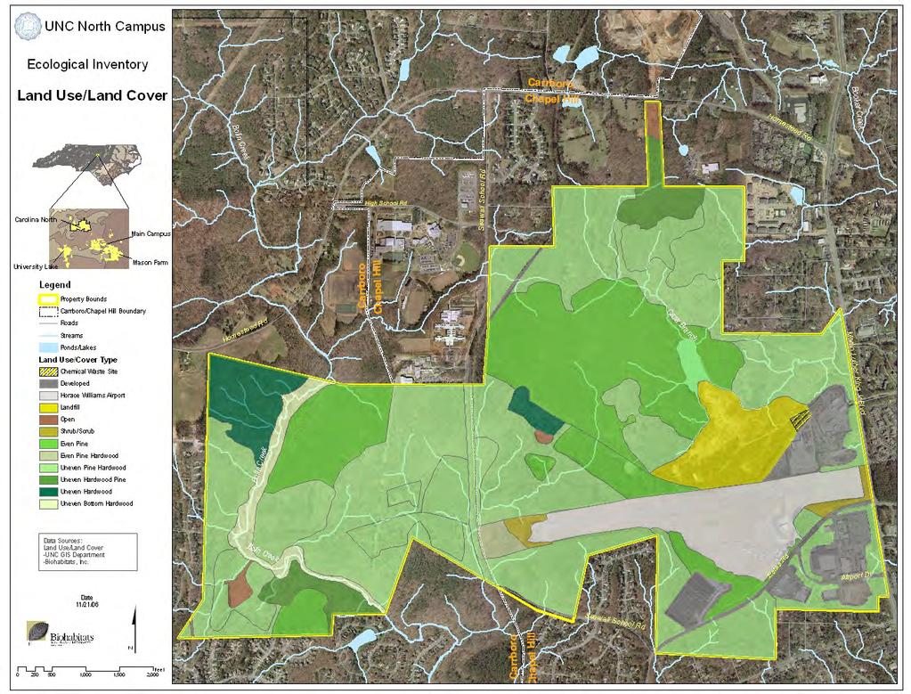
12 Inventory Landuse/Landcover
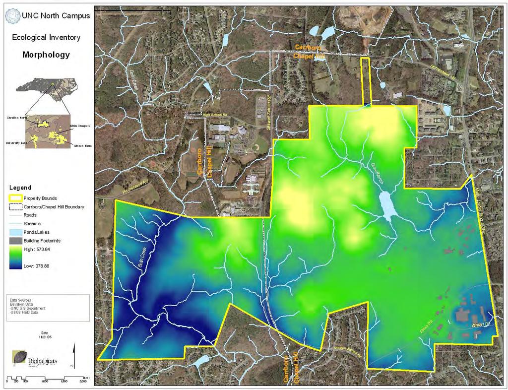
13 Inventory Morphology

14 Inventory Landscape Ecology

15 Inventory Natural Heritage/Landscape Ecology

16 Inventory Cultural, Historic, Recreational Resources
17 Analysis Streams Metric Attributes Site Attribbute Disturbance Will Result in No or Marginal Ecological Impact Disturbance Acceptable If BMPs or Restrictions Are Applied Disturbance will Compromise Ecological Integrity Regulatory Restrictions or Conservation Area Land Suitability Index* No-0 pts Marg-1 pt 2 Points 3 Points +1 Point Streams Hydrologic Regime 1 Ephemeral 1 1 Intermittent Perennial Buffers 2 Regulatory Buffer m Conservation Buffer m Conservation Buffer 1 1 Floodplains 3 Regulatory 100 yr floodplain Morphological 50 yr floodplain 3 3 Aquatic Habitat 4 Aquatic Habitat-High Quality Aquatic Habitat-Mod Quality Aquatic Habitat-Low Quality 1 1 2

18 Analysis Stream Metric Attributes

19 Analysis Stream Metric Suitability Analysis
20 Analysis Wetlands Metric Attributes Site Attribbute Disturbance Will Result in No or Marginal Ecological Impact Disturbance Acceptable If BMPs or Restrictions Are Applied Disturbance will Compromise Ecological Integrity Regulatory Restrictions or Conservation Area Land Suitability Index* Wetlands 5 No-0 pts Marg-1 pt 2 Points 3 Points +1 Point Hydric Soils Hydric Soils Non-hydric soils 0 0 Wetland Size Area < 0.1 ac 2 2 Area ac Area > 0.33 ac Special Isolated Wetland Type Vernal Pool Springs and Seeps Wetland Buffer ' Conservation Bufer '-200' Conservation Buffer 2 2
21 Analysis Wetland Metric Attributes

22 Analysis Wetland Metric Suitability Analysis
23 Analysis Groundwater Metric Attributes Site Attribbute Disturbance Will Result in No or Marginal Ecological Impact Disturbance Acceptable If BMPs or Restrictions Are Applied Disturbance will Compromise Ecological Integrity Regulatory Restrictions or Conservation Area Land Suitability Index* No-0 pts Marg-1 pt 2 Points 3 Points +1 Point Groundwater 7 Recharge Zones High Soil Permeability/Recharge Zone 2 2 Mod. Soil Permeability/Recharge Zone 1 1 Low Soil Permeabity/Recharge Zone 0 0 Depth to Groundwater Depth to Groundwater <1.5' 3 3 Depth to Groundwater 1.5'-4' 2 2 Depth to Groundwater >4' 0 0

24 Analysis Groundwater Metric Attributes

25 Analysis Groundwater Metric Suitability Analysis
26 Analysis Geomorphology Metric Attributes Site Attribbute Disturbance Will Result in No or Marginal Ecological Impact Disturbance Acceptable If BMPs or Restrictions Are Applied Disturbance will Compromise Ecological Integrity Regulatory Restrictions or Conservation Area Land Suitability Index* No-0 pts Marg-1 pt 2 Points 3 Points +1 Point Geomorphology Erodability 7 Erodability K Factor < Erodability K Factor > Slope Slopes 0-15% 1 1 Slopes 15-25% 2 2 Slopes >25% Floodplain Morphological 50 yr floodplain 3 1 4

27 Analysis Geomorphology Metric Attributes
28 Analysis Geomorphology Metric Suitability Analysis
29 Analysis Vegetation Metric Attributes Site Attribbute Disturbance Will Result in No or Marginal Ecological Impact Disturbance Acceptable If BMPs or Restrictions Are Applied Disturbance will Compromise Ecological Integrity Regulatory Restrictions or Conservation Area Land Suitability Index* No-0 pts Marg-1 pt 2 Points 3 Points +1 Point Vegetation Rare Species RTE Species Location RTE Potential Habitat 2 2 Tree Age Tree Age Class 0-50 yrs 1 1 Tree Age Class yrs 2 2 Tree Age Class >75 yrs 3 3 Tree Species Abundance 8 Relative Species Abundance - High 3 3 Relative Species Abundance - Mod. 2 2 Relative Specie Abundance - Low 1 1

30 Analysis Vegetation Metric Attributes

31 Analysis Vegetation Metric Suitability Analysis
32 Analysis Landscape Ecology Metric Attributes Site Attribbute Disturbance Will Result in No or Marginal Ecological Impact Disturbance Acceptable If BMPs or Restrictions Are Applied Disturbance will Compromise Ecological Integrity Regulatory Restrictions or Conservation Area Land Suitability Index* No-0 pts Marg-1 pt 2 Points 3 Points +1 Point Landscape Ecology Corridor Regional Importance 9 Primary Corridors 3 3 Secondary Corridors 2 2 Isolated Corridors 1 1 Corridor Width Site Corridors meters 3 3 Site Corridors meters 2 2 Corridor Structural Integrity Solid->90% forest cover 3 3 Porous-50-90% forest cover 2 2 Stepping Stone-<50% forest cover 1 1 Total Patch Size 10 Forested Habitat Patch > 40 ac 3 3 Forested Habitat Patch ac 2 2 Forested Habitat Patch <25 ac 1 1 Interior Patch Size10 Forested Habitat Patch > 40 ac 3 3 Forested Habitat Patch ac 2 2 Forested Habitat Patch 0-24 ac 1 1
33 Analysis Wildlife Habitat Metric Attributes

34 Analysis Wildlife Habitat Metric Suitability Analysis
35 Analysis Wildlife Metric Attributes Site Attribbute Disturbance Will Result in No or Marginal Ecological Impact Disturbance Acceptable If BMPs or Restrictions Are Applied Disturbance will Compromise Ecological Integrity Regulatory Restrictions or Conservation Area Land Suitability Index* No-0 pts Marg-1 pt 2 Points 3 Points +1 Point Wildlife Habitat Endangered Species Habitat 11 Identified Critical Habitat Rare,Threat. or Spec. Species Hab. Hardwoods > 50 yrs old 2 2 Hardwoods < 50 yrs old 1 1 Migratory Bird Habitat 2 2 Vernal Pool Identified Natural Areas Nat. Her. Prog. or Other Designation 2 2 Cultural & Historic

36 Analysis Landscape Ecology Metric Attributes

37 Analysis Landscape Ecology Metric Suitability Analysis
38 Analysis Cultural/Historical Metric Attributes Site Attribbute Disturbance Will Result in No or Marginal Ecological Impact Disturbance Acceptable If BMPs or Restrictions Are Applied Disturbance will Compromise Ecological Integrity Regulatory Restrictions or Conservation Area Land Suitability Index* No-0 pts Marg-1 pt 2 Points 3 Points +1 Point Cultural Areas Viewsheds Viewsheds - regional 2 2 Viewsheds - site 2 2 Historic Sites Nationally Registered Sites Identified Cult and Hist. Occurences 2 2
39 Analysis Land Suitability Ranking Disturbance will result in no or marginal ecological impact Disturbance acceptable if BMPs or restrictions are applied Disturbance will compromise ecological integrity Regulatory restrictions or conservation area

40 Analysis Composite Metric Suitability Analysis (5 scale)
41 Analysis Composite Metric Suitability Analysis (4 scale)
42 Analysis Composite Metric Suitability Analysis (3 scale)