Public Notice ISSUED: July 1, 2015 EXPIRES: July 31, 2015
|
|
|
- Kelly Harmon
- 5 years ago
- Views:
Transcription
 of Leech Lake and to excavate 0.91 acres (39,532 square feet) of aquatic resource area, including 0.")
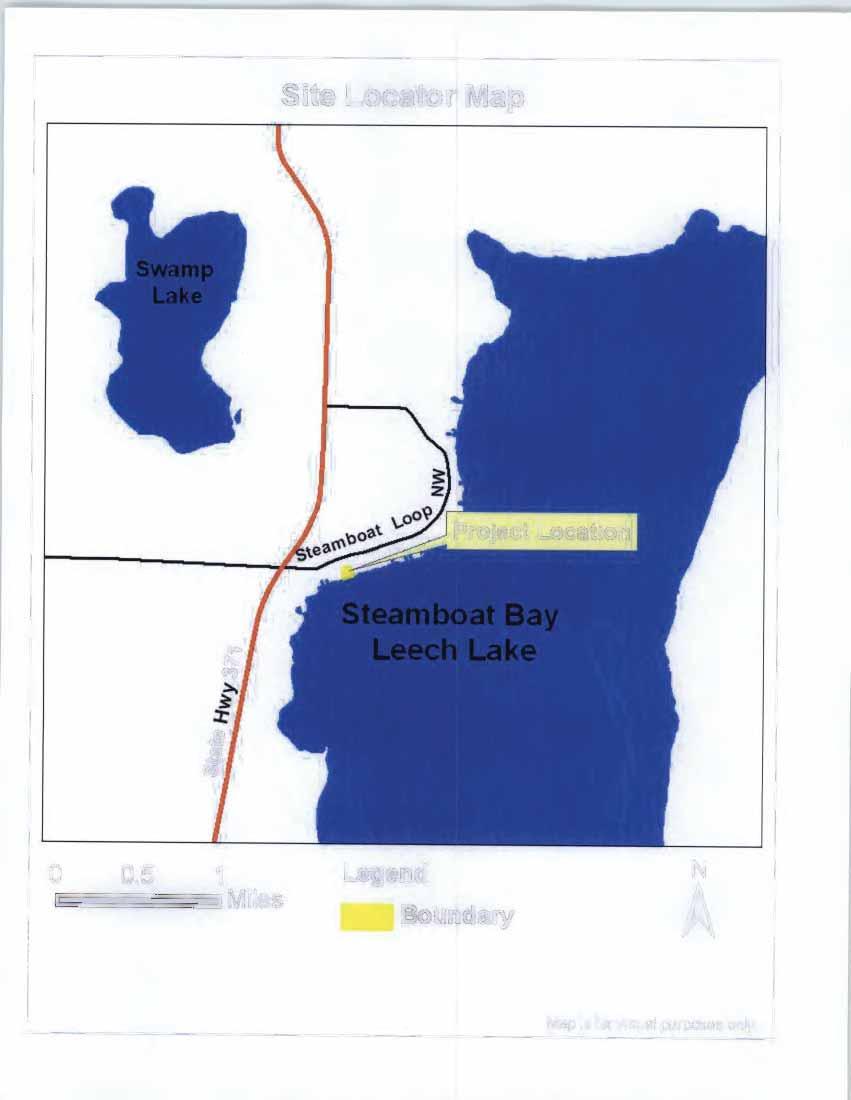
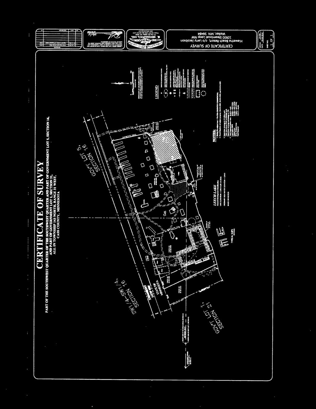
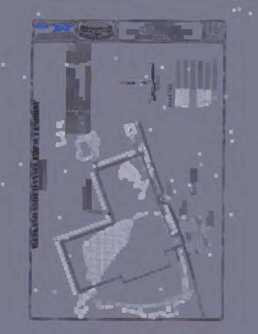
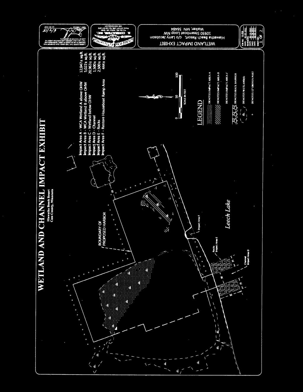
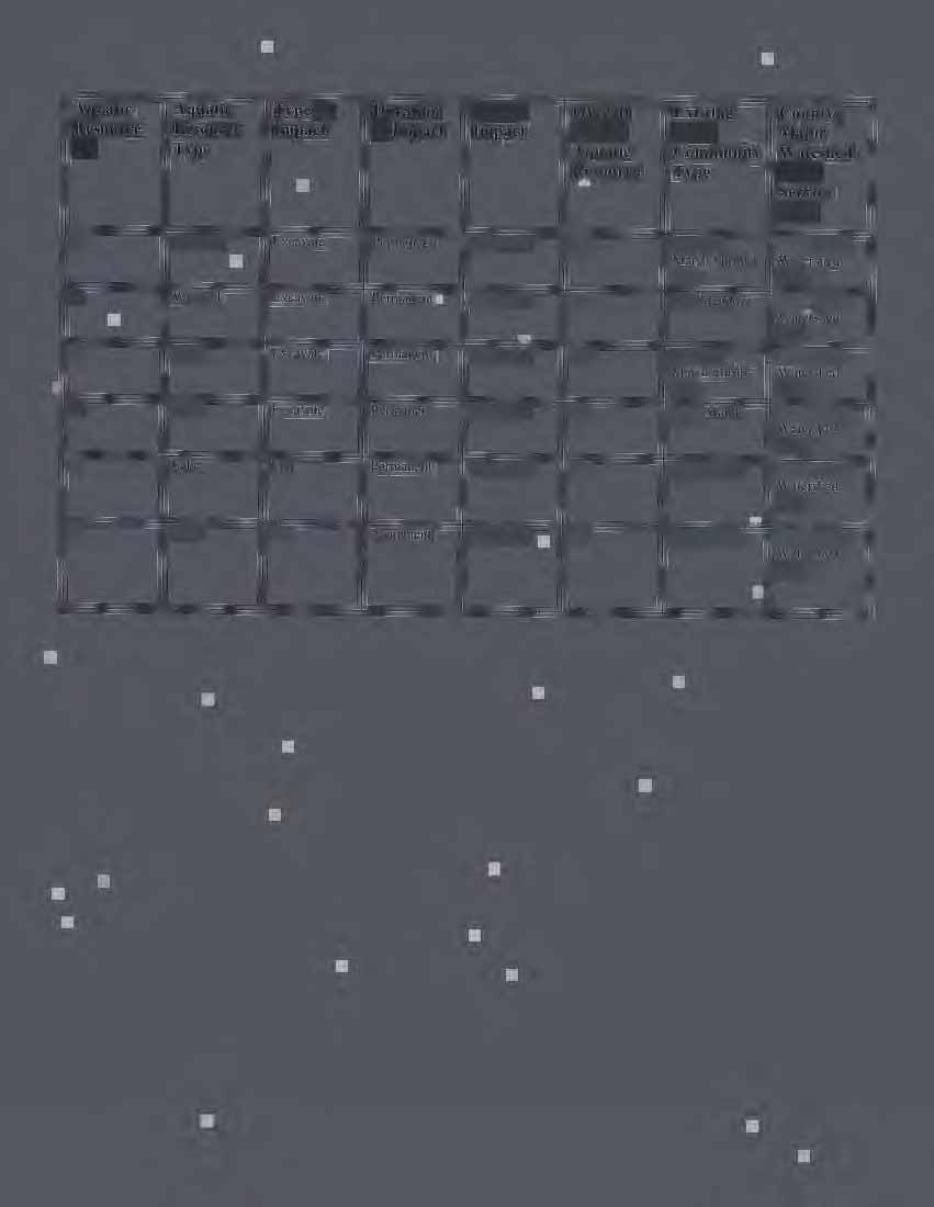
1 APPLICANT: REFER TO: Larry Jacobson, Hiawatha Beach Resort WAB Public Notice ISSUED: July 1, 2015 EXPIRES: July 31, 2015 SECTION Clean Water Act SECTION 10 Rivers and Harbors Act 1. APPLICATION FOR PERMIT TO discharge fill material into 0.07 acres (2,944 square feet) of Leech Lake and to excavate 0.91 acres (39,532 square feet) of aquatic resource area, including 0.03 acres (1,500 square feet) of Leech Lake and 0.87 acres (38,032 square feet) of adjacent wetlands, for the purpose of constructing an inland harbor and entrance channel. 2. SPECIFIC INFORMATION. APPLICANT'S ADDRESS: AGENT: Ben Meister Mr. Larry Jacobson Hiawatha Beach Resort Steamboat Bay Loop NW Walker, Minnesota AGENT S ADDRESS: 8718 Center Drive Breezy Point, Minnesota PROJECT LOCATION: The project site is located in the SW ¼, SW ¼, of Section 16, and the NW ¼, NW ¼, of Section 21, T143N, R31W, Cass County, Minnesota. The approximate UTM coordinates (15N) are E 377,241.5, N 5,227, DESCRIPTION OF PROJECT: The applicant proposes to construct an inland harbor and navigational access channel at an established resort on Leech Lake. The harbor would be constructed by excavation and the installation of steel sheet piling bulkheads supported by 12 diameter, 14 long white oak logs driven in with a crane. The sheet piling bulkheads would be installed around a portion of the harbor perimeter. The harbor would have two boat ramps, floating docks attached to pilings creating 55 ten-foot wide boat-slips, a 30-foot wide navigation channel extending 50 feet into the lake from the current shoreline location, and two 25-foot wide rock riprap shields on either side of the navigational channel. The depth of the created channel and harbor would be a maximum of six feet. The total quantity of dredged and excavated material is estimated to include 13,917 cubic yards of material from the harbor area and 250 cubic yards of material from the entrance channel. Dredged and excavated material would be disposed at a nearby upland location. Excavation would be accomplished with the use of backhoes and excavators. A dragline would also be used to set the docking poles and assist with dredging. QUANTITY, TYPE, AND AREA OF FILL: The proposed project would include 0.06 acres of riprap in Leech Lake to protect the navigational channel and 0.01 acres of fill at the current houseboat launch site. Two boat ramps would be installed after the harbor is excavated. Fill material would consist of gravel, sand and rock.
2 Operations - Regulatory ( WAB) SUBJECT: Notice of Application for Permit VEGETATION IN AFFECTED AREA: Shallow open-water communities along lakeshore are typically dominated by submergent, floating and/or floating-leaved aquatic vegetation. Wetland impact area A was previously partially filled and contains reed canary grass, cattails, rushes and several types of sedges. Wetland area B was previously filled and consists of manicured turf grass. Wetland area C consists of shrub-carr wetlands dominated by willow and alder with sparse herbaceous layer beneath the shrub canopy. SOURCE OF FILL MATERIAL: Fill material would be clean material purchased from a commercial source. SURROUNDING LAND USE: The project is located in a partially wooded lakeshore setting, with land use dominated by residential lakeshore property and commercial recreational facility development. DESCRIPTION OF STRUCTURES: Following excavation, a harbor wall would be constructed with steel sheet pilings installed along the upland edges to prevent side wall erosion. U-type sheet piling bulkheads would be supported by 12 to 14 inch diameter logs driven via crane operated piledriver. Attachment from bulkhead to poles would consist of threaded rod or cable and turnbuckle. Jetties at the harbor mouth would be constructed of rock riprap. DESCRIPTION OF DREDGING OR EXCAVATION: Excavation would take place on 0.56 acres of upland, 0.91 acres of wetlands and 0.03 acres within the lake. Excavation depth would be limited to six feet or less. THE FOLLOWING POTENTIALLY TOXIC MATERIALS COULD BE USED AT THE PROJECT SITE: It is anticipated that any potentially toxic materials used at the site would be consistent with materials found at typical construction sites and associated with heavy equipment use. THE FOLLOWING PRECAUTIONS TO PROTECT WATER QUALITY HAVE BEEN DESCRIBED BY THE APPLICANT: The applicant will utilize Best Management Practices to prevent erosion and sedimentation during construction. MITIGATION: The applicant has proposed to purchase wetland credits from a Corps of Engineers approved mitigation bank the aquatic resource impacts. The applicant proposes to purchase credits at a ratio of 0.5 credits for each acre of impact (0.5:1). 3. REPLIES/COMMENTS. Interested parties are invited to submit to this office written facts, arguments, or objections within 30 days of the date of this notice. These statements should bear upon the suitability of the location and the adequacy of the project and should, if appropriate, suggest any changes believed to be desirable. Comments received may be forwarded to the applicant. Replies may be addressed to Regulatory Branch, St. Paul District, Corps of Engineers, 180 Fifth Street East, Suite 700, Saint Paul, MN
3 Operations - Regulatory ( WAB) SUBJECT: Notice of Application for Permit Or, IF YOU HAVE QUESTIONS ABOUT THE PROJECT, call Bill Baer at the Bemidji Regulatory field office of the Corps, telephone number (651) To receive Public Notices by , go to: and add your information in the New Registration Box. 4. FEDERALLY-LISTED THREATENED OR ENDANGERED WILDLIFE OR PLANTS OR THEIR CRITICAL HABITAT. None were identified by the applicant or are known to exist in the permit area. However, Cass County is within the known or historic range of the following Federally-listed threatened (T) and endangered (E) species: Species Canada lynx (T) Lynx canadensis Gray Wolf (T) Canis lupis Northern Long Eared Bat (T) Myotis septentrionalis Habitat Northern forested areas Northern forested areas Hibernates in caves/mines, swarms in surrounding forests, roosts and forages in upland forests This application is being coordinated with the U.S. Fish and Wildlife Service. Any comments it may have concerning Federally-listed threatened or endangered wildlife or plants or their critical habitat will be considered in our final assessment of the described work. 5. JURISDICTION. This application is being reviewed in accordance with the practices for documenting Corps jurisdiction under Sections 9 & 10 of the Rivers and Harbors Act of 1899 and Section 404 of the Clean Water Act identified in Regulatory Guidance Letter We have made an initial determination that the aquatic resources that would be impacted by the proposed project are regulated by the Corps of Engineers under Section 404 of the Clean Water Act and/or Section(s) 9 & 10 of the Rivers and Harbors Act. The Corps will prepare an approved or preliminary jurisdictional determination prior to making a permit decision. Approved jurisdictional determinations are posted on the St. Paul District web page at Leech Lake is a designated navigable water of the U.S. under the Rivers and Harbors Act. The wetlands located inland from Leech Lake at this site are not considered part of the navigable waters and are not subject to Section 10 of the Rivers and Harbors Act during construction. THE APPLICANT HAS STATED THAT THE FOLLOWING STATE, COUNTY, AND/OR LOCAL PERMITS HAVE BEEN APPLIED FOR/ISSUED: Wetland Conservation Act, Public Waters Work Permit, County Conditional Use Permit 3
4 Operations - Regulatory ( WAB) SUBJECT: Notice of Application for Permit 6. STATE SECTION 401 WATER QUALITY CERTIFICATION. The Leech Lake Reservation Boundary is established at the shoreline at the project location. Portions of the project built lakeward of the shoreline are considered outside of the Reservation. Valid Section 404 permits cannot be issued for any activity unless water quality certification for the activity is granted or waived pursuant to Section 401 of the Clean Water Act. The Section 401 authority on nonreservation lands in Minnesota is the Pollution Control Agency (MPCA). Within the Leech Lake Reservation, the U.S. Environmental Protection Agency (USEPA) is the Section 401 authority. The St. Paul District has provided this public notice and a copy of the applicant s Section 404 permit application form to the MPCA and to the USEPA. If MPCA or the USEPA needs any additional information in order for the Section 401 application to be considered complete, the MPCA and USEPA has indicated that it will request such information from the applicant. It is the permit applicant s responsibility to ensure that the MPCA and the USEPA have received a valid, complete application for Section 401 certification and to obtain a final Section 401 action from the appropriate authority. The EPA has indicated that this public notice serves as its public notice of the application for Section 401 water quality certification under the Clean Water Act. Any comments relative to the EPA 401 certification for the activity proposed in this public notice may be sent to: Ms. Janice Cheng, U.S. EPA, Watersheds & Wetlands Branch, WW-16J, 77W. Jackson Blvd., Chicago IL 60604; cheng.janice@epa.gov. The MPCA has indicated that this public notice serves as its public notice of the application for Section 401 water quality certification under Minnesota Rules Part The MPCA has also indicated that the Section 401 process shall begin to commence upon the issuance date of this public notice unless the MPCA notifies both the St. Paul District and the permit applicant to the contrary, in writing, before the expiration date of this public notice. Any comments relative to MPCA s Section 401 Certification for the activity proposed in this public notice may be sent to: Minnesota Pollution Control Agency, Resource Management and Assistance Division, Attention: 401 Certification, 520 Lafayette Road North, St. Paul, Minnesota HISTORICAL/ARCHAEOLOGICAL. This public notice is being sent to the National Park Service and the State Archaeologist for their comments. The Corps will review information on known cultural resources and/or historic properties within and adjacent to the project area. The Corps will also consider the potential effects of the project on any properties that have yet to be identified. The results of this review and the Corps determination of effect will be coordinated with the State Historic Preservation Officer and the Leech Lake Tribal Historic Preservation Officer independent of this public notice. Any adverse effects on historic properties will be resolved prior to the Corps authorization, or approval, of the work in connection with this project. 4
5 Operations - Regulatory ( WAB) SUBJECT: Notice of Application for Permit 8. PUBLIC HEARING REQUESTS. Any person may request, in writing, within the comment period specified in this notice, that a public hearing be held to consider this application. Requests for public hearings shall state, in detail, the reasons for holding a public hearing. A request may be denied if substantive reasons for holding a hearing are not provided or if there is otherwise no valid interest to be served. 9. PUBLIC INTEREST REVIEW. The decision whether to issue a permit will be based on an evaluation of the probable impact, including cumulative impacts, of the proposed activity on the public interest. That decision will reflect the national concern for both protection and utilization of important resources. The benefit which reasonably may be expected to accrue from the proposal must be balanced against its reasonably foreseeable detriments. All factors which may be relevant to the proposal will be considered, including the cumulative effects. Among those are conservation, economics, aesthetics, general environmental concerns, wetlands, cultural values, fish and wildlife values, flood hazards, floodplain values, land use, navigation, shoreline erosion and accretion, recreation, water supply and conservation, water quality, energy needs, safety, food and fiber production and, in general, the needs and welfare of the people. Environmental and other documents will be available for review in the St. Paul District Office. The Corps of Engineers is soliciting comments from the public; Federal, State, and local agencies and officials; Indian tribes; and other interested parties in order to consider and evaluate the impacts of this proposed activity. Any comments received will be considered by the Corps of Engineers to determine whether to issue, modify, condition, or deny a permit for this proposal. To make this decision, comments are used to assess impacts on endangered species, historic properties, water quality, general environmental effects, and the other public interest factors listed above. Comments are used in the preparation of an Environmental Assessment and/or an Environmental Impact Statement pursuant to the National Environmental Policy Act. Comments are also used to determine the need for a public hearing and to determine the overall public interest of the proposed activity. Ben Cox Chief, Northwest Section Enclosures NOTICE TO EDITORS: This public notice is provided as background information and is not a request or contract for publication. 5
6 WAB Hiawatha Beach Resort - Inland Harbor WAB Page 1 of 6 Project Location Sources: Esri, HERE, DeLorme, USGS, Intermap, increment P Corp., NRCAN, Esri Japan, METI, Esri China (Hong Kong), Esri (Thailand), TomTom, MapmyIndia, OpenStreetMap contributors, and the GIS User Community K Miles Legend BIA Reservation boundary
7 WAB Page 2 of 6
8 WAB Page 3 of 6
9 WAB Page 4 of 6

10 WAB Page 5 of 6


11 WAB Page 6 of 6