NEPA and Design Public Hearings
|
|
|
- Chad Cannon
- 5 years ago
- Views:
Transcription

1 NEPA and Design Public Hearings Monday, December 5, 2016 Washington-Lee High School 1301 N. Stafford Street Arlington, VA Thursday, December 8, 2016 Mary Ellen Henderson Middle School 7130 Leesburg Pike Falls Church, VA Amanda Baxter, VDOT Special Projects Development Manager Mark Gibney, P.E., VDOT Design Manager
2 Today s Hearing Program history and scope Tolling infrastructure construction update Multimodal components update Eastbound widening Existing conditions Design constraints and widening concepts Environmental review process Noise wall process Traffic operational analysis results Project schedule Public outreach and comment period 2

3 Program Area Map 3
4 Program Scope Tolling during weekdays, peak hours, peak directions Eastbound: 5:30 a.m. 9:30 a.m. Westbound: 3:00 p.m. 7:00 p.m. HOV2+ toll free in 2017, HOV3+ toll free when Express Lanes open on I-66 outside the Beltway All vehicles using the lanes during tolling periods must have an E-ZPass or E- ZPass Flex, if they are HOV, mounted in vehicle Multimodal improvements benefitting the I-66 Corridor funded by toll revenue Widening of I-66 eastbound between the Dulles Connector Road and Fairfax Drive-Exit 71 (approximately 4 miles) Preparing an Environmental Assessment Conducting a Noise Analysis to determine locations of noise walls Tolling will continue through construction 4

5 Tolling Infrastructure Construction Update Construction kicked off with groundbreaking in August 2016 Construction activity includes: Eight overhead electronic toll collection gantries on I-66 Approximately 125 signs along I-66 and local roads approaching I-66 Potential traffic impacts Periodic lane closures on local roads approaching I-66 interchanges, ramp closures and night-time lane closures along I-66 itself Brief, occasional total closures of I-66 will occur during overnight construction to install the overhead gantries Construction will conclude in

6 Multimodal Components Update Commonwealth Transportation Board approved 10 projects totaling $9.8 million in July 2016 Projects are expected to be operational by the time tolling begins in 2017 Approved projects include: 6
7 Eastbound Widening Widening of I-66 eastbound from two to three lanes from the Dulles Connector Road to Fairfax Drive (Exit 71) Approximately 4 miles Environmental analysis and construction to be funded with revenues from recently enacted FAST Act and state revenues Analysis of noise walls (potential new/replacement) Landscaping Widening to be completed largely within existing right of way Tolling will continue through construction 7

8 Eastbound Widening Map 8

9 Eastbound I-66 Existing Number Of Lanes Lane On or Off Ramp Not to Scale 9

10 Purpose and Need The purpose of the project is to increase capacity in order to improve traffic operations and reduce congestion issues, as well as address safety needs between the Dulles Connector Road and Fairfax Drive. 10
11 I-66 Eastbound Widening Design Considerations Urban Right-of-Way Corridor Barrier/retaining walls along inside widening to protect Metro facilities New retaining walls for outside widening Pedestrian Facilities Adjacent W&OD and Custis Trail Pedestrian bridge over I-66 retro-fit (between N. Sycamore St. and N. Ohio St.) Three Parks Two Schools Existing Noise Walls 4,000 LF of metal noise walls 1,500 LF of concrete stand alone noise walls 6,450 LF of concrete barrier mounted noise walls Four Bridges I-66 over Williamsburg I-66 over N. Westmoreland I-66 over N. Sycamore I-66 over Custis Westover Park Six Overpasses Storm Water Management Power Transmission Lines 11
12 Key Project Features Third travel lane eastbound between Dulles Connector Road and Fairfax Drive (Exit 71) Trail Improvements Washington and Old Dominion Trail at Lee Highway Custis Trail Realignment in Bon Air Park Replacement and New Construction of Noise Walls along eastbound and westbound travel lanes Off-ramp Intersection Improvements Exit 69 East Falls Church Exit 71 Ballston Stormwater Management 12

13 I-66/Dulles Connector Road Merge Widening Transition Area New Added Lane Lane Configuration 13

14 I-66 Eastbound Widening Concepts Inside Widening Great Falls St. to Patrick Henry Dr. 14

15 I-66 Eastbound Widening Concepts Inside & Outside Widening Patrick Henry Dr. to N. Harrison St. 15

16 I-66 Eastbound Widening Concepts Outside Widening N. Harrison St. to Exit 71 (Fairfax Dr.) 16

17 Trail Improvements W&OD Trail at Lee Highway (US 29) 17

18 Trail Improvements W&OD Trail at Lee Highway (US 29) Looking Southwest from Lee Hwy/Fairfax Dr. Intersection These renderings are conceptual only. Design details, architectural treatments and colors are all subject to change. 18

19 Trail Improvements W&OD Trail at Lee Highway (US 29) Looking Southeast from Lee Hwy/Fairfax Dr. Intersection These renderings are conceptual only. Design details, architectural treatments and colors are all subject to change. 19

20 Trail Improvements Custis Trail Realignment in Bon Air Park 20
21 Environmental Review Process VDOT has prepared an Environmental Assessment (EA) in accordance with the National Environmental Policy Act (NEPA) Includes technical analyses including those related to right of way, socioeconomic, water quality, wetland and streams, threatened and endangered species, air quality, noise, cultural resources, and hazardous materials Noise Analysis and Report Preliminary noise analysis presents results of new sound barriers identified as reasonable and feasible and where existing barriers will be replaced Traffic Analysis and Report 21
22 Environmental Assessment Findings Environmental Resource Property Impacts Community Facilities Environmental Justice (Minority/Low-income) Historic Properties Section 4(f) Protected Properties Noise Air Quality Wetlands and Streams Floodplains Wooded Areas Wildlife and Habitat Threatened and Endangered Species Resource Summary No relocations or displacements are anticipated. Minor permanent right of way acquisition (0.1 acre) and temporary/permanent easements (4.73 acres) associated with the Build Alternative would occur. Impacts include enhancements to the Washington and Old Dominion Trail, Custis Trail and Bon Air Park. No disproportionate impacts. No adverse effect. De minimis impacts to Washington and Old Dominion Trail, Custis Trail and Bon Air Park. Under the No Build Alternative, 236 receptors are predicted to be impacted, under the Build Alternative an additional 113 receptors are impacted (349 total). Approximately 3.7 miles (19,490 linear feet) of noise walls have been preliminarily identified to mitigate noise. This includes the replacement of existing noise walls. No adverse impacts to ambient air quality and no violation of the National Ambient Air Quality Standards. Impacts to linear feet of stream and 0.6 acre of wetlands are expected. Impacts to 0.39 acre of the 100-year floodplain are anticipated. Permanent conversion of wooded areas within the proposed right of way for the Build Alternative is 0.05 acre. Impacts to acres of wooded and semi-wooded areas within the existing VDOT right of way and 0.84 acre within areas of temporary easements. Minimal impacts. The federally listed species, the northern long-eared bat (NLEB), may be affected by the project. However, the project is within a highly-developed urban area, which the USFWS indicates is extremely unlikely to be suitable NLEB habitat. 22


23 Preliminary Noise Analysis Summary Exit 67 Dulles Connector / I-495 Baltimore / Rte. 123 (to I-495 SB) / Dulles Airport Access Road / Dulles Toll Road Exit 68 Westmoreland St : Existing : Existing To be Replaced : Feasible and Reasonable : Feasible not Reasonable : Not Feasible N Sycamore St Not to Scale 23


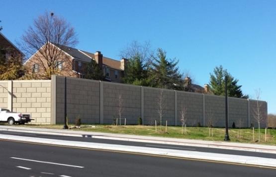
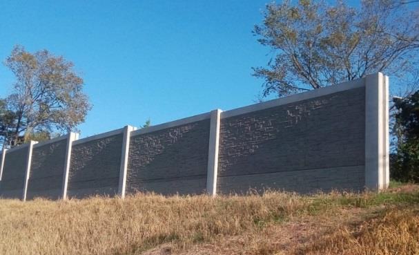
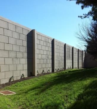
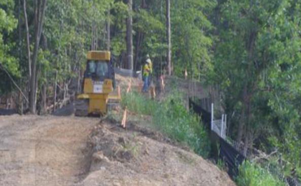
24 Noise Walls Sample Noise Barriers Under Construction Sample Completed Noise Barriers 24
25 Traffic Operational Analysis Traffic and Transportation Technical Report includes: Traffic Flows Average Daily Traffic, AM and PM Peak Hour Volumes Traffic Performance Measures Travel Speeds, Freeway Densities, Travel Times, Queue Lengths, Intersection Levels of Service, Delays Vehicle Trip Types / Composition of Traffic on I-66 (e.g., HOV trips, Buses, Toll Payers) Effects on Transit Use Crash Statistics and Safety Assessments 25
26 2040 Build 2040 No Build 2025 Build 2025 No Build Existing EXIT 64 EXIT 66 EXIT 67 EXIT 68 EXIT 69 EXIT 71 EXIT 72 Eastbound AM Speed Congestion Diagrams I-66 Eastbound AM Peak Hour Speed Comparison Direction of Travel 7:15 AM 7:30 AM 7:45 AM 8:00 AM 7:15 AM 7:30 AM 7:45 AM 8:00 AM 7:15 AM 7:30 AM 7:45 AM 8:00 AM 7:15 AM 7:30 AM 7:45 AM 8:00 AM 7:15 AM 7:30 AM 7:45 AM 8:00 AM 237 Leesburg Pike Dulles Toll Road Connector Westmoreland Street Washington Blvd Fairfax Dr/Ballston Lee Highway (Maywood) Speed Color Scale (mph) 26
27 2040 Build 2040 No Build 2025 Build 2025 No Build Existing EXIT 64 EXIT 66 EXIT 67 EXIT 68 EXIT 69 EXIT 71 EXIT 72 Eastbound PM Speed Congestion Diagrams I-66 Eastbound PM Peak Hour Speed Comparison Direction of Travel 5:00 PM 5:15 PM 5:30 PM 5:45 PM 5:00 PM 5:15 PM 5:30 PM 5:45 PM 5:00 PM 5:15 PM 5:30 PM 5:45 PM 5:00 PM 5:15 PM 5:30 PM 5:45 PM 5:00 PM 5:15 PM 5:30 PM 5:45 PM 237 Leesburg Pike Dulles Toll Road Connector Westmoreland Street Washington Blvd Fairfax Dr/Ballston Lee Highway (Maywood) Speed Color Scale (mph) 27
28 Eastbound PM Travel Time Analysis 28
29 2025 AM Peak Hour Intersection Levels of Service Impact: No-Build vs. Build 29

30 2025 PM Peak Hour Intersection Levels of Service Impact: No-Build vs. Build 30

31 Safety / Crash Analysis On Eastbound I-66 Inside the Beltway Crash Trends Annual crashes per year varies between 60 and 90 per year Future corridor improvements expected to improve safety and operational issues that contribute to crashes Safety Improvements Dual-lane exits at Exits 69 and 71 reduce weaving and queuing onto the interstate Additional continuous lane between Dulles Connector Road merge and Exit 69 improves weaving and reduces potential crashes * Predicted Values Total Annual Number of Crashes on Eastbound I-66 From Dulles Connector Road On-ramp to Exit 71 31
32 Existing Ramp Configuration Exit 69 East Falls Church I-66 Exit 69 Fairfax Dr Lane Configuration Street Parking 32

33 Proposed Ramp Configuration Exit 69 East Falls Church I-66 Exit 69 Fairfax Dr New Added Lane Lane Configuration Street Parking 33
34 Existing Ramp Configuration Exit 71 Ballston 34

35 Proposed Ramp Configuration Exit 71 Ballston 35
36 Eastbound Widening Project Schedule Activities Revised Environmental Assessment and Federal Highway Administration Decision Begin Tolling and Implement Initial Multimodal Projects Dates Early 2017 Mid 2017 Award Design-Build Contract Late 2017 Begin Construction Early 2018 Open New Eastbound Lane Late
 Transit Providers Regular email")

37 Public Outreach Coordination with key stakeholder groups including: Localities (Arlington County, City of Falls Church, Fairfax County, Loudoun County) District of Columbia WMATA Regional Transportation and Commuter Groups (NVTA, NVTC, TPB and Commuter Connections) Transit Providers Regular updates to stakeholder database and robust outreach before meetings and key project milestones Briefings to community groups and outreach at community events 155+ total public meetings and outreach events to date Proactive media outreach Coordination with elected officials Transform66.org project website 37
38 How to Provide Comments COMMENT DEADLINE January 30, 2017 At Tonight s Public Hearing: Mail: Submit written comments on the comment sheet Provide oral comments during the public comment period following the formal presentation or individually to the court reporter Mail written comments to Amanda Baxter, VDOT Northern Virginia District, 4975 Alliance Drive, Fairfax, VA your comments or questions to Transform66@VDOT.Virginia.gov Online: Submit your comments via the online comment form at Transform66.org Reference Transform 66 Inside the Beltway Eastbound Widening in subject line of all correspondence 38
39 THANK YOU Transform66.org 39