Palmer River Water Discharge and Nutrient Study
|
|
|
- Megan Wilkinson
- 5 years ago
- Views:
Transcription
. Palmer River Water Discharge and Nutrient Study. In Watershed Access Lab Projects. Project 85. Available at: http://vc.")
1 Bridgewater State University Virtual Commons - Bridgewater State University Watershed Access Lab Projects Watershed Access Lab 2007 Palmer River Water Discharge and Nutrient Study Recommended Citation Dighton-Rehoboth Regional High School, Dighton, Massachusetts (2007). Palmer River Water Discharge and Nutrient Study. In Watershed Access Lab Projects. Project 85. Available at: This item is available as part of Virtual Commons, the open-access institutional repository of Bridgewater State University, Bridgewater, Massachusetts.

2 Conducted by Dighton-Rehoboth Regional High School Environmental Science Class

3
4 Stream Discharge: Width x Depth x Velocity Nutrient concentration (mg/l) Load: Discharge x Concentration Nutrients examined: - Phosphates - Nitrates - Dissolved Oxygen - ph - Temperature


5 Dissolved Oxygen, Temperature & ph Sensor Sigma Probe Sampler Phospates & Nitrates Tape Measure -Width


6 Velocity Sensor & Depth Rod Wooden Float & Anchor For Mooring sensors Overnight Life Jackets for Analysts going Into Deeper waters. Yikes! 2 of our fearless leaders:mr. Evans & Mrs. Borges-Dubois

7 -Located just off of Route 44 approximately ¾ the way to Seekonk -Rehoboth is <10% Impervious cover -Very quiet, low population density neighborhood


8 Sarah, Christy, Alida, Janine, Leslie, Alyssa, Patrick, Joe, Mark, Devin, & Kirk

9
10
11 Discharge in CFS Discharge by segment-wilmarth Series Segment #
12 Temperature (celcius) Wilmarth: Temperature vs. Time Series :00:00 15:00:00 16:00:00 17:00:00 18:00:00 19:00:00 20:00:00 21:00:00 22:00:00 23:00:00 0:00:00 1:00:00 2:00:00 3:00:00 4:00:00 5:00:00 6:00:00 7:00:00 8:00:00 9:00:00 10:00:00 11:00:00 12:00:00 13:00:00 Time (2pm)
13 ph Wilmarth: ph vs. Time Series :00:00 15:00:00 16:00:00 17:00:00 18:00:00 19:00:00 20:00:00 21:00:00 22:00:00 23:00:00 0:00:00 1:00:00 2:00:00 3:00:00 4:00:00 5:00:00 6:00:00 7:00:00 8:00:00 9:00:00 10:00:00 11:00:00 12:00:00 13:00:00 Time (2pm)
14 Dissolved O2 (mg/l) Wilmarth: Dissolved Oxygen vs. Time Series :00:00 15:00:00 16:00:00 17:00:00 18:00:00 19:00:00 20:00:00 21:00:00 22:00:00 23:00:00 0:00:00 1:00:00 2:00:00 3:00:00 4:00:00 5:00:00 6:00:00 7:00:00 8:00:00 9:00:00 10:00:00 11:00:00 12:00:00 13:00:00 Time (2pm)
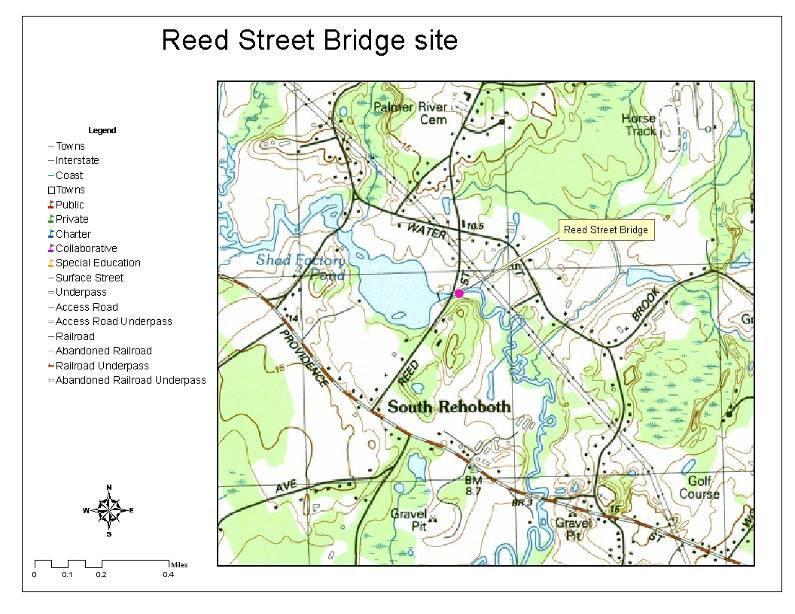
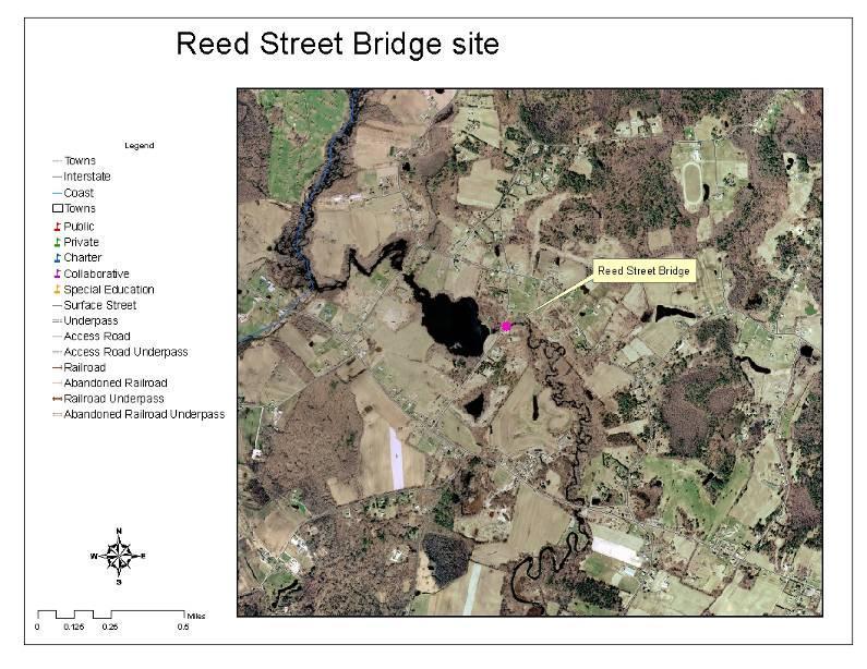
15 -Located in southern Rehoboth Near Swansea - Site of the Shad Factory Pond - Less than 10% Impervious cover - Site of Fish Ladder Reconstruction project


16 Colin, Jeremy, Kristen, Lindsey, Josh, Tyler, Ryan, Spencer, Meghan, Kevin, & Ryan
17
18
19 Discharge in CFS Discharge by segment-reed st Series Segment number
20 Temperature (celcius) Reed Street Temperature vs. Time Series Time (2pm-2pm)
21 ph Reed Street: ph vs. Time Series Time (2pm)
22 Dissolved O2 (mg/l) Reed Street: Dissolved O2 vs. Time Series Time (2pm)
23 Comparison of the 2 sites While the Wilmarth Bridge Road segment is one of many contributors to the overall Palmer River [as well as its downstream Reed Street counterpart], their significance may be partially inferred from the following:
24 Primary Habitat Characteristics Wilmarth Bridge Road Reed Street % Cobble 20-34% (fair) >50% (Excellent) Velocity <0.5 fps (poor) Same (though other regimes were present within the immediate stretch of river Embeddedness 0-25% (excellent) Same Primary Habitat Characteristics Significance of Characteristic % Cobble Indicator of sediment deposition & load carried by river Velocity Embeddedness Figures into Discharge & acts as a selective force on the native Biota Indicator of microhabitats available for different types of biota. Ex: algae, scraperinsects
25 Secondary Habitat Characteristics Velocity/Depth Regimes Riffle Characteristics Wilmarth Bridge Road 2 of 4 present, fast-shallow dominant (good-fair) 40-60% of segment is riffle, riffle is as wide as the stream, but its length is <2x the stream width (good) Reed Street All 4 present (excellent) Same Conditions of Banks (% eroding) <10%, mostly healed (good) Same Bank Vegetation > 90% (excellent) Same Overhead Canopy > 75% (excellent) % (good) Secondary Habitat Characteristics Significance of Characteristic Velocity/Depth Regimes Indicator of the # of microhabitats available can indicate relative level of biodiversity possible & available base for local food chain Riffle Characteristics Conditions of Banks (% eroding) Indicator of relative saturation of dissolved gasses (O2, CO2) Indicates ability of Riparian plants to maintain root integrity as well as how local precipitation affects discharge levels Bank Vegetation Overhead Canopy Indicates soil fertility and overall health of Riparian buffer zone Indicates the relative degree of the temperature-mitigating properties of local Flora
26 Temperature (celcius) Temperature vs. Time - both sites Wilmarth Reed Street :00:00 15:00:00 16:00:00 17:00:00 18:00:00 19:00:00 20:00:00 21:00:00 22:00:00 23:00:00 0:00:00 1:00:00 2:00:00 3:00:00 4:00:00 5:00:00 6:00:00 7:00:00 8:00:00 9:00:00 10:00:00 11:00:00 12:00:00 13:00:00 Time (2 pm)
27 Inferred significance I Observation: Reed Street maintained a higher Temperature than Wilmarth and exhibited fewer variations Hypothesis: This may be because of the higher discharge. The high Specific Heat Capacity of water combined with the shear Volume helped Reed street retain the heat & exhibit less day/night variation
28 ph ph vs. Time - both sites Wilmarth Reed Street :00:00 15:00:00 16:00:00 17:00:00 18:00:00 19:00:00 20:00:00 21:00:00 22:00:00 23:00:00 0:00:00 1:00:00 2:00:00 3:00:00 4:00:00 5:00:00 6:00:00 7:00:00 8:00:00 9:00:00 10:00:00 11:00:00 12:00:00 13:00:00 Time (2pm)
29 Inferred significance II Observations: 1. There was no significant overnight lowering of ph in either site. 2. Wilmarth Bridge Road site exhibited more basic ph s than Reed Street Hypotheses: 1. Turbulent (rather than laminar) flow helped keep gas concentrations from being highly variable. This, in turn, kept CO2 levels from contributing to acidity overnight (Carbonic acid) 2. There may be an underlying geological reason: perhaps the area surrounding this site contains Basic rock and/or weathered Bicarbonate (HCO3-) ions; which can slow the effects of acidification by neutralizing contributors like acid rain and contaminated runoff.
30 Dissolved Oxygen (mg/l) Dissolved Oxygen vs. Time - both sites Wilmarth Reed Street :00:00 15:00:00 16:00:00 17:00:00 18:00:00 19:00:00 20:00:00 21:00:00 22:00:00 23:00:00 0:00:00 1:00:00 2:00:00 3:00:00 4:00:00 5:00:00 6:00:00 7:00:00 8:00:00 9:00:00 10:00:00 11:00:00 12:00:00 13:00:00 Time (2pm)
31 Inferred Significance III Observations: 1. Both sites do2 levels drop off in the evening hours. 2. Wilmarth Bridge Road s drop-off seems to occur earlier. Hypotheses: 1. Halted photosynthetic activity (sunset) coupled with continued respiration shifts a balance of gasses to an output of CO2 (respiration) with no O2 input (due to halted photosynthesis) 2. Perhaps the higher percent of canopy cover at this site provided significant shade to halt photosynthesis earlier in the evening than at Reed Street.
32 Phosphate Concentration (P/L) Phosphate levels vs. Time - Both Sites Wilmarth Reed Street Time (2pm)
33 Noted patterns & irregularities for Phosphate levels 1. No data was available for Wilmarth Bridge road at 8AM or at Reed St. at midnight. The analysis registered an airspike for these samples 2. All values were AT or BELOW detection limits - This would suggest that phosphates are at a low enough level to be a limiting factor for both sites
34 N-NO3 concentration (mg/l) N-NO3 concentration vs. Time - both sites Wilmarth Reed St Time (2pm)
35 Noted patterns & irregularities for Nitrate (NO3) levels 1. All levels were above detection limits of the analyzing device - This suggests that NO3 is NOT a limiting factor for either site 2. Concentrations were higher at Reed Street. - With higher discharge, we would expect lower concentrations. So this tells us that between these 2 sites, there must have been a significant addition of NO3 to the Palmer River - Between the 2 sites are farmland, wooded marshes, a golf course, and low-density residential areas


36 Inferred Significance IV Observation: Bent shape to Riparian Trees at both sites Hypothesis: Trees have corrected their growth toward the sun (phototropism) in response to erosion taking the soil around their roots away
37 Load -Kg/day Load Kg/day PO4 Load - both sites NO3 Load Wilmarth Reed 3.00 Wilmarth Reed PO4 Load 0.00 NO3 Load
38 Significance of Load Load is higher at Reed street: This is at least partially (though not proportionally) due to the increased discharge Q=w*d*u Lower amounts of PO4 suggest that this IS a limiting factor in the Palmer River. Increased amounts of NO3 could be attributable to runoff from nearby farms &/or the Golf course. These levels suggest a low-average level for BOTH nutrients examined


39 Pretending to have hand-feet Pretending to be a troll under the bridge! Keeping warm & playing Hide n seek! Wondering if the Teacher Can be the first to get Wet!

40 Hot Dunkies on a COLD morning!!!