INTEGRATING HAZARD MITIGATION INTO COMPREHENSIVE PLANNING THE GLADES COMMUNITIES OF PALM BEACH COUNTY, FL
|
|
|
- Melina Ramsey
- 5 years ago
- Views:
Transcription


1 INTEGRATING HAZARD MITIGATION INTO COMPREHENSIVE PLANNING THE GLADES COMMUNITIES OF PALM BEACH COUNTY, FL THE CITY OF BELLE GLADE January 15, 2007
2 Executive Summary The experiences of the 2004 and 2005 hurricane seasons epitomize the importance of better integrating hazard mitigation activities into local comprehensive planning. In 2004, residents all over the state experienced significant damages from Hurricanes Charley, Frances, Jeanne, and Ivan as a result of winds, tornadoes, surge, and/or flooding and in 2005 from Hurricanes Dennis and Wilma. In the Glades Communities land subsidence presents a major issue for both current and future structures and infrastructure as well as their agriculture based economy. Due to the recent questioning of the structural soundness of the Herbert Hoover Dike around Lake Okeechobee, dike breach and inland flooding hazards have been in the spotlight in these communities as well. The cost of recovery for these various disasters ranges from hundreds of thousands to billions of dollars, significantly taxing local, State, and federal financial sources. Losses covered through federal funding as a result of the 2004 hurricanes alone could reach as high as $7 billion. Worst of all, however, are the many lives that, directly or indirectly, are lost due to natural disasters. It is imperative that we reduce the human and financial costs of natural disasters. Through better integration of natural hazard considerations into local comprehensive planning, we can build safer communities. This City of Belle Glade analysis has been prepared as part of a statewide effort by the Florida Department of Community Affairs to guide local governments in integrating hazard mitigation principles into local Comprehensive Plans. This analysis will also help to support the efforts of the Plan Revision Subcommittee of the Palm Beach County LMS Steering Committee in their efforts to revise the countywide Local Mitigation Strategy and to promote plan integration for all jurisdictions within Palm Beach County. Information provided in this analysis will enable planners to (1) convey the City of Belle Glade existing and potential risk to identified hazards; (2) assess how well local hazard mitigation principles have been incorporated into the City s Comprehensive Plan; (3) provide recommendations on how hazard mitigation can be better integrated into the Comprehensive Plan; and (4) determine if any enhancements could be made to the Local Mitigation Strategy (LMS) to better support comprehensive planning. Best available local and statewide level data are provided to convey exposure and risk as well as illustrate the vulnerability assessment component of the integration process. In this analysis, we present information on the integration of hazard mitigation into comprehensive planning through an examination of population growth, the hazards that put the City at risk, the special needs population and structures that could be affected by these hazards, and the distribution of existing and future land uses in different hazard areas. We hope that this analysis will serve as an example of the issues each jurisdiction should consider as they update their comprehensive plans to include hazard mitigation. The profile also contains a review of the LMS and the Comprehensive Plan. Based on the analysis and review, we were able to develop specific options for the City on how to more effectively integrate hazard mitigation into the Comprehensive Plan and how to enhance the LMS so that it is also a better tool for local planners and officials. During our review, we found that the City of Belle Glade had many strengths and challenges regarding hazard mitigation in both its LMS and Comprehensive Plan, and these are outlined in the analysis. There are always ways to further strengthen such plans and the following is a summary of some of the options that would enable the City to do so. Draft 1/14/2007 FLORIDA DEPARTMENT OF COMMUNITY AFFAIRS i
3 THE CITY OF BELLE GLADE SUMMARY OF RECOMMENDATIONS The following is a summary of preliminary recommendations for the City of Belle Glade. The complete explanation of the recommendations can be found starting on page 21 of this document. Continue intergovernmental coordination through out the Glades Communities by strengthening the Goals, Objectives and Policies in the Intergovernmental Coordination Element of the Comprehensive Plan. Further strengthen the City s infrastructure by placing projects in the Capital Improvements Plan of the Comprehensive Plan as well as on the Hazard Mitigation Prioritized Project list found in the LMS. Create an educational program on the benefits of hazard mitigation and planning geared towards citizens, City Officials and Elected Officials in order to help build support for these town initiatives. Consider sending planning and emergency management staff to area workshops on various hazard mitigation grant programs offered by FDEM and FEMA, as well as general grants writing classes. Continue to search for ways to provide adequate housing for the low income, special needs and farm worker residents in the community. Use this analysis to create a strategy of initiatives and projects as well as a blueprint for reducing potential losses for the City of Belle Glade during the Palm Beach County LMS update process. Consider the inland flooding and stormwater runoff impacts that de-mucked properties may have on surrounding properties and develop best practices for developing in areas prone to land subsidence. Integrate hazard mitigation into the planning phases of the development of the Torry Island Marina area through the use of overlay districts. Complete an inventory of existing mitigation practices for the purpose of documenting inkind match opportunities. Contact the Palm Beach County Division of Emergency Management about the possibility of using global match when preparing grant applications. Develop a public awareness program concerning wildfire and home ignition mitigation as it relates to the specific problems faced by the Glades Communities. Utilize setbacks and defensible space buffers to further mitigate the impacts of wildfire/sugarcane and muck fire on homes that may be adjacent to fields subject to planned seasonal burnings. Consider the creation of a policy in the Comprehensive Plan to update the Land Development Regulations for the City to include wildfire/home ignition principles for large developments. Draft 1/14/2007 FLORIDA DEPARTMENT OF COMMUNITY AFFAIRS ii
4 Explore the City s building regulations with regards to structures and infrastructure constructed on muck soil to determine whether or not there is a uniform building code policy and mitigation options for land subsidence. Coordinate with the National Flood Insurance Program to determine how often the cities should be mapped for flood prone areas due to the land subsidence and changing topography of the Glades Communities. Examine a comprehensive approach to mitigate land subsidence taking into consideration current and future structures and infrastructure, local building codes as well as land development regulations so as to not create new issues such as home ignition or flooding hazards while mitigating land subsidence. Take an active participation role during the LIDAR topography analysis in order to make sure that local knowledge is integrated into the study. Use transportation study to help identify projects to place in the Capital Improvements Plan as well as the LMS Hazard Mitigation project list. Explore the possibility of retrofitting structures to create shelter locations in the Glades Communities. Analyze local and regional clearance and evacuation times and then use this information to direct development and population growth. Identify critical infrastructure and roadway segments where monitoring equipment and modified traffic signal timings could reduce the need for physical presence to conduct traffic control. Other recommendations have been taken from the Draft Herbert Hoover Dike Evacuation Guidance Document, and suggested as incorporations into both the LMS and Comprehensive Plan. Draft 1/14/2007 FLORIDA DEPARTMENT OF COMMUNITY AFFAIRS iii
5 Table of Contents Executive Summary... i 1. Municipal Overview Hazard Vulnerability Existing Mitigation Measures Comprehensive Plan Review Recommendations Sources Attachments... Attachment A: Maps of the Existing and Future Land Uses within the 100-year A-1 Floodplain... Attachment B: Maps of the Existing and Future Land Uses within Wildfire Susceptible Areas B-1 Attachment C: Maps of the Existing and Future Land Uses within Land Subsidence Areas C-1 Attachment D: Palm Beach County Local Mitigation Strategy Goals and Objectives D-1 Attachment E: Comprehensive Plan Excerpts Related to Hazard Mitigation E-1 Draft 1/14/2007 FLORIDA DEPARTMENT OF COMMUNITY AFFAIRS iv
.")
6 1. Municipal Overview Geography and Jurisdictions is located in Central South Florida and borders Lake Okeechobee in an area called the Glades Communities of Palm Beach County. The City covers a total of 4.6 square miles with an average population density of 3,251 people per square mile (U.S. Census, 2000). Population and Demographics Official 2004 population estimates for all of the Glades Communities including the City of Belle Glade as well as the percent change in population from the 2000 U.S. Census are presented in Table 1.1. The neighboring Glades Communities have also been presented due to the fact that planning for evacuation and infrastructure is a regional issue. Therefore it is important to take into consideration the decisions that neighboring communities are making concerning population growth. The most current estimated population of the City of Belle Glade is 14,956 people (University of Florida, Bureau of Economic and Business Research, 2004). Between 1990 and 2000, the City of Belle Glade as a whole had a growth rate of -8.2%, which was far less than the statewide growth rate of 23.5% in those 10 years. Table 1.1 Population Estimates by Jurisdiction Jurisdiction Population, Census 2000 Population Estimate, 2005 % Change, % of Total Population (2004) Belle Glade 14,906 14, % 59.2% Pahokee 5,985 6, % 24.7% South Bay 3,859 4, % 16.1% Glades Communities Total 24,750 25, % 100.0% Source: University of Florida, Bureau of Economic and Business Research, According to FDHC (2006), Belle Glade s population is projected to decrease over the next 19 years, reaching 12,923 people by the year Glades Communities officials hope to stimulate growth in the coming years through various economic and community development initiatives, which may increase the population. City officials also point out that there are many undocumented farm workers that create a seasonal population influx during prime farming months. Figure 1.1 illustrates population projections for Belle Glade and other Glades Communities based on 2000 U.S. Census data calculations. also hopes to spur population growth through specific development initiatives such as the current initiative to develop the Torry Island Marina (see Figures 1 and 2). Currently at this location there is an RV Campground with various trails for recreational use. City officials have expressed an interest in developing this area for ecotourism such as kayaking, canoeing and camping. According to a recent article in the Palm Beach Post, In June, the state legislature approved $1.5 million for an engineering study to put locks into the dike in Belle Glade, which could greatly increase recreational activities and also boost land values. The same article also points out the lower cost of housing in the Glades versus the east coast of Palm Beach County. If this area is targeted for growth through tourism and lower housing costs the projected population could increase instead of decrease, as currently anticipated. Draft 1/14/2007 FLORIDA DEPARTMENT OF COMMUNITY AFFAIRS 1
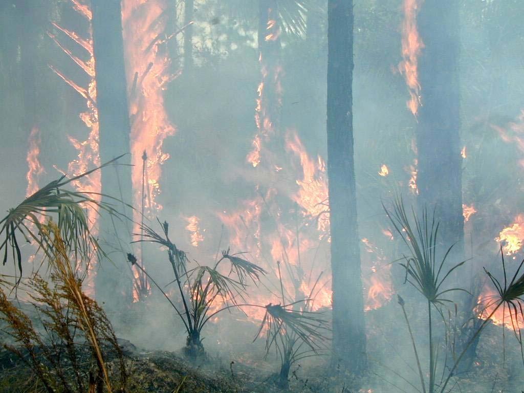
7 Figure 1.1 Population Projections for the City of Belle Glade, Population 15,000 14,500 14,000 13,500 13,000 12,500 12,000 11, Year Source: FDHC, Of particular concern within the City of Belle Glade s population are those persons with special needs and/or limited resources such as the elderly, disabled, low-income, or language-isolated residents. According to the 2000 U.S. Census, 8.7% of Belle Glade residents are listed as 65 years old or over, 24.0% are listed as having a disability, 33.0% are listed as below poverty, and 36.9% live in a home with a primary language other than English. 2. Hazard Vulnerability Hazards Identification The following are natural hazards that pose a risk to communities within Palm Beach County as identified in the County s Local Mitigation Strategy (LMS): hurricane / tropical storm, flooding, severe thunderstorm / lightning, wildfire, muck fire, tornado, extreme temperatures, soil collapse and beach erosion, agricultural pest and disease, drought, epidemic, and seismic hazards. These hazards are analyzed in Section 3.2 of the LMS. Also, Appendix A of the LMS lists specific hazards for the county and each jurisdiction, and incorporates a risk, exposure, vulnerability, and frequency rating into the analysis (Palm Beach County. 1999). The Palm Beach Countywide LMS Appendix A shows that floods, hurricanes, severe thunderstorms, and drought all pose a high risk to the City of Belle Glade. Temperature extremes and tsunamis are a moderate risk, and wildfire, muck fire, soil / beach erosion, and seismic hazards are low risk. Hazards Analysis The following analysis looks at the three major hazard types that local officials decided were the most significant in this area: flooding, wildfire and land subsidence. All of the information in this section, except the evacuation and shelter estimates, was obtained through the online Mapping for Emergency Management, Parallel Hazard Information System (MEMPHIS). MEMPHIS was designed to provide a variety of hazard related data in support of the Florida Local Mitigation Strategy DMA2K revision project. It was created by Kinetic Analysis Corporation under contract with the Florida Department of Community Affairs (FDCA). Estimated exposure values were determined using the Federal Emergency Management Agency's (FEMA s) designated 100-year flood zones (A, AE, V, VE, AO, 100 IC, IN, AH), and the Florida Division of Forestry s Fire Risk Assessment System, levels of concern 5 through 9 for wildfire. For more details on a particular hazard or an explanation of the MEMPHIS methodology, consult the MEMPHIS Web site ( Draft 1/14/2007 FLORIDA DEPARTMENT OF COMMUNITY AFFAIRS 2
8 Existing Population at Risk Table 2.1 presents the estimated Citywide population at risk from hazards, as well as a breakdown of the sensitive needs populations at risk. The first column in the table summarizes the residents of Belle Glade that live within FEMA Flood Insurance Rate Map zones that signify special flood hazard areas. According to these maps, 5.5% of the population, or 827 people, are within the 100-year flood zone. Wildfire is also a hazard of concern to the County, with 29.0% of the population living in medium- to high-risk wildfire zones. The data indicates that 25% of those at risk from wildfire are disabled, making a quick evacuation difficult. Table 2.1 Estimated Number of Persons at Risk from Selected Hazards Population Flood Wildfire (medium-high risk) Minority 0 1,724 Over Disabled 0 1,077 Poverty Language Isolated Single Parent Citywide Total 827 4,336 Evacuation and Shelters Source: Florida Department of Community Affairs, 2005a. Evacuation and clearance times help a community to determine whether or not it has adequate infrastructure to support current and future populations, should the area need to be evacuated for an emergency. This information is displayed as the number of hours it would take to evacuate a certain population given certain conditions such as infrastructure. This data is not available for the Glades Communities area, however the Draft Herbert Hoover Dike Evacuation Guidance Document created by the Palm Beach County Division of Emergency Management identifies the identification of evacuation clearance times for the Glades Communities as a recommendation to be taken for these communities specifically. Some experts have suggested that counties should try to achieve 12 hours or less clearance time for a Category 3 hurricane. This is due to the limited amount of time between the National Hurricane Center issuing a hurricane warning and when the tropical storm-force winds make landfall. Most of the shelters located within Palm Beach County are along the eastern coastal areas and not within the Glades Communities, which may present a problem for those wishing to seek shelter in these areas that may not have adequate transportation or means to drive east to the shelter locations. Additionally, storm events requiring evacuation typically impact large areas, often forcing multiple counties to issue evacuation orders and placing a greater number of evacuees on the major roadways, further hindering evacuation progress. Thus, it is important to not only consider evacuation times for Palm Beach County, but also for other counties in the region as shown in Table 2.2. Draft 1/14/2007 FLORIDA DEPARTMENT OF COMMUNITY AFFAIRS 3
9 Table 2.2 County Evacuation Clearance Times in Hours (High Tourist Occupancy, Medium Response) County Hurricane Category Broward Miami-Dade Monroe Palm Beach Note: Best available data as of 7/05 Source: State of Florida, 2005 (some counties may be in the process of determining new clearance times) Coupled with evacuation is the need to provide shelters. Due to the fact that shelter deficits are determined on a countywide basis and evacuation is a regional issue, Palm Beach County deficit information as well as several neighboring counties has been evaluated. If adequate space can be provided in safe shelters for Palm Beach County residents, then this could be a partial solution to the ever-increasing clearance times for evacuation. Belle Glade has one storm shelter, Glade Central High School, with a capacity of 3,800 people. Also, the State Shelter Plan reports that there is space for 38,065 people in the County s shelters, and there are 3,949 more people that will need sheltering in the case of a Category 5 hurricane. It is projected that by 2009 the deficit will increase to 10,266 people in need of space (FDCA, 2004). Currently the Palm Beach County Division of Emergency Management is undertaking a planning process to assess the evacuation and sheltering needs of the Glades Communities with special emphasis on the needs, should there be a breach or failure of the Herbert Hoover Dike, located around Lake Okechobee. The following is a statement concerning the evacuation conditions in Palm Beach County taken from the Herbert Hoover Dike Emergency Evacuation Guidance Document: The objective of an evacuation is to move the vulnerable or affected population away from the identified threat. In Palm Beach County there are relatively few hurricane evacuation routes available. Those roadways that do exist, such as US-27, SRT-80, and US-441, typically consist of two lanes with limited capacity and have periodic at-grade intersections with other roadways. While those routes provide paths to evacuate to the south and east, only SR-700, which closely parallels Lake Okechobee, exists as a primary route to move Palm Beach County residents to the north. If this route to the north is compromised by an event, (e.g. the road is flooded, [or fallen power lines have obstructed the evacuation route]) few alternative routes currently exist to directly transport the evacuating people in Palm Beach County to the north. This plan contains detailed information on primary and secondary evacuation routes as well as the public sheltering needs of the Glades Communities. A draft version of this plan is currently available online at the following address: City officials are encouraged to review this plan with respect to their jurisdictions to determine the best plan of action for their communities. Existing Built Environment While the concern for human life is always of utmost importance in preparing for a natural disaster, there also are large economic impacts to local communities, regions, and even the State Draft 1/14/2007 FLORIDA DEPARTMENT OF COMMUNITY AFFAIRS 4

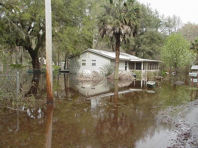
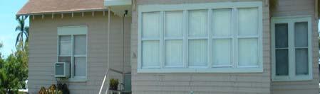
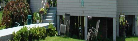
10 when property damages are incurred. Table 2.3 presents estimates of the number of buildings in the City of Belle Glade by structure type that are at risk from each of the four hazards being analyzed. Flooding presents a large risk to property in the City, with 764 structures within a flood zone. A majority of those structures are mobile and multi-family homes. According to the latest National Flood Insurance Program Repetitive Loss Properties list, there are no homes in Belle Glade that have had flood damage multiple times and received insurance payments but have not remedied the recurring problem. Flooding is also a concern in the Torry Island Marina area located along Lake Okeechobee in the City of Belle Glade. During Hurricane Wilma, City Officials stated that the area received a significant amount of flooding, which damaged some of the structures on the property as well as the recreational trails located in the area. This flooding also brought a large amount of debris into the area that had to be cleared following the storm. According to City Officials, approximately $1 million in FEMA funding will be used to update the facilities in this area. They plan to upgrade the bathroom structures, trails, boat ramps as well as the RV Campground located in the Marina area. Figures 1 and 2 show the Torry Island Marina area in its current state. Figure 1: Torry Island Marina Area in the City of Belle Glade Figure 1 shows the Torry Island Marina area locatd in the City of Belle Glade. This area will be targeted for future ecotourism development such as kayaking, canoeing, camping, fishing and hiking. Source: CSA, Draft 1/14/2007 FLORIDA DEPARTMENT OF COMMUNITY AFFAIRS 5

11 Figure 2: The RV Campground at the Torry Island Marina Area in the City of Belle Glade Figure 2 shows the Torry Island Marina Campground in its current state. Belle Glade City Officials plan to use approximately $1 million in FEMA funds to upgrade and expand the facilities in this area. Mitigation techniques such as the elevation and/or hardening of public restrooms and utilities should be considered when upgrading this area with FEMA funding. As discussed previously in this analysis, the City of Belle Glade wishes to develop this area for ecotourism opportunities such as kayaking, canoeing, fishing, camping and hiking. The fact that this development process is still in the planning phases presents an opportunity for City officials to consider hazard mitigation opportunities when developing this site. Table 2.3 also shows single-family homes are also at risk from wildfire, with 44% of the total 831 structures at risk being single-family homes. Also, there are 178 multi-family homes within this hazard area. In addition to wildfire, the seasonal burning of sugarcane fields presents a home ignition hazard for homes adjacent to agricultural areas. Due to techniques used to mitigate the impacts of land subsidence to homes, this issue is amplified. Additional information and illustrations are provided on page 8 detailing how land mitigation techniques used to alleviate the problems resulting from land subsidence can lead to a home ignition problem in the agricultural areas of the Glades Communities. Table 2.3 Estimated Number of Structures at Risk from Selected Hazards Wildfire (medium- high Structure Type Flood risk) Single-Family Homes Mobile Homes Multi-Family Homes Commercial Agriculture Gov./Institutional 0 38 Total Source: Florida Department of Community Affairs, 2005a. Draft 1/14/2007 FLORIDA DEPARTMENT OF COMMUNITY AFFAIRS 6

12 Although land subsidence is not examined in Table 2.3, it too has a major impact on the existing built environment. The heart of the Glades Communities lies within its agricultural based economy. This is largely due to the abundance of a mineral enriched organic soil type, called muck. This soil is a by-product of the hydric conditions around Lake Okeechobee prior to the construction of the Herbert Hoover Dike. According to a report written by George H. Synder titled, Everglades Agricultural Area Soil Subsidence and Land Use Projections: The organic soil (Histosols) of the Everglades Agricultural Area (EAA) formed when organic matter (OM) production exceeded OM decomposition because flooded conditions limited the oxygen needed by aerobic soil organisms which converted the OM to carbon dioxide and water. Since the onset of extensive drainage in the EAA, OM decomposition has been exceeding production resulting in the loss of soil and a lowering of the surface elevations (subsidence). Prior to Everglades drainage, organic soil subsidence was well known in other locations, and it has been carefully documented in the EAA for nearly a century. Simply put, the muck that is so important to the agricultural economy of the Glades Communities is subsiding at an average rate of approximately 0.6 inches each year. The picture below shows the rate of land subsidence in the EAA over an 80 year period. Figure 3: University of Florida Everglades Research and Education Center Figure 3 shows a picture taken in 2003 of a concrete post driven into the organic soil at the University of Florida Everglades Research and Education Center, Belle Glade, in 1924, when the soil surface was even with the top of the post. Source: Synder, 2004 The rapid subsidence of the soil also causes complications with the foundations of structures and infrastructure built on this soil type. Without mitigating the impacts of building in these areas, the foundation of buildings and infrastructure will settle and crack, rendering it unsafe for use. According to a South Bay City Official it is common practice to drive posts underneath the foundation of the house down to the limestone solid bedrock below. As the land surface elevation lowers, the posts are gradually exposed. To the uninformed eye, it appears that these buildings are elevated to mitigate flood impacts. The picture below shows a house using this mitigation technique. Draft 1/14/2007 FLORIDA DEPARTMENT OF COMMUNITY AFFAIRS 7


13 Figure 4: Glades Community House Subject to Land Subsidence Figure 4 shows a house in the Glades Communities, with an exposed foundation due to the impacts of land subsidence. The second overlay picture shows a close up of the foundation of the house. Source: CSA, However, the exposed area underneath the house creates a home ignition/fire hazard issue that in many cases can prevent homeowners from getting insurance on their houses. While this area is not considered to have a significantly high risk for wildfire, the frequent seasonal planned burning of the sugarcane fields can present a problem for homes that are adjacent to these agriculture areas. As shown in the picture above, the exposed area underneath the house is often used for storage of items such as patio furniture, gas cans, lawn mowers and other equipment and items that homeowners may wish to protect from the outside weather elements. If the lofted embers, a byproduct of the sugarcane fire, were to reach the nearby home, they could ignite the stored items under the house and create a situation where the home is ignited from underneath, which can sometimes be a difficult situation to control. Another practice used to mitigate the impacts of land subsidence to structures is the de-mucking of the area intending to be developed. This can either apply to the whole lot or just the footprint of the building. Using this process, the muck is excavated from the property and replaced with a solid substrate. The excavated muck can then be sold to farmers in the EAA to place on their slowly subsiding croplands. This benefits the farmers as well due to the fact that in many places formally used to grow crops, the soil is now very shallow or showing the limestone bedrock below which can damage farm equipment. De-mucking, however, is not without its side effects. As the property surrounding the de-mucked area continues to subside, it elevates the de-mucked area, which can lead to water runoff and flood problems in the area where this problem did not previously exist. This can also lead to areas of pooled water after rainstorms which create both flood hazards and a possible hazard for children who may be playing near the pooled water. Belle Glade City Officials also recognize inadequate and sub-standard housing as a challenge faced by the Glades Communities. Goal 3.2 in the Belle Glade Comprehensive Plan states, Ensure an adequate supply of safe, sanitary and affordable housing for [the City s] residents. This goal is followed by policies that state the City s intent to demolish and replace substandard, dilapidated housing units or demolish and assist the relocation of tenants to standard housing units; encourage and facilitate construction of affordable housing by local builders and developers by streamlining the administrative approval process from the aspects of permitting and special use permits; and continue to seek out and acquire public funds to assist in the provision of safe, sanitary housing for low-to-moderate income residents including farm workers. Draft 1/14/2007 FLORIDA DEPARTMENT OF COMMUNITY AFFAIRS 8

14 Due to the agricultural economic base of the community, many migrant undocumented farm workers live in the area on a seasonal basis. The poverty level in the Glades Communities often leads to substandard living conditions for citizens, in terms of the housing stock and structural soundness of the house. The following picture was identified by a South Bay City Official as one of the worst cases of inadequate farm worker housing in the Glades Communities. Figure 5: Inadequate Farm worker Housing in the Glades Communities Figure 5 shows an substandard farm worker rental residence in the Glades Communities. This particular mobile home did not have any windows and the yard was covered in debris. Source: CSA, Substandard housing, such as the mobile home in the picture above, not only presents a hazard for the resident should they decide to remain in the house during a flood or wind event, but also for surrounding properties. In wind events such as tornadoes, tropical storms or hurricanes, the building materials that make up the structure as well as other objects around the house can become windborne debris and cause damage to surrounding structures that wouldn t otherwise have been damaged by the event. An additional challenge faced by the Glades Communities deals with the need for education in terms of hazard mitigation and the benefits of considering mitigation during the planning phases of development. As pointed out in the population and demographics portion or this analysis, the City of Belle Glade could possibly be changing its economic focus over the next couple of decades due to the slow subsidence of the muck soils that currently support the farming communities. As the agricultural economy shifts its focus from sugarcane and other crops to possible other lucrative opportunities such as development or other types of agriculture industries, the City has the unique opportunity to take into consideration hazard mitigation during this possible shift in the fabric of their community. City Officials believe that now is the time to educate both property owners and elected officials on the benefits of hazard mitigation and planning. By making known the benefits of hazard mitigation and the planning process, the City could help make hazard mitigation a priority for the Glades Communities. In addition to understanding exposure, risk assessment results must also be considered for prioritizing and implementing hazard mitigation measures. The risk assessment takes into account not only the people and property in a hazard area, but also the probability of occurrence that is necessary to understand the impacts to people and property. Although people and property are exposed to hazards, losses can be greatly reduced through building practices, land use, and structural hazard mitigation measures. The next section of this analysis examines the existing and future land use acreage in hazard areas. This information can be useful in considering where to implement risk reducing comprehensive planning measures. Draft 1/14/2007 FLORIDA DEPARTMENT OF COMMUNITY AFFAIRS 9
15 Analysis of Current and Future Vulnerability The previous hazards analysis section discussed population and existing structures at risk from flooding and wildfire according to MEMPHIS estimates. This section demonstrates the City s vulnerabilities to these hazards spatially and in relation to existing and future land uses. Flooding Zones In Attachment A, two maps show the existing and future land uses within the 100-year flood zone. There are currently acres of land within the flood zone. Of this hazard prone area, there are acres of parks / conservation areas / golf courses. The remaining 32.6 acres are within government / institutional / hospitals / education use, as shown in Table 2.4. Table 2.5 and the maps in Attachment A show that nearly all incorporated flood-prone land will be dedicated towards future recreational use. This is a good strategy to reduce the amount of homes and businesses at risk from floods. Wildfire Susceptible Areas In Attachment B, two maps present the land uses associated with high-risk wildfire zones. There are acres of wildfire susceptible areas in Pahokee, as shown in Table 2.4. Nearly 64.4%, or acres of the hazard zone are dedicated to existing uses that are very low-density, including agriculture, government / institutional / hospitals / education use, parks / conservation areas / golf courses, and vacant land. However, Table 2.5 shows there are acres of land classified as residential in wildfire susceptible areas. Increasing the amount of development in the wildfire susceptible area could increase the amount of property at risk from wildfire if not planned using ignition reducing principles. The maps in Attachment B show that a large parcel currently used for agriculture may be transferred to future residential use, as well as several small infill parcels. Steps can be taken to mitigate against wildfire hazards prior to development of any parcel within the hazard zone. Land Subsidence Areas In Attachment C, two maps present the land uses associated with land subsidence. All of mainland Belle Glade is subject to land subsidence. Therefore, the City has an opportunity to address the risks associated with land subsidence prior to development or redevelopment. Any increase in intensity or density to the existing City may increase these risks. Currently, 541 acres are dedicated to residential uses in this hazard area, as shown in Table 2.4. As the City grows, more residential land will be required. Table 2.5 shows that a total of 1,003.3 acres of land within the hazard area are dedicated towards future residential use. Also, commercial use within the hazard zone increases to acres in future land uses. The City has an opportunity to review the building code in order to analyze any possible challenges that could arise when developing in the land subsidence hazard zone. Draft 1/14/2007 FLORIDA DEPARTMENT OF COMMUNITY AFFAIRS 10
16 Table 2.4 Total Acres in the City of Belle Glade Hazard Areas by Existing Land Use Category Existing Land Use Category Flood Zones Wildfire Susceptible Areas Land Subsidence Areas Acres Agriculture % Acres Attractions, Stadiums, Lodging % Acres Places of Worship % Acres Commercial % Government, Institutional, Hospitals, Acres Education % Acres Industrial % Parks, Conservation Areas, Acres Golf Courses % Residential Group Quarters, Nursing Acres Homes % Acres Residential Multi-Family % Residential Mobile Home, or Acres Commercial Parking Lot % Acres Residential Single-Family % Acres Submerged Lands (Water Bodies) % Transportation, Communication, Acres Rights-of-Way % Utility Plants and Lines, Solid Waste Acres Disposal % Acres Vacant % Acres Total Acres % Draft 1/14/2007 FLORIDA DEPARTMENT OF COMMUNITY AFFAIRS 11
17 Table 2.5 Total Acres in the City of Belle Glade Hazard Areas by Future Land Use Category Existing Land Use Category Flood Zones Wildfire Susceptible Areas Land Subsidence Areas Acres Agricultural % Acres Commercial % Acres Industrial % Acres Institutional % Acres Recreational % Acres Residential % Acres Vacant % Acres Total Acres % Existing Mitigation Measures Local Mitigation Strategy The LMS is an ideal repository for all hazard mitigation analyses, policies, programs, and projects for the County and its municipalities due to its multi-jurisdictional and intergovernmental nature. The LMS identifies hazard mitigation needs in a community and structural or non-structural initiatives that can be employed to reduce community vulnerability. Communities can further reduce their vulnerability to natural hazards by integrating the LMS analyses and mitigation objectives into their Comprehensive Plans. An LMS prepared pursuant to the State s 1998 guidelines has three substantive components (FDCA, 2005b): Hazard Identification and Vulnerability Assessment (HIVA). This section identifies a community s vulnerability to natural hazards. Under Florida rules, the HIVA is required to include, at a minimum, an evaluation of the vulnerability of structures, infrastructure, special risk populations, environmental resources, and the economy to any hazard the community is susceptible to. According to FEMA, LMSs revised pursuant to the Disaster Mitigation Act of 2000 (DMA 2000) criteria must include maps and descriptions of the areas that would be affected by each hazard, information on previous events, and estimates of future probabilities. Vulnerability should be assessed for the types and numbers of exposed buildings, infrastructure, and critical facilities with estimates of potential monetary losses. Plan updates will be required to assess the vulnerability of future growth and development. Draft 1/14/2007 FLORIDA DEPARTMENT OF COMMUNITY AFFAIRS 12
18 Guiding Principles. This section lists and assesses the community s existing hazard mitigation policies and programs and their impacts on community vulnerability. The Guiding Principles typically contain a list of existing policies from the community s Comprehensive Plan and local ordinances that govern or are related to hazard mitigation. Coastal counties frequently include policies from their Post-Disaster Redevelopment Plans (PDRPs). Mitigation Initiatives. This component identifies and prioritizes structural and non-structural initiatives that can reduce hazards vulnerability. Proposals for amendments to Comprehensive Plans, land development regulations, and building codes are often included. Structural projects typically address public facilities and infrastructure, and buy-outs of private structures that are repetitively damaged by flood. Many of these qualify as capital improvement projects based on the magnitude of their costs and may also be included in the capital improvements elements of the Counties and Cities Comprehensive Plans. The LMS Goals and Objectives will guide the priority of the mitigation initiatives. The Palm Beach Countywide LMS (adopted in 1999) was used as a source of information in developing this profile and was also reviewed for any enhancements that could be made to allow better integration with other plans, particularly the local Comprehensive Plans. Hazard Identification and Vulnerability Assessment The LMS provides a wealth of information that can be used to support comprehensive planning. The LMS uses detailed data on structures at risk for major hazards discussed in this profile. It discusses populations at risk and future land use issues. The maps in the LMS show hazard areas and correlate this with population centers or land uses. Appendix C of the LMS contains an analysis of potential monetary losses for specific natural disasters for the county as a whole as well as each individual municipality including Belle Glade. Incorporating land use and population data into the risk assessment of the LMS provides a source of data for planners to use in policy making and policy evaluation of the local Comprehensive Plan. Guiding Principles Section 2.0 Guiding Principles of the LMS states that a countywide vision of a hazard mitigation strategy was difficult to compose. The Steering Committee produced a survey that aimed to gather a list of concerns from the 37 participating municipalities. The list of concerns includes; loss of life, loss of property, community sustainability, health/medical needs, sheltering, adverse impacts to natural resources (e.g., beaches, water quality), damage to public infrastructure (e.g., roads, water systems, sewer systems, stormwater systems), economic disruption, fiscal impact, recurring damage, redevelopment/reconstruction, development practices, intergovernmental coordination, public participation, repetitive loss properties, and historical structures. These areas of concerns, together with an inventory of existing local planning document and ordinances were used to produce the mitigative goals and objectives in the LMS. A list of the documents and relevant policies are included Appendix D of the LMS. Also, Section 4 of the LMS includes a narrative discussion of federal, state, and local government programs, policies, and agencies that provide a framework for hazard mitigation. This information could be a valuable tool when looking for grant funding opportunities for the City. LMS Goals and Objectives The LMS Goals and Objectives can be found in Attachment D. The following is a summary of how well the LMS has addressed mitigation issues that coincide with planning concerns. There are 9 goals and 5 objectives in the Palm Beach Countywide LMS. Section 2.4 of the LMS explains that the mitigation goals and objectives must be consistent with the goals of the County Draft 1/14/2007 FLORIDA DEPARTMENT OF COMMUNITY AFFAIRS 13
19 and municipal comprehensive plans, codes and ordinances, and other documents that are used to realize each jurisdiction s vision of their community. It states that the overall objective of the LMS is to reduce the vulnerabilities to hazards which directly affect Palm Beach County and its municipalities. (Palm Beach County. 1999) The goals and objectives apply to the County and to the 37 municipalities and, therefore, articulate a generalized hazard mitigation strategy. The mitigation initiatives, listed in Appendix B of the LMS, are specific to the County and to each jurisdiction and address different dimensions of the LMS goals and objectives. The LMS goals and objectives aim to reduce loss of life, property, and repetitive damage due to natural disasters. Goal 2 calls for sound fiscal policy through long range planning. Repetitive loss properties and involvement in the Community Rating System are addressed in goals 3 and 4. Goals 5, 7, and 9 all call for coordination and a commitment to hazard mitigation across jurisdictions and between the public and private sectors. Redevelopment and public education are also addressed in the LMS goals. The five objectives shadow the LMS goals in that they generally aim to protect the community, support hazard mitigation functions, encourage cooperation, aim to reduce costs associated with disasters, and promote efficient disaster recovery. The LMS also provides insight to the conceptual framework of the LMS goals in Section 2.3. The mitigation strategies used to reach the LMS goals include but are not limited to; hazard elimination, hazard reduction, hazard modification, control of hazard release, protective equipment, establishment of hazard warning/communication systems and procedures, redundancy of critical resources and capabilities, mutual aid agreements and public-private partnership initiatives, contract services and resources, construction and land-use standards, and training and education, (Palm Beach County. 1999). This list of strategies bridges mitigation and planning concerns, particularly involving construction and land-use standards. Comprehensive Emergency Management Plan The Mitigation Annex of the 2000 Palm Beach County CEMP was reviewed for consistency with the other plans and evaluated in its effectiveness as a tool for planners. The Palm Beach County CEMP is also a multi-jurisdictional document that coordinates with all municipalities within the county boundary. The Annex does a good job of summarizing the responsibilities of hazard mitigation among the different agencies and organizations within the County. The CEMP states that the Senior Mitigation Planner is responsible for the coordination of mitigation activities. In fact, the CEMP references the LMS in many regards, and ties the documents together by outlining their role in pre and post-disaster mitigation activities. Also, it states that the LMS Steering Committee has a key role in post-disaster mitigation assessment. This is a strong approach to hazard mitigation because it allows policy makers a first look at disaster conditions, on-the-ground operations, areas that need improvement, and the strengths of the existing policies and response. The document is a useful hazard mitigation tool for County and local officials, and emergency managers. Also, the CEMP contains a Dike Breach Response section that specifically addresses Belle Glade in the event of a breech. (Palm Beach County. 2000) Post-Disaster Redevelopment Plan Palm Beach County was one of the first jurisdictions in the state to adopt a Post Disaster Redevelopment Plan (PDRP), when it did so in In 2006, the county undertook a major revision process which altered the implementation structure and broadened the working partners. Foregoing the standard policy language goals, objectives, policies found in many plans, implementation will be achieved through an action plan that is divided into pre- and post-disaster activities. This plan is currently waiting on official adoption by Palm Beach County and all of its incorporated jurisdictions. Recognizing that the majority of the population resides in municipalities, the revised PDRP is intended to be a multi-jurisdictional countywide plan. This Draft 1/14/2007 FLORIDA DEPARTMENT OF COMMUNITY AFFAIRS 14
20 allows municipalities to participate and implement those programs or actions it deems most applicable and advantageous to the post-disaster recovery and redevelopment of their respective community. Also, municipalities can introduce needed actions that will promote disaster resilience. The PDRP is a component of the disaster management cycle, linking the Comprehensive Emergency Management Plan to the Local Mitigation Strategy. As such, numerous actions contained in the PDRP reinforce mitigation initiatives found in the LMS. For example, actions focus on improving the quality of housing stock, establishing clean-up procedures in conservation areas to avoid wildfires, providing multi-lingual staff to assist all residents in preparedness, constructing interconnections between utility providers, hardening reconstructed facilities, and the relocation or retrofit of critical facilities. By setting these priorities under blue skies, the revised plan serves as a decision making guide that promotes disaster resiliency in the hectic post disaster period. National Flood Insurance Program/Community Rating System is currently a participant in the NFIP, however, does not participate in the Community Rating System Program. 4. Comprehensive Plan Review s Comprehensive Plan (adopted in 1989), was reviewed in order to see what the City has already done to integrate their LMS policies, and hazard mitigation in general, into their planning process. A list of the goals, objectives, and policies currently in the plan that contribute to hazard mitigation is found in Attachment D. These policies are also presented in Section 5. The following is a summary of how well the plan addressed the three hazards of this analysis. Flooding There are several references in the Comprehensive Plan that promote the use of land development regulations to monitor and regulate land use in regards to areas subject to periodic and seasonal flooding, open space, natural topographic features, and wetlands. Site plans must identify wetlands and provide for any disturbed wetlands should alterations be deemed necessary in order to provide reasonable use of the property. The Infrastructure Element contains a policy framework that promotes the use and maintenance of drainage systems to prevent flooding in the City. Policies promote the use of on-site management of run-off to manage stormwater drainage. Also, buffers of native upland vegetation are required around wetlands, which also act a buffer the effects of high water. Wildfire There were no polices found during this review that directly address wildfires. Land Subsidence There were no policies found during this review that directly address land subsidence or erosion; however, all the policies dealing with drainage regulations and standards indirectly relate to land subsidence and the existence of organic soils. Other Policies The Comprehensive Plan contains a policy that promotes the use of amortization periods, Transfer of Development Rights, and acquisition for the removal of incompatible land uses. There are several policies that promote the protection of the natural environment such as Draft 1/14/2007 FLORIDA DEPARTMENT OF COMMUNITY AFFAIRS 15