Snow the major source of water in some areas (western US) relatively unimportant in others.
|
|
|
- Neal Russell
- 5 years ago
- Views:
Transcription


 for this")


1 February 03 - Winter Lab 1. Short indoor introduction to the lab. 2. Travel to Skunk River Greenbelt & stop along way to locate ourselves on topographic & soils maps. 3. Do field exercises in the Skunk River Greenbelt. Written report is due next week Thursday (Feb 12) for this exercise. Learning outcomes: Be able to identify & describe watersheds and landscape elements on maps and in the field. Be able to explain how & why water moves through watersheds in winter compared to summer, the importance of snow to stream flow provide examples of storage sinks & pathways in the field. Be able to explain the different survival strategies of conifers, hardwoods, herbaceous ephemerals, and large and small animals Be able to explain how landscapes could be managed to catch more snow & how climate change might influence snow catch.
")


2 Snow the major source of water in some areas (western US) relatively unimportant in others. Concerns now about influence of global climate change on snow catch & melt. Fall Mid-Winter Dynamics of snow cover during the winter - NASA


3 NRCS SNOTEL SNOwpackTELemetry


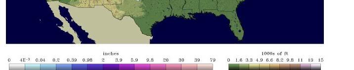


4 Snow Water Equivalent Jan 27, 2009 Snow Water Equivalent Feb 2, 2009 NOAA National Snow Analysis Snow Depth Feb 2, 2009 Snow Melt 24 hr period ending Feb 2, 2009
 Large temp differences between cp & mt air masses - strong winds Winds up to 70-80 mph Iowa - Jan mean temp = 20F Iowa - 32 inches")
5 Winter What physical conditions o cause winter? Tilt of earth Shorter days (Solstice Dec 21 9 hours of daylight) Low solar angle (Solstice 24.5 degrees above the horizon at noon) Large temp differences between cp & mt air masses - strong winds Winds up to mph Iowa - Jan mean temp = 20F Iowa - 32 inches annual snow = 3 in of water


, settled snow >30% Snow plastic bends &")


6 Snow is unique Why? Frozen, delivered under strong influence of wind & surface friction Stored as snow pack air with a little water; glacial ice water with a little air Fresh fluffy snow 8-10% water (10 snow = 1 water), settled snow >30% Snow plastic bends & bridges under gravity & melting allows hollow cavities where small animals can travel Reflects (up to 90% fresh; old 40%) Insulates transmits heat at about the same speed as dry wood X slower than rock, 10-20X slower than wet sand


 Energy Wind Plants are in two media")
7 Organism Adaptations What kind of changes do they have to adapt to? Means & extremes of temp, wind, snow, etc. Timing, duration, frequency of occurrence Seasonality differences between summer & winter strong criteria i Repeatability in a life-time Organisms must respond to: Snow Cold Radiation (SCREW) Energy Wind Plants are in two media with different conditions


8 What different ways do animals cope? Changing body mass & fat Changing social structure - herding Selecting/ creating favorable microhabitats Entering dormant state t of torpor short periods of slow down Hibernating up to 9 months of reduced metabolism Migrating


9 What are differences in over-wintering strategies of conifers & deciduous trees & herbaceous plants? What are differences in two media that perennial plants exist in?


10 Two Environments Density, Movement & O 2 of Medium High Density Low Density Low Oxygen Moderate Temps Slow Temp Change High Wind Temperature of Medium Moisture of Medium Moist to Saturated or Frozen Extreme Temps Rapid Temp Change Very Dry Page 1
11 Watersheds/Drainage Basins
12 Gilbert Corner X X X Soper s Mill Access Ada Hayden
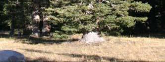
13 Soil Map X Open Grown Oaks X Floodplain X Get out Snow deposition Wind effects X Large Depression (black center)
14 X X X Soper s Mill Access Skunk River Greenbelt


15
16 Hillslope Soils Hayden-Lester-Storden Association Parent Materials Glacial Till, Bedrock, Colluvium, Alluvium Hayden 168 shoulder, upper back slope, well-drained loam, formed under forest Lester 236 summit, shoulder, welldrained, loam, formed under savanna vegetation Storden 62 back slope, shallow loam, well-drained, formed under forest Terril 27 foot slope, well-drained loam, formed under forest Coland 135 foot slope, poorly drained Clay loam along small creeks
17 Flood Plain Soils Along the Skunk River Coland-Spillville-Zook Soil Association Flood Plain- Toe Slope Spillville 485 black loam, moderately well drained Coland 135 black clay loam, poorly drained Parent Material Alluvium Zook 54 black silty clay loam, poorly drained Hanlon 536 (1314) natural levee, sandy loam Wadena & Biscay - minor soils


18 Hayden Hayden 9-18% 18% Hayden Hayden 5-9% 9% Hanlon Hanlon Spillville Spillville 0-2% 2% Hayden Hayden 2-5% 5% Hayden Hayden Forest Forest 9-18% 18% Hayden Hayden Lester Lester Savanna Savanna 5-9% 9% Hayden Hayden Storden Storden Forest Forest % 50% 5 9% 9% Lester Lester 9-14% 14% Hayden Hayden 2 5% 5% Lester Lester 2-5% 5% 2-5% 5%
19 Soper s Mill Access in the Skunk River Greenbelt

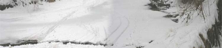


20 Skunk River Upstream Skunk River Downstream
21
22 Concave Watershed Convex Valley Components Slope Components Valley and Slope Components
23
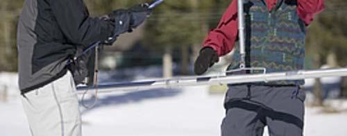
24 Teams use flags mark breaks between: a) summit/shoulder b) shoulder/backslope c) backslope/toeslope d) toeslope/footslope 2. Use clinometer to determine slope, compass aspect 3. Meter stick to measure snow depth & estimate inches of water (10:1) Teams 1-6 walk & mark contours Skunk River


25 Going to compare: Aquatic, bottomland (riparian) and upland terrestrial ecosystems Questions: 1. Where is the water? 2. What state is it in? 3. How fast is the water moving? 4. How much energy is available for heating air & soil, melting snow moving water & warming plants & animals role of topography 5. What effect does the water have on macro & micro climate? 6. What effect does it have on the plants and animals? 7. How could one manage sites to maximize snow catch 8. How might climate change influence snow


.")
26 Assignment: Short piece for a Wikapedia limited by space Four topics each team member writes one section A section is limited to words Sections need to transition from one to the other Each member will edit whole paper Due one week from Thursday (Feb 12). Vans are Outback BRRR!