The National Cooperative Soil Survey Program when complete. will have produced soil survey reports for all counties in the
|
|
|
- Andra Gaines
- 5 years ago
- Views:
Transcription
1 METHODOLOGY FOR ON-SITE SOIL ANALYSIS Barrett L. Kays Soil Scientist/Landscape Architect Sunbelt Planning Associates, Inc. Raleigh, North Carolina ABSTRACT -- Soil surveys in urban areas generally will provide 1ittle more than a map of the pre-urban soils. For this reason urban sites that have been altered need more detailed on-site investigations. There is a two-level approach to on-site investigations, each one requiring a different array of sampling and testing procedures. USE OF SOIL SURVEYS The National Cooperative Soil Survey Program when complete will have produced soil survey reports for all counties in the United States. Although the surveys are designed around agricultural parameters, they can be useful in urban areas if their applicability is understood. Formerly, urban areas were mapped simply as urban land. Now, it is common for the soil surveys to use "urban soil complexes" (soil name) which denotes the pre-urban soil and recognizes the fact that the soils have been significantly altered. Few soil surveys (an example is the Soil Survey for the District of Columbia) actually have mapped disturbed soils, usually termed Orthents. In general, soil surveys in urban areas will provide little more than a map of the pre-urban soils. For this reason, urban sites that have been altered need to receive more detailed on-site investigation. In 7-1
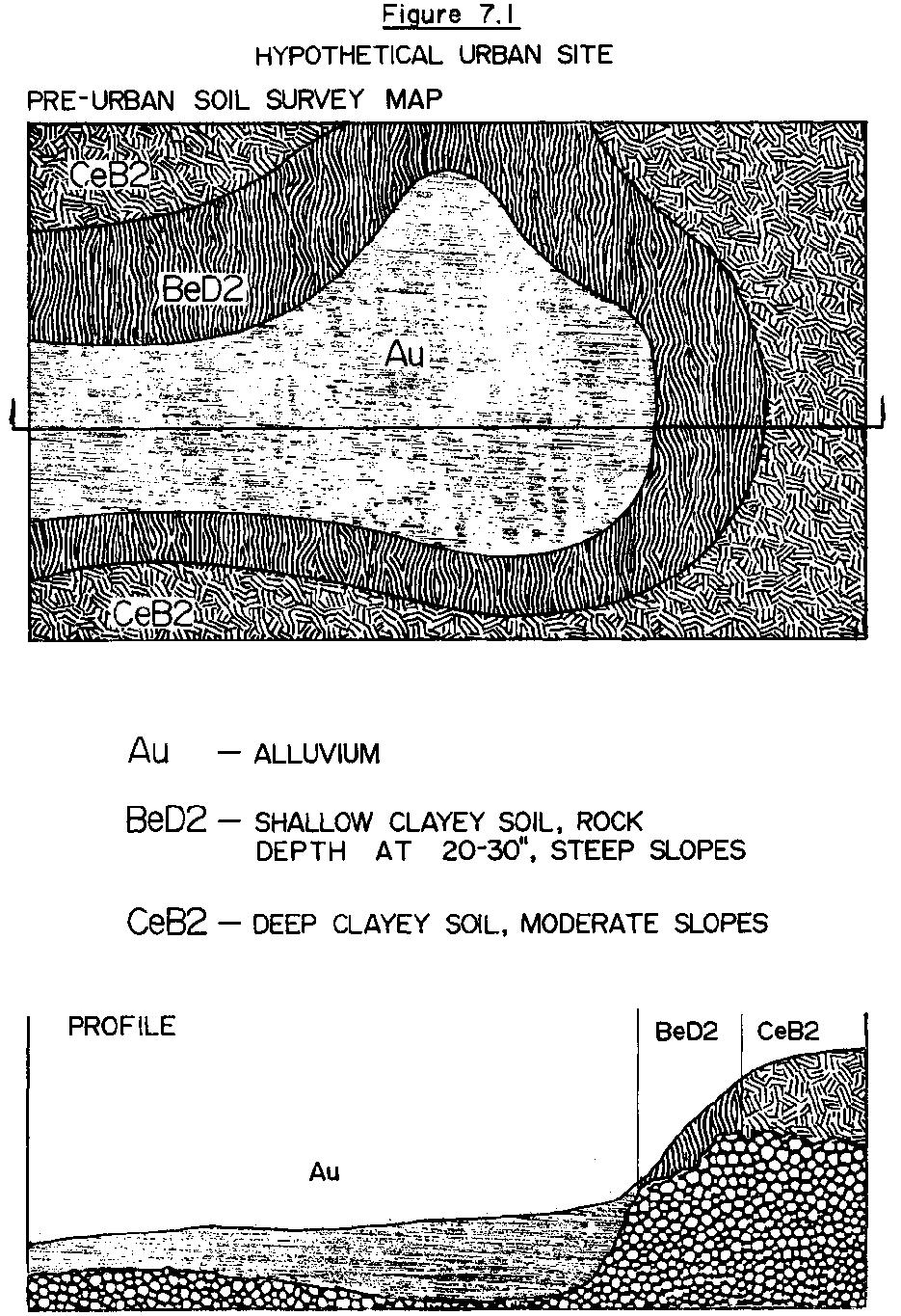
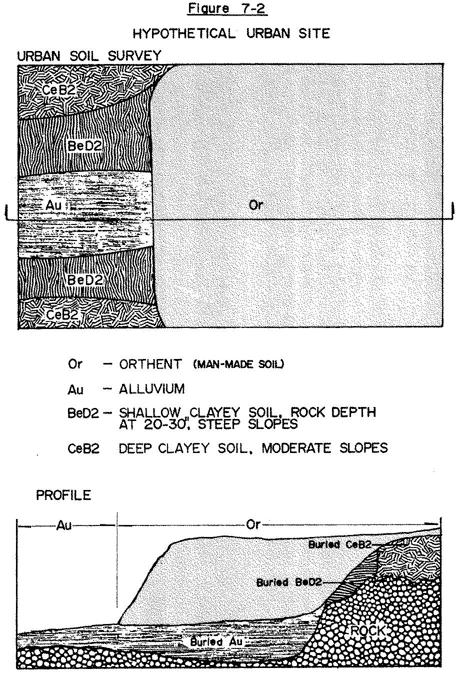
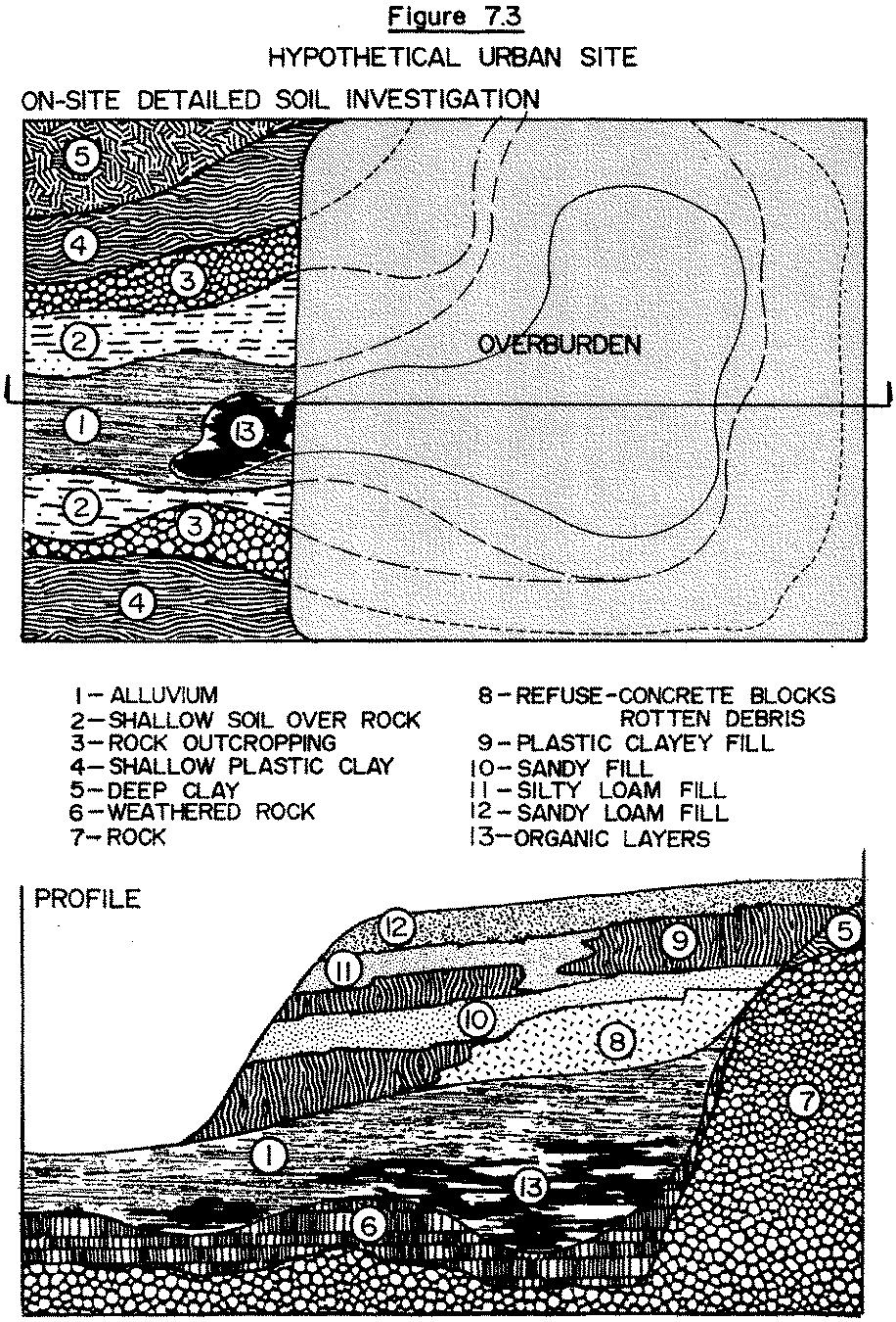
2 addition, these county soil surveys are not site specific and the information relates to only the upper three feet or so of the soil profile. TYPES OF ON-SITE SOIL INVESTIGATIONS Figure 7.1 illustrates the standard county soil survey map of a hypothetical site prior to urbanization. Figure 7.2 illustrates how the county soil survey normally would indicate the site after major urban man-made soil alterations have occurred; only limited new information is given. Figure 7.3 illustrates a portion of the extensive amount of information that can be gained with a detailed soil investigation. Detailed on-site soil investigation requires that numerous hand or power-driven borings be conducted. Hand auger borings can be used for depths of less than 20 feet. Their use will depend upon the soil materials present and difficulty of digging. Hand auger borings require hard manual labor and will be most difficult if not impossible on sites with compacted heavy soil materials. However, hand auger borings are less expensive than power-driven borings. There are three basic types of power-driven borings: flight augering, hydraulic coring and drive sampling. Flight augering is a rotating drill method that cuts and worms out more or less continuous ribbons of the soil material. This method is especially useful for visual investigations. The boring proceeds quickly allowing for more holes to be drilled per unit time than 7-2
3 7-3
4 7-4
5 7-5
6 other methods. The disadvantage is that undisturbed soil samples cannot be taken with this method. However, the method is useful for site mapping and to determine the best locations to take undisturbed samples. Hydraulic coring involves hydraulically forcing a sampling tube into the ground. The tube can be withdrawn in sections, allowing for removal of partial or complete sections of the soil. The "undisturbed" sample can be extruded or can remain in the tube for laboratory tests, such as permeability. The degree of compaction of the soil can be determined by the resistance to penetration. The drive sampling method using a split-tube sampler is a common procedure by soil engineering firms. A standard 140-pound hammer is used to drive the sampler into the ground. The number of blows per foot is recorded as a measure of penetration resistance. The soil core can be extruded from the sampler. The pounding of the hammer tends to disturb the sample more than the hydraulic coring method. Selecting the appropriate number, type, depth and location of the samples takes experience and good judgment. It is best to consult a soil scientist or a firm specializing in soil investigations for landscape applications. Most soil engineering firms are not experienced in soil investigations for landscape purposes and will need special directions and assistance. 7-6
7 ORGANIZING ON-SITE SOIL INVESTIGATIONS There is no simple method to determine what needs to be accomplished in a detailed soil investigation. The nature and scope of the investigation will depend upon the site characteristics, the proposed use, the available financial funds and the knowledge of the landscape architect and/or engineer. In many situations it is useful to conduct preliminary investigations (Level 1) on the site with a hand auger to help better define the necessary extent and type of detail investigations. Soil investigations for landscape planning are in essence the search for potential problems and then determining appropriate solutions. The problems can be classified as chemical, physical or morphological. Table 7.1 provides an outline of many common soil characteristics and indicates when potential landscape problems may exist. The list is useful for checking potential problems during the preliminary investigations (Level 1) and then selecting appropriate tests to be conducted during detailed investigations (Level 2). This twolevel approach is strongly recommended. If no significant problems are encountered at the preliminary level, then only simple, routine fertility tests might be required at the second level, thus saving time and expense. Therefore, the preliminary investigations are quite important. Your solution to soil 7-7
8 Level 1 Preliminary Investigations: Level 2 Detailed Investigations Identification of Potential Problems Recommended Testing if Moderate or Soil Characteristics Moderate Severe Severe Problems Occur at Level 1 Morphological Depth to rock Depth to seasonally <4 feet <4 feet <2 feet <2 feet Numerous borings; also determine effect upon water table Numerous borings; determine reason(s) for shallow water High water table Depth to apparent <6 feet <4 feet table; collect date for drainage design Numerous borings; determine reason(s) for shallow water Water table table; collect date for drainage design Depth to restrictive Horizons <4 feet <2 feet Numerous borings; determine nature and permeability of restrictive horizon; determine effect upon water table Soil structure Massive yes yes Conduct infiltration and subsoil permeability tests Platy yes yes Conduct infiltration and subsoil permeability tests Physical Soil texture Sand >75% >90% Laboratory soil texture; determine drainage rates for Irrigation design Clay, Kaolinitic >50% >65% Laboratory soil texture; check structure and bulk density Clay, Expandable any >10% Laboratory soil texture; infiltration and permeability tests Clay and Silt Soil permeability >50% <0.25 in/hr >75% <0.05 in/hr Laboratory soil texture; infiltration and drainage rates Determine permeability of important horizons; collect Data for drainage design Bulk density clay dense (>1.4 g/cm 3 ) dense (>1.5 g/cm 3 ) Determine soil porosity, infiltration and subsoil permeability - loam dense (>1.6 g/cm 3 ) dense (>1.8 g/cm 3 ) Determine soil porosity, infiltration and subsoil permeability Chemical ph Fertility * * * * Check ph in rooting zone Check phosphorous and potassium levels in rooting zone Lime requirement Salinity ph <6 ph >8 ph <5 ph >9 Laboratory analysis for lime requirement Laboratory analysis for salinity TABLE ON-SITE SOIL INVESTIGATIONS METHODOLOGY *Can be checked with field soil testing kit, however it is recommended to also send samples to laboratory for testing. Appropriate determination of moderate and severe; good judgment is required.
9 management on the site will depend upon how well you recognize and work with the site problems and assets. If you are not experienced in soils, hire a consulting soil scientist, soil engineer or use an agricultural extension soil specialist for the preliminary investigation. If you have soil problems, the consultant can assist you in planning detailed investigations. SOIL SAMPLING METHODS Many soil properties will have significant spatial (vertical and lateral) variations. Different soil properties will require different sampling approaches. Borings can be conducted spatially on a grid basis, but more commonly, boring locations are controlled by placing more borings in the areas of most interest; for example, locating more borings along a major soil boundary to better locate it spatially, or locating more borings in an area of potential landscape problems. Often soil samples for chemical or physical determinations are made on an area-wide basis. Samples are collected over the area and combined to produce one bulk sample. This is a common technique for fertility tests and for an average particle size analysis. The samples are gathered from each important soil horizon. Another technique for many physical determinations is to cluster samples. This is done for properties that have a 7-9
10 large micro-heterogeneity and small macroheterogeneity. Infiltration tests, for example, are commonly run in triplicate at each location, while six to twelve undisturbed soil cores are required from each horizon at each location to adequately determine water movement properties in the laboratory. Therefore, more samples are collected at each location and a fewer number of cluster locations are used because of the type of heterogeneity. Determining the appropriate location number and type of samples will require special assistance. However, with a little studying and good back-up assistance, the landscape architect can handle the vast majority of the sampling for many common problems in his area. Samples can be sent to a laboratory for analysis and results returned to aid in making soil management decisions and designs. A list of useful reference documents is provided. 7-10
11 REFERENCES Black, C. A. (Ed) METHODS OF SOIL ANALYSIS. PART I. PHYSICAL AND MINERALOGICAL PROPERTIES. INCLUDING STATISTICS OF MEASUREMENT AND SAMPLING. Amer. Soc. Agron., Inc. Madison, Wisconsin. Black, C. A. (Ed.) METHODS OF SOIL ANALYSIS, PART II, CHEMICAL AND MICROBIOLOGICAL PROPERTIES. Amer. Soc. Agron., Inc., Madison, Wisconsin. Dunne, T. and L. B. Leopold WATER IN ENVIRONMENTAL PLANNING: CHAPTER 6 - WATER IN SOIL; CHAPTER 7 - GROUNDWATER. W. H. Freeman and Company, San Francisco, California. Gee, G. W., et al PHYSICAL ANALYSES OF OVERBURDEN MATERIALS AND MINE LAND SOILS, CHAPTER 38 IN RECLAMATION OF DRASTICALLY DISTURBED LANDS. Amer. Soc. Agron., Inc., Madison, Wisconsin. Johnson, A. I A FIELD METHOD FOR MEASUREMENT OF INFILTRATION. U.S. Geological Survey Water Supply Paper 1544-F, USGPO, Washington, D.C. Soil Survey Staff SOIL SURVEY LABORATORY METHODS AND PROCEDURES FOR COLLECTING SOIL SAMPLES. USDA, SCS, Report 1, USGPO, Washington, D.C. Soil Survey Staff SOIL SURVEY MANUAL, USDA Agri. Handbook 18, USGPO, Washington, D.C. 7-11