Land and Water Management Division Programs. Department of Environmental Quality
|
|
|
- Simon Sanders
- 5 years ago
- Views:
Transcription
1 Land and Water Management Division Programs Department of Environmental Quality

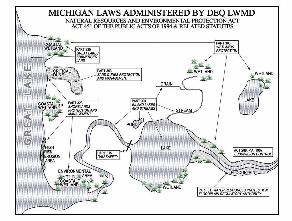
2 Land and Water Management Programs Since the mid-1970 s, special resources that exist at the interface between land and water have been protected by programs in the Division.
3 These programs are based on several state laws enacted between 1955 and 1989 which are now codified as the following parts of the Natural Resources and Environmental Protection Act: Part 31 Floodplain Management Part 301 Inland Lakes and Streams Part 303 Wetlands Protection Part 315 Dam Safety Part 323 Shorelands Protection and Management Part 325 Great Lakes Submerged Lands Part 353 Sand Dune Protection and Management
4 In conjunction with these programs, the Division also administers the following parts of the Natural Resources and Environmental Protection Act: Part 35 Use of Water in Mining Low-Grade Ore Part 307 Inland Lake Levels Part 311 Local River Management Part 313 Surplus Waters Part 326 Great Lakes Submerged Logs Recovery Part 339 Control of Certain State Lands (St. Clair Flats) Part 341 Irrigation Districts Part 761 Aboriginal Records and Antiquities Act 288 Subdivision Control (floodplain plat reviews)
5
6 Part 31, Water Resources Protection (Floodplain Regulatory Authority) Reduces flooding through regulation of activities in floodways and a floodplains. What is a Floodplain? That area of land adjoining a river or stream that will be inundated by a 100- year flood. 100-year flood is: A flood with a magnitude which has a 1 % chance of occurring or being exceeded in a given year.


7 Floodway and Floodplain Area of inundation Area of active flow.
8 Floodplain Regulations State: Part 31 of Public Act 451 Local: Building Codes, Zoning and Floodplain Management Ordinances Federal: National Flood Insurance Program

9 Floodplain Maps 500-Year Floodplain 100-Year Floodplain Flood Elevation Floodway

10 A Permit is required under Michigan s floodplain law for the following activities: Any Occupation, Any Filling, Any Grade Changes within the floodplain of a river


11 2002 Flooding City of Wakefield Dead River


12 Part 301, Inland Lakes and Streams Protects inland waters by regulating work in inland lakes and streams. What is a lake? Surface Area GREATER than 5 acres Natural or artificial lake, pond, or impoundment DOES NOT include the Great Lakes, Lake St. Clair, or a lake or pond that has a surface area of less than 5 acres.

13 Part 301, Inland Lakes and Streams Protects inland waters by regulating work in inland lakes and streams. What is a Stream? Any other body of water that has definite banks, a bed, and visible evidence of a continued flow or continued occurrence of water A river, stream, or creek which may or may not be serving as a DRAIN as defined by the drain code of 1956, 1956 PA 40, MCL to ; INCLUDES the St. Marys, St. Clair, and Detroit rivers.


14 Michigan has over 36,000 miles of streams, and more than 11,000 lakes and ponds, providing fish and wildlife habitat, and recreational opportunities.
15 Part 301 Regulated Activities Dredge or fill bottomland. Construct, remove, or place a structure on bottomland. Erect, maintain, or operate a marina. Create, enlarge, or diminish an inland lake or stream. Structurally interfere with the natural flow of an inland lake or o stream. Construct, dredge, commence, extend, or enlarge an artificial canal, channel, ditch, lagoon, pond, lake, or similar waterway where the purpose is ultimate connection with an existing inland lake or stream, or where any part of the artificial waterway is located within 500 feet of the ordinary high-water mark of an existing inland lake or stream. Connect any natural or artificially constructed waterway, canal, channel, ditch, lagoon, pond, lake, or similar water with an


16 Some of the types of projects the Division reviews include: Boat ramps Bridges and culverts Buildings in regulated areas Dams Dredge and fill Marinas Permanent structures in regulated areas Ponds Shoreline protection Streambank stabilization Bridge construction

17 Part 303, Wetlands Protection Protects wetland functions and values by requiring permits for activities within wetlands. What is a wetland? Wetland means land characterized by the presence of water at a frequency and duration sufficient to support, and that under normal circumstances does support, wetland vegetation or aquatic life, and is commonly referred to as a bog, swamp, or marsh. Wetlands are regulated if: Connected to or located within 1,000 feet of one of the Great Lakes or Lake St. Clair. Connected to or located within 500 feet of an inland lake, pond, river, or stream. More than 5 acres in size The DEQ has determined that the wetland is essential to the preservation of the state's natural resources.


18 Wetlands serve as fish and wildlife habitat by providing breeding, nesting, and feeding areas.


19 Wetlands reduce shoreline erosion. And Help Protect Water Quality by: -Intercepting surface runoff -Removing/retaining nutrients -Processing organic wastes -Reducing suspended sediments.


20 Wetlands prevent property damage and stabilize water flows by storing and slowly releasing water, rain, snowmelt, groundwater and floodwaters.


21 Part 303 Regulated Activities Deposit or permit the placing of fill material in a wetland. Dredge, remove, or permit the removal of soil or minerals from a wetland. Construct, operate, or maintain any use or development in a wetland. Drain surface water from a wetland


22 Some of the types of projects the Division reviews include: Buildings in regulated areas Dredge and fill Permanent structures in regulated areas Ponds Shoreline protection Shoreline vegetation removal

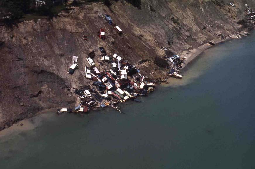
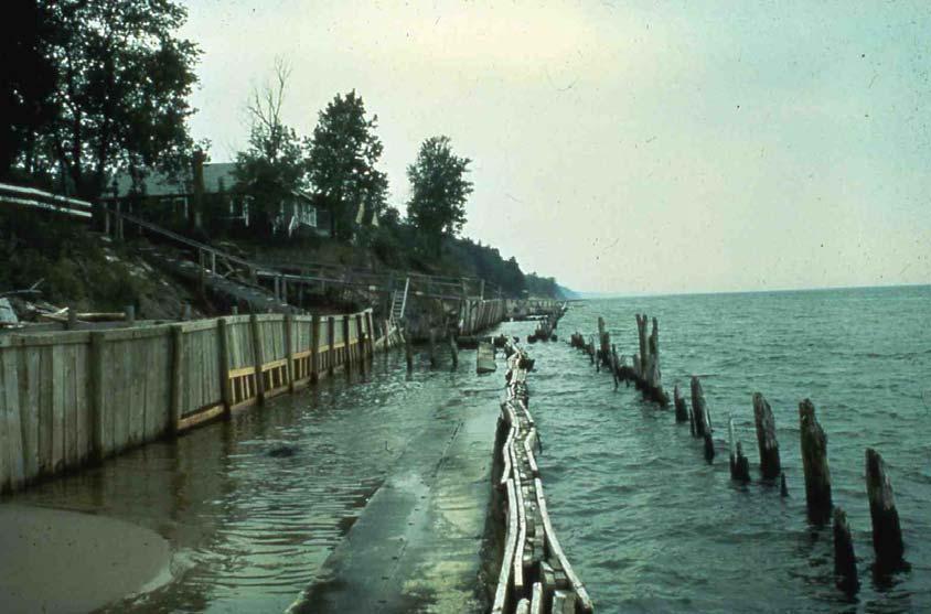
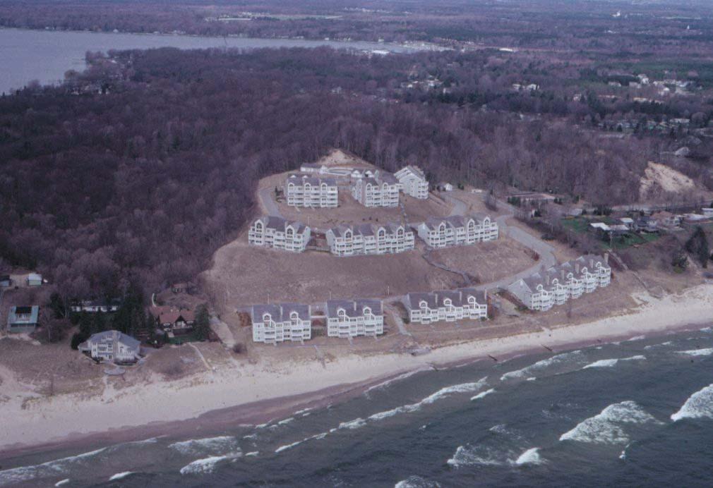
23 Part 315 Dam Safety What is a dam under Part 315? An artificial barrier, including dikes, embankments, and appurtenant works, that impounds, diverts, or is designed to impound or divert water or a combination of water and any other liquid or material in the water; that is or will be when complete 6 feet or more in height; and that has or will have an impounding capacity at design flood elevation of 5 surface acres or more.
24
25 Ownership Type Fed, 4.43% Local Gov't, 12.8% DNR, 21.3% Private, 61.5%


26 The purpose of the Dam Safety Program is to protect the public from dam failures. Tourist Park Dam, Marquette

27 Activities Requiring Part 315 Permits Construction of a new dam. Enlargement of a dam or an impoundment. Repair of a dam. Alteration of a dam. Removal of a dam. Abandonment of a dam. Reconstruction of a failed dam.

28 Additional Requirements Periodic Dam Inspections Corrective Action Required for Problem Dams Emergency Action Plans Dead River flooding caused by dam failure
29 Since the statute was passed in 1990, dam failures have greatly decreased. Michigan Dam Failures # of Incidents 's 1980's 1990's 2000's Years 6


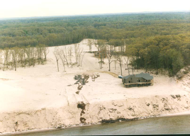
30 Part 323, Shorelands Protection and Management Identifies high-risk erosion and environmental areas along the Great Lakes shoreline and regulates development in these areas.
 is an area of shoreline that is determined on the")
31 What is a High Risk Erosion Area? A High Risk Erosion Area (HREA) is an area of shoreline that is determined on the bases of studies and surveys to be subject to erosion.

32 What is an Environmental Area? An Environmental Area is an area of the shoreline determined on the basis of studies and surveys to be necessary for the preservation and maintenance of fish and wildlife.
33 Building on Regulated Property For a property designated as HREA, a permit is required to: - erect, install, or move a permanent structure. - install or replace a septic system. - construct an addition to an existing structure. - make substantial improvements to existing structures. For a property designated as an Environmental Area, a permit is required for: - dredging, filling, grading, or other alterations of the soil. - alteration of natural drainage. - alteration of vegetation utilized by fish or wildlife, or both.

34 Part 325, Great Lakes Submerged Lands Protects our Great Lakes resources by regulating development below the ordinary high-water mark.

35 There is approximately 3288 miles of Great Lakes shoreline in Michigan. Part 325 protects the Great Lakes and Lake St. Clair, but not the connecting waters such as the St. Mary s River or Detroit River. Part 325 protects the public trust, riparian rights, and the environment.
36 Why regulation is necessary


37 Permits are required for: Dredging Connecting a canal, ditch, lagoon, or similar waterway to the Great Lakes or Lake St. Clair Filling or construction on bottomlands Construction or expansion of marinas Removal of shoreline vegetation

38 Part 325 Regulates the Conveyance of Public Trust Leases for marina purposes Bottomlands Public or Private use agreements Deeds Drummond Island Marina has a lease and deed

39 Part 353, Sand Dune Protection and Management Protects critical dune areas Public Act 222, Sand Dune Protection and Management Act was enacted. 275,000 acres designated as Sand Dune Areas Regulations applied only to sand mining

40 In 1989, the Michigan legislature amended the Sand Dunes Protection and Management Act. These amendments broaden the scope of the original act to include regulation of residential, commercial and industrial development in designated critical dunes; this is now Part 353. The critical dune areas of this state are a unique, irreplaceable, and fragile resource that provide significant recreational, economic, scientific, geological, scenic, botanical, educational, agricultural, and ecological benefits to the people of this state
 CDA are mapped in the")
41 70,000 acres were designated as Critical Dune Areas (CDA) CDA are mapped in the atlas
42 Why the Regulations are Necessary

43 Regulated Activities Permits are required for: All construction. Installation of septic systems and water wells. Vegetation removal. All terrain alteration activities.


44 Construction and other activities that impact aquatic resources often fall under more than one of these authorities. Inland lakes and streams Wetland Protection


45 High Risk Erosion Areas Critical dune areas. Great lakes submerged lands


46 Floodplain regulation Dam Safety


47 Part 761 provides for protection of antiquities such as shipwrecks on Great Lakes bottomland. Part 339 provides for leasing of platted lots in St. Clair Flats.
48 LWMD s Hydrologic Studies Unit Hydrologic Data Collection & Analysis Collect Streamflow Measurements Calculate Flood Discharge Estimates Calculate Drought Flow Estimates Floodplain Mapping Provide Hydrologic Support for the Nonpoint Source Program and other DEQ programs
49 Hydrologic Studies data: For in-stream structures, such as bridges and dams, flood discharge estimates are used to size structures to ensure they can safely pass the design flood. For structures outside of the stream, such as houses and commercial development, flood discharges are used to determine the extent of the floodplain to ensure the structures are constructed with a minimal risk from flooding. Floodplain boundaries are mapped in partnership with the Federal Emergency Management Agency throughout the state.
50 Land and Water Management Division s Permit Application Process

51 Joint Application and Federal Assumption The Division pioneered the use of a single, consolidated permit application in Permit applicants now provide a single application to the Division, and staff provide a simultaneous review under all pertinent authorities.
52 Michigan was the first state in the country, and remains one of only two states, to receive approval to administer the Federal Section 404 Permit Program. Because of this authorization, permits issued by the DEQ also provide authorization under Section 404 of the Federal Clean Water Act (except in coastal areas where federal law does not authorize Section 404 assumption).

53 Applicants for dredge and fill permits under Inland Lakes and Streams and Wetland Protection do not generally need a separate federal permit from the U.S. Army Corps of Engineers, as they would in most states.
54 Michigan currently authorizes about 5,000 projects annually under Section 404, providing the citizens of the state with a significant savings in time and cost. While the U.S. Environmental Protection Agency continues to oversee Michigan s Section 404 Program, it directly reviews only about 1 to 2% of the largest permit applications received each year.
55 The EPA also evaluates Michigan s laws and regulations to ensure that the Section 404 program is operated in a manner that is consistent with federal law. Should Michigan s program fail to maintain federal consistency, a return to separate state and federal permitting would be required.
56 Michigan s permit program combines multiple state and federal authorizations under one permit application, although the process is so seamless that most applicants are likely to be unaware of the multiple issues addressed by the process. In many states, separate authorizations are required for each of these processes.
57 A permit issued by the Division typically carries with it the following authorizations, at no additional expense to the applicant: Authorization under Section 404 of the Federal Clean Water Act Water Quality Certification under Section 401 of the Clean Water Act Coastal Zone Consistency Certification Screening and coordination with state and federal endangered species programs Screening and coordination with the federal historic preservation program
58 Many of the LWMD programs require the DEQ to notice pending applications: Public notices are sent to: Adjacent riparians or property owners Local governments (Township/City Clerk, County Clerk, County Drain Commission, County Health Department, County Soil Conservation District) DNR Wildlife and Fisheries Divisions State Historic Preservation Office
59 If a special interest is identified in our database, then files are also copied to other agencies for review: Natural Heritage Program/Endangered and threatened species review State Historic Preservation Office DEQ: RRD, WB, WHMD, Great Lakes DNR Natural Rivers Environmental Protection Agency (EPA) Army Corps of Engineers Watershed Councils Farmlands and Open Space (P.A. 116)
60 In accordance with the State s 404 Program agreement, files that meet the following require a 90-day EPA review: Fills > 10,000 cubic yards Seawalls >1,000 feet Culvert enclosures > 100 feet Stream relocations > 500 feet Critical areas established by State & Fed. Law Federal listed endangered/threatened species Known or suspected toxic pollutants The agreement also allows EPA to request review of any file.

61 A copy of a Public Notice and the status of all permit applications is available to the public at
62 Permit Decisions When the file is received at the district office, the staff person assigned to that county: Conducts a site review. Reviews comments received on the file. Conducts a public hearing if requested. Reviews project according to all applicable statutory criteria and completes the Project Review Report. Works with applicant and his/her engineers, consultants, attorney on any needed modifications to comply with statutory criteria. Discusses/negotiates permit conditions required to minimize and mitigate any natural resource impacts.
63 Staff use permit review criteria established by statute to weigh the public benefits provided by the resource against the benefits of the proposed project. Some of these criteria include: The permit must be in the public interest (Part 303). No unacceptable disruption to the aquatic resource will occur (Part 303). No adverse impact to the public trust or riparian rights (Part 301). The benefits derived from alteration shall occur only when the protection of the environment and ecology for the benefit of present and future generations is assured (Part 353). No harmful interference with the discharge and stage characteristics of streams (Part 31). The project will not injure the public trust or interest including fish and game habitat (Part 325). The activity is otherwise lawful (Part 303 and 301).
64 Types of Decisions: 1. Permit Issued as proposed: Conditions can be added to lessen the impacts, mitigate for the impacts, or monitor impacts. (~69%) 2. Permit Issued for a modified project: Division negotiates with the applicant to modify the project to lessen impacts. (~17%) 3. Permit Denied: A Permit is denied if the project does not meet statutory requirements, staff may suggest an alternative. (~2%) Withdrawn applications account for ~ 11%.
65 Appeals Process An applicant or third party can administratively appeal a decision made by the LWMD. These appeals can be settled through an informal negotiation process (~90%) or through contested case hearing before an Administrative Law Judge (~10%). The Administrative Law Judge oversees the hearing process and recommends a Decision to the DEQ Director. The DEQ Director makes a final decision based on the administrative record. Final decisions can be appealed to Circuit Court.
66 Duties of LWMD staff include: Permit application review (~6000/yr). Walk-in assistance to permit applicants. Phone calls (~250,000/yr). Respond to violation complaints (~3200/yr). Permit compliance inspections. Provide assistance to local governments. Wetland Identification Program (~330/yr). Presentations to realtors, schools, lake associations, contractors, and developers.
67 Duties of LWMD staff include (cont.): Training and guidance for staff to improve consistency in the program. Workshops on the permit application process (~600 citizens and consultants trained last year). Responses to correspondence and inquiries from the legislature, public, regulated community, and environmental groups. Public hearings (~70 last year). Marina operating permits (~300/yr).
68 Duties of LWMD staff include (cont.): Pre-application meetings. Coordinate and promote the wetland mitigation banking program. County assistance visits for National Flood Insurance Program (NFIP). NFIP workshops for local officials (~15/yr) Developing educational materials and web pages for applicants and the general public. Meetings and on-site field inspections with Transportation officials (~420/yr).
69 Duties of LWMD staff include (cont.): Great Lakes shoreland recession studies to determine high risk erosion areas. Court appearances. Review proposed subdivisions for floodplains (~150/yr). Inspect state and municipal dams (~70/yr). Hydrologic calculations for NPDES permits (~350/yr) and flood discharges (~1100/yr). Hydraulic reviews for structures in floodplains (~450/yr).
70 Duties of LWMD staff include (cont.): Conservation easement coordination. Develop methods to provide information on-line. (For example: Permit application status and public notices are available on-line.) Provide regulatory assistance to other state and federal agencies.
71 Summary: 15 statutes. 83 counties. 3,288 miles of Great Lakes Shoreland. 11,000 inland lakes. 36,000 miles of streams. 2.2 million acres of floodplain 5.5 million acres of wetland (ca.1990) 2,400 dams. The demands on LWMD staff to provide the public with the quality of service they desire, and require, exceed current resources.

72