Globeville Landing Outfall Surface Water. December 12, 2017 Andrew Ross, Jon Novick Denver Department of Public Health & Environment
|
|
|
- Philip Patrick
- 5 years ago
- Views:
Transcription
1 Globeville Landing Outfall Surface Water December 12, 2017 Andrew Ross, Jon Novick Denver Department of Public Health & Environment
2 Introductions Andrew Ross Environmental Program Manager, DDPHE Jon Novick Water Quality Program Manager for DDPHE Oversees Denver s monitoring and reporting Developing plans for long-term monitoring
3 Contents What is surface water? Where does it go? How is surface water regulated? CAG Questions Surface water quantity at GLO before and after GLO? Surface water quality at GLO before and after GLO? South Platte River water quality? Long-term monitoring? Where can I get more information? Questions and Answers
4 Surface Water Sources Large majority runoff from rain and/or snow Some from irrigation run-off (dry weather flow) Some from groundwater (dry weather flow) Drains through streets and storm sewers to river
5 Surface Water Quantity


6 Local Geology

7 Regional Surface Water Flow
8 Surface Water Flow Before GLO Construction


9
10 CAG Questions Surface Water Quantity How does basin storm water get to the South Platte River? Current: Globeville Landing Park existing channel via 40 th & Blake pipe 38 th Street Outfall RTD drainage Smaller outfalls Overland and street flow Trans-basin spillage/flow during major events Existing system has approximately 39% of 100 year flow capacity (will carry between 2 and 5 year flood.) Future Location 2 Year 10 Year 100 Year Globeville Landing Outfall after construction 1150 cfs 1740 cfs 3750 cfs

11 South Platte Storm Flow 4500 South Platte River at 18th Street September Flow CFS /1/2013 9/6/2013 9/11/2013 9/16/2013 9/21/2013 9/26/ /1/2013
12 CAG Questions - Surface Water Quantity Flow volumes are monitored in the South Platte River No routine flow monitoring is done on the storm sewer conveyance system What information is available? South Platte River flow volumes: Platte to Park Hill: Stormwater master planning:

13 Surface Water Quality
14 CAG Questions Surface Water Quality, South Platte River What do we know about the quality of existing surface water passing through GLO? What information is available regarding S. Platte River quality? What is monitored? Where? Frequency? What do these data tell us? What about downstream water users? What will be monitored in the future? What information is available?
15 Water Quality Regulation How is surface water regulated? Clean Water Act gives EPA authority to protect streams and lakes (usually authority then is delegated to states) Permits containing standards and limits issued by CDPHE, some local Discharge must be safe for human health and aquatic life Businesses must prevent impacts from storm water collected on their properties (permits required) Cities must manage storm water drainage collected from homes, streets, and industrial discharges (permits required) Larger construction projects must prevent impacts from storm water running across construction site (permits required)
16 DDPHE Water Quality Program The South Platte-Cherry Creek confluence sampled weekly, May-October and twice a month the rest of the year Bear Creek at the picnic shelter in Bear Creek Park sampled weekly May through October Sloans Lake sampled every other week, May-October Westerly Creek near the playground in great Lawn Park sampled once or twice a month from May to October Berkeley and Rocky Mountain Lakes sampled monthly from May to October A number of other sites on the South Platte River and Cherry Creek are sampled monthly and sites on Bear Creek are sampled once a quarter year-round.

17 DDPHE Monitoring Locations
18 DDPHE Stream Sampling Pathogens E. coli Metals Arsenic, Cadmium, Calcium, Chromium, Copper, Iron, Lead, Magnesium, Manganese, Mercury, Molybdenum, Nickel, Potassium, Selenium, Silver, Sodium, Uranium, Zinc Inorganics Alkalinity, Chloride, Hardness, Oil and Grease, ph, Specific Conductance, Sulfate, Temperature, Total Dissolved Solids, Total Suspended Solids Nutrients Ammonia, Nitrite, Nitrate, Kjeldahl Nitrogen, Dissolved Oxygen, Phosphorus, Organic Carbon
19
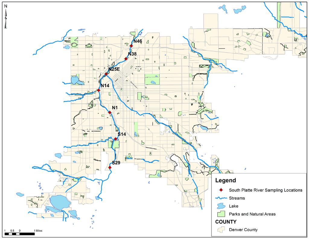
20 South Platte River Sample Sites and Analytes for Discussion S29: South Platte downstream of Dartmouth N38: South Platte at 38 th Street, upstream of GLO N46: South Platte at 46 th Street, downstream of GLO Total Arsenic, Dissolved Lead, Nitrate, E. coli

21
22 Total Arsenic South Platte River 2016 & Total Arsenic ug/l S29 Result N38 Result N46 Result SDWA Standard Temporary Water Supply Standard
23 Dissolved Lead South Platte River 2016 & Dissolved Lead ug/l S29 Result N38 Result N46 Result Aquatic Life Standard
24 Nitrate South Platte River 2016 & 2017 Chart Title 10 8 Nitrate mg/l S29 Result N38 Result N46 Result Water Supply Standard
25 E. Coli South Platte River 2016 & E coli cfu/100 ml S29 Result N38 Result N46 Result Standard
26 Water Quality Data National Monitoring Council Colorado Data Sharing Network Denver Open Data
27 Surface Water (Stormwater) Quality
28 N-443-E (GLO) Nitrate Nitrate mg/l Nitrate NO3 Water Supply Standard
29 N-443-E (GLO) E. coli E. coli cfu/100 ml E. coli Result Water Quality Standard

30 Long-Term Monitoring Plans Storm Event Monitoring Automated samplers Triggered by rainfall and increase in flow Samples analyzed for pollutants common in urban runoff Installed on selected locations throughout City GLO monitoring TBD Monitoring Plan Completion - Spring 2018
31 Questions? Andrew Ross Jon Novick