Options Evaluation for Remediation of the Gunnar Site Using a Decision-Tree Approach. T.L. Yankovich and A. Klyashtorin
|
|
|
- Scott Alexander
- 5 years ago
- Views:
Transcription


1 Options Evaluation for Remediation of the Gunnar Site Using a Decision-Tree Approach T.L. Yankovich and A. Klyashtorin
.")
2 Some Relevant Concepts and Terminology: In general, orphaned or abandoned mines can be defined as: Those sites for which there is no owner, or the owner cannot or will not finance the costs of remediation. Responsibility for such sites typically ends up with Government (Provincial or Federal). There are >10,000 such sites in Canada, including a number of uranium mine/mill sites in Northern Saskatchewan. Reference: Tremblay, 2005
 abandoned mine sites in Northern Saskatchewan on behalf")

3 SRC is managing the Cleanup of the Gunnar, Lorado and 36 minor (satellite) abandoned mine sites in Northern Saskatchewan on behalf of the Provincial and Federal Governments under Project CLEANS. Remediation is scheduled for completion in 2018 with long-term monitoring to follow.


4 Gunnar Uranium Mine/Mill Site: History Operated from Average grade was 0.18%. ~8.5 million tons of rock mined and processed Open pit and underground mine. Over 5 million tons of unconfined tailings The pit and subsurface workings were flooded, shaft plugged with concrete, and mine site abandoned All buildings, tailings, and waste rock piles were left on site as is.

5 Key Aspects of the Gunnar Mine Site: Under Licence Exemption until December 31, Dry Tailings Wet Tailings Buildings and Structures Mine Pit Waste Rock Piles

6 Project Objectives: 1. To eliminate or reduce public safety hazards and environmental risks now and in the future. 2. To develop sustainable remediation options that are technically and economically feasible. 3. To establish a responsible and cost-effective environmental monitoring program, while minimizing long-term care and maintenance at the Site.


7 Project Endpoints: Site does not pose unreasonable public health or environmental risks. The flora and fauna adjacent to the site are not significantly impacted by contaminants. The traditional use of resources adjacent to the site are safely conducted. The desire is to have the site managed through the institutional controls program for long- term care and maintenance.
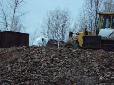
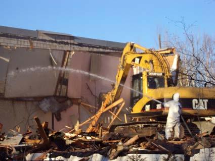
8 Environmental Assessment (EA) in Canada: In Canada, no major project is typically undertaken until the environmental assessment has been approved by regulatory agencies and has undergone a Public consultation process. That said, Canadian regulatory agencies permitted deteriorating buildings and structures to be taken down at the abandoned Gunnar Uranium Mine/Mill Site in to address Public safety issues before completion of EIS document.

. To address safety issues related to site maintenance (e.g., old sumps, tripping hazards, etc.")
9 Putting Public Safety First To take down buildings on the Gunnar Mine site that fail the structural safety assessment. To remove risks on the site related to hazardous substances and materials (including asbestos). To address safety issues related to site maintenance (e.g., old sumps, tripping hazards, etc.)
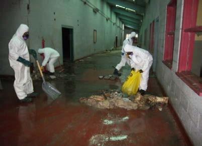
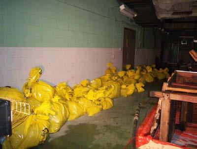
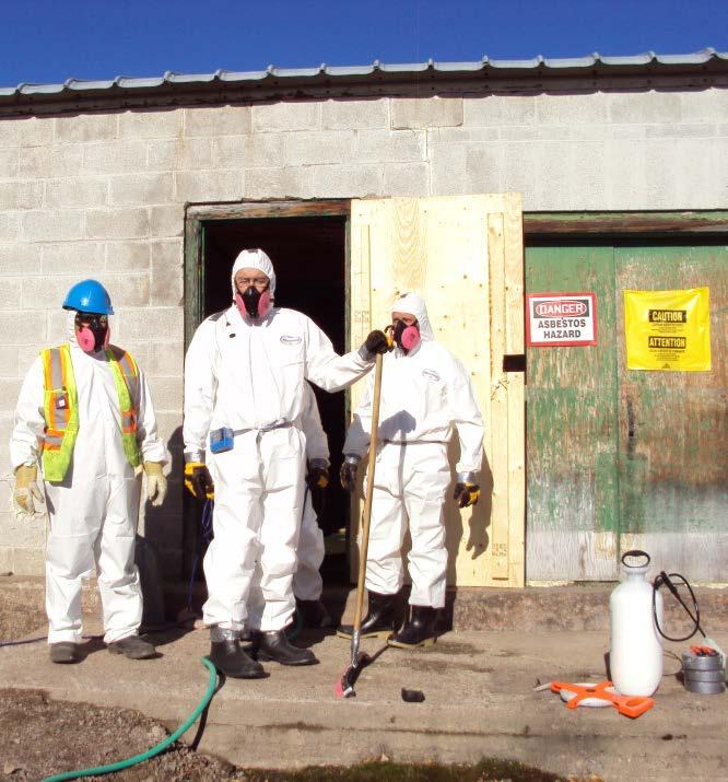


10 Asbestos Abatement:


11 Summary of Demolition
12 Next Step Securing All Aspects of the Gunnar Site Dry Tailings Wet Tailings Buildings and Structures Mine Pit Waste Rock Piles
13 Environmental Assessment (EA) in Canada: In Canada, preferred and alternative remediation options are typically identified as part of the environmental assessment (EA) process and are documented in the Environmental Impact Statement (EIS) before initiation of the Project. However, due to the lack of records and monitoring data, this approach may not be feasible when planning the remediation of abandoned sites that operated under a different regulatory regime, due to the lack of historical information regarding the Site.
14 Postponing option selections to licensing stage In such cases, it may be logical to collect missing information as part of site licensing process, i.e. after the EA has been approved. In this case information gaps required for option analysis can be captured as part of a decision-tree approach, or flow diagrams, that identify key questions that need to be answered once more data and information has been collected to allow informed decisions to be made on remediation options. Unlike a typical EA or EIS, through a decision-tree approach, remedial options can be selected later in the process, as more information becomes available

15 Basic Remediation Alternatives: Mine Pit: Leave as a water body or dewater and use as a waste disposal site? Tailings and Waste Rock: Cover or relocate to mine pit? Relocate contaminated waste rock to an engineered lined landfill and use clean waste rock as cover on tailings? Waste Disposal: Dispose of in the mine pit or an approved landfill?
 Program 3. Perform studies to fill information gaps Yes No 2.")
 Public safety Human health Ecological 7.")
16 Gunnar Project Decision Making Process 1. Assemble and analyze information base - site characterization, contaminated site model, special reports, data reports, etc. 14. Application for site specific release CNSC Province 15. Institutional Control (IC) Program 3. Perform studies to fill information gaps Yes No 2. Is information satisfactory to perform risk and effect assessments? 5. Is residual risk justifiable for site specific release / exemption? No 6. Identify reasonable remediation options that will reduce human health/ environmental risks Yes 4. Assess current risk (if required) Public safety Human health Ecological 7. Assess technical feasibility of potential option(s) and establish expected performance objectives 8. Can an option(s) be selected and feasibly implemented based on benefit/cost assessment No 12. None identified 13. Alternative risk management strategy (e.g. Fish consumption guidelines, posting signs, land use restrictions) Yes 9.Implement option(s) 10. Monitor risk reduction *Note - Each diamond shape represents a decision point that will require stakeholder and community consultation. No 11. Has expected risk reduction been achieved? Yes
.")
17 Application of a Decision-tree Approach in Remediation Planning: First, all possible remediation options should be identified. Each remediation option should then be evaluated and prioritized, and non-viable options should be screened out (e.g., Do Nothing option for unconfined tailings, which need to be covered). A gap analysis should be undertaken for all viable remediation options. Flow diagrams, or decision-trees, should be established to map out plans to fill in key information gaps that are required in decisionmaking (i.e., to identify remediation options).
18 Gunnar Main Tailings Conceptual Decision Tree Cover on Tailings Waste rock to pit Assess Potential Cover Options -Waste Rock -Till - Membrane Assess Potential Cover Options -Till - Membrane Design Cover
19 Remedial Option Analysis - Gunnar Main Tailings Site Aspect Area of Risk Risk Is Risk a Driver for Remedial Action? Remedial Options Decision Point Gunnar Main Tailings Source: Bare tailings and immediate area Intermediate Pathways: Historical flow path between Gunnar Main and Gunnar Central Multiple flow paths to Lake Athabasca: Catchment 3, soccer field, acid plant, open pit, waste rock seep, etc. Receiving Environment: St. Mary's Channel/Zeemel Bay (via Catchment 3 and Waste Rock piles) Langley Bay (via Catchment 2 Surface Flows) Gamma Exposure Human Health Risks (non-gamma) Ecological Risks (non-gamma) Physical Hazards Gamma Exposure Human Health Risks (non-gamma) Ecological Risks (non-gamma) Physical Hazards Gamma Exposure Human Health Risks (non-gamma) Ecological Risks (non-gamma) Physical Hazards Yes No Yes No Yes No Yes No No, not applicable Yes Yes No Rationale: It is generally not acceptable to leave accessible areas of unconfined tailings or accessible areas where levels of gamma radiation exceed allowable dose limits exposed. Rationale: Hunting or fishing not occurring in this area and will not be encouraged in the future. Rationale: Potential ingestion risk Rationale: No physical risks present Rationale: It is generally not acceptable to leave accessible areas of unconfined tailings or accessible areas where levels of gamma radiation exceed allowable dose limits exposed. Rationale: Hunting or fishing not occurring in this area and will not be encouraged in the future. Rationale: Potential ingestion risk Rationale: No physical risks present Rationale: Potential consumption risk (aquatic life/water) Rationale: Potential ingestion risk; potential risk to aquatic organisms via direct contact with water and sediment. Rationale: No physical risks present 'Do Nothing Gamma Shield - Local Borrow Relocation 'Do Nothing' (i.e. gamma shield only) Augment cover design proposed for mitigation of gamma exposures, above 'Do Nothing' (i.e. gamma shield only on Gunnar Main proper, leave tailings beyond boundary unaddressed) Cover (Extension of Gunnar Main Cover to Mitigate Gamma Exposure in Triangular Tailings mass in Catchment 3) Consolidate Tailings on Gunnar Main and Cover 'Do Nothing' (Gamma shield on Gunnar Main proper and mitigation of gamma in triangular tailings mass in Catchment 3); construct permanent, engineered control structure in the area of standing water formed by beaver dams north of Gunnar Main Augment cover design proposed for mitigation of gamma exposures, above; construct permanent, engineered control structure in the area of standing water formed by beaver dams north of Gunnar Main 'Do Nothing' Gamma shield in source area as per above Augment cover design proposed for mitigation of gamma exposures at Gunnar Main, as per above 'Do Nothing' Gamma shield in source area as per above Augment cover design proposed for mitigation of gamma exposures at Gunnar Main, as per above. Decision that 'Do Nothing' is unacceptable is justified by precedence from other mine sites. Aside from confirmation of gamma dose readings, no further information is necessary to justify remediation based on this driver. Cover is the preferred option over relocation for the following reasons: Relocation poses additional risk through release of contaminated porewater. Need to determine where the tailings should go: 1. Relocation to pit would require treatment of entire pit lake. Tailings would completely fill the pit, leaving no room for water treatment residuals. 2. Relocation of tailings would introduce contaminants into downstream receiving waters (i.e. release of porewater). 3. Tailings relocation would be costly - need to account for transportation and cost of backfilling the Gunnar Main footprint 4. Moving tailings to an alternate terrestrial location makes no practical technical sense. 5. Submerging tailings in a natural water body at the site would create a risk to the aquatic pathway where one does not currently exist. Contaminant fluxes to be calculated for the post-gamma shield construction scenario. Modeling to be completed using properties of chosen cover materials to determine the capillary rise (cover needs to be sufficiently thick, or constructed with a capillary break to reduce potential for upward migration of contaminants to near the surface of the cover). In terms of gamma exposure with respect to bare tailings, 'Do Nothing' only acceptable where equipment accessibility is poor. Gamma exposures must be mitigated in triangular area immediately east of Gunnar Main, either by covering as an extension of the Gunnar Main cover, or by consolidating them on Gunnar Main proper. Thinly dispersed inaccessible tailings farther afoot from Gunnar Main may be left 'as-is'. The impoundment of water north of Gunnar Main requires stabilization to maintain the impoundment such that the potential for particulate and contaminant transfer down the watershed is minimized. Follow-up field work and modelling will be completed to determine the preferred location for this structure. Monitoring and/or modeling required to determine whether a gamma barrier at Gunnar Main and immediate vicinity will mitigate ecological and human health risks in the receiving environment. Gamma shield to incorporate capillary break, if necessary, to limit capillary rise of contaminants from underlying tailings to the surface to maintain reductions in risk to ecological and human health. Contaminant flux estimates to be made during detailed engineering for the post-cover construction (gamma shield) scenario to determine if design needs to be augmented somehow to mitigate risks in the intermediate pathway(s) and receiving environment. Exposed tailings in intermediate pathway between Gunnar Main and Gunnar Central are largely inaccessible and will likely remain as-is. Gamma exposures from the triangular area of bare tailings will be addressed either through consolidation with the Gunnar Main tailings or through extension of the Gunnar Main cover. Thinly dispersed tailings in Catchment 3, farthest afoot from Gunnar Main also likely to remain as-is. The impoundment of water formed by historical beaver dams requires a permanent form of stabilization to mitigate/reduce particulate transfer down the watershed and serve as a potential point of secondary control should further water quality improvements be required in the future. Follow-up field work and modeling will be completed to determine the preferred location for this structure. The volume of water that must be drained to allow for construction of this feature will be calculated as part of detailed design.
20 Our Decisions Will be Based on Monitoring Data: Gamma dose rates Radon monitoring Surface water sampling Quantification of water flows Waste rock characterization Groundwater sampling Vegetation sampling Fish sampling Building a quantitative Site-wide model to estimate contaminant flux (or loads)

21 Gamma Dose Rates


22 Gunnar Climate, Radon and Dust fall Monitoring Locations:

23 Ground water monitoring: 86 piezometers

24 Surface Water Monitoring: Selection of Routine Monitoring Locations


25 Characterization of Water Budgets through Flow Monitoring: Resultant monitoring data will be used to parameterize a quantitative Site-wide model, which will serve as the basis for decisions a key decision-tree points during Site licensing.
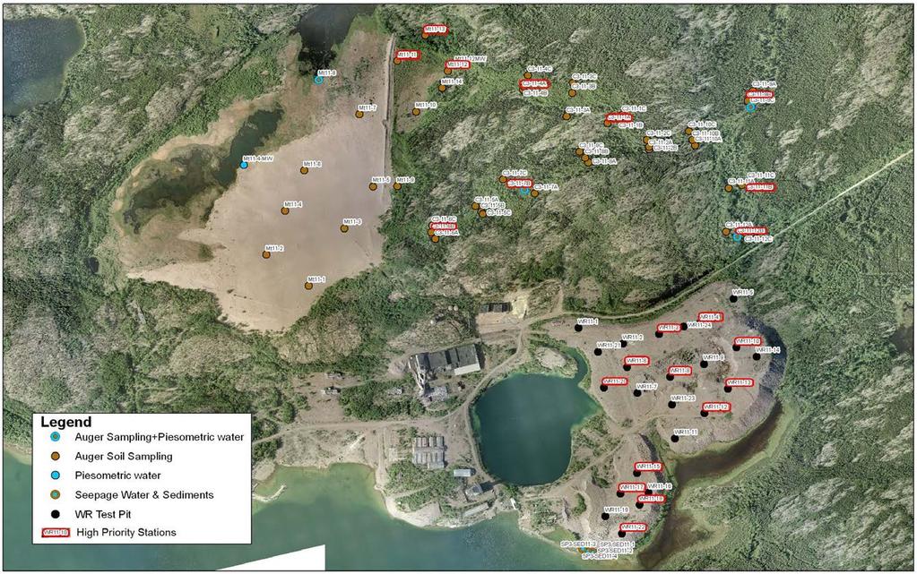
26 Waste Rock Characterization:

27 Borrow Characterization: Where, the amount of borrow material required is dependent upon the remedial option
 Wollaston, April 2011 Uranium City, April 2011 The Main")

28 Getting the Word Out Community meetings are routinely held in: Uranium City Camsell Portage Fond du Lac Wollaston Lake Stony Rapids Black Lake (with periodic visits to Fort Chipewyan) Wollaston, April 2011 Uranium City, April 2011 The Main Questions Discussed: What are the impacts of the Project? What types of remediation options could be used? Are there any training opportunities to build capacity? Are there any job opportunities? How can we actively participate in the remediation?
29 Community Feedback: Cleanup Options flyer Briefs on the options and included a Feedback Form. Request to tick one option and add comments. Suggestions on other solutions for any option were welcomed. Input from Communities through a Feedback Form. Outcomes of Community meetings have led to identification of remediation options.

30 Joint Training Partnerships: SRC, PAGC and QMLP 50% funded by the Government of Canada's Aboriginal Skills and Employment Partnership. Objective: To provide capacity building and employment opportunities in the Athabasca Basin Region. Seven communities: Hatchet Lake First Nation, Wollaston Lake, Black Lake First Nation, Stony Rapids, Fond du Lac First Nation, Uranium City and Camsell Portage.

31 Recycling at Gunnar: A Homegrown Initiative


32 Key Conclusions: The approach used for remediation planning may differ for abandoned sites, such as the Gunnar Site in northern Saskatchewan. Regulator may approve the decision-tree approach to EIS, yet they want to see a clear road map for the way forward, and the criteria for option selection must be well defined To the extent possible, it is important involve local communities in clean-up efforts so they can play an active role, while gaining skill sets and economic benefits from the remediation.

33 Thank You! Any Questions? For more info