ENVIRONMENTAL ASSESSMENT WORKSHEET
|
|
|
- Dinah Jones
- 5 years ago
- Views:
Transcription
1
2 ENVIRONMENTAL ASSESSMENT WORKSHEET Note to reviewers: The (EAW) provides information about a project that may have the potential for significant environmental effects. This EAW was prepared by the Minnesota Pollution Control Agency (MPCA), acting as the Responsible Governmental Unit (RGU), to determine whether an Environmental Impact Statement (EIS) should be prepared. The project proposer supplied reasonably accessible data for, but did not complete the final worksheet. Comments on the EAW must be submitted to the MPCA during the 30-day comment period which begins with notice of the availability of the EAW in the Minnesota Environmental Quality Board (EQB) EQB Monitor. Comments on the EAW should address the accuracy and completeness of information, potential impacts that are reasonably expected to occur that warrant further investigation, and the need for an EIS. A copy of the EAW may be obtained from the MPCA by calling An electronic version of the completed EAW is available at the MPCA website 1. Project Title: 2. Proposer: Kandiyohi County 3. RGU: Minnesota Pollution Control Agency Contact Person Jeff Bredberg Contact Person Debra Moynihan and Title Environmental Services Director and Title Project Manager Address 400 Southwest Benson Avenue Address 520 Lafayette Road North Willmar, Minnesota St. Paul, Minnesota Phone extension 5258 Phone Fax Fax jeff_b@co.kandiyohi.mn.us debra.moynihan@state.mn.us 4. Reason for EAW Preparation: EIS Scoping Mandatory EAW X Citizen Petition RGU Discretion Proposer Volunteered If EAW or EIS is mandatory give EQB rule category subpart number and name: Minn. R , subp. 17B Solid Waste For expansion by 25 percent or more of previous capacity of a mixed municipal solid waste disposal facility for up to 100,000 cubic yards of waste fill per year. 5. Project Location: County Kandiyohi City/Twp New London 1/4 NE 1/4 Section 24 Township T121N Range R35W GPS Coordinates: N W Tax Parcel Number p-ear2-07a TDD (for hearing and speech impaired only): Printed on recycled paper containing 30% fibers from paper recycled by consumers
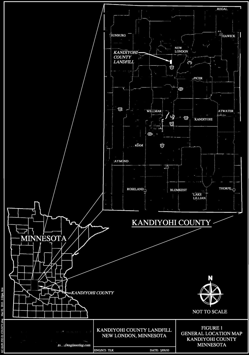
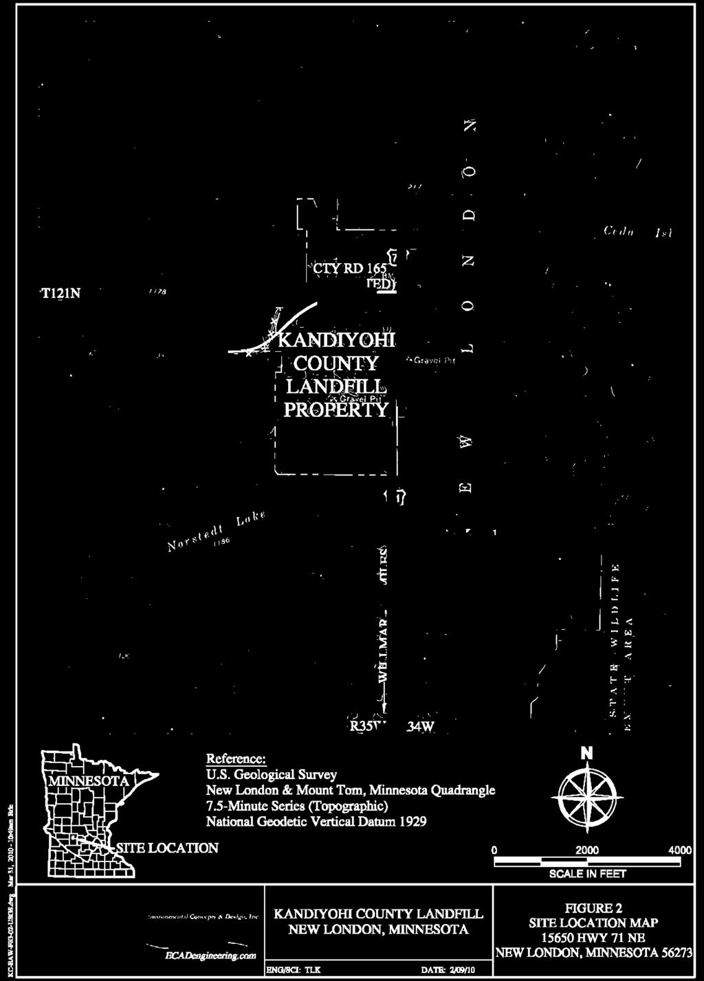
3 Figures attached to the EAW Figure 1 General Location Map, Kandiyohi County, Minnesota Figure 2 Site Location Map, Highway 71 NE, New London, Minnesota, Figure 3 Existing Conditions and Proposed Development Area, March 2010 Figure 4 Existing Leachate Management System Figure 5 Proposed Leachate Management System & Liner Layout Figure 6 Closure Design and Stormwater Management for Figure 7 Ecological and Soil Resources Figure 8 Watershed and Surface Water Receptors Attachments to the EAW Attachment 1 Minnesota Department of Natural Resources (DNR) Division of Ecological Resources Natural Heritage Information System (NHIS) Database Request Attachment 2 DNR Recreation Compass Map Attachment 3 Kandiyohi County Planning & Zoning, Lake Andrew Township 6. Description: a. Provide a project summary of 50 words or less to be published in the EQB Monitor. Kandiyohi County (or County), Minnesota is proposing a horizontal/vertical expansion of the existing waste cells within the Kandiyohi County Landfill. The proposed project would be would provide capacity for approximately 20 additional years of operation. b. Give a complete description of the proposed project and related new construction. Attach additional sheets as necessary. Emphasize construction, operation methods and features that will cause physical manipulation of the environment or will produce wastes. Include modifications to existing equipment or industrial processes and significant demolition, removal or remodeling of existing structures. Indicate the timing and duration of construction activities. Background The Kandiyohi County Sanitary Landfill is a mixed municipal solid waste (MSW) landfill owned and operated by Kandiyohi County. The landfill is located within 320 acres of County-owned land in the southwest quadrant of the intersection of Trunk Highway 71 (TH 71) and 165 th Avenue NE, approximately 11 miles north of Willmar (Figure 1). The landfill occupies approximately 100 acres of the east half of the northeast quarter of Section 24, Township 121 North, Range 35 West (Figure 2). The facility has been operating since 1969 and began accepting waste under MPCA Solid Waste Permit No. SW-79 in July The landfill is currently operating under the Modified Solid Waste Permit No. SW-79 dated July 17, Significant portions of the 320-acre property have been disturbed for use as soil borrow areas for daily cover and clay borrow areas over the course of the landfill s operating history. Operating History The original waste disposal design capacity was 5,345,000 cubic yards (CY). The current in-placed waste volume is approximately 2,416,083 CY in Phases 1-6. The closed Phase 1 MSW fill area is the 23-acre unlined portion of the facility. The final cover system (cap) is in place over the Phase 1 area. New London Township, Minnesota 2
4 The cap is made up of a synthetic membrane layer, a sand drainage layer, a passive gas venting system, and design features that restrict surface water infiltration into the closed fill area, thereby reducing leachate generation. The existing lined MSW fill area consists of Phases 2-6 and occupies approximately 10.6 acres within the facility. Phases 2, 3, and 4 are closed with final caps installed. Phase 5 is closed with half the cap installed. Phase 6 is currently open and accepting waste. The lined fill area construction includes a composite clay/synthetic liner, a leachate collection system, and a leak detection system. Surface water conveyance channels and several sedimentation ponds have been incorporated into the site design to control run-on and run-off to reduce the amount of sediment transported off site. The landfill has a groundwater monitoring network consisting of 20 routine monitoring wells on-site (Figure 3), and one off-site residential well. Current Landfill Activity Waste material for landfilling is brought to the landfill gate and weighed at a scale. From there, it is brought to the current working face where waste is deposited. The waste material is then compacted by the operator using a compactor. After compaction, a daily cover material, usually mineral soil or other approved alternative daily cover materials are placed on top of the waste to prevent nuisance conditions such as extreme odor, windblown debris, or animals digging at landfilled material. The operators also perform monitoring and maintenance activities on the leachate collection system to assure continued operations under MPCA guidelines. The County also operates a 24-acre permitted construction and demolition (C&D) disposal area site within the current landfill boundaries, which also includes a groundwater monitoring compliance boundary. Additional site uses include an appliance and hazardous waste drop-off transfer station at the site entrance, and County highway storage locations for highway construction equipment and supplies, along with road salt stock piling. The property west of the permitted C&D solid waste disposal area is used for a grass, leaves, and brush compost site, and as a burn site for noncompostable tree waste or brush. Proposed Project The proposed expansion involves construction of two lined cells (). Development of these cells would include a synthetic liner, leachate collection, landfill gas collection, access roads, and stormwater control structures. The design capacity of is 1,213,517 CY on a 13.7-acre footprint (Figure 3). The construction of the western portion of will cover approximately 7.3 acres over the existing unlined Phase 1 closed portion of the landfill. The new waste cell liner will be constructed up the side of the closed landfill over the in-place waste and connect with the flexible liner cap that is currently in place. The eastern portions of will be constructed over ground that contains no previously disposed waste and will cover approximately 6.5 acres. New London Township, Minnesota 3
5 Liner Construction Liner construction over new ground requires clearing, grubbing, and stripping topsoil from the area to be developed. The bottom of the landfill will then be graded to establish a firm subgrade for construction of the liner and leachate collection system. The liner will be constructed of specified liner materials including a 60-mil thick layer of high-density polyethylene (HDPE) that is placed on top of two feet of select clay. The clay is expected to come from a local source and will be trucked to the site and placed according to conservative regulatory requirements. The HDPE membrane is placed on top of the clay with fusion or extrusion welded seams that are tested for leaks before the leachate collection system is placed on top of the liner. All of the liner and leachate collection systems will be tested and certified by the contractor, owner, and inspected by the MPCA permit engineer before approval for waste by the MPCA. Final Cover Construction Final cover construction will be completed once are full. Final cover construction requires excavation of intermediate soil material from the Kandiyohi County property adjacent to the landfill development. This property is located north of 165 th Avenue NE and west of the Phase 1 unlined disposal area. Topsoil that is present will be stripped and stockpiled from these borrow areas to get to the underlying mineral soil. Mineral soil from those areas will be excavated and hauled to the final cover area for placement and compaction. A flexible membrane liner (FML) cap will be placed on top of the intermediate material to seal the landfill. Additional cover material placed will include a sand drainage layer to protect the FML cap and increase surface water drainage, and a rooting and topsoil layer to establish shallow rooting vegetation to prevent soil erosion. Storm Water Controls Stormwater controls are described in Item 17 of this EAW. Leachate Collection Leachate is created from water percolating through or coming in contact with the MSW. The leachate collection system consists of gravity drain piping that collects and transfers leachate to storage tanks from Phases 2, 3, 4, and 5. Phase 6 and future phases have leachate collection pumps that transfer the leachate from the bottom of the liner to transfer piping that carries it to the storage area. The existing storage area has two 15,000-gallon underground storage tanks, and two additional 25,000-gallon underground storage tanks will be added as a part of this and future proposed expansions. A pump and loading rack enclosure is used to transfer the leachate from the storage tanks to the tanker trucks that haul the leachate to the wastewater treatment facility for treatment. The leachate from the underground storage tank is pumped to a semi-tanker truck, which transports the leachate to Metropolitan Council Environmental Services (MCES) wastewater treatment facility in St. Paul for treatment. The 2008 contingency action plan (November 2008) outlines procedures that will be followed for environmental contingencies in the event of a spill. Landfill Gas The landfill has an existing passive landfill gas venting system that was installed on closed portions of the landfill. This passive gas venting system has been installed to prevent the buildup of gases generated through anaerobic degradation of waste. Landfill gas is composed mostly of carbon dioxide New London Township, Minnesota 4
6 and methane with small amounts of hydrogen sulfide and ammonia. will be connected into the existing passive gas system at the landfill. Please see Item 23 below for additional information. Groundwater Contamination and Remediation Groundwater contamination and remediation are described in Item 19 of this EAW. Construction timing In general, Phase 7 is not expected to be needed until Depending on loads and quantities of waste and other factors, may be constructed as a series of four cells. Scheduled development of each cell would follow based on the 2008 permit filling projections. If four cells are built, development on Phase7A would begin in 2012, Phase 7B in 2015, Phase 8A in 2019, and Phase 8B in c. Explain the project purpose; if the project will be carried out by a governmental unit, explain the need for the project and identify its beneficiaries. The project is required to meet MSW disposal needs of Kandiyohi County communities. d. Are future stages of this development including development on any other property planned or likely to happen? Yes No If yes, briefly describe future stages, relationship to present project, timeline and plans for environmental review. Kandiyohi County plans to continue to expand the waste area to the north with Phases 9 and 10 after are filled. This EAW addresses the Phase 7 and 8 expansions. Phase 7 consists of a design capacity of 617,997 CY and Phase 8 consists of a design capacity of 595,520 CY for a combined total design capacity of 1,213,517 CY for. The combined total design capacity of Phases 1 through 8 (3,763,742 CY) will become the baseline threshold for future environmental review. Using the current threshold stated in Minn. R , subp. 17,B; an expansion exceeding the previous capacity plus 25 percent of that capacity (4,704,678 CY) would trigger environmental review. Environmental review may be required prior to permitting and construction of Phases 9 and 10. e. Is this project a subsequent stage of an earlier project? Yes No If yes, briefly describe the past development, timeline and any past environmental review. No previous environmental review has been conducted on the existing landfill. The site has been developed as a waste disposal facility since The MPCA issued permit SW-079 for the site on July 10, The Phase 1 unlined disposal area was constructed as a trench and fill operation and occupies roughly 23 acres on the site. Development of Phases 2-4 was included in the 1993 permit re-issuance to occupy 10.6 acres within the facility. Phases 5 and 6 were planned developments included in the 1992 permit application. New London Township, Minnesota 5
7 The permit application for 2008 includes designs and specifications to complete the 1972, 80-acre design footprint. The 2008 permit application proposes the addition of Phases 7 through 10; however, this EAW only addresses. Table 1 Phase Status area (acres) Capacity w/cover (cubic yards) Filled to date (cubic yards) EXISTING Phase I MSW and Demolition Waste Closed unlined and final cap ,491,000 1,491,000 Phase II MSW Disposal Area Closed lined and final cap , ,000 Phase III MSW Disposal Area Closed lined and cap , ,225 Phase IV MSW Disposal Area Open lined and uncovered , ,000 Phase V MSW Disposal Area Open lined and uncovered , ,247 Phase VI MSW Disposal Area Open lined and uncovered , ,611 PROPOSED EXPANSION Phase 7A MSW Disposal Area Proposed , Phase 7B MSW Disposal Area Proposed , Phase 8A MSW Disposal Area Proposed , Phase 8B MSW Disposal Area Proposed , Phase 9A MSW Disposal Area Proposed , Phase 9B MSW Disposal Area Proposed , POSSIBLE FUTURE EXPANSION Phase 10A MSW Disposal Area Future , Phase 10B MSW Disposal Area Future , DEMOLITION Phase 1 demolition Disposal Area Closed-unlined and final cap ,670 86,670 Phase II Demolition Disposal Area Open-unlined and uncovered ,840 41,938 Phase III Demolition Disposal Area Proposed , Project Magnitude Data Total Project Area (acres) 14 or Length (miles) Number of Residential Units: Unattached 0 Attached 0 Commercial/Industrial/Institutional Building Area (gross floor space): Maximum Units Per Building: total square feet Indicate area of specific uses (in square feet): Office Manufacturing Retail Other Industrial Warehouse Institutional Light Industrial Agricultural Other Commercial (specify) Building height If over 2 stories, compare to heights of nearby buildings New London Township, Minnesota 6
8 8. Permits and approvals required. List all known local, state and federal permits, approvals and financial assistance for the project. Include modifications of any existing permits, governmental review of plans, and all direct and indirect forms of public financial assistance including bond guarantees, Tax Increment Financing and infrastructure. All of these final decisions are prohibited until all appropriate environmental review has been completed. See Minn. R Unit of Government Type of Application Status MPCA Application for Construction and Operation of a Solid Waste Land Disposal Facility Permit Application submitted, draft permit on public notice MPCA National Pollutant Discharge Elimination System/State Disposal System (NPDES/SDS) General Stormwater Permit for construction Modify and update existing facility permit number MN R as needed activities MPCA NPDES/SDS Industrial Stormwater Permit Modify and update existing facility permit number G as needed MPCA Certificate of Need Approved MCES Special Industrial Discharge Permit Already issued for the existing Minnesota Department of Health Monitoring Well Permits facility permit number #2157 Ongoing 9. Land use. Describe current and recent past land use and development on the site and on adjacent lands. Discuss project compatibility with adjacent and nearby land uses. Indicate whether any potential conflicts involve environmental matters. Identify any potential environmental hazards due to past site uses, such as soil contamination or abandoned storage tanks, or proximity to nearby hazardous liquid or gas pipelines. The landfill site is made up of active and closed landfill waste cells, sparsely wooded prairie acreage of grasslands, and former farm lands and trails to existing groundwater monitoring wells. The developed solid waste disposal area is described in Item 6 above. The undeveloped solid waste disposal area for is being used as an active, soil borrow area. The other development on the site includes an equipment storage shed and refueling station for the County highway department. The impervious surface areas are primarily roads, including 165 th Avenue NE and TH 71, along with the entrance to the facility, and a cemented area around the on-site equipment shed. The disturbed prairie areas are those areas outside of the permitted waste disposal areas that have been used for on-site topsoil stockpiles, soil borrow areas, or areas where 165 th Avenue NE was rerouted for traffic. The Dry Sand and Gravel Prairie acreage was determined by the Minnesota County Biological Survey (MCBS); see Item 10 below. The wetlands are identified by the National Wetlands Inventory, provided by the DNR. The water appears to be a pond that is not connected to the water table. Parts of the disturbed prairie to the west are used for the compost and burn site, which occupies less than an acre as identified on Figure 7. New London Township, Minnesota 7
9 Groundwater monitoring is ongoing at the site (Figure 3) as part of the overall corrective action monitoring and investigation of contamination from the closed Phase 1 unlined disposal area. See Item 19 for detailed information. Material landfilled in the Phase 1 unlined disposal area is acting as a source of groundwater contamination migrating from the landfill. 10. Cover Types. Estimate the acreage of the site with each of the following cover types before and after development: Land Use Before After Description Acres Sparsely Wooded Prairie Developed Solid Waste Disposal Area (vertical) Undeveloped Solid Waste Disposal Area (horizontal) County Equipment Storage and Refueling Station 3 3 Impervious Surface 7 7 Disturbed Sparsely Wooded Prairie Dry Sand and Gravel Prairie Wetland 2 2 Water 2 2 TOTAL Fish, Wildlife, and Ecologically Sensitive Resources. a. Identify fish and wildlife resources and habitats on or near the site and describe how they would be affected by the project. Describe any measures to be taken to minimize or avoid impacts. No sensitive fish or wildlife resources were identified in the DNR s NHIS request (Attachment 1). b. Are any state (endangered or threatened) species, rare plant communities or other sensitive ecological resources on or near the site? Yes No If yes, describe the resource and how it would be affected by the project. The NHIS identified two areas within the existing landfill property of interest. These include an area identified as Moderate Biodiversity and with that area a Dry Sand & Gravel Prairie containing Native Plant Communities (Figure 7) was identified. Portions of the Dry Sand & Gravel Prairie have already been disturbed during past site development. Upon identification of the Native Plant Communities and the concerns the NHIS expressed in their correspondence, Kandiyohi County will cease any further development or borrow activities within the Dry Sand & Gravel Prairie. An alternative borrow area is available to the north of 165 th Avenue NE, which will be used in the future to avoid disturbing what is left of the Dry Sand and Gravel Prairie identified on Figure 7. New London Township, Minnesota 8
10 The NHIS concern is that 99 percent of the native remnant prairies have been destroyed by agriculture and development in the state of Minnesota. Due to the loss of this once widespread habitat, many prairie-obligate (necessary habitat) species have become rare; more than one-third of Minnesota s endangered, threatened, and special concern species are dependent on the remaining small fragments of Minnesota s prairie ecosystem. Figure 8 illustrates a small part of one wetland on the site as listed according to the National Wetlands Inventory. Development is not expected to impact this area. No physical alterations will need to be made, and no runoff from the project site is expected to flow to any of the identified wetlands. Describe any measures that will be taken to minimize or avoid adverse impacts. Provide the license agreement number (LA- ) and/or Division of Ecological Resources contact number (ERDB ) from which the data were obtained and attach the response letter from the DNR Division of Ecological Resources. Indicate if any additional survey work has been conducted within the site and describe the results. A 25-foot protective buffer around the Dry Sand & Gravel Prairie on landfill property will be staked with signs posted. The buffer will be outlined according to information provided by the NHIS and the MCBS so that site activities would not further impact this area. The buffer will not include portions of the site that include the permitted groundwater compliance boundary. Signs will identify the Dry Sand & Gravel Prairie remnant, indicating the existence of the native plant communities, and that state-protected species may occur within its boundaries. To reduce impact in the area of Moderate Biodiversity, Kandiyohi County will use locations north of 165 th Avenue NE, on its property, for soil excavation needs. In the event that other options for soil excavation become infeasible, Kandiyohi County will only remove soils north and east of the protective buffer. Hydrogeologic and groundwater investigations will occur within the Moderate Biodiversity area. These investigations primarily include boreholes and monitoring wells. Development of monitoring wells and boreholes do not modify the natural topography nor do they strip topsoil to a significant degree; as such, they are not expected to have significant impacts on the site of Moderate Biodiversity. However, heavy equipment and access trails are needed to reach on-site locations, which may have temporary impacts. No additional survey work has been completed nor proposed at this time. 12. Physical Impacts on Water Resources. Will the project involve the physical or hydrologic alteration (dredging, filling, stream diversion, outfall structure, diking, and impoundment) of any surface waters such as a lake, pond, wetland, stream or drainage ditch? Yes No 13. Water Use. Will the project involve installation or abandonment of any water wells, connection to or changes in any public water supply or appropriation of any ground or surface water (including dewatering)? Yes No New London Township, Minnesota 9
11 If yes, as applicable, give location and purpose of any new wells; public supply affected, changes to be made, and water quantities to be used; the source, duration, quantity and purpose of any appropriations; and unique well numbers and DNR appropriation permit numbers, if known. Identify any existing and new wells on the site map. If there are no wells known on site, explain methodology used to determine. No public water supply wells will be installed on site. The landfill office has one well on site for potable water use. Monitoring wells are installed on site for routine or corrective action monitoring of groundwater. The monitoring wells may be purged up to three times a year, and volumes purged result in a couple hundred gallons total per monitoring event. It is not expected that additional monitoring wells will be installed specifically for the proposed project to construct. Future well installations and borings may be required and must be constructed in such a manner as to comply with all applicable state and federal regulations at the time of installation. Monitoring wells are maintained and inspected yearly. 14. Water-related land use management districts. Does any part of the project involve a shoreland zoning district, a delineated 100-year flood plain, or a state or federally designated wild or scenic river land use district? Yes No 15. Water Surface Use. Will the project change the number or type of watercraft on any water body? Yes No 16. Erosion and Sedimentation. Give the acreage to be graded or excavated and the cubic yards of soil to be moved: 29 acres; 450,000 cubic yards. Describe any steep slopes or highly erodible soils and identify them on the site map. Describe any erosion and sedimentation control measures to be used during and after project construction. Erosion and sedimentation control structures will be used during construction to control runoff and minimize the amount of erosion that may occur. Permanent stormwater detention basins and other best management practices will be employed to minimize erosion and eliminate runoff from the site during the active phases of landfilling and after closure of the facility. Once construction is completed, disturbed areas would be restored. Disturbed soil-borrow areas will be restored to prior or better conditions. Slopes would be a maximum of 25 percent and minimum 2 percent. Undisturbed portions are blended into the disturbed portions and then reseeded with flora adaptable to future site conditions. Final cover slopes will be, at maximum, 5 vertical to 1 horizontal. Permitted, undeveloped, and developed areas and control structures that are disturbed by construction will be restored to previous conditions as necessary. All construction projects are required to apply for an NPDES/SDS Construction Stormwater Permit prior to construction. New London Township, Minnesota 10
12 The proposed project is designed to tie the proposed erosion control features into the existing control features as illustrated in Figure 6. This includes additions to dikes, ditches, and drainage features that are a part of the site-specific Stormwater Management Plan. The interior of the undeveloped portions of future Phases 9 and 10 will be drained to an on-site stormwater detention pond. The County keeps its Stormwater Management Plan as part of the NPDES/SDS Permit G Water Quality Surface-water Runoff. a. Compare the quantity and quality of site runoff before and after the project. Describe permanent controls to manage or treat runoff. Describe any storm-water pollution prevention plans. The relative quantity of runoff before and after the project is not expected to change. Runoff within open landfill areas is collected and treated as leachate and does not contribute to the quantity of runoff produced. Areas that are closed with final cover shed runoff away from open areas which add to pre-closure runoff quantities. As open areas are closed and as new areas are opened of comparable size, development over time will generally lead to little or no measurable change in runoff quantity before and after the project. The quality of site runoff before and after the project is not expected to significantly change. Parking areas, driveways and scale house locations will remain the same. Traffic, and facility operations, before and after the project, should remain relatively the same as well. Consequently, no measurable changes are expected in runoff quality. Kandiyohi County Landfill operates under the MPCA approved NPDES/SDS Industrial Stormwater General Permit # MNR0536VT. The facility will continue to operate according to the requirements of that permit before and after the project. A Stormwater Pollution Prevention Plan, which is an enforceable part of the NPDES/SDS Industrial Stormwater Discharge Permit, has been prepared by the County. The NPDES/SDS Industrial Stormwater Discharge Permit will be updated and approved by the MPCA, as needed, to reflect current operations and maintain coverage under the existing permit. The Stormwater Pollution Prevention Plan identifies potential pollutant sources at the landfill, outlines operating procedures for material handling activities and inspections, and describes controls and best management practices that will be used at the facility to minimize pollutants in runoff. Inspections of the landfill site will be conducted monthly and after significant rainfall events to identify any problem areas that may need corrective action. In addition to the stormwater management provisions described above, management practices will also include storage of chemicals indoors or within appropriate containment areas, good site housekeeping practices, and proper disposal of any wastes that cannot be disposed of in the landfill. b. Identify routes and receiving water bodies for runoff from the site; include major downstream water bodies as well as the immediate receiving waters. Estimate impact runoff on the quality of receiving waters. Currently, an existing 24-inch reinforced concrete pipe (RCP) carries runoff off site from an on-site sedimentation basin located within the proposed Phase 7 Area. The runoff is routed through the 24- inch RCP, under TH 71 and into a series of wetlands to the east. With development of Phase 7, the pipe will be abandoned, and all runoff will remain on site. As such, project development should tend to improve water quality of those receiving waters. New London Township, Minnesota 11
13 All other routes direct runoff to on-site sedimentation/infiltration basins though an engineered system of ditches and dikes with surface water drain pipes and erosion prevention materials to manage storm water runoff. There should be no surface water runoff leaving the site; therefore, there should be no impacts to surface waters in the area. 18. Water Quality Wastewater. a. Describe sources, composition and quantities of all sanitary, municipal and industrial wastewater produced or treated at the site. Wastewater collected at the site is primarily leachate. Leachate is generated by rainfall through the open disposal area. All rain falling on open disposal areas is collected after infiltration through the disposal area and then drained through leachate collection pipes. The collection pipes drain into storage tanks on site. The existing open disposal area generates roughly 6,000 gallons of leachate per day. The construction of may initially increase quantities, but the leachate production rates are dependent upon rainfall and infiltration rates. As new cells are open, finished cells are closed, which reduces the amount of precipitation that is turned into leachate. The total disposal area open to precipitation tends to remain the same. The water quality of leachate tends to be high in total suspended solids and chloride and has a high relative chemical oxygen demand. Concentrations for 2011 were the following: Chloride 2,250-2,500 mg/l Total suspended solids 18-1,400 mg/l Chemical oxygen demand 945-2,020 mg/l Other constituents tend to be minor, including metals and volatile organic compounds. The leachate generated at this facility meets the MCES permit standards. The addition of are not expected to change the quality of leachate generated, therefore, will not affect the leachate treatment and storage areas. The design of the landfill includes a stormwater system to prevent surface water run-on during active landfill operations and a low-permeability final cover to reduce precipitation infiltration after closure. Together, these systems are intended to substantially reduce the amount of leachate that is produced after landfill closure. b. Describe waste treatment methods or pollution prevention efforts and give estimates of composition after treatment. Identify receiving waters, including major downstream water bodies (identifying any impaired waters), and estimate the discharge impact on the quality of receiving waters. If the project involves on-site sewage systems, discuss the suitability of site conditions for such systems. Leachate is temporarily stored at the landfill and transported off site for treatment and disposal. New London Township, Minnesota 12
14 c. If wastes will be discharged into a publicly owned treatment facility, identify the facility, describe any pretreatment provisions and discuss the facility s ability to handle the volume and composition of wastes, identifying any improvements necessary. Leachate produced during operations and after closure of the waste cells is collected and transported to the MCES St. Paul wastewater treatment facility for treatment. Willmar Wastewater Treatment Plant (WWTP) is an additional option for leachate disposal and treatment. However, the quality and quantity of leachate produced at this site is currently greater than its handling capacity. Improvement to the Willmar WWTP capacity could reduce the necessity of using the MCES facility in St. Paul. 19. Geologic hazards and soil conditions. a. Approximate depth (in feet) to Ground water: 1 minimum; 60 average. Bedrock: 400 minimum; 430 average. Describe any of the following geologic site hazards to ground water and also identify them on the site map: sinkholes, shallow limestone formations or karst conditions. Describe measures to avoid or minimize environmental problems due to any of these hazards. No geographic hazards exist at the site. b. Describe the soils on the site, giving Natural Resources Conservation Service classifications, if known. Discuss soil texture and potential for ground-water contamination from wastes or chemicals spread or spilled onto the soils. Discuss any mitigation measures to prevent such contamination. The primary soil types on site are gravelly sand or sand. Secondary soils are sandy clay loams and clay. The cation exchange capacity for the gravelly loam is 1-5 meq/100g. For the sandy clay loam, it ranges from 5-25 meq/100g. Data was obtained through the Natural Resources Conservation Service database, dated May 15, The ability to retain cations reduces the hazards of groundwater pollution. Unsaturated soils beneath the project area consist of the primary soil type of gravelly sand, deposited as outwash from glaciations. Many small (< 1 foot) to large (> 5 feet) layers of clay can be found within the outwash sediment. The gravelly and coarse layers of sand allow relatively permeable flow conditions to occur. Clay lenses, sandy clay, and silty lenses provide impediments and adsorption capabilities that restrict vertical contamination pathways. Although coarse sand and gravel readily allow infiltration of contaminates into the groundwater, silty to clayey lenses provide adsorption/retention properties that can significantly decrease contaminate concentration gradients. Contamination occurring through rainwater interaction with landfilled material is the primary concern. Construction and engineering materials prevent the primary source of contamination from beneath the landfill. Secondary concerns are ponding and runoff from waste disposal. To prevent the occurrence of ponding and runoff from disposal areas, engineered controls are New London Township, Minnesota 13
15 designed to keep runoff within open cells and collected as leachate for off-site treatment. Disposal cells are also brought up to design grades and elevations as quickly as possible. Final cover is placed to prevent further infiltration of rainwater. Historical Contamination Contaminated materials contained within the Phase 1 unlined disposal area and the soils beneath it are acting as a source of groundwater contamination that is migrating from the landfill. It is expected that this material will continue to act as a source of groundwater contamination. The magnitude of soil contamination is not currently well understood. A study was done in 2010 to determine the magnitude of contamination within the Phase 1 unlined disposal area. The results from the 2010 summer season are expected in 2011 with additional investigation occurring during the summer of Corrective action measures will continue to be developed in 2011 and are expected to be implemented in 2012 with the objective to define and mitigate further impacts to groundwater quality and human and other potential receptors down-gradient from the landfill. Groundwater generally flows in a west and northwest (predominantly northwest) direction from the landfill. The data generated from the groundwater investigations so far suggest that groundwater flowing from beneath the proposed new waste cell locations may be intercepted by the existing monitoring network. However, continued corrective action investigations of groundwater contamination prior to and during development of are scheduled to occur to evaluate the need for additional monitoring down-gradient of the proposed Phases 7 and 8. Parts of will be developed on top portions of the Phase 1 unlined disposal area. The existing groundwater monitoring network for the landfill consists of 20 routine monitoring wells on site (Figure 3), and one off-site residential well. The routine monitoring wells are placed around the site to monitor groundwater. Groundwater flows predominantly in a northwest direction from the site. Development of the proposed additional phases and cells would not warrant expansion of the routine monitoring network. Hydrogeologic investigations have been performed on site since The data generated from these investigations suggest that groundwater flowing from beneath the proposed locations may be intercepted by the existing monitoring network. Groundwater monitoring is being done continuously at 12 on-site corrective action monitoring wells and 2 off-site private wells as part of the overall corrective action monitoring and investigation of contamination from the closed Phase 1 unlined disposal area. Continued corrective action investigations of groundwater contamination prior to and during development of are scheduled to occur to evaluate the need for additional monitoring downgradient of the proposed. New London Township, Minnesota 14
16 20. Solid Wastes, Hazardous Wastes, Storage Tanks. a. Describe types, amounts and compositions of solid or hazardous wastes, including solid animal manure, sludge and ash, produced during construction and operation. Identify method and location of disposal. For projects generating municipal solid waste, indicate if there is a source separation plan; describe how the project will be modified for recycling. If hazardous waste is generated, indicate if there is a hazardous waste minimization plan and routine hazardous waste reduction assessments. This facility accepts mixed municipal solid waste in the amount of approximately 35,000 tons per year for final disposal. On-site waste production is in the form of used oil, filters, antifreeze, office waste, and materials used in association with landfill operations. The waste that is generated is recycled, landfilled appropriately, or handled according to the landfill s industrial waste management plan. Hazardous wastes are not accepted for disposal at this landfill. The County has a solid waste management program in place, which includes public education, composting, temporary household hazardous waste storage and transfer, and on-site recycling. b. Identify any toxic or hazardous materials to be used or present at the site and identify measures to be used to prevent them from contaminating ground water. If the use of toxic or hazardous materials will lead to a regulated waste, discharge or emission, discuss any alternatives considered to minimize or eliminate the waste, discharge or emission. Household toxic and hazardous waste brought on site is collected in a secured shed and disposed of by certified disposal experts. Televisions, tires, and cardboard are collected on site and shipped to proper recycling and disposal locations. Leachate generated at the site is contained in storage tanks and hauled to a wastewater treatment plant (see Item 18). The loading area for leachate into the haul truck is constructed to prevent spillage and protect groundwater. c. Indicate the number, location, size and use of any above or below ground tanks to store petroleum products or other materials, except water. Describe any emergency response containment plans. Currently the landfill has two 15,000-gallon fiberglass storage tanks on site, as illustrated in Figure 4. The tanks are double walled. Leaks in the primary wall would be contained by the secondary wall. Brine levels are measured to verify containment. The underground tank is pumped to a truck semi-tanker, which transports the leachate to a wastewater treatment facility. The leachate collection system has double walled transfer piping to prevent leaks from entering the ground and groundwater. If a leak develops in the transfer piping, the outer secondary containment piping directs the leachate to manholes that have been treated with epoxy coatings that will contain the leachate until it is pumped out for storage or treatment, and the leaking pipe is repaired. New London Township, Minnesota 15
17 A spill containment slab will direct any spills from loading tanker trucks into a control catch basin and direct it back into the leachate storage tanks. The storage tanks are doubled walled to contain leaks that may develop in the inner wall of the tank. The storage tanks will also be equipped with automated tank full alarm lights which will notify operators inside the scale house and pump control room if storage capacity is reached in any of the four storage tanks. An additional storage alarm light installed on the outside of the pump control housing, visible from the scales house and disposal area entrance, will turn on when all the storage tanks are full. If the light goes on, collection pumps will be automatically turned off. This will help prevent spills from over filling storage tanks, and notify site personnel that transfer station operations should be accelerated immediately to avoid spills from over filling the storage facility. The landfill has a Contingency Action Plan and Leachate Management Plan that provides response procedures should a leak or spill occur. 21. Traffic. Parking spaces added: 0 Existing spaces (if project involves expansion): 5 Estimated total average daily traffic generated: 90 Estimated maximum peak hour traffic generated and time of occurrence: 61 around noon time Indicate source of trip generation rates used in the estimates. Using the format and procedures described in the Minnesota Department of Transportation s Traffic Impact Study Guidance (available at or a similar local guidance, provide an estimate of the impact on traffic congestion on affected roads and describe any traffic improvements necessary. The analysis must discuss the project s impact on the regional transportation system. The landfill currently receives approximately 60,000 cubic yards of waste per year. MSW is delivered to the landfill Monday through Saturday. The trucks access the landfill via U.S. Highway 71. The current estimated average daily traffic volume for the landfill is as follows: 2-3 semi-trailer trucks 9-10 packer trucks from private haulers 8-9 roll off trucks 6-7 employee and service vehicles 2-3 outgoing loads of leachate residential self-haulers Traffic numbers are worse case because they represent landfill use during the summer months, which is considerably more than use in the winter months. Additional traffic can be expected during construction periods and will consist mostly of construction vehicles and trucks hauling construction materials. Approximately 320 loads of leachate are hauled off site for disposal each year. This occurs at varying times with a greater frequency in the spring and summer months. Overall, the traffic flow patterns should remain similar to what currently occurs at the site. There have not been any traffic-related complaints during regular operations at the landfill; therefore, vehicular traffic associated with the proposed landfill expansion and operational improvements is not expected to cause significant impacts. New London Township, Minnesota 16
18 22. Vehicle-related Air Emissions. Estimate the effect of the project s traffic generation on air quality, including carbon monoxide levels. Discuss the effect of traffic improvements or other mitigation measures on air quality impacts. The main delivery roads to the landfill are paved and no traffic congestion is expected under either of the county and regional landfill scenarios. Traffic flow patterns should not change from current conditions. Traffic related emissions should continue to be an insignificant emission source. 23. Stationary Source Air Emissions. Describe the type, sources, quantities and compositions of any emissions from stationary sources of air emissions such as boilers, exhaust stacks or fugitive dust sources. Include any hazardous air pollutants (consult EAW Guidelines for a listing), any greenhouse gases (such as carbon dioxide, methane, and nitrous oxides), and ozone-depleting chemicals (chlorofluorocarbons, hydrofluorocarbons, perfluorocarbons or sulfur hexafluoride). Also describe any proposed pollution prevention techniques and proposed air pollution control devices. Describe the impacts on air quality. Stationary air emissions at the Kandiyohi County Landfill facility include landfill gas generation in the form of methane and carbon dioxide, and dust from the construction operations on the site. Methane and carbon dioxide are both greenhouse gases and are generated from the decomposition of the solid waste materials placed at the landfill. The dust and fine particulate matter are generated from the excavation operations on the site and/or as a result of daily activity during dry times of the growing season. Landfill gas, if not properly managed, can kill vegetation and accumulate in subsurface voids and low areas, thereby enhancing the potential danger of explosion. In order to control the release of gas generated in the landfill, vertical gas vents are installed ten feet from the bottom of the waste, one per acre. New lined space cells (Phases 2-6) also have deep horizontal gas vents. Kandiyohi County has monitored gas production from the landfill cells through the implementation of the Environmental Monitoring Program. The network of vent wells installed at the facility is sampled quarterly for composition and concentration of the gases present. A report is formulated following each sampling event describing the test results and conclusions. The results are also tabulated and submitted to the MPCA in the Annual Report. Summer 2011 landfill Gas Monitoring Report indicates that gas quantities at the facility measure from zero detection to 75 percent methane and 70 percent carbon dioxide at the highest recorded well. The gas is handled by a passive vent well system designed to release the gases generated from the landfill cells in a manner compliant with air emission regulations. The facility has 42 vent wells. Additional gas vent wells are proposed for installation as the facility develops to the north. At this time, the facility is in compliance with air emissions. Kandiyohi County has not been required to file the Title V air permit. However, expansion of the site will necessitate further evaluation of the air emission activity. Quarterly monitoring should identify any future need for an active landfill gas vent system. Kandiyohi County will coordinate the efforts of this review with the MPCA, and conduct the necessary course of action to comply with current regulations. New London Township, Minnesota 17
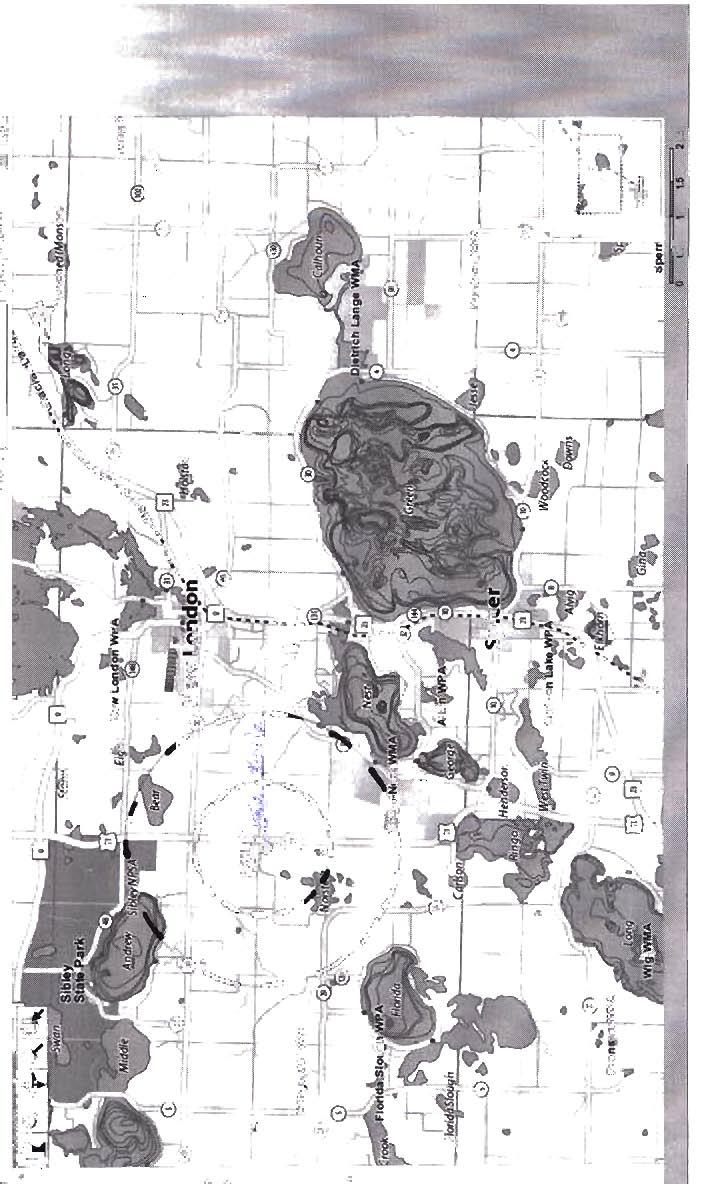
19 24. Odors, noise and dust. Will the project generate odors, noise or dust during construction or during operation? Yes No If yes, describe sources, characteristics, duration, quantities or intensity and any proposed measures to mitigate adverse impacts. Also identify locations of nearby sensitive receptors and estimate impacts on them. Discuss potential impacts on human health or quality of life. (Note: fugitive dust generated by operations may be discussed at item 23 instead of here.) The landfill is located in a rural setting and daily landfill operating hours are as follows. April 1 October 31 Monday Saturday 8:00 a.m. 4:00 p.m. November 1 March 31 Monday Friday 8:00 a.m. 4:00 p.m. Saturday 8:00 a.m. 12:00 p.m. During periods of construction, construction related equipment may be operated from approximately 7:00 a.m. to 7:00 p.m., five to six days a week. The nearest occupied building, Hillcrest Café, is approximately 900 feet away. Noise Noise will be generated during construction and the filling of the cell area. Construction equipment is equipped with muffler exhaust systems to limit impacts. Construction activities will be restricted to daylight hours (7:00 a.m. - 7:00 p.m., Monday through Saturday). Site noise is mitigated by distance, as well as steep berms and a low-lying construction area. A tree line may be of some benefit to reduce the additional noise of construction and development operations. The nearest neighbor is approximately 900 feet from the east edge of the Phase 8, a distance which mitigates noise impacts. 25. Nearby resources. Are any of the following resources on or in proximity to the site? a. Archaeological, historical, or architectural resources? Yes No b. Prime or unique farmlands or land within an agricultural preserve? Yes No c. Designated parks, recreation areas, or trails? Yes No d. Scenic views and vistas? Yes No e. Other unique resources? Yes No If yes, describe the resource and identify any project-related impacts on the resources. Describe any measures to minimize or avoid adverse impacts. According to the DNR recreation compass (Attachment 2) within two miles of the site, Sibley State Park is located to the north and the Ringo-Nest Wildlife Management Area is located to the southeast. There have been no know impacts to these areas to date and no future impacts are expected. New London Township, Minnesota 18
20 26. Visual impacts. Will the project create adverse visual impacts during construction or operation? Such as glare from intense lights, lights visible in wilderness areas and large visible plumes from cooling towers or exhaust stacks? Yes No If yes, explain. In general, existing developed site conditions reduce and eliminate its visual impacts through the construction of a perimeter berm and tree line to the east. Landfill construction and operations may become visible from 165 th Avenue NE to the north where the old landfill entrance used to be. Although landfill construction and operations will be visible from the north end, there are no adjacent private lots, and only cross-traffic through landfill property may have an unrestricted view. Designs to plant fast growing tree stands to the north and west may be included in future development if further study indicates there would be adverse visual impacts. 27. Compatibility with plans and land use regulations. Is the project subject to an adopted local comprehensive plan, land use plan or regulation, or other applicable land use, water, or resource management plan of a local, regional, state or federal agency? Yes No If yes, describe the plan, discuss its compatibility with the project and explain how any conflicts will be resolved. If no, explain. The Kandiyohi County Planning and Zoning map effective March 18, 2005 (Attachment 3), shows the site sits in an A-2 General Agriculture Zone. The land use for do not fall under any known external regulatory rules beyond Kandiyohi County s own zoning policies. Any conflicts with land use or other external restrictions will be handled by the Kandiyohi County Board of Commissioners or the Environmental Services Director. 28. Impact on infrastructure and public services. Will new or expanded utilities, roads, other infrastructure or public services be required to serve the project? Yes No 29. Cumulative potential effects. Minn. R , subp. 7, item B requires that the RGU consider the cumulative potential effects of related or anticipated future projects when determining the need for an environmental impact statement. Identify any past, present or reasonably foreseeable future projects that may interact with the project described in this EAW in such a way as to cause cumulative potential effects. (Such future projects would be those that are actually planned or for which a basis of expectation has been laid.) Describe the nature of the cumulative potential effects and summarize any other available information relevant to determining whether there is potential for significant environmental effects due to these cumulative effects. The proposed project was evaluated to determine if significant cumulative environmental effects exist in the project area or if the project, which may not individually have the potential to cause significant environmental effects, could have a significant effect in combination with other projects. In order to assess the proposed project s cumulative potential effects the MPCA addressed other projects or operations that (1) are already in existence or planned for the future, (2) are located in the surrounding area, and (3) might reasonably be expected to affect the same natural resources. The following is a review of this analysis. New London Township, Minnesota 19
21 Surface Waters Uncontaminated runoff from the landfill area currently drains to the east, towards Nest Lake, which is impaired due to excess phosphorus loading from point and non-point sources of phosphorus in its watershed. With the proposed project, all surface water runoff generated at the site will be directed to on-site sedimentation/infiltration basins though an engineered system of ditches and dikes with surface water drain pipes and erosion prevention materials to manage storm water runoff. The system has been designed to contain all surface water generated at the site; therefore, it is unlikely that the landfill would be a significant source of phosphorus or other pollutant loadings to Nest Lake or contribute to any other cumulative adverse effects on surface waters in the area. Groundwater Quality Groundwater beneath the landfill has been impacted by leachate produced in Phase 1, which was the first portion of the landfill filled in the 1970s. This area was unlined but has been capped with impermeable material. Subsequent filling has been done in lined areas, and there is no evidence that additional groundwater contamination has resulted from these activities. The only known groundwater contamination is from the Phase 1 unlined disposal area. The magnitude of soil and groundwater contamination from Phase 1 is not currently well understood and an investigation within the Phase 1 unlined disposal area was started in 2010 and is under review by MPCA staff. Parts of will be developed on top of portions of the Phase 1 unlined disposal area. Corrective action measures continue to be developed and will be implemented in 2012 with the objective to define and mitigate further impacts to groundwater down-gradient of the landfill. Groundwater monitoring is routinely conducted at a site groundwater monitoring network consisting of 20 monitoring wells on site (Figure 3) and one off-site residential well. Development of the proposed additional phases and cells does not require an expansion of the routine monitoring network. Hydrogeologic investigations performed since 1985 have generated data suggesting that groundwater flowing from beneath the proposed phases locations may be intercepted by the existing monitoring network. Additional groundwater monitoring is also being conducted at 12 corrective action monitoring wells and 2 private wells off-site as part of the overall corrective action monitoring and investigation of contamination from the closed Phase 1 unlined disposal area. Continued corrective action investigations of groundwater contamination prior to and during development of are scheduled to occur to evaluate the need for additional monitoring downgradient of the proposed as necessary. The proposed project comprises waste disposal. This entire area is to be lined with a leachate collection system and will be capped with impermeable materials upon closure. Little, if any, groundwater contamination is expected to result from this project and thus, would add little, if any, additional contamination to the existing plumes. There are no other projects known to exist in the vicinity of the landfill that would be expected to contribute significantly to area groundwater contamination. There are three feedlots located within two miles of the landfill. The feedlots in the area are not likely to significantly impact groundwater as long as they are managed according to regulatory requirements. The development of is not expected to contribute to cumulative effects related to any existing groundwater contamination in the project area. New London Township, Minnesota 20
22 Air Quality Impacts Based on the above, the impacts to air quality associated with the Kandiyohi County landfill are generally associated with odors, fugitive dust, and noise. Odors Odors at a landfill are a function of the disposal area that is open at any one time. The project is a continuation of landfilling activities that have been ongoing for some time, so there is no reason to expect a significant increase in odorous emissions from the project. Odors are minimized through the placement of daily cover materials above the waste and minimizing the length of time the waste is exposed to the open air. Feedlots create odorous emissions as well. As identified above, there are three in the vicinity; the nearest is a turkey feedlot with 900 animal units located about one-quarter of a mile east and the other is a dairy feedlot with animal units less than one mile southwest from the proposed disposal area. Since the winds that carry odors also eventually dissipate them, it is not likely that there would be significant cumulative odorous effects associated with the project. Dust and Noise Dust and noise may be generated by current landfill operating activities. The closure of existing waste cells generally coincides with the opening of new cells, the operating area of the landfill is fairly constant; therefore, the generation of dust and noise is not expected to change significantly. Land Use The land occupied by this project has been defined for many years as the northeast quarter of Section 24, T121N R35W, approximately 11 miles north of the city of Willmar. The project would be implemented within this land parcel and would not involve the occupation of additional land. Three issues have been identified as potentially posing cumulative effects issues with respect to land resources wildlife habitat, row crop agriculture, and traffic. The proposed expansion is not expected to alter the existing conditions in a significant manner with respect to these areas. 30. Other Potential Environmental Impacts. If the project may cause any adverse environmental impacts not addressed by items 1 to 28, identify and discuss them here, along with any proposed mitigation. No other potential environmental impacts have been identified. 31. Summary of issues. List any impacts and issues identified above that may require further investigation before the project is begun. Discuss any alternatives or mitigative measures that have been or may be considered for these impacts and issues, including those that have been or may be ordered as permit conditions. The groundwater plume investigation in progress at the site will evaluate the need for additional monitoring within, under, and downgradient of the Phase 1 disposal area. In the final report for this investigation, recommendations for additional monitoring may be included in construction drawings and technical specifications for development of Phases 7 through 10, if approved by MPCA staff. New London Township, Minnesota 21
23


24
25
26
27


28
29
30
 SYSTEM UNNAMED Public UNNAMED Water Inventory UNNAMED National Wetlands")


31 County Rd 165 NORWAY LAKE ANDREW Legend Landfill Property Boundary Watershed Flow Lines (DNR) SYSTEM UNNAMED Public UNNAMED Water Inventory UNNAMED National Wetlands Inventory Water Sheds Lacustrine Palustrine Upplands UNNAMED UNNAMED UNNAMED BEAR Hydrologic Units UNNAMED Nest Lake-Middle Fork Crow River Lake Florida EIGHT UNNAMED Miles µ EIGHT UNNAMED UNNAMED UNNAMED UNNAMED UNNAMED UNNAMED UNNAMED LAKE FLORIDA CEDAR ISLAND UNNAMED CLOSED DISPOSAL AREA 71 PROPOSED 7 & 8 MSW DISPOSAL AREA UNNAMED UNNAMED 71 OPEN MSW DISPOSAL AREA OPEN C&D DISPOSAL AREA NORSTEDT UNNAMED NEST LAKE-MIDDLE FORK CROW RIVER UNNAMED UNNAMED File Name: Figure 8 - Watershed.mxd FLORIDA ECADengineering.com KANDIYOHI COUNTY LANDFILL, SW-79 NEW LONDON, MINNESOTA ENG/SCI: DATE: NEST FIGURE 8 WATERSHED AND SURFACE WATER RECEPTORS (MARCH 2010)


32 ATTACHMENT 1 Minnesota Department of Natural Resources Division of Ecological Resources, Box Lafayette Road Sl Paul, Minnesota W25 Phone: (651) February 5, 2010 Correspondence # ERDB Eric Sanderson Environmental Concepts and Design, Inc. 90S Jefferson Avenue, Suite 210 $1. Paul, MN RE: Natural Heritage information in the vicinity of the proposed Kandiyohi County Sanitary Landfill Development, Phases 7 10; T121N R35W Section 24 Dear Mr. Sanderson, As requested, the Minnesota Natural Heritage Information System has been queried to determ ine if any fare species or other significant natural features are known to occur within an approximate one-mile radius of the proposed project. Based on this query, prairie remnants have been documented within the search area (for details, see the enclosed database reports). In addition to those listed on the database reports, the MinnesotaCounty Biological Survey (MCBS) has identified a Dry Sand - Gravel Prairie immediately west of the landfill. This prairie is within an area identified by the MeBS as a Site of Moderate Biodi versity Significance (please see the enclosed map; GIS shapefiles of MCBS Sites of Biodiversity Significance and MeBS Native Plant Communities can be downloaded from the DNR Data Deli at hnp:lldeli.dnr.stale.mn.us). Sites of Biodiversity Significance have varyi ng levels of native biodiversity and are ranked based on the relative significance of this biodiversity at a statewide level. Sites ranked as Moderate contain occurrences of rare species and/or moderately disturbed native plant communities, and/or landscapes that have a strong potential for recovery. This particular Site includes the area north of the prairie, even though the area north of the prairie does not meet the definition of a native plant community. As proposed, the project will include excavation oftopsoi! and mineral soils for landfi ll cover within the above prairie remnant. Thi s type of prairie has a State Rank of2, meaning that it is imperiled in the state of Minnesota. In the mid- ISOOs, eighteen million acres of prai rie covered Minnesota. Since then. more than 99% of this native prairie has been destroyed and the I % that remains consists mostly of widely scattered fragments that are surrounded by agriculture and development. Due to the loss of thi s once widespread habitat many prairie-obligate species have become rare; more than one-third of Minnesota's endangered. threatened, and special concern species are dependent on the remaining small fragments of Minnesota's prairie ecosystem. Given the rarity of this native plant community and the potential forstate-listed species to occur within it, the DNR recommends avoidance of all native prairie remnants. Ideally, the entire Site of Biodiversity would be avoided as even the disturbed areas contribute to the overall habitat matrix. However, if thi s is not feasible. limiting the excavation to the north of the prairie would at least protect the prairie. Please contact me if the native prairie remnant will be impacted, as a rare species survey may be required. We will need to discuss potential surveyors. survey protocol, and other requirements before any survey work is initiated. Item 11 b in the should describe the Site of Biodiversity Significance and the prairie within it, and detail how they may be impacted by the proposed project. It should also describe any proposed avoidance or mitigation measures and, if applicable, it should document why avoidance is not feasible. The Narum! Heritage Infonnation System (NHIS), a collection of databases that contains infonnation about Minnesota's rare natural features. is maintained by the Division of Ecological Resources, Department of DNR Information: fl a367 TTY: An Equal Oppoounity Employer Wlo Values Diversity
33 Natural Resources. The NH IS is continua1ly updated as new information becomes available, and is the most complete source of data on Minnesota's rare or otherwise signi ficant species, native plant communities, and other natural features. However, the NHIS is not an exhaustive inventory and thus does not represent all of the occurrences of rare features within the state. Therefore, ecologically significant features for which we have no records may exist withi n the project area. The enclosed results include an Index Report of records in the Rare Fearures Database, the main database of the NHI S. This report is copyrighted, but may be reprinted, unaltered, in the EA W. If you wish to reproduce the index report for any other purpose, please contact me to request written permission. This letter does not constitute review or approval by the Department of Natural Resources as a whole. Instead, it identifies issues regarding known occurrences of rare features and potential effects to these rare features. Additional rare features for which we have no data may be present in the project area, or there may be other natural resource concerns associated with the proposed project. For these concerns, please contact your DNR Regional Ecologist, Kevin Mixon, at Please be aware that additional site assessments or review may be required. Thank you for consulting us on this maner. and for your interest in preserving Minnesota's rare natural resources. An invoice will be mailed to you under separate cover. Sincerely, Lisa Joyal Endangered Species Environmental Review Coordinator enc. Link: cc: Rare Features Database: Index Report Rare Features Database: Detail Report Rare Features Database Reports: An Explanation of Fields Map hnp;!lfiies.dnr.stale.mn.uslnatural resourcesjnpcjupland prairie/upsi3.pdf Kevin Mixon
34 The Division of Ecological Resources recently adopted a new database system called Biotics. As a result of this change. the layout and contents of the database reports have been revised. Many of the fie lds included in the new reports are the same or similar to the previous report fields, however there are several new fi elds and some of the fi eld definitions have been slightly modified. We recommend that you fami liarize yourself with the latest field explanations. Rare Features Database Reports: An Explanation of Fields The Rare Features Database (Biotics) is pan of the Natural Heritage Infonnation System, and is maintained by the Division of Ecological Resources, Minnesota Depanment of Natural Resources (DNR)., "Please note that the print-outs are copyrighted and may not be reproduced without permission Field Name: 1 Full (non-abbrevialed) field name, if different). Further n planation of field. -E- Element Name and Occ II: [Elemen! Name and Occurrence Number]. The Elemen! is the name of the rare feature. For plan! and animal species records, this field holds the scientific name fo llowed by the common name in paren!heses; for all other elements (such as nati ve plant communities, which have no scientific name) it is solely the element name. Native plant community names correspond to Minnesota's Native Plant Community Classification (Version 2.0). The Occurrence Number, in combination with the Element Name, uniquely iden!ifies each record. EO Data: [Element Occurrence Data]. For species elements, this field contains data collected on the biology of the Element Occurrence' (EO), including the number of individuals, vigor, habitat, soi ls, associated species, peculiar characteristics, etc. For native plan! community elements, this field is a summary text description of the vegetation of the EO, including structure (strata) and composition (dominant/characteristic species), heterogeneity, successional stage/dynamics, any unique aspects of the community or additional notewonhy species (including animals). Note that this is a new field and it has not been filled out for many of the records that were collected prior to conversion to the new database system. Some of the information meeting the field definition may be found in the General Description field. fq..ll.m: [Element Occurrence Identification Number]. Unique identifier for each Element Occurrence record. EO Rank: [Element Occurrence Rank]. An evaluation of the quality and condition of an Element Occurrence (EO) from A (highest)to 0 (lowest). Represents a comparative evaluation of: I) quality as determined by representativeness of the occurrence especially as compared to EO specifications and including maturity, size. numbers. etc. 2) condition (how much has the site and the EO itself been damaged or altered from its optimal condition and character). 3) viability (the long-term prospects for continued existence of this occurrence used in ranking species only). EO Ranks are assigned based on recent fieldwork by knowledgeable individuals. Extent Known?: A value that indicates whether the full extent of the Element is known (i.e., it has been determined through field survey) at that location. Ifnull, the value has not been determined. -Ffederal Status: Status of species under the U.S. Endangered Species Act: LE = endangered; L T "" threatened; LE,L T = listed endangered in part ofits range. listed threatened in another part of its range; L T,POL = listed threatened. proposed for delisting; C = candidate for listing. If null or "No StatuS" the species has no federal status. First Observed oate: Date that the Element Occurrence was first reponed at the site in formal YYYY -MM DO. A year followed by " Pre" indicates that the observed date was sometime prior to the date listed. but the exact date is unknown. -G- General DescriDtion: General description or word picture of the area where the Element Occurrence (EO) is located (i.e.. the physical setting/context surrounding the EO), including a list of adjacent communities. When available, information on surrounding land use may be included. Note that the information rracked in this fi eld is now more narrowly defined than it was in the old database system. and some of the information still in this field more accurately meets the definition of the new EO Data field. We are working to clean up the records so that the information in the two fi elds corresponds to the current fie ld explanations described herein. Also note that the use of uppercase in sentences in this field is not significant but rather an artifact of transferring data from the old database system to the new system. Global Rank: The global (i.e., range-wide) assessment of the relative rarity or imperilment of the species or community. Ranges from G I (critically imperiled due to extreme rarity on a world-wide basis) to G5 (demonstrably secure, though perhaps rare in pans of its range). Global ranks are determined by NatureServe, an international network of natural heritage programs and conservation data centers. -L- Last Observed D~: Date that the Element Occurrence was last observed to be extant at the site in format YYYY -MM-DD. Last Survey Date: Date of the most recent field survey for the Element Occurrence. regardless of whether it was 'found during the visit. If the fi eld is blank, assume the dale is the Same as the Last Observed Date.
35 Location!?escriDljon; Counl)' or Counties in which the Element Occurrence was documented followed by Township, Range, and Section information (not listed in any particular order). Each unique Township, Range, and Section combination is separated by a comma. [n some cases, there are too many Township, Range, and Section combinations to list in the field, in which case, the information will be replaced with, "Legal description is too lengthy to fit in alloned space". -M - Managed Area(s); Name of the federally, state, locally, or privately managed park, forest, refuge, preserve, etc., containing the occurrence, if any. If this field is blank, the element probably occurs on private land. If~(5tatulOry Boundary)" occurs after the name of a managed area, the location may be a private inholding within the statutory boundary of a state forest or park. MN Status; [Minnesota Status]. Legal status of plant and animal species under the Minnesota Endangered Species Law: END = endangered; TI-lR = threatened; SPC " special concern; NON = tracked, but no legal status. Native plant communities, geological features, and colonial waterbird nesting sites do not have any legal status under the Endangered Species Law and are represented by a NI A. -N- Nrc Classification (v l.s): Native plant community name in Minnesota's Native Vegetation; A Key 10 Natural Communities (Version 1.5). This earlier classification has been replaced by Minnesota's Native Plant Community Classification (Version 2.0)..(). Observed Area: The total area of the Element Occurrence. in acres, which is measured or estimated during fieldwork. [fnull, the value has not been determined. Ownership Type: Indicates whether the land on which the Element Occurrence was located was publicly or privately owned; for publicly owned land. the agency with management responsibility is listed. if known. -S- Site Name: The name of the sitc(s) where the Element Occurrence is located. Sites are natural areas ofland with boundaries determined and mapped according to biological and ecological considerations. Survey Site #/Name: The name of the survey site, if applicable, where the Element Occurrtnce is located. Survey sites are sites that provide a geographic framework for recording and storing data, but their boundaries are not based on biological and ecological considerations. Minnesota County Biological Survey site numbers, if applicable, are also listed in this field. Survey Type: Information on the type of survey used to collect information on the Element Occurrtnce. Surveyor(s): Name(s) of the person(s) that collected survey information on the Element Occurrence. State Rank: Rank that best characterizes the relative rarity or endangerment of the taxon or plant community in Minnesota. The ranks do not represent a legal status. They are used by the Minnesota Department of Natural Resources to set priorities for research. inventory and conservation planning. The state ranks are updated as inventory information becomes available. SI = Critically imperiled in Minnesota because of extreme rarity or because of some factor(s) making it especially vulnerable to extirpation from the stale. S2 = Imperiled in Minnesota because of rarity or because of some factor(s) making it very vulnerable to extirpation from the state. S3 = Vulnerable in Minnesota either because rare or uncommon, or found in a restricted range, or because of other factors making it vulnerable to extirpation. 54 = Apparently secure in Minnesota, usually widespread. 55 '"" Demonstrably secure in Minnesota, essentially ineradicable under present conditions. SH = Of historical occurrence in the state, perhaps having not been verified in the past 20 years, but suspected to be still extant. An element would become SH without the 20-year delay if the only known occurrences in the state were destroyed or if it had been extensively and unsuccessfull y looked for. SNR = Rank notyel assessed. SU = Unable to rank. SX = Presumed extinct in Minnesota. SNA = Rank not applicable. S#S# = Range Rank: a numeric range rank (e.g., S253) is used 10 indicate the range ofuncenainty about th ~ ~ xac t status of the element. S#B. 5#N "" Used only for migratory animals. whereby B refers to the breeding population of the element in Minnesota and N refers 10 the non-breeding population of the element in Minnesota. -v- Vegetation Plol: Codc(s) for any vegetation plot data that have been collected within this Element Occurrence (i.e., either Releve Number or the word ;;RELEVE" indicates that a releve has been collected). Element Occurrence ~ an area of land andlor water in which an Element (i.e., a rare species or community) is, or was, present, and which has practical conservation value for the Element as evidenced by potential continued (or historical) presence andlor regular recurrence at a given location. Specifications for each species determine whether multiple observations should be considered I Element Occurrence or 2, based on minimum separation distance and barriers to movement. Data Security Locations of5oolc rate feanu-es I11 US1 be trei\ied lis sensitive Informlltlon because "'idc:spread knowledge of these lck:alions could resull In Iwm 10 the rare fea1ures For example.... 'Idna..'el'$ $loch lis orchids and economically val lillble planls such as ginseng ale vulnerable to explonatlon by eoil«1oi's: other Sjle(1e5. such as bald eagles. arc sensit ive to disturbance by observers. For th is reason. we prefer that publications 00( idcntij)< the precise locatlolls of vul nerable SpecIes. We suggesl describing the location onl y to the nearest section. [fth,s is not ac:ccptable for your purposes. please call and discuss this issue with the Endangered Spttles EnVIronmen tal Revle... Coordinator at (6SI)2S9-S t09.


36 ATTACHMENT 2 il i I 1 [3 I, I < 0 l I >- I '7~ -t t i - i - I i i

' D,Ic:.bu -H+ Railroad!: Orb.. Q-owth B... d..,. I alllt'l, ~ o N A Kandiyohi County Planning & Zoning 2,500,- IOPCO")
37 Lake Andrew Township Zoning Districts ATTACHMENT 3 19 I ; 25 8 ~ ZUllilfg D ;',rw;a o A-I Aar.eultllrll Prenr... aca A-2 OCIIHII Ajncu!Mc -- RIven ~ Slnm.. R-MJ.uoun:c SIoOlld_dld_.=eat R-\ Shonl.. dj.ullxllul R 2 Comm\IIU1)' aollcleo.co C-I C... urc... IIaO:. Ulnal _.- CoWll)' D,Ic:.bu -H+ Railroad!: Orb.. Q-owth B... d..,. I alllt'l, ~ o N A Kandiyohi County Planning & Zoning 2,500,- IOPCO