RATCH-Australia. 15 February Collector Wind Farm. Traffic and Transport Assessment
|
|
|
- Dinah Hunt
- 5 years ago
- Views:
Transcription

1 RATCH-Australia Traffic and Transport Assessment
2 Traffic and Transport Assessment Prepared for RATCH-Australia Prepared by AECOM Australia Pty Ltd Level 21, 420 George Street, Sydney NSW 2000, PO Box Q410, QVB Post Office NSW 1230, Australia T F ABN AECOM in Australia and New Zealand is certified to the latest version of ISO9001 and ISO AECOM Australia Pty Ltd (AECOM). All rights reserved. AECOM has prepared this document for the sole use of the Client and for a specific purpose, each as expressly stated in the document. No other party should rely on this document without the prior written consent of AECOM. AECOM undertakes no duty, nor accepts any responsibility, to any third party who may rely upon or use this document. This document has been prepared based on the Client s description of its requirements and AECOM s experience, having regard to assumptions that AECOM can reasonably be expected to make in accordance with sound professional principles. AECOM may also have relied upon information provided by the Client and other third parties to prepare this document, some of which may not have been verified. Subject to the above conditions, this document may be transmitted, reproduced or disseminated only in its entirety.

3 Quality Information Document Ref Date Prepared by Reviewed by Parish Chandra Nick Bernard Revision History Revision Revision Authorised Details Date Name/Position A 30-Nov-2010 Draft report Dan Bright Associate Director B 17-Dec-2010 Revised draft report Dan Bright Associate Director C 26-Jan-2011 Final draft report Dan Bright Associate Director D 14-Feb-2011 Final report Dan Bright Associate Director E 28-Feb-2011 Revised final report Dan Bright Associate Director F 22-Mar-2011 Revised final report Dan Bright Associate Director G 24-Jan-2012 Revised final report Andy Yung Principal Consultant H 15-Feb-2012 Updated final report Andy Yung Principal Consultant Signature Original signed Original signed Original signed Original signed Original signed Original signed Original signed
4 Table of Contents Executive Summary i 1.0 Introduction Planning Context State and Regional Strategic Planning Policies Local Environmental Plans Standards and Guidelines Existing Conditions Site Location Road Network Existing Traffic Volumes Accident History Public Transport Proposed Development Description Access Arrangements Transport Impacts Construction Phase Operational Phase Restrictions and Approvals Over Dimensioned Vehicle Permits General Operating Requirements Rehabilitation of Public Roads used as Access Roads Conclusions and Recommendations Conclusions Mitigation and Management Measures 19 Appendix A Accident History Appendix B Vehicle Swept Paths A A B B
5 i Executive Summary RATCH-Australia is seeking to develop a wind energy facility (wind farm) north west of Collector Village, within the Upper Lachlan Shire Council Local Government Area (LGA). The proposed would consist of up to 68 wind turbine generators (WTGs). Other associated infrastructure includes access roads, internal and underground cabling, control buildings, substation, grid connection, monitoring masts and temporary construction facilities. This report considers the traffic impact of the proposed development during construction and during operation of the facilities and has concluded that the impact on the strategic road network of the traffic generated is likely to be minimal, and will mainly be during the construction stage. The project is likely to generate a maximum traffic demand of approximately 110 staff vehicles and 30 trucks per day during the construction stage (for both road upgrade and WTG construction), with a worst case scenario of 56 trucks per day during concrete pouring periods. The impact of the construction traffic generated by the site along the truck route in terms of capacity is likely to be minimal, aside from the local access road (Lerida Road South), which will have a relatively large impact due to the low existing traffic on the road. Lerida Road South will require to be upgraded (to unsealed road class U1) to accommodate the construction vehicles. The impact of the additional traffic on the Lerida Road South/Hume Highway intersection level of service is expected to be minimal; however, there will be safety impacts due to the large construction vehicles turning across the Hume Highway at the intersection, therefore construction traffic control is required at the Lerida Road South entry and exit. Oversize vehicles used to transport materials to site will require an Over Dimensioned permit from the Roads and Maritime Services (RMS) and the police should be contacted for movement of the oversize vehicles. Based on indicative swept path analysis, some pavement widening and possible temporary relocation of roadside infrastructure may be required at the Lerida Road South/Hume Highway intersection, at the Mount Ousley Road intersection with Picton Road, and at the Hume Highway off-ramp joining Picton Road. The following mitigation and management measures are proposed to reduce the impact of the development on the local road network: - For safety reasons, the Lerida Road South entry and exit should have traffic control in place. Adequate signage should be displayed to inform motorists of the approach to the intersection for construction traffic turning. This should all form part of a Traffic Control Plan (governed by Australian Standard AS ) for the construction phase of works, which will also cover the upgrade of the Crown roads and the Lerida Road south intersection upgrade to accommodate the oversize vehicles; - Large oversize materials should be transported outside of peak traffic times to reduce impacts on road network (subject to RMS approval); - Once more detail is known around the exact vehicles and routing, then more detailed swept path analysis should be undertaken along the truck route; - Cattle bridges on Lerida Road South and farm roads / Crown roads will need to be removed during construction. The internal roads in the site are required to be widened to 8m in order to transport the construction materials and the large turbines to the desired location, and will require surfacing upgrade through grading. This will need to be co-ordinated with the landowners and farmers; and - The road and intersection conditions should be established by the use of field surveys and regular site inspections. When required, rehabilitation of the pavement and/or edges of seal, shoulders and verges should be carried out. At the completion of the works the access roads should be in the same or superior condition than at the commencement of the works.
6 1 1.0 Introduction RATCH-Australia is seeking to develop a wind energy facility (wind farm) north west of Collector Village, within the Upper Lachlan Shire Council Local Government Area (LGA). The proposed would consist of up to 68 wind turbine generators (WTGs). Other associated infrastructure includes access roads, internal and underground cabling, control buildings, substation, grid connection, monitoring masts and temporary construction facilities. This report considers the traffic impact of the proposed development during construction and during operation of the facilities. The study will evaluate potential traffic flows, identify road limitations and assess capacities, and provide recommendations relating to road access and safety performance, where necessary. This report is divided into the following sections: - Chapter 2 presents the transport planning context of the site and activities; - Chapter 3 illustrates the existing conditions of the relevant road network; - Chapter 4 describes the proposed development; - Chapter 5 provides the transport impacts of the proposed development; - Chapter 6 presents the restrictions and approvals that may affect the construction of the wind farm; while - Chapter 7 provides conclusions and recommendations as a result of the study.
7 2 2.0 Planning Context 2.1 State and Regional Strategic Planning Policies A number of state and regional planning policies, at various stages of development, relate to this type of development State Plan (NSW 2021) (NSW Department of Premier and Cabinet, September 2011) Purpose: NSW 2021 is the NSW Government s 10-year plan to guide policy and budget decision making. It sets long-term goals with measurable targets. Content relating to traffic and relevance to the Project: Goal 22 Protect our Natural Environment presents the target of increasing renewable energy to 20% by It proposes to do this through a more diverse energy mix, reducing coal dependence, increasing energy efficiency and moving to lower emission energy sources State Infrastructure Strategy (NSW Treasury, June 2008 / Infrastructure NSW, 2012) Purpose: The State Infrastructure Strategy produced in 2006, and updated in 2008, linked the four-year capital Budget contained in the Infrastructure Statement (Budget Paper No. 4) with the 25 year long term planning strategies, like the Metropolitan Strategy. The strategy set out the infrastructure budget with agency plans for various government departments and agencies and regional infrastructure plans, covering areas such as strategic planning and development and public transport. Infrastructure NSW is currently working with the NSW Government in developing an updated 20-year State Infrastructure Strategy. The final strategy, which will be released in the second half of 2012, will identify what infrastructure the state needs to achieve economic growth and how to activate both public and private sector resources to deliver it. Content relating to traffic and relevance to the Project: The 2006 Strategy identified a major road project along the proposed construction route at the Hume Highway bridge at Paddy s River. Any further infrastructure upgrades that may be relevant to this development are to be confirmed in the 2012 release of the Strategy Sydney-Canberra Corridor Regional Strategy (NSW Department of Planning, 2006) Purpose: The Sydney-Canberra Corridor Regional Strategy applies to the local government areas of Wingecarribee, Goulburn Mulwaree, Upper Lachlan, Yass Valley, Palerang and Queanbeyan. The strategy represents an agreed NSW Government position on the future of the Sydney-Canberra Corridor. The primary purpose of the Regional Strategy is to accommodate and manage growth while ensuring that the rural landscapes and environmental settings that define the Region s character are not compromised. It will do this by ensuring that land is available and appropriately located to sustainably accommodate the projected population growth and associated housing, employment and environmental needs over the period until Content relating to traffic and relevance to the Project: The strategy states that the Region continues to be recognised as a nationally important route for the movement of people, services, goods and information. In particular the role of the Hume, Federal and Barton highways as part of the national highway system and the Main Southern Railway as part of the national rail system are recognised and protected. The Ministry of Transport, the Roads and Traffic Authority (now the Roads and Maritime Services) and RailCorp will develop strategies to identify future improvements to the capacity of roads and rail and bus services to cater for population growth and to identify infrastructure investment opportunities NSW Long Term Transport Master Plan (Transport for NSW, 2012) Purpose: The NSW Long Term Transport Master Plan will address key transport challenges facing the State over the next 20 years including population growth, employment and increased demand for transport infrastructure. It is currently in development and consultation and should be released in November 2012.
8 3 2.2 Local Environmental Plans Upper Lachlan Development Control Plan (Upper Lachlan Shire Council, September 2011) Purpose: Upper Lachlan Shire Council has established a development control plan (DCP) for commercial wind farm developments, which contains a series of planning and environmental controls for these projects Content relating to traffic and relevance to the Project: With regards to traffic and transport associated with the development of wind farms, the DCP states that: - Construction vehicles, including concrete trucks, carriers of turbine components, and related heavy vehicles (including relevant contractors) shall only travel on an approved route. This route shall be identified and approved in accordance with the DCP. - Council requires investigations into impact of construction vehicles on the proposed route. Detailed road condition reports will be required as part of any consent. Council requires the use of the ARRB laser car and gypsy camera for this purpose; - Council will require road works to cope with the over size and overweight traffic movements related to the construction of a wind farm. Bonds will also be required for any potential damage to roads during the construction phase. Where road works are determined necessary for the development, costs associated with the road works shall be the developer s responsibility; - Construction and maintenance of internal roads (roads within the property subject to the development) shall be the responsibility of the developer. Council will require proof that they have been adequately designed and constructed for their purpose; and - Within six months of the wind turbine generators ceasing to operate, any rights of carriageways that were created to enable maintenance to be conducted on the wind turbine generators are to be extinguished by the developer and the land made good, unless otherwise agreed with the landowner. 2.3 Standards and Guidelines RMS (formerly RTA) Guide to Traffic Generating Developments The RMS Guide to Traffic Generating Developments outlines all aspects of traffic generation considerations relating to developments. The information provided gives background into the likely impacts of traffic from various types of development. The guide provides a section on various land use traffic generation and a section on interpretation of traffic impacts. The impact on traffic efficiency and safety has been considered as part of this study Austroads Guide to Pavement Technology, Part 6: Unsealed Pavements The Guide to Pavement Technology, Part 6: Unsealed Pavements contains guidance that provides road designers and other practitioners with information on pavement configurations and classifications for unsealed roads. This is principally based on the volume of daily traffic, the composition of the traffic (e.g. road trains), and accessibility and remoteness issues: pavement configurations vary from two-lane, multiple granular layers and shoulders constructed over the subgrade, to a single lane shaped subgrade. For this study, the type of unsealed road required for volume and type of construction and operational traffic has been assessed.


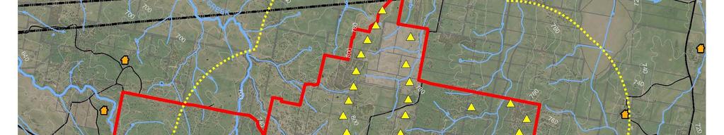
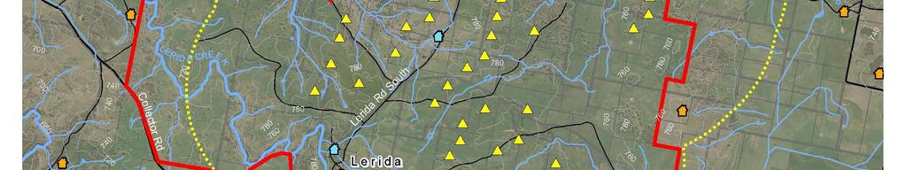
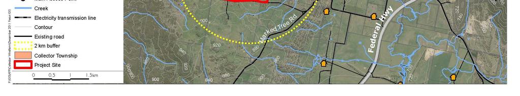
9 4 3.0 Existing Conditions 3.1 Site Location The site is located 55km northeast of Canberra and 35km southwest of Goulburn as shown in Figure 1. The site lies within the NSW Government s NSW/ACT Border Region Renewable Energy Precinct. The project site is 6,215ha, with a development envelope of 800ha. It is bounded by the Hume Highway to the north, Collector Road to the west and south, and Collector Creek to the east. Lake George lies 8km to the south of the site and the Cullerin Wind Farm is situated immediately to the north. Access to the site is proposed from the Hume Highway at the Lerida Road South intersection. Figure 1: Proposed Site of
10 5 3.2 Road Network The two major functions of the road network are to provide access to development and enable safe and efficient movement of goods and people. The following roads would be directly impacted by the proposed development, mainly during the construction period Hume Highway The Hume Highway is a major link connecting Sydney with Melbourne and is a vital link for road freight to transport goods to and from the two cities. The Hume Highway is a four lane, two-way, divided carriageway which connects to Lerida Road South (a main local road) to the north of the proposed site. It is signed at 110km/h Lerida Road South Lerida Road South provides a direct link through the proposed site between the Hume Highway and Collector Road, running north-south. Lerida Road South is currently an unsealed Crown road. There are other short sections of Crown road that run off of Lerida Road South that would provide access to the WTG sites. The road is signed at 100km/h. The following roads will be affected by the proposed development due to the movement of the large wind turbine parts from Port Kembla, the nearest port Picton Road Picton Road is a two lane, two-way undivided sub-arterial road which functions as the main east-west connection between the Hume Highway and Mount Ousley Road. It is signed at 90km/h Southern Freeway / Mount Ousley Road The Southern Freeway/ Mount Ousley Road serves as a vital link for road freight to transport goods to and from Port Kembla. The road is signed at km/h 3.3 Existing Traffic Volumes The Annual Average Daily Traffic experienced on the major road s are presented in Table 1. The AADT data is from the RMS traffic count sites. The count site locations are presented in Figure 2. Table 1 Annual Average Daily Traffic Site Location ** ** Hume Highway (W of Federal Hwy) 7,147 6,508 6,873 7,543 7,565 7,502 7,312 7,431 Hume Hwy (S of Illawarra Hwy) 18,612 18,447 19,835 20,250 20,772 20,105 20,235 20,846 Picton Road (W of Princess Hwy) 11, , , ** Permanent Count Stations Source: RMS Traffic Volume Data
 was undertaken on the section of the Hume Highway from Goulburn to Gunning.")
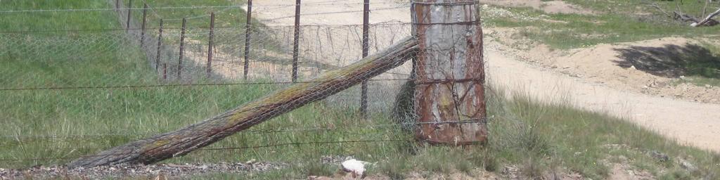
11 6 Figure 2 RMS Count Sites Location Source: Google Maps and AECOM 3.4 Accident History Analysis of accident data from the RMS crash database ( ) was undertaken on the section of the Hume Highway from Goulburn to Gunning. The analysis revealed a total of 256 crashes over the 5 years, with eight casualties and 95 injuries. The analysis further revealed that out of the total 256 crashes, 72% involved cars and 31% involved heavy trucks. Speeding (31%) and fatigue (21%) were listed as the main reasons for crashes. Weather conditions when the crashes took place were mostly fine (64%) and the road surface was dry (73%). In the vicinity of the proposed site access intersection (Hume Highway / Lerida Road South), there have been a total of seven crashes, involving two injuries and four casualties. The crashes mainly involved a vehicle going off the road on a curve and hitting an object on the side. The complete crash report and location map is presented in Appendix A. Picton Road, which connects Port Kembla to Hume Highway and will serve as a major road for transporting goods to the site, has a high accident history with 22 fatalities in the past decade. 3.5 Public Transport No public transport operates within the vicinity of the site; however, a school bus route operates along the south of the site on Collector Road. The school bus service operates on school days only for the duration of the school year.
12 7 4.0 Proposed Development 4.1 Description The wind farm is expected to comprise up to 68 wind turbine generators (WTG). Variables which will determine the final layout of the wind farm include wind resource, proximity to residences, environmental conditions and constructability. The following sections provide a brief overview of the various components of the wind farm: Monitoring Masts Three permanent wind monitoring masts would be installed for the operational phase to allow performance monitoring of the WTG output. The permanent masts would extend 80-90m above ground level Hardstands and Foundations At each WTG site, a hardstand approximately 2,500 sqm in size would be established for crane operations during the erection of the towers and WTG components. The hardstands would be maintained throughout the operational phase to permit scheduled maintenance activities Wind Turbine Generators (WTGs) The general characteristics of each WTG would include: - Three-bladed design with a maximum blade length of 56 metres; - Turbine capacity up to 3.4MW; m cylindrical steel towers; and - Total height (to blade tip) of m Electrical Works Site electrical works would comprise the following: - A medium voltage transformer; - Underground electrical cabling and control cables linking each WTG to the substation and control room, respectively; and - A wind farm substation. Figure 3 shows the indicative wind turbine layout, comprising 68 potential WTG locations.


13 AECOM Figure 3 Preliminary Wind Turbine Layout Source: APP,


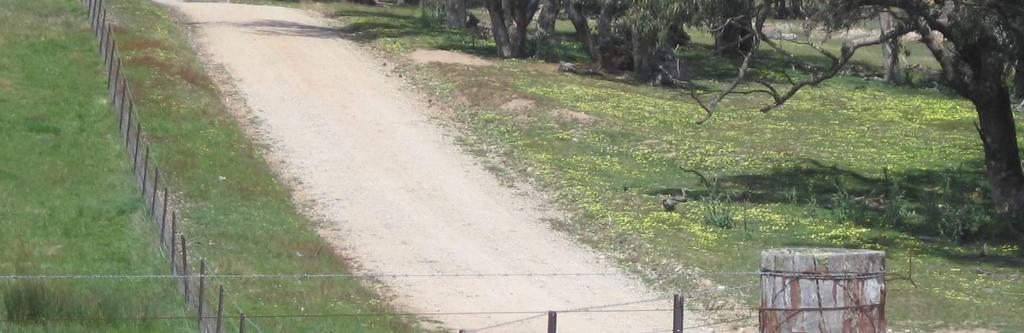
14 9 4.2 Access Arrangements External Access Due to the geometric and topographic constraints on Collector Road, the external access to the site is proposed from the northern section of the site at the Hume Highway / Lerida Road South intersection. This is a give way intersection with priority to through traffic on the Hume Highway. Figure 4 shows the access to the site from the Hume Highway, looking west. Figure 4 Site Access Hume Highway / Lerida Road South intersection Proposed Truck Route to the Site from Port Kembla It is assumed that most of the wind turbine parts will be transferred to the site from Port Kembla. There are two possible routes to access the site from Port Kembla: 1) via Picton Road; or 2) via Illawarra Highway. The route via the Illawarra Highway has a hilly terrain with a number of sharp bends and turns, therefore the route via Picton Road is the preferred option. Picton Road is also an approved B-double route. The proposed truck route from Port Kembla is along the Southern Freeway / Mount Ousley Road, Picton Road, Hume Highway and Lerida Road South. Figure 5 shows the proposed route from Port Kembla to the site.

15 10 Figure 5 Proposed truck route from Port Kembla to Site Source: Google Maps and AECOM Internal Access On-site access roads would connect each WTG site. Where possible existing farm tracks / Crown roads would be utilised; however it is likely that these roads would require upgrading to handle the construction loads. Where existing roads/tracks are not available, access routes would be chosen based on engineering requirements, optimal access for construction and operation, and avoidance of native vegetation. For the construction phase, access roads/tracks would need to be up to 8m wide to allow access for larger equipment (e.g. mobile cranes). The operational phase access requires a 6m formed width.

16 Transport Impacts The traffic impact will be concentrated at the entry point of the site from the Hume Highway at Lerida Road South. The traffic impact of the trucks carrying large materials to the site will be on the entire route from Port Kembla to the site impacting traffic on Mount Ousley Road / Southern Freeway, Picton Road and Hume Highway. 5.1 Construction Phase The transport of materials and equipment to the site during the construction phase would involve a temporary increase in the local traffic volume and the transport of oversize loads. The general construction activities involved are likely to include: - Construction of the internal access tracks to the wind turbine locations, - Stripping and stockpiling of topsoil, - Foundation investigations at the wind turbine locations, - Excavation and construction of the foundations and hardstands for the wind turbines, - Excavation and construction of the operations building and switchyard, - Erection of the wind turbines towers, turbines and rotor blades, - Installation of underground cabling, and - The reinstatement of the site. Figure 6 shows an indicative program of works for the establishment of the. A 24 month construction period is proposed. Figure 6 Indicative Program of Works Source: APP, 2010 There are three main traffic-intensive elements of work, namely upgrading of the access roads, concrete pouring of the foundations and the transporting of the WTG parts. It is proposed that these three elements are staged so as to avoid overlapping, thereby reducing the traffic impact. The upgrading of Lerida Road South and Crown roads can be commenced during the pre-construction stage. The volume of traffic from the concrete pours, transport of WTG parts and construction personnel have been calculated first to assess the extent of the road upgrades required.
17 Traffic Generation Wind Turbine Generators (WTGs) The material components will need to be transported to site, most likely from Port Kembla. The components would include the tower sections, blades, turbines, kiosk transformers, steel reinforcing (for the foundations), and substation components (including 2 x 130 MVA transformers). The towers will be delivered in three sections (approximately 30m in length each) transported on extended articulated trucks. A heavy-duty articulated truck could deliver the turbine assemblies. A-double trucks (total length 36.2m) may be suitable. The blades are to be a maximum length of 56m, requiring a maximum truck length of approximately 60 m for transportation. Each turbine has three blades requiring three trucks per turbine to transport the blades. Only one over-dimensioned truck would arrive at site at one time, with blades to be stockpiled at the individual turbine sites. Concrete Pours There are two options for concrete production one with a concrete batching plant located on-site, with aggregate sourced locally, and the other with no concrete batching plant and the use of concrete mixer trucks. For the latter scenario, in terms of the volume of concrete required for the project, the best case (based on the use of rock anchor footings) would be 100m 3 per turbine for 68 turbines. However, a worst case scenario (based on the use of gravity footings) has been used for this assessment, which would be 450m 3 of concrete per turbine for 68 turbines. This equals 31,000m 3 and is considered enough to cover the concrete required for all of the infrastructure (substation compound, hardstand and turbine footings included). This equates to approximately 3,880 concrete mixing trucks for the 68 turbines. The construction vehicles to the site are outlined in Table 2. These estimates are based on 68 turbines being constructed and is considered the worst case scenario. Table 2 Construction vehicles visiting the site Material No. of Construction Trucks Scenario 1 (concrete batching plant) Scenario 2 (no concrete batching plant) Tower Sections Turbines Blades Hubs/cables/controllers Steel reinforcing Concrete mixer trucks - 3,880 Sand and aggregate 1,292 - Cement Water tankers TOTAL 2,312 4,730 To determine the impacts for a worst case scenario, it has been assumed that approximately 4,730 trucks are required during the construction phase. Most of the trip generation will occur during the 18 month construction stage. If 68 turbines are constructed over the 18 month construction stage, and assuming approximately 300 working days per year, there would be 11 trucks accessing the site per day on average. This will generate 22 truck movements throughout the day. However, during a concrete pour there may be more of a peak with a continuous concrete pour required at each turbine footing. Each turbine of 450m 3 would require approximately 56 trucks, equating to 112 truck movements per day. The foundations will be poured in a single day for each WTG, so there should be no more than 68 days of this peak traffic generation.
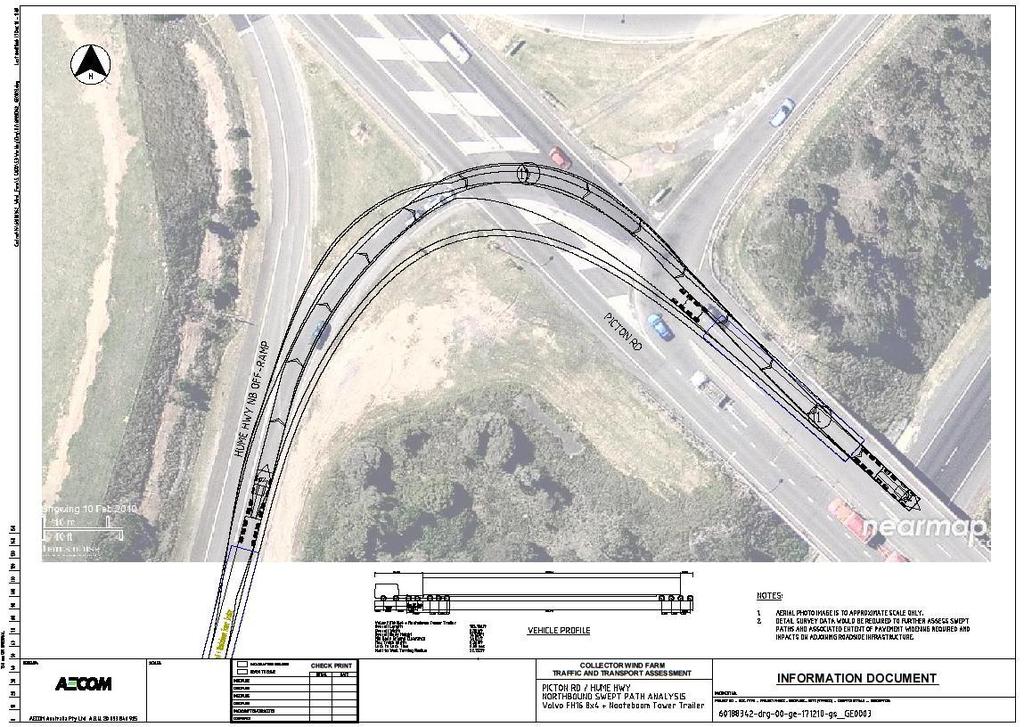
18 13 Construction Employees With regard to employee traffic generated, the number of workers at the site is expected to peak at 120 employees. Construction workers are likely to either be local or external employees housed predominately in Goulburn and will commute daily to the site. Some may be from or seek accommodation in Collector or Gunning, and there are likely to be some minor traffic impacts in Collector and Gunning from workers travelling to these towns to use shops, pubs, facilities, etc. Should a large number of workers be travelling from Goulburn, it is recommended that shuttle buses should be used to transport the workers to and from the site. However, for a worst case scenario, it has been assumed that the workers would travel by private vehicles. Based on the commute to work statistics from the Household Travel Survey (2010 release) 1, a vehicle occupancy rate of 1.1 people per vehicle is appropriate. This would therefore generate 110 vehicles to and from the site. Therefore, a daily total of 166 vehicles (56 concrete mixer trucks staff vehicles) would be generated during the peak daily construction phase of the wind farm Traffic Distribution Trucks bringing materials to the site would most likely come from sites originating to the east of the site large turbine parts would most likely be shipped to Port Kembla and trucked to the site, while concrete mixer trucks would be coming from the Goulburn area. With employee traffic coming from Goulburn and surrounds, all traffic accessing the site would travel along the Hume Highway and turn left into the site at Lerida Road South. Exiting traffic would return back along the same route Impact of Generated Traffic The impact of the vehicles has been assessed along the proposed truck route: - Lerida Road South - Hume Highway - Picton Road - Mount Ousley Road / Southern Freeway The entire route consists of four-lane, two-way roads on most of the sections except for the 27km long Picton Road section from the Hume Highway to Mount Ousley Road / Southern Freeway, which is a two-lane, two-way road with frequent overtaking lanes in either directions. Hume Highway The truck and vehicle traffic generated by the construction of the will result in an increase in the average daily traffic volumes on the surrounding road network over the construction period. The combined generated daily traffic movement of 332 vehicle movements is approximately 4.4% of the total daily volume on Hume Highway, which averages around 7,500 vehicle movements per day. Therefore, the Hume Highway will be able to absorb the increase in traffic during the construction phase without any significant impact on operation. There are two lanes in each direction on the Hume Highway at the Hume Highway/Lerida Road South intersection, with sufficient space to manoeuvre for normal goods vehicles. However, the intersection would not be able to accommodate the turning movement of the oversize trucks carrying the wind turbines. The Lerida Road South entry and exit should have traffic control in place for the safety of the traffic as the marked speed on the Hume Highway is 110 km per hour. Adequate signage should be displayed to inform motorists of the approach to the intersection for construction traffic turning. This should all form part of a Traffic Control Plan for the construction phase of works. This is governed by Australian Standard AS Picton Road The route for transporting the large turbines and materials from Port Kembla on OD vehicles is proposed via Picton Road. This is expected to generate 544 trucks (those carrying the tower sections, turbines, blades and 1 Transport Data Centre, 2008/2009 Household Travel Survey Summary report, 2010 release.
19 14 hubs/cables/controllers) over the course of the construction stage approximately one vehicle per day. However, it is noted that only one over dimensioned (OD) truck is planned to arrive at site at one time. Therefore, the trucks are not expected to have a significant impact on operations along Picton Road. The OD vehicles would be accompanied by pilot vehicles and scheduled to impact the least amount of vehicles as possible. Mount Ousley Road / Southern Freeway Similarly to Picton Road, the truck traffic from the Port is only expected to generate approximately one vehicle per day. Therefore, the trucks are not expected to have a significant impact on operations along Mount Ousley Road. The OD vehicles would be accompanied by pilot vehicles and scheduled to impact the least amount of vehicles as possible. Until shipping details are finalised, the exact point of truck origin cannot be determined, so the connection of Port Kembla with the Southern Freeway and Mount Ousley Road cannot be dealt with in detail. However, a number of B-double approved routes connect the Port with the strategic road network, so the impact of project-generated traffic in this area is considered minimal. It is noted that the construction traffic will be of a temporary nature. Swept paths of recognised wind turbine component transporter vehicles (the Volvo FH16 8x4 + Broshuis Blade Trailer and the Volvo FH16 8x4 + Nooteboom Tower Trailer) have been reviewed and the larger vehicle was tested at two key points along the truck route, namely the intersection of the Hume Highway with Picton Road and the intersection of Mount Ousley Road with Picton Road. These are shown in Appendix B. Based on this indicative analysis, some pavement widening and possible temporary relocation of roadside infrastructure would be required at the Mount Ousley Road intersection with Picton Road, and at the Hume Highway off-ramp joining Picton Road. While it is noted that on the return trip to Port Kembla, the transporter vehicle s trailer would be retracted, it has been tested at full length as a worst case scenario. Once more detail is known around the exact vehicles and routing, then more detailed swept path analysis should be undertaken along the truck route. Lerida Road South (and Crown Roads) A relatively significant increase of traffic volume on Lerida Road South could increase the risk of accidents with vehicles and stock. Therefore, lower speed limits should be enforced on the roads at all times during construction. To identify any upgrades to Lerida Road South and the Crown roads, AUSTROADS Standards has been reviewed. Table 3 presents the Austroads unsealed road classifications. Table 3 Austroads Unsealed Road Classification Class U1 Daily traffic (typical veh/day) >200 and/or >20% heavy vehicles* Description - All-weather formed pavement with adequate drainage provided. At least two pavement layers over subgrade. - Granular or modified materials may be adopted in the base and wearing course. Dust suppressants may be incorporated in maintenance strategies. Material quality and typical configuration - Crushed quarry materials or in situ processed natural gravels mm max size** wearing course, min. 100 mm thick mm max size base, min 150 mm thick mm max size subbase, min 150 mm thick. U and/or >10% heavy vehicles* - Mostly all-weather formed pavement with some drainage. Two pavement layers over subgrade. - Granular or modified materials may be adopted in the wearing course. Dust suppressants may be incorporated in maintenance strategies. - Crushed quarry materials, crushed pit material, on road processed natural gravels mm max size wearing course, min 100 mm thick mm max size base, min 150 mm thick.
20 15 Class U3 Daily traffic (typical veh/day) and/or <10% heavy vehicles* U4 <20 U5 <10 Description - Formed pavement with surface drainage. Max of two pavement layers over subgrade. - Granular or modified materials may be adopted in the wearing course. Dust suppressants may be incorporated in maintenance strategies. - Unformed pavement with single pavement layer over subgrade. - Unformed pavement comprising subgrade only. Material quality and typical configuration - Natural gravels, pit materials or quarry wastes mm max size wearing course, min 100 mm thick mm max size subbase, min 150 mm thick. - Natural gravels, pit materials or quarry waste mm max size wearing course, min 150 mm thick. - Vegetation cleared subgrade. In some circumstances, a wearing course may be incorporated as a thin binding course over subgrade (armouring to improve trafficability) *heavy vehicles are defined as Class 4 vehicles and above or mine haul trucks **refers to maximum stone size No traffic counts are available for the Lerida Road South site access. However, as it is mainly an access route for the farms in the area, a small amount of existing traffic is present. The temporary construction traffic generated from the site vehicles is expected to be the vast majority. The expected AADT of 332 movements (166 daily vehicles x 2) is presented in Table 4. Based on the Austroad guidelines presented in Table 3, the following upgrades would be required: Table 4 Proposed Upgrades to Access Road Road Existing Daily Traffic (veh/day) Lerida Road South 0 Likely Future Daily Traffic (veh/day) 332 (34% heavy vehicles) Extent of upgrade required Upgrade to unsealed road class U1 For the construction phase, access roads/tracks would need to be up to 8m wide to allow access for larger equipment (e.g. mobile cranes) Site Road Upgrades Traffic Generation Based on the turbine construction traffic calculated, upgrading to Lerida Road South and the Crown roads would be required. New internal access roads to the individual turbine sites are also required to be constructed. The gravel requirements for upgrading and building of the road are expected to be: - 40,000 m 3 of gravel to be transported to the site over six months during the pre-construction phase for upgrading of Lerida Road and the Crown roads; and - 60,000 m 3 of gravel to be transported to the site over the first 12 months of the construction phase for construction of the internal roads. It is proposed that the road upgrades are staged so as to avoid compressing delivery periods and to avoid overlapping peak deliveries for concrete pours. The construction vehicles to the site are outlined in Table 5. These estimates are based on a weight of 2 tonnes/m 3 of gravel and an average load of 20 tonnes of gravel for a truck and trailer combination ( truck & dog ).
21 16 Table 5 Construction vehicles visiting the site No. of Construction Trucks Material Pre-construction Construction Road gravel 4,000 6,000 During the six months of the pre-construction stage, assuming approximately 300 working days per year, there would be 27 trucks accessing the site per day. This would equate to 54 truck movements per day. During the 12 months of the construction stage, approximately 20 trucks per day would be generated, equating to 40 truck movements. Traffic Distribution Material will be sourced from local quarries located in the Goulburn area or closer to site, and will be transported along the Hume Highway to enter the site at the Lerida Road South intersection. Impact of Generated Traffic The trucks generated in the pre-construction phase are roughly half that of the continuous concrete pour scenario described in Section 5.1.1, and hence any impacts would be less. With the staging of the two different activities (road and WTG construction), the cumulative effects of the two activities during the construction stage would be 31 trucks (20 road trucks and 11 WTG trucks) per day and 110 daily staff vehicles, i.e. a total of 141 vehicles per day during the peak construction phase of the wind farm. This is slightly less than the 166 vehicles generated in the continuous concrete pour scenario described in Section 5.1.1, with similar impacts, i.e. no significant impact on operation along the external road network. 5.2 Operational Phase The operational phase of the is not expected to generate significant volumes of traffic with approximately seven maintenance trips expected per week. These would normally comprise only service vehicles carrying personnel undertaking general maintenance on the site. This would have a minor impact on Lerida Road South, insignificant impact on the Hume Highway and would not impact Picton Road or Mount Ousley Road, unless the maintenance required parts from Port Kembla. In this case, the impact would still be minimal based on the low numbers of vehicles generated. The number of permanent staff on site is not expected to exceed 25 people; which in a worst case scenario would generate 25 vehicles per day. There may be some minor impact on traffic in Collector and Gunning from employees looking to access local shops, pubs, services, etc. The combination of the 25 staff trips and one daily maintenance trip is considered to be a minimal generation with minimal impact on the road network and therefore no further measures would be required to manage this traffic. The operational phase access requires roads/tracks to be up to 6m wide.
 load permits will be required for the transportation of: - Tower sections, - Blades, - Turbines, and - Large")
 contained in NSW RMS")

22 Restrictions and Approvals 6.1 Over Dimensioned Vehicle Permits Over Dimensioned (OD) load permits will be required for the transportation of: - Tower sections, - Blades, - Turbines, and - Large cranes used for the erection of these components. The loads will require pilot vehicles and it is mandatory to contact the police. The number of pilot vehicles is dependent upon the load length or width as outlined in the Pilot Vehicle Graphs (Figure 7, Figure 8 and Figure 9) contained in NSW RMS Publication Operating Conditions: Specific permits for oversize and overmass vehicles and loads. The hours of movement are also contained within the publication and are summarised in Table 6, however, as per the publication, any restrictions may be increased if police consider it necessary to ensure safety. Figure 7 Daytime pilot requirements for load-carrying and special-purpose vehicles Figure 8 Night travel pilot requirements for special-purpose vehicles Figure 9 Night travel pilot requirements for load-carrying vehicles
23 18 Table 6 Weekend and state-wide public holiday restrictions for all vehicles Road or Area Hume Highway Width limit Over 3.5m Length limit Over 12.5m (vehicle) or 25m (combination) Start Point F5 South Western Freeway interchange at Casula End Point Sutton Forest Restrictions and Comments You must not travel in the daytime after 8.30am Position of Pilot Vehicles When one pilot vehicle accompanies an oversize vehicle, the pilot vehicle must travel: - Behind an oversize vehicle when travelling on a divided road; or - In front of an oversize vehicle when travelling on a road that is not divided. When two pilot vehicles accompany an oversize vehicle, one pilot must travel in front of the vehicle and the other must travel behind Contacting Police If a vehicle operator is required to contact police before travel under the conditions of either a General Class 1 Oversize Notice or a specific permit, the operator must contact the NSW Police Regional Traffic Coordinator closest to the starting point of the journey. Police may require up to seven days notice before travel to ensure police escorts can be allocated if needed. This is independent of the requirement to contact police before travelling through a critical location. 6.2 General Operating Requirements Load Limits A specific permit is issued to a load-carrying vehicle subject to compliance with the load limits specified in Schedule 2 of the Road Transport (Mass, Loading and Access) Regulation Operators may apply for a combined oversize and overmass permit High Loads Indivisible items that are higher than 4.6 metres when loaded must only be carried on the lower deck of a stepdeck trailer or low loader Rear-end Steering If a combination (including any load) is longer than 30 metres and travelling through a metropolitan area, or longer than 35 metres and travelling outside a metropolitan area, the RMS can require that the vehicle uses rear-end steering. 6.3 Rehabilitation of Public Roads used as Access Roads The condition of the public roads/crown roads to be used for the delivery of raw and fabricated materials should be established prior to commencement of works and then regularly monitored during the period of the works. The road and intersection conditions should be established by the use of field surveys and regular site inspections. When required, rehabilitation of the pavement and/or edges of seal, shoulders and verges will be carried out. At the completion of the works the access roads should be in the same or superior condition than at the commencement of the works.
24 Conclusions and Recommendations 7.1 Conclusions This assessment of the proposed has concluded that the impact on the strategic road network of the traffic generated is likely to be minimal, and will mainly be during the construction stage. The project is likely to generate a maximum traffic demand of approximately 110 staff vehicles and 30 trucks per day during the construction stage (for both road upgrade and WTG construction), with a worst case scenario of 56 trucks per day during concrete pouring periods. The impact of the construction traffic generated by the site along the truck route in terms of capacity is likely to be minimal, aside from the local access road (Lerida Road South), which will have a relatively large impact due to the low existing traffic on the road. Lerida Road South will require to be upgraded (to unsealed road class U1) to accommodate the construction vehicles. The impact of the additional traffic on the Lerida Road South/Hume Highway intersection level of service is expected to be minimal; however, there will be safety impacts due to the large construction vehicles turning across the Hume Highway at the intersection, therefore construction traffic control is required at the Lerida Road South entry and exit. Oversize vehicles used to transport materials to site will require an OD permit from the RMS and the police should be contacted for movement of the oversize vehicles. Based on indicative swept path analysis, some pavement widening and possible temporary relocation of roadside infrastructure may be required at the Lerida Road South/Hume Highway intersection, at the Mount Ousley Road intersection with Picton Road, and at the Hume Highway off-ramp joining Picton Road. 7.2 Mitigation and Management Measures The following mitigation and management measures are proposed to reduce the impact of the development on the local road network: - For safety reasons, the Lerida Road South entry and exit should have traffic control in place. Adequate signage should be displayed to inform motorists of the approach to the intersection for construction traffic turning. This should all form part of a Traffic Control Plan (governed by Australian Standard AS ) for the construction phase of works, which will also cover the upgrade of the Crown roads and the Lerida Road south intersection upgrade to accommodate the oversize vehicles; - Large oversize materials should be transported outside of peak traffic times to reduce impacts on road network (subject to RMS approval); - Once more detail is known around the exact vehicles and routing, then more detailed swept path analysis should be undertaken along the truck route; - Cattle bridges on Lerida Road South and farm roads / Crown roads will need to be removed during construction. The internal roads in the site are required to be widened to 8m in order to transport the construction materials and the large turbines to the desired location, and will require surfacing upgrade through grading. This will need to be co-ordinated with the landowners and farmers; and - The road and intersection conditions should be established by the use of field surveys and regular site inspections. When required, rehabilitation of the pavement and/or edges of seal, shoulders and verges should be carried out. At the completion of the works the access roads should be in the same or superior condition than at the commencement of the works.
25 Appendix A Accident History

26 a-1 Appendix A Accident History Accident locations on section of Hume Highway from Goulburn to Gunning in the north of the site

27 a-2 Crash Summary Report from the RMS
28 B Appendix B Vehicle Swept Paths

29 b-1 Appendix B Vehicle Swept Paths

30 b-2
31 b-3