Clustering the Motorways of the Sea, Århus, 12 April 2011
|
|
|
- Rosamond Fields
- 5 years ago
- Views:
Transcription


1 Clustering the Motorways of the Sea, Århus, 12 April 2011

2 MONALISA develops Motorways of the Sea, contains eco efficient e navigation solutions and supports the EU Strategy for the Baltic Sea Region

3 MONALISA Some Basic Facts Budget: 22.4 M EU grant from TEN T: 11.2 M Implementation period: Sept Dec Lead Partner: Swedish Maritime Administration
4 Background of the Project Strong cooperation in the Baltic for development of Motorways of the Sea Focus on environmental aspects of maritime transport Green Corridors EU Strategy for the Baltic Sea Region HELCOM Moscow Minsterial Declaration A Swedish initiative gained support Consortium established with partners from public authorities, private sector and academic organisations
5 Scope of the MONALISA project
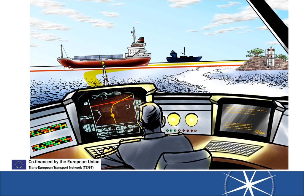
6 Dynamic & Proactive Routeplanning! Everybody sees where everybody s going!! Green routes with reduced costs and emissions All ships will have it s unique designed route Monitoring, guidance and assistance All routes monitored from control centers Anti collision aid Ship to Ship exchanging of routes Improved Surveillance Less ships to focus on will increase quality


7


8 Finland Traffic Sweden Traffic Routes transmission Poland Traffic Processed info from shore
9
10 Ship on my port side what s your intention???? Regular radar picture?
11 Routes on NAV Monitor Bouy 1 Bouy 3 Bouy 2 Lighthouse Bouy 4 Bouy 7 Bouy 6 Bouy 8 Bouy 5

12 Dynamic & Proactive Routeplanning Improved: environment, safety and security Optimal way calculating with weather, current, ETA, pilots Reduced fuel consumption Time optimized ETA Reduced Carbon footprint Reduced costs Surveilling authorities can focus on risk vessels
13 Automatic Verification System Question: How to be sure of officers: Valid certificates for: Actual vessel Position Pilot exemption Actual time on watch Port State Control LL certificates etc

14 Automatic Verification System A new international ID smartcard (ICC) will be issued to all watchkeeping officers and masters containing data of: Nautical and engineers certificates Cargo related certificates Radio certificates Pilot exemptions certificates Etc. ICC card to be inserted in a card reader connected to the AIS equipment onboard during all on watch period


15 Automatic Verification System Certificates automatically matched with requirements for: Actual ship Present position in sailing waters (open sea or pilot area) Actual time on watch (verifying workhours regulations) In case of discrepances with any regulation, the ship will be flagged accordingly on MOS centers monitors


16 Ensuring the Quality of Hydrographic Data on Shipping Routes and Areas Re survey of HELCOM fairways and Baltic Sea port areas with modern standards; EU Baltic Sea Strategy Action Plan HELCOM Moscow ministerial declarations in May 2010 Safety of Shipping in the Baltic Sea; e Navigation, Route planning, ENC data, Depth Model Russian participation to sub activities 3.2 and 3.3 is encouraged.
17 Activity 3 Background Project will implement EU Baltic Sea strategy, directly priority area 13 To become a leading region in maritime safety and security Flagship Project 13.3 Speed up re surveys on major shipping routes and areas. In addition project will support goals in Baltic Sea strategy priority areas 4 To become a model region for clean shipping, 6 Internal market (single window), 11 To improve internal and external transport links and 14 To reinforce protection from major emergencies at sea and on land. Activity 3 will also give examples of HELCOM Moscow Declaration effects on navigation information in practise


18 Data uniformity is necessary for seamless route planning and data exchange, as well as for depth model. Therefore acquisition of digital geographic information data is the first step HELCOM AIS vessel track history

![areas for numerical data Finland about 14.000 km², budgeted ~8 M [red areas] Sweden about 17.](/docs-images/89/100801786/images/19-1.jpg "000 km², budgeted ~7,5 M [green areas] Time span 2011 2013 2011 one year contract for Bothnian Sea area,")
19 Sub activity 3.1: Speed up re surveys Finland leading, Sweden participating Re surveys of HELCOM I and II routes and areas for numerical data Finland about km², budgeted ~8 M [red areas] Sweden about km², budgeted ~7,5 M [green areas] Time span one year contract for Bothnian Sea area, contracted to Fugro OSAE GmbH one or two year contract on remaining areas TED planned in June 2011

20 Sub activity 3.1: Bothnian Sea Survey 2011 EU restricted procurement process Invitation to participate, published on 4 Oct 2010 Applications to participate by 12 Nov 2010, update of information by 8 Dec > 8 participants; Pre selection: 3 fulfilled the requirements > invitation to tender sent on 8 Feb 2011 and tender due date 21 Mar Two tenders and one announcement; Lump sum 3,1 M > Fugro OSAE to perform ~ km² About equal survey time for Finland and Sweden, freedom of work for the Contractor: 2 vessels; Deliveries due 30 Nov 2011 > validation > navigation information study and data model [2012]

21 Sub activity 3.1: Bothnian Sea Survey 2011 Quoted areas Finnish areas ~8.488 km² ~109,9 ship days Swedish areas ~4.845 km² ~124,6 ship days


22 Sub activity 3.2 Development of Baltic Sea Depth Model In co operation with the BSHC Working Group Sweden leading, Finland participating, Estonia, Germany and Poland observing To develop a system for exchange of high density depth data To develop depth models, harmonized data sets, virtual database To test the data model in small scale To visit Baltic Sea HOs for problem solving Meetings start on April 2011

23 Sub activity 3.3 Pilot implementation of harmonized vertical In co operation with the BSHC reference Working Group Finland leading, Sweden participating, Germany observing To develop a small scale pilot implementation of a harmonized vertical reference and to study and analyze the implications of implementation To develop examples and recommendations to BSHC members for their transition to a harmonized vertical reference First meeting on 2 Nov 2010 at Hydro 2010
24 Activity 3 will also Set practices to harmonize hydrographic surveys in Finnish and Swedish EEZ Set practices to harmonize distribution of survey data and water level information within the Baltic Sea Enhance navigation infrastructure and nautical products and study the changes in navigation information due to the performed re surveys Support e Navigation in implementation of Activity 1 Support safety to maintain position in Paris MOU concerning collisions and groundings

25 Thanks for your attention Magnus Sundström, Swedish Maritime Administration Ulf Svedberg, Swedish Maritime Administration Taneli Antikainen, Finnish Transport Agency