AASHTO. Automated Cross-Slope and Drainage Path Method
|
|
|
- Ashley Armstrong
- 5 years ago
- Views:
Transcription

1 Automated Cross-Slope and Drainage Path Method
2 Presentation Outline: Contributing factors to Hydroplaning Traditional and Automated Survey Methods Multi-Purpose Survey Vehicle (MPSV) and Subsystems Automated Cross-Slope Analysis Program (ACAP) Field Validation Examples Conclusion
3 Factors that contribute to hydroplaning: Driver Vehicle Environment Pavement Surface (geometry, condition, drainage)
4 Pavement Cross-slope Facilitates/hampers drainage Grade Affects drainage path (DP) Rutting Increases water retention

5 Traditional Survey Methods Slow and labor intensive Expose crew to hazardous conditions Require traffic control Cause inconvenience to traveling public Costly
6 Automated Survey Methods Fast (highway speed) Safe (no traffic control required) Efficient (simultaneous data collection) Cost-Effective
7 Automated Cross-Slope and Drainage Path Method Multi-Purpose Survey Vehicle (MPSV) to collect pavement data, and Automated Cross-Slope Analysis Program (ACAP) to analyze data
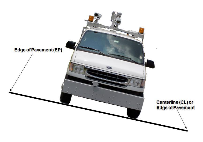
8 Multi-Purpose Survey Vehicle (MPSV) Inertial Profiling System Position and Orientation System (POS)
9 Multi-Purpose Survey Vehicle (MPSV) Inertial Profiling System Position and Orientation System (POS)
 Automatic")
10 Inertial Profiling System Three height laser sensors Two accelerometers Distance Measurement Indicator (DMI) Automatic Trigger System

11 Multi-Purpose Survey Vehicle (MPSV) Inertial Profiling System Position and Orientation System (POS)
 Inertial Measurement Unit (IMU) Distance Measurement Indicator (DMI) POS")
12 Position and Orientation System (POS) Differential Global Positioning System (DGPS) Inertial Measurement Unit (IMU) Distance Measurement Indicator (DMI) POS Computer
13 Differential Global Position System (DGPS) Roof antennas Receiver (12 channel) Differential correction signal

14 Inertial Measurement Unit (IMU) Generates tilt, roll and yaw data 3 accelerometers 3 gyroscopes
 Linear distance")
15 Distance Measuring Indicator (DMI) Linear distance referencing

16 POS Computer Data storage and processing POS Computer
17 Input Data from MPSV Cross-Slope Grade Rutting Linear Reference (Distance)
18 Automated Cross-Slope Analysis Program (ACAP) Imports MPSV data (cross-slope, grade, rutting, distance) Calculates drainage path length Generates outputs (tabular and graphical)

19 Automated Cross-Slope Analysis Program (ACAP)

![)[1+(S G /S C ) 2 ] (1) W C](/docs-images/90/101403611/images/20-2.jpg "= pavement width (ft) S G =")
 (1) John")

20 Drainage Path Length Calculation DP 2 = (W C2 )[1+(S G /S C ) 2 ] (1) W C = pavement width (ft) S G = grade (ft/ft) S C = cross-slope (ft/ft) (1) John C. Glennon: Hydroplaning The Trouble With Highway Cross-Slope (January 2003)
 Text")
21 Automated Cross-Slope Analysis Program (ACAP) Text Report
22 Automated Cross-Slope Analysis Program (ACAP) Tabular Output
23 Automated Cross-Slope Analysis Program (ACAP) 2D Graphical Output
 3D Graphical Output (work in")
24 Automated Cross-Slope Analysis Program (ACAP) 3D Graphical Output (work in progress)
25 Field Validation
26 MPSV Cross-Slope Precision Repeatability: 0.06% Accuracy: ± 0.13 %
27 Case Example 1 Problem: Shallow cross-slope within super elevation of interstate Consequence: Vehicle departures reported


28 Before Notice This Zero Value After

29 Case Example 2 Problem: Poor pavement drainage reported on 6-lane rural interstate Consequence: Roadway departures reported

30 Before Corrective Action

31 Short-Term Preventive Action
32 Short-Term Preventive Action
33 Short-Term Solution

34 Long-term Solution Milling Overbuild
35 Observations Substantial cross-slope improvement Smoother transition in and out of super-elevation Elimination of surface drainage problem No new roadway departures reported
36 Automated Cross-Slope and Drainage Path Method Identifies areas of pavement prone to hydroplaning For design, construction and safety projects Assists in developing short and long term solutions Safe, fast and very effective
37 Thank You!