Drone Basics 101 Technology, Regulations and Project Examples. Tom Gehrdes & Alton Whittle
|
|
|
- Mary Booker
- 5 years ago
- Views:
Transcription

1 Drone Basics 101 Technology, Regulations and Project Examples Tom Gehrdes & Alton Whittle
2 What are UAVs? Unmanned Aerial Vehicles (UAVs) are remotely operated aircraft that fly without the possibility of human intervention or control from within the aircraft. Commonly referred to as drones UAVs are one component of an Unmanned Aircraft System (UAS), which is how the FAA describes the various components necessary to operate a UAV. The UAS has multiple parts: UAV, payload, control link, operator, visual observer, etc. Most UAVs are considered small UAS (suas) (greater than 0.55 lbs and less than 55 lbs) The FAA regulates UAS: Hobbyist: Section 336 Fly under the Special Rule for Model Aircraft Commercial Use: Part 107 Fly under the FAA's Small UAS Rule Difference between hobby and commercial use is application, not aircraft and different rules apply
3 UAS Technology


4 Types of UAVs Some common types of UAVs in operation and benefits include: Quadcopter Low cost Highly portable with rapid deployment Interchangeable sensors and cameras Hexacopter Similar operational benefits to quadcopter with higher cost Heavier payloads More redundancy Fixed-wing Greatest range, endurance, and speed Increased cost May require launch and recovery system Image placeholder Image placeholder Image placeholder


5 Payloads for UASs Some common types of payloads used as a part of the UASs include: Cameras RGB IR Multispectral LiDAR Light detection and ranging Works on the principle of radar, but uses light from a laser Sensors sniffers Chemical/Gas Biological Acoustical Image placeholder Image placeholder Image placeholder


 High-resolution surface imagery 2 to 5 CM level accuracy with 50")
6 Examples of Imagery Red, green, blue (RGB) Normal video and photo for visual observation, documentation With semi-autonomous flight, can be post-processed for surveying, incl. 3D models Infrared (IR) Calibrated cameras can quantify temperatures and identify points of interest Multispectral Multiple sensors capture different EM spectrums Used with image processing to identify materials, stressed vegetation (NVDI), etc. Light Detection and Ranging (LIDAR) High-resolution surface imagery 2 to 5 CM level accuracy with 50 points taken every square meter as opposed to 3 to 5 points taken every 25 feet using traditional survey


7 UAS Selection Selection of the aircraft and other components based on mission needs: Type of imagery/sensor (payload) Project application and implementation Mission Area Endurance, speed Operating site conditions take off/landing area, water operations, weather Downlink Live feed and broadcasting, second operator, reliability, security Image placeholder Image placeholder Image placeholder Image placeholder
8 Applications Emergency Response Resource Management Environmental Management - Situational Awareness - Locate Spills and Receptors - Determine Leading Edge - Calculate Downstream Speed - Chemical Detection and Air Quality - Document Response and Cleanup - Disaster Assessments - Asset Inspections - Permitting & Planning - Progress Documentation - Slope Failure Analysis - Urban Planning - Surveying - Agriculture - Insurance Documentation - Vegetation Health Assessments - Environmental Impact Studies - Site documentation - Research - Wildlife Management Maximizing the potential of UAVs as a tool will rely on input from users and discussing where UAVs can assist with operations: Consider what information would improve your job function? Consider what tasks could be more efficient and safer using drones?


9 UAV Aerial Imaging Existing uses Emergency Response: Provide live feed aerial video of an incident site, pre-entry aerial inspection of area, & visual coverage of responders Rapid and frequent collection of still images of an incident scene as well as the documentation of site conditions on regular intervals. Remediation: Aerial images can be used as foundation for figures showing impacted areas and boundaries of remediation activities Images can be taken from same location each day/week/month to show a time lapse view of progress Inspections: Photo and video inspections of hard to reach areas Examples: Overflight of large sites utilizing GPS guided grid Phase I Environmental Site Assessments Oil field detection Fence line/pipeline inspections Real-time video of an emergency response site
10 Benefits 1. Quick deployment & high portability including Vertical Take Off/Landing (VTOL) for many models 2. Ability to fly in areas inaccessible to manned aircraft 3. Reduced risk to personnel 4. High resolution imagery 5. Low profile and low impact 6. Rapid turn around time 7. GPS hover a tripod in the sky 8. Valuable data (i.e. logistics and evidence) Fundamentally, the benefits allow UAVs to be a useful tool for collecting information
11 UAS Regulations
12 Current Regulatory Framework FAA regulates the use of UAS in the national airspace Some localities instituting patchwork legislation and ordinances Commercial operations allowed via two mechanisms by FAA: Section 333 Exemption using blanket or specific Certificate of Waiver or Authorization (COA) suas Rule (Part 107) Public agencies can apply for COA without obtaining Section 333 Exemption or choose to operate under Part 107 Technology is progressing rapidly and regulations are evolving to balance safety, industry development, and stakeholder concerns. Part 107 limitations reflect integration concerns.
13 Section 333 Exemption Section 333 of the FAA Modernization and Reform Act of 2012 (FMRA) grants the Secretary of Transportation the authority to determine whether an airworthiness certificate is required for a UAS to operate safely in the National Airspace System (NAS). This authority is being leveraged to grant case-by-case authorization for certain unmanned aircraft to perform commercial operations prior to the finalization of the Small UAS Rule, which will be the primary method for authorizing small UAS operations once it is complete. Cumbersome - licensed commercial pilot needed to be on staff and present for the operation, surface to air radios required, etc Superseded by Part 107 which went into effect on August 29, 2016 Existing Section 333 exemptions are still honored but cannot be renewed and can not be mixed or matched with Part 107 rules and regulations
14 Part 107 Key Requirements Requires FAA knowledge test and background check for Remote Pilot Certificate Remote Pilot acts as Pilot in Command Maintain unaided visual line-of-site (VLOS) with aircraft No operations over non-participants Daylight only, civil twilight with anti-collision lighting Maximum altitude of 400 AGL (unless within 400 of structure) Minimum visibility of 3 miles Operations in controlled airspace (B, C, D, E) requires ATC approval currently requires notification 90 days in advance (ER introduces separate consideration) No operations from moving vehicle except in sparsely populated areas No transport or carrying hazardous materials Note requirements of Part 107 can be waived with approved application to FAA
15 New 2018 FAA Reauthorization Act Authorizes the FAA to establish a remote identification solution to monitor airborne drones Creates a framework for authorities to take emergency action against drones that appear to pose threats Emphasizes safety education for drone pilots, including requiring tests to help ensure they understand the rules of safe flight Encourages drone manufacturers to innovate new technological approaches to improving safety and to place them on the market as soon as possible
16 License for UAS To fly under the FAA's Small UAS Rule (14 CFR part 107), you must: Get a Remote Pilot Certificate from the FAA Register your UAS as a "non-modeler" Follow all part 107 rules Remote Pilot Certification Be at least 16 years old Pass an aeronautical knowledge test at an FAA-approved knowledge testing center Undergo Transportation Safety Administration (TSA) security screening
17 Document Links and Resources
18 UAS Project Example


19 ADA Ramp As-Builts - Borough of Everett Area Municipal Authority As-built horizontal and vertical data for ADA ramps as part of sanitary sewer improvements project. Utilized photogrammetry point cloud triangulated from the UAV s GPS coordinates applied to each photo. Data previously captured by traditional survey methods Significant time savings - GHD Pilots were able to go out within a week and collect data Anticipated cost savings don t have comparative figures for this project due to small scope. Vertical accuracy is a key restricting factor for drone selection recommend unit outfitted with 1.5 cm vertical GPS accuracy and sufficient control points for tie-in to existing drawings


20 Water Main Replacement - Aqua Thornhust Surveying with photogrammetry point cloud for replacement of 10,500 linear feet of water main Previously required purchasing or using available aerials & strip survey performed by surveyor Provided higher quality imagery Saved effort in picking up existing utilities


21 Pre-Construction Aerial Survey Prior to the redevelopment of a ~20 acre lot, GHD performed a UAV survey of the area using a semi-autonomous flight in a grid with photos Post-processing of the data combined the photos to create a single ortho-mosaic image with ground elevation data visually represented by contours, using a 1- ft contour interval A separate flight was used to collect high resolution video for documentation Flight plans were saved so they can be reproduced in the future if needed Area and volume calculations using the elevation model Marked and surveyed ground control points to increase accuracy


22 Air Monitoring Jacksonville, Florida Conducted UAV proof-of-concept testing to conduct air monitoring in plumes emanating from hazardous materials release. Mounted Equipment: Carbon Monoxide and Particulate Matter Detector Series of petroleum burn tests conducted at the Fire Academy of the South in Jacksonville, Florida UAVs indicated the presence of both particulate matter and carbon monoxide at levels consistent with measurements


23 Emergency Response Pipeline Spill GHD provided emergency response services onsite for large pipeline release (>100k gallons) Eliminated need for hazarding personnel in dense foliage and pond areas UAV was equipped to provide site reconnaissance and mapping using orthomosaics and air monitoring Spill Assessment - Quantifying volume of oil released, flow direction, and observe the extent of the spill Response Documentation - record the progression of site response, soil removal, and clean-up activities Inventory Tracking - UAV was used to track inventory of equipment and materials used


24 Emergency Response Pipeline Spill (cont.)

25 Emergency Response - Train Derailment GHD provided emergency response services onsite for train derailment UAV flights were used to document the progression of site response and clean-up In some instances, weather posed challenge due to low temps and snow At one site, UAV operations were able to observe progress and conditions without hazarding additional personnel with float operations in icy water


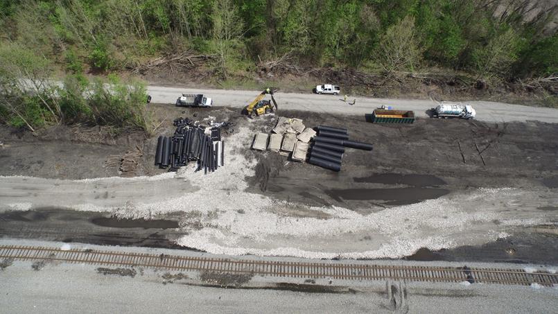
26 Emergency Response - Train Derailment (cont.)

 was determined to be the safest survey method due to the steep")
27 Hydrocarbon Contamination - Alaska Investigations associated with a mobile subsurface Hydrocarbon plume. Topographical map of the coastal zone to investigate areas of potential #erosion and deposition IR and RGB video of the inlet at high tide to identify any fugitive hydrocarbon sheens Updated RGB map of the facility The survey area (coastal zone) included a 50-foot cliff, beach area, and tidal flat Remote aircraft-mounted LiDAR (Light Detection and Ranging) was determined to be the safest survey method due to the steep topography and extensive tidal flat (mud)
28 Closing 1. UAS continues to evolve at rapid pace - regulatory environment continues to work on keeping up 2. In US, sales of commercial UAS projected from 600,000 in 2016 to 2.7 million by 2020 with large economic impact 3. Industry users need to monitor stakeholder concerns (privacy, safety, etc.) and encourage responsible use to avoid excessive pushback and limits 4. Understand limitations and benefits of UAS to use as additional tool and how to effectively integrate with existing operations 5. The time it takes to conduct a full survey of large sites has been drastically reduced while generating an even higher level of accuracy with the added benefit of having an updated aerial image.
29 Questions?
30