efarled Beslutningsstøttesystemer Ombord
|
|
|
- Katrina Jenkins
- 5 years ago
- Views:
Transcription
1 efarled Beslutningsstøttesystemer Ombord Foredrag på Maritim Innovasjon november 2007 DnV, Høvik Morten Zachrisen Utvikling, DP & Navigasjon Kongsberg Maritime 1

2 efarled Implementation on Onboard Systems: ECDIS, Radar, Planning Station 2
3 Next Generation ECDIS ECDIS = Electronic Chart Display and Information System Improved position integrity (from Kongsberg Seatex) Extended AIS support (from Norcontrol IT/Seatex) Using extended functionality in C-Map SDK 4 New VTS provided services (from Norcontrol IT) New Weather services (from met.no/cmr) Other services based on WMS (Web Map Services) New Search and Rescue Patterns New Navtex database support 3

4 efarled Kongsberg Seatex Goal: Establish a concept, methodology and prototype system for secure maritime position determination based on future satellite navigation infrastructure. 4
5 Extended AIS support Class B targets (small vessels) Weather buoy information Radar targets (from VTS) 5
6 Extended functionality from C-Map SDK4 Tide tables Tidal stream data Daylight information C-Routes automatic route generation Weather forecast data Weather data overlay Weather time series Weather overlaid on route plan Synchronization of databases and updates on bridge network Dynamic licensing 6

7 World-wide tide tables 7

8 Automatic construction of routes (C-Routes) 8


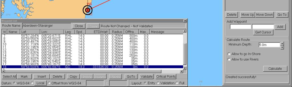
9 Route editing and validation 9

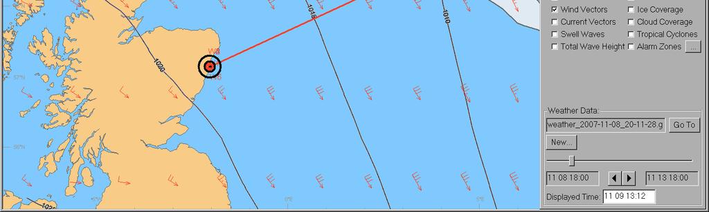
10 Weather prediction overlay on chart 10

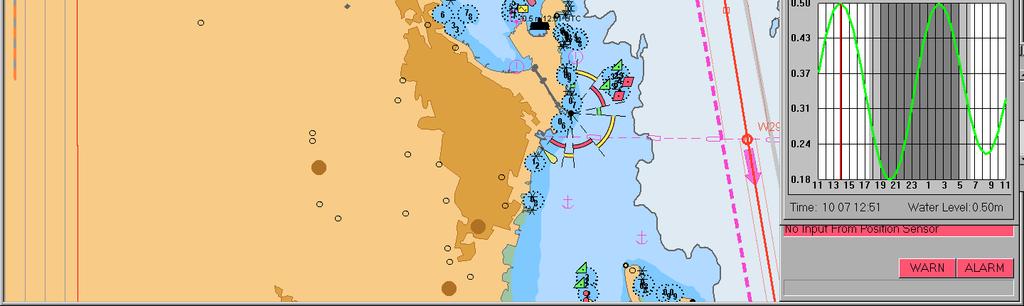
11 Weather time series at Aberdeen 11


12 Route simulation with weather alarm


13 Route simulation with weather alarm


14 Route simulation with weather alarm


15 Route simulation with weather alarm
16 WMS-based services ECDIS as WMS-Client: ECDIS/Planning overlay should be able to generate requests and display WMS pictures from WWW or local servers (sonars ) ECDIS as WMS-Server: ECDIS/Planning should be able to provide chart image (or site map ) to local clients (sonars, DP, passenger information system ) 16


17 WMS Weather Display - Pressure 17


18 WMS Weather Display - Wind 18


19 WMS Weather Display Object Information 19
20 Port VTM WMS Information services Information services Need for distribution of information from the port to arriving ships local weather condition in the port - wind - wave height - current depth at the berth (3 D visualization of the floor) berth plan approach route (proposed sailing-route ) non-ais targets, where the targets equipped with AIS transponder are removed from the snapshot status of lights and buoys in the fairway search & rescue areas temporary restricted areas 20
21 Port VTM WMS WMS/AIS Method(s) for distributing information to the ships The intention is to extract/convert port information to a WMS server at the VTS center for the ships to download. The information will be structured in layers such that the client (user) can ask the server for the information content, thereafter retrieve the specific information the client is looking for. Primarily this method has been used for distributing static information For dynamic information the Pseudo-AIS message will be used to send non- AIS tracks from shore to ships. 21
22 Port VTM WMS - Capabilities Port VTM WMS Address Oslo Harbour Port Weather Condition Port Facilities Port Approach Route Status on Light and Buoys Temporary AoIs VTS Radar video 22
23 Remaining challenges How to make the user interface intuitive and self explaining How to fully utilize the WMS technology as an onboard infrastructure 23

24 WORLD CLASS through people, technology and dedication 24