MEMORANDUM. Date: July 14, 2006 Project #: To: US 97 & US 20 Refinement Plan Steering Committee
|
|
|
- Dana Harrell
- 5 years ago
- Views:
Transcription
1 MEMORANDUM Date: July 14, 2006 Project #: 6389 To: US 97 & US 20 Refinement Plan Steering Committee From: Sonia Hennum, P.E., Andrew Cibor, E.I.T., & Julia Kuhn, P.E. Project: US 97 & US 20 Refinement Plan Subject: Refined Alternatives Evaluation This memorandum summarizes the refined evaluation of the three remaining concept alternatives for the US 97 & US 20 Refinement Plan. Included is a description and graphical representation of each concept, an evaluation of each concept based on a focused set of performance criteria, and a summary of the Project Management Team s (PMT) direction regarding the relative advantages and challenges of each concept. The purpose of this memorandum is to provide the Steering Committee with sufficient information on each concept s performance and implications so that the group can begin the decision process of moving towards a preferred alternative. A joint work session will be held with the Steering Committee and PMT on July 20, 2006 to review the information summarized here and provide the Steering Committee with an opportunity to analyze the evaluation results, ask questions of both agency staff and the consultant, and discuss the appropriate next steps for the project. RECENT PROJECT PROCESS During the months of April and May 2006, the Project Management Team (PMT) and Steering Committee reviewed the evaluation of five broad system concepts across nine different evaluation criteria categories. These initial evaluation performance measures included cost, environmental impacts, traffic safety, traffic operations, multi-modal transportation considerations, construction, community impacts, rail implications, and policy considerations. The results of this evaluation were summarized in a technical memorandum dated April 14, 2006 and were discussed in PMT and Steering Committee meetings held on April 20 and May 10, FILENAME: D:\kittelson\new\refined_alternatives_evaluation_SC_July 2006.mem.doc
2 July 14, 2006 Page 2 Based on the results of the evaluation and discussions at the meetings, the Steering Committee provided the following direction to the project team for next steps: Focus further analysis on System Concepts 1 (US 97 Reroute), 3 (Rail Alignment), and 5 (US 97 Frontage Roads). These concepts provided the strongest balance between good evaluation performance and overall initial public support. As documented in the April 15, 2006 memorandum, System Concepts 2 (Existing Alignments) and 4 (US 20 Reroute) did not perform favorably across the established evaluation criteria and also were not publicly supported as strongly overall. As such, it was determined that further evaluation or refinement of these concepts was not warranted. Focus further analysis on a refined subset of the initial evaluation criteria. Based on the primary information needed to advance the decision-making process towards the selection of a preferred alternative, refined analysis will focus on the following four key performance measures: o Cost (construction and right-of-way) o Community Impacts (property, parcels, and neighborhood character) o Phasing and Implementation Considerations o Traffic Operations The remainder of this memorandum outlines the further refinement of the advanced alternatives and their evaluation across the focused four performance measures described above. ADVANCED LONG-TERM SYSTEM CONCEPTS Based on initial evaluation of five broad system concepts across the spectrum of evaluation criteria, the project team and Steering Committee have narrowed the range of most-promising options down to three primary alternatives: System Concept 1 (US 97 Reroute), System Concept 3 (Rail Alignment), and System Concept 5 (US 97 Frontage Roads). Each of the alternatives represents a general solution concept for addressing the long-term needs of the system-wide transportation network. Within each concept, there are variations for individual design elements such as specific roadway alignment, access locations, or intersection and interchange form. The ultimate goal of the US 97 & US 20 Refinement Plan is to establish a preferred System Concept that outlines a future vision for the study area transportation system so that environmental and planning work can begin on evaluating the details of specific design elements. However, at this refined level of analysis, certain assumptions have been made related to the specific design elements of each concept so that performance measures, such as cost and community impacts, can be assessed. The design specifics chosen here represent the project team s best determination of details such as roadway alignment given existing data and they allow for a good comparative evaluation between the various options. The work completed here will feed into future planning efforts once a preferred alternative is selected and these design elements will be further refined as part of subsequently environmental and engineering work.
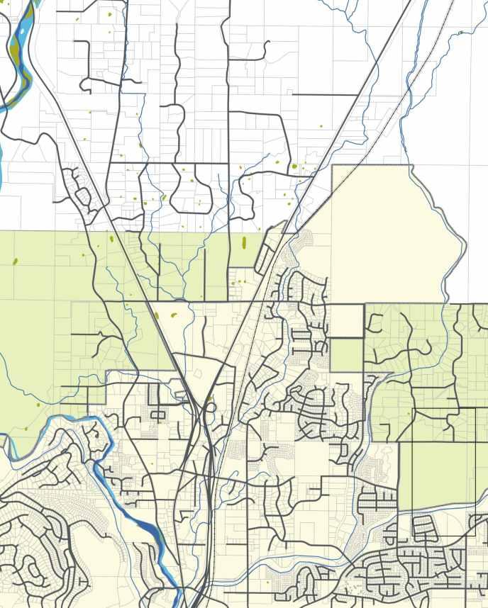
3 July 14, 2006 Page 3 The following sections describe the three advanced alternative concepts and present both conceptual and functional illustrations of each over aerial and tax lot mapping. Appendix A includes the detailed functional illustration maps for each remaining concept. The functional designs illustrate the roadway alignments used for each concept for the purposes of this evaluation analysis. While these represent the most likely general location of each concept based on project team work and public input, there are potential alternative alignments that could be developed still within the same overall theme and intention of the system concept. While representative alignments for each concept had to be assumed for the purpose of this analysis, once a preferred concept is selected, the specific alignment that it will take will be evaluated and determined through a subsequent environmental review process prior to project development. The refined functional layouts in Appendix A provide further detail of what each concept alternative could look like. These graphics provide a more complete illustration of how various connections and traffic flow would work under each alternative. Again, these graphics represent only one potential option for each concept and variations exist for individual design elements (such as detailed roadway cross-section specifics, access locations, or intersection and interchange form) within each overall solution. System Concept 1 US 97 Reroute Figure 1A conceptually illustrates System Concept 1, US 97 Reroute. The main feature of this alternative is to create an extension of the Bend Parkway (high mobility, access controlled facility) through the northern Bend Urban Growth Boundary (UGB) using the existing US 20 alignment and then continuing as a new alignment to connect back with the existing US 97 somewhere north of the existing UGB. Through and regional traffic would use this new Parkway extension, allowing the existing alignment of US 97 within the study area to function as a City arterial, serving local access and circulation to the adjacent businesses and neighborhoods. Initially, the main objectives of this concept were to: Separate long-distance, high-speed through traffic from local traffic and access needs Reduce adverse impacts of facility upgrade (wider right-of-way requirements, grade-separated interchanges) on properties adjacent to existing US 97 alignment Preserve traditional travel routes to and from commercial properties in the study area Maintain the potential for a US 20 connection/extension to the east of Bend Provide for a free-flow connection from US 20 to US 97 and the Parkway south of the triangle area Provide an interchange north of Cooley Road for access to the Juniper Ridge site (this will also provide a grade-separated crossing of the BNSF rail line)
4
5 July 14, 2006 Page 5 In previous analysis, the alignment for Concept 1 departed the existing US 97 alignment just north of the Veterans Memorial Cemetery and connected with US 20 at Cooley Road. As requested by the Steering Committee, a new alignment for Concept 1 has now also been analyzed. This new Southern alignment (illustrated in Appendix A in Figure A-1B) departs the existing US 97 just south of Veterans Memorial Cemetery, passes across Cooley Road, and then begins to parallel US 20 south of Cooley Road. The primary advantage of this alignment is that it brings the proposed roadway much closer to the existing UGB thereby minimizing the overall impact area of the new construction and its proximity to existing rural neighborhoods north of Cooley Road between US 97 and US 20. However, in order to accommodate this more southern alignment, from a functionality standpoint there are certain notable differences between this variation and the more northern version analyzed previously: Significant increase in difficulty to create access to the Juniper Ridge site from the northern new alignment tie on US 97 due to physical separation of the Juniper Ridge property and the higher density residential neighborhoods in between Juniper Ridge and US 97 at this location US 97 and US 20 are kept fully separate through the triangle area (no interaction through frontage system) As developed currently, the southern alignment does not provide a direct connection between US 20 EB and the Parkway (the connection could be provided but would require a third level at the Sisters Interchange) Direct emergency service provider access to US 20 from the west but lack of frontage road system does not allow connectivity to US 97 or the Parkway. Appendix A provides the detailed functional design layouts of the two alternate versions of System Concept 1 US 97 Reroute.
6 July 14, 2006 Page 6 System Concept 3 Rail Alignment Figure 1B conceptually illustrates System Concept 3, Rail Alignment. This alternative proposes to create a northern extension of the Bend Parkway using a new alignment between the existing US 97 facility and the BNSF rail tracks. As with Concept 1, under this alternative the existing US 97 alignment could be maintained as a City arterial, serving local access and circulation to the adjacent businesses and neighborhoods. The objectives of this concept are to: Separate long-distance, high-speed through traffic from local traffic and access needs Preserve traditional travel routes to and from commercial properties in the study area Minimize disruption to existing residential and commercial areas north of Cooley Road by adhering close to the current alignment Maintain the potential for a US 20 connection/extension to the east of Bend Improve free-flow connection from US 20 to US 97 and the Parkway south of the triangle area Provide an interchange north of Cooley Road for access to the Juniper Ridge site (this will also provide a grade-separated crossing of the BNSF rail line) Appendix A provides the detailed functional design layout of System Concept 3 Rail Alignment. System Concept 5 US 97 Frontage Roads Figure 1C conceptually illustrates System Concept 5, US 97 Frontage Roads. The main feature of this alternative is to create a one-way frontage road system on either side of the existing US 97 alignment from the US 97/US 20 interchange to north of Cooley Road. Under this scenario, access to and from the local transportation system and land uses would occur from these frontage roads and the existing US 97 alignment would be converted to an extension of the Bend Parkway (high mobility, access controlled facility) through the northern Bend UGB. Also included in this concept are improvements to US 20 that create a consistent five-lane crosssection through the northern UGB and the installation of a traffic signal at the US 20/Cooley Road intersection. As with all other alternatives, this concept also includes the connection of OB Riley Road east of US 20 to the US 20/Robal Road intersection. The main objectives of this concept are to: Separate long-distance, high-speed through traffic from local traffic and access needs along US 97 Minimize disruption to existing residential areas north of the UGB by widening around current alignments Provide improved connectivity for emergency service providers located east of US 20
7 July 14, 2006 Page 7 Appendix A provides the detailed functional design layout of System Concept 5 US 97 Frontage Roads.
8
9
10 July 14, 2006 Page 10 REFINED ALTERNATIVES EVALUATION This section documents the results of the refined evaluation of the three remaining long-term system concept solutions across the focused evaluation criteria of: cost, community impacts, traffic operations, and phasing and implementation considerations. Cost Cost estimates for each alternative were developed from the functional design layouts of each concept. Given the magnitude of scale of the system concept alternatives, right-of-way requirements dictate a significant portion of the overall project costs. The design layouts were overlaid on existing right-of-way and tax lot GIS mapping from ODOT and Deschutes County to determine right-of-way needs and property impacts. Assumptions were made for right-of-way needs for new or reconfigured interchanges and intersections, as well as for new or expanded roadway facilities. In addition, the consultant team discussed right-of-way cost assumptions for various property types with ODOT staff based on their recent project experience. The consultant team also developed unit construction cost estimates for various facility types based on recent project experience and guidance from ODOT staff. These unit costs were then applied to the construction needs of each individual concept alternative to arrive at an overall construction cost estimate. Table 1 outlines the detailed cost estimate breakdown for each of the refined concept alternatives.
11 July 14, 2006 Page 11 Table 1 Cost Estimate Details System Concept Cost Element 1A- US 97 Reroute (N) 1B- US 97 Reroute (S) 3- Rail Alignment 5- US 97 Frontage Right-of-Way Residential ROW- Urban Commercial ROW- Urban Industrial ROW- Urban Residential ROW- Rural $0M $0M $1M $1M $4M $10M $7M $10M $2M $5M $12M $3M $19M $10M $15M $6M Total ROW $25M $25M $35M $20M Construction New Parkway Alignment $35M $50M $45M US 97 Reconstruct $30M US 97 Arterial Improvements US 20 Improvements New Interchanges/ Grade Separations Other Arterial Improvements $5M $5M $15M $35M $15M $10M $25M $20M $40M $30M $55M $65M $5M $5M $10M $10M Total Construction $100M $100M $150M $160M Total Cost $125M $125 $185M $180M (N) = north alignment (see Appendix A) (S) = south alignment (see Appendix A) As can be seen from Table 1, all of the long-term system concepts will have significant cost implications. This is not surprising given the scale of the improvements and the regional transportation needs that are being addressed. Overall, it is anticipated that System Concept 1 (US 97 Reroute) will have the lowest total cost of the three remaining alternatives. System Concept 3 (Rail Alignment) and System Concept 5 (US 97 Frontage Roads) will have higher total costs (both around $180M) due to the amount of commercial and industrial right-of-way required and the construction costs associated with their complex ramp systems. The total right-of-way costs for System Concept 1 (US 97 Reroute) and 5 (US 97 Frontage Roads) is similar ($20 25M in general), even though the actual amount of right-of-way varies quite significantly. This is due to the zoning of the land needed to be acquired and its current development state. These right-of-way costs are greatly dependant on the alignments assumed for each of the alternatives, which could change through further environmental planning and
12 July 14, 2006 Page 12 design refinement. The right-of-way needs for System Concept 3 (Rail Alignment) are estimated at approximately $35M. The most substantial individual cost elements for each alternative are: System Concept 1 (US 97 Reroute) new parkway alignment segment System Concept 3 (Rail Alignment) new parkway alignment segment and associated ramp connections System Concept 5 (US 97 Frontage Roads) frontage roads, associated rightof-way, and the parkway extension reconstruction The magnitude of these total system costs also emphasizes the importance of phased implementation and concepts that lend themselves to stepwise development in realistically fundable portions over the planning horizon. Implementation is discussed in more detail later in this memorandum. Community Impact Considerations The detailed functional layouts of the three remaining concepts were used to assess the community and property impacts associated with each alternative. Figures 2A through 2D illustrate over tax lot mapping the parcel impacts associated with each concept s additional rightof-way needs. It is important to note that these figures identify the parcels that will be impacted but they are not meant to imply that the entire parcel is impacted in all cases. There are many situations where only where only a portion or each parcel is impacted. To further explain the community considerations associated with each concept, the actual amount of acreage and the number of building impacts associated with these parcels were also identified and assessed. In addition to the graphical summary presented in Figures 2A through 2D, Table 2 summarizes the community parcel impacts associated with each of the concept alternatives.
13
14
15
16
17 July 14, 2006 Page 17 Table 2 Community Impact Summary System Concept Community Element 1A- US 97 Reroute (N) 1B- US 97 Reroute (S) 3- Rail Alignment 5- US 97 Frontage Parcels Impacted Inside UGB Parcels Impacted Outside UGB Parcels Impacted Commercial Acres Impacted Residential Acres Impacted Acres Impacted Residential Buildings Impacted Commercial Buildings Impacted < Buildings Impacted Other Considerations - potential character, noise, and visual impacts to neighborhoods north of Cooley Road - potential character, noise, and visual impacts to neighborhoods north of Cooley Road - relocation of majority of businesses currently located between US 97 and rail line - property impacts and access modifications to all properties currently adjacent to US 97 (N) = north alignment (see Appendix A) (S) = south alignment (see Appendix A) As can be seen from Table 2, System Concepts 1 (US 97 Reroute) and 5 (US 97 Frontage Roads) appear to have the fewest overall parcel impacts and a lesser amount of acreage impact in comparison to System Concept 3 (Rail Alignment). Combined, System Concept 3 (Rail Alignment) also would have more commercial and residential building impacts (primarily from commercial building impacts located between the existing US 97 and the BNSF rail line). Although the building impacts from System Concept 1 are relatively low, it is still important to consider other impacts that construction of the new alignment proposed in this concept may have on the rural residential neighborhoods to the north of Cooley Road. Environmental factors such as noise and visual impact should also be considered in addition to the net property impacts for any new alignment constructed. Should this concept be advanced as a preferred option, detailed evaluation of these elements would be part of a subsequent NEPA environmental process in addition to building impacts and relocations here.
18 July 14, 2006 Page 18 Phasing & Implementation Considerations Based on consultant team review and recommendations from the PMT, Figures 3A through 3C illustrate a probable phased implementation plan for each of the four system concept alternatives. In order to address the key traffic operations and mobility issues in the study area, the essential component of initial implementation phases for any option will be to provide alternate routes for regional traffic and local traffic destined for areas around Cooley Road and Robal Road. The phasing plans for each concept have been developed accordingly. For the concepts with new alignments, this will require the construction of the connections back to existing facilities in addition to the construction of the new alignment itself. Likely, these connections can be construction in modified at-grade forms or with simplified connections initial until funding can be secured to upgrade them to ultimate configurations to meet the 25 year travel demand.

19
20
21
22 July 14, 2006 Page 22 Tables 3 through 5 provide a more detailed description of the likely implementation phases for each of the three remaining system alternatives and the approximate associated costs of each phase. Table 3 Concept 1 US 97 Reroute Phased Implementation Plan Phase Components Approximate Cost 1A - reconfiguration of Sisters interchange $25M 1B - construction of new Parkway alignment - construction of interim at-grade connections for new alignment - arterial improvements to US 97 $45M 2 - construction of US 20 frontage road systems and connections to Parkway 3 - interchange upgrade of US 97 new alignment connection to US interchange upgrade of US 97 new alignment connection to existing US 97 $30M $10M $15M Total Cost $125M Table 4 Concept 3 Rail Alignment Phased Implementation Plan Phase Components Approximate Cost 1A - construction of new Sisters interchange $45M 1B - construction of new Parkway alignment - construction of interim at-grade northern connection for new alignment - arterial improvements and extension of Business 97 $75M 2 - interchange upgrade of US 97 new alignment connection to existing US construction of US 20 improvements (US 20/Cooley interchange and 5 lane cross-section) 4 - additional ramps and connections at the new Sisters interchange $15M $30M $20M Total Cost $185M
23 July 14, 2006 Page 23 Table 5 Concept 5 US 97 Frontage Roads Phased Implementation Plan Phase Components Approximate Cost 1A - construction of US 97 Frontage Roads $70M 1B - reconstruction of interior US 97 Parkway extension $55M 2 - construction of US 20 improvements (signal at US 20/Cooley Road, 5 lane cross-section) - other arterial improvements (Cooley Road, Robal Road) 3 - construction of additional ramps and connections at Sisters interchange $15M $20M 4 - construction of northern US 97 interchange $20M Total Cost $180M Key distinguishing characteristics of the likely phased implementation of the concepts include: System 1 US 97 Reroute o requires significant reconfiguration of the Sisters Interchange o requires construction of new alignments (which would likely occur as a single phase and would have to be completed before traffic could be shifted to use it) o proposed construction of new facilities outside of current Urban Growth Boundary which will require goal exception land use process in addition to standard environmental work (potential 2 year process concurrent with environmental work) To address the Goal exception requires reasons justifying why the state policy in the applicable goals should not apply and demonstrate that there is a transportation need that cannot reasonably be accommodated through one or a combination of the following measures not requiring an exception: (a) Alternative modes of transportation; (b) Traffic management measures; and (c) Improvements to existing transportation facilities. The exception shall demonstrate that non-exception locations cannot reasonably accommodate the proposed transportation improvement or facility through the evaluation of cost, operational feasibility, economic dislocation and other relevant factors. The economic, social, environmental and energy consequences of the proposed location and other alternative locations requiring exceptions shall be compared to determine if net adverse impacts associated with the proposed exception site are
24 July 14, 2006 Page 24 significantly more adverse than the net impacts from other locations which would also require an exception. The exception analysis will also describe the adverse effects that the proposed transportation improvement is likely to have on the surrounding rural lands and land uses, including increased traffic and pressure for urban development on areas made more accessible by the transportation improvement o would likely require interim improvements to relieve existing capacity issues along US 97 until the new alignments were completed to off load traffic o entire new alignment could be constructed while maintaining traffic flow on existing alignment System 3 Rail Alignment o requires significant reconfiguration/relocation of the Sisters Interchange o requires construction of new alignments (which would likely occur as a single phase and would have to be completed before traffic could be shifted to use it) o would likely require interim improvements to relieve existing capacity issues along US 97 until the new alignments were completed to off load traffic o has significant ROW negotiations with developed properties between US 97 and the BSNF rail line o entire new alignment could be constructed while maintaining traffic flow on existing alignment System 5 US 97 Frontage Roads o requires moderate reconfiguration of the Sisters Interchange o requires construction of new frontage roads (which would likely occur as a single phase and would have to be completed before traffic could be shifted to use it) o requires reconstruction of US 97 Parkway extension interior to new frontage roads to grade separate the Parkway over Robal Road and Cooley Road (which would likely occur as a single phase) o the frontage roads could be constructed first and traffic shifted to and maintained on those while the Parkway extension reconstruction is occurring o has significant ROW negotiations and access changes with developed properties along the existing US 97 alignment
25 July 14, 2006 Page 25 Traffic Operations The traffic operational characteristics of each alternative were evaluated by taking the future year 2025 travel demand forecast and reassigning it to the new roadway network provided under each System Concept. Traffic operations evaluation summarized in a previous memorandum included an assessment of enhancement roadway connectivity, highway link capacity, intersection capacity, accommodation of through trucks, accommodations of emergency service providers, and the provision of local circulation networks. The detailed results of this analysis have been provided in the previous memorandum. Table 6 and Figures 4-1, 4-3, and 4-5 summarize the key results and comparisons that can be derived from the traffic operations assessment of the three remaining alternatives.
26
27
28
29
30 July 14, 2006 Page 29 Table 6 Forecast Year 2025 Traffic Operations Summary System Concept Community Element 1A- US 97 Reroute (N) 1B- US 97 Reroute (S) 3- Rail Alignment 5- US 97 Frontage US 97 V/C 0.83 (combined 97/20 section) 0.75 (north of northern interchange) 0.75 (north of northern interchange) 0.75 (north of northern interchange) US 20 V/C 0.84 (critical frontage road intersection) 0.87 (Cooley intersection) 0.52 (south of Cooley Road) 0.87 (Cooley intersection) US 97/Cooley V/C US 97/Robal V/C Cooley Road Cross-Section Robal Road Cross-Section Hunnel Road Cross-Section No. of Mainline Weaving Sections No. of Ramp Weaving Sections 3 lane 3 lane 5 lane 5 lanes 3 lane 3 lane 3 lane 3 lanes 3 lane 3 lane 5 lane 3 lanes (frontage roads south of Robal) Options for Local Connections - at grade intersection from Business 97 - at-grade intersections from US 20 frontage roads - at grade intersection from Business 97 - at-grade intersections from US 20 - at grade intersection from Business 97 - overpass and interchanges on US 20 - at grade intersections from US 97 frontage roads (must exit mainline north of Cooley or south of Robal) - at-grade intersections on US 20 Options for Emergency Service Providers - direct connection to US 20 frontage roads - direct connection to triangle from Robal or Cooley overpass - connection to Parkway via US 20 frontage roads - direct connection to US 20 - direct connection to triangle from Robal or Cooley atgrade intersections - connection to Parkway via US 20 and Empire - connection to US 20 occurs at Cooley interchange - direct connection to triangle from Robal or Cooley overpass - connection to Parkway via US 20/Cooley interchange or at Empire interchange - direct connection to US 20 - direct connection to triangle from Robal or Cooley at-grade intersections - connection to Parkway via US 20 and Empire or via Robal and frontage road system (N) = north alignment (see Appendix A) (S) = south alignment (see Appendix A) V/C = volume-to-capacity ratio
31 July 14, 2006 Page 30 In addition to the traffic operations analysis summarized in Table 4, the future operations of the Bend Parkway at the south study area boundary (i.e., Empire Road) were reviewed to assess the potential impacts of the additional highway connections that are proposed under each of the alternatives. As can be seen from the figures in Appendix A, all of the system concepts with the exception of System Concept 1B (US 97 Reroute South) and System Concept 5 (US 97 Frontage Roads) propose to create a direct connection from southbound/westbound US 20 to the southbound Bend Parkway. This is a connection that does not exist today and vehicles entering Bend on US 20 who wish to access the Parkway must first travel along 3 rd Street and then access the Parkway via the Empire Avenue interchange or another connection further south. Based on existing travel pattern information and the 20 year forecast travel demand, it is anticipated that this new connection will serve approximately 500 vehicles in the typical weekday p.m. peak hour under future conditions, thus resulting in approximately 500 additional southbound vehicles on the Parkway in the vicinity of the Empire Avenue interchange. Combined with the approximately 2,500 southbound vehicles, this additional traffic will not result in overcapacity conditions on the Parkway segment, particularly given that the southbound direction is the nonpeak direction during the critical p.m. peak hour. However, the traffic operations analysis shows that existing ODOT mobility standards will be challenging to maintain in the long-term (beyond 2025) with the Parkway s current 4 lane cross-section configuration (2 lanes in each direction). This is regardless of the additional traffic that would be added to the northernmost Parkway segment by the proposed US 20 connection. As such, while outside of this project s scope of work, it is recommended that the City and ODOT work collaborative together to identify other north-south travel routes and connections (at either the highway or local level) to provide alternative travel routes and complementary system redundancy to meet longer-term system wide needs.
32 July 14, 2006 Page 31 EVALUATION SUMMARY & NEXT STEPS Based on the results of this refined evaluation of the focused alternatives, the objectives of the upcoming joint PMT/Steering Committee work session on July 20, 2006 are to: review the revised evaluation of the three remaining alternatives and resolve any questions, comments, or revisions to the assumptions and/or presentation of the results before they are presented in a general public setting; discuss the relative performance identify any additional information that may be needed prior to the next Steering Committee meeting in order to facilitate the further narrowing of the three concepts down to a preferred alternative. In order to facilitate these discussions, the PMT prepared a summary of the key advantages and challenges associated with the three remaining system concepts as summarized in Table 7.
33 July 14, 2006 Page 32 Table 7 Concept Performance Summary System Concept Advantages Challenges 1 US 97 Reroute - distinctly separates regional and local travel routes - lowest construction cost - lowest overall total cost - lowest number of total parcels impacted - lowest number of buildings impacted - lowest cost of initial implementation phase - simpler to maintain traffic flow and access during construction - strong traffic operations performance (both capacity based and for system connectivity) - completes missing system connections - distributes traffic more evenly on local system - creates Business 97 and US 20 frontage roads for local access - provides direct emergency service connections to US 20, US 97, and triangle area - clear connection for Juniper Ridge access can be created with north alignment - protects commercial properties along existing US 97 - allows for grade separation of Cooley rail crossing 3 Rail Alignment - distinctly separates regional and local travel routes - simpler to maintain traffic flow during construction - strong traffic operations performance from a capacity standpoint - minimizes out of direction travel on US 97 - creates true highway-type connections at Sisters interchange - creates Business 97 for local access - protects primary commercial properties along existing US 97 - allows for grade separation of Cooley rail crossing - clear connection for Juniper Ridge access can be created - focuses improvement in existing urban area and transportation corridor 5 US 97 Frontage - lowest overall right-of-way cost - lowest number of total parcels impacted - lowest amount of acreage required - lowest number of buildings impacted - creates US 97 frontage roads for local access - focuses improvements in existing transportation corridor and urban area - highest property impacts outside of UGB (depending on alignment) - requires exception to Statewide Planning Goals - potential for noise or other livability impacts to rural community north of Cooley Road - creating major transportation facility in a entirely new corridor - highest overall right-of-way cost - highest overall total cost - highest number of parcels impacted - highest amount of acreage required - highest number of commercial buildings impacted (largest economic impact) - highest cost of initial implementation phase - focuses more local traffic on Cooley Road and provides less degree of system connectivity - complexity of ramp system and interchange at south end - highest construction and overall cost - highest cost of initial implementation - major parking, access, and circulation impacts to businesses along both sides of existing US 97 (not identified just by right-of-way numbers) - more difficult to maintain traffic flow during construction - does not facilitate grade separation of Cooley rail crossing - requires multiple vertical grade changes on Parkway extension - requires advanced signing and local access to be focused at ends of the corridor - does not facilitate south access to Juniper Ridge - urban design impacts of a 10-lane wide highway/frontage road corridor
34 July 14, 2006 Page 33 We look forward to the discussion at the July 20 th work session. Please let us know if there are any questions or clarifications in the meantime. Appendix A Functional Design Layouts