Americans with Disabilities Act (ADA) Surveys
|
|
|
- Edwina Booker
- 5 years ago
- Views:
Transcription
1 Americans with Disabilities Act (ADA) Surveys Guidelines for Engineering and Construction Surveys of ADA Facilities Department of Transportation Division of Right of Way and Land Surveys Office of Land Surveys March 2018 Page 1 of 16
2 Table of Contents INTRODUCTION... 3 ENGINEERING SURVEYS... 4 Methodology:... 7 Total Station Survey System (TSSS)... 7 Stationary Terrestrial Laser Scanning... 9 Mobile Terrestrial Laser Scanning (MTLS) CONSTRUCTION SURVEYS CADD Construction Detail Examples CONCLUSION Page 2 of 16
3 INTRODUCTION In August 2006, the Californians for Disability Rights, Inc., and the California Council of the Blind filed a class action lawsuit against the California Department of Transportation in the United States District Court, Northern District of California, claiming violations of Federal and State laws caused by Caltrans alleged failure to install and/or maintain curbs and sidewalks that allow reasonable access for all persons with mobility and/or vision disabilities. In June 2010, Caltrans reached a settlement agreement with the lawsuit plaintiffs. The settlement agreement noted that Caltrans needs to allocate $1.1 billion over a period of thirty years towards compliance. The funds will come from the State Highway Operation and Protection Program (SHOPP) in annual commitments as described below: $25 million FY s $35 million FY s $40 million FY s $45 million FY s In December 2015 and January 2016, Caltrans headquarters, through Value Management Strategies Inc., conducted two Value Analysis Study workshops focusing on Americans with Disabilities Act (ADA) issues. Workshop 1 Goals, Initial Assessment and Solutions (December ) Workshop 2 Solutions and Implementation (January 12-14, 2016) The results from the workshops was the identification of 29 ADA-related issues which needed to be addressed. One of the issues was the lack of guidance in the Caltrans Survey Manual (CSM) for pavement surveys of non-compliant ramps and staking of compliant ramps during construction. Page 3 of 16

4 ENGINEERING SURVEYS Current Policy Caltrans Surveys Manual, Chapter 11 (Engineering Surveys) provides standards, procedures, and general information for performing conventional engineering surveys. Chapter 11 describes the roles and responsibilities before, during, and after an engineering survey. Chapter 11 covers topographic surveys, pavement elevation surveys, utility surveys, oil and gas pipelines, water and sewer lines, overhead lines, underground lines, railroads, archeological site/environmentally sensitive area surveys, monitoring surveys, and vertical clearance surveys. The chapter also provides guidance on accuracies required for the specific surveys. ADA facility surveys can generally be classified as pavement elevation surveys. The survey methods are similar for both and the horizontal and vertical accuracies are the same. However, the amount of information needed by the engineer to determine if a compliant ramp can be built within existing conditions, is significantly more than a conventional pavement elevation survey. In order for the Design Engineer to successfully design an ADA compliant ramp in existing conditions, Surveys must provide a detailed existing conditions field survey (Example 1). The picture and diagram show an existing non-compliant ramp and the densification of the existing conditions survey. This is the approach to ADA surveys District 04 has adopted. As shown the survey shot sections are approximately five feet apart. Example 1 (utilities not shown) Page 4 of 16
5 Example 2 The diagram above (Example 2) is the District 08 approach. District Surveys provides the Party Chief with diagrams based on the type of curb ramps to be surveyed. The diagram provides precise guidance to the Survey Crew on where topography shots should be taken. When planning an ADA facility survey there are three primary areas of focus: 1. Determine whether the existing ramp is compliant or non-compliant. 2. Collecting survey field data sufficient to determine conform locations for removal and replacement of non-compliant ramps. 3. Any affected utilities must be accurately identified and located (See Example 3 below). Page 5 of 16

6 Example 3 The picture and the drawing above (Example 3) show a typical survey of a mid-block ramp. As shown, the utility locations would make re-location determination difficult. Additional accurate positional data should be provided. Accurate location of existing utilities will assist in the determination of whether re-location of existing utilities will be necessary in order to construct the compliant facility (See Example 4). Until there are significant improvements to the way utilities are depicted in CADD drawings, it may be prudent for the Party Chief to use generic topo codes 1 and / or take pictures and provide 1 ftp://cadd.dot.ca.gov/ols_ftp/caltrans.fcl/topocodes/ Page 6 of 16

7 distance ties to the utilities from the ramp or some other clearly defined positon (flowline of curb). If there are existing buildings within the survey area, the building face, corners and finished floor elevation should be collected. Example 4 Drawing courtesy of the Pennsylvania Department of Transportation (DOT) Accuracy Standard: Per the Caltrans Surveys Manual, Chapter 11, (Engineering Surveys) data points located on paved surfaces or any engineering fixed works should be located within ±0.03 foot horizontally and ±0.02 foot vertically. Due to the density of the shots and the slope tolerances required for compliance, the field surveyor should use all due diligence to minimize vertical error (see page 6 of 14 Recommendations ). RTK is not to be used for ADA ramp surveys. Methodology: Total Station Survey System (TSSS) TSSS data collection is the most common method for capturing engineering survey data. In the past minimal shots were taken on existing ramps and returns. The TSSS data collection for an ADA facility should address the specific topography information needed by Design Engineer. The drawing above depicts the minimum number of shots required by the Pennsylvania DOT when using TSSS procedures. This is similar to the District 04 densification with the exception of the utility locations. Page 7 of 16

8 The Office of Land Surveys (OLS) recommends that District Surveys discuss the scope of the ADA survey with the Design Engineer. Each facility will come with its own issues and will require different levels of densification. Providing the Design Engineer on the existing slopes and existing utilities within the confines of the non-compliant facility (See Example 5) is critical. Example 5 Drawing courtesy of the Pennsylvania Department of Transportation Recommendations Instrument occupied control should be within 150 of the facilities being surveyed. Every effort should be made to set control to avoid using multiple setups for a single ramp. Control elevations should be run with digital level. The control must be in the adjusted traverse. Control set by resection should not be used. A Single prism should be used. The rod should be supported to assure it is plumb while taking shots Rod bubble should be checked prior to beginning the survey. HT and HI measurements need to be checked after each facility surveyed. The total station vertical index and horizontal collimation should be checked at least each day and depending on conditions, at each setup. Page 8 of 16
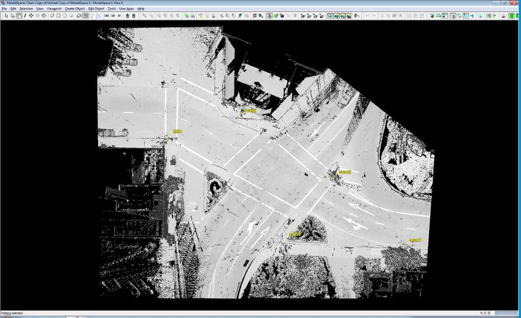
9 Stationary Terrestrial Laser Scanning Stationary Terrestrial Laser Scanning (STLS) refers to laser scanning applications that are performed from a static vantage point on the surface of the earth. The basic concept is similar to that used in total station instruments; using the speed of light to determine distance. However, there are significant differences in laser light wavelength, amount and speed of point data collected, field procedures, data processing, error sources, etc. Laser scanning systems collect a massive amount of raw data called a point cloud. Since a laser scanner is capable of scanning features over long distances, and the accuracy of the scan data diminishes beyond a certain distance, care should be taken to ensure that the final dataset does not include any portion of point cloud data whose accuracy is compromised by measurements outside the useful range of the scanner. Pavement analysis scans to identify issues such as surface irregularities, ADA ramp slopes, utility locations, and drainage need to achieve the same accuracy as conventional surveys (0.03 Horizontal, 0.02 Vertical). In order to achieve those accuracies, OLS has the following recommendations: Recommendations The control must meet the 2cm network accuracy and third order vertical accuracy. (Chapter 5 CSM). The occupied control should be within 100 of the ADA facility. The occupied control must be in the adjusted traverse. Control set by resection should not be used. A minimum of two targeted control points (BS/FS) should be used for each setup. A fine scan must be performed. All debris must be removed from the curb flowline and on or near the ramp. Utilities which may not be clearly visible in the scan should be located using conventional total station survey methods. Page 9 of 16

10 Page 10 of 16
11 Mobile Terrestrial Laser Scanning (MTLS) MTLS method for acquiring data for ADA facilities is used when the replacement of the ramps is part of a larger roadway improvement project, or the number of ramps makes using MTLS the most efficient and effective process for collecting the data. District 11 has been using MTLS for ADA projects. The following recommendations are based on their experience: The acquisition rate, vehicle speed and range should be sufficient to collect points at a high density. The vehicle cannot pick up the features dense enough if it is further than about 1.5 lanes away. Across the street is typically too far. Plan the data collection for the slowest time of the day. Be aware of any peak traffic times and research local bell schedules and other unique vehicle/foot traffic situations that might occur. For most intersections it is necessary to drive both the highway/ramp and the cross-street or drive parallel to the return. Avoid turning too tightly in the MTLS vehicle, which may cause an inside scan line to run backwards, which might cause an issue in certain processing situations. Parallel and overlapping scans should be registered so that they align together within tolerances. MTLS control should be set at the beginning and end of each planned run, at each intersection and elsewhere as appropriate horizontal target spacing is inadequate for the MTLS vehicle speeds common in for this work. Since pull boxes and manhole lids are difficult to read in the scan and accompanying photos, utilities should be measure by conventional or RTK (as appropriate) methods unless both the location and type can be determined without this supplemental data. It is quicker and easier to simply measure and code any features which might be difficult to accurately determine from the cloud/photo. Culvert flowlines should always be measured unless there is certainty that the drainage will not be impacted. All debris in the gutters, back of sidewalk or elsewhere should either be removed or the obscured feature(s) should be collected with conventional total station observations. These lines should start and end where the feature is open for MTLS data so that conformance can be verified Survey control that was used for target observations should be left behind that is sufficient to stake the improvements and conform to the collected data. Field crews should measure validation shots, such as paint strip corners or other obvious features, at each corner. These points should be described sufficiently to avoid confusion in the office. KEY TAKEAWAYS In collecting data for ADA facilities, the procedures are basically the same as they are for typical engineering surveys, it is the amount of data collected that separate s ADA facility surveys from typical engineering surveys. Page 11 of 16
12 CONSTRUCTION SURVEYS Current Policy Caltrans Surveys Manual, Chapter 12 (Construction Surveys) provides staking standards for Caltrans and consultant surveyors on transportation projects. Chapter 12 is included in any construction contract that will require staking. Section details staking intervals and horizontal and vertical staking tolerances for curb stakes. Included in this section is curb returns. The number of stakes set for a curb return is proportional to the length of the return at the flowline. If, for example, the length of the return at the flowline is greater than 20, then the contractor is entitled to stakes at the BCR, ¼D, ½D, ¾D, and ECR. If possible, the construction staking should be done using the same control as the design survey. Staking for ADA ramps will require additional stakes in most cases. The Division of Design has updated Design Information Bulletin (DIB) 82. The new release is The bulletin provides pedestrian accessibility guidelines for highway projects to District Design staff. In addition to DIB 82-06, Headquarters CADD unit has developed general guidelines for curb ramp design (see below). Stake density will depend primarily on the amount of information provided by the Design Engineer. At a minimum, the BCR, ECR, 1/2D and centerline of the ramp should be staked per the example on page 13 General Guidelines for Curb Ramp Design Mandatory. Additional stakes may be set if requested, however it is recommended that the maximum locations staked should be 1/4D s edges of ramp at flowline and edges of ramp at landing. Surveys may be asked to stake angle points on retaining curb if the design calls for it. Typically, construction stakes are set by station/offset from a defined alignment. Per the CADD Manual revision, the Design Engineer has two options when developing the ADA facility design. The first option is to tie the facility(s) to the centerline alignment. This becomes an issue for surveys. All points tied to the centerline alignment will be normal (90 ) to the alignment. For mid-block ramps in tangents this is not a problem. However, most curb ramps are in a curve. Since Surveys does not stake actual locations, but set reference stakes, providing a radial reference stake based on ties to the centerline alignment will only be possible at the BCR and ECR of the curb return. The second option for the design engineer is to tie the ramp to a local alignment, in most cases the flowline of the curb. This option is preferred by Surveys. It allows us to set radial reference stakes by adding or subtracting the reference distance to the offset distance. If the designer used the centerline alignment option, then the recommendation from OLS is for Survey office staff to create local alignments (flowline) for each ramp. Page 12 of 16

13 CADD Construction Detail Examples Page 13 of 16

14 Page 14 of 16

15 Page 15 of 16
16 CONCLUSION The Caltrans Surveys Manual (CSM) provides basic guidance for the engineering and construction surveying for ADA facilities. The editors of the CSM through the years have tried to provide guidance for District Surveys without stifling innovation by dictating absolutes. Over the years, Caltrans has developed institutions designed to increase communication between functional units involved in project development. We have developed checklists and flow charts. By far, the most effective institution is the Project Development Team (PDT). The PDT gives District Surveys the opportunity to work with Design and the PDT on the data collection needs as well as provide guidance on the design for project construction. ADA facility projects may require Surveys to use significantly more resources for the design and construction surveys. Caltrans Surveys program will be constantly challenged to innovate and deliver the ADA facility surveys cheaper and faster. This can be accomplished through the use of good planning, a trained workforce, and application of appropriate technologies. The key actions to take related to this Survey Information Bulletin are as follows Ensure sufficient Surveys involvement in the Project Development Team (PDT). Work through the Project Manager and Design Engineer to develop a plan for the additional resources that ADA projects require. Pre-survey meeting with Design to determine the extent of the ADA facility surveys. Determination of which facilities are known to be non-compliant and which facilities will need to be surveyed to make the compliant / non-compliant determination. Accurate location of utilities within the conform limits of the facility (typically 20 either side). Work with the design engineer to promote the most economical and efficient design for construction staking. Surveys attendance at pre-construction meetings to determine staking density and possible pre/post surveys of ADA facilities. Page 16 of 16
CONSTRUCTION SURVEY. Construction survey includes personnel, equipment, and supplies required for, but not limited to, the following:
 CONSTRUCTION SURVEY PART 1 - GENERAL 1.01 SECTION INCLUDES Construction survey includes personnel, equipment, and supplies required for, but not limited to, the following: A. Construction Survey: 1. Project
SECTION CONSTRUCTION SERVICES
 SECTION 01100 CONSTRUCTION SERVICES PART 1 GENERAL 1.01 - Section Includes A. Mobilization. B. Construction Surveys. C. Record Documents. 1.02 Description Of Work A. Mobilization: includes the preparatory
Alaska Department of Transportation and Public Facilities. Alaska Construction Surveying Requirements (US Customary Units)
") Alaska Department of Transportation and Public Facilities Alaska Construction Surveying Requirements (US Customary Units) Alaska Construction Surveying Requirements Table of Contents Description Page
Alaska Department of Transportation and Public Facilities Alaska Construction Surveying Requirements (US Customary Units) Alaska Construction Surveying Requirements Table of Contents Description Page
SECTION 3 STAKING REQUIREMENTS
 3.01 TOPIC INDEX SECTION 3 STAKING REQUIREMENTS 3.01 INDEX 3.02 PURPOSE 3.03 GENERAL 3.04 STAKING PROCEDURE 3.05 TMWA / DEVELOPER COORDINATION 3.06 WATER STAKING DETAILS 3.07 DEVELOPER RESPONSIBILITIES
STREET IMPROVEMENTS (Refer to Title 18, chapter entitled "STREETS" of the Layton Municipal Code.)
") STREET IMPROVEMENTS (Refer to Title 18, chapter 18.24 entitled "STREETS" of the Layton Municipal Code.) I. Street widths STREET TYPE (ALL MEASUREMENTS IN FEET) ROW WIDTH LAYTON CITY STANDARD STREET SECTIONS
STREET IMPROVEMENTS (Refer to Title 18, chapter 18.24 entitled "STREETS" of the Layton Municipal Code.) I. Street widths STREET TYPE (ALL MEASUREMENTS IN FEET) ROW WIDTH LAYTON CITY STANDARD STREET SECTIONS
Chapter 1. General Design Information. Section 1.02 Structure Selection and Geometry. Introduction
 Chapter 1 Bridge Design Manual General Design Information Section 1.02 Selection and Geometry Introduction Selection or Rehabilitation Report This section of the design manual provides guidance on the
CHAPTER 12 INSTALLATION OF UTILITIES AND OTHER SYSTEMS TABLE OF CONTENTS
 CHAPTER 12 INSTALLATION OF UTILITIES AND OTHER SYSTEMS TABLE OF CONTENTS Section Title Page 12.1 General... 12-1 12.2 Design Standards... 12-1 12.2.1 General Requirements...12-1 12.2.2 Minimum Depth...12-1
CITY OF ANN ARBOR, MICHIGAN Public Services Area/Project Management Unit 301 E. Huron Street P.O. Box 8647, Ann Arbor, Michigan 48107
 CITY OF ANN ARBOR, MICHIGAN Public Services Area/Project Management Unit 301 E. Huron Street P.O. Box 8647, Ann Arbor, Michigan 48107 Web: www.a2gov.org Printed on recycled paper May 17, 2016 Subject:
CONSTRUCTION PLAN CHECKLIST
 CONSTRUCTION PLAN CHECKLIST The design engineer is responsible for ensuring that plans submitted for city review are in accordance with this checklist. It is requested that the executed checklist be submitted
Chapter 7. Street Drainage. 7.0 Introduction. 7.1 Function of Streets in the Drainage System. 7.2 Street Classification
 7. Introduction This chapter summarizes methods to evaluate runoff conveyance in various street cross sections and curb types in the Town of Castle Rock and identifies acceptable upper limits of street
CONSTRUCTION STAKING GUIDELINES
 CITY OF LOS ANGELES DEPARTMENT OF PUBLIC WORKS BUREAU OF ENGINEERING SURVEY DIVISION CONSTRUCTION STAKING GUIDELINES Gary Lee Moore, P.E., City Engineer Tony Pratt, Chief Surveyor TABLE OF CONTENTS Dec.
Curb Ramps [ 4.7.3] [ 4.7.2; 4.8.2; 4.1.6(3)(a)] [ 4.3.7] ADA Accessibility Survey Instructions Curb Ramps Page 1 of 6
![Curb Ramps [ 4.7.3] [ 4.7.2; 4.8.2; 4.1.6(3)(a)] [ 4.3.7] ADA Accessibility Survey Instructions Curb Ramps Page 1 of 6](/thumbs/73/68272859.jpg "Curb Ramps [ 4.7.3] [ 4.7.2; 4.8.2; 4.1.6(3)(a)] [ 4.3.7] ADA Accessibility Survey Instructions Curb Ramps Page 1 of 6") : Curb Ramps 1 [ 4.7.3] Only measure the width of the ramp section of the curb ramp (labeled ramp to the right). The ramp section of a curb ramp is also known as the ramp run. If the curb ramp has flared
: Curb Ramps 1 [ 4.7.3] Only measure the width of the ramp section of the curb ramp (labeled ramp to the right). The ramp section of a curb ramp is also known as the ramp run. If the curb ramp has flared
3.0 DESIGN CRITERIA FOR SANITARY SEWER FACILITIES
 3.0 DESIGN CRITERIA FOR SANITARY SEWER FACILITIES All sanitary sewers shall be designed in accordance with these Design Standards, LBWD Rules and Regulations, and to accepted engineering principles. In
Section 7 Roadway GENERAL REQUIREMENTS I. TYPICAL SECTION...7-1
 Section 7 Roadway GENERAL REQUIREMENTS...7-1 I. TYPICAL SECTION...7-1 7.1 LANE WIDTHS...7-1 7.2 SHOULDER WIDTHS...7-1 7.3 CROSS SLOPE...7-2 7.4 CURB AND UNDERDRAINS...7-2 7.5 SIDEWALKS AND DRIVEWAYS...7-2
Intro. ADA Operations Contact Info
 Intro ADA Operations Contact Info Todd Grugel ph: 651-366-3531 email: todd.grugel@state.mn.us Joe Zilka ph: 651-366-3311 email: joseph.zilka@state.mn.us Harvey Unruh ph: 651-216-2912 email: harvey.unruh@state.mn.us
Section 1 OBC FADS /13 Access to Parking Areas
 Section 1 OBC 3.8.2.2 4.3.12/13 Access to Parking Areas A barrier-free path of travel is provided from: a) the entrance to the exterior parking area b) at least one parking level where a passenger elevator
T a b l e o f C o n t e n t s
 C i t y o f G l a d s t o n e P u b l i c W o r k s D e s i g n S t a n d a r d s T a b l e o f C o n t e n t s SECTION THREE SANITARY SEWER REQUIREMENTS... 1 3.0000 SANITARY SEWERS... 1 3.0010 General
EXHIBIT A SCOPE OF SERVICES FOR DISTRICT-WIDE TRAFFIC OPERATIONAL STUDIES FOR INNOVATIVE INTERSECTION AND INTERCHANGE TREATMENTS
 EXHIBIT A SCOPE OF SERVICES FOR DISTRICT-WIDE TRAFFIC OPERATIONAL STUDIES FOR INNOVATIVE INTERSECTION AND INTERCHANGE TREATMENTS Financial Project No.: 436382 1 32 02 Revised: 09/11/18 09/10/18 EXHIBIT
TOWN OF MANCHESTER PLANNING AND ZONING COMMISSION Subdivision Application Minimum Submission Requirements
 TOWN OF MANCHESTER PLANNING AND ZONING COMMISSION Subdivision Application Minimum Submission Requirements This checklist is to be completed and submitted with all Subdivision Applications. The Town reserves
Exhibit A Scope of Work
 1.0 Purpose: The purpose of the contract is to provide a Construction Project Engineer, Senior Inspector Roadway, and two certified G&B inspectors, as needed, to assist State staff on S.P. 0120-24 during
Construction Documents Checklist
 Construction Documents Checklist The following must be completed prior to final approval of site development plans (Construction Documents) by the Town: Final Drainage Report signed by engineer-of-record
This is only a general checklist; please refer to the CVWD Development Design Manual (DDM) for all requirements and regulations.
 for all requirements and regulations.") COACHELLA VALLEY WATER DISTRICT DOMESTIC WATER CHECKLIST Tract/Parcel No: Project Common Name: Developer: Engineer: Engineer Signature: Date: Phone: Phone: Print: This is only a general checklist; please
COACHELLA VALLEY WATER DISTRICT DOMESTIC WATER CHECKLIST Tract/Parcel No: Project Common Name: Developer: Engineer: Engineer Signature: Date: Phone: Phone: Print: This is only a general checklist; please
Hosted by: M Squared Engineering on behalf of the Illinois Department of Transportation Thursday, February 9, 2012 Eiger Lab, Rockford, IL
 Hosted by: M Squared Engineering on behalf of the Illinois Department of Transportation Thursday, February 9, 2012 Eiger Lab, Rockford, IL TECHNICAL SUPPORTIVE SERVICES IN IDOT DISTRICTS 2 & 3 FOR CERTIFIED
SECTION 14 - RESTORATION OF SURFACES TABLE OF CONTENTS
 SECTION 14 - RESTORATION OF SURFACES TABLE OF CONTENTS Section Page SECTION 14 RESTORATION OF SURFACES... 14.1 14-1 GENERAL... 14.1 14-2 PRIVATE ROADS... 14.1 14-3 STREETS AND PARKING LOTS... 14.1 14-3.01
CHAPTER 70 PUBLIC WORKS DEPARTMENT DEVELOPMENT STANDARDS ARTICLE 70 BASIC PROVISIONS
 CHAPTER 70 PUBLIC WORKS DEPARTMENT DEVELOPMENT STANDARDS ARTICLE 70 BASIC PROVISIONS 70.010 - PURPOSE The purpose of this chapter is to establish standards for the design and development of sites in order
COUNTY OF YUBA DEPARTMENT OF PUBLIC WORKS IMPROVEMENT STANDARDS
 COUNTY OF YUBA DEPARTMENT OF PUBLIC WORKS IMPROVEMENT STANDARDS TABLE OF CONTENTS SECTION 1 PURPOSE AND DEFINITIONS 1.1 PURPOSE:... 1 1.2 DEFINITIONS:... 1 SECTION 2 GENERAL REQUIREMENTS 2.1 PLANS BY AN
Chapter 3: Permit Procedures and Requirements
 Chapter 1: General Provisions 1 1 Short Title 1 2 Jurisdiction 1 3 Amendments and Revisions 1 4 Enforcement Responsibility 1 5 Review Process 1 6 Prior Approval 1 7 Relationship to Other Standards 1 8
Exhibit A Scope of Work. 0.0 Separation of work Types and Cost Estimate
 0.0 Separation of work Types and Cost Estimate Exhibit A Scope of Work 0.1 Prepare scope of work and cost estimate for MnDOT efforts relating to all items numbered less than 20.0. 0.2 Prepare scope of
CHAPTER 5 WATER SYSTEM DESIGN STANDARDS
 CHAPTER 5 WATER SYSTEM DESIGN STANDARDS TABLE OF CONTENTS CHAPTER 5 WATER SYSTEM DESIGN STANDARDS 5.00 Objective Page 1 5.01 Additional Referenced Standards Page 1 5.02 Special Design Problems Page 2 5.03
 Construct each curb ramp using Type A1 Use curb ramps with flared sides at locations with wide sidewalks. NOTES Construct each curb ramp using Type A2 Construct each curb ramp using Type A1 PERPENDICULAR
DOWNTOWN OXNARD PARKLET PILOT PROGRAM PARKLET DESIGN GUIDELINES
 Development Services Planning Division 214 South C Street Oxnard, California 93030 (805) 385-7858 Fax (805) 385-7417 DOWNTOWN OXNARD PARKLET PILOT PROGRAM PARKLET DESIGN GUIDELINES I. INTRODUCTION As part
Review of Plans and Specs from a Constructability Perspective
 Review of Plans and Specs from a Constructability Perspective The Executive Regional Manager and the Project Manager, with approval of the Director of Project Management, may request the Constructability
Final Estimates Level 2. Module 5: Earthwork Computations
 Florida Department of TRANSPORTATION Final Estimates Level 2 Module 5: Earthwork Computations 11/1/2017 FDOT Final Estimates Level 2 Release 11, Module 5 1 5-1 Module Content Basic Earthwork Terminology
APPENDIX B STANDARD CONSTRUCTION DRAWING NOTES
 APPENDIX B STANDARD CONSTRUCTION DRAWING NOTES B-1 General Notes: SACWSD Standard Construction Drawing Notes 1. No work shall begin on any water or wastewater construction project until the construction
Intro. ADA Operations Contact Info
 Intro ADA Operations Contact Info Todd Grugel ph: 651-366-3531 email: todd.grugel@state.mn.us Joe Zilka ph: 651-366-3311 email: joseph.zilka@state.mn.us Harvey Unruh ph: 651-216-2912 email: harvey.unruh@state.mn.us
Department of Building and Zoning Approaches and Sidewalks for ONE AND TWO FAMILY CONSTRUCTION
 Department of Building and Zoning Approaches and Sidewalks for ONE AND TWO FAMILY CONSTRUCTION GENERAL ITEMS SUBGRADE Prior to pouring concrete all subgrades must be wetted and compacted. All formwork
APPLICATION FOR PUBLIC INFRASTRUCTURE PERMIT
 APPLICATION FOR PUBLIC INFRASTRUCTURE PERMIT Engineering Division 550 Landa Street New Braunfels, Texas 78130 (830) 221-4020 1. Subdivision Plat Name: Location Description/ Nearest Intersection: Acreage:
PART II - SURVEYING AND GRADING CRITERIA
 PART II - SURVEYING AND GRADING CRITERIA A. Surveying Procedures 1. Unless a temporary benchmark is approved in advance by the City Engineer, all submitted civil plans, including but not limited to grading,
B510-5 REMOVAL-PAVEMENT WORK OPSS 510. CDED B Removal CDED B Reclaim Asphalt Pavement
 B510-5 OPSS 510 510-5.1 GENERAL This section is for Pavement Work removal tender items. The work covered by these tender items includes the removal and disposal of materials. 510-5.2 REFERENCES CDED B510-0
SECTION 6. ROAD CONSTRUCTION STANDARDS
 SECTION 6. ROAD CONSTRUCTION STANDARDS Construction of new roads or reconstruction of existing roads proposed for dedication to the County shall conform to the standards set forth in this section. Roads
STORM DRAINAGE DESIGN MANUAL
 Appendix I STORM DRAINAGE DESIGN MANUAL by: SUNGATE DESIGN GROUP, P.A. GEN ERAL DESIGN STAN DARDS AN D POLICIES 1. STREET AND LOCAL DRAINAGE Discharge estimates for specified design storms shall be calculated
Control Survey Procedures
 Chapter 13 Control Survey Procedures 13-01 General 13-02 Policy Control surveys establish a common, consistent network of physical points that are the basis for controlling the horizontal and vertical
Table of Contents. Section 11,010 - Construction Survey Section Includes Description of Work Submittals 1. 1.
 SUDAS Standard Specifications Table of Contents Section 11,010 - Construction Survey Page No. Part 1 - General 1.01 Section Includes 1 1.02 Description of Work 1 1.03 Submittals 1 1.04 Substitutions 2
B510-5 REMOVAL-PAVEMENT WORK OPSS 510. CDED B Removal CDED B Reclaim Asphalt Pavement
 B510-5 OPSS 510 510-5.1 GENERAL This section is for Pavement Work removal tender items. The work covered by these tender items includes the removal and disposal of materials. 510-5.2 REFERENCES CDED B510-0
CITY OF CAMDENTON OFFICE OF THE BUILDING OFFICIAL Commercial Building & Architectural Review Permit Application
 CITY OF CAMDENTON OFFICE OF THE BUILDING OFFICIAL Commercial Building & Architectural Review Permit Application DATE: / / PERMIT # REQUEST FOR: NEW BUILDING ADDITION REMODEL PLUMBING ONLY ELECTRIC ONLY
Exhibit A Mn/DOT Contract No
 Exhibit A Mn/DOT Contract No. 98142 SCOPE OF WORK AND DELIVERABLES Preliminary Design Red Wing US 63 Bridge and Approach Roadways State Project (SP) 2515-21 SCOPE OVERVIEW... 2 SCHEDULE... 2 PROJECT TASK
EVALUATION OF 3-D LASER SCANNING EQUIPMENT: 2016 INTERIM REPORT
 CIVIL ENGINEERING STUDIES Illinois Center for Transportation Series No. 17-013 UILU-ENG-2017-2013 ISSN: 0197-9191 EVALUATION OF 3-D LASER SCANNING EQUIPMENT: 2016 INTERIM REPORT Prepared By Gregary Renshaw,
TH 25 Bituminous Mill, Full Depth Reclamation and Overlay SP &
 TH 25 Bituminous Mill, Full Depth Reclamation and Overlay SP 4910-29 & 0504-14 Contract No. 1002252 Project Overview is in need of professional and technical assistance to provide detail design for State
STATE UNIVERSITY CONSTRUCTION FUND
 DIRECTIVE 2-1 Issue date: September 2012 1. General SITEWORK OVERVIEW This Directive outlines the Fund s requirements for the Consultant relative to the development, design and presentation of documents
Part 1. Construction Tolerances COPYRIGHTED MATERIAL
 Part 1 Construction Tolerances COPYRIGHTED MATERIAL Figure 1 1 Horizontal building layout Chapter 1 Building Layout and Sitework 1 1 Horizontal Building Layout Description One of the first sources of inaccuracies
Fundamentals of Jointing for Volume Change in Concrete
 Fundamentals of Jointing for Volume Volume Changes in Concrete Concrete is at its greatest volume when it is freshly placed. As the concrete cures and hardens, water is consumed in the chemical reaction
Chapter 8. Inlets. 8.0 Introduction. 8.1 General
 . Introduction This chapter provides criteria and design guides for evaluating and designing storm sewer inlets in the City of Centennial. The review of all planning submittals will be based on the criteria
CITY OF LOS ANGELES Sidewalk Repair Program. Amber Elton, PE
 CITY OF LOS ANGELES Sidewalk Repair Program Amber Elton, PE Sidewalk Repair Program Civil Engineer APRIL 20, 2017 Century Plaza Towers 2029 Century Park East City s Goal BEFORE AFTER Improve Mobility in
Section 13. Guidelines for the Design of Ground Mounted Sign Supports
 Section 13 BDC11MR-04 13.1 Introduction Highway signs fall into two main categories, which are subdivided as follows: 1. Overhead Signs a. Sign Bridge Structures (GO) b. Sign Cantilever Structures (GO)
SECTION 26 - COLD PLANE ASPHALT CONCRETE PAVEMENT TABLE OF CONTENTS
 SECTION 26 - COLD PLANE ASPHALT CONCRETE PAVEMENT TABLE OF CONTENTS Section Page 26-1 GENERAL... 26.1 26-2 PAVEMENT KEYCUTTING... 26.1 26-3 PAVEMENT PLANING... 26.2 26-4 PLANED PAVEMENT CONFORMS... 26.3
CITY OF PANAMA CITY BEACH Utilities Administration & Engineering Offices 116 South Arnold Road Panama City Beach, FL 32413
 Page: 1 of 5 CITY OF PANAMA CITY BEACH Utilities Administration & Engineering Offices 116 South Arnold Road Panama City Beach, FL 32413 COMMERCIAL/RESIDENTIAL UTILITY PLAN COMPLETENESS CHECK LIST Updated
ROADWAY DESIGN AND CONSTRUCTION STANDARDS
 ROADWAY DESIGN AND CONSTRUCTION STANDARDS Adopted: 1990 Amended: 1994 2003 2011 2013 ROADWAY DESIGN AND CONSTRUCTION STANDARDS ORIGINALLY ADOPTED IN 1990 Resolution No. R-990-046 OFFICIALLY AMENDED IN
TRANSPORTATION & PUBLIC WORKS DEPARTMENT TECHNICAL STANDARDS
 Athens-Clarke County Unified Government TRANSPORTATION & PUBLIC WORKS DEPARTMENT TECHNICAL STANDARDS JULY, 2009 PREFACE The technical standards presented herein reflect the current policies and practices
B. Subsurface data is available from the Owner. Contractor is urged to carefully analyze the site conditions.
 SECTION 31 23 33 - TRENCHING, BACKFILLING AND COMPACTION PART 1 - GENERAL 1.1 SCOPE A. This Section specifies the requirements for excavating and backfilling for storm sewer, sanitary sewer, water distribution
SUBDIVISION SECTION STREET DESIGN MANUAL
 CITY OF ANAHEIM SUBDIVISION SECTION STREET DESIGN MANUAL A. INTRODUCTION : POLICY STATEMENT B. STREET CLASSIFICATION C. STREET STANDARDS REQUIREMENTS Requirements Approval of Street Improvement Plans Widening
8. Vertical Alignment (Profiles).
.") 8. Vertical Alignment (Profiles). a. Cover Over Pipeline. 1) Normal depth for sewer pipelines is eight (8) to ten (10) feet measured from the lowest profile grade or ground line. 2) Provide a minimum of
8. Vertical Alignment (Profiles). a. Cover Over Pipeline. 1) Normal depth for sewer pipelines is eight (8) to ten (10) feet measured from the lowest profile grade or ground line. 2) Provide a minimum of
SITE ACCESSIBILITY AND PARKING
 SITE ACCESSIBILITY AND PARKING The purpose of this handout is to clarify the requirements of site accessibility under the 2013 California Building Codes, Specifically, Section 11B. Each lot or parking
CHAPTER 4 GRADE SEPARATIONS AND INTERCHANGES
 CHAPTER 4 GRADE SEPARATIONS AND INTERCHANGES 4.0 INTRODUCTION The ability to accommodate high volumes of intersecting traffic safely and efficiently through the arrangement of one or more interconnecting
603 - ASPHALT PAVEMENT SMOOTHNESS SECTION 603 ASPHALT PAVEMENT SMOOTHNESS
 SECTION 603 ASPHALT PAVEMENT SMOOTHNESS 603.1 DESCRIPTION Determine the smoothness of the pavement surface and correct the deficiencies as specified in the Contract Documents. For the purposes of this
UNIFORM STANDARD DRAWINGS CLARK COUNTY AREA, NEVADA YEAR 2015 REVISIONS
 , NEVADA YEAR 2015 REVISIONS SECTION TITLE AND REVISIONS SUMMARY EFFECTIVE DATE 217.S2 "Residential Curb and Gutter, R-Type" - New drawing to accommodate ADA requirements. 223 "Residential Driveway" -
CITY OF DANA POINT SITE ACCESSIBILITY AND PARKING B103 SITE INTRODUCTION
 INTRODUCTION CITY OF DANA POINT COMMUNITY DEVELOPMENT, BUILDING AND SAFETY 33282 Golden Lantern, Suite 209 Dana Point, CA 92629 949 248-3594 www.danapoint.org SITE ACCESSIBILITY AND PARKING B103 SITE 2013
COUNTY OF ALBEMARLE. Community Development Department 401 McIntire Road, Room 227 Charlottesville, Virginia (434)
") COUNTY OF ALBEMARLE ZONING INFORMATION PACKET (For building permits for a structure on a property with a site plan) Community Development Department 401 McIntire Road, Room 227 Charlottesville, Virginia
COUNTY OF ALBEMARLE ZONING INFORMATION PACKET (For building permits for a structure on a property with a site plan) Community Development Department 401 McIntire Road, Room 227 Charlottesville, Virginia
Accessible Parking. Scoping and Technical Requirements
 Accessible Parking Scoping and Technical Requirements Pacific ADA Center Toll Free: 1-800-949-4232 (V/TTY) www.adapacific.org adatech@adapacific.org 2017 Pacific ADA Center 2 General Overview Design and
ODOT ADA Program 10/31/2017. Recent ADA outcomes. What you need to know. Settlement Agreement approved. Updated Transition Plan
 Recent ADA outcomes What you need to know ODOT ADA Program Lisa Strader, ODOT ADA Program Manager Settlement Agreement approved Updated Transition Plan What does it mean? Public Transportation Advisory
T-WALL Retaining Wall System
 CONSTRUCTION MANUAL T-WALL Retaining Wall System The T-WALL Solution... THE NEEL COMPANY 8328 Traford Lane Springfield, VA 22152 Phone 703-913-7858 Fax 703-913-7859 T-WALL Retaining Wall System CONSTRUCTION
SPECIAL PROVISIONS - SP2014 BOOK Page 1 October 8, 2013
 SPECIAL PROVISIONS - SP2014 BOOK Page 1 S-1 (2104) REMOVE AND REPLACE BITUMINOUS PAVEMENT (ADA) Always include SP2014-119 (PLANT MIXED ASPHALT PAVEMENT) or SP2014-121 (PLANT MIXED ASPHALT PAVEMENT FOR
CITY OF LA QUINTA GENERAL NOTES GENERAL NOTES
 CITY OF LA QUINTA GENERAL NOTES GENERAL NOTES 1. ALL WORK SHALL BE DONE IN ACCORDANCE WITH THE LATEST EDITION OF THE STANDARD PLANS OF THE CITY OF LA QUINTA, THE LATEST EDITION OF THE STANDARD SPECIFICATIONS
CITY OF BENICIA IMPROVEMENT PLAN REVIEW CHECKLIST
 CITY OF BENICIA DEPARTMENT OF PUBLIC WORKS ENGINEERING DIVISION 250 EAST L STREET, BENICIA, CA 94510 Phone: (707) 746-4240 CITY OF BENICIA IMPROVEMENT PLAN REVIEW CHECKLIST Tract Map # This checklist is
UTILITIES CHECKLIST CITY OF CHESAPEAKE DEPARTMENT OF PUBLIC WORKS SUBDIVISION NAME: A/C & TAX MAP PARCEL NOS (13 DIGITS) DEVELOPER:
 DEVELOPER:") UTILITIES CHECKLIST CITY OF CHESAPEAKE DEPARTMENT OF PUBLIC WORKS SUBDIVISION NAME: A/C & TAX MAP PARCEL NOS (13 DIGITS) DEVELOPER: REVIEWING ENGINEER: WATERSHED (INCLUDE SUBSCRIPT) I. PRELIMINARY ITEMS
UTILITIES CHECKLIST CITY OF CHESAPEAKE DEPARTMENT OF PUBLIC WORKS SUBDIVISION NAME: A/C & TAX MAP PARCEL NOS (13 DIGITS) DEVELOPER: REVIEWING ENGINEER: WATERSHED (INCLUDE SUBSCRIPT) I. PRELIMINARY ITEMS
CITY OF ASTORIA PUBLIC WORKS ENGINEERING DIVISION ENGINEERING DESIGN STANDARDS FOR IN-FILL DEVELOPMENT
 CITY OF ASTORIA PUBLIC WORKS ENGINEERING DIVISION ENGINEERING DESIGN STANDARDS FOR IN-FILL DEVELOPMENT Adopted by City Council: May 21, 2007 X:\General Eng\DESIGN STANDARDS\Engineering Design Standards
(D) Surface Slope Bituminous patch in front of the truncated domes must not exceed 5% measured perpendicular to the flow line or edge of roadway.
 Surface Slope Bituminous patch in front of the truncated domes must not exceed 5% measured perpendicular to the flow line or edge of roadway.") Last Revision by CO Special Provisions: 09/14/18 Page 1 S-1 (2104) REMOVE AND REPLACE BITUMINOUS PAVEMENT (ADA) Always include SP2018-143 ((2360) PLANT MIXED ASPHALT PAVEMENT (MSCR)) when using this writeup.
Last Revision by CO Special Provisions: 09/14/18 Page 1 S-1 (2104) REMOVE AND REPLACE BITUMINOUS PAVEMENT (ADA) Always include SP2018-143 ((2360) PLANT MIXED ASPHALT PAVEMENT (MSCR)) when using this writeup.
SECTION CONCRETE CURBS, GUTTERS AND SIDEWALKS. A. Formwork complete with shoring, bracing and anchorage.
 SECTION 02528 CONCRETE CURBS, GUTTERS AND SIDEWALKS PART 1 GENERAL 1.01 WORK INCLUDED A. Formwork complete with shoring, bracing and anchorage. B. Concrete reinforcement complete with required supports,
B STEEL BEAM GUIDE RAIL - OPSS 721
 B721-2 - - OPSS 721 721-2.1 GENERAL Design guidance and a description of Steel Beam Guide Rail systems, including various types and treatments, are provided in the Roadside Design Manual (RDM). 721-2.2
I-35W Retaining Wall Design Exhibit A - Draft Scope of Work
 Background MnDOT, Metro Transit, Hennepin County, and the City of Minneapolis are in the process of developing a project for Interstate 35W between 43 rd Street in Minneapolis and 15 th Street in Minneapolis.
ITEM 6 CONCRETE CURBS, GUTTERS, AND SIDEWALKS
 ITEM 6 CONCRETE CURBS, GUTTERS, AND SIDEWALKS 6.1 DESCRIPTION This work shall consist of constructing curbs, gutters, sidewalks, ramps, local depressions and driveways of the form and dimensions shown
CUYAHOGA COUNTY DEPARTMENT OF PUBLIC WORKS CUYAHOGA COUNTY ENGINEER TOWNSHIP SUBDIVISION STREET DESIGN STANDARDS AND IMPROVEMENT PLAN REQUIREMENTS
 CUYAHOGA COUNTY DEPARTMENT OF PUBLIC WORKS CUYAHOGA COUNTY ENGINEER TOWNSHIP SUBDIVISION STREET DESIGN STANDARDS AND IMPROVEMENT PLAN REQUIREMENTS November 25, 2013 Table of Contents Cuyahoga County Engineer's
SUBDIVISION CHECKLIST. Subdivision Name. Prior To Review. Preliminary plan approved by Planning Commission / Council as required.
 SUBDIVISION CHECKLIST Subdivision Name Account Number Review Engineer Prior To Review Preliminary plan approved by Planning Commission / Council as required. Review fee paid. Statement of Responsibility
ZONING CLEARANCE PLAN REVIEW CHECKLIST. Based on the Revised Town of Carefree Zoning Ordinance
 ZONING CLEARANCE PLAN REVIEW CHECKLIST Based on the Revised Town of Carefree Zoning Ordinance Date: Applicant: Permit Number: Reviewer: Address: Lot & Subdivision: Zoning District: New SRF: Addn/Remodel:
Project: Developer/Designer: Reviewer:
 City of Charlottesville, Virginia Engineering Plan Review Checklist (Site Plans, Site Plan Amendments, and Major Subdivisions) 610 East Market Street, Charlottesville, VA 22902 Telephone 434-970-3182;
IGGA Guide Specification: Conventional Diamond Grinding of City Streets Introduction
 IGGA Guide Specification: Conventional Diamond Grinding of City Streets Introduction This standard developed, by the International Grooving and Grinding Association (IGGA), specifies the procedures for
CONSTRUCTION MANUAL. T-WALL Retaining Wall System FOR RAILROAD PROJECTS. The T-WALL Solution...
 T-WALL Retaining Wall System CONSTRUCTION MANUAL FOR RAILROAD PROJECTS T-WALL railroad units are 5.0' high x 7.5' wide. (stem lengths will vary) The T-WALL Solution... T-WALL Retaining Wall System CONSTRUCTION
PART II. - SPECIFICATIONS AND DESIGN STANDARDS TO CITY OF HEWITT, TEXAS SUBDIVISION ORDINANCE FOR PUBLIC WORKS CONSTRUCTION [TEXT]
![PART II. - SPECIFICATIONS AND DESIGN STANDARDS TO CITY OF HEWITT, TEXAS SUBDIVISION ORDINANCE FOR PUBLIC WORKS CONSTRUCTION [TEXT]](/thumbs/80/81891816.jpg "PART II. - SPECIFICATIONS AND DESIGN STANDARDS TO CITY OF HEWITT, TEXAS SUBDIVISION ORDINANCE FOR PUBLIC WORKS CONSTRUCTION [TEXT]") PART II. - SPECIFICATIONS AND DESIGN STANDARDS TO CITY OF HEWITT, TEXAS SUBDIVISION ORDINANCE FOR PUBLIC WORKS CONSTRUCTION [TEXT] A. - General. B. - Streets. C. - Stormwater drainage system. D. - Water
PART II. - SPECIFICATIONS AND DESIGN STANDARDS TO CITY OF HEWITT, TEXAS SUBDIVISION ORDINANCE FOR PUBLIC WORKS CONSTRUCTION [TEXT] A. - General. B. - Streets. C. - Stormwater drainage system. D. - Water
20 North Main Alpine, UT (Phone) (Fax) SITE PLAN
 (Fax) SITE PLAN") Site Plan Instructions New Home Form #1 20 North Main Alpine, UT 84004 801-756-6347 (Phone) 801-756-1189 (Fax) www.alpinecity.org SITE PLAN A detailed site plan, drawn to scale, 1 = 20 min., shall be filed
Site Plan Instructions New Home Form #1 20 North Main Alpine, UT 84004 801-756-6347 (Phone) 801-756-1189 (Fax) www.alpinecity.org SITE PLAN A detailed site plan, drawn to scale, 1 = 20 min., shall be filed
B STEEL BEAM GUIDE RAIL - OPSS.PROV 721
 B721-2 - - OPSS.PROV 721 721-2.1 GENERAL Steel beam guide rail (SBGR) is a semi-rigid barrier system which restrains and redirects vehicles by a combination of beam bending (W-shaped steel section), tension,
APPENDIX C INLETS. The application and types of storm drainage inlets are presented in detail in this Appendix.
 Storm Drainage 13-C-1 APPENDIX C INLETS 1.0 Introduction The application and types of storm drainage inlets are presented in detail in this Appendix. 2.0 Inlet Locations Inlets are required at locations
CHAPTER 18 TEMPORARY ROADS AND BRIDGES
 Change #1 - Revised 12/12 CHAPTER 18 TEMPORARY ROADS AND BRIDGES 18.0 INTRODUCTION These guidelines are to be used to design temporary roads and bridges where traffic will be maintained at the construction
Page 1D-1 Revised language to link from Project Management Manual to Project Management Online Guide.
 IMPERIAL ROAD DESIGN MANUAL REVISIONS July 2008 CHAPTER 1D Page 1D-1 Revised language to link from Project Management Manual to Project Management Online Guide. CHAPTER 2A Page 2A-3 Revised language to
Guidelines for Design of Potable Water Distribution Facilities In New Developments
 Guidelines for Design of Potable Water Distribution Facilities In New Developments Prepared by: OUC Water Business Unit Water Resources and Engineering Division Latest Update: September 29, 2009 1. Development
SECTION GENERAL EXCAVATION
 02210-1 of 11 SECTION 02210 GENERAL EXCAVATION 02210.01 GENERAL A. Description 1. General excavation shall include but not necessarily be limited to, excavation and grading for general site work, roadways,
UNIT: ROAD MAINTENANCE & OPERATIONS
 COUNTY OF FRESNO PS&E/CONSTRUCTABILITY REVIEW CHECKLIST UNIT: ROAD MAINTENANCE & OPERATIONS I certify that a thorough and complete constructability review has been performed by my staff: Signature of Functional
12 DRAINAGE General Administrative Requirements Standards
 12 DRAINAGE 12.1 General The Design-Builder shall conduct all Work necessary to meet the requirements associated with drainage, including culverts, bridge hydraulics, roadway ditches, and closed storm
DIVISION 2 SITE DEVELOPMENT DESIGN CONSIDERATIONS SECTION DESIGN GUIDELINES DUVAL COUNTY PUBLIC SCHOOLS
 DIVISION 2 SITE DEVELOPMENT DESIGN CONSIDERATIONS SECTION 02001 Bus Traffic. Separation between bus traffic, regular vehicular flow, service traffic and pedestrian traffic. Bus traffic must have adequate
Intersection Joint Layout
 Intersection Joint Layout Designers and contractors should outline an intersection layout while developing project plans. The initial plan view of an intersection provides the best birds-eye view for seeing
APPENDIX A DESIGN SPECIFICATIONS FOR NEW ROAD CONSTRUCTION
 APPENDIX A DESIGN SPECIFICATIONS FOR NEW ROAD CONSTRUCTION 1. GENERAL SPECIFICATIONS 1.1 Specifications: Plans shall be prepared by a professionally registered engineer duly authorized to conduct business
GRADING & DRAINAGE PERMIT SOIL EROSION AND SEDIMENTATION CONTROL PERMIT PROGRAM OVERVIEW
 GRADING & DRAINAGE PERMIT SOIL EROSION AND SEDIMENTATION CONTROL PERMIT PROGRAM OVERVIEW Chapter 8 Building and Building Regulations, Article XIII Grading and Drainage and Article XV Soil Erosion and Sedimentation