submitted by DIRECTORATE GENERAL OF SEA TRANSPORTATION OF THE REPUBLIC OF INDONESIA
|
|
|
- Cecilia Jefferson
- 5 years ago
- Views:
Transcription


1 submitted by DIRECTORATE GENERAL OF SEA TRANSPORTATION OF THE REPUBLIC OF INDONESIA 7TH COOPERATION FORUM UNDER THE COOPERATIVE MECHANISM ON SAFETY OF NAVIGATION AND ENVIRONMENTAL PROTECTION IN THE STRAITS OF MALACCA AND SINGAPORE LANGKAWI, MALAYSIA 22 SEPTEMBER 2014
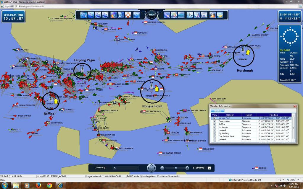
2 Growing Traffic of the Straits Characteristics of the Straits Efficient Passage through the Straits Biodiversity of the Straits Ratification of UNCLOS, SOLAS & MARPOL Marine Incidents and Oil Pollutions in the Straits STRAITREP 1
 2012-2014 Enhancement by")
3 1996 Concept of MEH MOU on Development of Regional MEH-DP (3LS & IMO) - MOA (3LS, IHO, INTERTANKO, ICS) 2006 Implementation MEH-DP 2012 Hand Over MEH Data Center in Batam by SG-IMO (Supported by IMO & ROK) Enhancement by 3 LS 2
4 Links shore-based marine information and communication infrastructure Enable the integration of marine environmental management and protection systems Precision navigation system (ENC, ECDIS, DGPS and AIS Network) Allows for an integrated digital navigation for the provision of vital marine information such as tides and current to ships on a "real-time" basis 3


5 Enhance maritime services, improve navigational safety and security and promote marine environment protection and the sustainable development and use of the coastal and marine resources of the straits' littoral states, indonesia, malaysia and singapore. Enhance the transparency of navigation and overall traffic control and will provide a basis for intensive monitoring of the real-time situation of navigation, which would help in the efforts of relevant countries to reduce piracy and armed robbery in the straits and enhance maritime security throughout the region 4

6 5
7 6
8 INTEGRATED MARINE INFORMATION SYSTEM that utilizes information system based technology so that it is OPEN FOR FURTHER EXPANSION as well as integration with other data, communication and information systems. STRATEGIC MODALITY for the FUTURE IMPROVEMENT of Safety of Navigation and Marine Environmental Protection in regard with current international concerns and developed issues such as the development of e-nav, UKC-RTM, global single windows, higher accuracy PNT, shore based (cloud) information center for the benefit of navigating vessel and shipping industries, and in particular the increasing of marine traffic and activities. 7
9 Intensify the operation of the MEH-SOMS and the use of services it provides Sustainable operation and improvement of operational performance Gaps on the implementation of sustainable operation and performance improvement Gaps on the preparedness for expansion of service and integration with other technologies and systems 8
10 Capacity building Development of standard operation and procedure Development of manual for users Standardization for system architecture, applications, database and data exchange interface Invite voluntary or recommendatory participation Exploration of the most possible, affordable and reliable data transmission network 9
11 Management, Operator and Technical Trainings Study and Formulation of Standard, Manual and SOP Study and Formulation of the Straits Network Formulation of Concept for Effective Implementation of MEH through the Continuous Participation of Ships 10
12 Sustainable and reliable operation, effective implementation and optimized utilization of the MEH-SOMS Progressively actuate and provides more guarantee on the effective and successful implementation of any high-technology based system for the improvement of safety of navigation and environmental protection in the Straits Enhanced preparedness of system and human resources for future implementation of advance technology to support the safety of navigation and environmental protection for the international navigation in the Straits. 11


13