Section 3. Self-Evaluations and Transition Plans. Agency Requirements. Agency Requirements. Overview. Legal Language ( 28 CFR Part 35)
|
|
|
- Erin Ford
- 5 years ago
- Views:
Transcription
1 and Transition Plans Section 3 and Transition Plans Fall, 2017 Ann Johnson, PE Services Brady Rutman, SRF Consulting Group Overview Agency Requirements What is a Self-Evaluation? What, When and How to Document Projecting Time and Cost Best Practices and Examples Transition Plans What s Included in a Transition Plan? Timing of Improvements Examples & Resources 2 Agency Requirements Agency Requirements Only required for public entities that employ 50 or more persons Legal Language ( 28 CFR Part 35) Self Evaluation ( 28 CFR ) Evaluate current services, policies, and practices and make necessary modifications to meet requirements Provide an opportunity to interested persons to participate in selfevaluation process by submitting comments Maintain on file and make available for public inspection for at least 3 years following self-evaluation: A list of interested persons consulted A description of areas examined and any problem(s) identified A description of any modifications made These requirements do not need to duplicate compliance required by Section 504 of the Rehabilitation Act 3 Legal Language ( 28 CFR Part 35) Self Evaluation ( 28 CFR ) Evaluate current services, policies, and practices and make necessary modifications to meet requirements Provide an opportunity to interested persons to participate in selfevaluation process by submitting comments Maintain on file and make available for public inspection for at least 3 years following self-evaluation: A list of interested persons consulted A description of areas examined and any problem(s) identified A description of any modifications made These requirements do not need to duplicate compliance required by Section 504 of the Rehabilitation Act 4 1
 Make information of this part available to applicants, participants, beneficiaries, and other interested persons Agency Requirements Only required for public entities that employ 50 or more")
 Make information of this part available to applicants, participants, beneficiaries, and other interested persons Designation of Responsible Employee and Adoption of Grievance Procedures ( 28 CFR")
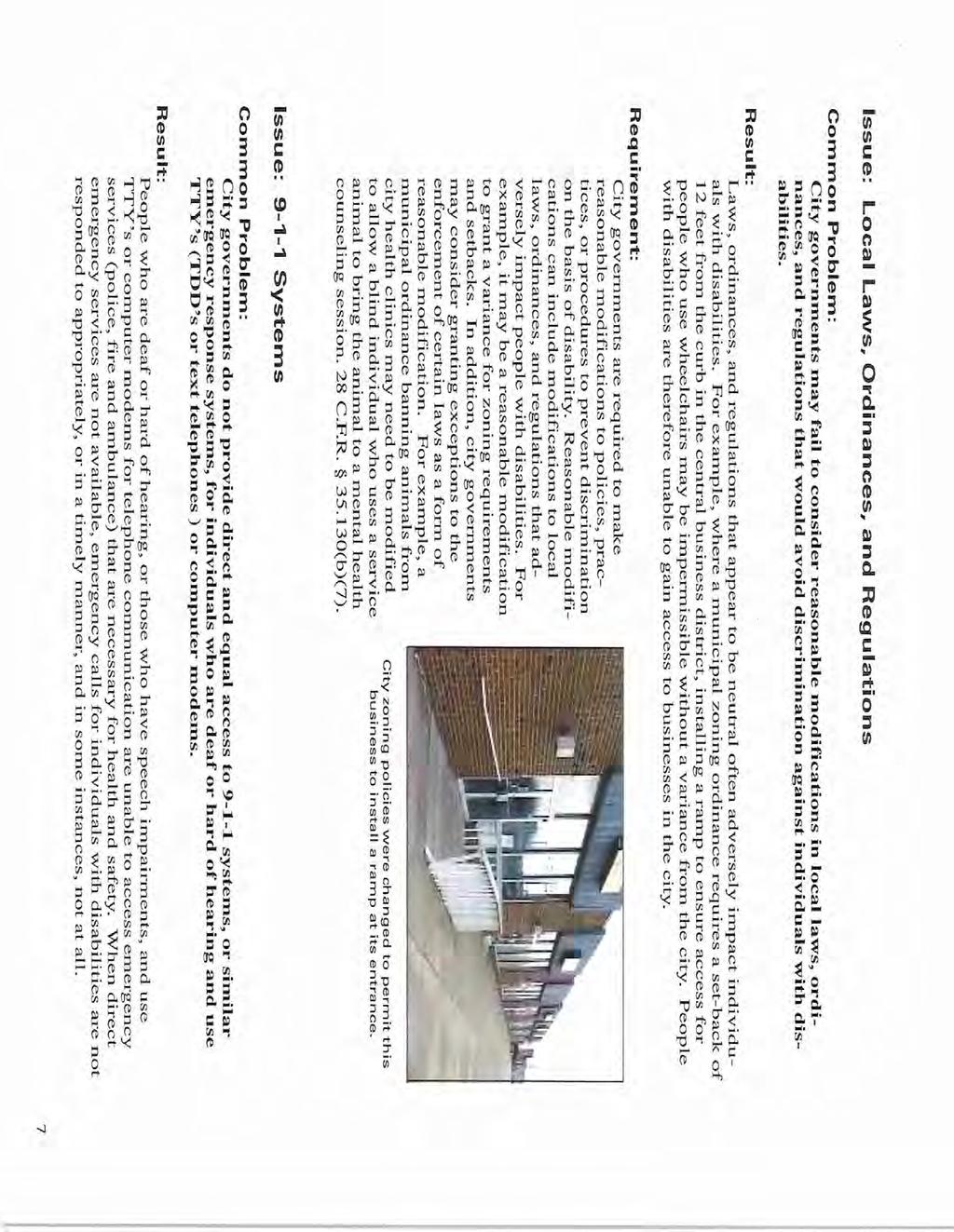
2 Agency Requirements Legal Language ( 28 CFR Part 35) Notice ( 28 CFR ) Make information of this part available to applicants, participants, beneficiaries, and other interested persons Agency Requirements Only required for public entities that employ 50 or more persons Legal Language ( 28 CFR Part 35) Notice ( 28 CFR ) Make information of this part available to applicants, participants, beneficiaries, and other interested persons Designation of Responsible Employee and Adoption of Grievance Procedures ( 28 CFR ) Designate at least one employee to coordinate these efforts and carry out responsibilities, including investigation of any complaint Name Office Address Telephone Number Adopt and publish grievance procedures 5 6 Agency Requirements Only required for public entities that employ 50 or more persons Legal Language ( 28 CFR Part 35) Existing Facilities ( 28 CFR subpart d) Develop a Transition Plan setting forth the steps necessary to complete changes required to achieve program accessibility Provide an opportunity to interested persons to participate in the development of a transition plan by submitting comments Make available a copy of the transition plan for public inspection Overview What is a Self-Evaluation? What to Document How to Document Projecting Time and Cost Best Practices and Advice 7 8 2

 Title II, ADA 28 CFR 35 (DOJ) Purpose: To identify barriers in programs and activities that prevent persons")
3 & Scoping What to evaluate: Consider the needs of your City/County What information will help you meet those needs? Design your Self-Evaluation to lead your Transition Plan Think about your business needsf. What will help your business be successful? Evaluation = This is what we have Transition Plan = This is how we re making progress What is a Self-Evaluation? Required of all public entities Section 504, Rehabilitation Act of CFR 27 (USDOT) Title II, ADA 28 CFR 35 (DOJ) Purpose: To identify barriers in programs and activities that prevent persons with disabilities from access 9 10 What to evaluate: All programs and facilities that require public access Public right-of-way Rest Areas, Parks, Trails Access to Public Buildings Barriers to Accessibility Critical Areas End Product Inventory of facilities where structural modifications are needed to make them accessible Unspecified Format Enough detail to form foundation of Transition Plan Presentation Options: Aerial Photos Database/Spreadsheet Marked-up Drawings Geographic Information System (GIS)


4 End Product: Summary Table End Product: Detailed Spreadsheet End Product: Images End Product: GIS Maps


5 What to Document Presence of Communication Devices and Services What to Document Barriers to Access Barriers to Access Identify Barriers to Access within: Sidewalks Shared-Use Trails Pedestrian Crossings Curbs (Curb Ramps) Pedestrian Signals Parking Lots Bus Stops Construction Zones


6 What to Document: Sidewalks and Trails Running Slope Cross-Slope Geometry Width Turning Space Condition Vertical Discontinuities Cracking/Crumbling What to Document: Ramps and Stairs Running Slope & Cross Slope Landings & Turning Space Geometry Width Tread/Riser Design Handrails Edge Protection Condition Vertical Discontinuities Cracking/Crumbling Surface Characteristics 23 What to Document: Ramps and Stairs 24 6


7 What to Document: Pedestrian Signals Presence Location Ease of Activation What to Document: Parking Lots Number and Location of Accessible Stalls Signage/Marking Slope Location and Connection to Ped Access Route What to Document: Parking Lots Number & Location of Accessible Stalls Signage/Marking Slope What to Document: Parking Lots


8 What to Document: Bus and Transit Stops Accessible Route to Waiting Pad or Shelter Landing Detectable Warnings Seating Wheel Chair Space Auditory and Tactile Travel Information What to Document: Bus and Transit Stops What to Document: Bus and Transit Stops 31 What to Document: Construction Sites Temporary Pedestrian Accessible Route Smooth Surfaces Width Grades Landings and Turning Spaces Detectable Edging Edge Protection Tripping Hazards or Obstacles Handrails Audible Message Devices 32 8


9 What to Document: Curb Ramps Running Slope Cross-Slope Geometry Type of Ramp Width Landing Detectable Warnings Ramp Flares Condition Vertical Discontinuities Cracking/Crumbling 33 What to Document: Curb Ramps In general, compliance can be achieved by meeting 12 requirements: 1. Ramp Width 4 min or match incoming sidewalk/trail 2. Ramp Running Slope Less than or equal to 8.3% 3. Ramp meets Spec (Construction Requirements for Concrete Walk) 4. Ramp Cross Slope Less than or equal to 2% 5. Gutter Flow Line Slope If the gutter flow line slope is greater than 2%, then the ramp cross slope will also exceed 34 What to Document: Curb Ramps 6. Landing Slope Can not exceed 2% in any direction 7. Landing Dimensions 4 ft. by 4 ft. minimum 8. Landing Location At the top of the ramp and/or change in PAR direction 9. Truncated Domes Properly oriented and covering the entire curb opening 10. Proper drainage Not holding water, especially in PAR 11. Vertical Discontinuities None greater than ¼ inch 12.Walkable Surface Flare Slope Must be 10% max 13.(Bonus)F Ramp Location Maintain PAR continuity 35 What to Document: Curb Ramps 36 9


10 What to Document: Curb Ramps What to Document: Curb Ramps What to Document: Curb Ramps What to Document: Curb Ramps


11 What to Document: Curb Ramps What to Document: Curb Ramps What to Document: Curb Ramps What to Document: Curb Ramps


12 What to Document: Curb Ramps What to Document: Curb Ramps What to Document: Curb Ramps What to Document: Curb Ramps


13 What to Document: Curb Ramps What to Document: Curb Ramps What to Document: Curb Ramps How to Document: Optimal: On-ground Surveys Additional Methods: Windshield Surveys Aerial Photo Studies Record Drawing Reviews


14 On-ground Surveys Windshield Surveys Aerial Photos Record Drawing Reviews


15 Documentation & Organization Documentation & Organization Documentation & Organization How to Document Brooklyn Park Instructional Video:
 Your method and approach to the inventory How many staff? What technology?")
 Data Collection: ~30-40 data points per hour, team of 2 Including Data Analysis: ~25 data points per hour")
16 Projecting Time and Cost Your agency s commitment will vary depending on: The size/area of your City/County The type of pedestrian infrastructure featured The density of pedestrian infrastructure (rural/urban) Your method and approach to the inventory How many staff? What technology? The depth of data you seek Projecting Time and Cost MnDOT Guidelines (State Average) Sidewalks: ~1 hour/1 mile Curb Ramps: ~20 mins/intersection Signalized Intersection (with APS and Curb Ramps): ~1 hour/intersection Projecting Time and Cost Example from the City of Hopkins (2017) Data Collection: ~30-40 data points per hour, team of 2 Including Data Analysis: ~25 data points per hour Sidewalks: One data point per driveway location (or 1 point per block with no driveways) Curb Ramps: 1 data point per ramp APS Push Button: 1 data point each Urban intersection: ~45 minutes Residential intersection: ~20 minutes Projecting Time and Cost Example from Clay County (2014) Sidewalks: 2-3 miles per day Curb Ramps: 15 mins/quadrant, mins/intersection

_fr.")
17 Projecting Time and Cost Example from Hennepin County ( ) Sidewalks: 368 miles over 2 summers with 2 interns Curb Ramps: 13,000 ramps over ~1 year with 1 vehicle GIS software program, Trimble GPS device used Linked photos and checklist with locations Best Practices National Cooperative Highway Research Program (NCHRP) ADA Transition Plans: A Guide to Best Management Practices MnDOT Local Agencies Best Practices NCHRP: Common Areas of Non-Compliance

18 Best Practices US DOJ: Common Problems for Local Agencies City governments believe existing programs and facilities are protected by grandfather clause City governments must provide program access for people with disabilities to the whole range of city services and programsf unless undue burden Small municipalities believe they are exempt from complying with Title II of ADA due to size All public entities, regardless of size, must comply with Title II requirements ( 28 CFR ) If less than 50 employees, compliance not required with sections of DOJ regulations 69 Best Practices US DOJ: Common Problems for Local Agencies City governments often fail to ensure the whole range of the city s services, municipal buildings, and programs are accessible (Public meetings, City functions, etc.) Accessibility can be achieved in a variety of ways: Structural changes Move public meetings to accessible buildings Relocate services for individuals with disabilities to accessible levels or parts of buildings 70 Best Practices US DOJ: Common Problems for Local Agencies City governments often do not provide enough curb ramps City governments often fail to provide qualified interpreters or assistive listening devices at public events/meetings City governments often fail to provide materials in alternate formats (Braille, large print, audio cassettes, etc.) City governments often fail to consider reasonable modifications in local laws/ordinances/regulations that would avoid discrimination against individuals with disabilities City governments do not provide direct and equal access to systems Law enforcement agencies often fail to modify policies, practices, or procedures in citizen interaction, detention, and arrest procedures 71 Best Practices MnDOT GPS DATA Fields (See Handout) 72 18
 Condition Rating Guides 1. Excellent 2. Good 3.")


19 Best Practices MnDOT GPS DATA Fields (See Handout) Best Practices MnDOTGPS DATA Fields (See Handout) Condition Rating Guides 1. Excellent 2. Good 3. Fair 4. Poor Best Practices Lessons from Local Agencies Identify Priority Areas based on: Citizen requests/complaints Population density Pedestrian level of service Incidence of disabilities Cost Be strategic with first steps; get the most out of your effort considering limited time/budget Best Practices Lessons from Local Agencies Concentrate effort at High-Priority Areas Gather information from the public and advocacy groups to identify inaccessible areas Use summer interns Store data with GIS Geolocation not required, but helpful Makes for easier ongoing assessment updates


20 Self Evaluations Best Practices Lessons from Local Agencies Avoid reinventing the wheel Look at other plans online Use consultant experience Adopt a two-pronged approach to deal with rights-of-way separate from buildings Consider separating pedestrian infrastructure into categories to help funding decisions: Excellent-Good-Average-Fair-Poor-Failing Example: City of Baxter, MN Self Evaluations Self Evaluations Example: City of Baxter Example: City of Baxter

21 Self Evaluations Self Evaluations Example: Sibley County Self Evaluations Self Evaluations Example: Clay County Example: Clay County


22 Self Evaluations Self Evaluations Example: Hennepin County Self Evaluations Self Evaluations Example: Hennepin County

23 Self Evaluations Self Evaluations Example: Hennepin County Example: Hennepin County Transition Plans Overview What s included in a Transition Plan? Timing of Improvements Tips and Resources Transition Plans & Scoping Linking Self-Evaluation to Transition Plan Consider the needs of your City/County What information will help you meet those needs? Design your Self-Evaluation to lead your Transition Plan Think about your business needsf. What will help your business be successful? Evaluation = This is what we have Transition Plan = This is how we re making progress
) Purpose: To set forth steps necessary to complete modifications identified through self-evaluation (those areas not covered by")


24 Transition Plans Transition Plans What is a Transition Plan? Required of public entities that employ at least 50 persons ( 28 CFR (d)) Purpose: To set forth steps necessary to complete modifications identified through self-evaluation (those areas not covered by a previous plan) Provide a schedule for completing the modifications 93 What s included in a Transition Plan? Minimum Agency Requirements: Identify physical obstacles in the public entity that limit accessibility Describe in detail the methods to make facilities accessible Specify the schedule for achieving compliance If longer than one year, identify steps for each year Indicate an official responsible for plan implementation Input from interested individuals and organizations 94 Transition Plans Transition Plans What s included in a Transition Plan? For those public entities with responsibility for streets, roads, or walkwaysf Transition plan shall include a schedule for providing curb ramps What s included in a Transition Plan? No requirements for format of the Transition Plan Sample Outline:


25 Transition Plans Transition Plans What s included in a Transition Plan? No requirements for format of the Transition Plan Sample Outline: 97 Timing of Improvements Evaluation is ongoing; Transition Plan is a living document Transition Plan to be utilized in yearly planning of projects and funding decisions Periodic review for compliance and validity No specific requirement for frequency of updates Best Practices are different from minimum requirements Always look for opportunities Coordination Other Agencies Transit Agencies Contractors, Designers Advocacy Groups 98 Transition Plans Transition Plans Timing of Improvements Curb Ramps to be installed/replaced in conjunction with ROW Alterations (FHWA/DOJ Joint Technical Assistance) Timing of Improvements Curb Ramps to receive special consideration with a separate schedule for remediation Example: Prioritization (Based on Self-Evaluation Results) Highest Priority: Existing Curb Ramp with Running Slope >12% (or No Curb Ramp) near Hospital, School, Govt Building, Senior Housing, Etc. Lowest Priority: Pedestrian Push Button not Accessible from Sidewalk or Ramp; Existing Curb Ramp without Truncated Domes


26 Transition Plans Transition Plans Example: City of Baxter Example: Hennepin County Transition Plans Transition Plans Example: Hennepin County Example: Hennepin County


27 Transition Plans Transition Plans Example: Clay County Example: Clay County Transition Plans Transition Plans Example: Clay County

28 Transition Plans Lessons Learned from Local Agencies Getting Started Staff and Funding Public Involvement Coordination Transition Plans Lessons Learned - Getting Started: Working with a Consultant Assistance with approach and organization Assistance with drafting the Transition Plan Assistance with interpreting requirements Community Outreach and Coordination Staffing Hire Interns! Identify Critical or Priority Areas Others Transition Plans Transition Plans Lessons Learned - Possible Funding Sources: Incorporate accessibility improvements into existing programmed work Remediation, Signalization, or Maintenance Projects Develop a stand alone Accessibility Improvement Program Through the Transportation Improvement Program Other Funding: Highway Safety Improvement Program Railway-Highway Crossing Program Recreational Trail Program Safe Routes to School Program State and Community Traffic Safety Program Surface Transportation Program Transportation Enhancement Activities Program

29 Transition Plans Transition Plans Lessons Learned - Public Involvement: Disseminate Transition Plan and relevant information on websites For the general public Targeted distribution to advisory groups and participants of the process Seek early involvement of Advocacy groups and the disabled public Valuable information for prioritization Transition Plans Lessons Learned -Coordination with Other Agencies and Departments Creation of a regional working group for ADA compliance issues Forum for ideas and best management practices Discussion format for resolving issues of jurisdiction Develop relationships with other local governments Contact list of ADA Coordinators Transition Plans Resources US Department of Justice ADA Information and Technical Assistance ADA BEST PRACTICES TOOLKIT FOR STATE AND LOCAL GOVERNMENTS THE AMERICANS WITH DISABILITIES ACT, TITLE II TECHNICAL ASSISTANCE MANUAL, COVERING STATE AND LOCAL GOVERNMENT PROGRAMS AND SERVICES MnDOT Federal Highway Administration Accessibility Resource Library DESIGNING SIDEWALKS AND TRAILS FOR ACCESS PART 2. OFFICE OF CIVIL RIGHTS QUESTIONS AND ANSWERS ABOUT ADA AND SECTION United States Access Board A Federal Agency Committed to Accessible Design PUBLIC RIGHTS-OF-WAY ACCESS ADVISORY COMMITTEE and ITE Publication Special Report: ACCESSIBLE PUBLIC RIGHTS-OF-WAY, PLANNING AND DESIGNING FOR ALTERNATIONS REVISED GUIDELINES FOR ACCESSIBLE PUBLIC RIGHTS-OF-WAY Great Lakes ADA Center Resource to increase Awareness and Knowledge of ADA Compliance
30 Transition Plans Resources Local Road Research Board Transition Plan Template d=3921&type=project

31

32

33

34

35

36
37
38
39
40
41 THE NATIONAL ACADEMIES National Academy of Sciences National Cooperative Highway Research Program NCHRP PROJECT NUMBER 20-7 (232) ADA Transition Plans: A Guide to Best Management Practices Jacobs Engineering Group Baltimore, MD
42 SELF EVALUATION CHECKLIST ISSUE Sidewalk and Pathway Clear Width Sidewalk and Pathway Cross Slope Landings Along Sidewalks and Pathways Sidewalk and Pathway Grade Materials and Finishes Gratings Discontinuities Detectable Warning System Obstructions Traffic Signal Systems Curb Ramp Curb Ramp Flares Narrow, Below Guidelines Possible Barriers Steepness, Irregularity, Variability, Warping Less Than 4 feet by 4 feet Steepness, Angle Points Deterioration of Surfaces, Deterioration of Markings, Appropriateness of material (ex. Cobblestones) Grating Type, Grate Opening Orientation Missing Sections, Gaps, Drops, Steps Missing, Inappropriate Materials, Inadequate Size, Wrong Location Signs, Mail Boxes, Fire Hydrants, Benches, Telephones, Traffic Signal Poles, Traffic Signal Controller Boxes, Newspaper Boxes, Drainage Structures, Tree Grates, Pole Mounted Objects, Standing Water, Snow or Ice Lack of Provision for the Visually Impaired such as APS, Inadequate Time Allowed, Inoperable Buttons, Inaccessible Buttons Missing, Doesn t Fall within Marked Crosswalk, Doesn t Conform to Guidelines Missing Where Required, Too Steep Standards set for each of these issues can be found in the US Architectural and Transportation Barriers Compliance Board s Accessible Rights-of-Way: A Design Guide, Chapter 3 Best Practices in Accessible Rights-of-Way Design and Construction. Refer to their website at for more information. The information developed through the inventory process has to be quantified and presented as a baseline so that progress can be monitored and measured. The inventory information can be presented in a variety of ways including Aerial Photos, a Database or Spreadsheet, Marked Up Drawings, or a Geographic Information System (GIS). Page 5
43 PRIORITY Highest 1A 1B 2A 2B Situation Existing Curb Ramp with Running Slope Greater than 12% and Location near a Hospital, School, Transit Stop, Government Building, or Similar Facility No Curb Ramp where Sidewalk or Pedestrian Path Exists and Location near a Hospital, School, Transit Stop, Government Building, or Similar Facility An Existing Curb Ramp with a Running Slope Greater than 12% (Not Located near a Hospital or Similar Facility) No curb ramp where a Sidewalk or Pedestrian Path Exists (Not Located near a Hospital or Similar Facility) 3 No Curb Ramp where a Striped Crosswalk exists 4 One Curb Ramp per Corner and Another is Needed to Serve the Other Crossing Direction 5A An Existing Curb Ramp with either a Running Slope Greater than 1 to 12 or an Insufficient Landing 5B 5C 5D 5E 5F Lowest An Existing Curb Ramp with Obstructions in the Ramp or the Landing An Existing Curb Ramp with any of the Following Conditions: o A Cross Slope Greater than 3% o A Width Less Than 36 Inches o No Flush Transition or a Median or Island Crossings that are Inaccessible An Existing Curb Ramp with Returned Curbs where Pedestrian Travel Across the Curb is not Permitted An Existing Diagonal Curb Ramp without the 48 Inch Extension in the Crosswalk An Existing Curb Ramp without Truncated Dome Texture Contrast or without Color Contrast The Pedestrian Push Button is not Accessible from the Sidewalk or from the Ramp Page 13
44 The following is a sample of one possible outline for Transition Plans. SECTION I SELF EVALUATION : II CORRECTION PROGRAM: III IMPLEMENTATION SCHEDULE: IV PROGRAM RESPONSIBIL ITY: V CURB RAMP CORRECTION PROGRAM: VI PUBLIC INVOLVEMENT RECORD: contents A list of physical barriers in the department s facilities that limit accessibility of individuals with disabilities. This may take the form of an Excel spreadsheet or GIS files incorporated by reference, or can be worked into a narrative list to be embedded in the text of the Transition Plan. A detailed description of the methods to remove these barriers and make the facilities accessible. A schedule for taking the necessary steps. The name of the official responsible for implementation. This should include the name of the department ADA coordinator, as well as a transition plan team (if there is one), or the regional coordinators, if the inventory and transition plans area is divided by region or district. A schedule for providing curb ramps. Record of the opportunity given to the disability community and other interested parties to participate in the development of the Plan. ATTACHMENTS PUBLIC INVOLVEMENT The Department is required to provide an opportunity for people outside of the agency, people with disabilities, and other interested individuals and organizations to review and comment on the Transition Plan. This section presents some of the approaches agencies have used to provide this opportunity. The Dissemination of Information: Although all Departments now have websites, very few have the Transition Plan available for public review. This represents a missed opportunity as an avenue for information dissemination. In addition to providing information for the public at large, the targeted distribution of information should also be undertaken. Advisory groups that may have worked with the Department during the development of the Plan and the prioritization of the upgrades would receive the information. Advocacy groups that work with the disabled community, as well as any individuals with disabilities that may have participated in Plan development in some way (ex. through grievance filings, through hotlines or through previous public meetings), would also be interested in reviewing the plan. Page 16
45 NATIONAL COOPERATIVE HIGHWAY RESEARCH PROGRAM (NCHRP) ADA TRANSITION PLANS: A GUIDE TO BEST MANAGEMENT PRACTICES A compilation of all the Keys to Success from the original 47-page document Providing dedicated, trained staff within the Department for ADA compliance has a high correlation with successful drafting and implementation of Transition Plans, Self- Evaluations, and Transition Plan updates. Provide a website with links to the various components of the ADA Transition Plan such as policies, compliance planning for construction and retrofits, opportunities for public participation, links to the ADA advisory committee, grievance procedures, and the schedule for implementation of the program. One state found that public meetings on the newly completed inventory were better attended when they were coupled with another meeting geared toward the disabled community such as linking the meeting with a regularly scheduled meeting of the Statewide or Local Commission on Disabilities. Making the grievance procedure as straightforward as possible for the public can facilitate information exchange regarding non-compliant sites, and can help the Department avoid escalation of grievance issues. By allowing the public to choose any method of filing a grievance, from writing a formal complain to the ombudsman, filing a complaint electronically through the website, contacting any Department business office, or calling a toll-free number, the Department ensures a better exchange of information. When staffing or funding for inventory efforts is a challenge many Departments get creative several states have reported using summer interns for self-evaluation activities on public rights-of-way. Others prioritize the inventory process by looking at high pedestrian areas first. In this way, even if a complete inventory cannot be undertaken, those areas that will be most utilized (such as urban intersections) are addressed. A very detailed approach for setting priorities for dealing with curb ramps (or other non conformities) can help with successful implementation of the Plan. Criteria can include both physical characteristics and location considerations. Making use of such specific criteria presupposes that sufficient detail has been gathered in the self-evaluation phase so that the curb ramps can be accurately characterized. One state s approach to prioritization uses a GIS database that contains information regarding compliant and non-compliant elements. This GIS information is then 1
46 displayed along with locations of pedestrian incidents, feedback from the community or local jurisdiction, locations of government facilities, locations of public facilities and mass transit stops. Each of these elements were assigned a value and ranked for priority. Working closely with advocacy groups to set the schedule for implementation and prioritization can be extremely beneficial. These groups can help bring information from the public to the Departments so that money can be best spent on those areas that will serve to benefit the most people. Beyond simply designating an ADA Coordinator, many Departments have a designated Transition Plan manger, as well. While the ADA Coordinator may be involved in public outreach and oversight of ADA compliance, the Transition Plan manager may be better equipped to handle the technical aspects related to the self-evaluation activities and Transition Plan updates. Length and level of detail of Transition Plans varies greatly among the states. For example, one state provides a succinct one and a half page of narrative on rights-ofway and the prioritization criteria, incorporating the inventory by reference. Other states have a Transition Plan that provides pages and pages of actual inventory with priorities and proposals for each individual site. At the outset of the process, a Department should make a determination as to what level of detail will be included in the Plan and the content that will be the most beneficial to them in implementing ADA Seeking the involvement of Advocacy groups and the disabled public early in the process can lead to better success in dealing with non-compliance areas. This early coordination can provide valuable information to the Department from people who most use the pedestrian facilities and provides and opportunity for the concerns that are most important to the advocacy groups and the public to be addressed more effectively. These groups know best where problem areas are and their input can provide valuable insight to Departments that are trying to set priorities for upgrades. Creation of a regional working group for ADA compliance issues was cited by several states in the east as being a helpful practice in completing tasks related to the Transition Plan. These interstate groups are made up of an ADA coordinator as well as other members of Departments and FHWA. The meetings provide a forum for exchange of ideas and any Best Management practices. The groups exchange ideas in their approach to developing inventories and updating Transition Plans. Regional grouping also enables common challenges among the states to be more effectively addressed. Densely urbanized areas in the Northeast, with miles of urban sidewalks interspersed with public transit have different pedestrian issues than newer cities in the Southwest. For example, Washington State deals with an entirely different pedestrian issue in managing the nations largest ferry system. Creating regional work groups can facilitate discussion of common regional problems. 2


47 Curb Ramp Inventory Data Fields Pedestrian Ramp, Pedestrian Landing, and Curb and Gutter are collected using one GPS Pedestrian Ramp Intersection ID Pedestrian Activity: Type of Activity occurring at the corner the point is being taken Ramp Type Type in the cross street Residential Church School Public Building: Post Office, City Hall, Museum, etc Retail: Restaurant, Shops, Gas station, grocery, etc. Business Other: Dentist, office buildings, etc Recreation: Parks, etc Vacant Other None Diagonal: A single curb ramp that is located at the apex of the corner at an intersection. It is aligned so that a straight path of travel down the ramp will lead diagonally into the center of the intersection, the ramp is diagonal to the user s path of travel, and users will be traveling diagonal to the vehicular traffic when they enter the street at the bottom of the ramp. Perpendicular: A curb ramp that is aligned so that the ramp is generally perpendicular to the curb, and users will generally be traveling perpendicular to vehicular traffic when they enter the street at the bottom of the ramp Compliant Measure Depressed Corner: Depressed corners gradually lower the level of the sidewalk, through an almost undetectable change in slope, to meet the grade of the street. Depressed corners are often designed as an expanded diagonal curb ramp that extends around the entire corner at the intersection. Fan: Fan type quadrants are a variation of a Depressed Corner with the main difference being that the first 3 ft. to 4 ft. of the ramp is sloped up to 8.3% through the detectable warning portion with a flat 4 ft. x 4 ft. landing at the top.

 Parallel: A parallel curb ramp has two ramps leading down towards a center level landing at the bottom between both ramps with a level landing at the top of each ramp.")


48 Tiered: A combination of ramps of either the same type or different types. All secondary ramps can be classifed as a parallel ramp whether it rises out of a depress corner, rises out of a combined perpendicuar, transitions curb and gutter or transitions of a standard ramp when there is insufficient sidewalk width (usually less than 10 ft.) Parallel: A parallel curb ramp has two ramps leading down towards a center level landing at the bottom between both ramps with a level landing at the top of each ramp. A parallel curb ramp is one that is oriented so that the path of travel on the ramp is parallel to the vehicular path of travel on the adjacent street; and the user s path of travel on the sidewalk. One-Way Directional: A directional ramp is used when there is only one pedestrian access route approaching the intersection and only one direction to cross the intersection. Flat landing Location Other None: If there is a sidewalk or trail leading up to the intersection but no curb ramp Intersection Corner Median: The area between two divided roadways measured from edge of traveled way to edge of traveled way Mid-block: Crossing that does not occur at a road intersection Pork Chop: Raised concrete refuge usually found between right turns and through-fare travel lanes Bump-out: An extension of the curb line in a bulb-like rounding radius that incorporates curb ramps Other


49 4' Pedestrian Access Yes Route (PAR) Maintained No Landing Area: A level None area of walkway at the 4'x4' top or bottom of a Less than 4'x4' ramp that allows Greater than 5'x5' wheelchair users space to orient their direction before and after using a ramp. Landing Slope Perpendicular to Ramp Running slope taken perpendicular to the curb ramp at the midpoint 4' x 4' or greater 2% or less Landing Slope Parallel to Ramp Cross slope taken parallel to the curb ramp at the mid-point. 2% or less Measure the ramp width from one flare to the other Ramp Width: (inches to the nearest inch) Truncated Domes: A surface feature built in or applied to the walking surface to indicate an upcoming change from pedestrian to vehicular way. Does the curb ramp have compliant truncated domes? Running Slope (% to nearest tenth): The grade that is parallel to the direction of accessible pedestrian travel Cross slope (% to nearest tenth): The grade that is perpendicular to the direction of accessible pedestrian travel Running Slope 2 (% to nearest tenth): The grade that is parallel to the direction of accessible pedestrian travel Cross slope 2 (% to nearest tenth): The grade that is perpendicular to the direction of accessible pedestrian travel Running Slope 3 (% to nearest tenth): The grade that is parallel to the direction of accessible pedestrian travel Yes: Domes span the entire width of the ramp, are intact, and are within 2 feet of the curb cut. No: If more than 25 % of the domes have failed or if the orientation or width is wrong or domes are missing Measure the running slope at the midpoint of the curb ramp Measure the cross slope at the midpoint of the curb ramp For Tiered and Parallel Ramps For Tiered and Parallel Ramps For Tiered Ramps 48" min 8.3% or less 2% or less 8.3% or less 2% or less 8.3% or less

50 Cross slope 3 (% to nearest tenth): The grade that is perpendicular to the direction of accessible pedestrian travel Condition Rating For Tiered Ramps 1: No cracks, no obstacles, less than 1/4" lip at curb line 2: No cracks, no obstacles, lip at curb line between 1/4" & 1/2" 3: Cracks create unlevel ramp surface, weeds may be present in cracks 4: Ramp has multiple cracks creating rough terrain, concrete chunks missing or surface is spalling, obstacles create difficult navigation, curb lip is more than 1/2" 2% or less Condition Rating of 1 or 2 Gutter Inslope (% to nearest tenth) Gutter Flow Line (% to nearest tenth ) Condition Rating Why is ramp not compliant (For inspectors) Comments Photo What is the slope of the gutter measured perpendicular to the middle of the curb cut from the flow line towards the street? What is the slope of the gutter flow line measured from one flare to the other flare of the curb ramp? 1: Uniform slopes, no noticeable cracks, no vertical discontinuities, no spalling, joints intact 2: Uniform slopes, some cracks, vertical discontinuities less than 1/4", no spalling, joints intact 3: Gutter slope beyond flare flows back towards curb ramp at < 1.5%, some large cracks and minor spalling, noticeable vertical discontinuities, joints beginning to deteriorate 4: Gutter slope beyond flare flows back towards curb ramp at > 1.5%, many cracks, multi-directional, excessive spalling, excessive vertical discontinuities, joints badly deteriorated, > 1/2" vertical discontinuities Surface Utilities Loadbearing Structure Geography Underground Utilities Contract Error Other 5% or less 2% or less Condition Rating of 1 or 2 Crosswalk : Take the GPS point for the crosswalk in the middle of the intersection if crossing is permitted. Marked Crosswalk: Yes Is there a painted No crosswalk across this leg of the intersection? Yes Pedestrian Ramp No within Crosswalk N/A - Check if there is no marked crosswalk Types of Marking None Crosswalk Leg: What type of road does the crosswalk cross? 2 Parallel Stripes Zebra Diagonal Other Mn/DOT Road: This includes Trunk Highways (TH) and US highways Non - Mn/DOT road: This includes city, county, township; and forest roads
51 Width (ft to nearest foot) Pavement Condition Rating Comments What is the width of the marked crosswalk from paint edge to paint edge? Record 0 if there is no marked crosswalk 1: Smooth pavement within crosswalk 2: Minimal cracking within crosswalk 3: > 1/4" vertical discontinuity at gutter/pavement joint 4: Pavement patching needed due to 1/2" horizontal cracks or potholes Signal: If this is a signalized intersection, record a GPS point for each direction of travel. If the intersection is not signalized, there is no need to open this attribute. If there are push buttons, record the point at the button and if there are not push buttons, record the point at the signal pole. Intersection Description Type in the cross street Pedestrian Activity: Type of Activity occurring at the corner the point is being taken Connect to Pedestrian Access Route (PAR) APS (Accessible Pedestrian Signal: Signal that communicates information about the WALK phase in audible and vibrotactile formats. Walk Signal: Does the signal have a pedestrian signal head? Countdown: Does the pedestrian signal head display the number of seconds to cross street? Residential Church School Public Building: Post Office, City Hall, Museum, etc Retail: Restaurant, Shops, Gas station, grocery, etc. Business Other: Dentist, office buildings, etc Recreation: Parks, etc Vacant Other None Yes No N/A Yes No N/A - Check if there is no pedestrian signal head Yes No N/A Check if there is no pedestrian signal head Yes No N/A - Check if there is no pedestrian signal head Pedestrian Phase: Do Automatic you need to push the Activation required pedestrian button to N/A: Check if there is no button make the WALK phase begin or does it automatically change to walk when the light turns green? Button Location: Where is the pedestrian push button located? None Traffic signal pole Pedestal station Other Pole Location Outside edge of crosswalk Inside edge of crosswalk Button Landing Area: Yes Is the paved surface 2- No - Check if any of the conditions are untrue 1/2' x 4'? N/A - Check if there is no button
52 Button Landing Slope: Does the landing area Yes have a slope of 2% or No - Check if any of the conditions are untrue less in each direction N/A - Check if there is no button Button With Ramp: Button Location coincides with ramp - is the button on the same side of the pole as the ramp Button Height What is the height of the button from the ground to the middle of the button? (inches to nearest 1/2") Yes No N/A - Check if there is no button Button Reach: Is the paved landing area within a 10" reach Yes No - Check if any of the conditions are untrue N/A - Check if there is no button Button Back of Curb: Is the button between Yes 18" and 10 feet from No - Check if any of the conditions are untrue the back of the curb N/A - Check if there is no button Button Horizontal Location: Is the button no more than 5' from the outside edge of crosswalk Yes No - Check if any of the conditions are untrue N/A - Check if there is no button Buttons Min 10' Yes Apart: If there are two No push buttons, are they N/A - Check if there are not two buttons or if the signal is at least 10 feet apart? not APS Is the button 6' from the back of the curb? Is the button 5' horizontally from the curb ramp Comments Photo Sign: Record a GPS point only if there is a midblock crossing, otherwise there is no need to open this attribute Intersection ID Type in the two streets it is between No Flashing Yellow Lights at Midblock Crossings Comments Yes-continuous - Are the light continuously flashing? Yes-activated - Do you need to push a button to make the lights flash?


53 Condition Rating: Curb Ramp 1: Excellent No cracks, no obstacles, less than ¼ lip at curb line 2: Good- No cracks, no obstacles, lip at curb line between ¼ and ½ 3: Fair Cracks create unlevel ramp surface, weeds may be present in cracks 4: Poor Ramp has multiple cracks creating rough terrain, concrete chunks missing or surface is spalling, obstacles create difficult navigation, curb lip is more than 1/2


54 Condition Rating: Curb and Gutter 1: Excellent - Uniform slopes, no noticeable cracks, no vertical discontinuities, no spalling, joints intact 2: Good - Uniform slopes, some cracks, vertical discontinuities less than 1/4", no spalling, joints intact 3: Fair - Gutter slope beyond flare flows back towards curb ramp at < 1.5%, some large cracks and minor spalling, noticeable vertical discontinuities, joints beginning to deteriorate 4: Poor - Gutter slope beyond flare flows back towards curb ramp at > 1.5%, many cracks, multi-directional, excessive spalling, excessive vertical discontinuities, joints badly deteriorated


55 Condition Rating: Crosswalk 1: Smooth pavement within crosswalk 2: Minimal cracking within crosswalk 3: > 1/4" vertical discontinuity at gutter/pavement joint 4: Pavement patching needed due to 1/2" horizontal cracks or potholes


56 General Sidewalk Condition 1: Sidewalk is smooth with no vertical deflections. Deflections Surface Contraction joints Cracks Smooth No Spalling No deflection None 2: Sidewalk has vertical discontinuities less than ¼ inch, and a passable surface Deflections Surface Contraction joints Cracks Slightly irregular light Less than ¼ Hairline with no separation spalling Can be ground down or sawed out


57 3: Sidewalk has vertical deflections no more than 1/4 inch Deflections Surface Contraction joints Cracks Fairly irregular surface with Greater than ¼, but less than ½ Some separation beginning medium spalling 4: Sidewalk is crumbling, has many cracks, and is unpassable for wheelchairs in many spots Deflections Surface Contraction joints Cracks Very irregular heavy spalling Greater than ½ - Faulting Greater than ½ separation


58 Sidewalk narrowing to less than 4 feet.


59 Boulevard Examples
60
61
62
63
64
65
66
67
68
69

70
71
72
73
74