Final Congestion Management Process
|
|
|
- Marsha Owen
- 5 years ago
- Views:
Transcription

1 Final Congestion Management Process 2015 Prepared by Tulare County Association of Governments 210 N. Church St., Suite B Visalia, California 93291

2 1. Introduction: What Is Congestion? Congestion can generally be described as a condition in which the demand for road space exceeds supply. Congestion prevents the free movement of vehicles and people resulting in the disruption of business and stress in our personal lives. The Tulare County Congestion Management Process Steering Committee (CMPSC) has defined congestion as...the level of traffic at which system performance is degraded to an unacceptable level from the perspective of the community Tulare County is largely a rural county and, as such, does not exhibit the type of congestion found in more urban regions of California, such as Los Angeles or the Bay Area. The Visalia-Tulare urbanized area, as our most densely populated area, does encounter congestion from time-to-time. However, where it is encountered, it is usually due to travel during peak hours, trafficrelated incidents on the roads and freeways, or the occurrence of community/regional events. Congestion is generally limited to a specific location or small area, and is usually short-lived. Congestion of this type is easier to manage than that found in large metropolitan areas, and generally requires fewer resources on behalf of the managing agency. The Need for Congestion Management In July 2012, President Obama signed the federal transportation authorization bill Moving Ahead for Progress in the 21 st Century (MAP-21). The bill requires that MPOs which serve a transportation management area (TMA) (i.e. an area with a population of over 200,000) must maintain a CMP that provides for:...effective management and operation, based on a cooperatively developed and implemented, metropolitan-wide strategy, of new and existing transportation facilities eligible for funding...through the use of travel demand reduction and operational management strategies Based on the 2010 census the Visalia-Tulare urbanized area was determined to exceed the 200,000 population threshold required for the local Metropolitan Planning Organization (MPO) to become as a Transportation Management Area (TMA).
3 In preparing the CMP consideration is given to objectives that manage demand, reduce single-occupancy vehicle (SOV) travel, encourage the use of public transportation and alternative modes, enhance freight movement, and improve system management and operation. The CMP should result in a system with specified performance measures and strategies that enhance the goals of the MPO s regional transportation plan (RTP) and are reflected in the transportation improvement plan (TIP). Developing the Congestion Management Process The Federal Highways Administration (FHWA) defines congestion management as the application of strategies to improve transportation system performance and reliability by reducing the adverse impacts of congestion on the movement of people and goods. The congestion management process (CMP) is a process that examines the causes of congestion, identifies and prioritizes the most congested areas in a locality or region, and develops strategies to reduce the congestion and increase mobility. The ability to recognize and manage congestion of the transportation system has improved dramatically over the past 20 years. With the advent of technology that can provide monitoring of travel conditions, such as traffic volume, speed, travel time, and roadway video surveillance systems, the ability to capture data and respond in a timely manner provides a whole host of management tools never before available. The Congestion Management Process Steering Committee The TCAG Congestion Management Process Steering Committee (CMPSC) was formed in March 2014 to oversee development of the CMP in Tulare County. The steering committee consists of representatives from the eight incorporated cities, the County of Tulare, Caltrans, and TCAG staff. The FHWA also participates in steering committee meetings through off-site media. Among the CMPSC s primary responsibilities are to evaluate the significance and extent of congestion in Tulare County, both from a rural and urban perspective, establish the CMP network of regional roads and intersections to be monitored for congestion, develop objectives for congestion management which draw on the regional vision and goals articulated in TCAG s RTP, establish performance measures that identify, assess, and communicate performance of the system to local decision makers for project selection, and to prepare strategies on which to mitigate potential system breakdowns before they become a significant problem. Additional responsibilities of the committee include obtaining signoff on the CMP from the various TCAG committees and Board of Governors and making the necessary adjustments to the TCAG planning process to fully integrate the CMP in time for TCAG s certification review in 2017.
4 2. The Congestion Management Process: The Federal Highways Administration (FHWA) has developed an eight-step process for preparing the CMP which is described in detail in their publication Congestion Management Process: A Guidebook. Figure 1 shows the main steps in the CMP process. As can be seen in the diagram below, the process is both cyclical and ongoing in nature. The steps in preparing a CMP include: 1) Formation of a CMP Steering Committee: The CMP steering committee is responsible for making decisions on the content of the CMP, getting buy-in from the TCAG Board of Governors and other stakeholders on the process, and advising TCAG on adjustments to their planning process in preparation for their 2017 Certification Review with FHWA. 2) Develop a list of regional objectives: The CMP objectives define what Tulare County wants to accomplish in regard to congestion management. The objectives are derived from the 2014 Regional Transportation Plan (RTP) and will serve to further the RTP s goals and objectives in developing an efficient, maintained, and safe circulation network. 3) Define the CMP network: This step defines what elements of the local transportation system will be the focus of the CMP. As determined by the CMP steering committee, the CMP network includes all state highways within the valley portion of the County, and several major arterial roads. 4) Develop multi-modal performance measures: Performance measures will allow staff to gage the success of the CMP in relation to its stated goals and objectives. Adjustments can then be made to mitigate problem areas. 5) Data collection / monitor system performance: Data will continue to be collected on the CMP network and local urban and rural intersections to determine how the network is performing and the effectiveness of CMP strategies. Travel Time Survey data will be collected in major corridors such as SR198, SR99 and SR190, providing real world travel time data that can be used in developing projects, prioritizing funding and calibrating the traffic model to further improve reliability. 6) Analyze any areas of congestion: Any areas where congestion is occurring or is expected are analyzed and the sources of that congestion considered.

5 7) Identify and apply strategies that implement regional objectives: The CMP should consider what strategies are appropriate to the location in mitigating existing or future congestion. This could include a wide range of studies conducted as part of the RTP, including efficiently identifying and prioritizing funding sources. 8) Evaluate effectiveness of the CMP strategies: Are the implemented strategies applied to congested locations working? An assessment must be made and new or modified strategies applied as necessary. Continued monitoring of the system is necessary to achieve an optimum transportation network. Figure 1 Congestion Management Process (Source: FHWA Congestion Management Process: A Guidebook)
6 3. CMP Goals and Objectives The Tulare County Congestion Management Process incorporates a set of objectives that were based on the goals established in TCAG s 2014 Regional Transportation Plan (RTP). Tulare County's steady growth rate increases the demand on the transportation system. In some cases, traffic has exceeded roadway capacity and mitigation measures are needed to relieve capacity problems. Tulare County continues to increase efforts to expand alternative modes of transportation. In spite of these efforts, the automobile continues to be the primary mode of transportation in the County. As a result, it will be important to increase capacity at various existing roadways and new facilities to relieve congestion and improve air quality. Utilization of Transportation System Management (TSM), Travel Demand Management (TDM) strategies, Intelligent Transportation Systems (ITS), Transportation Control Measures (TCM) and by encouraging development and improvement of alternate modes of transportation, it is expected that Tulare County's circulation system will increase efficiency. Without such programs and improvements, urbanized areas will begin to experience increased congestion and contribute to air pollution in the San Joaquin Valley. In general, the Tulare County CMP objectives focus on operational improvements and management of our transportation facilities, emphasize the importance of sustainable land use development on congestion management, and promote the development of an integrated multi-modal transportation system. The specific objectives are as follows: 1) Support projects which result in the development of an efficient and connected regional circulation system that provides maximum achievable mobility and accessibility for all modes of travel. 2) Support circulation projects that maintain and improve performance, safety, and security. 3) Support projects which improve the operation and efficiency of public transportation in Tulare County, such as transit, bicycling, pedestrian and passenger rail systems. 4) Support projects which improve the efficiency of goods movement in Tulare County (including farm to market products) such as improved truck circulation projects, road rehabilitation, and highway interchange improvements.
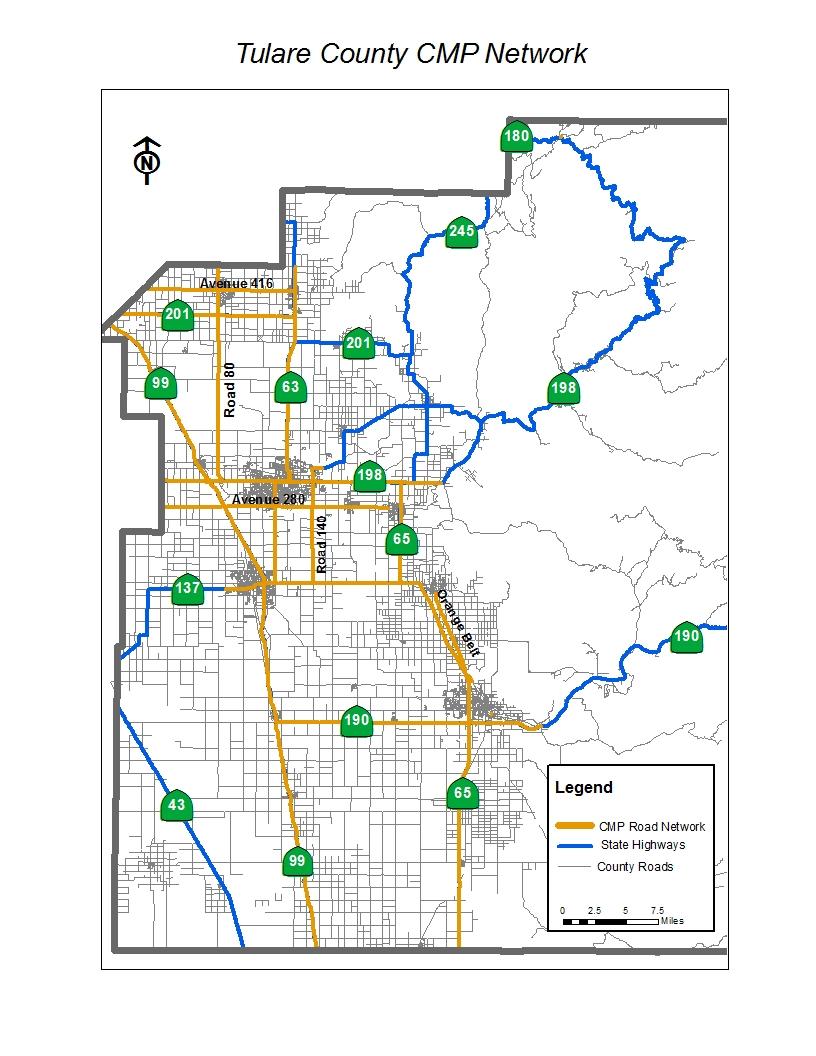
7 4. The Tulare County CMP Network Tulare County's steady growth rate is increasing demands on the existing transportation system. In some cases, traffic has exceeded roadway capacity and mitigation measures are needed to relieve congested areas. In order to provide the most fair assessment of the transportation system in the region, traffic conditions should be studied countywide in the congestion management process. However, due to limited resources, the facilities that were studied in this process were limited to Regionally Significant Roads defined as, roads designed to maintain and improve access between cities, accommodate a high level-of-service access to and within the Visalia-Tulare Area, and to link regionally significant commercial, education, industrial and recreational facilities. The criteria used to establish the regionally significant system included factors such as functional classification, service to regional facilities, connection of regional facilities, and amount of current and future projected use. The Tulare County CMP Network was approved by the CMPSC in March As shown on Figure 2 below, the network consists of most state freeways and highways within the valley portion of Tulare County, as well as several regionally significant roads: Avenue 416 from State Route 63 to the Fresno County line. Road 80 from State Route 198 to the Fresno County line. Avenue 280 from State Route 65 to the Kings County line. Road 140 from State Route 216 to State Route 137. Orange Belt Avenue between Porterville and Lindsay. Numerous urban and rural intersections throughout the County which are not included in the CMP network will also be monitored for potential congested conditions.
8
9 5. System Monitoring: The CMP network will be monitored for potential congested conditions on an ongoing basis using performance measures contained in the CMP. Initially, volume to capacity (V/C) levels may be used to establish a set of deficiencies that should be considered for mitigation using CMP strategies. Subsequent efforts in the CMP will focus more on travel time as the permanent performance measure. Highway Performance Monitoring System (HPMS) The Highway Performance Monitoring System (HPMS) is a federally mandated inventory system and planning tool, designed to monitor the effectiveness of the nation s highway system. HPMS is used as a management tool by state and Federal governments and local agencies to analyze the system's condition and performance. HPMS data is used for: Allocation of Federal funds to the states. Travel trends and future transportation forecasts. Environmental Protection Agency (EPA) air quality conformity tracking. Data for Biennial Report to Congress on the State of the Nation s Highways. TCAG staff works with our local jurisdictions and Caltrans to provide current traffic volume and other data for the HPMS program. Each year Caltrans prepares and publishes a report, by county and city, of the estimated maintained mileage and daily vehicle miles of travel for all counties and cities in the state based on the HPMS data provided. Travel Time Survey Travel time surveys will be collected on major corridors such as SR99, SR198 and SR190. This will provide real world travel time data that can be used to identify congested roadway segments. Those roadway segments could be studied further to determine the root cause of the congestion whether it is operational issues, recurring incidents, insufficient capacity or other causes. Additional studies could be conducted to identify potential roadway improvements.
10 Traffic Count Collection Program As a necessary function of calibrating and validating the TCAG Transportation Forecast Model, TCAG collects classified traffic counts from up to 100 locations annually throughout the County. The counts are collected a specific locations on the transportation network (screen lines and gateways) designed to intercept the major travel movements into, out of, and within the County. In addition, TCAG coordinates with its member agencies and Caltrans to share in the use of traffic count data collected by these agencies. In all, a significant volume of traffic count data is collected and available annually to assess potential areas of traffic congestion within the county. Intersection Monitoring Program Since 1997 TCAG has monitored a minimum of 50 intersections per year throughout Tulare County. The monitoring program has assisted local agencies in identifying signalized and stop-controlled intersections that operate at unacceptable levels of service. This data is valuable to the local agencies in determining the need, and appropriate mitigation for alleviating potential congestion, such as installing traffic signals, adding lanes, and optimizing signal timing and phasing. It is expected that the number of intersections monitored under this program will increase over time based on the identification of specific areas of concern for recurring congestion. Transit Monitoring: Under California Transportation Development Act, local transit providers are required to conduct a performance audit of their respective transit system every three years (the Triennial Performance Audit). The purpose of this audit is to evaluate the transit agency s use of public funds in efficiently and effectively providing public transportation services to the public. The audit identifies specific performance recommendations which can, and should be taken by the operator to improve local and regional services. Additional monitoring may be done by the local providers to determine how well their system is meeting the needs of the public, and determine where improvements are needed. The local providers routinely monitor system ridership and on-time performance as indicators of the efficiency of the system.

11
12 6. System Performance The development of performance measures to identify and assess congestion is a critical element of the congestion management process. Sound performance measures serve an objective way to gage the initial and ongoing success of meeting the CMP objectives. In other words, they are the best way to track progress on mitigating congestion on the system. Performance measures should display the following characteristics: o They should be realistic and practical. o Easily understood by the public, staff, and elected officials so they can be incorporated into the overall transportation planning and decision-making process. o They should be sensitive to the various modes of transportation such as automobile, bike/pedestrian, and transit. o They should be sensitive to the duration and type of congestion experienced and/or anticipated, both in an urban and rural setting. o They should be sensitive to environmental concerns. o They should be able to be modeled and forecasted in order to estimate future congestion levels. Still, the most significant requirement is that the performance measures be based on the availability of sound data and data collection. A comprehensive set of performance measures will not be useful without reliable data to back them up. The CMPSC, in taking these characteristics into consideration, has established the following list of performance measures for the Tulare County CMP:

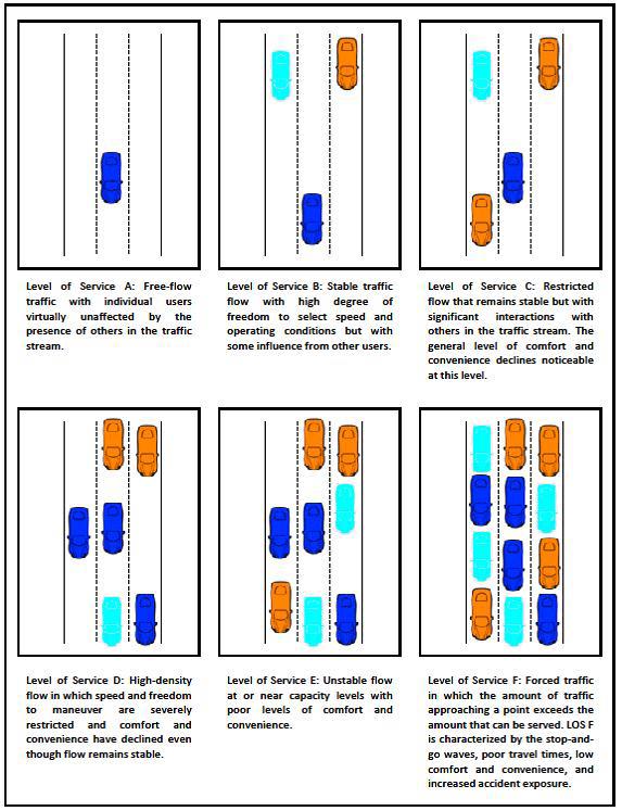
13 As stated above, Tulare County does not experience the same level of congestion on its highways, streets, and roads as larger urban areas in the state. However, congestion does occur, and is expected to increase over time with increasing population. Current emphasis has been on assessment of the regional network based on a Level of Service (LOS) standard, Figure 3. TCAG expects that the initial assessment of the CMP network will follow this process until a change to the more user-sensitive travel time standard can be implemented.
14
15 6. Strategies Demand and Access Management Travel demand management (TDM) strategies are an integral component in managing congestion. TDM consists of managing behavior regarding how, when and where people travel. TDM strategies are designed to reduce vehicular trips during peak hours by shifting trips to other modes of transportation and reduce trips by providing jobs and housing balance. TCAG participates in or encourages the following TDM strategies: Public Transit o Modification of bus routes o Bus rapid transit o Improve transit facilities and safety o Improve modal access (connectivity within modes) o Improve rider amenities Land Use / Growth Management o Encourage TOD and mixed use development o Encourage Infill development Other TDM Strategies o Ridesharing o Park and Ride o Safe Routes to School o Van Pooling o Encourage alternative work programs One program that has worked successfully in Tulare County is the placement of bike racks on transit buses. This creates an interface between bicycles and transit that broadens the options for commuters to leave their cars at home. Bicycle racks and lockers conveniently located near transit stops make the interface more attractive. The County of Tulare, Tulare Transit Express, Visalia City Coach and Porterville Transit are all equipped with bicycle racks. Tulare County Association of Governments and its agencies have begun partnering with adjacent counties. TCAG partnered with Fresno COG on their Carpool website ( The website allows Tulare County and Fresno County residents to match with carpool interests that have similar originations and destinations. The website also provides information on multi-modal use including transit information and bicycle/pedestrian facilities. TCAG is a supporter and sponsor of South Valley Rideshare which is managed through Kings Area Rural Transit.
16 Through education, TDM strategies can be implemented and utilized in the circulation system. However, in order to change traveling habits, employers must suggest transportation alternatives such as eliminating single vehicle occupant trips. Transportation System Management Transportation System Management (TSM) is designed to identify short range, low cost capital projects that improve operational efficiency of existing infrastructure. An effective TSM program using appropriate techniques can improve circulation and reduce automobile emissions. TSM s are an important tool endorsed by the San Joaquin Air Pollution Control District (SJVAPCD) and state to meet air quality standards and congestion management levels-of-service. TSM s are used in coordination with TDM s and TCMs to improve the local and regional environment. TCAG encourages the following TSM strategies in the 2014 RTP: traffic signal synchronization; traffic engineering and flow improvements; turning and bus pocket bays; bus terminals; removal of on street parking; limit arterial street access; street widening; and bicycle facilities. Intelligent Transportation Systems (ITS) Intelligent transportation systems improves transportation safety and mobility through the integration of advanced communications technologies into the transportation infrastructure and in vehicles. ITS encompass a broad range of wireless and wire line communications-based information and electronics technologies. An Urbanized Area ITS Plan was developed in 2001 for the Visalia Urbanized Area. The update of this plan is scheduled for 2015 and may include additional cities in Tulare County. In November 2001 the Tulare County Association of Governments (TCAG) adopted the San Joaquin Valley Intelligent Transportation System (ITS) Strategic Deployment Plan. To remain relevant, the ITS Deployment Plan requires periodic maintenance and update. In order to accomplish this, the eight San Joaquin Valley Councils of Government adopted the San Joaquin Valley ITS Maintenance Plan and formed an established the ITS Maintenance Team to address potential updates to the Deployment Plan. Changes to ITS in the valley, such as newly implemented projects or changes in agency priorities are documented through periodic updates to the Strategic Deployment Plan.
17 The goal of the San Joaquin Valley Maintenance Plan is to foster the integration or regional ITS systems and define the system components, key functions, stakeholders, and information sharing. It guides the development and deployment of ITS projects and safeguards against loss of federal funding. The ITS Maintenance Team consisting of representatives from each of the San Joaquin Valley COGs is responsible for implementation of the maintenance plan. An update of the current San Joaquin Valley ITS Architecture is currently in process. No specific schedule has been established, but TCAG will continue to coordinate with the San Joaquin Valley ITS Maintenance Team to discuss possible update strategies, attend trainings by FHWA and other entities related to updating the ITS architecture, and assemble planning and transportation data as necessary to support a possible update. The following strategies are encouraged by TCAG: ITS o Traffic system operational improvements o Access management o Freeway management o Transit coordination 7. Implementation State Transportation Improvement Program The STIP is a multi-year capital improvement program of transportation projects on and off the State Highway System, funded with revenues from the Transportation Investment Fund (Prop 42) and other funding sources. STIP programming generally occurs every two years. The programming cycle begins with the release of a proposed fund estimate, followed by California Transportation Commission (CTC) adoption of the fund estimate. The fund estimate serves to identify the amount of new funds available for the programming of transportation projects. Once the fund estimate is adopted, Caltrans and the regional planning agencies prepare transportation improvement plans for submittal. Caltrans prepares the Interregional Transportation Improvement Program (ITIP), using Interregional Improvement Program (IIP) funds, and regional agencies prepare Regional Transportation Improvement Programs (RTIPs) using Regional Improvement Program (RIP) funds. Public hearings are held in both northern and southern California. The STIP is then adopted by the CTC. This process, as well as the fund distribution process, are outlined in charts available on the Caltrans Transportation Programming website: The IIP funds make up 25% of the total STIP funds, which are available for State
18 Highway, intercity rail, grade separation, and mass transit improvements included in the Caltrans IIP. The RIP funds represent 75% of the total STIP which are available for use on State Highways, grade separation projects, transportation system management projects, soundwalls, rail transit projects, local street projects, intermodal facilities, pedestrian and bicycle facilities. TCAG uses RIP funding only on state highway projects. The projects must be included in the RTIP, which is prepared by TCAG and submitted to Caltrans and the CTC for adoption into the STIP bi-annually with a yearly augmentation as needed (March each year). Table 4-1 displays the STIP cycles and TCAG s estimates for STIP funding through FY 2039/40. Measure R Measure R, passed in 2006, is a local ½ cent sales tax initiative approved by the voters (see Appendix M). The sales tax is estimated to bring in over $1.4 billion over its 30-year lifespan. The measure includes many types of projects, from large, capacity-increasing projects on state highways and major regional roads, to numerous bicycle projects, transit expansion projects, and environmental funds. For a more detailed review of funding sources, please refer to the Financial Element. Other Funding Proposition 1B, Congestion Mitigation and Air Quality Program (CMAQ) 8. Conclusion The congestion management process is a procedure that gets integrated into virtually every facet of the regional transportation planning process. Looking at ways to improve the safe and efficient movement of people and goods through better management of our existing transportation system is essential, given the time it takes to develop major projects and the limited resources and growing competition between the various modes of transportation. Developing the right mix of strategies provides the ability to offer transportation choices to the traveling public while getting the most from the transportation that currently exists.